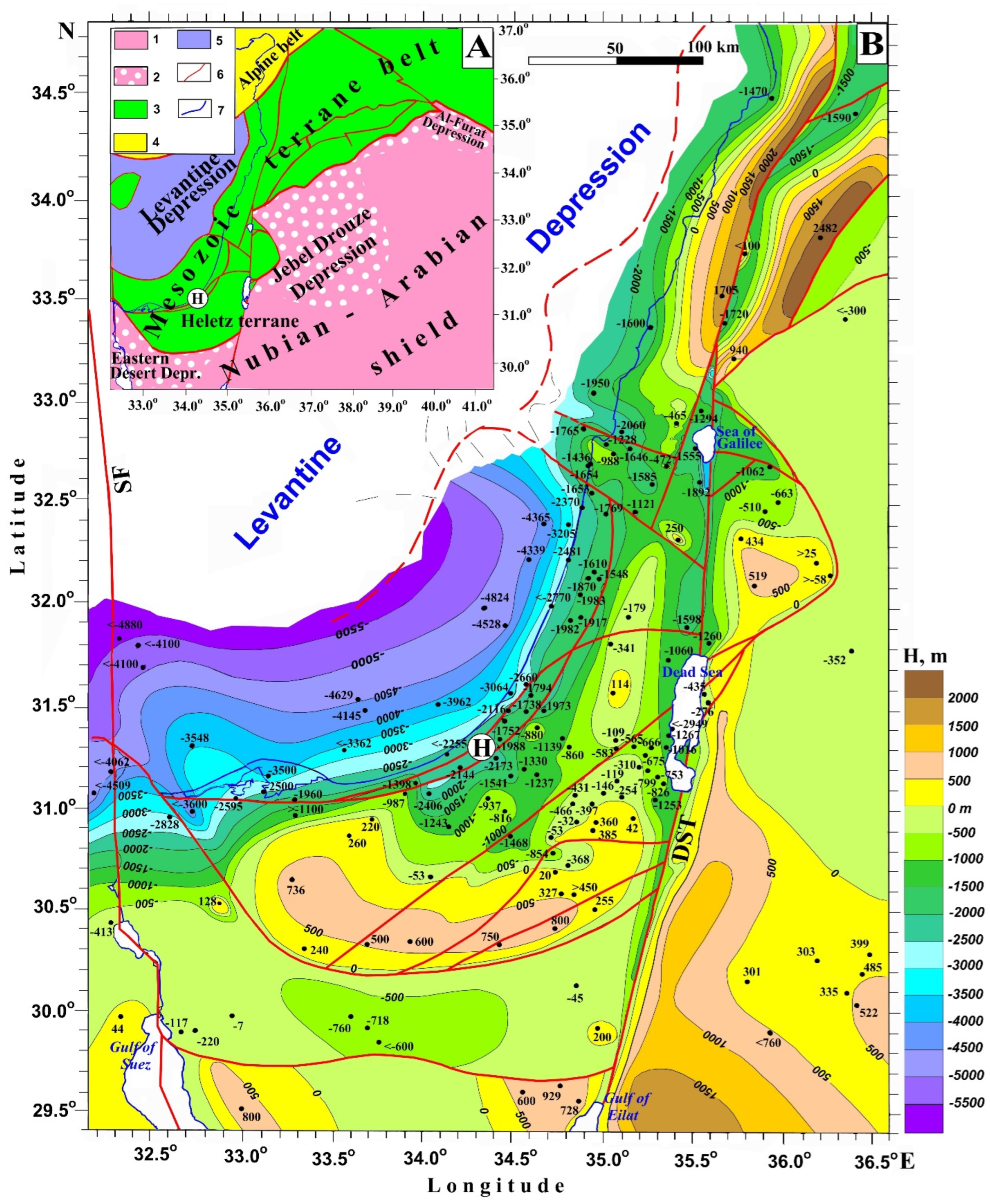
The constructed maps and their meaning will be discussed in detail below.
4.1. Post-Collisional Complex
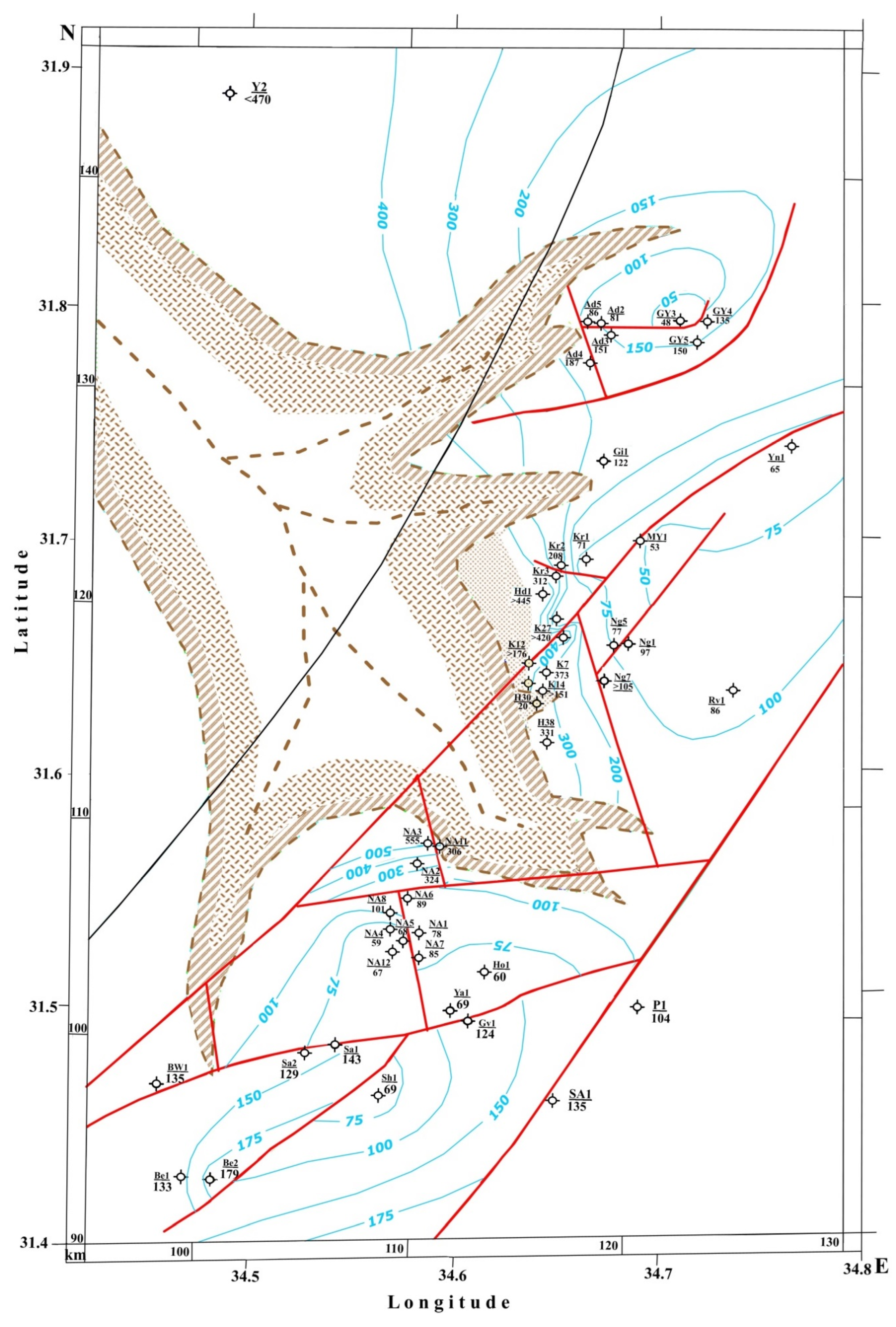
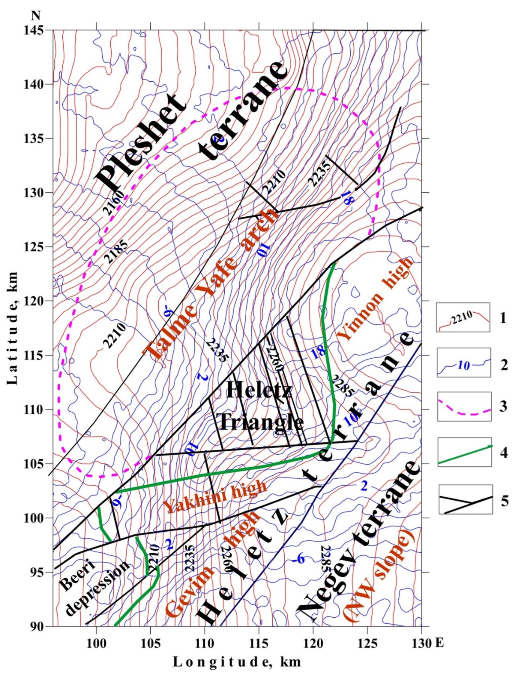
The upper Neogene-Quaternary structural stage of the post-collision complex (
Figure 2) has the simplest structure regarding the tectonic–geodynamic analysis. It includes two main structural zones: (1) a coastal uplift of the carbonate platform, including the Negev and Heletz terranes, and (2) a trough with strong tectonic subsidence at the boundary of the Heletz and Pleshet terranes. From the zone of uplift to the tectonic ledge along the diagonal fault, an erosional incision is stretched, which is a relic of the late Messinian crisis, which manifested itself as a unique catastrophe—the drying of the bottom of the Mediterranean Sea. The valley of the erosional canyon under consideration extended on the elevated part of the plateau at a distance of about 50 km from the eastern part of the Negev terrane to the northeastern part of the Heletz terrane [
6,
17,
39].
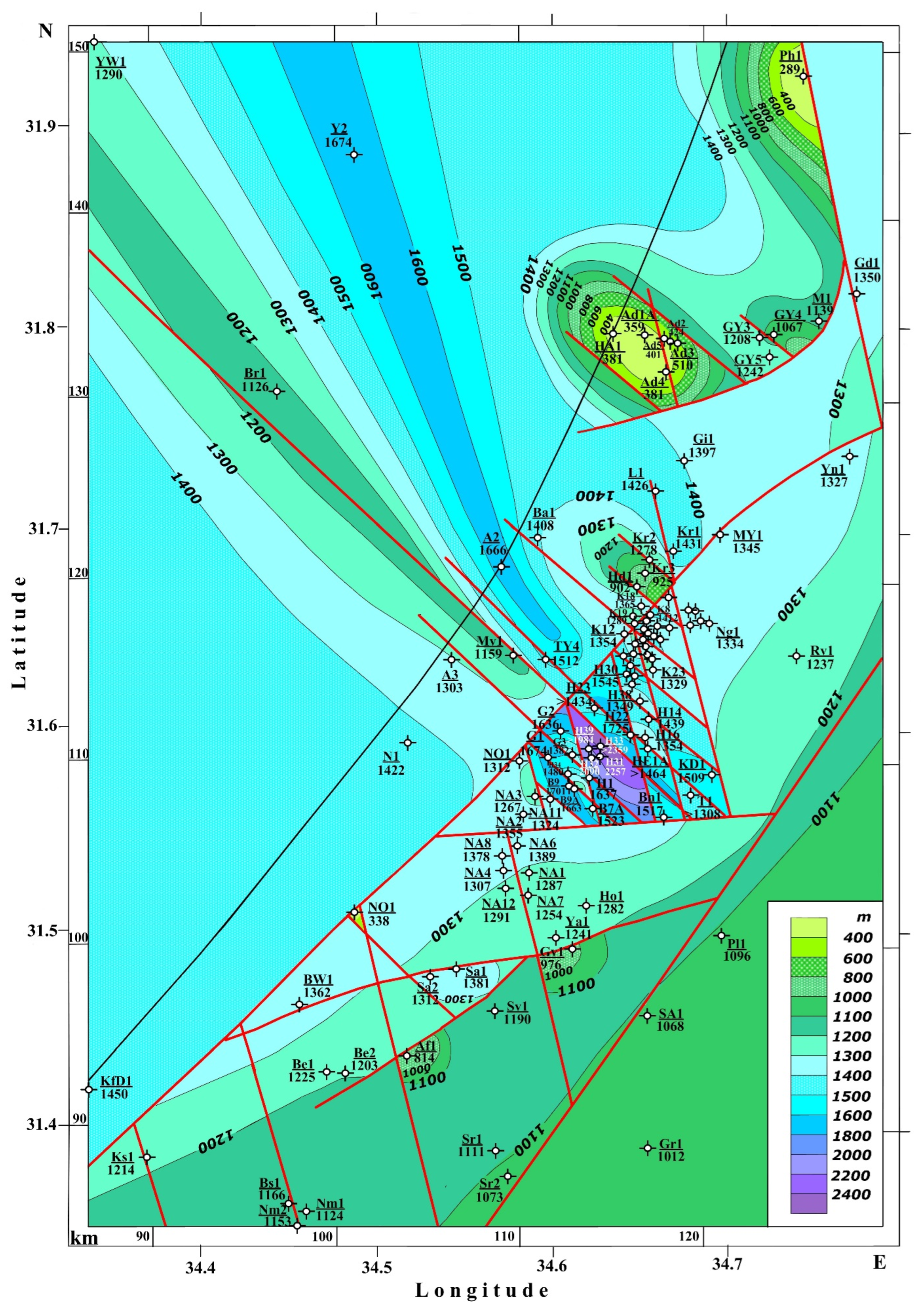
The uplift and trough zones are not subject to any noticeable folding. This feature is very significant from the tectonic–geodynamic standpoint. It illustrates that the stage under consideration belongs to the final scene of the tectonic collision of the Alpine geodynamic cycle. At this stage, the contrast of uplifted coastal uplifts—consolidated marginal belts of tectonic plates—and powerful internal sedimentary troughs that make up the relict collision zone of the former ocean are clearly manifested. This provision is essential from the standpoint of the search for hydrocarbon deposits we will consider later.
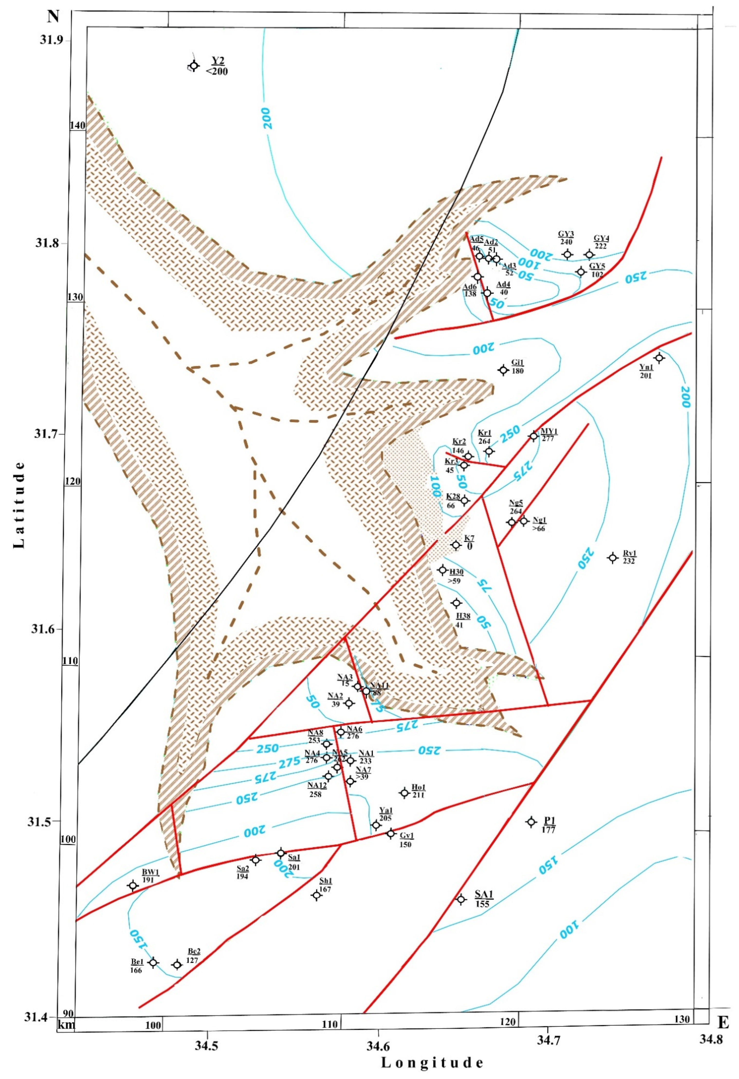
The Paleogene and Upper Cretaceous structural maps (
Figure 3 and
Figure 4) represented the middle and lower levels of the post-collision complex when the Mesozoic terrane belt (MTB) and the Neotethys Ocean geodynamically formed a single structure experiencing differentiated uplifts and subsidence [
17]. The details of such differentiated structure formation are vital for the search for hydrocarbons. The Paleogene thickness distribution map of the Heletz oil exploration fields and adjacent areas (
Figure 3) delineates the uplifted zone of the Negev and Heletz terranes and the relatively subsided zone of the Pleshet terrane. In this way, in general terms, it precedes the geodynamic stage of the Neogene-Quaternary stage. It is distinguished by a significant gently sloping folding—the development of elongated synclinal and anticlinal swell-like structures with an insignificant amplitude of uplifts and subsidence. The most abrupt zone of structural transition is the boundary of the Heletz and Pleshet terranes. A narrow ridge of this erosion zone of Paleogene deposits at a distance of 2 to 5 km sharply passes into a spot of increased thickness up to 600–800 m. To a certain extent, such an effect, as it were, precedes the subsequent subsidence of the basin of the Eastern Mediterranean in the Neogene-Quaternary time.
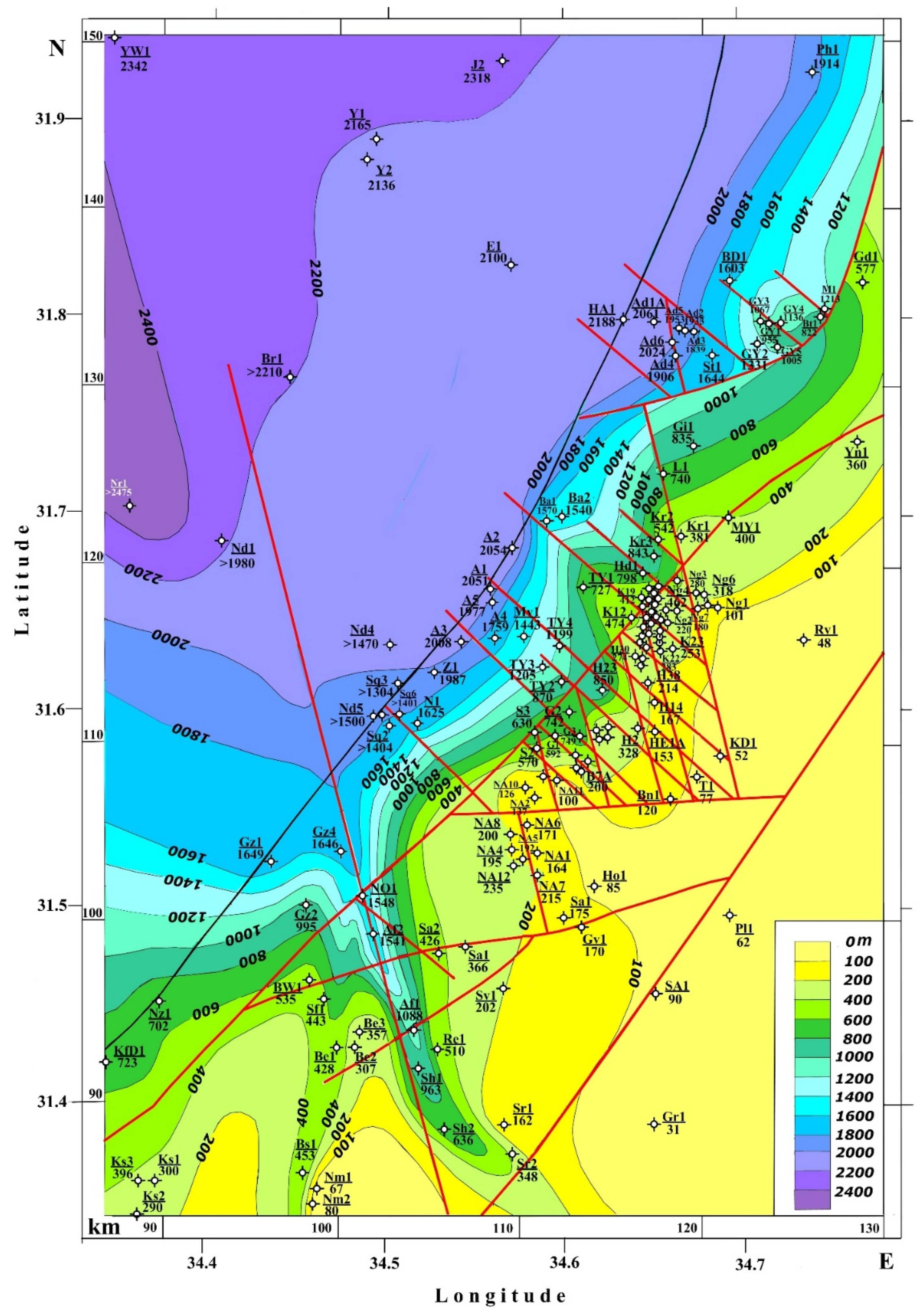
The lower stage of the post-collision complex (
Figure 4) differs significantly from the Paleogene stage in significant differentiation of the structures of the terrane belt. A sharp zone of tectonic uplift is distinguished here, associated with the boundary of the Heletz and Pleshet terranes, where the Upper Cretaceous deposits are entirely eroded in the area of a relatively wide ridge of uplifts. According to the regional mapping data [
17], such swells are developed throughout the Negev and Pleshet terranes field. Thus, the marked structural differentiation, as it were, inherits the previous (collisional) stage of arch-like uplift of blocky structures of the MTB. This structural and geodynamic phenomenon can be used for the directed search for hydrocarbons on the shelf and in the zone of development of the oceanic crust of the Eastern Mediterranean.
This phenomenon is all the more relevant because in the Upper Cretaceous carbonates of the Upper Campanian and Lower Maastrichtian of the Negev and Pleshet terranes, significant deposits of “black shales” [
6,
30]—upwelling facies that form hydrocarbon deposits in many parts of the world [
45]. The northern part of the Pleshet terrane has been explored and created large commercial deposits prepared for development [
8,
12,
46].
Figure 2.
Neogene-Quaternary structural–paleogeographic map of the Heletz–Ashdod oil field and adjacent areas (isopach intervals are given in m). Borehole abbreviations: A, Ashkelon, Ad, Ashdod, Af, Afiq, B, Brur, Ba, Barnea, Be, Beeri, Bn, Binyamin, Br, Bravo, Bs, Bessor, Bt, Bitsaron, BD, Bene Darom, BW, Beeri West, E, Echo, G, Gevar Am, Gd, Gedera, Gi, Givati, Gr, Gerar, Gv, Gevim, Gz, Gaza, GY, Gan Yavne, H, Heletz, Hd, Hodiya, Ho, Hoga, HA, Hof Ashdod, HE, Heletz East, J, Joshua, K, Kokhav, Kr, Karmon, Ks, Kissufim, KD, King David, KfD, Kfar Darom, L, Lior, M, Mivtah, Mv, Mavkiim, MY, Massuot Yizhak, N, Nissanit, Nd, Nordan, Ng, Negba, Nm, Nirim, Nr, Nir, Nz, Nezarim, NA, Nir Am, NO, Nahal Oz, Ph, Palmahim, Pl, Pleshet, Rv, Revaha, S, Shimon, Sa, Saad, Sf, Sahaf, Sh, Shuva, Sq, Shiqma, Sr, Sharsheret, St, Shetulim, SA, Sedot Akiva, T, Telamim, TY, Talme Yafe, Y, Yam, Ya, Yakhini, Yn, YW, Yam West Yinnon, Z, Ziqim.
Figure 3.
Paleogene structural–paleogeographic map of the Heletz–Ashdod oil field and adjacent areas. Borehole abbreviations: see captions for
Figure 2.
Figure 3.
Paleogene structural–paleogeographic map of the Heletz–Ashdod oil field and adjacent areas. Borehole abbreviations: see captions for
Figure 2.
Figure 4.
Late Cretaceous structural–paleogeographic map of the Heletz–Ashdod oil field and adjacent areas. Borehole abbreviations: see captions for
Figure 2.
Figure 4.
Late Cretaceous structural–paleogeographic map of the Heletz–Ashdod oil field and adjacent areas. Borehole abbreviations: see captions for
Figure 2.
4.2. Collision Complex (Early Cretaceous)
Classical regional studies on the regional geology of the Near East [
6,
23,
47] showed that in this area, in the transition zone of the Neotethys Ocean and the Gondwana Precambrian plate in the middle Mesozoic, between the thick carbonate the Jurassic and Upper Cretaceous strata formed an anomalous transitional sediment complex. Here, dominated terrigenous continental and partly marine formations and basalt traps [
48], in places reaching 500 m in thickness [
40]. The boundary deposits and structural complexes of the Jurassic and Lower Cretaceous of the Eastern Mediterranean, and especially the territory of Israel, are well and comprehensively studied geologically and contain a huge number of radiometric dates (e.g., [
49]).
Regional structural-sedimentary studies [
17] show that, in general, the collisional complex in the Early Cretaceous geodynamically differed sharply from the adjacent Precambrian shield of Gondwana by a significant thickness difference. Taking into account these data, as well as the phenomena of plate geodynamics in the transition zone of terrane massifs from the thinned continental crust and ophiolite sheets displaced from adjacent areas of the Tethys Ocean, the Levantine phase of the terrane belt consolidation was established, corresponding to the boundary of the Early and Late Hauterivian [
50]. After the collision of blocks of continental and oceanic crust and the previous active erosion of the uplifted carbonate platform of this belt, its later movements could also occur, in the second half of the Early Cretaceous, when the thickest Aptian–Albian trap fields were formed to the north [
36].
The northern part of the MTB was uplifted, and structural zones were distinguished in the Aleppo and Abdelaziz terranes, where the Lower Cretaceous was absent. The underlying formations were subjected to significant erosion. This erosion is especially clearly demonstrated by regional maps of the underlying Jurassic deposits, where the phenomenon of the Levantine uplift phase is reflected in the absence of Jurassic sediments in the Aleppo terrane and the western half of the Abdelaziz terrane.
Judging by the Jurassic thickness of the more southerly terranes displaced by 500–1000 km in the process of rotational motions counterclockwise in the southeast direction [
18,
19], the amplitude of the early secondary erosion of the Aleppo and Abdelaziz uplifts of the MTB could reach 1500–2500 m. In the Early Cretaceous, the southeastern part of the terrane belt moved to the Neotethys Ocean, on the contrary, was involved in active downward movements. Evidence of downward movements in the southeastern part of the terrane belt was obtained in the Makhtesh Ramon erosion-tectonic canyon, where more than 10 m blocks of Oxford limestone (“limestone blocks”) with basaltoid and trachyte dikes of 135.1 Ma age were found brought to the surface [
28,
47]). The nearest Oxford formations are located 30 km to the north, in a different tectonic block, in the borehole Boqer-1 [
31]. We explained this circumstance by underthrusting the subterrane block systems of the Negev terrane during their mutual displacement [
51].
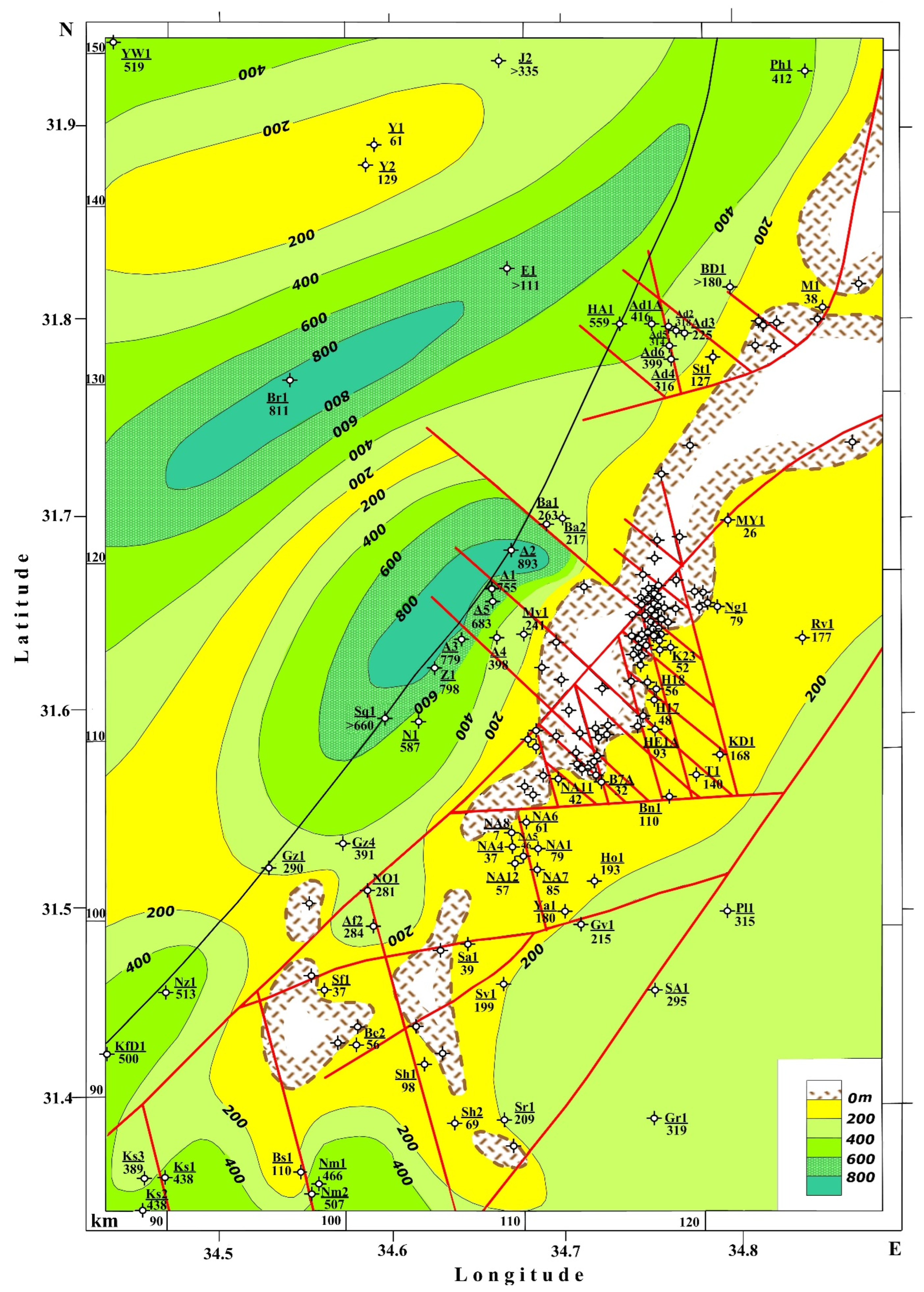
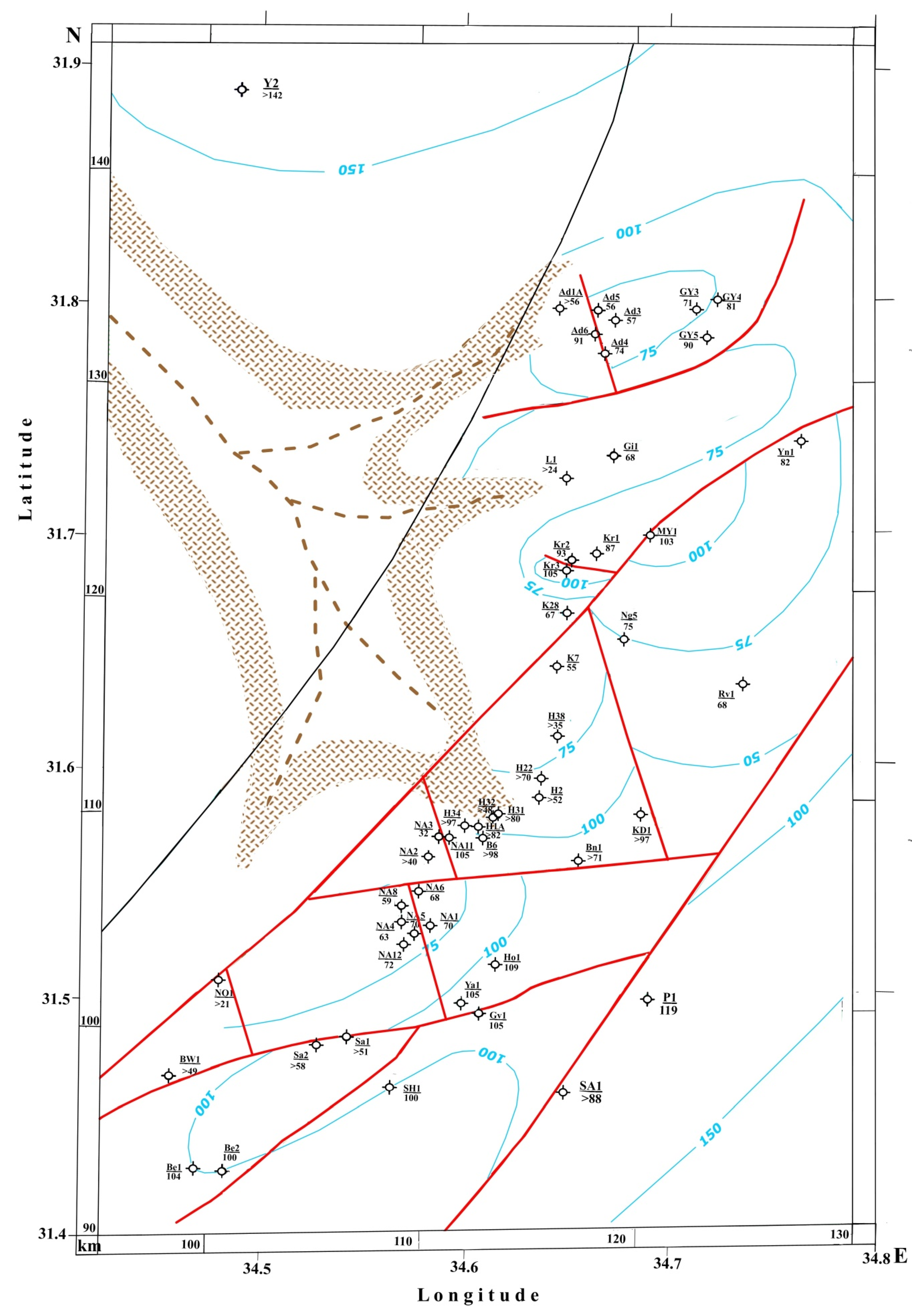
Thus, descending movements during terrane movements in the region’s southeast-prevented significant phenomena of early secondary erosion of Jurassic deposits near the Neotethys Ocean. A reasonably distinct general subsidence in the Early Cretaceous occurred near this ocean. This is reflected in the structural map with the syn-sedimentary control of the Heletz oil-bearing basin and adjacent areas (
Figure 5 and
Figure 6). Generally, the considered map is closest in type to the structural-sedimentary map of the Neogene-Quaternary stage (
Figure 2).
Figure 5.
Early Cretaceous structural–paleogeographic map of the Heletz–Ashdod oil field and adjacent areas. Borehole abbreviations: see captions for
Figure 2.
Figure 5.
Early Cretaceous structural–paleogeographic map of the Heletz–Ashdod oil field and adjacent areas. Borehole abbreviations: see captions for
Figure 2.
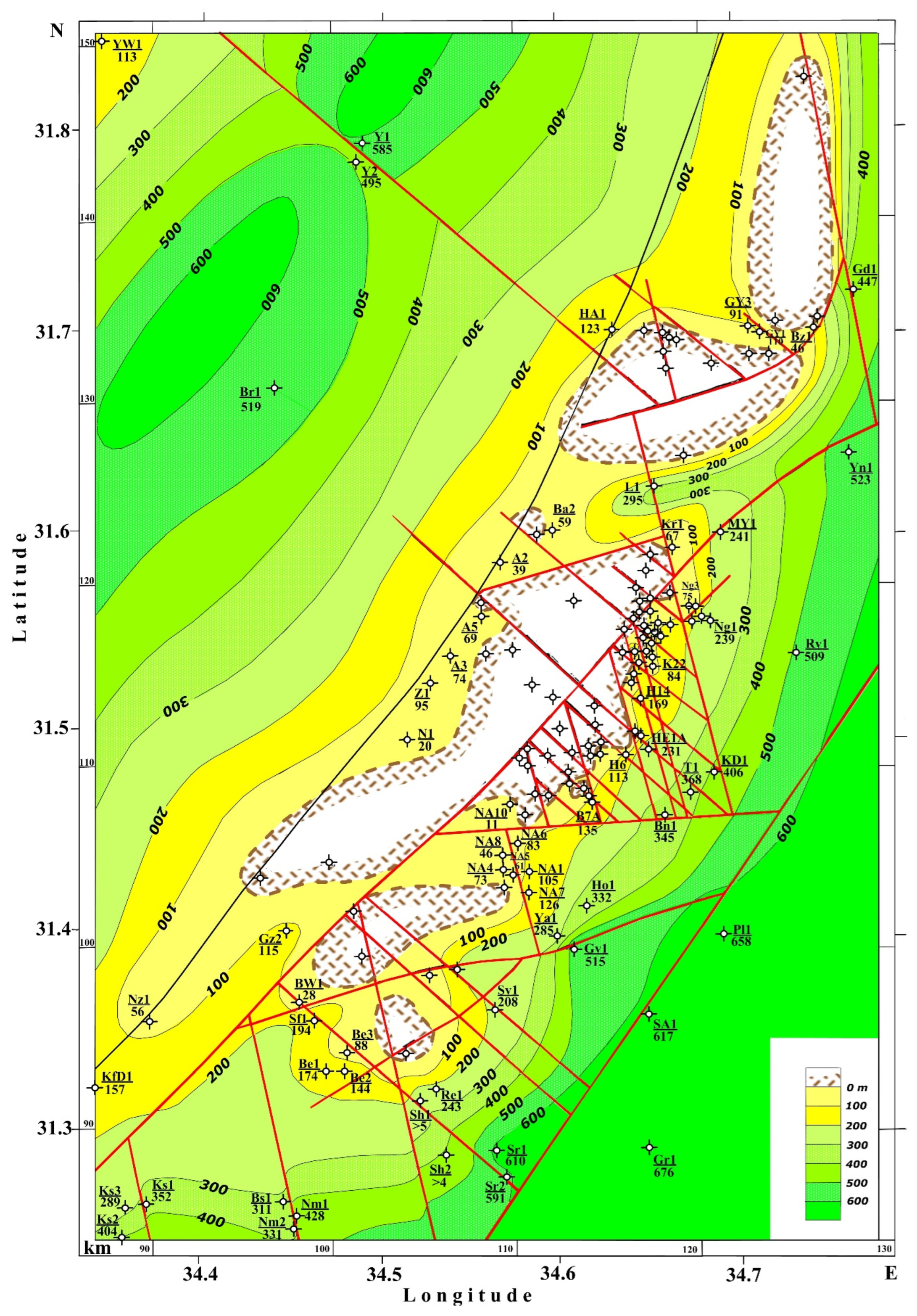
Figure 6.
Early Cretaceous structural–paleogeographic map of the Heletz oil field. Borehole abbreviations: see captions for
Figure 2.
Figure 6.
Early Cretaceous structural–paleogeographic map of the Heletz oil field. Borehole abbreviations: see captions for
Figure 2.
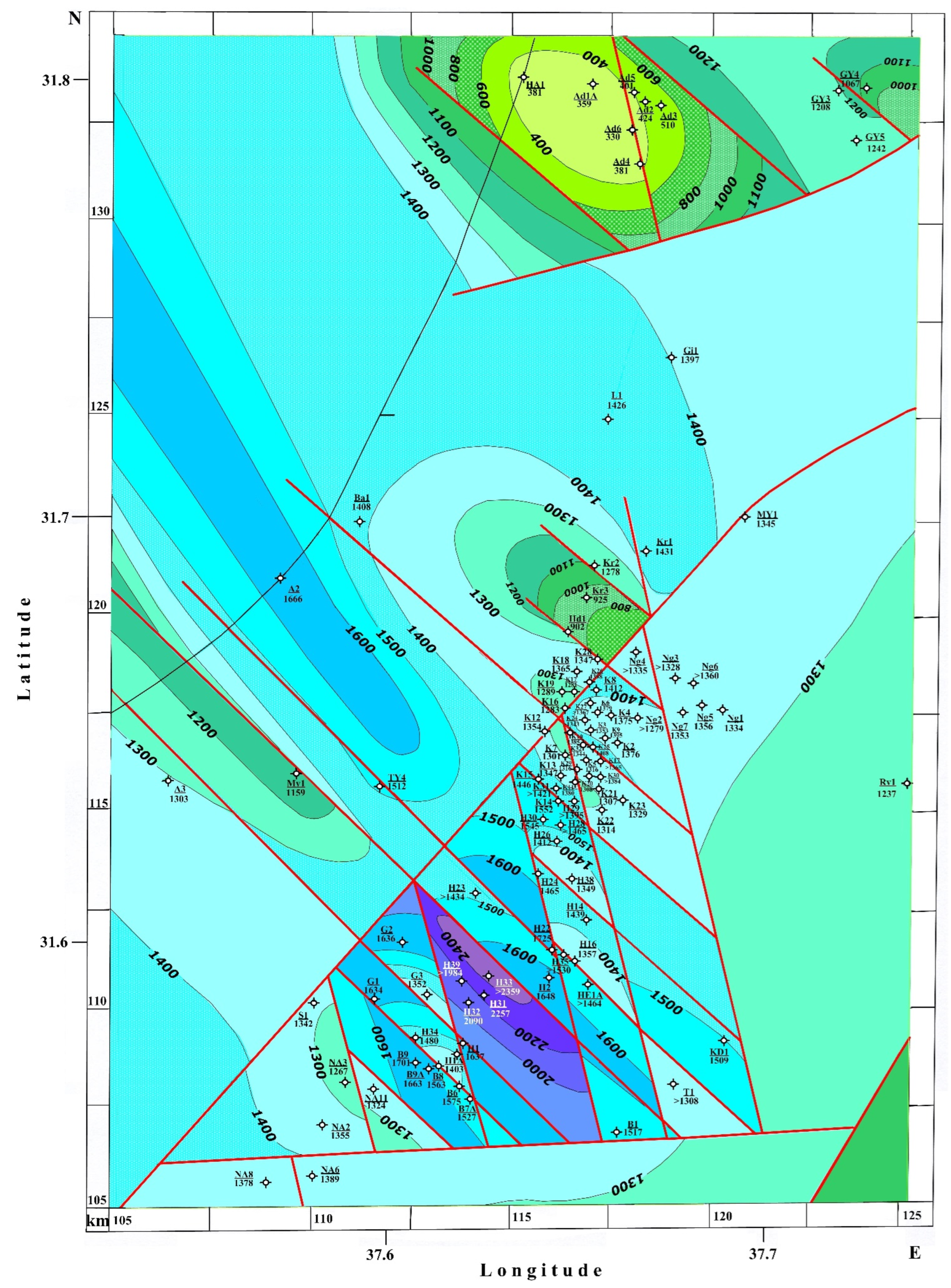
Here, a clear tectonic step of the differential is distinguished from the uplifted Negev-Heletz terrane and the subsided Pleshet terrane. At the same time, an analogy is clearly seen between the erosional canyon of the Messinian age and the Early Cretaceous oil-bearing Heletz canyon. The difference lies in the development of local movements in the Early Cretaceous, which led to the formation of low-amplitude brachyanticlinal structures in the Heletz and Pleshet terranes. The most dislocated are the Lower Cretaceous rocks of the Heletz triangle (
Figure 6).
Here, a unique fold-block system was formed in the era of the MTB collision with the Precambrian continental platform Gondwana and the Neotethys oceanic plate. In the center of the system is a brachysynclinal fold with the maximum thickness of the Lower Cretaceous deposits for the Eastern Mediterranean, exceeding 2359 m.
4.3. Paleogeographic and Palaeogeological Mapping of the Early Stages of the Collisional Complex
The initial stages of structure formation and geodynamics of the Mesozoic collisional complex of the Eastern Mediterranean cover the Jurassic-Cretaceous boundary and correspond to the final stages of the Late Jurassic and the first half of the Early Cretaceous-Neocomian—from the Berriasian to the Barremian. This is the stage of the equatorial contraction of the Earth’s figure and the corresponding equatorial regression [
52]. Therefore, this area, located south of the critical parallel of 35 degrees N, studied for more than 70 years by various scientific studies, is a reference in terms of structural, geodynamic and paleogeographic analysis of the Mesozoic history of Gondwana.
To identify and analyze these processes, we relied on the classical methodology of geotectonics—the analysis of breaks and unconformities. It consists of the construction of special maps of the hiatus surface—structural-geomorphological (
Figure 7), palaeogeological erosion maps (
Figure 8), etc. Such maps indicate the amplitude of uplift and subsidence under conditions of differentiation of tectonic structures in the zone of the unconformity surface.
The structural geomorphological map of the Heletz erosional canyon was published earlier [
7] and taken into account in the practice of specialized studies in the field of optimizing further hydrocarbon exploration in this area [
42]. This circumstance contributed to the fact that we carried out further processing and refinement of the map due to a more careful consideration of available drilling materials [
31]. This new variant (
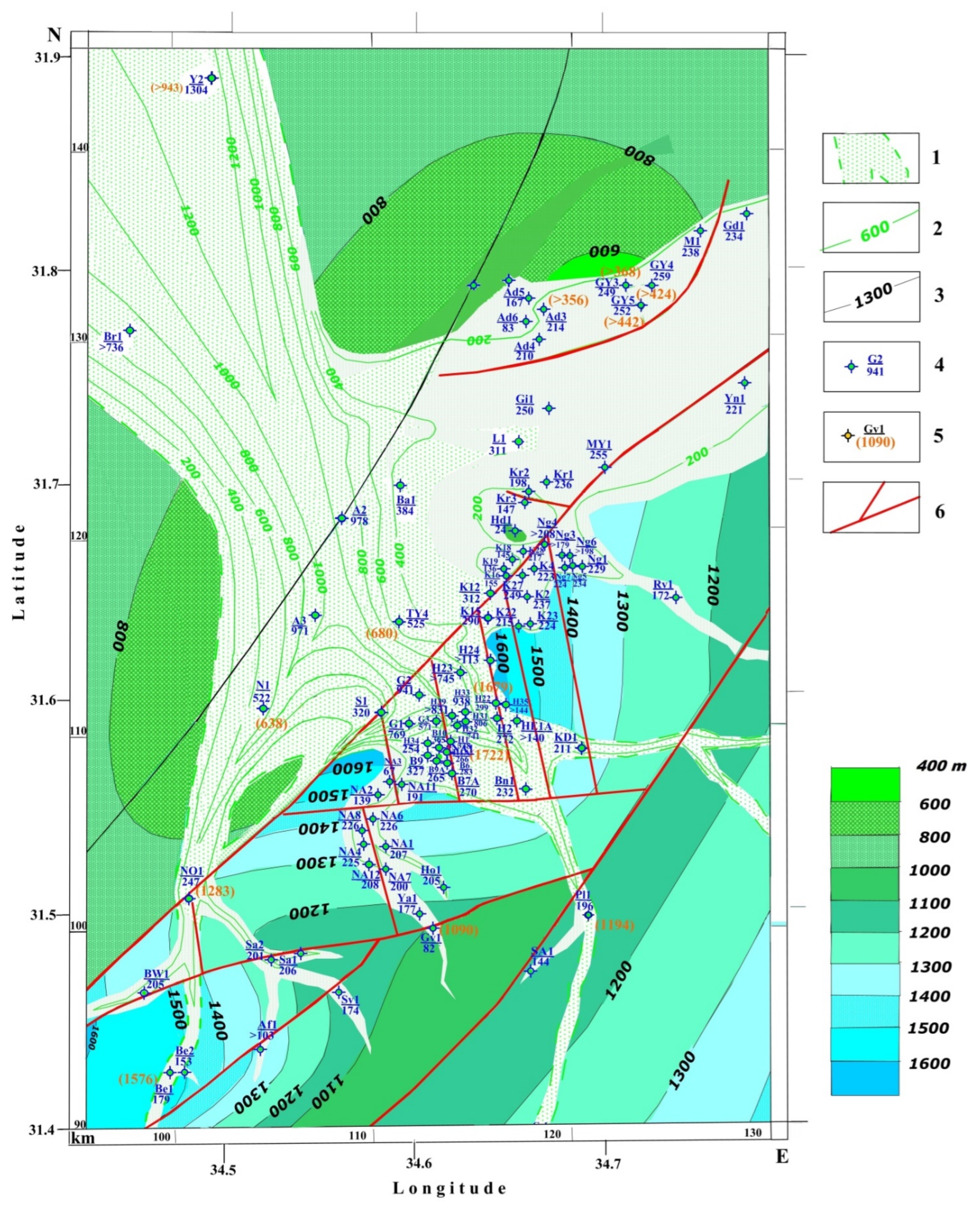
Figure 7) indicates a sharp geodynamic difference between the uplifted Heletz terrane and the subsided Pleshet terrane.
The map clearly shows that at the beginning of the Early Cretaceous, the Heletz terrane was essentially a narrow slope of the northwestern part of the elevated plateau of the Negev terrane carbonate platform. On this plateau, rare narrow incisions of Early Cretaceous river flows are developed, which are replaced on the slope by a more branched system of watercourses and initial vast canyons. Then, at the boundary of the Heletz and Pleshet terranes, this system abruptly changes into a delta-like expansion system. Finally, after 10 km to the northwest, the erosion valley turns into a canyon, and further to the north (the Yam-2 well), the thickness of predominantly terrigenous deposits of the Gevar Am Formation (Neocomian), which fills the canyon, and reaches 1304 m.
The underlying surface of the Heletz Canyon is composed of Jurassic deposits. Their structural map shows the relative homogeneity of the collisional stage tectonic movements in the Pleshet and Negev terranes and a sharp contrast of structures in the Heletz terrane, which is also complicated by a significant number of disjunctives. The triangular Heletz structure appears to be the most unstable, the main structural contrast o appearing on the Lower Cretaceous thickness map (
Figure 6). A comparison of the Jurassic and Cretaceous stages of geodynamics will be given below. Therefore, it is essential to understand the inheritance of tectonic movements of the collisional and pre-collision stages in the MTB.
Figure 7.
Paleogeomorphological map of the GevarAm erosional stage (Hauterivian–Barremian) of the Heletz–Ashdod oil field and adjacent areas. (1) The Early Cretaceous Gevar Am erosional zone, (2) isopachs of the Gevar Am Formation, (3) isopachs of the Upper—Middle Jurassic (Halutza—Upper Inmar formations) (in m), (4) boreholes penetrating Gevar Am Formation (nominator—borehole name and number, denominator—thickness in m, (5) boreholes penetrating Jurassic deposits (nominator—borehole name and number, denominator—thickness in m, (6) faults. Borehole abbreviations: see captions for
Figure 2.
The earliest stage of the considered collisional stage of the Early Cretaceous materialized in the form of premature secondary erosion of Jurassic deposits subjected to deformation. For this purpose, detailed information on the areal distribution and age of eroded and preserved rocks is needed. The Heletz oil field and adjacent prospecting and exploration areas are fine-drilled and thoroughly explored during prospecting and surveying, and the available base materials are in regional reports [
6,
31].
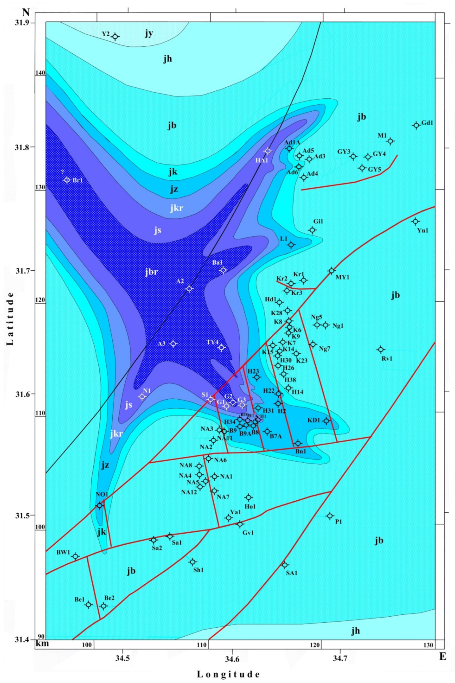
These unique materials of years of research by Israeli geologists made it possible to construct a palaeogeological map of the surface of the Jurassic deposits, confined to the Heletz Canyon and the surrounding land and sea areas (
Figure 8). The stratigraphic volume of eroded deposits in Heletz Canyon from the Titonian Yam Formation to the Bathonian Sederot Formation and the Bajocian Barnea Formation is more than half of the Jurassic section. Geochronologically, it corresponds to a stage of 25 million years, and according to the eroded thickness of sediments, it reaches an amplitude of 1000–1400 m.
The total time of erosion of Jurassic carbonate sediments at the beginning of the Early Cretaceous erosional phase could be from 3.5 to 7.0 Ma. The subsequent erosion could be associated with sharp collapses of sedimentary masses of the Lower Cretaceous sediments on the canyon’s steep sides. These issues are essential to solving hydrocarbon exploration problems, and the palaeogeological map can be used to optimize them. Attention is also drawn to another very significant phenomenon. They are associated with a Lower Cretaceous clastic complex (
Figure 7) filling a deep canyon-like Jurassic erosional trough (
Figure 8). Such thick erosion zones are absent in the higher latitude Galilee–Lebanon, Anti-Lebanon, Judea–Samaria terranes and in the northern part of the Pleshet terrane. It is favored by the absence of oil deposits north of the MTB, similar to the Heletz and Ashdod fields developed in the south.
Our tectonic–paleogeographic and paleomagnetic mapping of these territories [
38,
40,
51] made it possible to identify the cause of gender differences. It is due to the development of a vast field of thick Lower Cretaceous traps in the north. Mobile basaltic lavas quickly filled the erosional topography, preventing the development of canyons, which is clearly seen in the geological and paleomagnetic profiles [
40,
51].
It is significant that because of satellite geophysical data modeling and a thorough regional tectonic analysis, the underlying cause of the difference in geodynamics and tectonic-thermal processes in various parts of the Eastern Mediterranean has been established. This is due to the discovery of a deep mantle structure [
18,
19].
The northern terranes mentioned above were located in the axial zone of this structure, where hot spots formed. They are associated with fields of basalt traps, as well as deeper intrusions containing diamonds and their minerals-satellites [
38,
53]. A second significant circumstance related to the geodynamics of the counterclockwise rotating deep mantle structure. It led to the fact that the terranes’ set moved along transform faults in the Mesozoic at the boundary of the Neotethys and Gondwana in the same direction from NE to SW. Therefore, the oil-bearing southwestern bend of the MTB is located outside the active zone of tectonic-thermal processes. In the Cretaceous period, significantly different geodynamics and the nature of tectonic-sedimentary processes were developed here, which is reflected in the presented maps (
Figure 4,
Figure 5,
Figure 6,
Figure 7 and
Figure 8). Accordingly, the forecast, searches, and prospects for discovering hydrocarbon deposits should be considered depending on the region’s tectonic-geophysical zoning and geological history.
Evidence for filling erosion incisions with basalt—similar in age to the Lower Cretaceous Heletz Canyon—is reasonably well known and studied. In the Samaria region (Wadi Maliah), in the western block of the Anti-Lebanon terrane, a sequence of tuffaceous rocks and basalts was revealed up to 230 m thick (according to the age of the Gevar Am Formation (Neocomian)). These thicker formations are the apex tributary of an erosional valley that is deeper in trapping and extends EW, somewhat crossing the fault line separating the northern Galilee–Lebanon terranes from the more southerly Pleshet and Judea–Samaria terranes [
40]. In the same work, using isopachs, the erosion valley was mapped. According to deep drilling data [
31], to the east, in the Har Amir-1 borehole, the trap thickness is 401 m, and the total Neocomian thickness is 867 m. Further, about 25 km to the west along the line of depression of the erosion valley in the borehole Caesarea-2, the thickness of the traps reaches 463 m, and the total thickness of the Neocomian erosional complex is 1098 m. In the boreholes Caesarea-1 and 3, the thickness of the traps decreases to 184–268 m and the total Neocomian thickness to 591–803 m.
Figure 8.
Palaeogeological map for the top Jurassic of the Heletz–Ashdod oil field and adjacent areas. Jurassic formations: jy—Yam, jh—Halutsa, jb—Beer-Sheva, jk—Kidod, Jz—Zohar, jkr—Karmon, js—Sederot, jbr—Barnea. Borehole abbreviations: see captions for
Figure 2.
Figure 8.
Palaeogeological map for the top Jurassic of the Heletz–Ashdod oil field and adjacent areas. Jurassic formations: jy—Yam, jh—Halutsa, jb—Beer-Sheva, jk—Kidod, Jz—Zohar, jkr—Karmon, js—Sederot, jbr—Barnea. Borehole abbreviations: see captions for
Figure 2.
Comparing the total thickness of the Neocomian in this erosional valley with the Heletz Canyon (
Figure 7), we are convinced of a significant difference in the intensity of erosion processes in the southern parts of the MTB compared to the northern ones. At the same time, the region of the Heletz terrane looks like the highest part of the collision system of block uplifts. According to drilling data, the magnitude of the erosional incision according to the Neocomian sediments filling the canyon in the Heletz 31, Heletz 32, and Heletz 33 wells is 1361 m, 1293 m, and 1514 m, respectively. These maximum values of the erosional incision directly in the Heletz triangle, in the source zone, contrast sharply with the incision data in the north, in Wadi Maliah, up to 230 m and near the mouth, in Caesarea, up to 1098 m.
4.5. Syn-Sedimentation Sequence of the Late-Middle Jurassic of the Pre-Collision Complex
We were able to perform this analysis taking into account the consistent structural mapping with syn-sedimentary controls of the Middle-Upper Jurassic carbonate stratum fractionally dissected in the sections of numerous wells, which survived the early secondary erosion outside the erosional canyon (
Figure 9,
Figure 10,
Figure 11 and
Figure 12). The sequence of structural maps covers half of the Jurassic and, in general, makes it possible to compare the nature of the structural differentiation of the MTB with subsequent stages—collisional and post-collisional.
The uppermost Jurassic horizons, the Yam and Halutsa formations (Tithonian-Kimmeridgian), were almost universally eroded, probably at the end of the pre-collision stage. Therefore, for structural analysis, we used formations that are relatively common in the area and reasonably widely drilled: Beer Sheba (Middle Oxfordian), Kidod (Lower Oxfordian), Zohar (Callovian), and Karmon (Upper Bathonian) (
Figure 9,
Figure 10,
Figure 11 and
Figure 12, respectively). A detailed examination of each structural map indicates the unevenness of information related to the location of the erosion canyon zone, deep drilling areas, and maximum depths of boreholes. Therefore, we will dwell on the general trend that follows from the analysis of each structural map with syn-sedimentary controls.
The Negev terrane represents insignificant material at the boundary with the Heletz terrane. Nevertheless, generally, the amplitude of the zones of syn-sedimentary uplift of the marginal zones of both terranes does not differ significantly. The Heletz triangle depression subterrane is the most differentiated structurally and geodynamically. The most prominent troughs—up to 555 m in the Middle Oxfordian (
Figure 9) are replaced by an uplift zone with an amplitude of up to 50 m in the Lower Oxfordian (
Figure 10). At the same time, in adjacent blocks of the terrane Heletz, the subsidence amplitude was 150–275 m. This cannot be related to the erosion of the zone of the Lower Cretaceous erosional canyon present here since data for the overlying Beer Sheva formation are opposite.
Thus, we can fix the effect of oscillatory movements in the Heletz Triangle block at the end of the pre-collision stage. The data on the syn-sedimentary controls of the Callovian and Bathonian-Zohar and Karmon formations (
Figure 11 and
Figure 12) concerning blocks of the Heletz terrane are different from in Oxford. However, there are still some differences between individual blocks. In the Pleshet terrane, the development of the Ashdod high is common to all structural maps, geodynamically most clearly manifested, similarly to the Heletz Triangle, in the Oxfordian, when the amplitude of its relative uplift compared with the adjacent troughs reached 150 m (
Figure 9 and
Figure 10). These movements were less contrasting in the Callovian and Bathonian (
Figure 11 and
Figure 12).
Figure 9.
A map of the thicknesses of the Middle Oxfordian (Beer-Sheva Formation) of the Heletz–Ashdod oil field. The brown color shows the erosional canyon, and blue lines are the isopachs. Borehole abbreviations: see captions for
Figure 2.
Figure 9.
A map of the thicknesses of the Middle Oxfordian (Beer-Sheva Formation) of the Heletz–Ashdod oil field. The brown color shows the erosional canyon, and blue lines are the isopachs. Borehole abbreviations: see captions for
Figure 2.
Figure 10.
A map of the thicknesses of the Lower Oxfordian (Kidod Formation) of the Heletz–Ashdod oil field. The brown color shows the erosional canyon, and blue lines are the isopachs. Borehole abbreviations: see captions for
Figure 2.
Figure 10.
A map of the thicknesses of the Lower Oxfordian (Kidod Formation) of the Heletz–Ashdod oil field. The brown color shows the erosional canyon, and blue lines are the isopachs. Borehole abbreviations: see captions for
Figure 2.
Figure 11.
A map of the thicknesses of the Lower Callovian (Zohar Formation) of the Heletz–Ashdod oil field. The brown color shows the erosional canyon, and blue lines are the isopachs. Borehole abbreviations: see captions for
Figure 2.
Figure 11.
A map of the thicknesses of the Lower Callovian (Zohar Formation) of the Heletz–Ashdod oil field. The brown color shows the erosional canyon, and blue lines are the isopachs. Borehole abbreviations: see captions for
Figure 2.
Figure 12.
A map of the thicknesses of the Upper Bathonian (Karmon Formation) of the Heletz–Ashdod oil field. The brown color shows the erosional canyon, and blue lines are the isopachs. Borehole abbreviations: see captions for
Figure 2.
Figure 12.
A map of the thicknesses of the Upper Bathonian (Karmon Formation) of the Heletz–Ashdod oil field. The brown color shows the erosional canyon, and blue lines are the isopachs. Borehole abbreviations: see captions for
Figure 2.
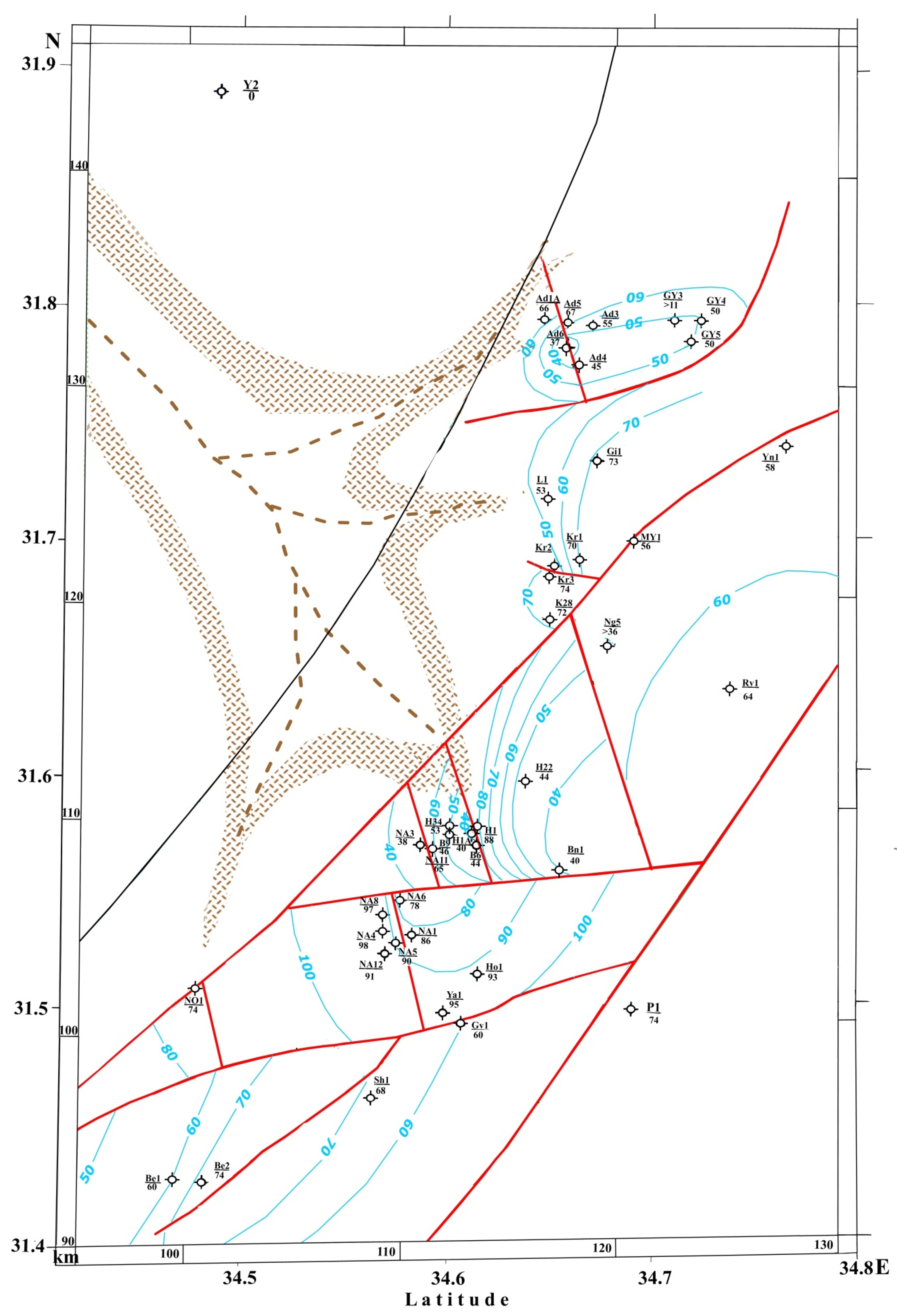
4.8. Geophysical Data Analysis
For clarifying the structural and geodynamic characteristics of the study area, results of different geophysical mapping were used [
7,
13,
14,
17,
29,
34,
37].
The structural heterogeneity of hydrocarbon deposits is due to both tectonic-sedimentary and facies, causing the depth and physical nature to differ. This has been identified in and around this area by a variety of geological and geophysical survey methods [
6,
7,
12,
13,
14,
17,
29,
30,
32,
34,
38,
49,
51]. As a result of combined structural analysis of syn-sedimentation sequence and gravity-magnetic mapping, a tectonic-geophysical scheme of the junction zone of the Pleshet, Heletz, and Negev terranes was compiled (
Figure 13).
Figure 13.
Combined gravity-magnetic map overlaid on the Late Jurassic-Early Cretaceous paleotectonic structure of the Heletz–Ashdod oil field and adjacent areas (revised after [
7]). (1) Bouguer anomalies isolines (in mGal), (2) isolines of magnetic anomalies (in nT), (3) isopach 800 m of the Middle-Upper Jurassic rocks in the Pleshet terrane, (4) isopach 1300 m of the Middle-Upper Jurassic rocks in the Heletz terrane, (5) faults. The gravity and magnetic maps were constructed using the Gravity-Magnetic DB of Israel [
37].
The Negev terrane is represented only by the northeastern margin adjacent to the narrow Heletz terrane. However, according to the gravity field distribution, the northwestern limb of the terrane is very gentle and undifferentiated, which is relatively consistent with the geological data. The magnetic field isolines, in general, also do not indicate any significant structural inhomogeneity in the considered Negev terrane margin. The gravity-magnetic data in the Heletz terrane shows an entirely different picture. They clearly trace all the tectonic blocks identified here: the Yinnon, Yakhini, and Gevim uplifts interspersed with submerged blocks—the Heletz triangle and Beeri.
In the zone of tectonic contact of the Heletz and Pleshet terranes, there is a sharp change in the nature of the distribution of isolines of gravity-magnetic changes, indicating a significant structural homogeneity of the Pleshet terrane, in which, according to gravity data, the Talme Yafo flat uplift is distinguished. The magnetic survey data located across the strike of the elongated axis of the Talme Jafe Rise contrast very interestingly with this pattern. The isolines of the magnetic field, branching off from the Heletz triangle, pass along the northeastern flank of this brachifold, crossing the isolines of the gravitational field at an angle of about 90 degrees.
This situation is fully consistent with the Heletz erosional canyon map (
Figure 7). It is very likely that the wide development of ferruginous minerals in the terrigenous sequence of the Lower Cretaceous canyon, revealed in the Heletz oil field [
42], is even more developed than in the canyon itself in the Pleshet terrane. This factor could affect the nature of the distribution of magnetic field isolines.
According to thermal field analysis [
34], the Curie surface depth is the most uplifted in the easternmost Mediterranean. This fact indicates that the Earth’s crust under the Heletz structure is the more heated.
Seismic data analysis (preliminary interpretation was carried out using Multifocusing Technology [
13]) also testifies the complex structure of the Heletz field. Of course, additional seismic studies are required here.


