

Evolution of the Po–Alpine River System during the Last 45 Ky Inferred from Stratigraphic and Compositional Evidence (Ostiglia, Northern Italy)


Abstract
:1. Introduction
2. Background
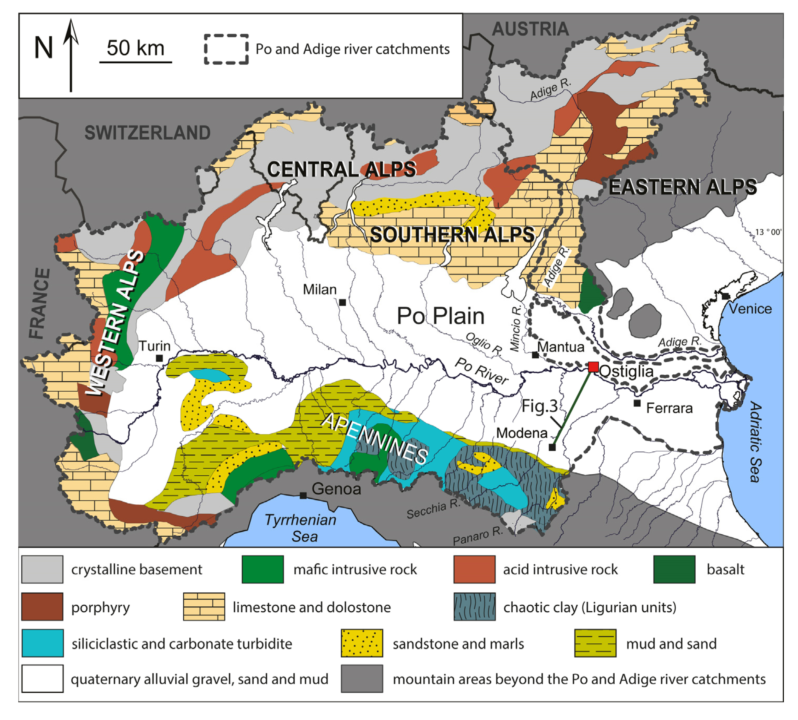
2.1. The Po Basin
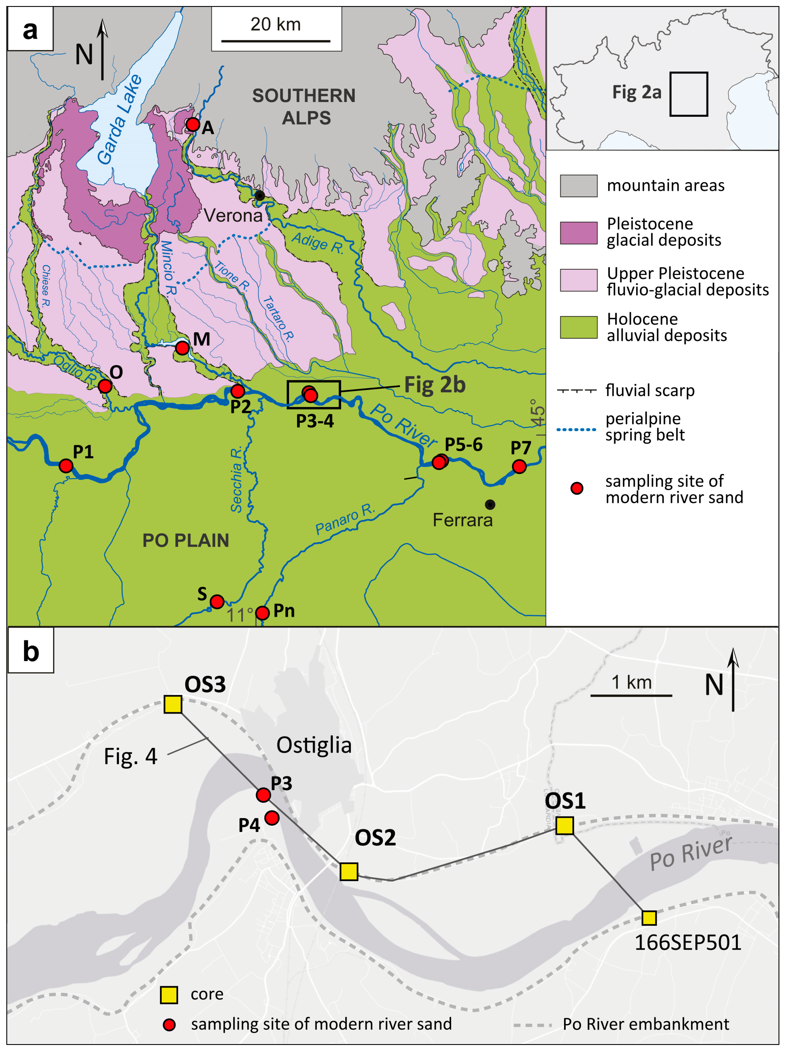
2.2. The Po Drainage System
3. Materials and Methods
4. Results
4.1. Facies Associations
4.1.1. Fluvial Channel (Fc)
4.1.2. Crevasse and Levee (CL)
4.1.3. Swamp (SW)
4.1.4. Poorly Drained Floodplain (PDF)
4.1.5. Well-Drained Floodplain (WDF)
4.1.6. Anthropogenic Deposits
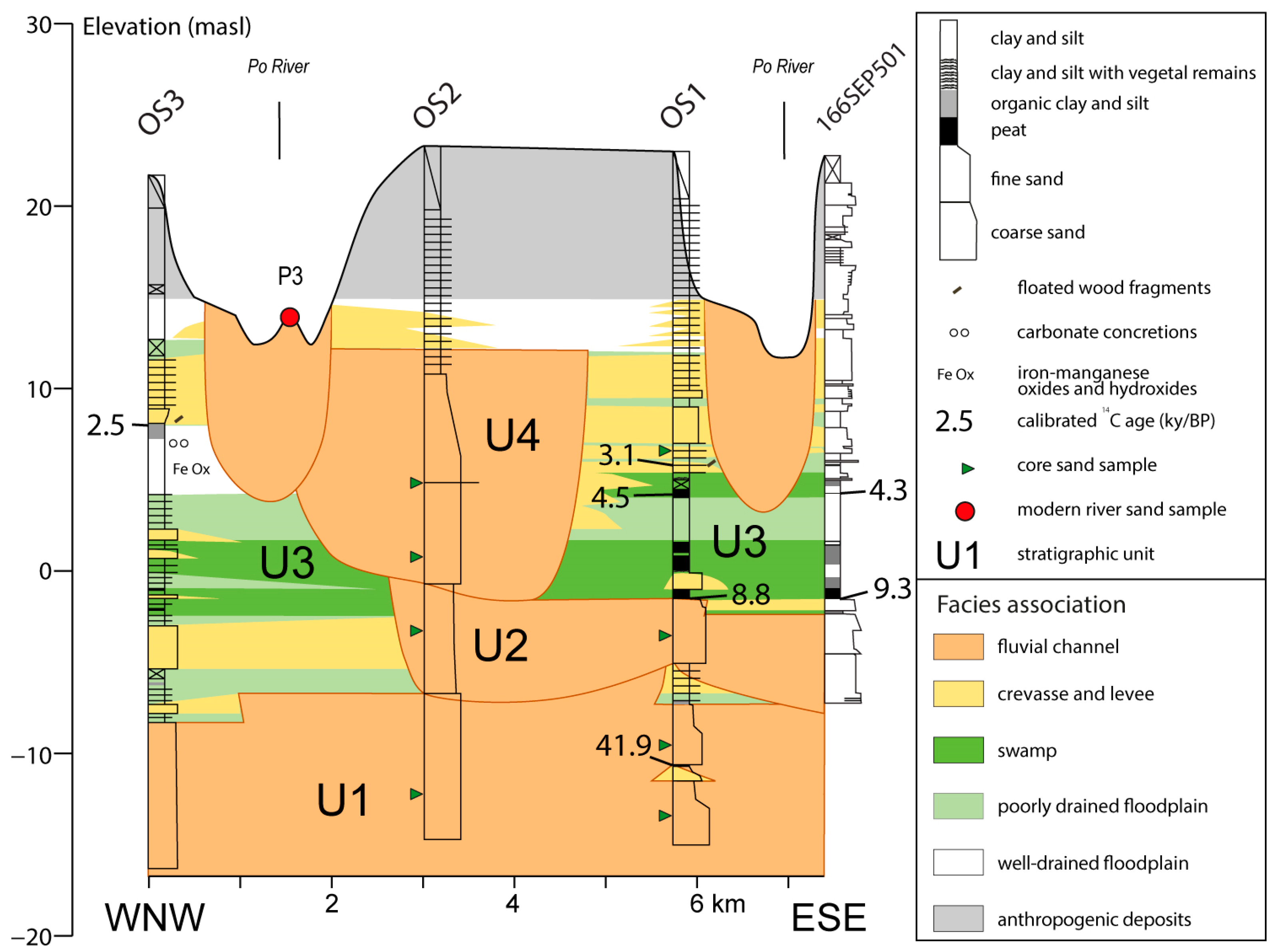
4.2. Stratigraphy of Cores OS1, OS2 and OS3
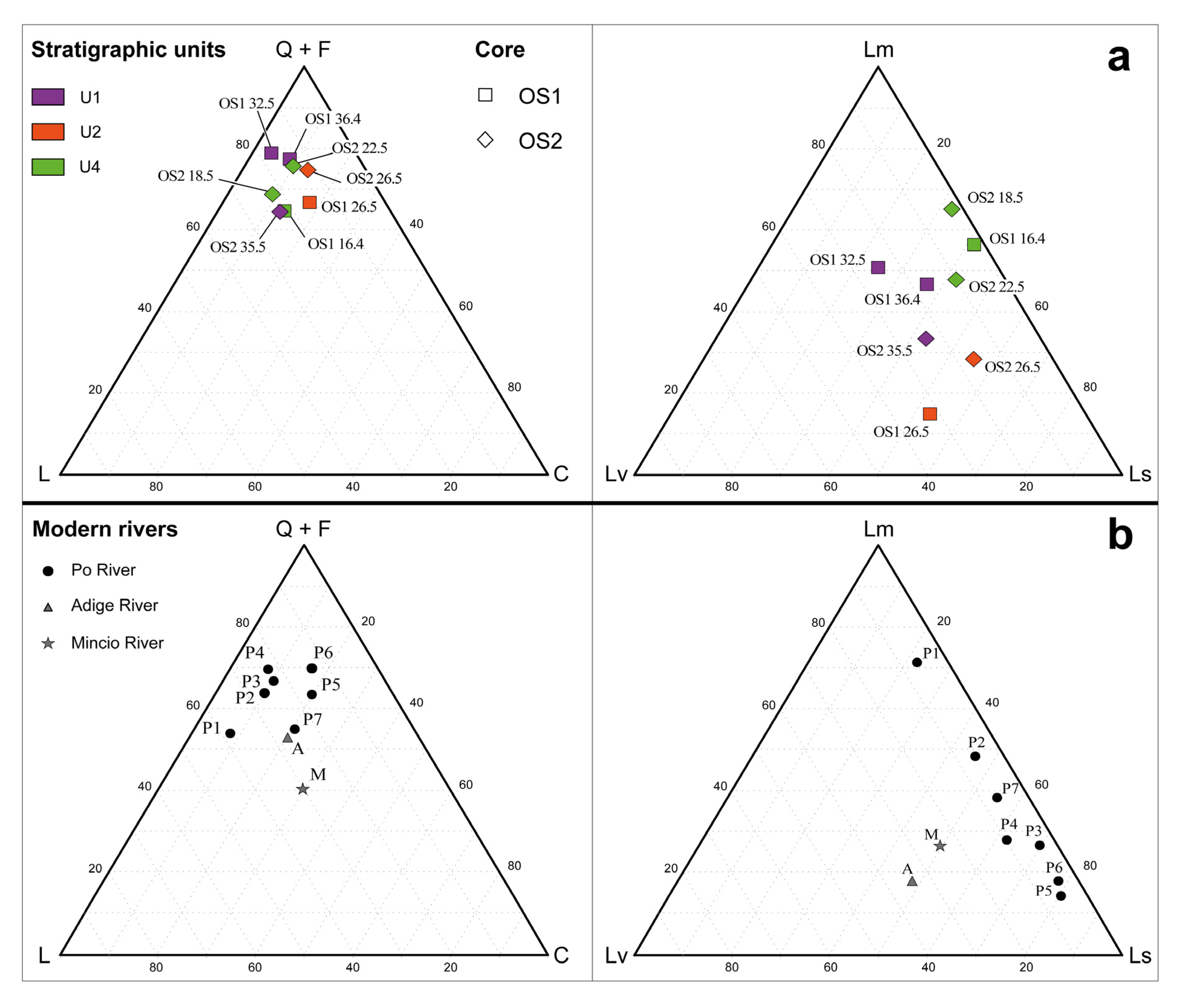
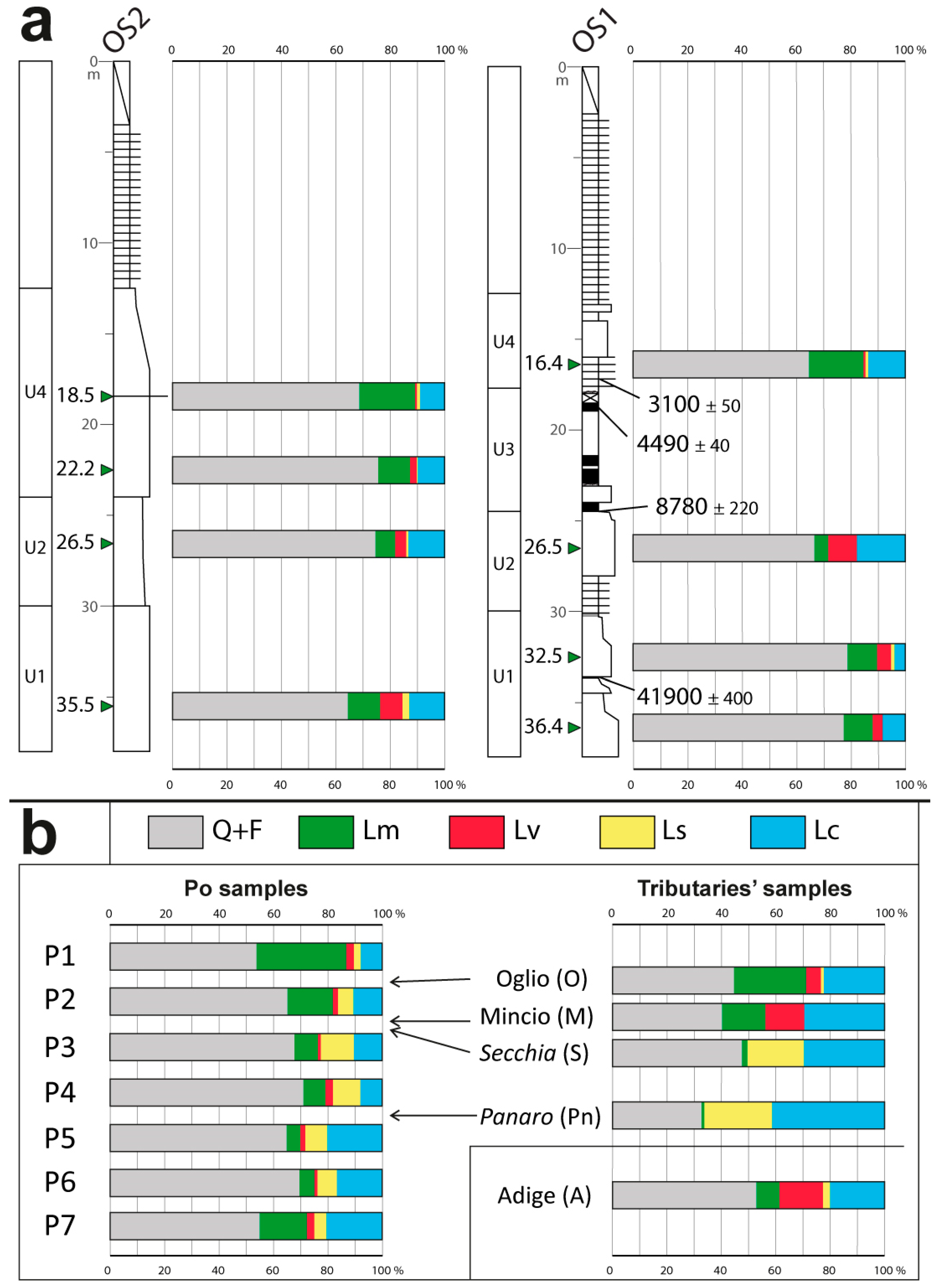
4.3. Sand Petrography
4.3.1. Core Sands
4.3.2. Modern River Sands
5. Discussion
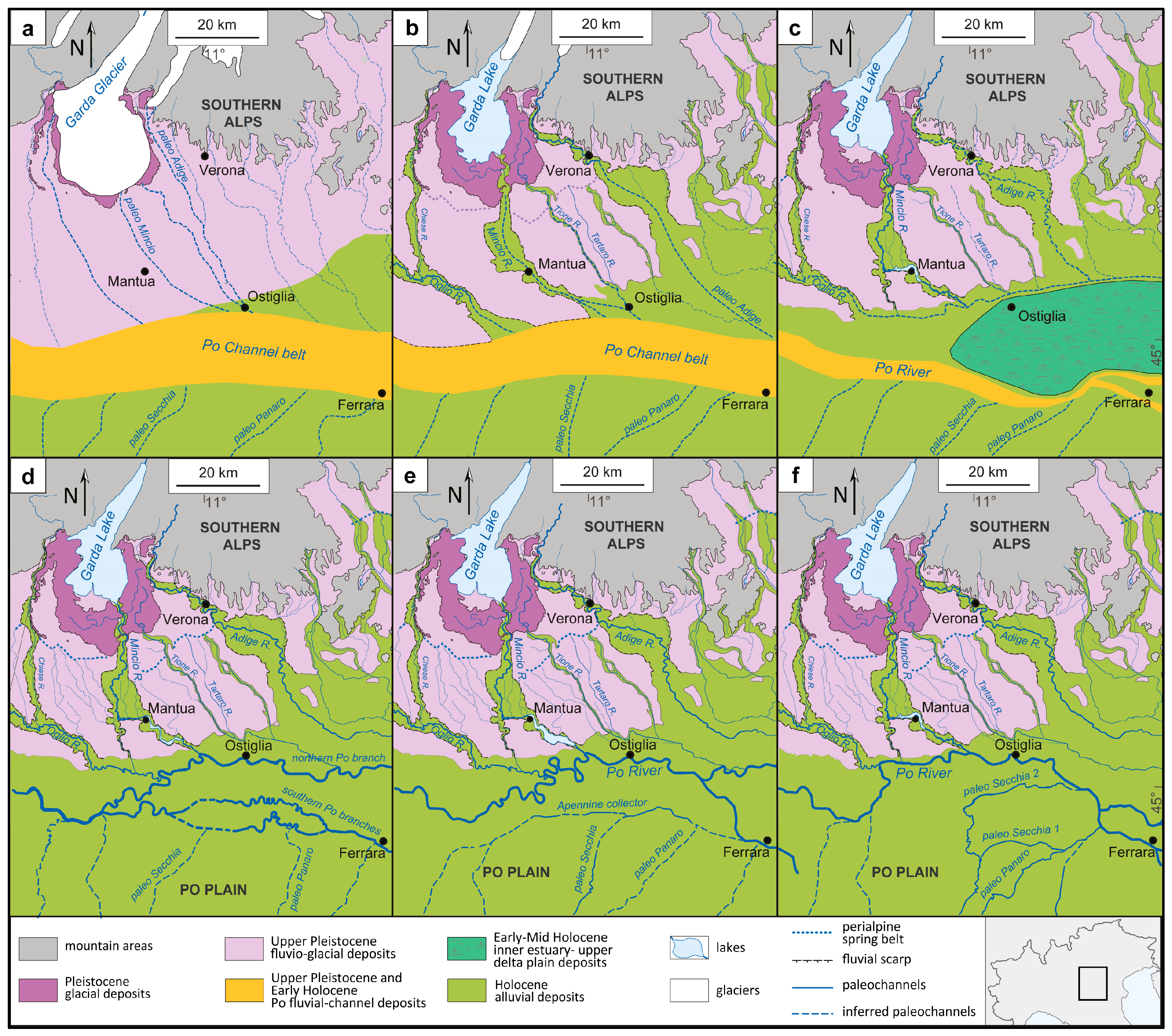
6. Conclusions
Author Contributions
Funding
Institutional Review Board Statement
Informed Consent Statement
Data Availability Statement
Acknowledgments
Conflicts of Interest
References
- Singh, S.K.; Rai, S.K.; Krishnaswami, S. Sr and Nd isotopes in river sediments from the Ganga Basin: Sediment provenance and spatial variability in physical erosion. J. Geophys. Res. 2008, 113, F03006. [Google Scholar] [CrossRef]
- Sinha, R.; Gibling, M.R.; Kettanah, Y.; Tandon, S.K.; Bhattacharja, P.S.; Dasgupta, A.S.; Ghazanfari, P. Craton-derived alluvium as a major sediment source in the Himalayan Foreland Basin of India. Geol. Soc. Am. Bull. 2009, 121, 1596–1610. [Google Scholar] [CrossRef]
- Tentori, D.; Milli, S.; Marsaglia, K.M. A source-to-sink compositional model of a present highstand: An example in the low-rank Tiber depositional sequence (Latium tyrrhenian margin, Italy). J. Sediment. Res. 2018, 88, 1238–1259. [Google Scholar] [CrossRef]
- Marcolla, A.; Monegato, G.; Mozzi, P.; Miola, A.; Stefani, C. Seesaw longitudinal–transverse drainage patterns driven by Middle and Late Pleistocene climate cycles in the foreland basin of the south-eastern European Alps. Sediment. Geol. 2021, 421, 105960. [Google Scholar] [CrossRef]
- Garzanti, E.; Vezzoli, G.; Andò, S. Paleogeographic and paleodrainage changes during Pleistocene glaciations (Po Plain, Northern Italy). Earth Sci. Rev. 2011, 105, 25–48. [Google Scholar] [CrossRef]
- Tentori, D.; Amorosi, A.; Milli, S.; Marsaglia, K.M. Sediment dispersal pathways in the Po coastal plain since the Last Glacial Maximum: Provenance signals of autogenic and eustatic forcing. Basin Res. 2021, 33, 1407–1428. [Google Scholar] [CrossRef]
- Rittenour, T.M. Dates and Rates of Earth-Surface Processes Revealed using Luminescence Dating. Elements 2018, 14, 21–26. [Google Scholar] [CrossRef]
- Molodkov, A. The Late Pleistocene palaeoenvironmental evolution in Northern Eurasia through the prism of the mollusc shell-based ESR dating evidence. Quat. Int. 2020, 556, 180–197. [Google Scholar] [CrossRef]
- Reimer, P.; Austin, W.; Bard, E.; Bayliss, A.; Blackwell, P.; Bronk Ramsey, C.; Butzin, M.; Cheng, H.; Edwards, R.; Friedrich, M.; et al. The IntCal20 Northern Hemisphere radiocarbon age calibration curve (0–55 cal kBP). Radiocarbon 2020, 62, 725–757. [Google Scholar] [CrossRef]
- Castiglioni, G.B.; Ajassa, R.; Baroni, C.; Biancotti, A.; Bondesan, A.; Brancucci, G.; Castaldini, D.; Castellaccio, E.; Cavallin, A.; Cortemiglia, F.; et al. Geomorphological Map of Po Plain, 3 Sheets, Scale 1:250,000; MURST–S.El.Ca: Firenze, Italy, 1997. [Google Scholar]
- Correggiari, A.; Cattaneo, A.; Trincardi, F. The modern Po Delta system: Lobe switching and asymmetric prodelta growth. Mar. Geol. 2005, 222–223, 49–74. [Google Scholar] [CrossRef]
- Morelli, A.; Bruno, L.; Cleveland, D.M.; Drexler, T.M.; Amorosi, A. Reconstructing Last Glacial Maximum and Younger Dryas paleolandscapes through subsurface paleosol stratigraphy: An example from the Po coastal plain, Italy. Geomorphology 2017, 295, 790–800. [Google Scholar] [CrossRef]
- Fontana, D.; Amoroso, S.; Minarelli, L.; Stefani, M. Sand liquefaction phenomena induced by a blast test: New insights from composition and texture of sands (late Quaternary, Emilia, Italy). J. Sediment. Res. 2019, 89, 13–27. [Google Scholar] [CrossRef]
- Bruno, L.; Amorosi, A.; Lugli, S.; Sammartino, I.; Fontana, D. Trunk river and tributary interactions recorded in the Pleistocene–Holocene stratigraphy of the Po Plain (northern Italy). Sedimentology 2021, 68, 2918–2943. [Google Scholar] [CrossRef]
- Turrini, C.; Toscani, G.; Lacombe, O.; Roure, F. Influence of structural inheritance on foreland-foredeep system evolution: An example from the Po valley region (northern Italy). Mar. Pet. Geol. 2016, 77, 376–398. [Google Scholar] [CrossRef]
- Carminati, E.; Doglioni, C. Alps vs. Apennines: The Paradigm of a Tectonically Asymmetric Earth. Earth Sci. Rev. 2012, 112, 67–96. [Google Scholar] [CrossRef]
- Carminati, E.; Di Donato, G. Separating natural and anthropogenic vertical movements in fast subsiding areas: The Po Plain (N. Italy) Case. Geophys. Res. Lett. 1999, 26, 2291–2294. [Google Scholar] [CrossRef]
- Antonioli, F.; Ferranti, L.; Fontana, A.; Amorosi, A.; Bondesan, A.; Braitenberg, C.; Dutton, A.; Fontolan, G.; Furlani, S.; Lambeck, K.; et al. Holocene relative sea-level changes and vertical movements along the Italian and Istrian coastlines. Quat. Int. 2009, 206, 102–133. [Google Scholar] [CrossRef]
- Bruno, L.; Campo, B.; Costagli, B.; Stouthamer, E.; Teatini, P.; Zoccarato, C.; Amorosi, A. Factors Controlling Natural Subsidence in the Po Plain. Proc. Int. Assoc. Hydrol. Sci. 2020, 382, 285–290. [Google Scholar] [CrossRef]
- Amadori, C.; Toscani, G.; Di Giulio, A.; Maesano, F.E.; D’Ambrogi, C.; Ghielmi, M.; Fantoni, R. From Cylindrical to Non-Cylindrical Foreland Basin: Pliocene–Pleistocene Evolution of the Po Plain–Northern Adriatic Basin (Italy). Basin Res. 2019, 31, 991–1015. [Google Scholar] [CrossRef]
- Muttoni, G.; Carcano, C.; Garzanti, E.; Ghielmi, M.; Piccin, A.; Pini, R.; Rogledi, S.; Sciunnach, D. Onset of major Pleistocene glaciations in the Alps. Geology 2003, 31, 989–992. [Google Scholar] [CrossRef]
- Muttoni, G.; Scardia, G.; Kent, D.V.; Morsiani, E.; Tremolada, F.; Cremaschi, M.; Peretto, C. First dated human occupation of Italy at ~0.85 Ma during the late Early Pleistocene climate transition. Earth Planet. Sci. Lett. 2011, 307, 241–252. [Google Scholar] [CrossRef]
- Scardia, G.; Muttoni, G.; Sciunnach, D. Subsurface magnetostratigraphy of Pleistocene sediments from the Po Plain (Italy): Constraints on rates of sedimentation and rock uplift. Geol. Soc. Am. Bull. 2006, 118, 1299–1312. [Google Scholar] [CrossRef]
- Gunderson, K.L.; Pazzaglia, F.J.; Picotti, V.; Anastasio, D.A.; Kodama, K.P.; Rittenou, R.T.; Frankel, K.F.; Ponza, A.; Berti, C.; Negri, A.; et al. Unraveling tectonic and climatic controls on synorogenic growth strata (Northern Appennines, Italy). Geol. Soc Am. Bull. 2014, 126, 532–552. [Google Scholar] [CrossRef]
- Bruno, L.; Piccin, A.; Sammartino, I.; Amorosi, A. Decoupled geomorphic and sedimentary response of Po River and its Alpine tributaries during the last glacial/post-glacial episode. Geomorphology 2018, 317, 184–198. [Google Scholar] [CrossRef]
- Campo, B.; Amorosi, A.; Bruno, L. Contrasting alluvial architecture of late Pleistocene and Holocene deposits along a 120-km transect from the central Po Plain (northern Italy). Sediment. Geol. 2016, 341, 265–275. [Google Scholar] [CrossRef]
- Fontana, A.; Mozzi, P.; Marchetti, M. Alluvial fans and megafans along the southern side of the Alps. Sediment. Geol. 2014, 301, 150–171. [Google Scholar] [CrossRef]
- Bronk Ramsey, C.; Lee, S. Recent and planned developments of the program OxCal. Radiocarbon 2013, 55, 720–730. [Google Scholar] [CrossRef]
- Lugli, S.; Marchetti Dori, S.; Fontana, D.; Panini, F. Composition of sands in cores along the high-speed rail (TAV): Preliminary indications on the sedimentary evolution of the Modena plain. Alpine Mediterran. Quatern. 2004, 17, 379–390. [Google Scholar]
- Lugli, S.; Marchetti Dori, S.; Fontana, D. Alluvial sand composition as a tool to unravel the Late Quaternary sedimentation of the Modena plain, northern Italy. In Sedimentary Provenance and Petrogenesis: Perspectives from Petrography and Geochemistry; Arribas, J., Critelli, S., Johnsson, M.J., Eds.; Geological Society of America, Special Paper: Boulder, CO, USA, 2007; Volume 420, pp. 57–72, ISBN-13 978-0-8137-2420-1. [Google Scholar] [CrossRef]
- Zuffa, G.G. (Ed.) Optical analyses of arenites: Influence of methodology on compositional results. In Provenance of Arenites; D. Reidel, NATO Advanced Study Institute: Dordrecht, Nederland, 1985; Volume 148, pp. 165–189. [Google Scholar]
- Garzanti, E.; Ando, S.; Vezzoli, G. Settling equivalence of detrital minerals and grain-size dependence of sediment composition. Earth Planet. Sci. Lett. 2008, 273, 138–151. [Google Scholar] [CrossRef]
- Weltje, G.J. A quantitative approach to capturing the compositional variability of modern sands. Sed. Geol. 2004, 171, 59–77. [Google Scholar] [CrossRef]
- Razum, I.; Lužar-Oberiter, B.; Zaccarini, F.; Babić, L.; Miko, S.; Hasan, O.; Ilijanić, N.; Beqiraj, E.; Pawlowsky-Glahn, V. New sediment provenance approach based on orthonormal log ratio transformation of geochemical and heavy mineral data: Sources of eolian sands from the southeastern Adriatic archipelago. Chem. Geol. 2021, 583, 120451. [Google Scholar] [CrossRef]
- Allen, J.R.L. The classification of cross-stratified units with notes on their origin. Sedimentology 1963, 2, 93–114. [Google Scholar] [CrossRef]
- Diessel, C.F.K. Coal facies and depositional environment. In Coal-Bearing Depositional Systems; Springer: Berlin/Heidelberg, Germany, 1992; pp. 161–264. [Google Scholar] [CrossRef]
- Stolt, M.H.; Rabenhorst, M.C. Introduction and historical development of subaqueous soil concepts. In Handbook of Soil Sciences Properties and Processes; Huang, P.M., Li, Y., Sumner, M.L., Eds.; CRC Press, LLC: Boca Raton, FL, USA, 2011; ISBN 978-1-4398-0305-9. [Google Scholar] [CrossRef]
- Ravazzi, C.; Pini, R.; Badino, F.; De Amicis, M.; Londeix, L.; Reimer, P.J. The latest LGM culmination of the Garda Glacier (Italian Alps) and the onset of glacial termination. Age of glacial collapse and vegetation chronosequence. Quat. Sci. Rev. 2014, 105, 26–47. [Google Scholar] [CrossRef]
- Ishii, Y.; Hori, K.; Momohara, A.; Nakanishi, T.; Hong, W. Middle to late-Holocene decreased fluvial aggradation and widespread peat initiation in the Ishikari lowland (northern Japan). Holocene 2016, 26, 1924–1938. [Google Scholar] [CrossRef]
- Bruno, L.; Campo, B.; Di Martino, A.; Hong, W.; Amorosi, A. Peat layer accumulation and post-burial deformation during the mid-late Holocene in the Po coastal plain (Northern Italy). Basin Res. 2019, 31, 621–639. [Google Scholar] [CrossRef]
- Rossi, V.; Amorosi, A.; Barbieri, G.; Vaiani, S.C.; Germano, M.; Campo, B. A Long-Term Record of Quaternary Facies Patterns and Palaeonvironmental Trends from the Po Plain (NE Italy) as Revealed by Bio-Sedimentary Data. Geosciences 2021, 11, 401. [Google Scholar] [CrossRef]
- Balista, C. Geoarcheologia dell’area terramaricola al confine fra le province di Modena, Mantova e Ferrara. In Atlante dei Beni Archeologici della Provincia di Modena; Cardarelli, A., Malnati, L., Eds.; Edizioni all’Insegna del Giglio s.a.s: Sesto Fiorentino (FI), Italy, 2003; Volume 1, pp. 24–32. ISBN 88-7814-265-4. [Google Scholar]
- Amorosi, A.; Bruno, L.; Campo, B.; Morelli, A.; Rossi, V.; Scarponi, D.; Hong, W.; Bohacs, K.M.; Drexler, T.M. Global sea-level control on local parasequence architecture from the Holocene record of the Po Plain, Italy. Mar. Pet. Geol. 2017, 87, 99–111. [Google Scholar] [CrossRef]
- Bruno, L.; Bohacs, K.M.; Campo, B.; Drexler, T.M.; Rossi, V.; Sammartino, I.; Amorosi, A. Early Holocene transgressive paleogeography in the Po coastal plain (Northern Italy). Sedimentology 2017, 64, 1792–1816. [Google Scholar] [CrossRef]
- Ravazzi, C.; Marchetti, M.; Zanon, M.; Perego, R.; Quirino, T.; Deaddis, M.; De Amicis, M.; Margaritora, D. Lake evolution and landscape history in the lower Mincio River valley, unravelling drainage changes in the central Po Plain (N-Italy) since the Bronze Age. Quat. Int. 2013, 288, 195–205. [Google Scholar] [CrossRef]
- Veggiani, A. Il delta del Po e l’evoluzione della rete idrografica padana in epoca storica. In Atti della Tavola Rotonda su: Il delta del Po; Bologna 24 novembre 1982; Accademia delle Scienze dell’Istituto di Bologna: Bologna, Italy, 1985; pp. 37–68. [Google Scholar]
- Cremonini, S. Nuove osservazioni relative al “Dosso di Gavello” modenese. In Nuove ricerche sugli Etruschi; Gruppo studi Bassa Modenese: San Felice sul Panaro (Mo), Italy, 1993; pp. 149–159. [Google Scholar]
- Castaldini, D.; Giusti, C.; Marchetti, M. La Geomorfologia del corso del Po e del territorio nel tratto foce Enza-foce Oglio. In L’anima del Po. Terre acque e uomini tra Enza e Oglio; Venturi, S., Bacchi, N., Eds.; Battei: Parma, Italy, 2003; pp. 5–31. [Google Scholar]
- Castaldini, D.; Marchetti, M.; Cardarelli, A. Some notes on geomorphological and archaeological aspects in the central Po Plain (northern Italy). In Ol’man River. Geo-Archaeological Aspects of Rivers and River Plains; De Dapper, M., Vermeulen, F., Deprez, S., Taelman, D., Eds.; Ghent University, Akademia Press: Ghent, Belgium, 2009; pp. 193–212. ISBN 9038214049. [Google Scholar]
- Burrato, P.; Ciucci, F.; Valensise, G. An inventory of river anomalies in the Po Plain, Northern Italy: Evidence for active blind thrust faulting. Ann. Geophys. 2003, 46, 865–882. [Google Scholar] [CrossRef]
- Burrato, P.; Vannoli, P.; Fracassi, U.; Basili, R.; Valensise, G. Is blind faulting truly invisible? Tectonic-controlled drainage evolution in the epicentral area of the May 2012, Emilia-Romagna earthquake sequence (northern Italy). Ann. Geophys. 2012, 55, 525–531. [Google Scholar] [CrossRef]
- Castaldini, D.; Marchetti, M.; Norini, G.; Vandelli, V.; Vélez, M.C.Z. Geomorphology of the central Po Plain, Northern Italy. J. Maps 2019, 15, 780–787. [Google Scholar] [CrossRef]
- Cremaschi, M.; Mercuri, A.M.; Torri, P.; Florenzano, A.; Pizzi, C.; Marchesini, M.; Zerboni, A. Climate change versus land management in the Po Plain (Northern Italy) during the Bronze Age: New insights from the VP/VG sequence of the Terramara Santa Rosa di Poviglio. Quat. Sci. Rev. 2016, 136, 153–172. [Google Scholar] [CrossRef]


| Core | Lab | Material | Depth (m) | 14C Age | Calibrated Age (mean ± 2σ) | Lab Code |
|---|---|---|---|---|---|---|
| OS3 | KIGAM | soil | 13.7 | 2442 ± 25 | 2520 ± 220 | KGM-OSa200128 |
| OS1 | KIGAM | wood | 17.2 | 2949 ± 25 | 3100 ± 50 | KGM-OWd200614 |
| OS1 | KIGAM | peat | 18.8 | 4030 ± 26 | 4490 ± 40 | KGM-OWd200623 |
| OS1 | KIGAM | peat | 24.5 | 7924 ± 34 | 8780 ± 220 | KGM-OSa200130 |
| OS1 | KIGAM | peat | 33.6 | 37111 ± 245 | 41900 ± 400 | KGM-OSa200127 |
Publisher’s Note: MDPI stays neutral with regard to jurisdictional claims in published maps and institutional affiliations. |
© 2022 by the authors. Licensee MDPI, Basel, Switzerland. This article is an open access article distributed under the terms and conditions of the Creative Commons Attribution (CC BY) license (https://creativecommons.org/licenses/by/4.0/).
Share and Cite
Demurtas, L.; Bruno, L.; Lugli, S.; Fontana, D. Evolution of the Po–Alpine River System during the Last 45 Ky Inferred from Stratigraphic and Compositional Evidence (Ostiglia, Northern Italy). Geosciences 2022, 12, 342. https://doi.org/10.3390/geosciences12090342
Demurtas L, Bruno L, Lugli S, Fontana D. Evolution of the Po–Alpine River System during the Last 45 Ky Inferred from Stratigraphic and Compositional Evidence (Ostiglia, Northern Italy). Geosciences. 2022; 12(9):342. https://doi.org/10.3390/geosciences12090342
Chicago/Turabian StyleDemurtas, Luca, Luigi Bruno, Stefano Lugli, and Daniela Fontana. 2022. "Evolution of the Po–Alpine River System during the Last 45 Ky Inferred from Stratigraphic and Compositional Evidence (Ostiglia, Northern Italy)" Geosciences 12, no. 9: 342. https://doi.org/10.3390/geosciences12090342
APA StyleDemurtas, L., Bruno, L., Lugli, S., & Fontana, D. (2022). Evolution of the Po–Alpine River System during the Last 45 Ky Inferred from Stratigraphic and Compositional Evidence (Ostiglia, Northern Italy). Geosciences, 12(9), 342. https://doi.org/10.3390/geosciences12090342