


Should Anthropic Ridges Framed as Foredunes Be Considered Real Dunes?

 and
and
Abstract
1. Introduction
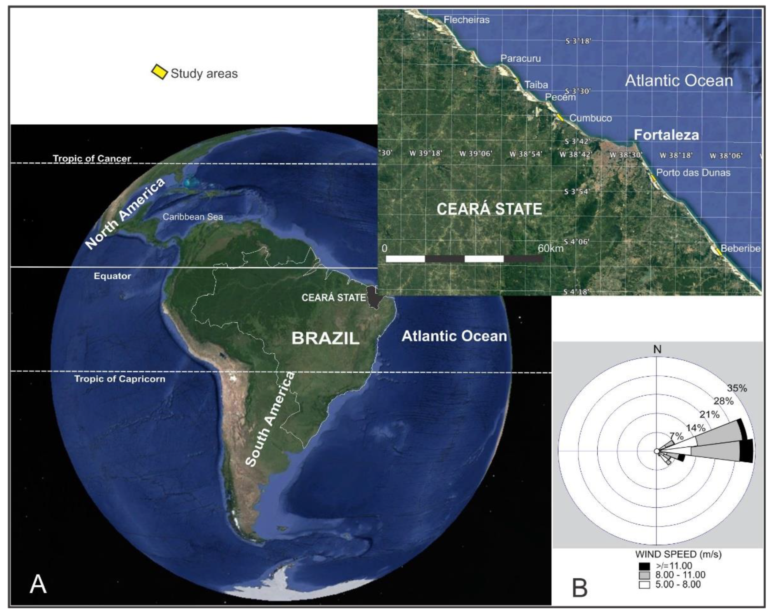
2. Study Area
2.1. Climatologic and Oceanographic Factors
2.2. Geology and Geomorphology
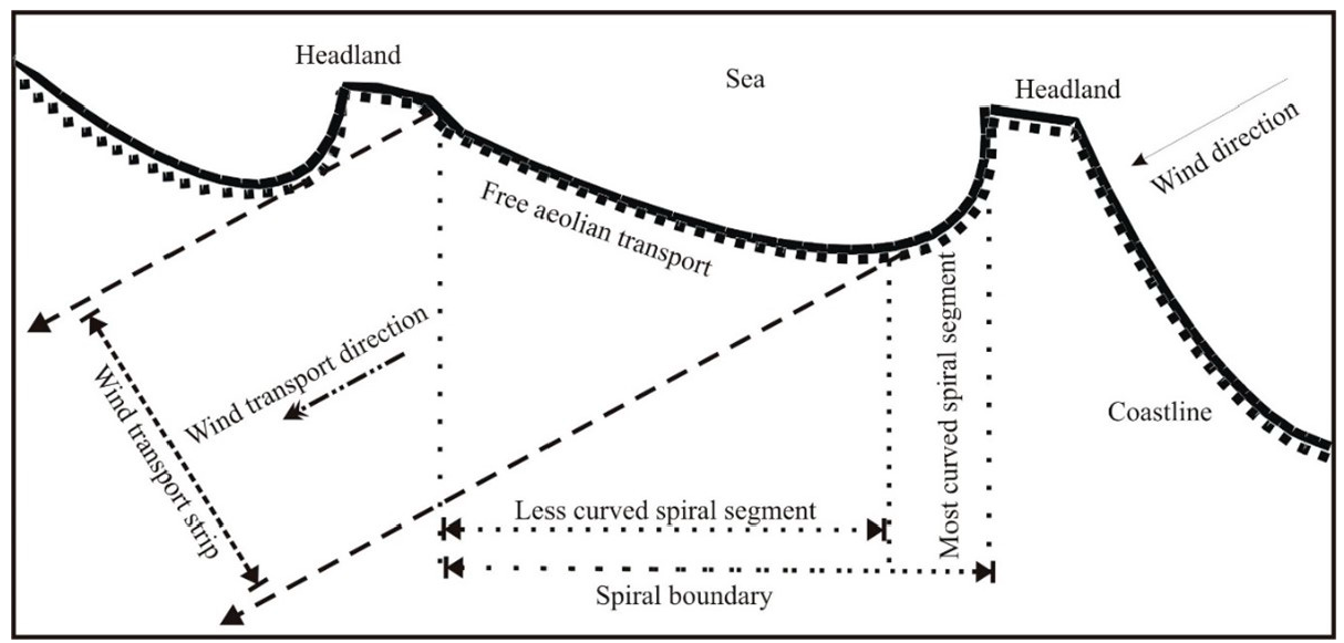
2.3. Coastal Dynamics
3. Methods
3.1. Ground Control Points (GCPs) Determination
3.2. Multitemporal Image Processing
3.3. UAV Data Acquisition and Analysis
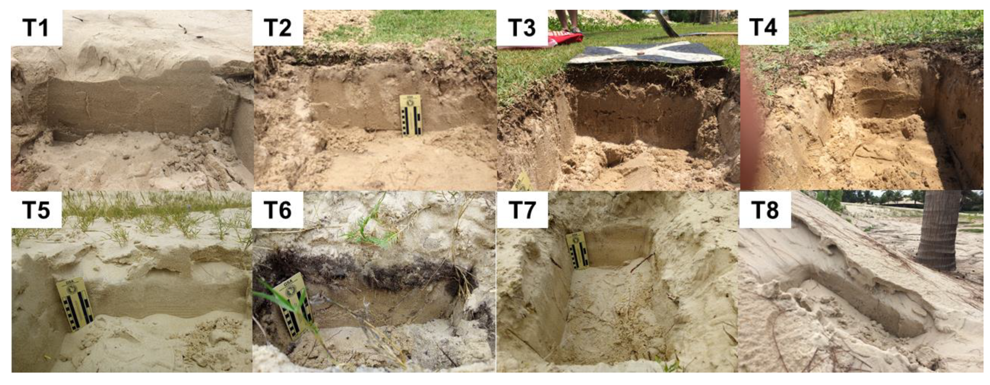
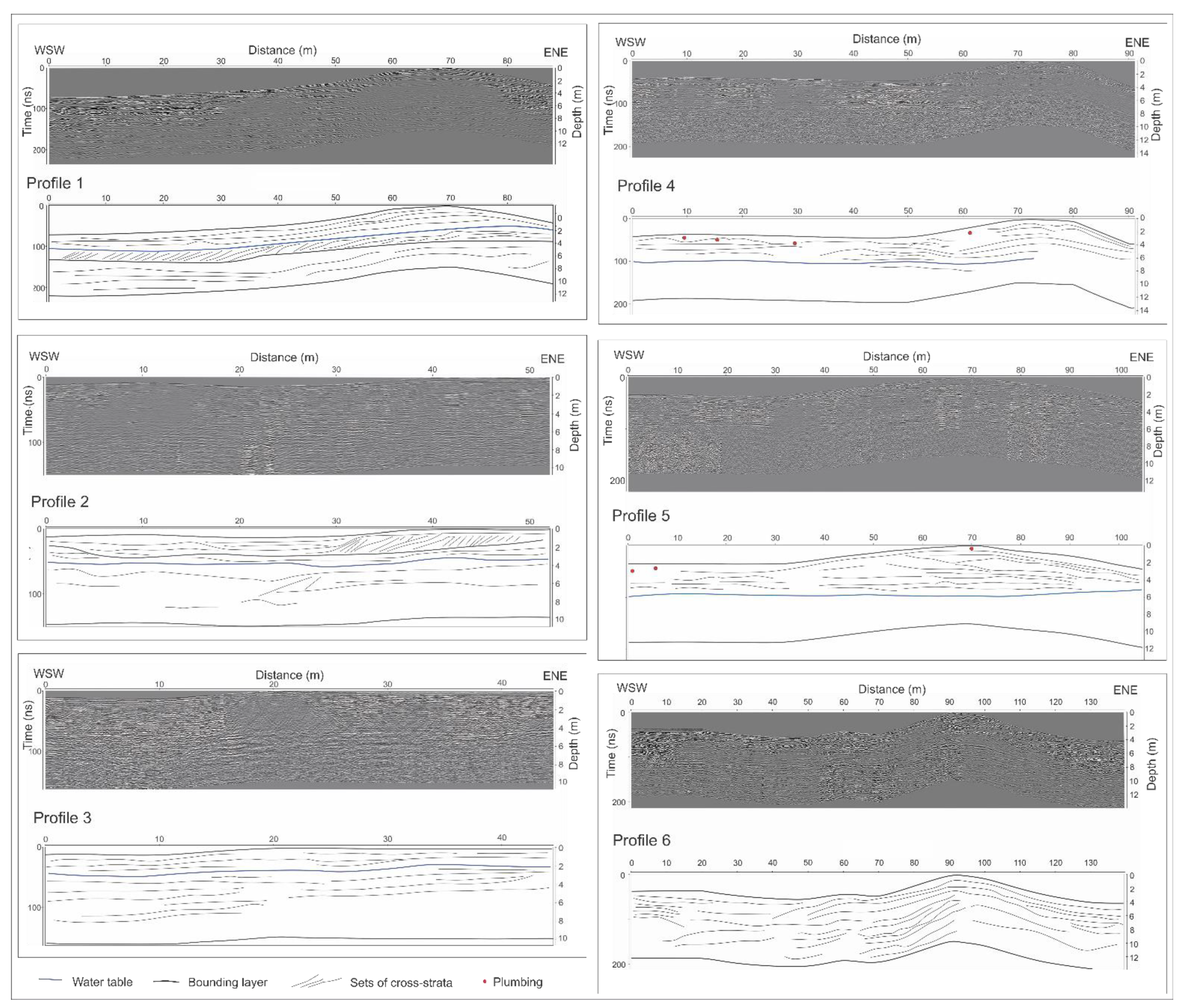
3.4. Internal Structure Using Trench and GPR
3.5. Particle Size Analysis
4. Results
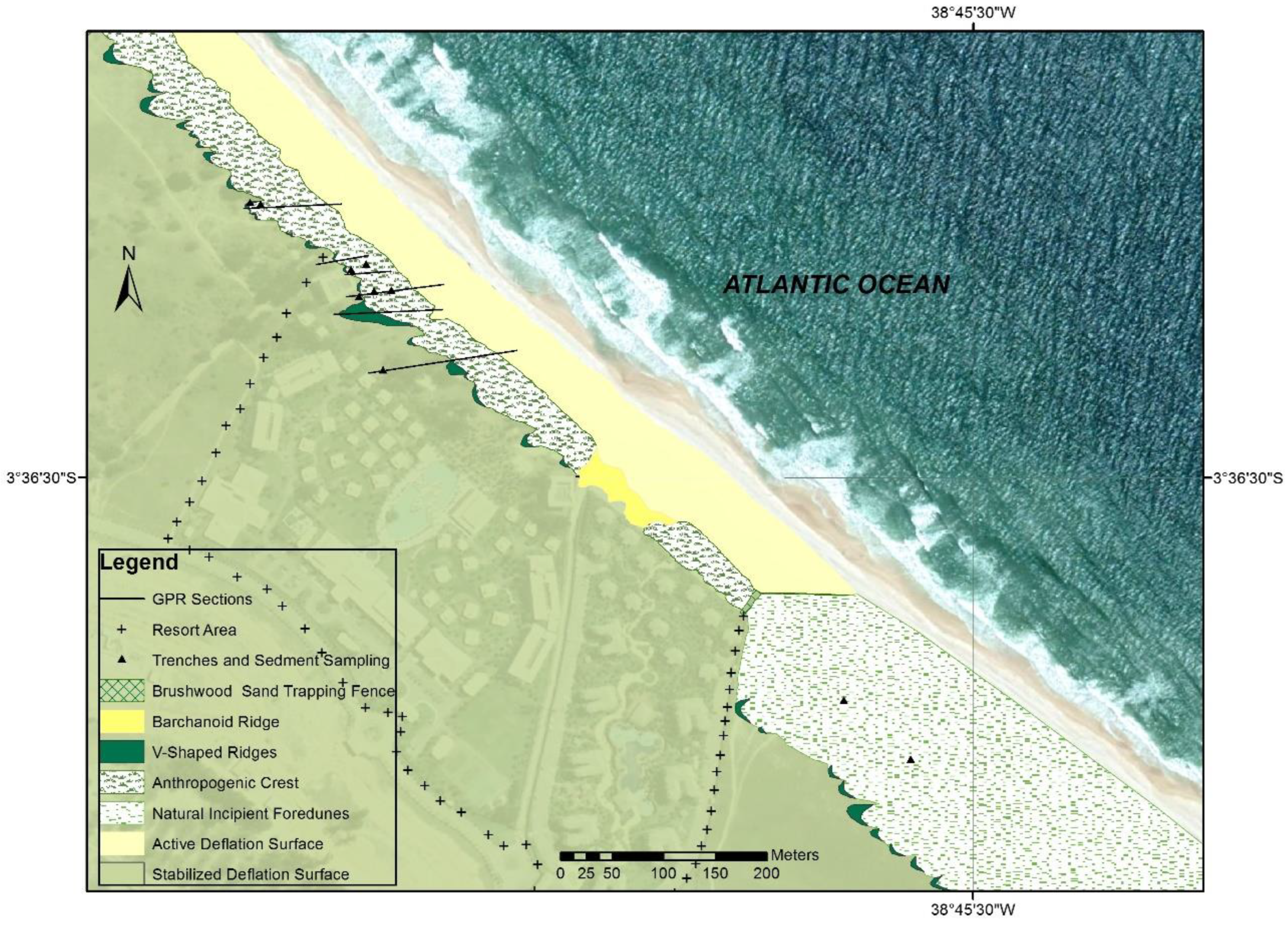
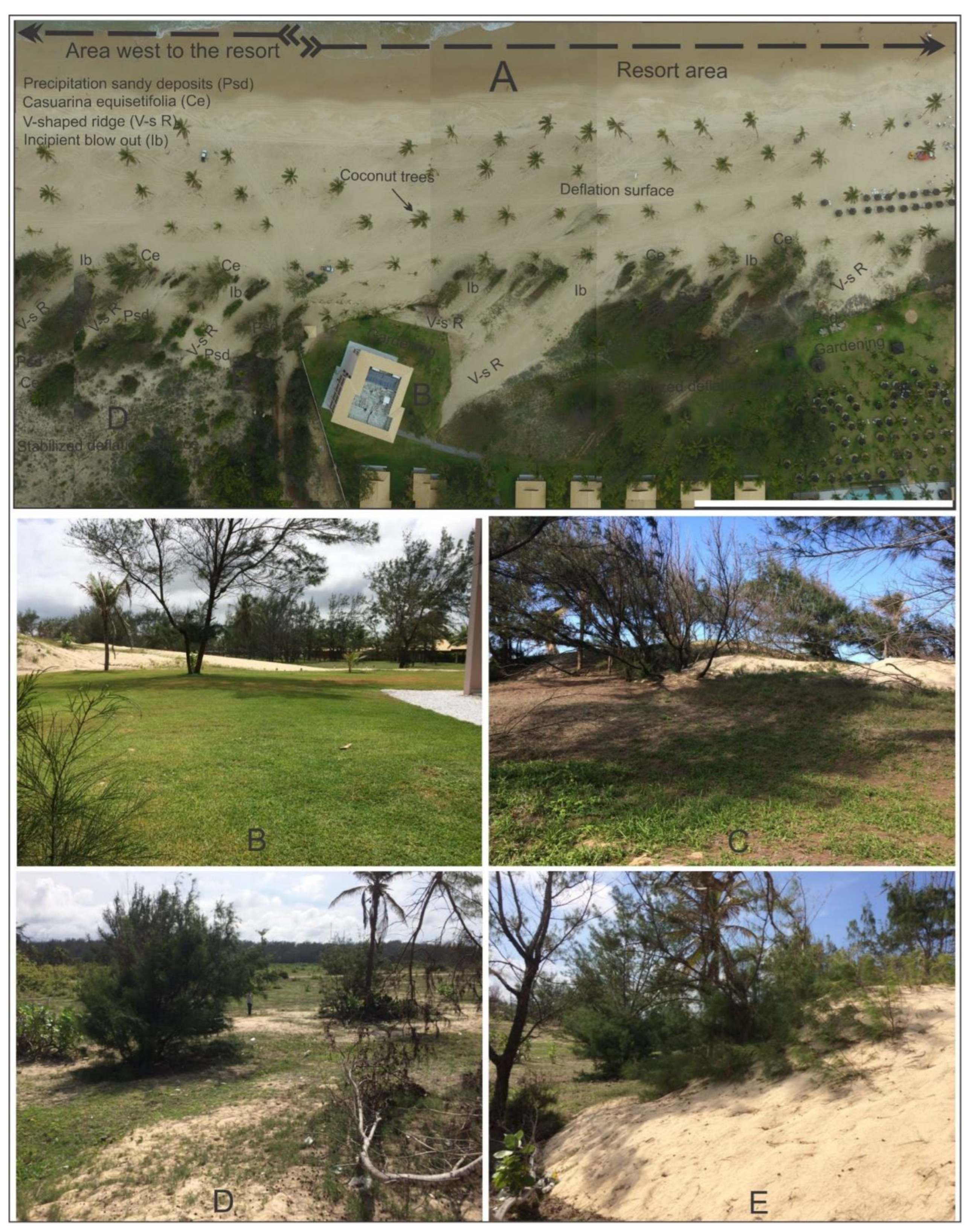
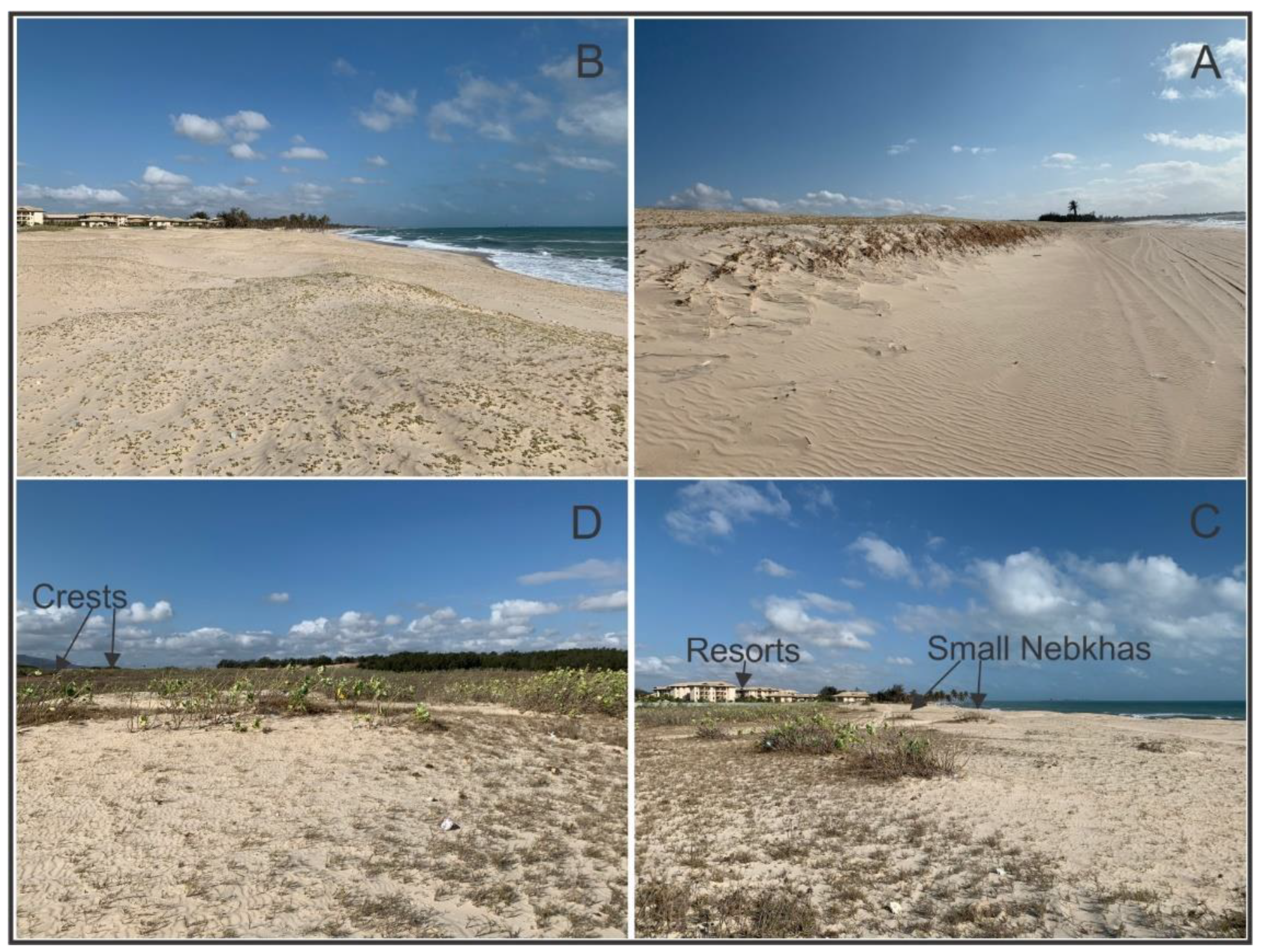
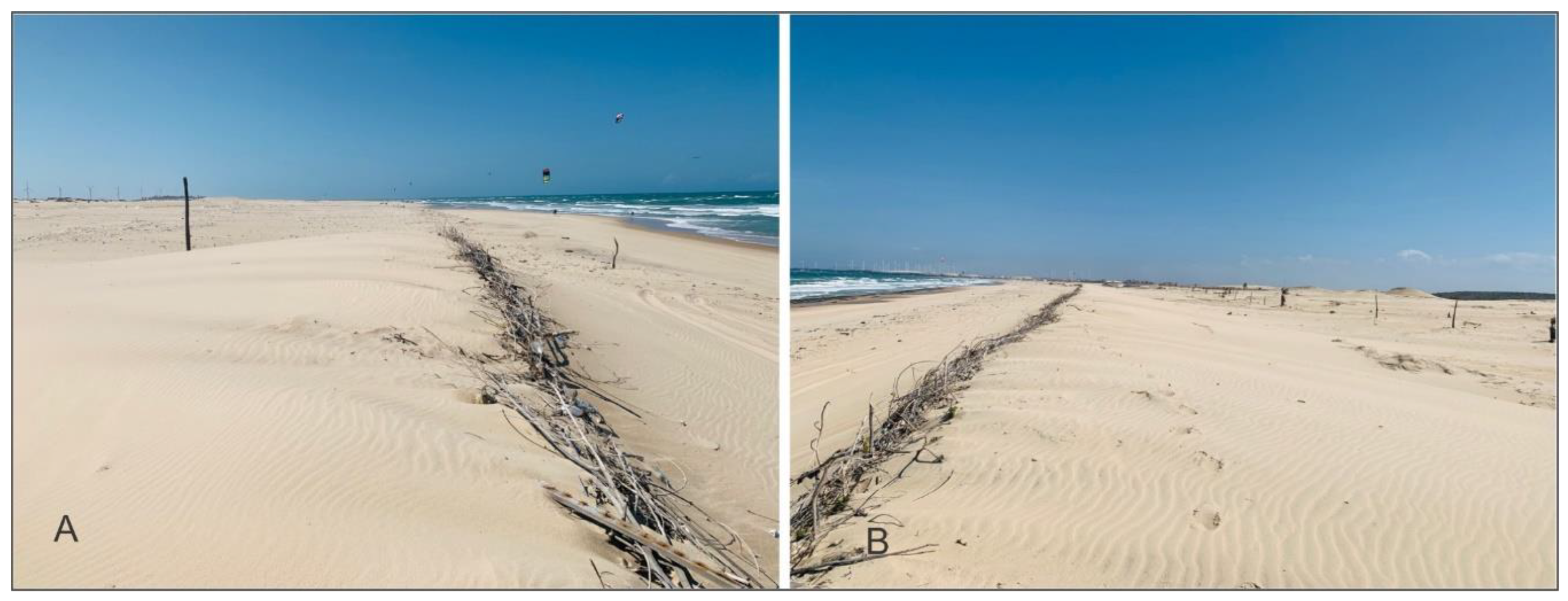
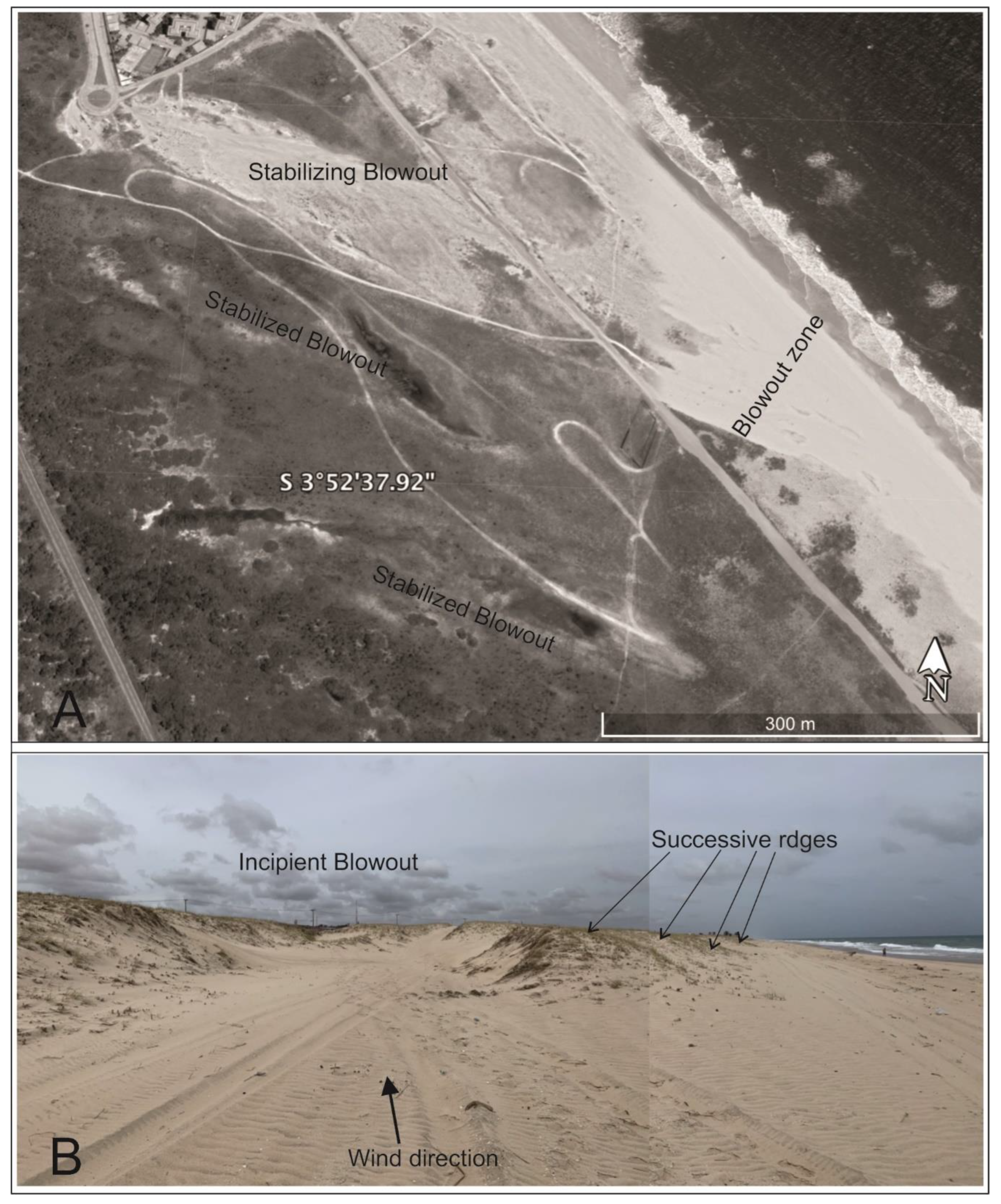
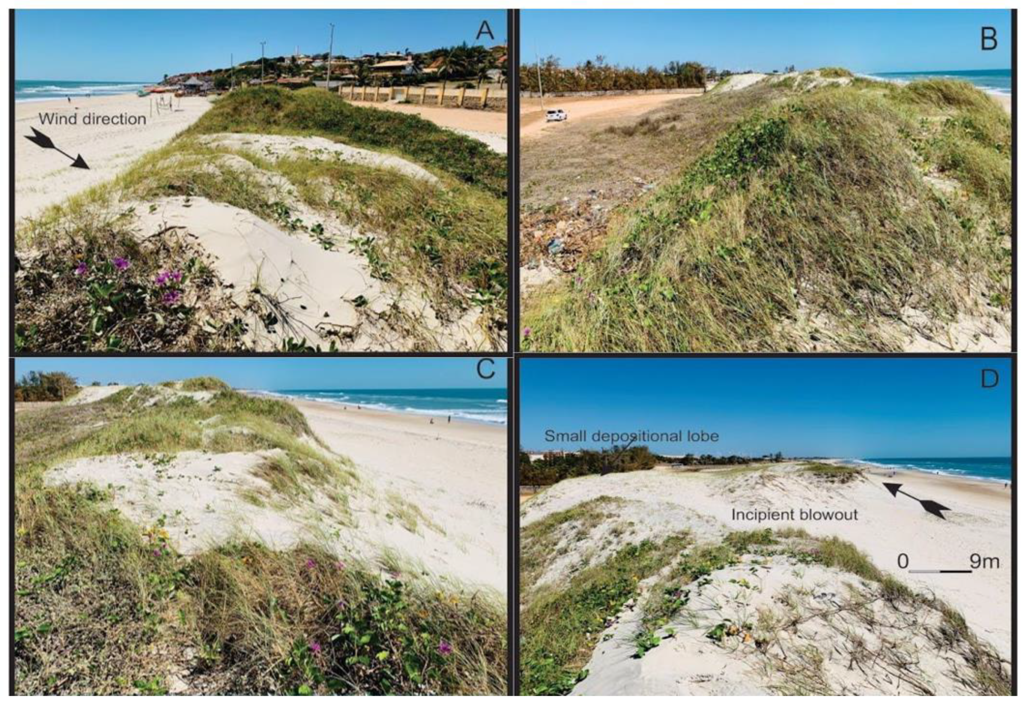
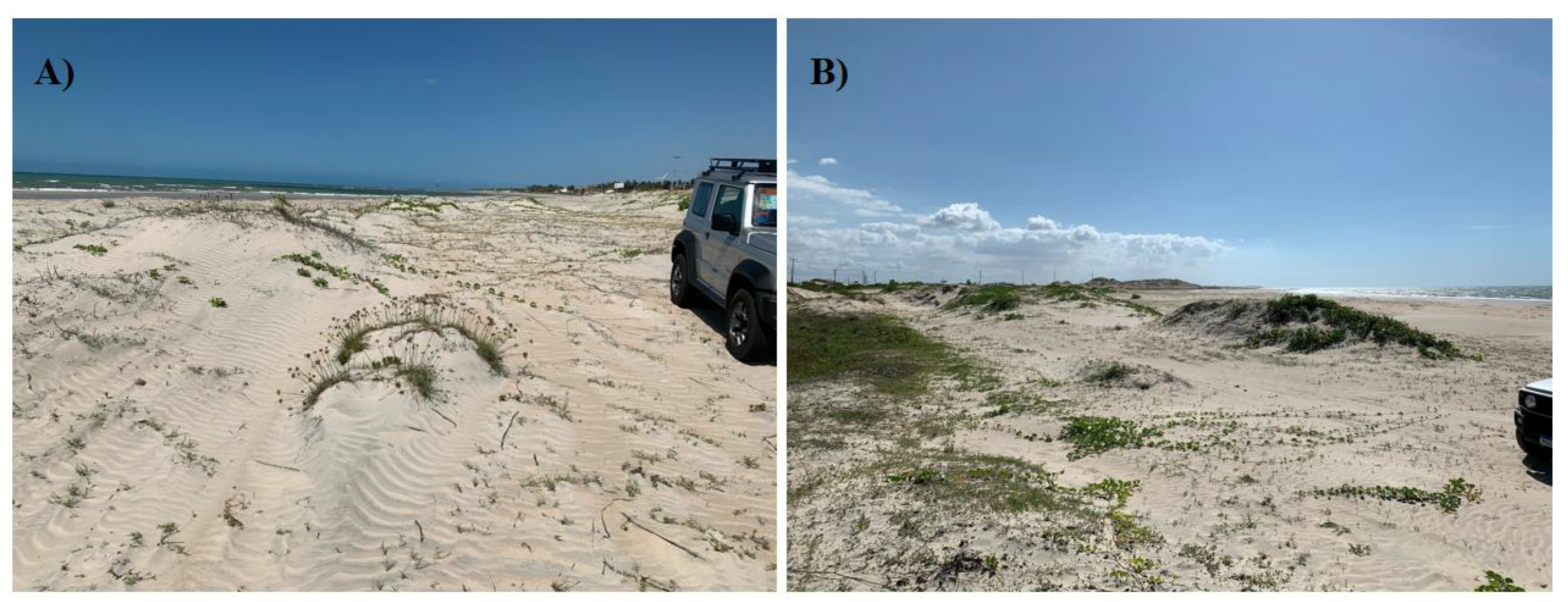
4.1. Geomorphology and Morphodynamics
4.2. Sedimentology
4.3. Sedimentary Structures
5. Discussion
6. Conclusions
Author Contributions
Funding
Data Availability Statement
Acknowledgments
Conflicts of Interest
References
- Hesp, P.A. A review of biological and geomorphological processes involved in the initiation and development of incipient foredunes. Proc. R. Soc. Edinburgh. Sect. B. Biol. Sci. 1989, 96, 181–201. [Google Scholar] [CrossRef]
- Hesp, P.A. Foredunes and blowouts: Initiation, geomorphology and dynamics. Geomorphology 2002, 48, 245–268. [Google Scholar] [CrossRef]
- SEMA. Atualização do projeto de Zoneamento Ecológico-econômico da Zona Costeira do Estado do Ceará. Secretaria Estadual do Meioambinete do Ceará. 2022, 264p. Available online: https://www.sema.ce.gov.br/gerenciamento-costeiro/zoneamento-ecologico-economico-da-zona-costeira-zeec/documentos-previos-para-consulta-publica-do-zeec/ (accessed on 11 August 2022).
- Silva, L.C.; Araújo, R.C.P.; Maia, L.P.; Cavalcante, M.D. Zoneamento ecológico- econômico da zona costeira do estado do Ceará. In Zoneamento Ecológico- Econômico do Ceará—Zona Costeira Maria Dias Cavalcante; Maia, L.P., de Castro MIranda, P.d.T., Eds.; SEMACE: Fortaleza, Brazil, 2006; Volume 1, pp. 93–101. [Google Scholar]
- Hesp, P.A.; Dillemburg, S.R.; Barbosa, E.G.; Tomazelli, L.J.; Ayup-Zouain, R.N.; Esteves, L.S.; Gruber, N.L.S.; Toldo, E.E., Jr.; Tabajara, L.L.C.; Clerot, L.C.P. Beach ridges, foredunes or transgressive dunefields? Definitions and an examination of the Torres to Tramandaí barrier system, Southern Brazil. An. Acad. Bras. Ciênc. 2005, 77, 495–508. [Google Scholar] [CrossRef]
- Hesp, P.A. The Beach Backshore and Beyond. In Handbook of Beach and Shoreface Morphodynamics; Short, A.D., Ed.; John Wiley and Sons: Chichester, UK, 1999; pp. 145–170. [Google Scholar]
- Hesp, P.A.; Smyth, T.A.G. Anchored Dunes. In Aeolian Geomorphology: A New Introduction, 1st ed.; Livingstone, I., Warren, A., Eds.; Wiley-Blackwell: Hoboken, NJ, USA, 2019; pp. 157–178. [Google Scholar]
- Cooper, W.S. Coastal sand dunes of Oregon and Washington. In GSA Memoirs; Geological Society of America: Boulder, CO, USA, 1958; Volume 72, pp. 1–162. [Google Scholar]
- Olson, J.S.; van der Maarel, E. Coastal dunes in Europe: A global view. In Perspectives in Coastal Dune Management; Van der Meulen, F., Jungerius, P.D., Visser, J., Eds.; SPB Academic Publishing: The Hague, The Netherlands, 1989; pp. 1–32. [Google Scholar]
- Godfrey, P.J. Climate, plant response, and development of dunes on barrier beaches along the US east coast. Int. J. Biometeorol. 1977, 21, 203–215. [Google Scholar] [CrossRef]
- Goldsmith, V. Coastal sand dunes as geomorphological systems. Proc. R. Soc. Edinb. 1989, 96B, 3–15. [Google Scholar] [CrossRef]
- Hemming, M.A.; Nieuwenhuize, J. Seagrass wrack-induced dune formation on a tropical coast (Banc d’Arguin, Mauritania). Estuar. Coast. Shelf Sci. 1990, 31, 499–502. [Google Scholar] [CrossRef]
- Arens, S.M. Patterns of sand transport on vegetated foredunes. Geomorphology 1996, 17, 339–350. [Google Scholar] [CrossRef]
- Eamer, J.B.R.; Walker, I.J. Quantifying sand storage capacity of large woody debris on beaches using LiDAR. Geomorphology 2010, 118, 33–47. [Google Scholar] [CrossRef]
- Luna, M.C.M.; Parteli, E.J.R.; Duran, O.; Herrmann, H. Model for the genesis of coastal dune fields with vegetation. Geomorphology 2011, 129, 215–224. [Google Scholar] [CrossRef]
- Bird, E.F.C. The Formation of Sand Beach-ridges. Aust. J. Sci. 1960, 22, 349–350. [Google Scholar]
- Goldsmith, V. Internal geometry and origin of vegetated coastal sand dunes. J. Sedim. Pet. 1973, 43, 1128–1143. [Google Scholar]
- Hesp, P.A. Foredune formation in Southeast Australia. In Coastal Geomorphology in Australia; Thom, B.G., Ed.; Academic Press: Cambridge, MA, USA, 1984; pp. 69–97. [Google Scholar]
- Hesp, P.A. Morphology, dynamics and internal stratification of some established foredunes in southeast Australia. Sediment. Geol. 1988, 55, 17–41. [Google Scholar] [CrossRef]
- Byrne, M.L.; McCann, S.B. Strati®cation and sedimentation in complex vegetated coastal dunes, Sable Island, Nova Scotia. Sedim. Geol. 1990, 66, 165–179. [Google Scholar] [CrossRef]
- Hesp, P.A.; Smyth, T.A.G.; Nielsen, P.; Walker, I.J.; Bauer, B.O.; Davidson-Arnott, R.G. Flow deflection over a foredune. Geomorphology 2015, 230, 64–74. [Google Scholar] [CrossRef]
- Arens, S.M.; Baas, A.C.W.; van Boxel, J.H.; Kalkman, C. Influence of reed stem density on foredune development. Earth Surf. Process. Landf. 2001, 26, 176. [Google Scholar] [CrossRef]
- Davidson-Arnott, R.G.D.; Law, M.N. Seasonal patterns and controls on sediment supply to coastal foredunes, Long Point, Lake Erie. In Coastal Dunes: Form and Process; Nordstrom, K.F., Psuty, N.P., Carter, R.W.G., Eds.; Wiley: Hoboken, NJ, USA, 1990. [Google Scholar]
- Kuriyama, Y.; Mochizuki, N.; Tsuyoshi, N. Inuence of vegetation on aeolian sand transport rate from a backshore to a foredune at Hasaki, Japan. Sedimentology 2005, 52, 1123–1132. [Google Scholar] [CrossRef]
- McLean, R.; Shen, J.S. From foreshore to foredune: Foredune development over the last 30 years at Moruya Beach, New South Wales. J. Coast. Res. 2006, 22, 28–36. [Google Scholar] [CrossRef]
- Zarnetske, P.L.; Ruggiero, P.; Seabloom, E.W.; Hacker, S.D. Coastal foredune evolution: The relative influence of vegetation and sand supply in the US Pacific Northwest. J. R. Soc. Interface 2015, 12, 20150017. [Google Scholar] [CrossRef]
- De Vries, S.; Southgate, H.; Kanning, W.; Ranasinghe, R. Dune behavior and aeolian transport on decadal timescales. Coast. Eng. 2012, 67, 41–53. [Google Scholar] [CrossRef]
- Durán, O.; Moore, L.J. Vegetation controls on the maximum size of coastal dunes. Proc. Natl. Acad. Sci. USA 2013, 110, 17217–17222. [Google Scholar] [CrossRef]
- Keijsers, J.G.S.; De Groot, A.V.; Riksen, M.J.P.M. Vegetation and sedimentation on coastal foredunes. Geomorphology 2015, 228, 723–734. [Google Scholar] [CrossRef]
- Houston, J.A.; Jones, C.R. The Sefton Coast management scheme: Project and process. Coast. Manag. 1987, 15, 267–297. [Google Scholar] [CrossRef]
- Carlson, J.; Reckendorf, F.; Temyik, W. Stabilizing Coastal Sand Dunes in the Pacific Northwest. In USDA Soil Conservation Service SCS Agriculture Handbook; United States Department of Agriculture: Washington, DC, USA, 1991; Volume 687, 53p. [Google Scholar]
- Arens, S.M.; Jungerius, P.D.; van der Meulen, F. Coastal dunes. In Chapter 9: Habitat Conservation: Managing the Physical Environment; Warren, A., French, J.R., Eds.; Wiley: New York, NY, USA, 2001. [Google Scholar]
- Edmondson, S.E.; Velmans, C. Public perception of nature management on a sand dune system. In Coastal Dune Management: Shared Experience of European Conservation Practice; Houston, J.A., Edmondson, S.E., Rooney, P.J., Eds.; Liverpool University Press: Liverpool, UK, 2001; pp. 206–218. [Google Scholar]
- Zwart, F. Dune management and communication with local inhabitants. In Coastal Dune Management: Shared Experience of European Conservation Practice; Houston, J.A., Edmondson, S.E., Rooney, P.J., Eds.; Liverpool University Press: Liverpool, UK, 2001; pp. 219–222. [Google Scholar]
- Allan, J.C.; Komar, P.D.; Hart, R. A dynamic revetment and reinforced dune as “natural” forms of shore protection in an Oregon state park. In Proceedings of the Coastal Structures 2003 Conference, Portland, OR, USA, 26–30 August 2003; pp. 1048–1060. [Google Scholar]
- Allan, J.C.; Komar, P.D. Environmentally compatible cobble berm and artificial dune for shore protection. Shore Beach 2004, 72, 9–18. [Google Scholar]
- Komar, P.D.; Allan, J.C. “Design with Nature” Strategies for Shore Protection—The Construction of a Cobble Berm and Artificial Dune in an Oregon State Park: U.S. Geological Survey Scientific Investigations Report 2010, 2010–5254. Available online: https://pubs.usgs.gov/sir/2010/5254/pdf/sir20105254_chap12.pdf (accessed on 11 August 2022).
- Nordstrom, K.F.; Jackson, N.L. Foredune Restoration in Urban Settings. In Chapter 2: Restoration of Coastal Dunes; Springer Series 17 on Environmental Management; Martínez, L.M., Gallego-Fernández, J.B., Hesp, P.A., Eds.; Springer: Berlin/Heidelberg, Germany, 2013. [Google Scholar] [CrossRef]
- Portz, L.; Manzolli, R.P.; Hermanns, L.; Carrio, J.A. Evaluation of the efficiency of dune reconstruction techniques in Xangri-la (Rio Grande do Sul, Brazil). Ocean. Coast. Manag. 2015, 104, 78–89. [Google Scholar] [CrossRef]
- Elko, N.; Brodie, K.; Stockdon, H.; Nordstrom, K.; Houser, C.; McKenna, K.; Moore, L.; Rosati, J.; Ruggiero, P.; Thuman, R.; et al. Dune management challenges on developed coasts. Shore Beach 2016, 84, 15. [Google Scholar]
- Arens, S.M. Aeolian Processes in the Dutch Foredunes. Ph.D. Thesis, University of Amsterdam, Amsterdam, The Netherlands, 1994; 150p. [Google Scholar]
- Arens, S.M.; van der Lee, G.E.M. Saltation sand traps for the measurement of aeolian transport into the foredunes. Soil Technol. 1995, 8, 61–74. [Google Scholar] [CrossRef]
- Arens, S.M. Rates of aeolian sand transport on a beach in a temperate humid climate. Geomorphology 1996, 17, 3–18. [Google Scholar] [CrossRef]
- Arens, S.M. Transport rates and volume changes in a coastal foredune on a Dutch Wadden island. J. Coast. Conserv. 1997, 3, 49–56. [Google Scholar] [CrossRef]
- Matias, A.; Ferreira, O.; Mendes, I.; Dias, J.A.; Vila-Concejo, A. Artificial Construction of Dunes in the South of Portugal. J. Coast. Res. 2005, 21, 472–481. [Google Scholar] [CrossRef]
- Eichmanns, C.; Schüttrumpf, H. Influence of Sand Trapping Fences on Dune Toe Growth and Its Relation with Potential Aeolian Sediment Transport. J. Mar. Sci. Eng. 2021, 9, 850. [Google Scholar] [CrossRef]
- Eichmanns, C.; Lechthaler, S.; Zander, W.; Pérez, M.V.; Blum, H.; Thorenz, F.; Schüttrumpf, H. Sand Trapping Fences as a Nature-Based Solution for Coastal Protection: An International Review with a Focus on Installations in Germany. Environments 2021, 8, 135. [Google Scholar] [CrossRef]
- Tsoar, H.; Levin, N.; Porat, N.; Maia, L.P.; Herrmann, H.J.; Tatumi, S.H.; Claudino-Sales, V. The effect of climate change on the mobility and stability of coastal sand dunes in Ceará State (NE Brazil). Quat. Res. 2009, 71, 217–226. [Google Scholar] [CrossRef]
- Ferreira, A.G.; da Silva Mello, N.G. Principais Sistemas atmosféricos atuantes sobre a região Nordeste do Brasil e a influência dos oceanos Pacíficos e Atlântico no clima da região. Rev. Bras. Climatol. 2015, 1, 15–28. [Google Scholar] [CrossRef]
- Claudino-Sales, V. Lagoa do Papipu: Natureza e Ambiente na Cidade de Fortaleza, Ceara. Master’s Thesis, Universidade de Sao Paulo, Sao Paulo, Brazil, 1993. [Google Scholar]
- Carvalho, A.M. Dinâmica Costeira entre Cumbuco e Matões-Costa NW do Estado do Ceará. Ênfase nos Processos Eólicos. Ph.D. Thesis, Universidade Federal da Bahia, Salvador, Brazil, 2003; 188p. [Google Scholar]
- Pinheiro, L.; de Morais, J.O.; Maia, L.P. The Beaches of Ceará. In Brazilian Beach Systems. Coastal Research Library; Short, A., Klein, A., Eds.; Springer: Cham, Switzerland, 2016; Volume 17. [Google Scholar] [CrossRef]
- Silvester, R. Growth of crenulate shaped bays to equilibrium. J. Water Harb. Div. Am. Soc. Civ. Eng. 1970, 76, 275–287. [Google Scholar] [CrossRef]
- Hsü, J.R.-C.; Evans, C. Parabolic bay shapes and applications. In Proceedings of Institution of Civil Engineers—Part 2; Thomas Telford: London, UK, 1989. [Google Scholar]
- Hsü, J.R.C.; Uda, T.; Silvester, R. Beach downcoast of harbours in bays. Coast. Eng. 1993, 19, 163–181. [Google Scholar] [CrossRef]
- Carvalho, A.M.; Ellis, J.T.; Lamothe, M.; Maia, L.M. Using Wind Direction and Shoreline Morphology to Model Sand Dune Mobilization. J. Coast. Res. 2016, 32, 1005–1015. [Google Scholar] [CrossRef]
- Miot da Silva, G.; Hesp, P.A. Coastline orientation, aeolian sediment transport and foredune and dunefield dynamics of Moçambique Beach, Southern Brazil. Geomorphology 2010, 120, 258–278. [Google Scholar] [CrossRef]
- Annan, A.P. Ground Penetration Radar; Internal Report; Workshop Notes, Sensors and Software, Inc.: Mississauga, ON, Canada, 1992; 130p. [Google Scholar]
- Daniels, J.J. Fundamentals of ground penetrating radar. In Proceedings of the Symposium on the Application of Geophysics to Engineering and Environmental Problems, Golden, CO, USA, 13–16 March 1989; pp. 62–142. [Google Scholar]
- Annan, A.P. Pratical processing of GPR data. In Proceedings of the Second Government Workshop on Ground Penetrating Radar, Columbus, OH, USA, 26–28 October 1993; Volume 2. 26p. [Google Scholar]
- Suguio, K. Introdução à Sedimentologia; EDUSP: São Paulo, SP, USA, 1973; 317p. [Google Scholar]
- Wentworth, C.K. A scale of grade and class terms for clastic sediments. J. Geol. 1922, 30, 377–392. [Google Scholar] [CrossRef]
- De Camargo, M.G. Sysgran: Um sistema de código aberto para análises granulométricas do sedimento. Rev. Bras. Geociênc. 2006, 36, 371–378. [Google Scholar] [CrossRef]
- Folk, R.L.; Ward, W.C. Brazos River bar: A study in the significance of grain size parameters. J. Sediment. Petrol. 1957, 27, 3–26. [Google Scholar] [CrossRef]
- Anders, F.; Leatherman, S. Disturbance of beach sediment by off-road vehicles. Environ. Geol. 1987, 9, 183–189. [Google Scholar] [CrossRef]
- Anders, F.J.; Leatherman, S.P. Effects of off-road vehicles on coastal foredunes at Fire Island, New York, USA. Environ. Manag. 1987, 11, 45–52. [Google Scholar] [CrossRef]
- Bruun, P. Beach scraping—Is it damaging to beach stability? Coast. Eng. 1983, 7, 167–173. [Google Scholar] [CrossRef]
- Smyth, T.A.G.; Hesp, P.A. Aeolian dynamics of beach scraped ridge and dyke structures. Coast. Eng. 2015, 99, 38–45. [Google Scholar] [CrossRef]
- Cooper, W.S. Coastal dunes of California. In GSA Memoirs; Geological Society of America: Boulder, CO, USA, 1967; Volume 104, pp. 1–124. [Google Scholar]
- Hesp, P.A. Dune Coasts. In Treatise on Estuarine and Coastal Science; Wolanski, E., McLusky, D.S., Eds.; Academic Press: Waltham, MA, USA, 2011; Volume 3, pp. 193–221. [Google Scholar]
- Melton, F.A. A tentative classification of sand dunes its application to dune history in the southern High Plains. Geology 1940, 48, 113–174. [Google Scholar] [CrossRef]
- Marston, R.A. Maneuver-caused wind erosion impacts, south central New Mexico. In Aeolian Geomorphology; Nickling, W.G., Ed.; Allen and Unwin: Boston, MA, USA, 1986; pp. 273–290. [Google Scholar]
- Khalaf, F.I.; Misak, R.; Al-Dousari, A. Sedimentological and morphological characteristics of some nabkha deposits in the northern coastal plain of Kuwait, Arabia. J. Arid. Environ. 1995, 29, 267–292. [Google Scholar] [CrossRef]
- Carter, R.W.G.; Hesp, P.A.; Nordstrom, K.F. Erosional landforms in coastal dunes. In Coastal Dunes: Form and Process; Nordstrom, K.F., Psuty, N.P., Carter, R.W.G., Eds.; Wiley: Chichester, UK, 1990; pp. 217–249. [Google Scholar]
- Jackson, D.W.T.; Beyers, M.; Delgado-Fernandez, I.; Baas, A.C.W.; Cooper, A.J.; Lynch, K. Airflow reversal and alternating corkscrew vortices in foredune wake zones during perpendicular and oblique offshore winds. Geomorphology 2013, 187, 86–93. [Google Scholar] [CrossRef]
- Bauer, B.O.; Davidson-Arnott, R.G.D.; Walker, I.J.; Hesp, P.A.; Ollerhead, J. Wind direction and complex sediment transport response across a beach-dune system. Earth Surf. Process. Landf. 2012, 37, 1661–1677. [Google Scholar] [CrossRef]
- Bauer, B.O.; Walker, I.J.; Baas, A.C.W.; Jackson, D.W.T.; Neuman, C.M.; Wiggs, G.F.S.; Hesp, P.A. Critical reflections on the coherent flow structures paradigm in aeolian geomorphology. In Coherent Flow Structures at Earth’s Surface; Venditti, J.G., Best, J.L., Church, M., Hardy, R.J., Eds.; John Wiley: Chichester, UK, 2013; pp. 111–134. [Google Scholar] [CrossRef]
- Schwarz, C.; van Starrenburg, C.; Donker, J.; Ruessink, G. Wind and sand transport across a vegetated foredune slope. J. Geophys. Res. Earth Surf. 2020, 125, e2020JF005732. [Google Scholar] [CrossRef]
- Bauer, B.O.; Davidson-Arnott, R.G.D. A general framework for modeling sediment supply to coastal dunes including wind angle, beach geometry, and fetch effects. Geomorphology 2003, 49, 89–108. [Google Scholar] [CrossRef]
- Carvalho, A.M.; Lima, S.B., Jr.; Maia, L.P.; Claudino-Sales, V.; Gastão, F.G.C.; Eduardo, L.M.; Pinheiro, L.S.; Silva, M.V.C. Understanding polydirectional aeolian cross-strata architecture in a coastal unidirectional wind regime. J. Coast. Res. 2021, 37, 364–379, Coconut Creek (Florida). [Google Scholar] [CrossRef]
- Cooper, A.; Jackson, D. Dune gardening? A critical view of the contemporary coastal dune management paradigm. Area 2021, 53, 345–352. [Google Scholar] [CrossRef]
- Van der Wal, D. Aeolian Transport of Nourishment Sand in Beach-Dune Environments; Universiteit van Amsterdam: Amsterdam, The Netherlands, 1999. [Google Scholar]
- Saunders, K.E.; Davidson-Arnott, R.G.D. Coastal dune response to natural disturbances. In Proceedings of the Symposium on Coastal Sand Dunes 1990, Guelph, ON, Canada, 12–14 September 1990; National Research Council: Ottawa, ON, Canada, 1990; pp. 321–345. [Google Scholar]
- Zarnetske, P.L.; Hacker, S.D.; Seabloom, E.W.; Ruggiero, P.; Killian, J.R.; Maddux, T.B.; Cox, D. Biophysical feedback mediates eects of invasive grasses on coastal dune shape. Ecology 2012, 93, 1439–1450. [Google Scholar] [CrossRef] [PubMed]
- Nordstrom, K.F. Beaches and dunes of human-altered coasts. Prog. Phys. Geogr. 1994, 18, 497–516. [Google Scholar] [CrossRef]
- Dugan, J.E.; Hubbard, D.M.; Rodil, I.F.; Revell, D.L.; Schroeter, S. Ecological effects of coastal armoring on sandy beaches. Mar. Ecol. 2008, 29 (Suppl. 1), 160–170. [Google Scholar] [CrossRef]
- Bressolier, C.; Thomas, Y.-F. Studies on wind and plant interactions on French Atlantic coastal dunes. J. Sediment. Petrol. 1977, 47, 331–338. [Google Scholar]
- Hesp, P.A. The formation of shadow dunes. J. Sediment. Petrol. 1981, 51, 101–112. [Google Scholar]
- Nickling, W.G.; Davidson-Arnott, R.G.D. Aeolian sediment transport on beaches and coastal dunes. In Proceedings of the Symposium on Coastal Sand Dunes 1990, Guelph, ON, Canada, 12–14 September 1990; National Research Council: Ottawa, ON, Canada, 1990; pp. 1–35. [Google Scholar]
- Pye, K.; Tsoar, H. Aeolian Sand and Sand Dunes; Unwin Hyman: London, UK, 1990; p. 396. [Google Scholar]
- Ahlbrandt, T.S.; Swinehart, J.B.; Maroney, D.G. The dynamic Holocene dune fields of the Great Plains and Rocky Mountain basins, U.S.A. In Eolian Sediments; Brookfield, M.E., Ahlbrandt, T.S., Eds.; Elsevier: Amsterdam, The Netherlands, 1983; Volume 38, pp. 379–406. [Google Scholar]
- Tinley, K.L. Coastal dunes of South Africa, South African National Scientific Programmes Report; Council for Scientific and Industrial Research: Pretoria, South Africa, 1985; Volume 109, 300p. [Google Scholar]
- Holm, D.A. Desert geomorphology in the Arabian Peninsula. Science 1960, 132, 1369–1379. [Google Scholar] [CrossRef]
- Warren, A. Dunes in the Tenere desert. Geogr. J. 1971, 137, 458–461. [Google Scholar] [CrossRef]
- Wilson, I.G. Ergs. Sediment. Geol. 1973, 10, 77–106. [Google Scholar] [CrossRef]
- Nielson, J.; Kocurek, G. Climbing zibars of the Algodones. Sed. Geol. 1986, 48, 1–15. [Google Scholar] [CrossRef]
- Kocurek, G.; Townsley, M.; Yeh, E.; Havholm, K.; Sweet, M.L. Dune and dune-field development on Padre Island, Texas, with implications for interdune deposition and water-table-controlled accumulation. J. Sediment. Res. 1992, 62, 622–635. [Google Scholar]
- Lancaster, N. Dunes on the Skeleton Coast, Namibia (South West Africa): Geomorphology and grain size relationships. Earth Surf. Proc. Land 1982, 7, 575–587. [Google Scholar] [CrossRef]
- Lancaster, N. Field studies of sand patch initiation processes on the northern margin of the Namib sand sea. Earth Surf. Proc. Land 1996, 21, 947–954. [Google Scholar] [CrossRef]
- Kroy, K.; Sauermann, G.; Herrmann, H.J. Minimal model for sand dunes. Phys. Rev. Lett. 2002, 88, 054301. [Google Scholar] [CrossRef] [PubMed]
- Momiji, H.; Nishimori, H.; Bishop, S.R. On the shape and migration speed of a proto-dune. Earth Surf. Proc. Land 2002, 27, 1335–1338. [Google Scholar] [CrossRef]
- Elbelrhiti, H.; Claudin, P.; Andreotti, B. Field evidence for surface-wave-induced instability of sand dunes. Nature 2005, 437, 720. [Google Scholar] [CrossRef]
- Bristow, C.S.; Jol, H.M.; Augustinus, P.; Wallis, I. Slipfaceless ‘whaleback’ dunes in a polar desert, Victoria Valley, Antarctica: Insights from ground penetrating radar. Geomorphology 2010, 114, 361–372. [Google Scholar] [CrossRef]
- Andreotti, B.; Claudin, P.; Pouliquen, O. Measurements of the aeolian sand transport saturation length. Geomorphology 2010, 123, 343–348. [Google Scholar] [CrossRef]
- Elbelrhiti, H. Initiation and early development of barchan dunes: A case study of the Moroccan Atlantic Sahara desert. Geomorphology 2012, 138, 181–188. [Google Scholar] [CrossRef]
- Nield, J.M.; Wiggs, G.F.; Squirrell, R.S. Aeolian sand strip mobility and protodune development on a drying beach: Examining surface moisture and surface roughness patterns measured by terrestrial laser scanning. Earth Surf. Proc. Land 2011, 36, 513–522. [Google Scholar] [CrossRef]
- Ewing, R.C.; McDonald, G.D.; Hayes, A.G. Multi-spatial analysis of aeolian dune field patterns. Geomorphology 2015, 240, 44–53. [Google Scholar] [CrossRef]
- Kocurek, G.; Ewing, R.C. Trickle-Down and trickle-up boundary conditions in eolian dune-field pattern formation. In Autogenic Dynamics and Self-Organization in Sedimentary Systems; Budd, D.A., Hajek, E.A., Purkis, S.J., Eds.; SEPM (Society for Sedimentary Geology): Tulsa, OK, USA, 2016; pp. 5–17. [Google Scholar] [CrossRef]
- Phillips, J.D.; Ewing, R.C.; Bowlinga, R.R.; Weymerb, B.A.; Barrineauc, P.; Nittrouerd, J.A.; Everetta, M.E. Low-angle eolian deposits formed by protodune migration, and insights into slipface development at White Sands Dune Field, New Mexico. Aeolian Res. 2019, 36, 9–26. [Google Scholar] [CrossRef]
- Goldsmith, V. Coastal dunes. In Coastal Sedimentary Environments; Davis, R.A., Ed.; Springer: New York, NY, USA, 1978; pp. 171–235. [Google Scholar]
- Nordstrom, K.F.; Arens, S.M. The role of human actions in evolution and management of foredunes in The Netherlands and New Jersey, USA. J. Coast. Conserv. 1998, 4, 169–180. [Google Scholar] [CrossRef]


| Year | Crest Area (CA) | Vegetal Cover (VC) | %VC |
|---|---|---|---|
| 2004 | 21,862.05 m² | 7632.34 m² | 34.91% |
| 2012 | 13,496.89 m² | 8568.88 m² | 63.49% |
| 2018 | 14,977.08 m² | 8204.49 m² | 55.15% |
| Sample | Mdɸ | Skiɸ | Kgɸ | Siɸ | Folk & Ward Classification |
|---|---|---|---|---|---|
| F1 | 1.667 | −0.040 | 1.023 | 0.489 | Well-sorted medium sand |
| F2 | 1.747 | −0.025 | 0.846 | 0.492 | Well-sorted medium sand |
| T1 | 1.701 | 0.008 | 0.947 | 0.455 | Well-sorted medium sand |
| T2 | 1.788 | −0.032 | 0.890 | 0.462 | Well-sorted medium sand |
| T3 | 1.830 | −0.083 | 0.856 | 0.476 | Well-sorted medium sand |
| T4 | 1.748 | −0.028 | 0.907 | 0.702 | Moderately sorted medium sand |
| T5 | 1.851 | −0.051 | 0.882 | 0.439 | Well-sorted medium sand |
| T6 | 1.690 | 0.016 | 0.971 | 0.427 | Well-sorted medium sand |
| T7 | 2.133 | −0.217 | 0.996 | 0.373 | Well-sorted fine sand |
Publisher’s Note: MDPI stays neutral with regard to jurisdictional claims in published maps and institutional affiliations. |
© 2022 by the authors. Licensee MDPI, Basel, Switzerland. This article is an open access article distributed under the terms and conditions of the Creative Commons Attribution (CC BY) license (https://creativecommons.org/licenses/by/4.0/).
Share and Cite
de Carvalho, A.M.; Claudino-Sales, V.; Lima Junior, S.B.; Eduardo, L.M.; da Costa Gastão, F.G.; de Souza Pinheiro, L. Should Anthropic Ridges Framed as Foredunes Be Considered Real Dunes? Geosciences 2022, 12, 364. https://doi.org/10.3390/geosciences12100364
de Carvalho AM, Claudino-Sales V, Lima Junior SB, Eduardo LM, da Costa Gastão FG, de Souza Pinheiro L. Should Anthropic Ridges Framed as Foredunes Be Considered Real Dunes? Geosciences. 2022; 12(10):364. https://doi.org/10.3390/geosciences12100364
Chicago/Turabian Stylede Carvalho, Alexandre Medeiros, Vanda Claudino-Sales, Sergio Bezerra Lima Junior, Leticia Mesquita Eduardo, Francisco Gleidson da Costa Gastão, and Lidriana de Souza Pinheiro. 2022. "Should Anthropic Ridges Framed as Foredunes Be Considered Real Dunes?" Geosciences 12, no. 10: 364. https://doi.org/10.3390/geosciences12100364
APA Stylede Carvalho, A. M., Claudino-Sales, V., Lima Junior, S. B., Eduardo, L. M., da Costa Gastão, F. G., & de Souza Pinheiro, L. (2022). Should Anthropic Ridges Framed as Foredunes Be Considered Real Dunes? Geosciences, 12(10), 364. https://doi.org/10.3390/geosciences12100364