Review

Combined Zonation of the African-Levantine-Caucasian Areal of Ancient Hominin: Review and Integrated Analysis of Paleogeographical, Stratigraphic and Geophysical-Geodynamical Data

1
Porter School of the Environment and Earth Sciences, Faculty of Exact Sciences, Tel Aviv University, Ramat Aviv, Tel Aviv 6997801, Israel
2
Department of Geophysics, Geological Faculty, Azerbaijan State Oil and Industry University, 20 Azadlig Ave., Baku AZ1010, Azerbaijan
3
Steinhardt Museum of Natural History & National Research Center, Faculty of Life Sciences, Tel Aviv University, Ramat Aviv, Tel Aviv 6997801, Israel
*
Author to whom correspondence should be addressed.
Geosciences 2022, 12(1), 21; https://doi.org/10.3390/geosciences12010021
Submission received: 29 November 2021 / Revised: 23 December 2021 / Accepted: 2 January 2022 / Published: 5 January 2022

Abstract

:
The origin of the man on Earth is directly associated with the determination of directions of the flow distribution of the ancient man dispersal to adjacent territories. In such studies, mainly landscape and climatological changes are traditionally considered. We suggest that along with the above factors, regional tectonic-geodynamic factors played a dominant role in the character of dispersal. The considered African-Levantine-Caucasian region is one of the most geologically complex regions of the world, where collisional and spreading processes of geodynamics converge. For the first time, we determined an essential influence of the Akchagylian hydrospheric maximum (about 200 m above the mean sea level) limiting the early dispersal of hominins from Africa to Eurasia. We propose that the Levantine Corridor emerged after the end of the Akchagylian transgression and landscape forming in the Eastern Mediterranean. This corridor location was formed by the movements between the Dead Sea Transform and the boundary of the carbonate platform of the Mesozoic Terrane Belt. Further landscape evolution was largely determined by the geodynamic behavior of the deep mantle rotating structure occurring below the central part of the region under study. All the mentioned events around and in the Levantine Corridor have been studied in detail on the basis of the combined geodynamic, paleogeographic, and paleomagnetic analyses performed in northern Israel (Carmel Uplift and Galilee Plateau). Careful studies of the Evron Quarry geological section indicate that it is unique for the dating of marine and continental archaeological sequences and sheds light on the early dispersal of hominins along the Levantine Corridor.

1. Introduction

The problem of origin, features of evolution, changes in the landscape and climatic conditions of habitation and dispersal of ancient hominin ultimately forced to formulate a number of promising methodological and theoretical studies [1,2,3,4]. Since this most important research program is associated with the Late Cenozoic history of the Earth (and not only with it, but also with its most active tectonic region), we consider it necessary to reveal the leading geological and geophysical factors of the appearance and development of ancient humans in the transition zone from Africa to Eurasia [5,6].
In this regard, the Eastern Mediterranean is the central region through which, for many hundreds of thousands of years (and in general—according to the radiometric and paleomagnetic data [7] about 2.0 Ma), hominin moved from the primary East African range to Eurasia regions (Figure 1).
The narrow Levantine Corridor was an important link in this route of movement [8]. It passed near the coastline of the Neotethys-Mediterranean basin in the epoch of early dispersal of hominins [9], which was changing its shape due to tectonic-eustatic and glacioeustatic factors of geodynamics [10,11].
If we consider the dispersal path as a whole, then the paradox of the seemingly ruptured biogeographic region of ancient hominin, which includes three disjunct areas: (1) the East African Rift Belt, (2) the carbonate platform of the Mesozoic Terrane Belt, and (3) the East Anatolian-Caucasian zone of the Alpine orogen. This topological paradox is well illustrated by numerous paleo-archaeological, anthropological, paleontological, paleomagnetic, radiometric and landscape-ecosystem research methods [1,3,7,12,13,14,15,16,17,18,19,20,21,22]. However, from the standpoint of regional geology and the evolution of terrestrial processes, it has not been systematically analyzed due to the fact that the data of global geodynamic mapping and zonation of this complex region became the subject of generalization only recently [23,24,25,26,27,28,29].
To solve these problems, a variety of mapping methods were applied: paleogeographic, geomorphological, geophysical, paleomagnetic, structural-tectonic, and planetary-geodynamic. Together with them, both their own data [10,30,31,32] and bibliographic sources in the field of historical planetology, cyclic stratigraphy, paleopedology, and ecological-stratigraphic analysis were widely involved in order to compare marine and continental formations. Along with this, numerous data on geological mapping were attracted [23,24,33,34,35,36,37,38]. The unique sections, where marine and lagoon formations are replaced by continental ones, containing Acheulean artifacts with numerous remains of large mammals have been investigated [13,19,39,40,41].
The constructed maps and diagrams make it possible to shed light on the planetary-genetic reasons for the evolution of early hominins: landscape-geomorphological, paleoclimatic, geodynamic, and deep tectonic-thermal and hydrospheric factors of the development of their habitat. A description and analysis of the comparison of the obtained materials with anthropological data are given below in the relevant sections.

2. Formulation of the Problem

Human origins on the Earth and the ways of his dispersal are, in fact, among the most important problems in the field of natural sciences [1,3,7,15,19,21]. The discoveries of the past decades have allowed for a significant breakthrough in the field of ancient ecosystems, where the way of life of ancient hominins, artifacts of that time, and elements of biotic and abiotic habitats were studied. However, if we will speak about the abiotic factors, only landscape and climatic features were usually considered. The factors of the regional geological-geophysical environment were used only partially (for example, [5]).
It should be noted that the region of the Eastern Mediterranean and the adjacent regions of Eurasia and East Africa is one of the most complex in the world in geological and geophysical terms. Many of the most important features of its structure have been identified only in recent years [23,24,25,26,27,29,42]. Therefore, as the leading items of research, we applied the method of analysis of hydrospheric disturbances, new aspects of plate geodynamics, and detailed integrated methods of geological mapping, paleogeography, and event stratigraphy.
We propose that the emergence of the noosphere [43] was preceded by three main events that determined the emergence and development of Man. The first of them, the inception of the evolution of hominin, was caused by the Messinian crisis [6], a plate tectonic event [44] that caused the drainage of the residual Tethys Ocean and vast shelf spaces, and the development of climate aridization and a sharp change in ecosystems in the equatorial segment of the Earth in the epoch of 5.8–5.3 Ma ago. The second most important event was the Akchagylian hydrospheric maximum (3.6–1.8 Ma ago), which caused flooding of the shelf of southern Eurasia and, in part, high plateaus, and erosional valleys adjacent to the Mediterranean [11]. The third event is associated with the regression of the end of the Post-Absheronian (Post-Calabrian), and the emergence of vast glaciation on the continental platforms of the northern hemisphere (0.9–0.8 Ma ago).
Let us go back to the second event. Climate humidification in the equatorial segment led to the intensification of glaciation at the poles and in the highlands [45], and an abrupt change of landscapes in the primary habitat of hominin with the replacement of tropical forests by grassy savanna [1,2,46,47,48,49], and biotic communities [17,49]. Under these conditions, the nature of the evolution of primates changed towards the development of the stone industry [2], socialization, and mastery of fire [14,16,50,51].
The maximum Akchagylian transgression of 2.6–2.1 Ma ago (up to +200 m above the modern mean sea level) [11] closed the dispersal route to the north, where there were vast bays, mountain ranges, and arid volcanic plateaus. Only in the epoch of the Late Akchagylian regression 2.0–1.8 Ma ago and in the process of activation of the deep mantle structure [29] with the formation of fault valleys and strike-slip basins, did the descending structure of the Levantine Corridor appear. Its favorable ecosystems served as multiple stopovers on the way of Man′s movement to the east of the Southwest Asia. At the end of the Late Akchagylian regression period (about 1.1–0.8 Ma ago), there was the development by Man [21] of southern Eurasia and northern Africa [3,52].
The subsequent epoch of human dispersal and evolution was qualitatively different [53] both in terms of planetary (meridian skew of the Earth′s figure with the intensification of seismological and glaciotectonic movements), contrasting climate of the epoch of continental glaciations with the sharp fluctuations in the sea levels [54,55]. The factors of changes in the abiotic environment contributed to fundamental changes in the composition of ecosystems [56]. From this point of view, the concept of the Quaternary period (or Anthropocene [57]) is planetologically specific and does not depend on regional factors and the professional arguments of certain research groups or schools. The change of the Neogene equatorial transgression to the polar one with a corresponding change in the shape and speed of the Earth′s rotation in the Anthropocene (844 thousand years ago) is a natural physical and planetary boundary of the stratigraphic scale. Hydrodynamically, this boundary is marked by the Cassian-Türkian regression of the Tethys-Paratethys basin, corresponding to the mark of the sea-level drop to -200 m [6]. The geodynamical meridian skew of the Earth′s figure was expressed in the movements of the Khovaling tectonic phase between the Kulyab and Kyzyl-Suu series of Central Asia [58].

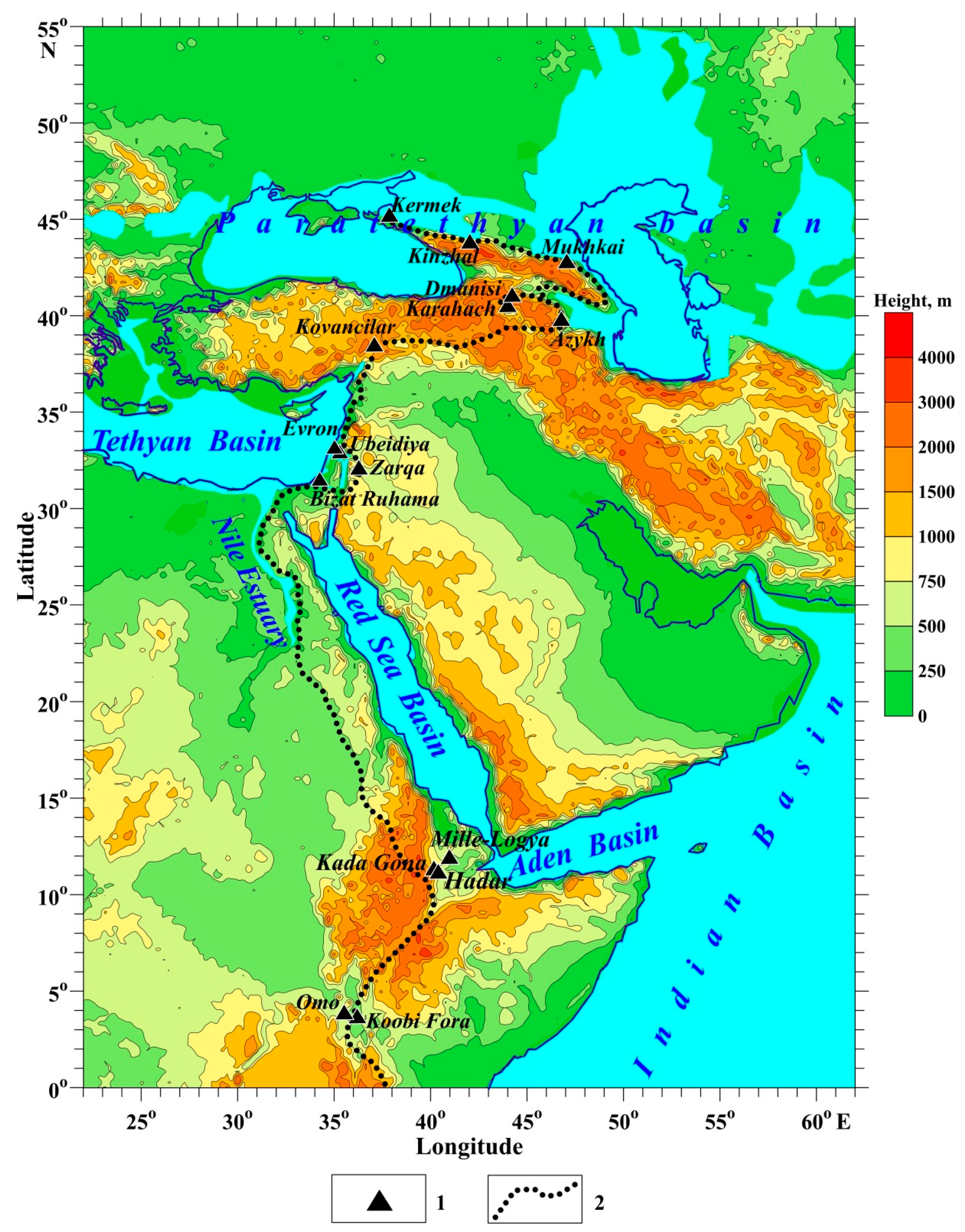
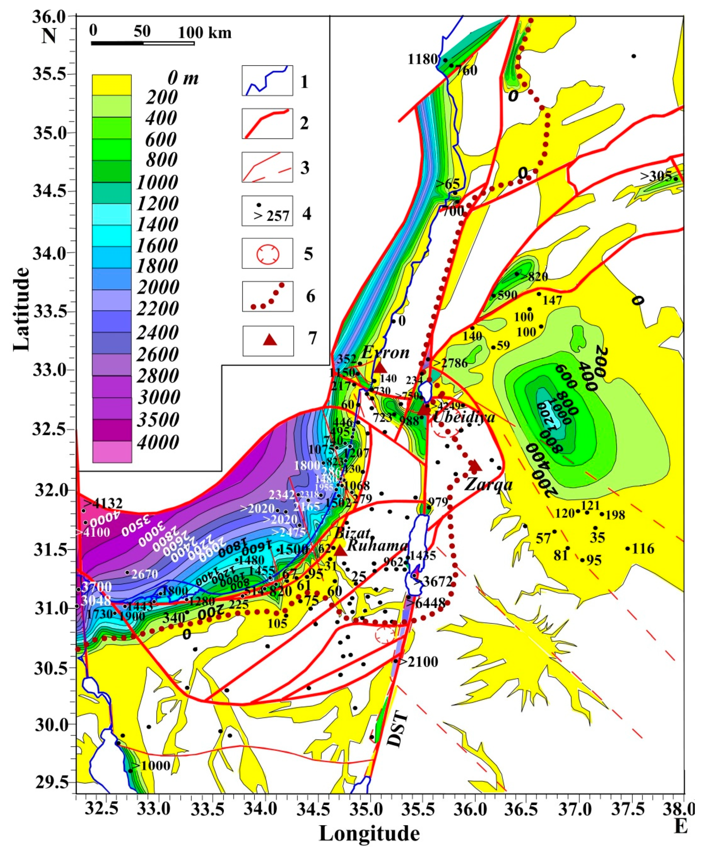
3. Paleogeographic and Geological-Geophysical Aspects

The problem of origin, features of evolution, and settlement of ancient hominin is closely related to the evolution of the habitat, caused by geological and geophysical processes in various shells of the Earth, which form their dynamics and structure. The existence itself of the African-Levantine-Caucasian way of settlement of the ancient Man is associated with the planetary-geophysical uniqueness of the region. Immediately to the east of the way, a step of the Ural-African geoid anomaly is developed, and in the north there is a critical parallel of 35° (Figure 2), which is an area of conjugate deformation of the Earth′s rotation ellipsoid [6,59]. And approximately in the middle of the dispersal path, at the interface between the collisional structures of the Mediterranean and rift-spreading structures of the Red Sea system, there is a projection of the central zone of the deep mantle structure [29,60], which initiates the rotation of the overlying lithospheric formations in a counterclockwise direction.
The East African area of origin of ancient hominin (East African Rift Belt) (Figure 1) is located in the zone of the southern pericline of the deep mantle structure [29], where the Nubian, Arabian, Somalian, and Victorian lithospheric plates are joined in the rift zone (Figure 2). Here, under the conditions of active modern rifting, zones of blocky relief of the volcanic plateaus with the landscapes optimal for the habitation of ancient hominins were formed.
The central Eastern Mediterranean region (carbonate platform of the Mesozoic Terrane Belt of the Levant) is insignificant in the area and is located near the projection of the uplifted zone of the mantle structure (Figure 2). This area was formed at the border of two lithospheric plates, Sinai and Arabian. In this tectonically unstable zone runs the Levantine Corridor (Figure 1), along which the dispersal of ancient hominins from Africa to Eurasia took place for many hundreds of thousands of years. The specific features of this corridor will be discussed below.
The fairly wide and diverse Caucasian range (East Anatolian-Caucasian zone of the Alpine orogen) of ancient hominin [61] is located in the northeastern pericline of the deep mantle structure (Figure 2). An area of active orogenesis is developed here, in which folded, volcanic areas and foothill and intermountain depressions filled with sediments are combined. It is well-known that geodynamic and volcanic events change the landscape and climate and significantly influence to ecosystem evolution. As a result, active dispersal from south to north was carried out, bypassing mountain ranges along the coasts of the Caspian and Euxine basins (Figure 1). The area under consideration is located in the contact zone between the Eurasian, Aegean-Anatolian, and Arabian lithospheric plates. The population of the areas relating to the last two plates was probably insignificant due to the unfavorable geological and landscape conditions, and nature of the ecosystems developed here.
Each of the three tectono-geodynamical zones with the sites of ancient hominin (Table 1) differs in the age of the development of the habitat. The age estimates presented are based on the data of the isotope-radiochronometric and paleomagnetic methods, taking into account the refinement by the methods of stratigraphic and paleogeographic analysis.
The East African range (East African Rift Belt) of the hominin with the oldest finds of artifacts of the Oldowan type of stone industry is 2.6–1.6 Ma old and belongs to the species Homo rudolfensis and H. habilis 2.6–1.9 Ma old and the younger species Homo erectus, which completed the Oldowan industry 1.9–1.6 Ma ago and then began to manufacture Acheulean artifacts and began to master fire and the manufacture of bone and other tools [50].
The Eastern Mediterranean range (carbonate platform of the Mesozoic Terrane Belt of Levant) of the hominin is located about 2000 km north of the previous range, and a dispersal route bypassing the high plateau of the Eastern Desert along the Nile Valley by an extensive estuary and along the valley-cut southeastern coast of the Mediterranean and strike-slip basins of the Dead Sea Transform (DST) significantly increased the hominin dispersal along the as yet undeveloped Levantine Corridor. On the other hand, the absence of ancient sites along the Nile Corridor [3] may be due to the widespread development of the younger Pleistocene alluvium of this extended river.
The oldest artifacts in the area under consideration are located on the Arabian Plate in western Jordan in the Zarqa River Valley north of Amman, in the northern block of the Negev Terrane shifted along the DST line (Figure 3). According to the data of paleomagnetic and radiometric analysis, continental clastic rocks with remains of large mammals and numerous artifacts of the Oldowan type stone industry is 2.0–1.78 Ma and clearly correspond to the epoch of the Late Gelasian and the stage of the Late Akchagylian regression. This is a very well-defined narrow interval on the chronostratigraphic scale, not exceeding 250 thousand years. To the west of the DST, there are very important classical Levantine sites with the Acheulean stone industry and traces of the use of fire [15], with an age of 1.6 Ma and younger. The reason for the absence of sites with older age in the zone of the emerging Levantine Corridor will be discussed below.
The Caucasian area (Anatolian-Caucasian zone of the Alpine orogen) is located at a distance of more than 1000 km from the Eastern Mediterranean; if we do not take into account the East Anatolian sites, the age of which is insufficiently substantiated by radiometric methods. The most ancient site Dmanisi (Figure 1) reliably belongs to the Olduvai episode [70,71] and has an age of about 1.85–1.78 Ma, which corresponds to the Gelasian and Calabrian boundary of the Mediterranean scale and Akchagylian-Absheronian of the Paratethys basin scale [69].
The more northern sites of the Greater Caucasus (Figure 1) (from Dagestan to Taman) have a younger age-about 1.1–0.8 Ma [72]. However, according to other data [19], they are close in age to the Dmanisi site. In general, the problem of correlating rocks containing artifacts according to paleomagnetic data requires correction by more accurate research methods. Nevertheless, these data fit into the young radiometric age of the sites with artifacts in the remote regions of Eurasia and Africa.
The difference in the age of the described areas of ancient hominin sites with artifacts and the very isolation of the areas sets the task of finding geological-geophysical and ecological-historical obstacles in relation to the formation of environments. It is most clearly manifested in relation to the geological structure and evolution of the Levantine Corridor—a transitional zone of dispersal from closed basin ecosystems into the vast expanses of Eurasia.

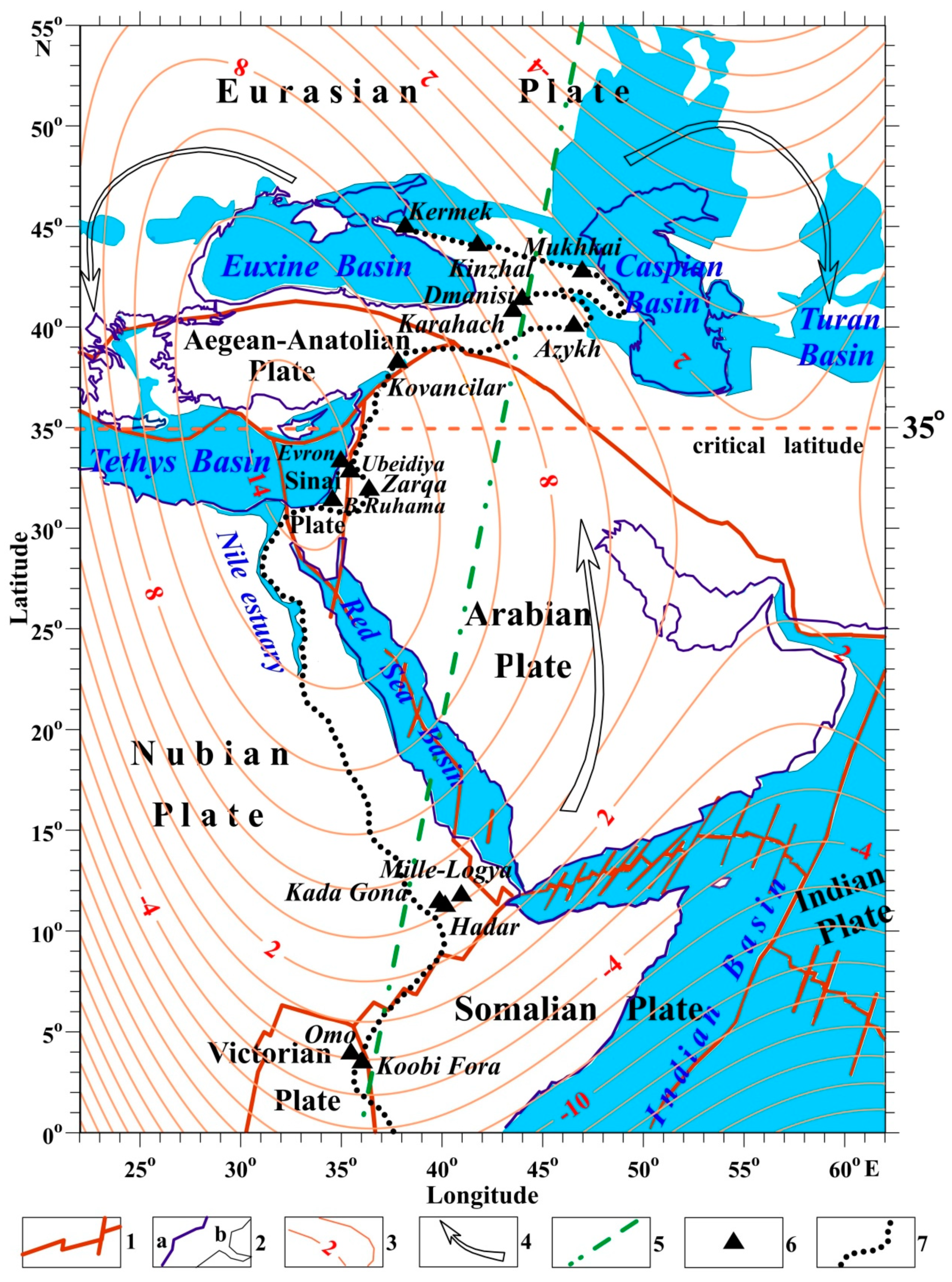
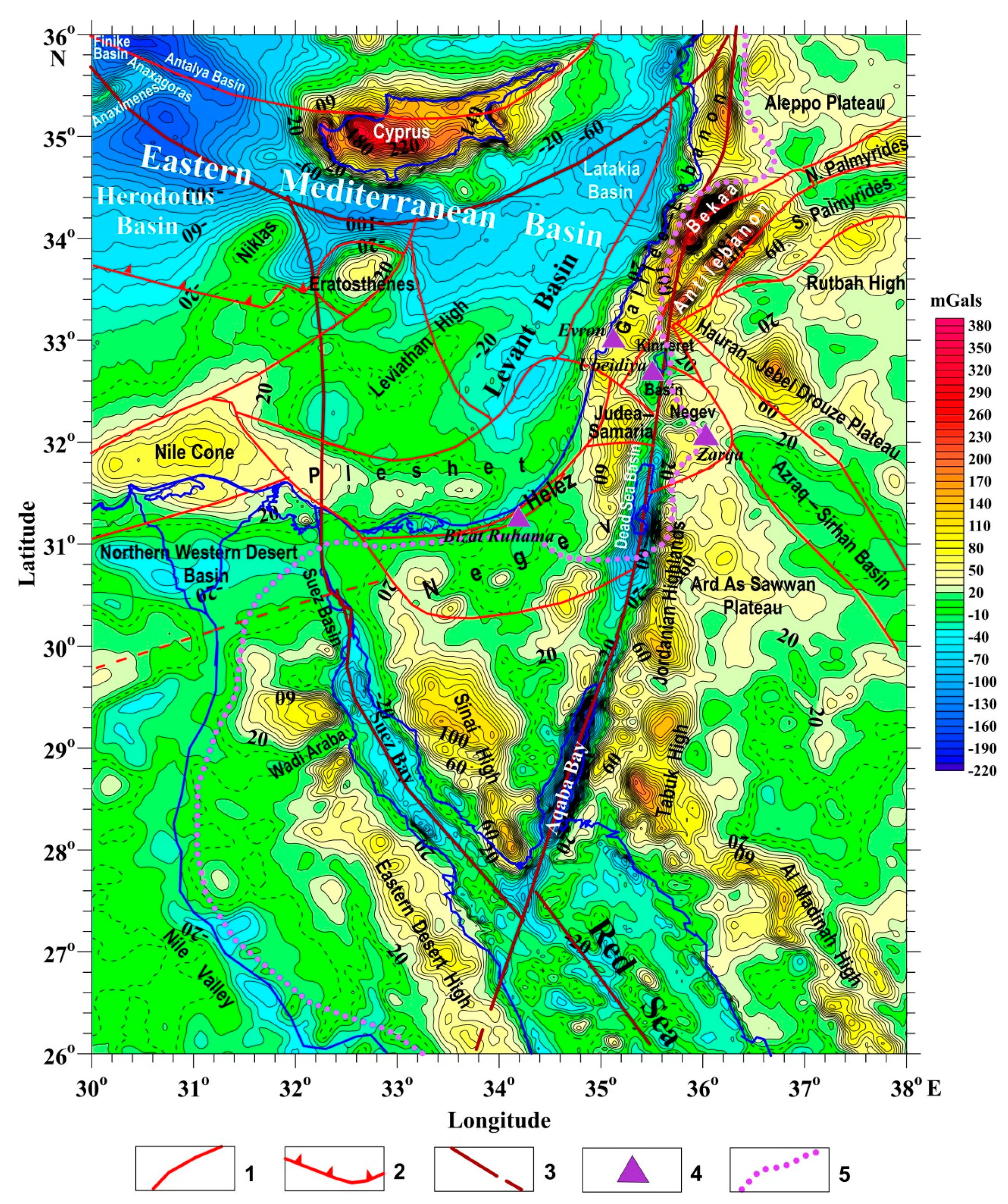
4. Tectonic-Geodynamic Aspects of the Formation of the Levantine Corridor

The reasons that impeded the early dispersal of hominins from Africa to Eurasia were traditionally considered only in terms of changes in climate, landscape, and the nature of the evolution of biotic relationships. From the standpoint of historical planetary science, such an approach seems incomplete both in causal and physical-geographical and historical-evolutionary terms of changes in natural landscapes. In the region under study one of the most difficult ways to overcome natural obstacles was a narrow section of the Eastern Mediterranean—the Levantine Corridor, passing through a very complex geological structure of the Mesozoic Terrane Belt [10] and the regional system of the DST strike-slip depressions. The early dispersal of hominins was hampered by a number of factors. In the period of 4.0–1.0 Ma, the coastal plain of the Eastern Mediterranean was absent. Arid high plateaus and narrow troughs of the arid zone were developed here. In the east, this landscape zone was dissected by the DST strike-slip system. In the northern part of DST, an intense cyclic volcanism of fissure and central types was developed. In the Dead Sea depression, the lowest (−430 m) point of the modern earth′s relief is recorded. In the era of the early dispersal of hominins, other depressions of this zone could have had a compatible hypsometry. All of these features made it difficult for the ancient hominins to live here.
The terrane belt is composed of a series of carbonate platforms—high plateaus covered with Cretaceous and Paleogene limestones. These plateaus are accompanied by the permanent processes of fault tectonics complicating the relief of the dry highlands of these platforms. Before the formation of ancient man, high carbonate plateaus came close to the Mediterranean coast. Erosional canyons of the great Messinian crisis and thick Late Cenozoic terrigenous strata are not developed here, with the exception of the southern part of the Negev terrane [23].
The coastal terranes, partly submerged in the Mediterranean Sea shelf, include Negev, Pleshet, Helez, and Galilee-Lebanon (Figure 3). To the east of them are the Judea-Samaria, Anti-Lebanon, Palmyrides, and Aleppo terranes, which are tectonically disrupted by the DST system; they are elevated desert plateaus and low mountains with periodic winter snow cover.
To the east of the terrane belt, within the Neoproterozoic shield of the Arabian plate, high plateaus (up to 1000–1200 m) are developed—Tabuk, Jordanian, Ard As Sawwan, Hauran-Jebel Drouze, Rutbah, and the Azraq-Sirhan depression (Figure 3) complicated by Late Cenozoic basaltic trap complexes. In the terrane belt, traps are developed mainly in the area adjacent to the DST. It should be noted that the Cretaceous and partly Eocene limestones of the carbonate platform of the terrane belt contain horizons with the siliceous nodules, which makes the Levantine Corridor an advantage as a source of raw materials for the stone industry.
The impassability of the Levantine Corridor for ancient hominins was also associated with a number of other geodynamic factors, in addition to the differentiation of movements in the DST zone and at the boundaries of terranes. Paleomagnetic mapping of the Mt. Carmel area and the Galilee region (coastal part of northern Israel) (Figure 4) also showed a significant differentiation in the direction of tectono-thermal processes from the Late Mesozoic to the Late Cenozoic. This indicates the extreme geodynamic instability of this region and the variety of manifestations of tectonic movements, magmatic processes, and relief with the formation of faults, strike-slip valleys, and rotational structures. The dominant direction of the isopachs of the Lower Cretaceous traps of the Halal-1 superzone corresponds to NNE-SSW. It is 60o counterclockwise as opposed to the development field of the Upper Cretaceous volcanoes of the Halal-2 superzone—NNW-SSE. In turn, the direction of the trap field of the Upper Cenozoic, belonging to the paleomagnetic zone of Sogdiana, the largest in area in the Middle East, the Harrat Ash Shaam patch (covering a total area of about 40,000 km2 [74]) has a length of WNW-ESE. It is 30o counterclockwise compared to the long axis of the Late Cretaceous traps [75] of the Mt. Carmel. These data confirm the regional rotation of the deep mantle structure (Figure 2) over a long geological time, which could not but affect the instability of the structure and ecosystems of the Eastern Mediterranean, and the Levantine Corridor in particular. Diagonal and arc faults, mapped, oppose the boundaries of larger tectonic blocks (terranes) and in recent times have created fault and strike-slip valleys and coastal zones of marching and other landscapes within the early dispersal of hominins along the Levantine Corridor. Horst uplifts with abundant vegetation, such as the present-day Mt. Carmel, could serve as an optimal ecosystem for them on their way to the north [76].
Thus, on the basis of various geodynamic analyzes, for the first time, we draw the attention of anthropologists to the need to combine traditional methods with tectonic-geophysical research, complementing the understanding of the nature of the ecosystems and dispersal routes of the early dispersal of hominins.

5. Akchagylian-Gelasian Hydrospheric Maximum as a Dispersal Barrier in the Early Hominin

Climatic and ecological features as limitations of early hominin dispersal are significant, but unconvincing since the Pliocene epoch inherits the Miocene. These peculiarities were caused by of equatorial transgression and with the limited development of polar glaciations. There were no continental glaciations creating contrasting zonation of climate and ecosystems older that one Ma. Paleogeographically, the Akchagylian-Gelasian seas covered, as in the Miocene, vast shelf spaces, and their hydrospheric maximums reached 200 m above the present-day sea level, and the area of the Paratethys shelf basin was as vast and uniform as in the Miocene. The data of the analysis of the hydrospheric disturbances [30] indicate that the meridian skew of the Earth′s figure with the development of polar transgressions, equatorial compression and continental glaciations occurred at the very end of the Matuyama Epoch, about 844 thousand years ago. Therefore, the separation of some parts of the marine Pliocene and its assignment to the Pleistocene is incorrect from the standpoint of historical planetology.
The essential transgressive maximum was established on the platform in Eurasia, and the marks of the Akchagylian Sea were revealed, reaching +186 m [93]. In the Epipaleozoic platform area of Great Britain [94], the same transgressive maximum reached 180 m. Within the African′s continental plates, similar studies were carried out only in Egypt [95]. It was found that Akchagylian-Gelasian ingressions in the Nile erosional valley reached in the south to the latitude of Sudan and reached elevations of about +200 m. An analysis of all these data [96,97,98] with the paleogeographic reconstructions of the Tethys and Paratethys basins is given in our generalizing work [11].
The materials presented made it possible to carry out special studies indicating the development of marine formations on the shelf of the Eastern Mediterranean in the zone of the future Levantine Corridor.
For many years we have been engaged in regional and local mapping of various regions of Israel using geophysical methods for exploration geophysics [10,99], engineering and geodynamic studies [10,31,32,100,101] and archaeogeophysical investigations [102,103].
For the paleogeographic assessment of the marine transgressions, extensive data of detailed geological surveys at a scale of 1: 50,000 by the Geological Survey of Israel and the materials of our research on geomorphology, ecostratigraphy, and paleoecological analysis of the Pleistocene marine of northern Israel were used. The description and analysis of the research results are given below.
The first structural-geomorphological map of the Mt. Carmel and adjacent areas of Galilee (Figure 5) showed that the tectonic uplift of the Mt. Carmel in the Miocene-Pliocene was an island composed of Cretaceous and partly Paleogene carbonate rocks. At the same time, the Galilee area was lowered and almost completely covered by the Miocene-Pliocene Sea. Based on the analysis of the ages and hypsometry, two terraces are distinguished: low-up to 100–110 m high, and high-up to 200 m high (Figure 5).
Justification of their stratigraphic sequence, age, conditions of formation, and relationship with the continental Calabrian, its artifacts, and remains of the fauna of large mammals became possible thanks to the study of the unique section in the Evron Quarry and its environs (Figure 6). This area (its location is shown in Figure 3) has been studied by many specialists: geologists, paleontologists, archaeologists, petrographers, paleomagnetologists, and researchers in the field of radiometric dating [12,40,41,104,105,106]. There are no analogs of such a section in the world, since the combination of Gelasian marine formations underlain by the trap complex, overlapped by continental formations bearing artifacts and remains of large mammals, is an object of study of supreme importance.
The marine Gelasian occurs on the sediments of the Cretaceous-Eocene carbonate platform. Above these formations are two complexes of Miocene traps, which are the westernmost offshoot of the largest trap field, the Harrat Ash Shaam of the Arabian Plate, as can be seen on the paleomagnetic map (Figure 4). Two complexes are developed here—Middle Miocene Lower basalts with an age of 16.1 Ma (Evron-1) and 14.5 Ma (Evron-3) and Upper Miocene Intermediate basalts with an age of 6.3 Ma (Kabri-15). Early Pliocene Cover basalts are absent in this area, but they occur in the Galilee 17 km southeast of the Kabul area and have a radiometric age of 3.76 Ma, which corresponds to the end of the Early Pliocene or the Gilbert Paleomagnetic Epoch.
According to the chronostratigraphic data, the Lower Akchagylian—Piacenzian is composed of marine formations approximately corresponding to the level of the modern ocean, and these formations are absent on the high plateau of Galilee. Middle Akchagylian forms terraces 100–200 m high, and in the Evron section we see only two strata corresponding to the Mediterranean Gelasian. At the base of the entire marine strata, both Piacenzian and Zanclean are absent, and at the top there are no regressive formations of Upper Akchagylian (Upper Gelasian), and continental analogues of Absheronian (Calabrian of the Mediterranean scale) are developed. It is in the upper part of this stage (according to paleomagnetic data, most likely in the upper part of the Matuyama zone), the layers with artifacts are developed.
Thus, the data for the Evron section allows us to assert that in the Levantine Corridor in the epoch 2.6–2.0 Ma ago on the continental carbonate plateau of the Eastern Mediterranean, a high marine transgression was developed-up to +200 m above the modern sea level. It reached the foot of the carbonate platform of the Mesozoic Terrane Belt, rising to an altitude of 500–2000 m. East of the DST, within the high plateaus of the Neoproterozoic shield of the Arabian lithospheric plate, the Late Cenozoic marine transgressions did not reach [10,107].
To assess the climate of the Akchagylian-Gelasian transgressive maximum epoch in the Eastern Mediterranean, a paleoecological reconstruction of benthic communities in the sea of that stage of the Evron area was carried out (Figure 7). A warm-water association is developed here, in which the attached, drilling, burrowing, wandering sedentary benthos, and the bottom floating organisms are developed. This association is quite comparable with the coastal warm-water association of the modern Mediterranean Sea, which corresponds to the interglacial epoch when there is no continental glaciation. The development in the Evron’s section of carbonate sediments, sharply different from the coastal terrigenous formations of the modern Mediterranean Sea, indicates a milder, warm climate of that time. Consequently, the influence of transgressions on climatic zoning noted far in the north, in Iceland [108,109], in the Eastern Mediterranean was probably not so significant. Here, dispersal restrictions during the ancient hominin dispersal from Africa to Eurasia were determined rather not by the climate, but by the significant peculiarities of paleogeography. We tried to check this proposition on a specially compiled tectonic-paleogeographic map (Figure 8).

6. Discussion and Conclusions

According to tectonic-paleogeographic mapping data (Figure 8), the Levantine Corridor is a rather complex landscape-geodynamic structure and a dispersal ecosystem of a narrowly channeled (linear) type. It is sandwiched between two linear zones, one of which is purely paleogeographic (from the northern part of the Nile estuary in the south to the Levantine coast in the north), and the second has a pronounced geodynamic character and is an extremely active planetary strike-slip zone. The echoes of the movements of this long-developing Eastern Mediterranean Nubian Belt [29] extend from the high plateaus of the Eastern Desert of Egypt, formed by the island-arc and Neoproterozoic ophiolite complex, extending far to the north, into the Alpine region of the Eurasian lithospheric plate. This belt forms the western part of the Caucasian-Arabian syntaxis [110]. The latter is an arcuate zone of accretionary intrusion of the extended Indian plate into the Eurasian one. In the DST belt, intense seismicity and active shear tectonics are developed with the formation of numerous rhomboid graben-like troughs (pull-apart basins) in the zones of the Gulf of Aqaba, the Arava Valley, the Dead Sea area in the south, and the basins of the Lake Kinneret (Sea of Galilee), Hula, and El Gab in the north [23,24].
The thermal springs and the active Pliocene-Quaternary trap magmatism and volcanism are developed in this zone (Figure 5 and Figure 8) in the zone of intersection with the diagonal fields of tectonothermal activation of the Arabian Plate [6,10,100,101]. Obviously, such processes actively influenced the formation of the relief, hydrographic elements, and the nature of the climate and the dynamics of the landscape of this unique narrow zone, close to the coast of the Pliocene-Quaternary Neotethys-Mediterranean basin. The DST area appears to be a significant constraint on the dispersal of ancient hominin [5].
Here, only three Lower Paleolithic sites are known, Ubeidiya (south of the Lake Kinneret), Gesher Benot Ya‘aqov (south of the Hula Basin), and Maayan Baruch (north of the Hula Basin) [76]. And most of the younger stone industry sites are developed in the coastal plain of Israel. In the southern part of the Negev Desert, in the area of erosional-tectonic depressions (makhteshim), no sites of ancient hominin have been found. This circumstance requires further research. Data of paleogeographic and geomorphological studies confirm that the presence of the Late Messinian canyon-type erosional incisions stretching from Beer-Sheva to the Mediterranean Sea [111] limited the penetration of ancient hominin to the north. Apparently, erosional incisions formed estuaries in the Gelasian. To the north of the coastal plain and the Mt. Carmel, on the coastal plateau of the Galilee, a marine basin was developed, whose narrow trough bays probably merged with freshwater streams along with the DST system. The presence of such a connection is evidenced by the finds in the brackish terrigenous strata of this region of shells of marine euryhaline foraminifera [112].
The indicated limiter of hominin dispersal to some extent explains why the earliest finds of artifacts from the Levantine area of ancient hominin aged 2.0–1.78 Ma [7] were found east of the Levantine Corridor in Western Jordan. We assume that this is due to the closure at this time of the Levantine Corridor in the south by the Beer-Sheva estuary, and in the east by the DST estuaries. This assumption is shown in Figure 8. It is possible that immediately after the end of the maximum flooding of the Middle Akchagylian—Middle Gelasian time, the tectonic subsidence of the carbonate platform of the Mesozoic Terrane Belt has already taken place, with the formation of the coastal plain of Israel. And here could be the sites of ancient hominins. Their absence could, in this case, be explained by the fact that they are buried under the younger formations of the continental formations of the Late Calabrian and the strata of the Quaternary terraced fossil dunes (Kurkar). However, such finds have not yet been found, although the sandy, red-colored complexes of the Calabrian, underlying the most ancient layers of the Kurkar, are widely developed in the coastal plain of Israel. We come to the conclusion that this plain was formed in the Quaternary time (in the epoch after 800–850 thousand years ago), as a result of movements associated with the meridian skew and hydroisostasy [55] due to a significant difference (100–120 m) sea levels during the rhythm of changes in the eccentricity of the Earth′s orbit [54].
The fact that it was exactly at the boundary between the Calabrian and Pleistocene (800–900 thousand years ago), that intensive movements took place in the marginal zone of the carbonate platform can be seen in the Gush Dan area (Big Tel Aviv, Israel), on the border between the Pleshet terrane and the raised plateau of the Judea-Samaria terrane (Figure 8). Here, north of the city of Rosh Ain, there are developed near-fault folds in Cretaceous limestones and the fractured zones filled with Calabrian red sands. There are no such formations to the west of the Mt. Carmel. The age of the terraces of the youngest fault step with marks up to 35 m does not exceed 300 thousand years, as evidenced by the marine terraces with the remains of mollusks and large foraminifera [113].
The data of sin-sedimentation tectonics of the Neogene-Quaternary stage (Figure 9) of the Eastern Mediterranean region [10] definitely confirm the uplift of the carbonate platform of the Mesozoic Terrane Belt adjacent to the coastline of the Mediterranean Sea. Equally uplifted were the terrane blocks located east of the DST, as well as the development areas of the Neoproterozoic belt of the Sinai and the Arabian plate, located south of the carbonate platform of the Mesozoic Terrane Belt. The areas of abrupt subsidence in the Late Cenozoic, judging by the drilling data, are the DST rhomboid troughs and the Mediterranean Sea basin, starting approximately from the coastline. A significant difference in thickness of the Late Cenozoic (up to 1500–2000 m) is developed here; magmatic manifestations and zones of tectonic faulting are recorded. Further on the shelf of the Mediterranean Sea, the subsidence increases rather smoothly, and the thickness reaches 3000–4000 m and more (Figure 9).
This indicates a clear stability of the high plateau of the carbonate platform massif in the Neogene. Discordant in relation to it and the Neoproterozoic belt, also elevated up to 1000–2000 m and more in the areas adjacent to the Red Sea rift zone, the zone of deep troughs of the Dead Sea and the Lake Kinneret is developed. Here, the thickness of terrigenous-saline Neogene-Quaternary formations penetrated by traps exceeds 4000–6000 m (Figure 9). Currently, most of the elevated carbonate platform and the Neoproterozoic belt is an arid rocky desert, excluding the lowered coastal plain and mountainous regions. Optimal landscapes for habitation are partly developed in the northern part of the DST. The analysis of sin-sedimentation tectonics leads to an unambiguous conviction about the complexity of the structure, the diversity of landscape, and the narrowness of the optimal ecosystems within the Eastern Mediterranean and the youth of the formation of the ecosystem of the Levantine Corridor. From the east and south, it was adjoined by an arid zone of a vast rocky desert. This factor cannot but be taken into account when analyzing the features of dispersal and settlement of ancient hominins.
Summing up the above, we come to the conviction that the Levantine Corridor in the era of the early hominin development in the area of East Africa had not yet formed as an optimal landscape- dispersal zone, either tectonically or paleogeographically. The dissection of the coastal high plateau of the Eastern Mediterranean with the formation of optimal land landscapes for the habitation of ancient hominins began after regression at the end of Middle Gelasian two Ma ago when the sea level dropped by about 200 m. This concept seems to be consistent with the age of the Lower Paleolithic artifacts. On the other hand, this concept sets out a new strategy for finding them. If new archaeological data is discovered, this approach can be confirmed or significantly adjusted. However, it is obvious that taking into account the diverse complex aspects of the hominin′s dispersal from Africa to Eurasia in this multi-factor complex region will have to be in a wider range.
Thus, the following main conclusions can be formulated:
  • For the first time, significant attention was paid to the tectono-geodynamical peculiarities of the dispersal area of ancient hominins from Africa to Eurasia,
  • It was found that the meridional location of the ancient hominin dispersal, stretching from East Africa to the Caucasus, is associated with the planetary nature of the formation of landscapes and ecosystems, due to the deep-geophysical nature of geodynamics,
  • The dominant influence of the geodynamic changes and hydrospheric fluctuations in the Late Cenozoic on the evolution of the landscape, climate and settlement of populations of ancient humans has been established,
  • The rotation of the deep mantle structure and its effect on the surface (near-surface) layers led to the emergence of the Akchagylian-Gelasian hydrospheric maximum,
  • Revealed the reason for the late development of the Levantine Corridor, due to the development in the great Akchagylian-Gelasian- transgression and the presence of a high coastal plateau of the carbonate platform of the Mesozoic Terrane Belt,
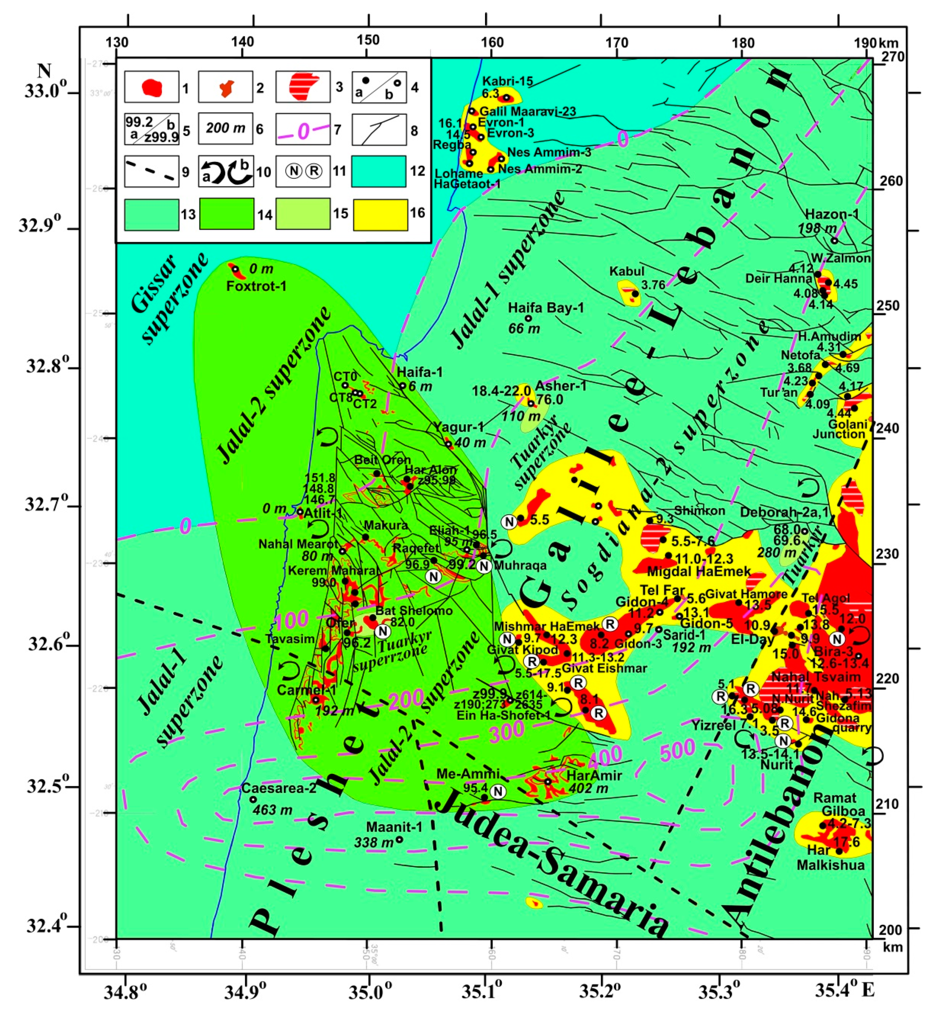
  • The comprehensive study of the Carmel area, displaced at the main direction of the Levantine Corridor during the Pleistocene time, showed that during the early dispersal of hominins from Africa, this area was flooded.

Author Contributions

L.V.E. and Y.I.K.—equivalent contributions to all sections of this paper. All authors have read and agreed to the published version of the manuscript.

Funding

This research received no external funding.

Institutional Review Board Statement

Not applicable.

Informed Consent Statement

Informed consent was obtained from all subjects involved in the study.

Data Availability Statement

The data presented in this study are available on request from the corresponding author.

Acknowledgments

The authors would like to thank four anonymous reviewers, who thoroughly reviewed the manuscript, and their critical comments and valuable suggestions were very helpful in preparing this paper.

Conflicts of Interest

The authors declare no conflict of interest.

References

  1. Bobe, R.; Alemseged, Z.; Behrensmeyer, A.K. Hominin Environments in the East African Pliocene: An Assessment of the Faunal Evidence; Springer: Berlin, Germany; New York, NY, USA, 2007; p. 355. [Google Scholar]
  2. Bobe, R.; Leakey, M.G. Ecology of Plio-Pleistocene Mammals in the Omo–Turkana Basin and the Emergence of Homo. In The First Humans: Origin and Early Evolution of the Genus Homo, Vertebrate Paleobiology and Paleoanthropology; Grine, F.E., Fleagle, J.G., Leakey, R.E., Eds.; Springer: Dordrecht, The Netherlands, 2009; pp. 172–184. [Google Scholar] [CrossRef]
  3. Camps, M.; Chauhan, P. Sourcebook of Paleolithic Transitions; Springer: Dordrecht, The Netherlands, 2009; p. 574. [Google Scholar]
  4. Bar-Yosef, O.; Belmaker, M. Early and Middle Pleistocene faunal and hominins dispersals through Southwestern Asia. Quat. Sci. Rev. 2011, 30, 1281–1295. [Google Scholar] [CrossRef] [Green Version]
  5. Ben-Avraham, Z.; Lazar, M.; Schattner, U.; Marco, M. The Dead Sea Fault and its Effect on Civilization. In Lecture Notes in Earth Sciences Volume 105: Perspectives in Modern Seismology; Wenzel, F., Ed.; Springer: Heidelberg, Germany, 2005; pp. 147–170. [Google Scholar] [CrossRef]
  6. Eppelbaum, L.V.; Katz, Y.I. Deep Tectono-Geodynamic Aspects of Development of the Nubian-Arabian Region. In The Arabian Seas Biodiversity, Environment Challenges and Conservation Measures; Jawad, L., Ed.; Springer: Heidelberg/Berlin, Germany, 2021; pp. 199–237. [Google Scholar] [CrossRef]
  7. Giancarlo, S.; Fabio, P.; Daniel, P.; Miggins, A.; Gerdes, A.; Araujo, G.M.; Walter, A.N.; Gerdes, A.; Araujo, G.M.; Walter, A.N. Chronologic constraints on hominin dispersal outside Africa since 2.48 Ma from the Zarqa Valley, Jordan. Quat. Sci. Rev. 2019, 219, 1–19. [Google Scholar] [CrossRef]
  8. Bar-Yosef, O. Pleistocene connexions between Africa and Southwest Asia: An archaeological perspective. Afr. Archaeol. Rev. 1987, 5, 29–38. [Google Scholar] [CrossRef]
  9. Groucutt, H.S.; White, T.S.; Scerri, E.M.L.; Andrieux, E.; Clark-Wilson, R.; Breeze, P.S.; Armitage, S.J.; Stewart, M.; Drake, N.; Louys, J.; et al. Multiple hominin dispersals into Southwest Asia over the past 400,000 years. Nature 2021, 597, 376–390. [Google Scholar] [CrossRef]
  10. Eppelbaum, L.V.; Katz, Y.I. Eastern Mediterranean: Combined geological-geophysical zonation and paleogeodynamics of the Mesozoic and Cenozoic structural-sedimentation stages. Mar. Pet. Geol. 2015, 65, 198–216. [Google Scholar] [CrossRef]
  11. Eppelbaum, L.; Katz, Y. Akchagylian hydrospheric phenomenon in aspects of deep geodynamics. Stratigr. Sediment. Oil-Gas Basins 2022, 1, 1–19. [Google Scholar]
  12. Ronen, A. The lower palaeolithic site Evron-Quarry in western Galilee, Israel. Sonderveröffentlichungen Geol. Inst. Der Univ. Zu Köln 1991, 82, 187–212. [Google Scholar]
  13. Heimann, A.; Braun, D. Quaternary stratigraphy of the Kinnarot basin, Dead Sea transform, northeastern Israel. Isr. J. Earth Sci. 2000, 49, 31–44. [Google Scholar] [CrossRef]
  14. Goren-Inbar, N.; Alperson, N.; Kislev, M.E.; Simchoni, O.; Melamed, Y.; Ben-Nun, A.; Werker, E. Evidence of hominin control of fire at Gesher Benot Ya‘aqov, Israel. Science 2004, 304, 725–727. [Google Scholar] [CrossRef] [PubMed]
  15. Belmarker, M. Early Pleistocene Faunal Connections between Africa and Eurasia. In An Ecological Perspective. Out of Africa I: The First Hominin Colonization of Eurasia, Vertebrate Paleobiology and Paleoanthropology; Fleagle, J., Shea, J., Grine, F., Baden, A., Leakey, R., Eds.; Springer: Dordrecht, The Netherlands, 2010; pp. 183–205. [Google Scholar] [CrossRef]
  16. Guseinov, M. Ancient Paleolithic of Azerbaijan; Teknur: Baku, Azerbaijan, 2010; p. 200. (In Russian) [Google Scholar]
  17. Leakey, M.G.; Werdelin, L. Early Pleistocene Mammals of Africa: Background to Dispersal. In The First Hominin Colonization of Eurasia; Fleagle, J., Shea, J., Grine, F., Baden, A., Leakey, R., Eds.; Springer: Dordrecht, The Netherlands; Heidelberg, Germany; London, UK; New York, NY, USA, 2010; pp. 3–11. [Google Scholar] [CrossRef]
  18. Davis, M.; Matmon, A.; Fink, D.; Ron, H.; Niedermann, S. Dating Pliocene lacustrine sediments in the central Jordan Valley, Israel—Implications for cosmogenic burial dating. Earth Planet. Sci. Lett. 2011, 305, 317–327. [Google Scholar] [CrossRef] [Green Version]
  19. Trifonov, V.G.; Tesakov, A.S.; Simakova, A.N.; Bachmanov, D.M. Environmental and geodynamic settings of the earliest hominin migration to the Arabian-Caucasus region: A review. Quat. Int. 2019, 534, 116–137. [Google Scholar] [CrossRef]
  20. Ozherel’yev, D.V.; Trifonov, V.G.; Chekik, H.; Trihunkov, Y.I. New Evidence of the Early Paleolithic in the Mountain Systems of Eastern Anatolia and the Lesser Caucasus; Lapshin, V.A., Ed.; Transactions of the Institute for the History of Material Culture of the Russian Academy of Sciiences: Sankt-Petersburg, Russia, 2020; pp. 99–127. (In Russian) [Google Scholar]
  21. Hershkovitz, I.; May, H.; Sarig, R.; Pokhojaev, A.; Grimaud-Hervé, D.; Bruner, E.; Fornai, C.; Quam, R.; Arsuaga, J.L.; Krenn, V.A.; et al. A Middle Pleistocene homo from Nesher Ramla, Israel. Science 2021, 372, 1424–1428. [Google Scholar] [CrossRef]
  22. Schelinsky, B.E. The Early Acheulean of the Western Ciscaucasia; The Institute of the History of Material Culture, Russian Academy of Sciences: Sankt-Petersburg, Russia, 2021; p. 132. (In Russian) [Google Scholar]
  23. Hall, J.K.; Krasheninnikov, V.A.; Hirsch, F.; Benjamini, C.; Flexer, A. The Levantine Basin and Israel. In Geological Framework of the Levant; Historical Productions-Hall: Jerusalem, Israel, 2005; Volume 2, p. 826. [Google Scholar]
  24. Krasheninnikov, V.A.; Hall, J.K.; Hirsch, F.; Benjamini, H.; Flexer, A. Cyprus and Syria. In Geological Framework of the Levant; Historical Productions-Hall: Jerusalem, Israel, 2005; Volume 1, p. 823. [Google Scholar]
  25. Ben-Avraham, Z.; Schattner, U.; Lazar, M.; Hall, J.K.; Ben-Gai, Y.; Neev, D.; Reshef, M. Segmentation of the Levant continental margin, eastern Mediterranean. Tectonics 2006, 25. [Google Scholar] [CrossRef]
  26. Reilinger, R.; McClusky, S.; Vernant, P.; Lawrence, S.; Ergintav, S.; Cakmak, R.; Ozener, H.; Kadirov, F.; Guliev, I.; Stepanyan, R.; et al. GPS constraints on continental deformation in the Africa-Arabia-Eurasia continental collision zone and implications for the dynamics of plate interactions. J. Geophys. Res. Earth Surf. 2006, 111, 1–26. [Google Scholar] [CrossRef]
  27. Stern, R.J.; Johnson, P. Continental lithosphere of the Arabian Plate: A geologic, petrologic, and geophysical synthesis. Earth-Sci. Rev. 2010, 101, 29–67. [Google Scholar] [CrossRef]
  28. Eppelbaum, L.; Katz, Y.; Klokocnik, J.; Kostelecký, J.; Zheludev, V.; Ben-Avraham, Z. Tectonic insights into the Arabian-African region inferred from a comprehensive examination of satellite gravity big data. Glob. Planet. Chang. 2018, 171, 65–87. [Google Scholar] [CrossRef]
  29. Eppelbaum, L.V.; Ben-Avraham, Z.; Katz, Y.I.; Cloetingh, S.; Kaban, M.K. Giant Quasi-Ring Mantle Structure in the African–Arabian Junction: Results Derived from the Geological–Geophysical Data Integration. Geotectonics 2021, 55, 58–82. [Google Scholar] [CrossRef]
  30. Katz, Y.I. Cretaceous Thalassocratic Maximum and Planetary Movements of the Hydrosphere. In Cretaceous Period. Paleogeography and Paleooceanology; Naidin, D.P., Ed.; Nauka: Moscow, Russia, 1986; pp. 191–237. (In Russian) [Google Scholar]
  31. Eppelbaum, L.V.; Katz, Y.I. Key features of seismo-neotectonic pattern of the Eastern Mediterranean. Izvest. Acad. Sci. Azerb. Rep. Ser. Earth Sci. 2012, 3, 29–40. [Google Scholar]
  32. Eppelbaum, L.V.; Katz, Y.I. Paleomagnetic Mapping in Various Areas of the Easternmost Mediterranean Based on an Integrated Geological-Geophysical Analysis. In New Developments in Paleomagnetism Research, Ser: Earth Sciences in the 21st Century; Eppelbaum, L., Ed.; Nova Science Publisher: New York, NY, USA, 2015; pp. 15–52. [Google Scholar]
  33. Segev, A.; Sass, E. Sheet 3-III, Atlit; Geological Map of Israel, Scale 1:50,000; Geological Survey of Israel: Jerusalem, Israel, 2010. [Google Scholar]
  34. Karcz, J.; Sneh, A. Sheet 3-I, Haifa; Geological Map of Israel, Scale 1:50,000; Geological Survey of Israel: Jerusalem, Israel, 2011. [Google Scholar]
  35. Sass, E.; Dekel, A.; Sneh, A. Sheet 5-II, Umm el Fahm; Geological Map of Israel, Scale 1:50,000; Geological Survey of Israel: Jerusalem, Israel, 2013. [Google Scholar]
  36. Sneh, A. Sheet 3-II, Shefar’Am; Geological Map of Israel, Scale 1:50,000; Geological Survey of Israel: Jerusalem, Israel, 2013. [Google Scholar]
  37. Sneh, A. Sheet 3-IV, Nazerat; Geological Map of Israel, Scale 1:50,000; Geological Survey of Israel: Jerusalem, Israel, 2018. [Google Scholar]
  38. Sneh, A.; Sass, E.; Bein, A.; Arad, A.; Rosensaft, M. Sheet 5-I, Hadera; Geological Map of Israel, Scale 1:5000; Geological Survey of Israel: Jerusalem, Israel, 2014. [Google Scholar]
  39. Braun, D.; Ron, H.; Marco, M. Magnetostratigraphy of the hominid tool-bearing Erk el Ahmar Formation in the northern Dead Sea Rift. Isr. J. Earth Sci. 1991, 40, 191–197. [Google Scholar]
  40. Tchernov, E.; Horwitz, L.K.; Ronen, A.; Lister, A. The Faunal Remains from Evron Quarry in Relation to Other Lower Paleolithic Hominid Sites in the Southern Levant. Quat. Res. 1994, 42, 328–339. [Google Scholar] [CrossRef]
  41. Ron, H.; Porat, N.; Ronen, A.; Tchernov, E.; Horwitz, L.K. Magnetostratigraphy of the Evron Member—Implications for the age of the Middle Acheulian site of Evron Quarry. J. Hum. Evol. 2003, 44, 633–639. [Google Scholar] [CrossRef]
  42. Bosworth, W.; Huchon, P.; McClay, K. The Red Sea and Gulf of Aden Basins. J. Afr. Earth Sci. 2005, 43, 334–378. [Google Scholar] [CrossRef]
  43. Vernadsky, W.I. The biosphere and the noosphere. Am. Sci. 1945, 33, 1–12. [Google Scholar]
  44. Lapkin, I.Y.; Katz, Y.I. Geological events at the Carboniferous and Permian boundary. Izvestiya Acad. Sci. USSR 1990, 8, 45–58. [Google Scholar] [CrossRef]
  45. Van Baak, C.G.; Grothe, A.; Richards, K.; Stoica, M.; Aliyeva, E.; Davies, G.R.; Kuiper, K.F.; Krijgsman, W. Flooding of the Caspian Sea at the intensification of Northern Hemisphere Glaciations. Glob. Planet. Chang. 2019, 174, 153–163. [Google Scholar] [CrossRef]
  46. Bobe, R.; Behrensmeyer, A.K.; Chapman, R.E. Faunal change, environmental variability and Late Pliocene hominin evolution. J. Hum. Evol. 2002, 42, 475–497. [Google Scholar] [CrossRef] [PubMed] [Green Version]
  47. Rogers, M.J.; Semaw, S. From Nothing to Something: The Appearance and Context of the Earliest Archaeological Record. In Sourcebook of Paleolithic Transitions; Camps, M., Chauhan, P., Eds.; Springer: New York, NY, USA, 2009; pp. 155–171. [Google Scholar] [CrossRef]
  48. Dennell, R. “Out of Africa I”: Current Problems and Future Prospects. In Out of Africa I. The First Hominin Colonization of Eurasia; Delson, E., Sargis, E., Eds.; Springer: Dordrecht, The Netherlands; Heidelberg, Germany, 2010; pp. 247–274. [Google Scholar] [CrossRef]
  49. Böhme, M.; Spassov, N.; Majidifard, M.R.; Gärtner, A.; Kirscher, U.; Marks, M.; Dietzel, C.; Uhlig, G.; El Atfy, H.; Begun, D.R.; et al. Neogene hyperaridity in Arabia drove the directions of mammalian dispersal between Africa and Eurasia. Commun. Earth Environ. 2021, 2, 1–13. [Google Scholar] [CrossRef]
  50. Gowlett, J.A.J. The Longest Transition or Multiple Revolutions? Curves and Steps in the Record of Human Origins. In Sourcebook of Paleolithic Transitions; Camps, M., Chauhan, P., Eds.; Springer: Dordrecht, The Netherlands, 2009; pp. 65–77. [Google Scholar] [CrossRef]
  51. Hlubik, S.; Cutts, R.; Braun, D.R.; Berna, F.; Feibel, C.S.; Harris, J.W.K. Hominin fire use in the Okote member at Koobi Fora, Kenya: New evidence for the old debate. J. Hum. Evol. 2019, 133, 214–229. [Google Scholar] [CrossRef] [PubMed]
  52. Fleagle, J.G.; Shea, J.J.; Grine, F.E.; Baden, A.L.; Leakey, R.E. An Ecological Perspective. Out of Africa I: The First Hominin Colonization of Eurasia, Vertebrate Paleobiology and Paleoanthropology. In Sourcebook of Paleolithic Transitions; Springer: Dordrecht, The Netherlands, 2010; p. 304. [Google Scholar]
  53. de Menocal, P.B. African climate change and faunal evolution during the Pliocene-Pleistocene. Earth Planet. Sci. Lett. 2004, 220, 3–24. [Google Scholar] [CrossRef]
  54. Milankovitsch, M. Canon of Insolation and the Ice-Age Problem; Special Publication of the Royal Serbian Academy: Belgrad, Serbia, 1941; Volume 132, p. 634. [Google Scholar]
  55. Morner, N.-A. Earth Rheology, Isostasy and Eustasy; Wiley: Chichester, UK, 1980; p. 599. [Google Scholar]
  56. Behrensmeyer, A.K.; Bobe, R.; Alemseged, Z. Approaches to the analysis of faunal change during the East African Pliocene. In Hominin Environments in the East African Pliocene: An Assessment of the Faunal Evidence; Vertebrate Paleobiology and Paleoanthropology Series; Bobe, R., Alemseged, Z., Behrensmeyer, A.K., Eds.; Springer: Heidelberg, Germany; New York, NY, USA, 2007; Volume 1, pp. 1–24. [Google Scholar] [CrossRef]
  57. Gibbard, P.L.; Bauer, A.M.; Edgeworth, M.; Ruddiman, W.F.; Gill, J.L.; Merritts, D.J.; Finney, S.C.; Edwards, L.E.; Walker, M.J.C.; Maslin, M.; et al. A practical solution: The Anthropocene is a geological event, not a formal epoch. Episodes 2021, 15, 1–12. [Google Scholar] [CrossRef]
  58. Dodonov, A.E. Anthropogene of South. Tadjikistan; Academy of Sciences of the USSR; Nauka: Moscow, Russia, 1986; p. 168. (In Russian) [Google Scholar]
  59. Veronnet, A.A. Rotation de l’Ellipsoide Heterogene et Figure Exacte de la Terre. J. Math. Pures Appl. 1912, 8, 331–463. (In French) [Google Scholar]
  60. Eppelbaum, L.V.; Ben-Avraham, Z.; Katz, Y.; Cloetingh, S.; Kaban, M. Combined multifactor evidence of a giant lower-mantle ring structure below the Eastern Mediterranean. Position 2020, 11, 11–32. [Google Scholar] [CrossRef] [Green Version]
  61. Belyaeva, E.V.; Tesakov, A.S. The Early Paleolithic Sites and Environments of the Caucasus and Adjacent Areas in the Early-Middle Pleistocene; Russian Academy of Sciences: Sankt-Petersburg, Russia, 2020; p. 142. (In Russian) [Google Scholar]
  62. Grine, F.E.; Leakey, M.G.; Gathago, P.N.; Brown, F.H.; Mongle, C.; Yang, D.; Jungers, W.L.; Leakey, L.N. Complete permanent mandibular dentition of early Homo from the upper Burgi Member of the Koobi Fora Formation, Ileret, Kenya. J. Hum. Evol. 2019, 131, 152–175. [Google Scholar] [CrossRef]
  63. McDougall, I.; Brown, F.H.; Fleagle, J.G. Sapropels and the age of hominins Omo I and II, Kibish, Ethiopia. J. Hum. Evol. 2008, 55, 409–420. [Google Scholar] [CrossRef]
  64. Johanson, D. The paleoanthropology of Hadar, Ethiopia. Comptes Rendus Palevol. 2017, 16, 140–154. [Google Scholar] [CrossRef]
  65. Alemseged, Z.; Wynn, J.G.; Geraads, D.; Reed, D.; Barr, W.A.; Bobe, R.; McPherron, S.P.; Deino, A.; Alene, M.; Sier, M.J.; et al. Fossils from Mille-Logya, Afar, Ethiopia, elucidate the link between Pliocene environmental changes and Homo origins. Nat. Commun. 2020, 11, 1–12. [Google Scholar] [CrossRef] [PubMed]
  66. Semaw, S. The World’s Oldest Stone Artefacts from Gona, Ethiopia: Their Implications for Understanding Stone Technology and Patterns of Human Evolution between 2.6–1.5 Million Years Ago. J. Arch. Sci. 2000, 27, 1197–1214. [Google Scholar] [CrossRef] [Green Version]
  67. Semaw, S.; Simpson, S.W.; Quade, J.; Renne, P.R.; Butler, R.F.; McIntosh, W.C.; Levin, N.; Dominguez-Rodrigo, M.; Rogers, M.J. Early Pliocene hominids from Gona, Ethiopia. Nature 2005, 433, 301–305. [Google Scholar] [CrossRef] [PubMed]
  68. Belmaker, M.; O’Brien, H.D. Mesowear study of ungulates from the Early Pleistocene site of ‘Ubeidiya (Israel) and the implications for early Homo dispersal from Africa. Quat. Int. 2018, 480, 66–77. [Google Scholar] [CrossRef]
  69. Belyaeva, E.V. History of Acheulean studies in Armenia and V.P. Lyubin’s contribution. In The Earliest Occupation of the Caucasian Region; Lapshin, V.A., Ed.; Transactions of the Institute for the History of Material Culture of Russian Academy of Sciences: St. Petersburg, Russia, 2020; pp. 55–69. (In Russian) [Google Scholar]
  70. Lordkipanidze, D.; Jashashvili, T.; Vekua, A.; De León, M.S.P.; Zollikofer, C.P.E.; Rightmire, G.P.; Pontzer, H.; Ferring, R.; Oms, O.; Tappen, M.; et al. Postcranial evidence from early Homo from Dmanisi, Georgia. Nature 2007, 449, 305–310. [Google Scholar] [CrossRef]
  71. Garcia, T.; Féraud, G.; Falgueres, C.; De Lumley, H.; Perrenoud, C.; Lordkipanidze, D. Earliest human remains in Eurasia: New 40Ar/39Ar dating of the Dmanisi hominid-bearing levels, Georgia. Quat. Geochronol. 2010, 5, 443–451. [Google Scholar] [CrossRef]
  72. Amirkhanov, H.A. Paleolithic culture of the Caucasus at the end of the Eopleistocene: Oldovan, Early Acheulean, transitional stage? Russ. Geol. 2020, 2, 7–21. [Google Scholar]
  73. Sablin, M.V. Fauna of the Mukhkai 2 site. In The Earliest Occupation of the Caucasian Region; Lapshin, V.A., Ed.; Transactions of the Institute for the History of Material Culture of Russian Academy of Sciences: St. Petersburg, Russia, 2020; pp. 176–186. (In Russian) [Google Scholar]
  74. Weinstein, Y.; Navon, O.; Lang, B. Fractionation of Pleistocene alkali-basalts from the northern Golan Heights, Israel. Isr. J. Earth Sci. 1994, 43, 63–79. [Google Scholar]
  75. Katz, Y.I.; Eppelbaum, L.V. Preliminary results of basin mapping of the Lower Cretaceous traps in northern Israel. In Proceedings of the Transactions of the Conference of the Israel Geological Society, Annual Meeting, Dead Sea, Israel, 18 March 1999; p. 40. [Google Scholar]
  76. Kübler, S.; King, G.C.P.; Devès, M.H.; Inglis, R.H.; Bailey, G.N. Tectonic Geomorphology and Soil Edaphics as Controls on Animal Migrations and Human Dispersal Patterns. In Geological Setting, Palaeoenvironment and Archaeology of the Red Sea; Rasul, N.M.A., Stewart, I.C.F., Eds.; Springer: Berlin, Germany; New York, NY, USA, 2019; pp. 653–673. [Google Scholar] [CrossRef]
  77. Nur, A.; Helsley, C.E. Paleomagnetism of Tertiary and recent lavas of Israel. Earth Planet. Sci. Lett. 1971, 10, 375–379. [Google Scholar] [CrossRef]
  78. Lang, B.; Mimran, Y. An Early Cretaceous volcanic sequence in central Israel and its significance to the absolute date of the base of the Cretaceous. J. Geol. 1985, 93, 179–184. [Google Scholar] [CrossRef]
  79. Lang, B.; Steinitz, G. K-Ar dating of Mesozoic magmatic rocks in Israel: A review. Isr. J. Earth Sci. 1989, 38, 89–103. [Google Scholar]
  80. Nur, A.; Ron, H.; Scott, O. Mechanics of distributed fault and block rotation. In Paleomagnetic Rotations and Continental Deformation; Kissel, C., Laj, C., Eds.; NATO ASI Series: Mathematics and Physical Sciences; Kluwer Academic: Dordrecht, The Netherlands; Boston, MA, USA; London, UK, 1989; pp. 209–228. [Google Scholar]
  81. Shaliv, G. Stages in the Tectonics and Volcanic History of the Neogene Basalt in the Lower Galilee and the Valleys. Ph.D. Thesis, Hebrew University, Jerusalem, Israel, 1991. [Google Scholar]
  82. Mor, D. A time-table for the Levant volcanic province, according to K-Ar dating in the Golan Heights, Israel. J. Afr. Earth Sci. 1993, 16, 223–234. [Google Scholar] [CrossRef]
  83. Heimann, A.; Stenitz, G.; Mor, D.; Shaliv, G. The Cover Basalt Formation, its age and its regional and tectonic setting: Implications from K-Ar and 40Ar/39Ar geochronology. Israel J. Earth Sci. 1996, 45, 55–71. [Google Scholar]
  84. Sneh, A.; Bartov, Y.; Weissbrod, T.; Rosensaft, M. Geological Map of Israel, 1:200,000 (4 Sheets); Geological Survey of Israel: Jerusalem, Israel, 1998. [Google Scholar]
  85. Segev, A. Synchronous magmatic cycles during the fragmentation of Gondwana: Radiometric ages from the Levant and other provinces. Tectonophysics 2000, 325, 257–277. [Google Scholar] [CrossRef]
  86. Segev, A.; Sass, E. The geology of the Carmel region, Albian-Turonian volcano-sedimentary cycles on the northwestern edge of the Arabian platform. Rep. Isr. Geol. Soc. 2009, GSI/7/2009, 1–77. [Google Scholar]
  87. Segev, A.; Sass, E.; Ron, H.; Lang, B.; Kolodny, Y.; McWilliams, M. Stratigraphic, geochronologic, and paleomagnetic constraints on Late Cretaceous volcanism in northern Israel. Isr. J. Earth Sci. 2002, 51, 297–309. [Google Scholar] [CrossRef]
  88. Ilani, S.; Kafri, U.; Harlavan, Y. Miocene volcanism in the Western Galilee coastal plain. Isr. J. Earth Sci. 2005, 54, 47–53. [Google Scholar] [CrossRef]
  89. Ilani, S.; Kafri, U.; Harlavan, Y. Campanian volcanism within the Asher-1 borehole. Isr. J. Earth Sci. 2005, 54, 179–181. [Google Scholar] [CrossRef]
  90. Kaminchik, J.; Segev, A.; Katzir, Y. The Origin of Intraplate Alkaline Mafic Magmatism in Continental Shelves: Lavas and Xenoliths from the Upper Cretaceous Volcanos of Mt Carmel. Master’s Thesis, Beer-Sheva University, Beer-Sheva, Israel, 2014. [Google Scholar]
  91. Dembo, N.; Hamiel, Y.; Granot, R. Intraplate Rotational Deformation Induced by Faults: Carmel-Gilboa Fault System as a Case Study; Report No. GSI/19/2015; Geological Survey of Israel: Jerusalem, Israel, 2015; p. 32. [Google Scholar]
  92. Griffin, W.; Gain, S.; Huang, J.-X.; Belousova, E.; Toledo, V.; O’Reilly, S. Permian to Quaternary magmatism beneath the Mt Carmel area, Israel: Zircons from volcanic rocks and associated alluvial deposits. Lithos 2018, 314–315, 307–322. [Google Scholar] [CrossRef]
  93. Vostryakov, A.V. Buried and accumulative surfaces of denudation of the Southern Zavolzhye. In The Problems of the Denudation Plains; Gerasimov, I.P., Meshcheryakov, Y.A., Vostryakov, A.V., Gorelov, S.K., Dumitrashko, N.V., Korzhenevsky, A.A., Naumov, A.D., Timofeyev, D.A., Eds.; Nauka: Moscow, Russia, 1964; pp. 107–115. (In Russian) [Google Scholar]
  94. Bennison, G.M.; Wright, A.E. The Geological History of the British Isles; Dept. of Geology, University of Birmingham: London, UK, 1969; p. 143. [Google Scholar]
  95. Chumakov, I.S. Pliocene and Pleistocene deposits of the Nile Valley in Nubia and Upper Egypt; Transactions of the Geological Institute of Russian Academy of Sciences; Nauka: Moscow, Russia, 1967; Volume 170, p. 115. (In Russian) [Google Scholar]
  96. Clauzon, G.; Suc, J.-P.; Dumurdžanov, N.; Melinte-Dobrinescu, M.C.; Zagorchev, I. The Pliocene Gilbert-type fan delta of draĉevo (Skopje area, Republic of Macedonia): Paleogeographic inference. Geol. Maced. 2008, 2, 21–28. [Google Scholar]
  97. Richards, K.; van Baak, C.G.C.; Athersuch, J.; Hoyle, T.M.; Stoica, M.; William, E.N.; Austin, W.E.H.; Cage, A.G.; Wonders, A.A.H.; Marreti, F.; et al. Palynology and micropalaeontology of the Pliocene—Pleistocene transition in outcrop from the western Caspian Sea, Azerbaijan: Potential links with the Mediterranean, Black Sea and the Arctic Ocean? Palaeogeogr. Palaeoclimatol. Palaeoecol. 2018, 511, 119–143. [Google Scholar] [CrossRef] [Green Version]
  98. Krijgsman, W.; Tesakov, A.; Yanina, T.; Lazarev, S.; Danukalova, G.; van Baak, C.; Agustí, J.; Alçiçek, M.; Aliyeva, E.; Bista, D.; et al. Quaternary time scales for the Pontocaspian domain: Interbasinal connectivity and faunal evolution. Earth-Sci. Rev. 2019, 188, 1–40. [Google Scholar] [CrossRef]
  99. Eppelbaum, L.; Katz, Y. Tectonic-Geophysical Mapping of Israel and Eastern Mediterranean: Implication for Hydrocarbon Prospecting. Positioning 2011, 2, 36–54. [Google Scholar] [CrossRef] [Green Version]
  100. Eppelbaum, L.; Ben-Avraham, Z.; Katz, Y. Integrated analysis of magnetic, paleomagnetic and K-Ar data in a tectonic complex region: An example from the Sea of Galilee. Geoph. Res. Lett. 2004, 31, L19602. [Google Scholar] [CrossRef]
  101. Eppelbaum, L.; Ben-Avraham, Z.; Katz, Y. Structure of the Sea of Galilee and Kinarot Valley derived from combined geological-geophysical analysis. First Break 2007, 25, 21–28. [Google Scholar] [CrossRef]
  102. Eppelbaum, L.V. Archaeological geophysics in Israel: Past, Present and Future. Adv. Geosci. 2010, 24, 45–68. [Google Scholar] [CrossRef] [Green Version]
  103. Eppelbaum, L.V.; Khesin, B.E.; Itkis, S.E. Archaeological geophysics in arid environments: Examples from Israel. J. Arid Environ. 2010, 74, 849–860. [Google Scholar] [CrossRef]
  104. Issar, A.; Kafri, U. The discovery of a Pleistocene mammalian fauna and artefacts at Evron, Western Galilee. Isr. J. Earth Sci. 1969, 18, 147. [Google Scholar]
  105. Ronen, A.; Amiel, A. The Evron Quarry: A contribution to the Quaternary stratigraphy of the coastal Plain of Israel. Paléorient 1974, 2, 167–173. [Google Scholar] [CrossRef]
  106. Porat, N.; Ronen, A. Luminescence and ESR age determinations of the Lower Paleolithic site Evron Quarry, Israel. Adv. ESR Appl. 2002, 18, 123–130. [Google Scholar]
  107. Gvirtzman, G.; Buchbinder, B. Outcrops of neogene formation in the central and southern coastal plain Hashefela and Beer Sheva regions, Israel. Geol. Surv. Israel Bull. 1969, 50, 1–76. [Google Scholar]
  108. Einarsson, T. Magneto-geological mapping in Iceland with the use of a compass. Philos. Mag. 1957, 6, 232–239. [Google Scholar] [CrossRef]
  109. Gladenkov, Y.B. Pliocene-Anthropogene. In Iceland and the Mid-Ocean Ridge. Stratigraphy and Lithology; Nauka: Moscow, Russia, 1978; pp. 62–85. (In Russian) [Google Scholar]
  110. Sharkov, E.V. Caucasian-Arabian Syntaxis, The Alpine-Himalayan Continental Collisional Zone. In The Structural Geology Contribution to the Africa-Eurasia Geology: Basement and Reservoir Structure, Ore Mineralization and Tectonic Modelling; Rosetti, F., Blanc, A.C., Riguzzi, F., Leroux, E., Pavlopoulos, K., Bellier, O., Kapsimalis, V., Eds.; Springer: Heidelberg, Germany; New York, NY, USA, 2019; pp. 311–314. [Google Scholar] [CrossRef]
  111. Buchbinder, B.; Zilberman, E. Sequence stratigraphy of Miocene-Pliocene carbonate-siliciclastic shelf deposits in the eastern Mediterranean margin (Israel): Effects of eustasy and tectonics. Sediment. Geol. 1997, 112, 7–32. [Google Scholar] [CrossRef]
  112. Almogi-Labin, A.; Siman-Tov, R.; Rosenfeld, A.; Debard, E. Occurrence and distribution of the foraminifer Ammonia beccarii tepida (Cushman) in water bodies, recent and quaternary, of the Dead Sea rift, Israel. Mar. Micropaleontol. 1995, 26, 153–159. [Google Scholar] [CrossRef]
  113. Michelson, H. Pleistocene tectonic movements in the Coastal Plain of Israel emphasizing the Mount Carmel area: A Discussion. Isr. J. Earth Sci. 1971, 20, 129–132. [Google Scholar]
Figure 1. Geomorphological-paleogeographic map of the study area with the main tectonic elements and modern topography map. (1) ancient hominin sites of 2.6–1.2 Ma, (2) reconstructed ancient hominin way from Africa to Eurasia.
Geosciences 12 00021 g001
Figure 2. Satellite-derived gravity map with the paleogeographical, tectonic-geodynamic elements and anthropological features. (1) interplate faults, (2) a: modern land-sea boundaries, b: land-sea boundaries during the maximum Akchagylian-Gelasian transgression, (3) residual satellite-derived gravity map, (4) rotation of the Earth′s crust according to the GPS observations, paleomagnetic and structural data, (5) averaged position of the Ural-African Step, (6) ancient hominin sites corresponding to the age Akchagylian-Gelasian transgression, (7) reconstructed early hominin way from Africa to Eurasia ((3) and (4) according to [26,29,60]).
Geosciences 12 00021 g002
Figure 3. Geodynamic-paleogeographic map of the African-Arabian region with the main tectonic elements and ancient hominin sites. (1) interplate faults, (2) Mediterranean Ridge, (3) intraplate faults, (4) ancient hominin sites corresponding to the age of the Post-Gelasian regression, (5) reconstructed early hominin way from Africa to Eurasia.
Geosciences 12 00021 g003
Figure 4. Geodynamic-paleomagnetic map of the Mt. Carmel—Galilee region (northern Israel). The following main works were used for this map construction: [10,32,33,34,35,36,37,38,75,77,78,79,80,81,82,83,84,85,86,87,88,89,90,91,92]. (1) Cretaceous-Miocene basalts, (2) Miocene gabbroid intrusive, (3) Pliocene Cover basalts, (4) outcrops: (a) and boreholes, (b) with the Mesozoic-Cenozoic magmatic complexes, (5) radiometric age of magmatic rocks and minerals from K-Ar, Ar-Ar methods (a) and zircon geochronology (b), (6) thickness of the Lower Cretaceous traps (in m), (7) isolines of the Lower Cretaceous traps thicknesses (in m), (8) faults, (9) boundaries of terranes, (10) counterclockwise (a), and clockwise (b) rotation derived from the tectonic and paleomagnetic data, (11) data of paleomagnetic measurements of magmatic rocks with the normal (N) and reverse (R) polarities, (12–15) paleomagnetic superzones: (12) Gissar, (13) Jalal-1, (14) Jalal-2, (15) Tuarkyr, (16) Sogdiana-2.
Geosciences 12 00021 g004
Figure 5. Structural-geomorphological map of the Mt. Carmel area (northern Israel). The following main works were used for this map construction: [33,34,35,36,37,38]. (1) faults, (2) counterclockwise rotation of tectonic blocks, (3) high-level Pliocene marine terrace, (4) points with the Pliocene abrasion conglomerates, (5) Pliocene marine sediments of the Pleshet Formation, (6) Late Miocene marine sediments of the Bira and Patish Formations, (7) Middle Miocene marine sediments of the Ziqlag Formation, (8) most high level of the marine Pliocene transgression (boundary indicating the position of the Miocene islands within the Pliocene marine environments), (9) modern hypsometric data of the Miocene-Pliocene sediments, (10) highest hypsometric points of the tectonically uplifted Miocene marine terraces.
Geosciences 12 00021 g005
Figure 6. The stratigraphic sequence of the Upper Cenozoic sediments and traps of the Evron Quarry area in northern Galilee (northern Israel). Besides the personal studies of the authors of this paper, the following main works were used for this section construction: [12,15,40,41,88,104,105].
Geosciences 12 00021 g006
Figure 7. Paleoecological reconstructions of the Early Gelasian (Pleshet stage) marine benthic association of the Evron quarry in northern Galilee (northern Israel) (this figure is composed using the personal experience of the authors). (1) Scleractinian corals (Cladocora sp.), (2) Polychaeta worms (Serpula, Spirorbis), (3) Bryozoa, (4) Echinoidea, (5) Gastropod mollusks (Vermetus, Natica and oth.), (6)–(8) Bivalvian mollusks: (6) Pectinidae, (7) Cardiiidae, (8) Lithophaga, (9)–(11): Arthropods: (9) Creusia, (10) Balanus, (11) Crabs, (12) Fishes, (13)–(14) marine Plants: (13) Lithotamnion biogenic carbonates, (14) thalloid Chlorophycea.
Geosciences 12 00021 g007
Figure 8. Map of the Levantine Corridor with the significant tectono-geological elements. (1) interplate faults, (2) Mediterranean Ridge, (3) intraplate faults, (4) Pliocene trap fields, (5) Pliocene-Pleistocene volcanoes, (6) ancient hominin sites, (7) Levantine Corridor.
Geosciences 12 00021 g008
Figure 9. Map of the Neogene-Quaternary structural stage of the Eastern Mediterranean with some anthropological features (significantly revised and supplemented after [10]). (1) coastline, (2) main faults, (3) secondary faults, (4) borehole (outcrop) location, (5) local ring structures, (6) reconstructed early hominin way from Africa to Eurasia, (7) ancient hominin sites.
Geosciences 12 00021 g009
Table 1. Location and age of the well-studied African-Levantine-Caucasian anthropological sites.
Name of SiteAge, Ma *Geographic LocationCoordinatesAuthorTectono-Geodynamical Zone (According to the Authors of the Article)
Koobi Fora2.1–1.6East of the Lake Turkana, Kenya 3.9482° N 36.1864° E [62]East African Rift Belt
Omo2.4–2.3Southern part of the Omo River, south-western Ethiopia4.4875° N
35.5886° E
[47,63]
Hadar2.4–2.3Afar area, Ethiopia11.0960° N,
40.3760° E
[64]
Mille-Logya2.43–2.1Afar area, Ethiopia11.435° N
40.753° E
[65]
Kada Gona2.6–2.0Awash River area, Ethiopia11.1486° N
40.3233° E
[66,67]
Bizat Ruhama1.0–0.6Near Kibbutz Ruhama, northern Negev, Israel31.502° N
34.705° E
[15]Carbonate platform of the Mesozoic Terrane Belt of the Levant
Zarqa2.0–1.95North-western Jordan32.2039° N
36.0089° E
[7]
Ubeidiya1.6–1.4Kinneret Basin, Israel32.6897° N
35.5565° E
[68]
Evron1.1–0.9North of Carmel area, northern Israel32.987° N 35.1167° E[40,41]
Kovancilar 2.0–1.7Kovancilar town, Taurus Mts., south-eastern Turkey38.4195° N, 39.5170° E[19,20] East Anatolian-Caucasian zone of the Alpine orogen
Azykh>1.2Khojavend district of Azerbaijan39.8167° N 46.7500° E[16]
Karakhach1.85–1.78Mt. Karakach, Lesser Caucasus, Armenia41.07379° N
44.12063° E
[69]
Dmanisi1.85–1.77Dmanisi town, western Georgia41.33611° N
44.34389° E
[70,71]
Mukhkai>1.95
2.1–1.77
North-eastern Caucasus, Dagestan, Russia 42.1446° N 47.2131° E[72,73]
KinzhalAcheulianNorthern Caucasus, MinVody, Russia44.269° N 43.017° E[61]
Kermek2.1–1.95North-western Caucasus, Taman Peninsula, Russia45.3575° N
37.1030° E
[22]
* The age of site is given not by the age of the outcrops, but by the age of the recognized artifacts.
Publisher’s Note: MDPI stays neutral with regard to jurisdictional claims in published maps and institutional affiliations.

