
Human Footprints in the Karst Landscape: The Influence of Lime Production on the Landscape of the Northern Dalmatian Islands (Croatia)


Abstract
:1. Introduction
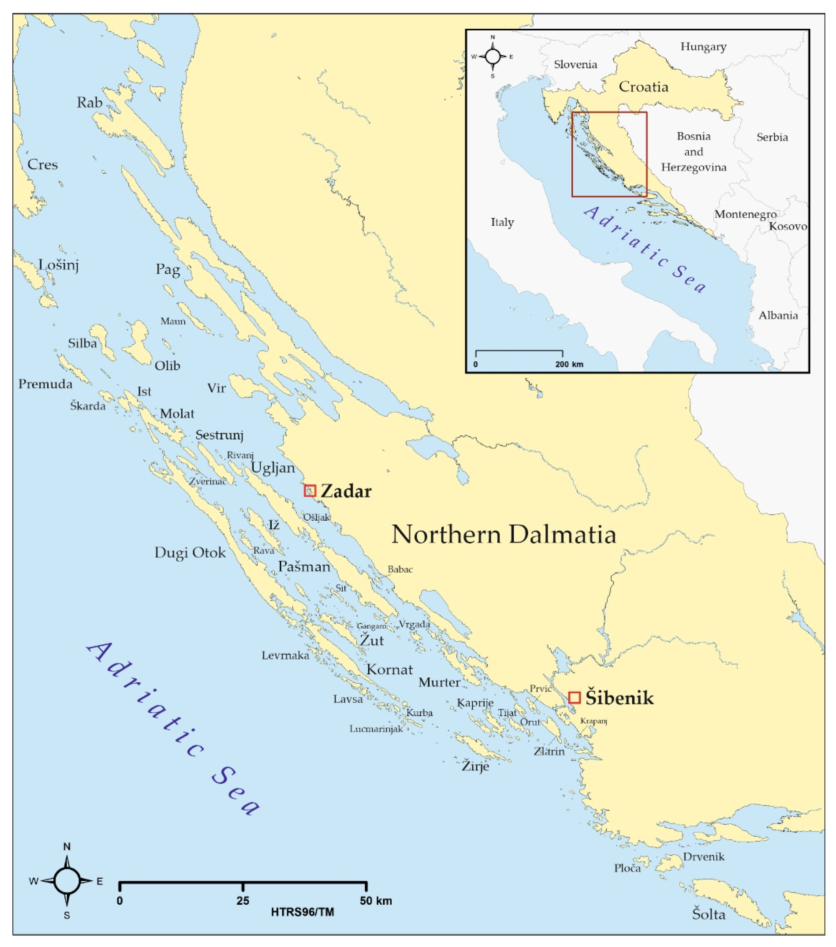
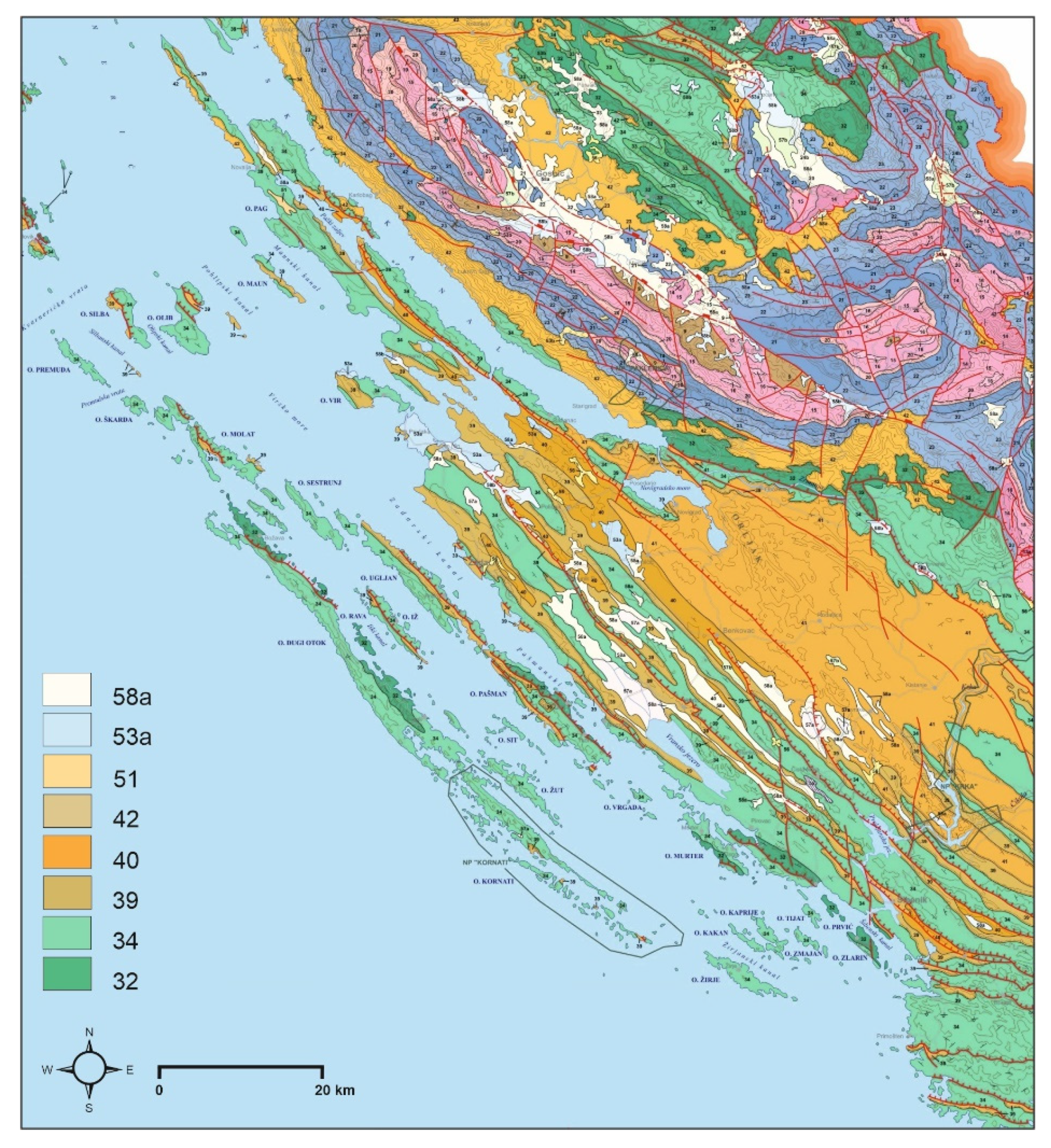
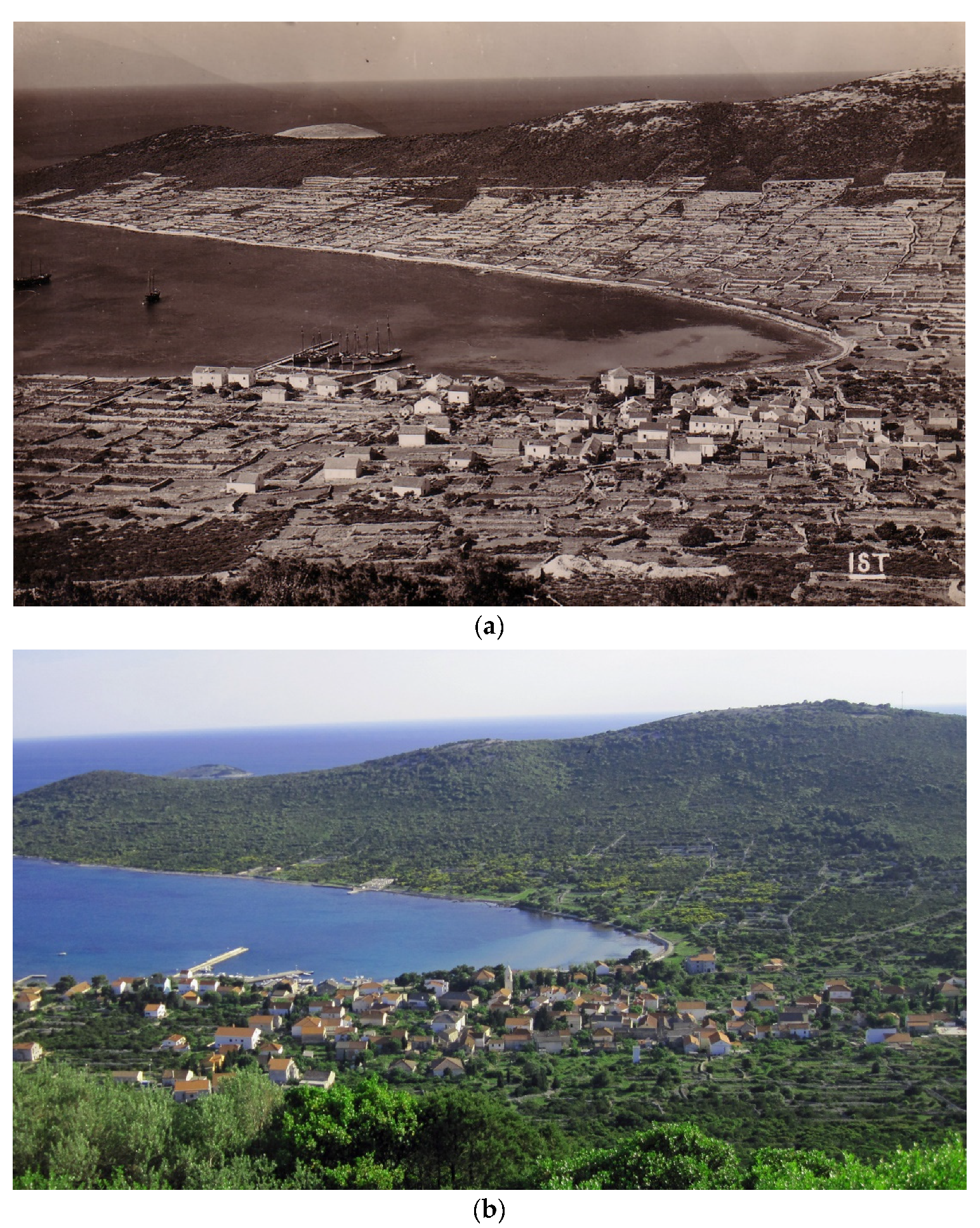
2. Study Site
3. Materials and Methods
4. Results
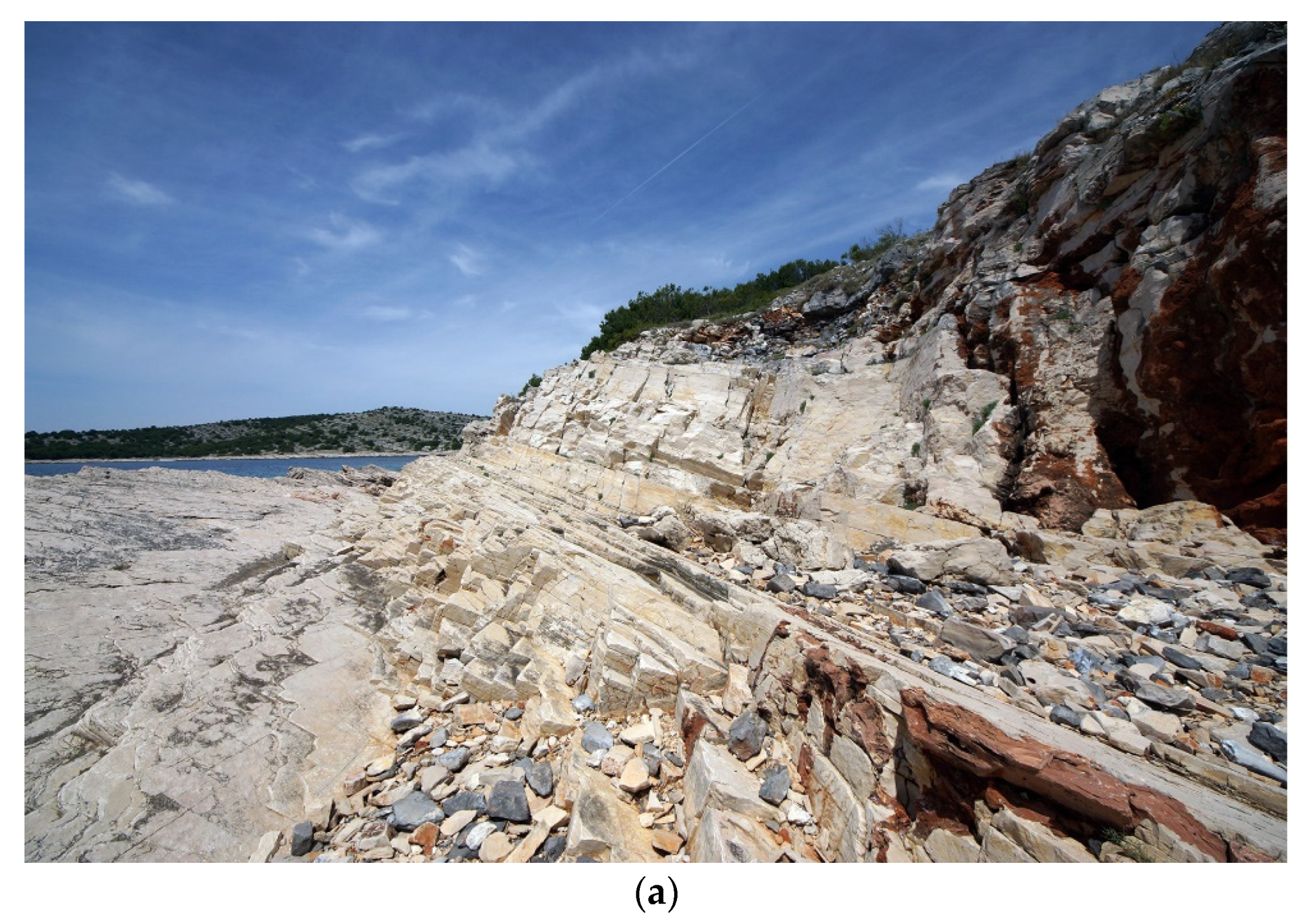
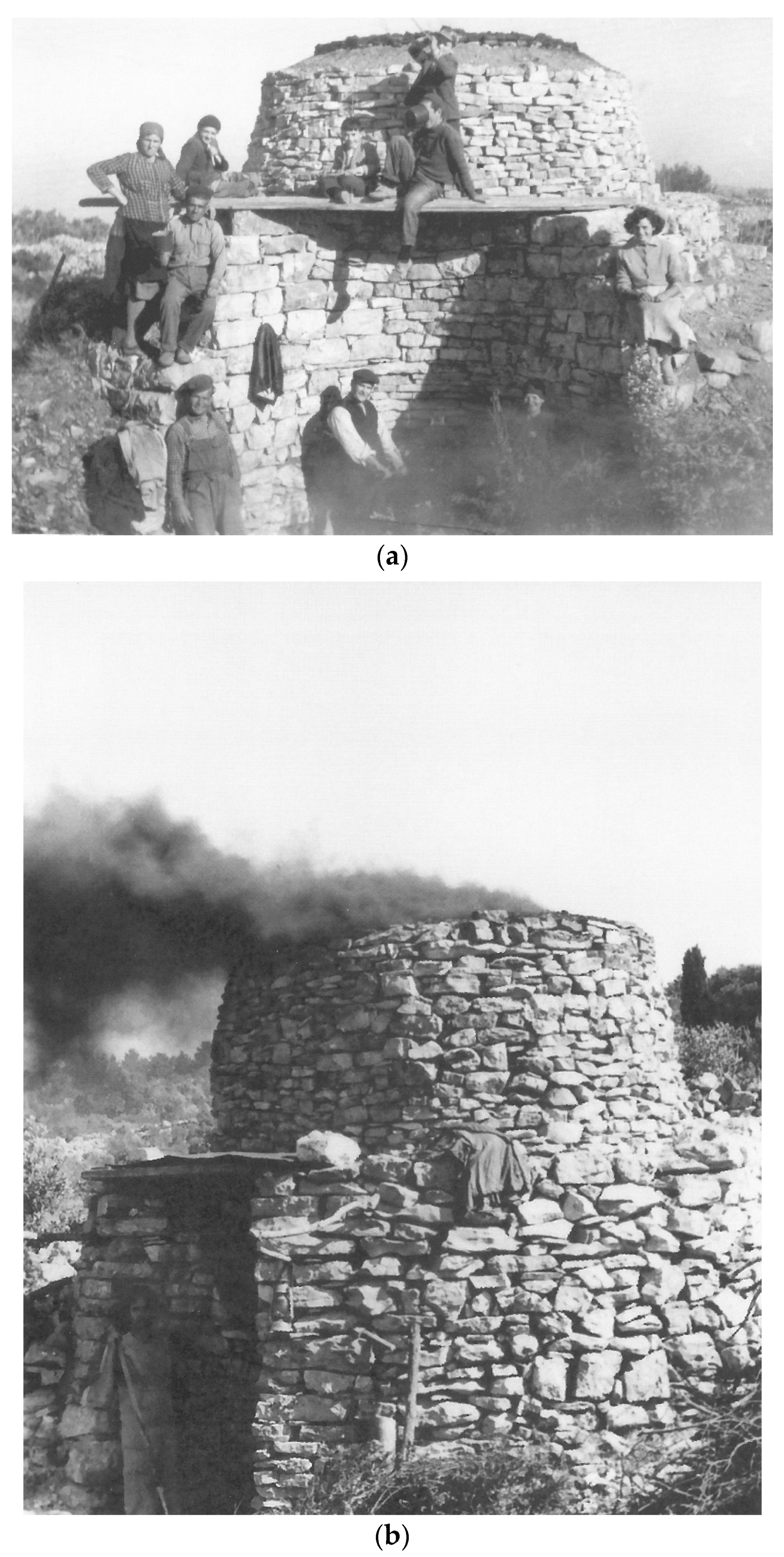
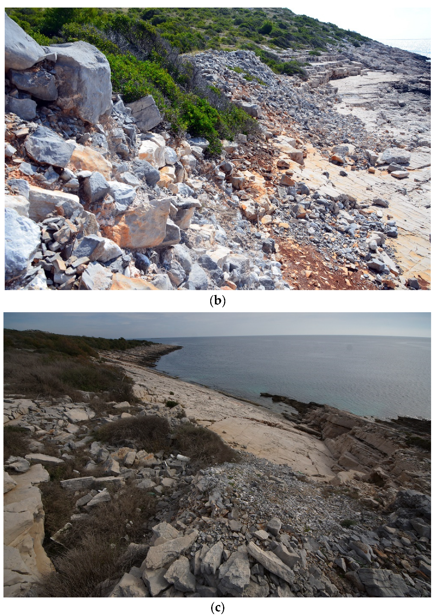
4.1. Locational Factors of Lime Production
4.2. The Oldest Archival Confirmation of Insular Lime Production
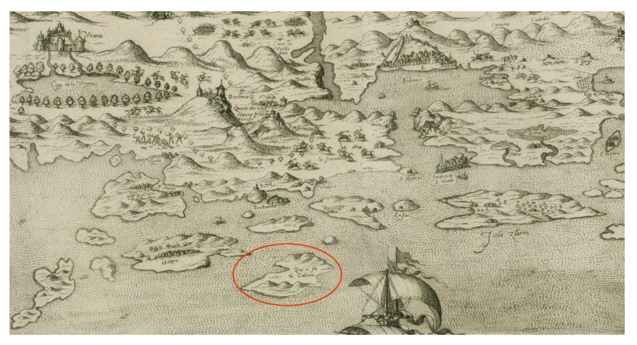
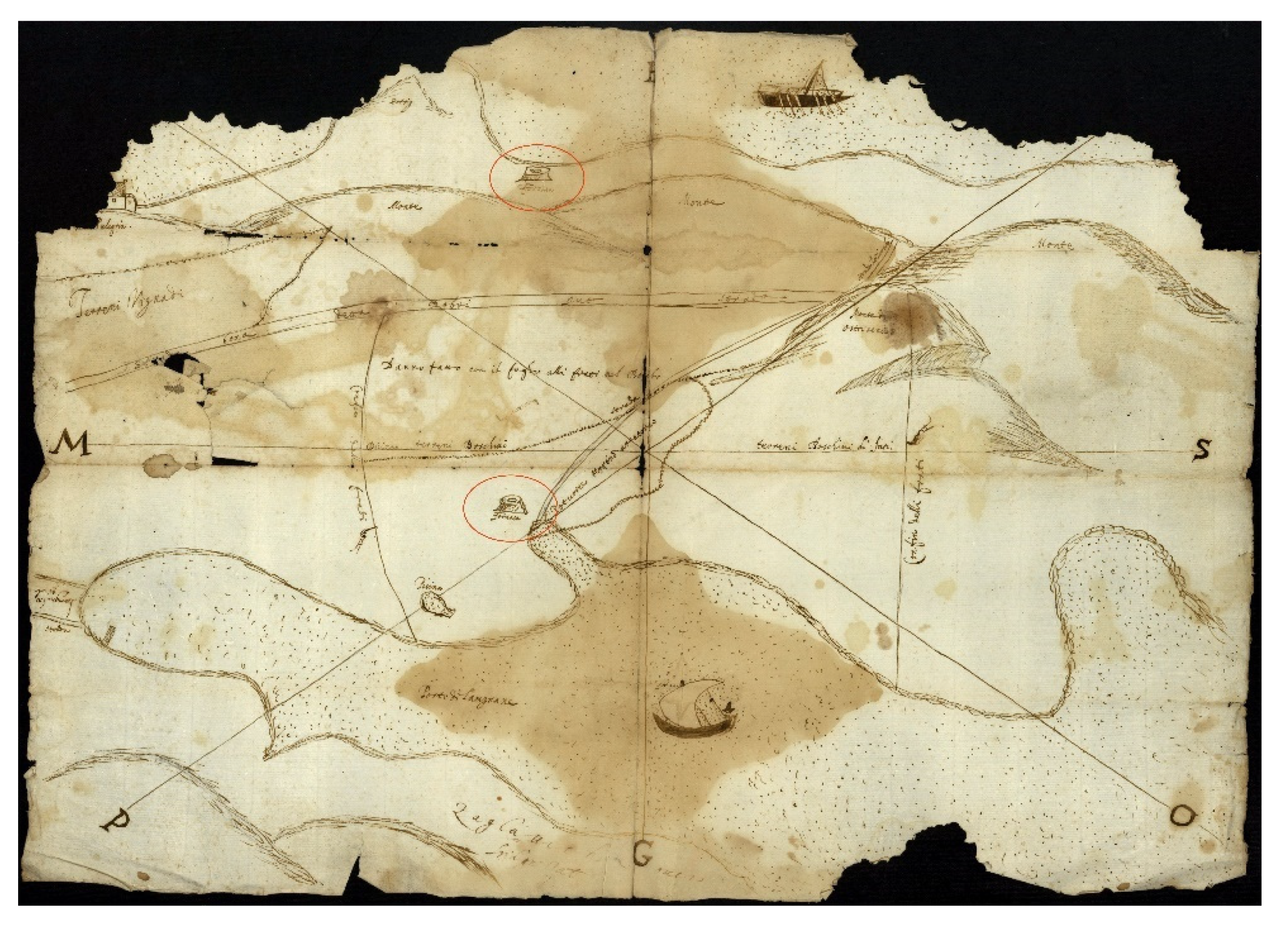
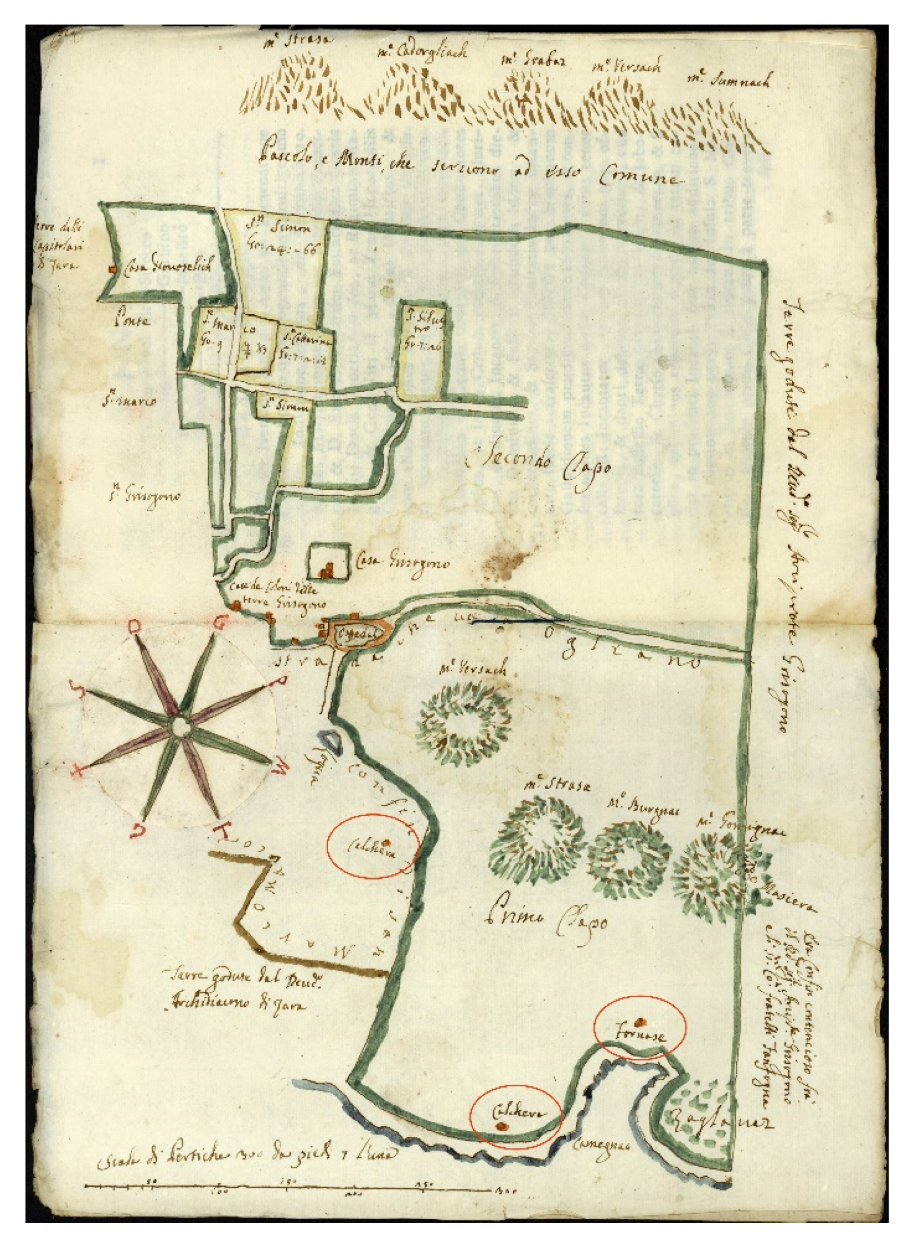
4.3. Cartographic Confirmations of Lime Production in the Northern Dalmatian Islands
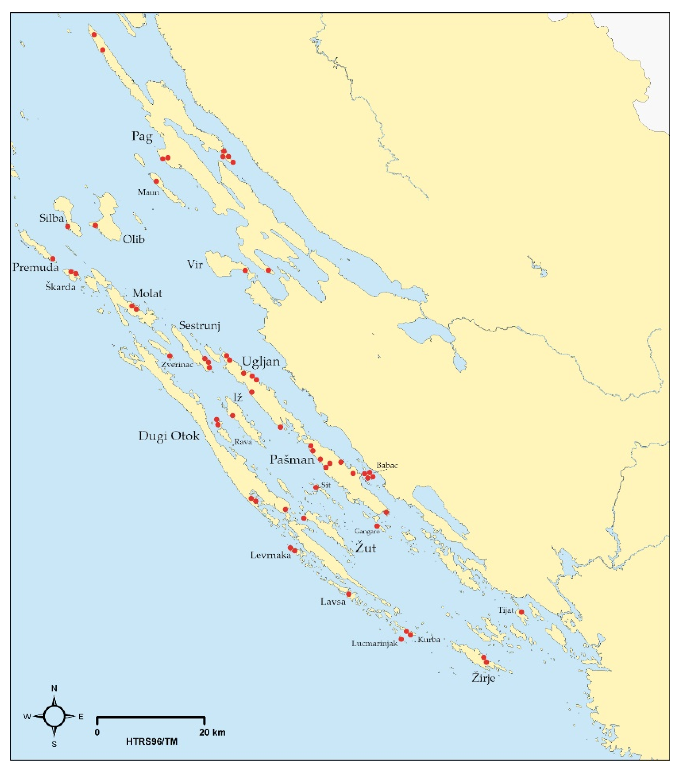
4.4. Lime Production’s Mark on the Linguistic Landscape
5. Conclusions
Author Contributions
Funding
Institutional Review Board Statement
Informed Consent Statement
Data Availability Statement
Acknowledgments
Conflicts of Interest
References
- Stošić, K. Sela Šibenskog Kotara; Tiskara Kačić: Šibenik, Croatia, 1941. [Google Scholar]
- Raukar, T.; Petricioli, I.; Švelec, F.; Peričić, Š. Prošlost Zadra III. Zadar pod Mletačkom Upravom; Narodni List and Filozofski Fakultet Zadar: Zadar, Croatia, 1987. [Google Scholar]
- Kolanović, J. Šibenik u Kasnome Srednjem Vijeku; Školska Knjiga: Zagreb, Croatia, 1995. [Google Scholar]
- Burri, E. Il paesaggio antropizzato nelle aree gessose. Aree Carsiche Gessose D Italia Mem. Ist. It. Spel 2003, 14 (Suppl. II), 47–54. [Google Scholar]
- Davico, M.A. Archeologia Della Produzione: Le Fornaci da Calce in Liguria, Cogoleto. Ph.D. Thesis di Laurea, Universita’ Degli Studi di Genova—Facoltà di Lettere e Filosofia, Genoa, Italy, 1994. [Google Scholar]
- Petrella, G. La produzione della calce: Stato degli studi e proposta di scheda di informatizzazione dei dati di un forno da calce. Archeol. Postmediev. Soc. Ambiente Prod. 2007, 11, 151–172. [Google Scholar]
- Vecchiattini, R. Unità produttive perfettamente organizzate: Le calcinare di Sestri Ponente-Genova. Unità produttive perfettamente organizzate: Le calcinare di Sestri Ponente-Genova. Archeol. Dell Archit. 1998, 3, 141–152. [Google Scholar]
- Carrera Díaz, G.; Olivi, A. Una de cal y una de arena: La producción de cal en el atlas del patrimonio inmaterial de Andalucía. In La Cal—Investigación, Patrimonio y Restauración; Sánchez, F.J.A., Flores Alés, V., Blasco-López, F.-J., Martín-del-Río, J.J., Eds.; Universidad de Sevilla, Secretariado de Publicaciones: Sevilla, Spain, 2014; pp. 149–166. [Google Scholar]
- Vázquez, J.S.; Baztán, P.O.; Tallón, A.S. Producción de cal a finales del mundo antiguo en el entorno sur de la Comunidad de Madrid. In Proceedings of the Actas Reunión de Arqueología Madrileña, Madrid, Spain, 25–26 May 2018; Sección de Arqueología del Colegio de Doctores y Licenciados en Filosofía y Letras y en Ciencias de Madrid: Madrid, Spain, 2018; pp. 78–90. [Google Scholar]
- Demarez, J.-D. La Production de Chaux en Ajoie (Jura, Suisse) de L’époque Romaine au XIXe Siècle: Recherches D’archéologie et D’histoire; Demarez, J.-D., Ed.; Office de la Culture et Société Jurassienne D’émulation: Porrentruy, Switzerland, 2014. [Google Scholar]
- Demierre, B. Les fours à chaux en Grèce. J. Rom. Archaeol. 2002, 15, 282–296. [Google Scholar] [CrossRef]
- Besombes-Hanry, A. Les fours à chaux de Nespouls (Corrèze). Aquitania 2007, 23, 207–231. [Google Scholar]
- Vaschalde, C. Les fours à chaux du Midi méditerranéen de la France, objets de nouvelles méthodes en archéologie médiévale. Debates Arqueol. Mediev. 2012, 2, 129–154. [Google Scholar]
- Jackson, D.A.; Biek, L.; Dix, B.F. A Roman lime kiln at Weekley, Northants. Britannia 1973, 4, 128–140. [Google Scholar] [CrossRef]
- Oates, J.A. Lime and Limestone: Chemistry and Technology, Production and Uses; Wiley-VCH: Weinheim, Germany, 2008. [Google Scholar]
- Dowling, A.; O’Dwyer, J.; Adley, C.C. Lime in the limelight. J. Clean. Prod. 2015, 92, 13–22. [Google Scholar] [CrossRef]
- Sarabia, J.; Galeazzi, G.; Busnardo, A. I paesaggi dell’incolto. In Drena: Insediamenti e Paesaggi Dai Longobardi ai Nostri Giorni; Brogiolo, G.P., Sarabia, J., Eds.; Museo Alto Garda: Trento, Italy; Società Archeologica: Mantova, Italy, 2016; pp. 145–171. [Google Scholar]
- Steffen, W.; Grinevald, J.; Crutzen, P.; McNeill, J. The Anthropocene: Conceptual and historical perspectives. Philos. Trans. R. Soc. A Math. Phys. Eng. Sci. 2011, 369, 842–867. [Google Scholar] [CrossRef]
- Davis, R. Inventing the present: Historical roots of the Anthropocene. Earth Sci. Hist. 2011, 30, 63–84. [Google Scholar]
- Ruddiman, W.F. The anthropocene. Annu. Rev. Earth Planet. Sci. 2013, 41, 45–68. [Google Scholar] [CrossRef]
- Lewis, S.L.; Maslin, M.A. Defining the anthropocene. Nature 2015, 519, 171–180. [Google Scholar] [CrossRef] [PubMed]
- Zalasiewicz, J.; Waters, C.; Williams, M. The anthropocene. In Geologic Time Scale 2020; Gradstein, F.M., Ogg, J.G., Schmitz, M.D., Ogg, G.M., Eds.; Elsevier: Amsterdam, The Netherlands; Oxford, UK; Cambridge, MA, USA, 2020; pp. 1257–1280. [Google Scholar]
- Zalasiewicz, J.; Williams, M.; Waters, C.N.; Barnosky, A.D.; Haff, P. The technofossil record of humans. Anthr. Rev. 2014, 1, 34–43. [Google Scholar] [CrossRef] [Green Version]
- Zlatunić, R. Istraživanje vapnenica na lokalitetu Dragonera sjever. In Dragonera—Dva Bisera, Monografije i Katalozi 19; Starac, A., Ed.; Arheološki Muzej Istre: Pula, Croatia, 2010; pp. 295–304. [Google Scholar]
- Čuka, A.; Faričić, J. The Croatian Islands: An Introduction. In The Notion of Near Islands—The Croatian Archipelago; Starc, N., Ed.; Rowman & Littlefield: Lanham, MD, USA; Boulder, CO, USA; New York, NY, USA; London, UK, 2020; pp. 55–88. [Google Scholar]
- Majcen, Ž.; Korolija, B. Tumač za List Zadar. Osnovna Geološka Karta 1:100,000; Institut za Geološka Istraživanja Zagreb: Zagreb, Croatia; Savezni Geološki Zavod: Beograd, Serbia (Yugoslavia), 1973. [Google Scholar]
- Mamužić, P. Tumač za List Šibenik. Osnovna Geološka Karta 1:100,000; Institut za Geološka Istraživanja Zagreb: Zagreb, Croatia; Savezni Geološki Zavod: Beograd, Serbia (Yugoslavia), 1975. [Google Scholar]
- Velić, I.; Vlahović, I. Vapnenci i dolomiti (donja kreda—K1). In Tumač Geološke Karte Republike Hrvatske 1:300,000; Velić, I., Vlahović, I., Eds.; Hrvatski Geološki Institut: Zagreb, Croatia, 2009; pp. 63–65. [Google Scholar]
- Fuček, L. Rudistni vapnenci (cenoman-mastriht—K21–6). In Tumač Geološke Karte Republike Hrvatske 1:300,000; Velić, I., Vlahović, I., Eds.; Hrvatski Geološki Institut: Zagreb, Croatia, 2009; pp. 66–69. [Google Scholar]
- Vlahović, I.; Velić, I. Liburnijske naslage, foraminiferski vapnenci i prijelazne naslage (gornji paleocen, donji i srednji eocen—Pc, E1,2) . In Tumač Geološke Karte Republike Hrvatske 1:300,000; Velić, I., Vlahović, I., Eds.; Hrvatski Geološki Institut: Zagreb, Croatia, 2009; pp. 76–77. [Google Scholar]
- Gams, I.; Gabrovec, M. Land use and human impact in the Dinaric karst. Int. J. Speleol. 1999, 28, 55–70. [Google Scholar] [CrossRef]
- Aničić, B.; Perica, P. Structural features of cultural landscape in the karst area (landscape in transition). Acta Carsologica 2003, 32, 173–188. [Google Scholar] [CrossRef]
- Cernatič-Gregorič, A.; Zega, M. The impact of human activities on dolines (sinkholes): Typical geomorphologic features on Karst (Slovenia) and possibilities of their preservation. Geogr. Pannonica 2010, 14, 109–117. [Google Scholar] [CrossRef] [Green Version]
- Kovačič, G.; Nataša Ravbar, N. Analysis of human induced changes in a karst landscape—The filling of dolines in the Kras plateau, Slovenia. Sci. Total Environ. 2013, 447, 143–151. [Google Scholar] [CrossRef] [PubMed]
- Cernatič Gregorič, A. Typical Doline and Surface Landforms of Kras (Slovenia): Karst Landscape Features and Possibilities for Their Conservation. Geoheritage 2021, 13, 1–9. [Google Scholar]
- Magaš, D.; Filipi, A.R. Otok Sestrunj u Zadarskom Arhipelagu; Vlastita Naklada: Zadar, Croatia, 1983. [Google Scholar]
- Parica, M. Nekoliko primjera lučkih instalacija antičkih kamenoloma na dalmatinskim otocima. Histria Antiq. 2012, 21, 345–354. [Google Scholar]
- Magaš, D. Zemljopisno-povijesna obilježja Dugog otoka. In Dugi Otok; Batović, Š., Ed.; Matica Hrvatska Zadar: Zadar, Croatia, 1997; pp. 11–44. [Google Scholar]
- Filipi, A.R. Otok Lavdara—Prilog povijesno-geografskim istraživanjima zadarskih otoka. Geoadria 2001, 6, 113–152. [Google Scholar] [CrossRef]
- Filipi, A.R. Povijesno-geografska obilježja Žutsko-sitske otočne skupine. Geoadria 2003, 8, 87–130. [Google Scholar]
- Kulušić, S. Tipska naselja gradnje “u suho” na kršu Hrvatskog primorja (na primjeru Kornatskih otoka). Hrvat. Geogr. Glas. 1999, 61, 53–83. [Google Scholar]
- Suić, M. Pag; Općina Pag: Zadar, Croatia, 1953. [Google Scholar]
- Marković, S. Hrvatske Mineralne Sirovine; Institut za Geološka Istraživanja—Zavod za Geologiju: Zagreb, Croatia, 2002. [Google Scholar]
- Faričić, J. Geografija Sjevernodalmatinskih Otoka; Školska Knjiga: Zagreb, Croatia, 2012. [Google Scholar]
- Savezni Zavod za Statistiku. Popis Stanovništva i Stanova 1971, Stanovi—Veličina, Svojina, Domaćinstva i Lica, Knjiga II; Savezni Zavod za Statistiku: Beograd, Yugoslavia, 1972. [Google Scholar]
- Savezni Zavod za Statistiku. Popis Stanovništva i Stanova 1971, Stanovi za Odmor i Rekreaciju, Knjiga VI; Savezni Zavod za Statistiku: Beograd, Yugoslavia, 1973. [Google Scholar]
- Državni Zavod za Statistiku. Popis Stanovništva, Kućanstava i Stanova 2001, Stanovi Prema Načinu Korištenja; Državni Zavod za Statistiku: Zagreb, Croatia, 2002. [Google Scholar]
- Magaš, D.; Faričić, J.; Surić, M. Geographical Bases of Evaluating the Coastline of Zadar Islands (Croatia). In Littoral 2002, Proceedings of the 6th International Symposium: The Changing Coast, Porto, Portugal, 22–26 September 2002; Gomes, F.V., Taveira Pinto, F., das Neves, L., Eds.; EUCC and EUROCOAST: Porto, Portugal, 2002; Volume 3, pp. 139–143. [Google Scholar]
- Blagaić, A.; Burica, M. Japjeničarstvo (vapnarstvo) na otoku Šolti. In Otok Šolta; Mihovilović, M.A., Ed.; Vlastita Naklada: Zagreb, Croatia, 1990; pp. 174–178. [Google Scholar]
- Herkov, Z. Prinosi za upoznavanje naših starih mjera za dužinu i površinu-nastavak. Zb. Odsjeka Za Povij. Znan. Zavoda Povij. Društvene Znan. Hrvat. Akad. Znan. Umjet. 1977, 8, 143–215. [Google Scholar]
- Šule, D. Svu Smo Robu Izgorili—Šolta i Šoltani na Starim Letratima; Općina Šolta: Grohote, Croatia, 2006. [Google Scholar]
- Filipi, A.R. Kretanje broja stanovništva zadarskog otočja I. Rad. Inst. JAZU Zadru 1959, 4, 279–318. [Google Scholar]
- Filipi, A.R. Kretanje broja stanovništva zadarskog otočja II. Rad. Inst. JAZU Zadru 1960, 6, 137–178. [Google Scholar]
- Jelić, R. Stanovništvo zadarskih otoka 1608. Godine. In Zadarsko Otočje; Uranija, V., Ed.; Narodni Muzej Zadar: Zadar, Croatia, 1974; pp. 147–205. [Google Scholar]
- Magaš, D. Vir—Prilog geografskim istraživanjima u zadarskoj regiji. Rad. Cent. JAZU Zadru 1977, 24, 5–51. [Google Scholar]
- Lago, V. Memorie Sulla Dalmazia; Stab. Naz. di G. Grimaldo: Venezia, Italia, 1869. [Google Scholar]
- Novak, G. Mletačka Uputstva i Izvještaji (Commissiones et Relationes Venetae), IV: Od 1572–1590, Monumenta Spectantia Historiam Slavorum Meridionalium, 47; JAZU: Zagreb, Croatia, 1964. [Google Scholar]
- Novak, G. Mletačka Uputstva i Izvještaji (Commissiones et Relationes Venetae), V: Od 1591–1600, Monumenta Spectantia Historiam Slavorum Meridionalium, 48; JAZU: Zagreb, Croatia, 1966. [Google Scholar]
- HR-DAZD-88, Vlada za Dalmaciju, Prospetto Generale Della Popolazione, del Bestiame, e de Mezzi di Trasporto di Tutta la Provincia Della Dalmazia per l’ Anno Solare 1830, No. VIII/9; Državni Arhiv u Zadru: Zadar, Croatia, 1831.
- Korenčić, M. Naselja i Stanovništvo SR Hrvatske 1857–1971; Jugoslavenska Akademije Znanosti i Umjetnosti: Zagreb, Croatia, 1979. [Google Scholar]
- Kraljević, R. Vinogradarski Slom i Demografski Rasap Južne Hrvatske u Osvit 20. Stoljeća; Književni Krug: Split, Croatia, 1994. [Google Scholar]
- Čuka, A.; Mirošević, L.; Faričić, J.; Graovac Matassi, V. Phylloxera revisited: The spread of grapevine disease in Dalmatia and its influence on socio-economic development and agricultural landscape. Ann. Anal. Istrske Mediter. Studije Ser. Hist. Sociol. 2017, 27, 101–118. [Google Scholar]
- Carska i Kraljevska Dvorska i Državna Štamparija. Općinski Rječnik za Kraljevine i Zemlje Zastupane u Carevinskom Vijeću, XIV: Dalmacija; Carska i Kraljevska Dvorska i Državna Štamparija: Beč, Austria, 1908. [Google Scholar]
- Juran, K. Kornati od 14–19. Stoljeća. In Toponimija Kornatskog Otočja; Skračić, V., Ed.; Sveučilište u Zadru: Zadar, Croatia, 2013; pp. 99–157. [Google Scholar]
- Juran, K. Povijesna toponimija šibenskog otočja prema spisima šibenskih bilježnika od 15–17. Stoljeća. In Toponimija Šibenskog Otočja; Skračić, V., Ed.; Sveučilište u Zadru: Zadar, Croatia, 2016; pp. 235–246. [Google Scholar]
- HR-DAŠI-263: Šibenski Bilježnici, Box 3/I, Vol. g, 33v; Državni Arhiv u Šibeniku: Šibenik, Croatia, 1421.
- HR-DAŠI-263: Šibenski Bilježnici, Box 29/III, Vol. a, 104r; Državni Arhiv u Šibeniku: Šibenik, Croatia, 1539.
- HR-DAZD-31: Bilježnici Zadra, Matheus Sonzonius (1492–1530), Vol. III, No. III/E, 18. 6. 1520; Državni Arhiv u Zadru: Zadar, Croatia, 1520.
- HR-DAZD-338: Dominikanski Samostan sv. Dominika, Box 16, No. 733; Državni Arhiv u Zadru: Zadar, Croatia, 1650.
- Peričić, Š. Prilog poznavanju gospodarskog života na otoku Pašmanu u 18. stoljeću. In Pašmanski Zbornik—Otok Pašman Kroz Vjekove i Danas; Ćosić, V., Ed.; Filozofski Fakultet u Zadru: Zadar, Croatia, 1987; pp. 183–194. [Google Scholar]
- HR-DAZD-1: Generalni Providuri za Dalmaciju i Albaniju, Box 22, Andrea Corner (1660–1662.), Book II, 240r; Državni Arhiv u Zadru: Zadar, Croatia, 1661.
- HR-DAZD-1: Generalni Providuri za Dalmaciju i Albaniju, Box 70, Giustin da Riva (1705–1708.), Book II, 6v-7r; Državni Arhiv u Zadru: Zadar, Croatia, 1705.
- HR-DAZD-1: Generalni Providuri za Dalmaciju i Albaniju, Box 73, Vincenzo Vendramin (1708–1711.), Book III, 418v, 440r, 443r-v, 445v-446r, 447r, 449r, 451v, 459v-460r, 463r-v; Državni Arhiv u Zadru: Zadar, Croatia, 1711.
- GE DD-655 (60RES); Bibliothèque Nationale de France: Paris, France, 1571.
- HR-DAZD-338: Dominikanski Samostan sv. Dominika, Box 21, No. 898; Državni Arhiv u Zadru: Zadar, Croatia, 1736.
- HR-DAZD-338: Dominikanski Samostan sv. Dominika, Box 22, No. 902; Državni Arhiv u Zadru: Zadar, Croatia, 1736.
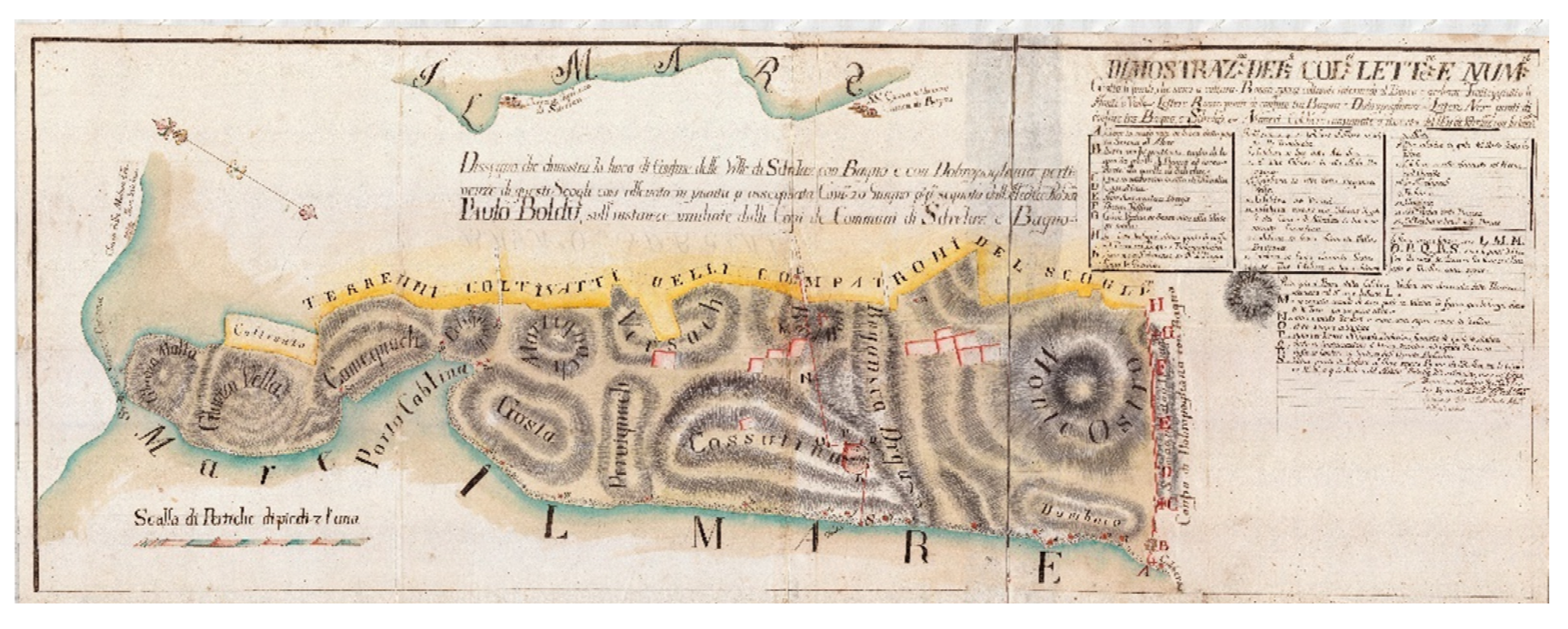
- HR-DAZD-6: Mletački katastar. Mape Grimani, Lorenzo Licini Rubčić, Dissegno che Demonstra la Linea di Confine Delle Ville di Sdrelaz con Bagno e con Dobropogliana; No. 401; Državni Arhiv u Zadru: Zadar, Croatia, 1782.
- Skračić, V. Odraz ljudskog rada u obalnoj toponimiji sjevernodalmatinskih otoka. Rad. Filoz. Fak. Zadru 26 Razdio Filoloških Znan. 1987, 16, 93–111. [Google Scholar] [CrossRef]
- Skračić, V. Toponimija Vanjskog i Srednjeg Niza Zadarskih Otoka; Matica Hrvatska—Zadar and Književni Krug: Split, Croatia, 1996. [Google Scholar]
- Skračić, V. Toponimija Kornatskog Otočja; Skračić, V., Ed.; Sveučilište u Zadru: Zadar, Croatia, 2013. [Google Scholar]
- Skračić, V. Toponimija Otoka Murtera; Skračić, V., Ed.; Sveučilište u Zadru: Zadar, Croatia, 2010. [Google Scholar]
- Skračić, V. Toponimija Otoka Paga; Skračić, V., Ed.; Sveučilište u Zadru: Zadar, Croatia, 2011. [Google Scholar]
- Skračić, V. Toponimija Otoka Pašmana; Skračić, V., Ed.; Sveučilište u Zadru: Zadar, Croatia, 2006. [Google Scholar]
- Skračić, V. Toponimija Otoka Ugljana; Skračić, V., Ed.; Sveučilište u Zadru: Zadar, Croatia, 2007. [Google Scholar]
- Skračić, V. Toponimija Otoka Vrgade; Skračić, V., Ed.; Sveučilište u Zadru: Zadar, Croatia, 2009. [Google Scholar]
- Skračić, V. Toponimija Šibenskog Otočja; Skračić, V., Ed.; Sveučilište u Zadru: Zadar, Croatia, 2016. [Google Scholar]
- Skračić, V.; Šprljan, N. Toponimija otoka Vira. In Otok Vir; Magaš, D., Ed.; Sveučilište u Zadru and Općina Vir: Zadar, Croatia, 2016; pp. 475–512. [Google Scholar]


| Year | 1857 | 1869 | 1880 | 1890 | 1900 | 1910 | 1921 | 1931 | 1948 |
|---|---|---|---|---|---|---|---|---|---|
| Population | 27,914 | 30,211 | 33,464 | 37,045 | 42,024 | 45,124 | 49,661 | 48,400 | 48,421 |
| Island | Toponyms |
|---|---|
| Premuda | Japnenica |
| Silba | Punta Japlenica |
| Olib | Japlenica |
| Pag | Furnaža (three localities with this name), Japnenica (four localities with this name), Punta Frnaže, Klačina |
| Maun | Japnenica |
| Vir | Japnenica |
| Škarda | Japlenica, Belejska Japlenica |
| Molat | Japlenica, Japnenica |
| Zverinac | Pod Japlenicu |
| Sestrunj | Japleniško, Malo Japleniško, Punta Japleniškoga |
| Ugljan | Japlenica (two localities with this name), Mala Japlenica, Vela Japlenica, Zmorašnja Frnaža, Južnja Frnaža, Japleniško |
| Pašman | Japlenica (four localities with this name), Japlenice (two localities with this name), Pod Japlenicu, Put Japlenice |
| Babac | Japlenica na Prosiki, Japlenica u Barinon, Japlenica u Burića, Japlenica u Borin |
| Gangaro | Japnjenica |
| Iž | Japleniško |
| Rava | Japnenica, Pod Japnenicu |
| Dugi otok | Japnenica (three localities with this name) |
| Sit | Japjenica |
| Žut | Japjenica |
| Levrnaka | Japjenice, Pod Japjenice |
| Lavsa | Japjenica |
| Lucmarinjak | Japjenica |
| Kurba | Japjenica, Pod Japjenicu |
| Tijat | Japjenica |
| Žirje | Japljenišće, Punta Japlenišća |
Publisher’s Note: MDPI stays neutral with regard to jurisdictional claims in published maps and institutional affiliations. |
© 2021 by the authors. Licensee MDPI, Basel, Switzerland. This article is an open access article distributed under the terms and conditions of the Creative Commons Attribution (CC BY) license (https://creativecommons.org/licenses/by/4.0/).
Share and Cite
Faričić, J.; Juran, K. Human Footprints in the Karst Landscape: The Influence of Lime Production on the Landscape of the Northern Dalmatian Islands (Croatia). Geosciences 2021, 11, 303. https://doi.org/10.3390/geosciences11080303
Faričić J, Juran K. Human Footprints in the Karst Landscape: The Influence of Lime Production on the Landscape of the Northern Dalmatian Islands (Croatia). Geosciences. 2021; 11(8):303. https://doi.org/10.3390/geosciences11080303
Chicago/Turabian StyleFaričić, Josip, and Kristijan Juran. 2021. "Human Footprints in the Karst Landscape: The Influence of Lime Production on the Landscape of the Northern Dalmatian Islands (Croatia)" Geosciences 11, no. 8: 303. https://doi.org/10.3390/geosciences11080303
APA StyleFaričić, J., & Juran, K. (2021). Human Footprints in the Karst Landscape: The Influence of Lime Production on the Landscape of the Northern Dalmatian Islands (Croatia). Geosciences, 11(8), 303. https://doi.org/10.3390/geosciences11080303