
Plio-Pleistocene Landscape Evolution of the Turano River Basin (Central Apennines, Italy): Insights from Continental Deposits’ Analysis and Drainage Network Development

 , ,
, ,  ,
, 
Abstract
1. Introduction
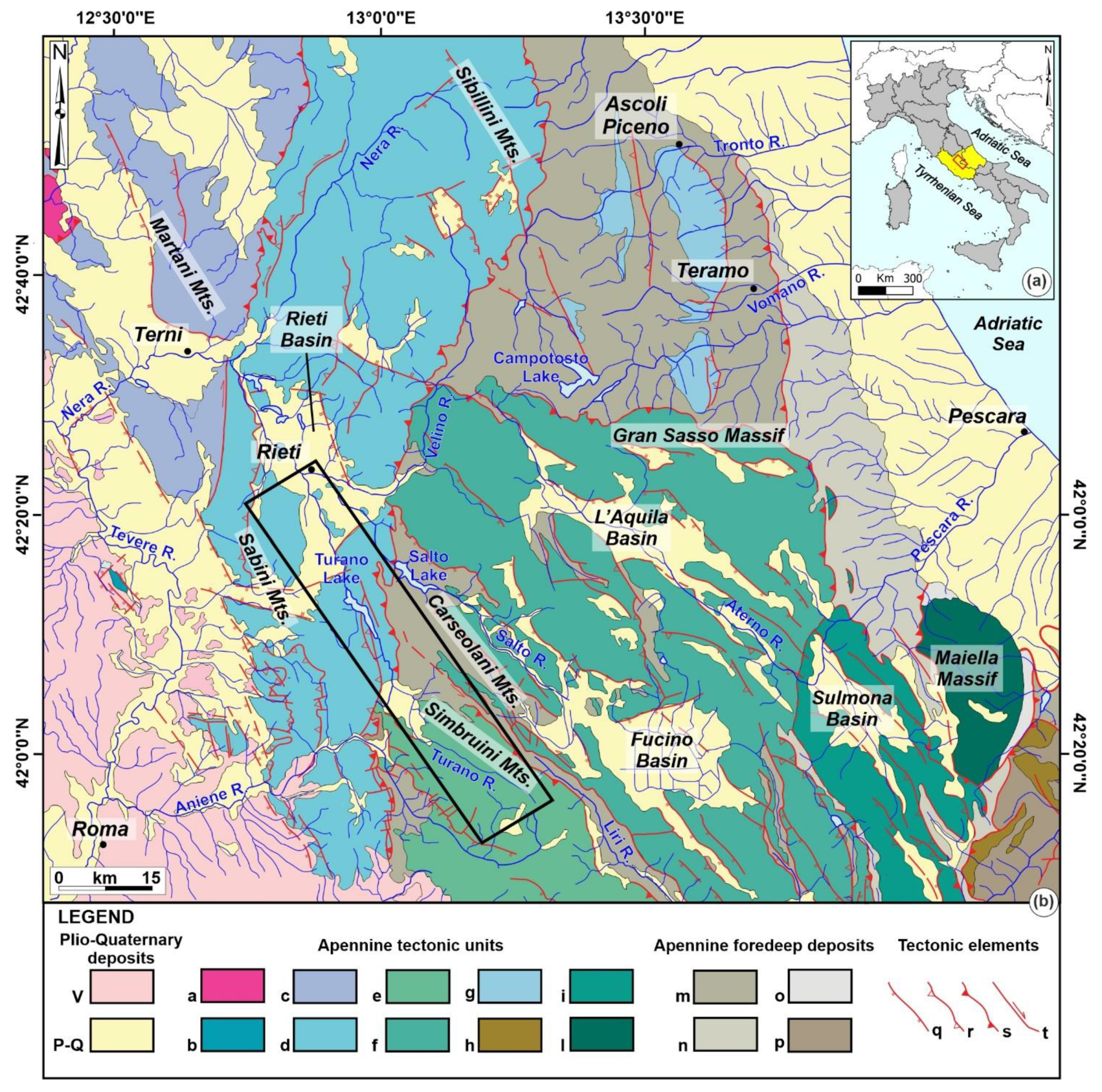
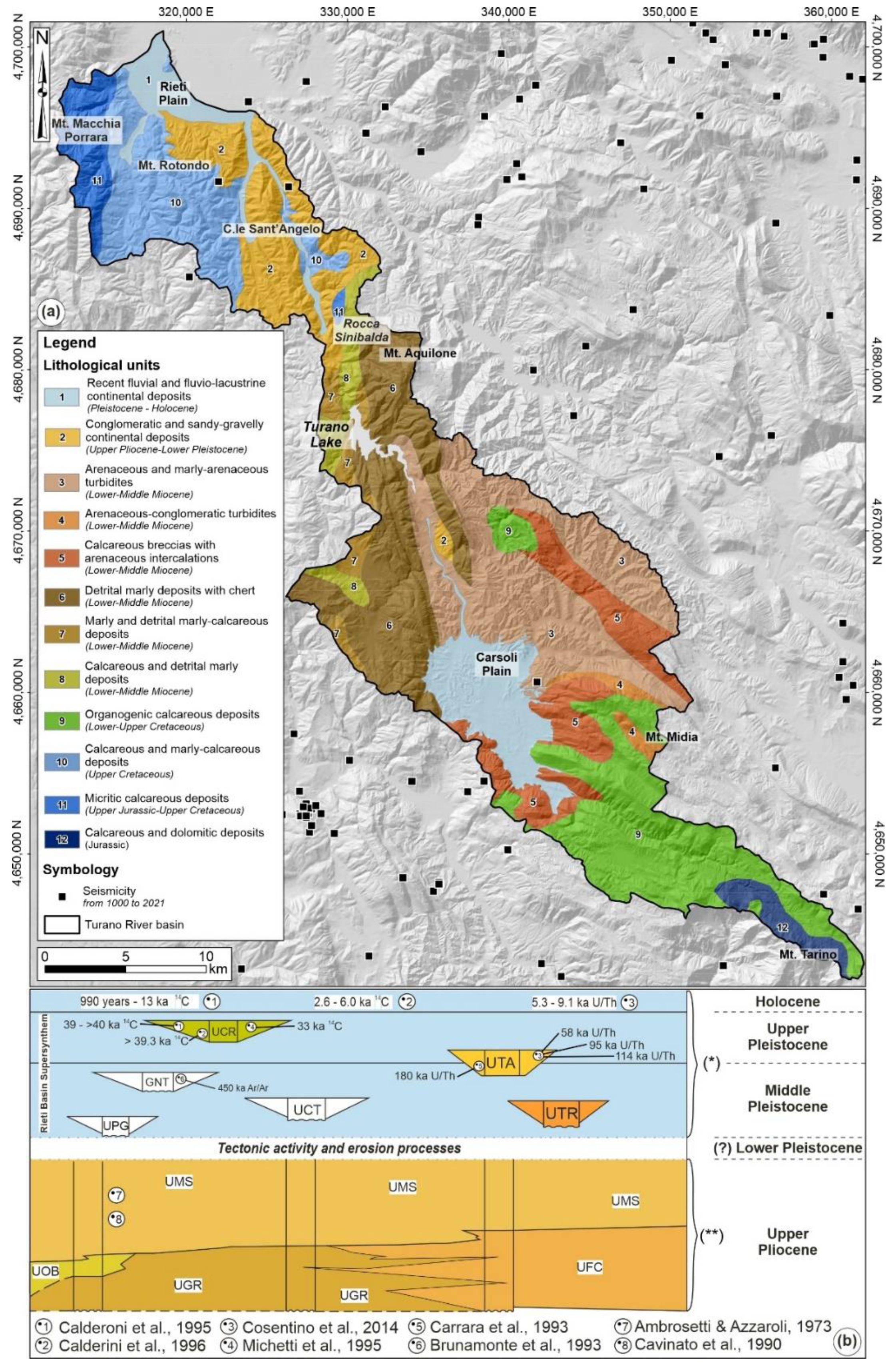
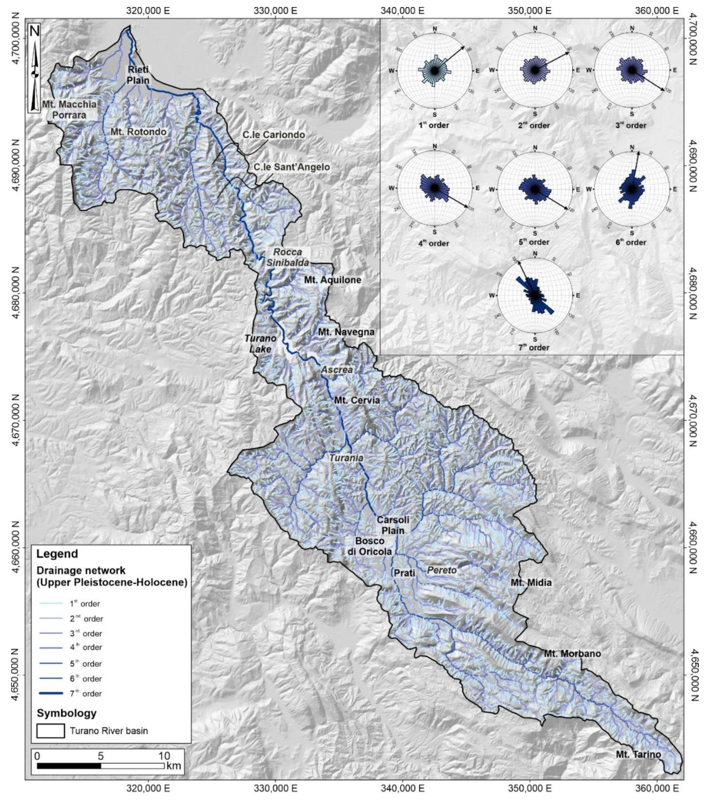
2. Study Area
3. Materials and Methods
4. Results
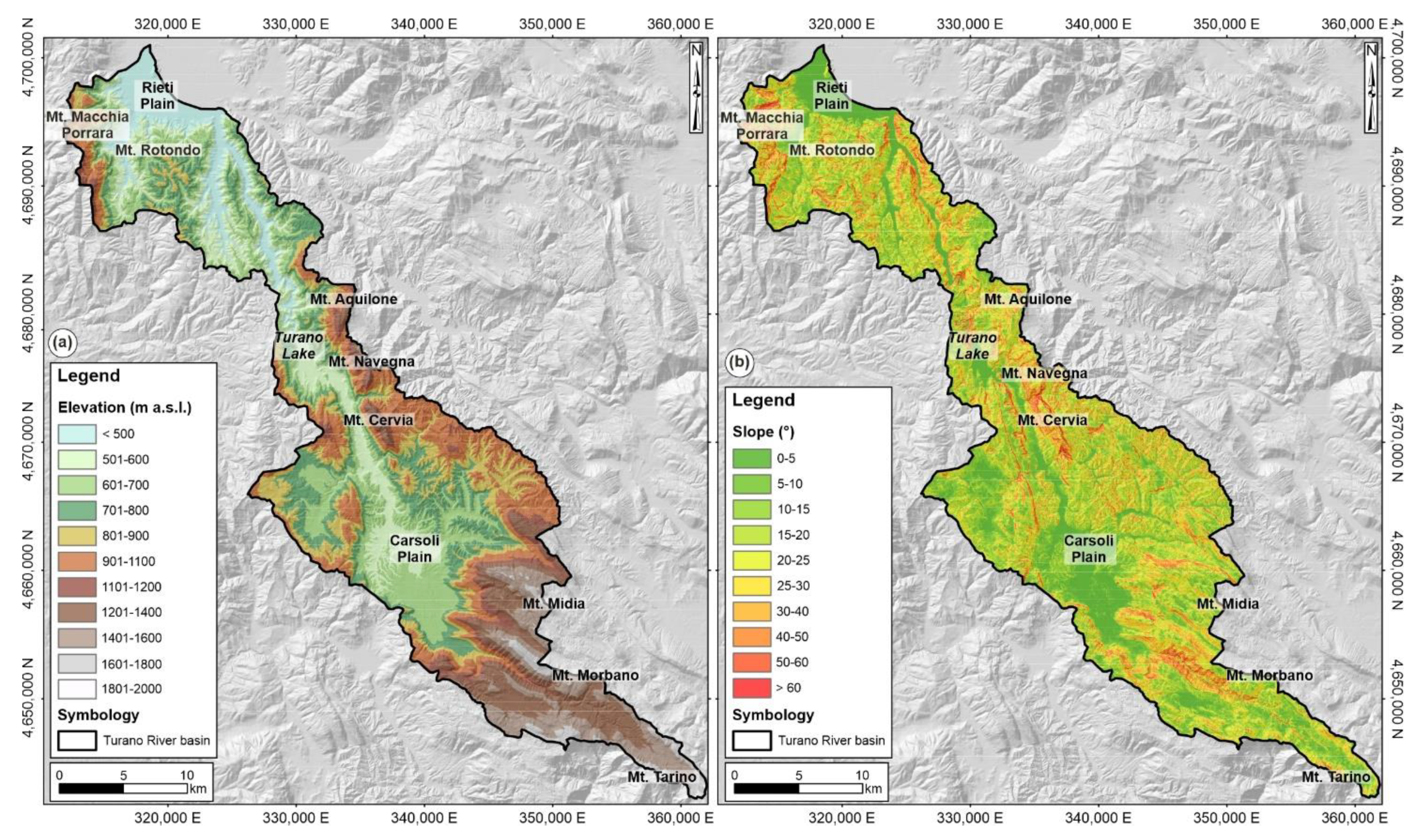
4.1. Morphometric Analysis
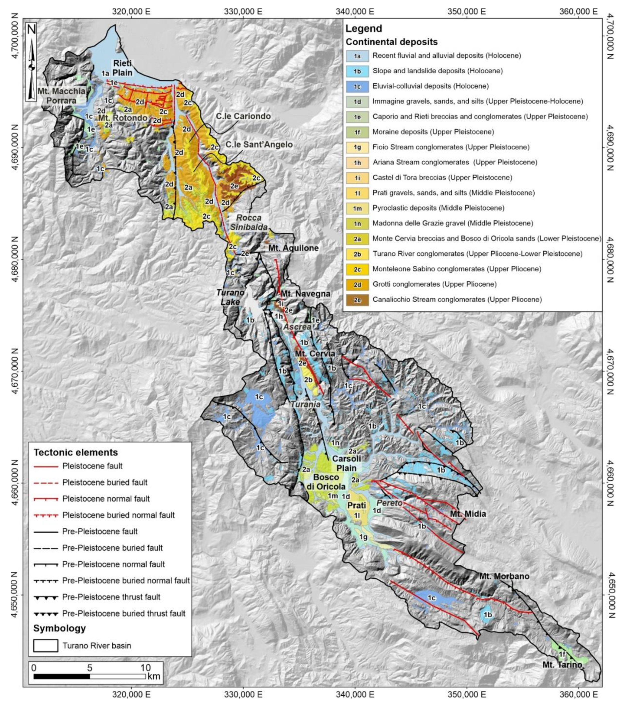
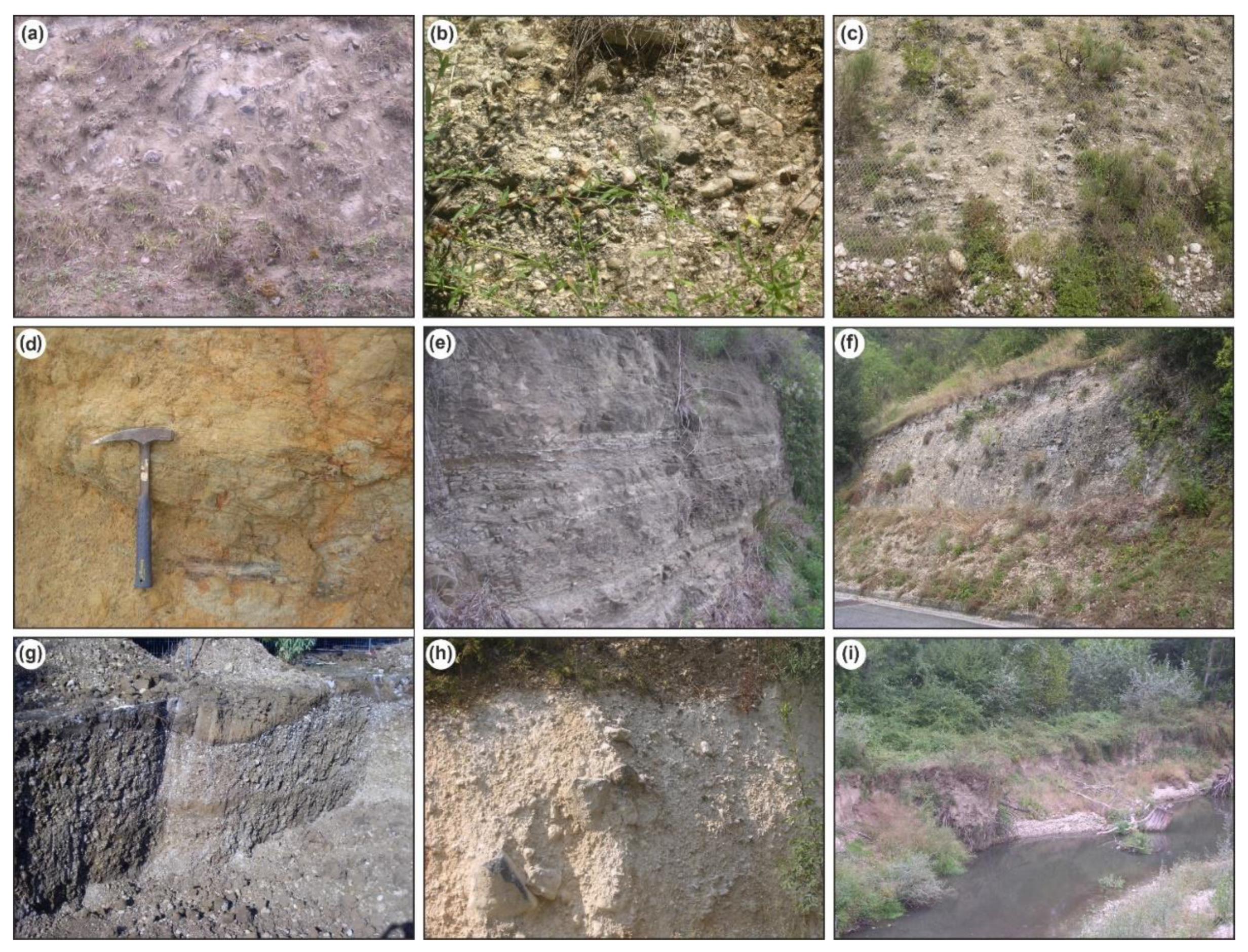
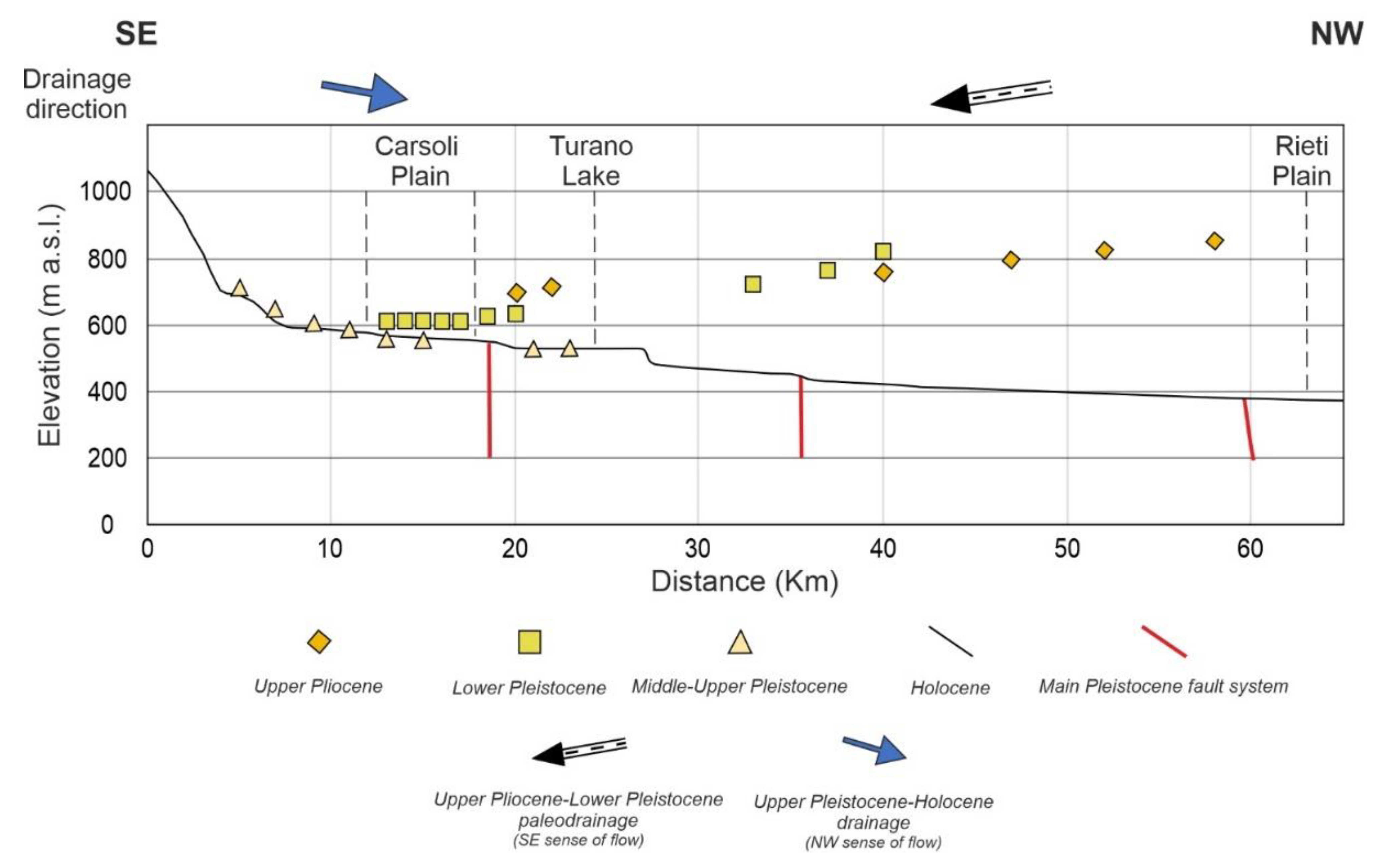
4.2. Continental Deposits
- Upper Pliocene-Lower Pleistocene deposits (units from 2e to 2a);
- Middle Pleistocene deposits (units from 1n to 1l);
- Upper Pleistocene-Holocene deposits (units from 1i to 1a).
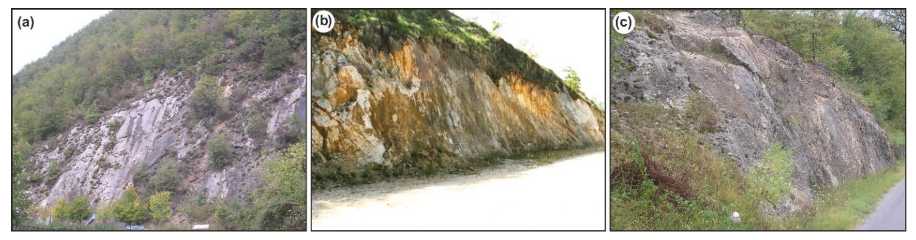
4.3. Tectonic Elements
4.4. Drainage System Development
5. Discussion
6. Conclusions
Author Contributions
Funding
Data Availability Statement
Acknowledgments
Conflicts of Interest
References
- Huntington, K.W.; Klepeis, K.A. Challenges and Opportunities for Research in Tectonics: Understanding Deformation and the Processes that Link Earth Systems, from Geologic Time to Human Time; University of Washington: Seattle, WA, USA, 2018. [Google Scholar] [CrossRef]
- Mancini, M.; Cavinato, G.P. The Middle Valley of the Tiber River, Central Italy: Plio-Pleistocene Fluvial and Coastal Sedimentation, Extensional Tectonics and Volcanism. In Fluvial Sedimentology VII; Blum, M.D., Marriot, S.B., Leclair, S.F., Eds.; International Association of Sedimentologists: Algiers, Algeria, 2005; pp. 373–396. ISBN 978-1-405-12651-9. [Google Scholar]
- D’Orefice, M.; Graciotti, R.; Capitanio, F.; Stoppa, F.; Rosatelli, G.; Barbieri, M. Il vulcanismo medio-pleistocenico dell’Appennino Laziale–Abruzzese: Dalle peculiarità scientifiche agli aspetti applicativi. Mem. Descr. Della Cart. Geol. D’Ital. 2006, LXXII, 7–67. [Google Scholar]
- D’Agostino, N.; Jackson, J.A.; Dramis, F.; Funiciello, R. Interactions between mantle upwelling, drainage evolution and active normal faulting: An example from the central Apennines (Italy). Geophys. J. Int. 2001, 147, 475–497. [Google Scholar] [CrossRef]
- Miccadei, E.; Piacentini, T.; Buccolini, M. Long-term geomorphological evolution in the Abruzzo area, Central Italy: Twenty years of research. Geol. Carpathica 2017, 68, 19–28. [Google Scholar] [CrossRef]
- Bartolini, C.; D’Agostino, N.; Dramis, A.F. Topography, exhumation, and drainage network evolution of the Apennines. Episodes 2003, 26, 212–216. [Google Scholar] [CrossRef] [PubMed]
- Piacentini, T.; Miccadei, E. The role of drainage systems and intermontane basins in the Quaternary landscape of the Central Apennines chain (Italy). Rend. Lincei 2014, 25, 139–150. [Google Scholar] [CrossRef]
- Vezzani, L.; Festa, A.; Ghisetti, F.C. Geology and tectonic evolution of the Central-Southern Apennines, Italy. In Special Paper of the Geological Society of America; Geological Society of America, Ed.; Geological Society of America: Boulder, CO, USA, 2010; p. 58. [Google Scholar]
- Cosentino, D.; Asti, R.; Nocentini, M.; Gliozzi, E.; Kotsakis, T.; Mattei, M.; Esu, D.; Spadi, M.; Tallini, M.; Cifelli, F.; et al. New insights into the onset and evolution of the central Apennine extensional intermontane basins based on the tectonically active L’Aquila Basin (central Italy). GSA Bull. 2017, 129, 1314–1336. [Google Scholar] [CrossRef]
- Miccadei, E.; Paron, P.; Piacentini, T. The SW escarpment of Montagna del Morrone (Abruzzi, Central Italy): Geomorphology of a fault-generated mountain front. Geogr. Fis. E Din. Quat. 2004, 27, 55–87. [Google Scholar]
- Ascione, A.; Cinque, A.; Miccadei, E.; Villani, F.; Berti, C. The Plio-Quaternary uplift of the Apennine chain: New data from the analysis of topography and river valleys in Central Italy. Geomorphology 2008, 102, 105–118. [Google Scholar] [CrossRef]
- Cowie, P.A.; Phillips, R.J.; Roberts, G.P.; McCaffrey, K.; Zijerveld, L.J.J.; Gregory, L.C.; Walker, J.F.; Wedmore, L.N.J.; Dunai, T.; Binnie, S.A.; et al. Orogen-scale uplift in the central Italian Apennines drives episodic behaviour of earthquake faults. Sci. Rep. 2017, 7, 44858. [Google Scholar] [CrossRef]
- Lucchi, M.R.; Calderoni, G.; Carrara, C.; Cipriani, N.; Esu, D.; Ferreli, L.; Girotti, O.; Gliozzi, E.; Lombardo, M.; Longinelli, A.; et al. Late Quaternary record of the Rieti basin, central Italy: Paleoenvironmental and paleoclimatic evolution. G. Geol. 2000, 62, 105–136. [Google Scholar]
- Borrelli, P.; Hoelzmann, P.; Knitter, D.; Schütt, B. Late Quaternary soil erosion and landscape development in the Apennine region (central Italy). Quat. Int. 2013, 312, 96–108. [Google Scholar] [CrossRef]
- Mazzanti, R.; Trevisan, L. Evoluzione della rete idrografica nell’Appennino centro-settentrionale. Geogr. Fis. Din. Quat. 1978, 1, 55–62. [Google Scholar]
- D’Alessandro, L.; Miccadei, E.; Piacentini, T. Morphostructural elements of central–eastern Abruzzi: Contributions to the study of the role of tectonics on the morphogenesis of the Apennine chain. Quat. Int. 2003, 101–102, 115–124. [Google Scholar] [CrossRef]
- Miccadei, E.; Piacentini, T. Two Tectonic Geomorphology Studies on the Landscape and Drainage Network of Chain and Piedmont Areas of the Abruzzi Region (Central Apennines, Italy). In New Frontiers in Tectonic Research—At the Midst of Plate Convergence; Uri Schattner: Rijeka, Croatia, 2011; pp. 173–214. [Google Scholar]
- Curzi, M.; Aldega, L.; Bernasconi, S.; Berra, F.; Billi, A.; Boschi, C.; Franchini, S.; Van Der Lelij, R.; Viola, G.; Carminati, E. Architecture and evolution of an extensionally-inverted thrust (Mt. Tancia Thrust, Central Apennines): Geological, structural, geochemical, and K–Ar geochronological constraints. J. Struct. Geol. 2020, 136, 104059. [Google Scholar] [CrossRef]
- Geurts, A.H.; Whittaker, A.C.; Gawthorpe, R.L.; Cowie, P.A. Transient landscape and stratigraphic responses to drainage integration in the actively extending central Italian Apennines. Geomorphology 2020, 353, 107013. [Google Scholar] [CrossRef]
- Morais, E.S.; Cremon, É.H.; Santos, M.L.; Rocha, P.C. Late Pleistocene-Holocene landscape evolution in the lower Peixe river, Brazil: A meandering river valley. J. S. Am. Earth Sci. 2020, 102, 102664. [Google Scholar] [CrossRef]
- Struth, L.; Garcia-Castellanos, D.; Viaplana-Muzas, M.; Vergés, J. Drainage network dynamics and knickpoint evolution in the Ebro and Duero basins: From endorheism to exorheism. Geomorphology 2019, 327, 554–571. [Google Scholar] [CrossRef]
- Pavano, F.; Pazzaglia, F.J.; Catalano, S. Knickpoints as geomorphic markers of active tectonics: A case study from northeastern Sicily (southern Italy). Lithosphere 2016, 8, 633–648. [Google Scholar] [CrossRef]
- Maroukian, H.; Gaki-Papanastassiou, K.; Karymbalis, E.; Vouvalidis, K.; Pavlopoulos, K.; Papanastassiou, D.; Albanakis, K. Morphotectonic control on drainage network evolution in the Perachora Peninsula, Greece. Geomorphology 2008, 102, 81–92. [Google Scholar] [CrossRef]
- Valente, E.; Buscher, J.T.; Jourdan, F.; Petrosino, P.; Reddy, S.M.; Tavani, S.; Corradetti, A.; Ascione, A. Constraining mountain front tectonic activity in extensional setting from geomorphology and Quaternary stratigraphy: A case study from the Matese ridge, southern Apennines. Quat. Sci. Rev. 2019, 219, 47–67. [Google Scholar] [CrossRef]
- Struth, L.; Giachetta, E.; Willett, S.D.; Owen, L.A.; Tesón, E. Quaternary drainage network reorganization in the Colombian Eastern Cordillera plateau. Earth Surf. Process. Landf. 2020, 45, 1789–1804. [Google Scholar] [CrossRef]
- Patacca, E.; Sartori, R.; Scandone, P. Tyrrhenian basin and Apenninic Arcs: Kinematic relations since Late Tortonian times. Mem. Soc. Geol. Ital. 1990, 45, 425–451. [Google Scholar]
- Parotto, M.; Cavinato, G.P.; Miccadei, E.; Tozzi, M. Line CROP 11: Central Apennines. CROP Atlas: Seismic reflection profiles of the Italian crust. Mem. Descr. Della Cart. Geol. D’Ital. 2003, LXII, 145–163. [Google Scholar]
- Bosi, C.; Galadini, F.; Giaccio, B.; Messina, P.; Sposato, A. Plio-Quaternary continental deposits in the Latium-Abruzzi Apennines: The correlation of geological events across different intermountain basins. Il Quat. 2003, 16, 55–76. [Google Scholar]
- Galadini, F.; Messina, P. Early–Middle Pleistocene eastward migration of the Abruzzi Apennine (central Italy) extensional domain. J. Geodyn. 2004, 37, 57–81. [Google Scholar] [CrossRef]
- Gori, S.; Falcucci, E.; Ladina, C.; Marzorati, S.; Galadini, F. Active faulting, 3-D geological architecture and Plio-Quaternary structural evolution of extensional basins in the central Apennine chain, Italy. Solid Earth 2017, 8, 319–337. [Google Scholar] [CrossRef]
- Michetti, A.M.; Brunamonte, F.; Serva, L.; Whitney, R.A. Seismic hazard assesment from paleoseismological evidence in the Rieti Region (Central Italy). In Perspectives in Paleoseismology; Serva, L., Slemmonds, D.B., Eds.; Peanut Butter Publishing: Seattle WA, USA, 1995; pp. 63–82. [Google Scholar]
- Cavinato, G.P.; Cosentino, D.; De Rita, D.; Funiciello, R.; Parotto, M. Tectonic-sedimentary evolution of intrapenninic basins and correlation with the volcano-tectonic activity in Central Italy. Mem. Descr. Della Cart. Geol. D’Ital. 1994, XLIX, 63–76. [Google Scholar]
- Scrocca, D.; Doglioni, C.; Innocenti, F. Contraints for an interpretation of the italian geodynamics: A review. Mem. Descr. Cart. Geol. D’Ital. 2003, LXII, 15–46. [Google Scholar]
- Mattei, M.; Conticelli, S.; Giordano, G. The Tyrrhenian margin geological setting: From the Apennine orogeny to the K-rich volcanism. Colli Albani Volcano 2018, 3, 7–27. [Google Scholar] [CrossRef]
- Fubelli, G.; Seta, M.D.; Amato, G. Drainage system adjustment in response to the opening of the Rieti intermontane basin (Central Italy): Geostatistical reconstruction of the PaleoFarfa River alluvial plain. Rend. Lincei 2014, 25, 167–176. [Google Scholar] [CrossRef]
- Geurts, A.H.; Cowie, P.A.; Duclaux, G.; Gawthorpe, R.L.; Huismans, R.S.; Pedersen, V.K.; Wedmore, L.N.J. Drainage integration and sediment dispersal in active continental rifts: A numerical modelling study of the central Italian Apennines. Basin Res. 2018, 30, 965–989. [Google Scholar] [CrossRef]
- Marino, M.; Menotti, R.M.; Miccadei, E.; Moretti, P.; Motteran, G.; Russo, L.; Scalise, A.R.; Serafini, R.; Spogli, G. The Turano Lake and the Big Dam. A geological tour along the Turano road between the regions of Lazio and Abruzzo. Mem. Descr. Della Cart. Geol. d’Ital. 2014, 102, 87–100. [Google Scholar]
- Mellini, F.; Petitta, M. Hydrogeological surveys to assess groundwater resoureces in the Middle Valley of Turano River (Central Italy). Ital. J. Eng. Geol. Environ. 2013, 2, 15–30. [Google Scholar]
- Borrelli, P.; Maerker, M.; Panagos, P.; Schütt, B. Modeling soil erosion and river sediment yield for an intermountain drainage basin of the Central Apennines, Italy. Catena 2014, 114, 45–58. [Google Scholar] [CrossRef]
- Borrelli, P.; Märker, M.; Schütt, B.; Maerker, M. Modelling Post-Tree-Harvesting Soil Erosion and Sediment Deposition Potential in the Turano River Basin (Italian Central Apennine). Land Degrad. Dev. 2013, 26, 356–366. [Google Scholar] [CrossRef]
- Cavinato, G.P. Recent tectonic evolution of the Quaternary deposits of the Rieti Basin (central Apennines, Italy): Southern part. Geol. Rom. 1993, 29, 411–434. [Google Scholar]
- Mancini, M.; Cavuoto, G.; Pandolfi, L.; Petronio, C.; Salari, L.; Sardella, R. Coupling basin infill history and mammal biochronology in a Pleistocene intramontane basin: The case of western L’Aquila Basin (central Apennines, Italy). Quat. Int. 2012, 267, 62–77. [Google Scholar] [CrossRef]
- Miccadei, E.; Barberi, R.; Cavinato, G.P. La geologia quaternaria della Conca di Sulmona (Abruzzo, Italia Centrale). Geol. Romana 1998, 34, 59–86. [Google Scholar]
- Miccadei, E.; Piacentini, T.; Barberi, R. Uplift and local tectonic subsidence in the evolution of intramontane basins: The ex-ample of the Sulmona Basin (Central Apennines, Italy). In Proceedings of the Large-Scale Vertical Movements and Related Gravitational Processes, Camerino, Rome, Italy, 21–26 June 1999; pp. 1134–1191. [Google Scholar]
- Mondati, G.; Spadi, M.; Gliozzi, E.; Cosentino, D.; Cifelli, F.; Cavinato, G.P.; Tallini, M.; Mattei, M. The tectono-stratigraphic evolution of the Fucino Basin (central Apennines, Italy): New insights from the geological mapping of its north-eastern margin. J. Maps 2021, 17, 87–100. [Google Scholar] [CrossRef]
- Barberi, R.; Cavinato, G.P.; Gliozzi, E.; Mazzini, I. Late Pliocene-Early Pleistocene palaeoenvironmental evolution of the Rieti Basin (Central Apennines). Alp. Mediterr. Quat. 1995, 8, 515–534. [Google Scholar]
- D’Orefice, M.; Graciotti, R.; Chiessi, V.; Neri, P.C.; Morri, A.; Roma, M.; Falcetti, S. La conca intermontana di Oricola-Carsoli (AQ): Caratteri geologici, geomorfologici e applicativi. Mem. Descr. Della Cart. Geol. D’Ital. 2014, XCI, 1–138. [Google Scholar]
- D’Orefice, M.; Dramis, F.; Graciotti, E.; Graciotti, R.; Soligo, M. Evoluzione geomorfologica quaternaria della conca intermontana di Carsoli (AQ). Alp. Mediterr. Quat. 2010, 23, 55–74. [Google Scholar]
- D’Orefice, M.; Graciotti, R. Geological and geomorphological aspects of the central-western area of the Carsoli basin (L’Aquila, Italy). Geogr. Fis. E Din. Quat. 2005, 28, 181–191. [Google Scholar]
- Guerrieri, L.; Brunamonte, F.; Comerci, V.; Ferreli, L.; Michetti, A.M.; Pompili, R.; Serva, L. Geological evolution of the intermountain Rieti basin (Central Apennines). In Mapping Geology in Italy; Pasquarè, G., Venturini, C., Groppelli, G., Eds.; SELCA: Firenze, Italy, 2004; pp. 123–130. [Google Scholar]
- Fabbi, S.; Galluzzo, F.; Pichezzi, R.M. Carbonate intercalations in a terrigenous foredeep: Late Miocene examples from the Simbruini Mts. and the Salto Valley (Central Apennines—Italy). Ital. J. Geosci. 2014, 133, 85–100. [Google Scholar] [CrossRef]
- Rovida, A.; Locati, M.; Camassi, R.; Lolli, B.; Gasperini, P.; Antonucci, A. The Italian Earthquake Catalogue CPTI15—Version 3.0; Istituto Nazionale di Geofisica e Vulcanologia (INGV): Rome, Italy, 2021. [Google Scholar]
- ISIDe Working Group. Italian Seismological Instrumental and Parametric Database (ISIDe); Istituto Nazionale di Geofisica e Vulcanologia (INGV): Rome, Italy, 2007. [Google Scholar]
- Cosentino, D.; Miccadei, E.; Barberi, R.; Basilici, G.; Cipollari, P.; Parotto, M.; Piacentini, T. Note Illustrative Della Carta Geologica d’Italia Alla Scala 1:50,000, Foglio 357 “Cittaducale”; APAT—Servizio Geologico D’Itali: Rome, Italy, 2014; pp. 1–143. [Google Scholar]
- Tarquini, S.; Isola, I.; Favalli, M.; Mazzarini, F.; Bisson, M.; Pareschi, M.T.; Boschi, E. TINITALY/01: A new Triangular Irregular Network of Italy. Ann. Geophys. 2007, 50, 407–425. [Google Scholar] [CrossRef]
- Tarquini, S.; Vinci, S.; Favalli, M.; Doumaz, F.; Fornaciai, A.; Nannipieri, L. Release of a 10-m-resolution DEM for the Italian territory: Comparison with global-coverage DEMs and anaglyph-mode exploration via the web. Comput. Geosci. 2012, 38, 168–170. [Google Scholar] [CrossRef]
- Strahler, A.N. Dynamic Basis of Geomorphology. GSA Bull. 1952, 63, 923–938. [Google Scholar] [CrossRef]
- Strahler, A.N. Quantitative analysis of watershed geomorphology. Trans. Am. Geophys. Union 1957, 38, 913–920. [Google Scholar] [CrossRef]
- Belisario, F.; Del Monte, M.; Fredi, P.; Funiciello, R.; Palmieri, E.L.; Salvini, F. Azimuthal analysis of stream orientations to define regional tectonic lines. Z. Fur Geomorphol. Suppl. 1999, 118, 41–63. [Google Scholar]
- Charizopoulos, N.; Mourtzios, P.; Psilovikos, T.; Psilovikos, A.; Karamoutsou, L. Morphometric analysis of the drainage network of Samos Island (northern Aegean Sea): Insights into tectonic control and flood hazards. Comptes Rendus Geosci. 2019, 351, 375–383. [Google Scholar] [CrossRef]
- ISPRA. Aggiornamento ed Integrazione delle Linee Guida della Carta Geologica d’Italia in scala 1:50,000. In Progetto CARG: Modifiche ed integrazioni al Quaderno n. 1/1992; Servizio Geologico D’Italia: Rome, Italy, 2009; Volume 12. [Google Scholar]
- Babault, J.; Driessche, J.V.D.; Teixell, A. Longitudinal to transverse drainage network evolution in the High Atlas (Morocco): The role of tectonics. Tectonics 2012, 31, 1–15. [Google Scholar] [CrossRef]
- Calmel-Avila, M.; Silva, P.; Bardají, T. Drainage system inversion in the Guadalentin Depression during the Late Pleistocene—Holocene (Murcia, Spain). Adv. Stud. Desertif. Contrib. Int. Conf. Desertif. Mem. Profr. Jo/Coord. 2009, 1, 461–464. Available online: http://congresos.um.es/icod/icod2009/paper/viewFile/4481/4631 (accessed on 19 March 2021).
- Miccadei, E.; Piacentini, T.; Gerbasi, F.; Daverio, F. Morphotectonic map of the Osento River basin (Abruzzo, Italy), scale 1:30,000. J. Maps 2012, 8, 62–73. [Google Scholar] [CrossRef]
- Miccadei, E.; Carabella, C.; Paglia, G.; Piacentini, T. Paleo-Drainage Network, Morphotectonics, and Fluvial Terraces: Clues from the Verde Stream in the Middle Sangro River (Central Italy). Geosciences 2018, 8, 337. [Google Scholar] [CrossRef]
- Miccadei, E.; Berti, C.; Calista, M.; Esposito, G.; Mancinelli, V.; Piacentini, T. Morphotectonics of the Tasso Stream—Sagittario River valley (Central Apennines, Italy). J. Maps 2019, 15, 257–268. [Google Scholar] [CrossRef]
- D’Alessandro, L.; De Pippo, T.; Donadio, C.; Mazzarella, A.; Miccadei, E. Fractal dimension in Italy: A geomorphological key to interpretation. Z. Für Geomorphol. 2006, 50, 479–499. [Google Scholar] [CrossRef]
- Pasculli, A.; Palermi, S.; Sarra, A.; Piacentini, T.; Miccadei, E. A modelling methodology for the analysis of radon potential based on environmental geology and geographically weighted regression. Environ. Model. Softw. 2014, 54, 165–181. [Google Scholar] [CrossRef]
- Nocentini, M.; Cosentino, D.; Spadi, M.; Tallini, M. Plio-Quaternary geology of the Paganica-San Demetrio-Castelnuovo Basin (Central Italy). J. Maps 2018, 14, 411–420. [Google Scholar] [CrossRef]
- Forno, M.G.; Ferrando, S. Plio-Quaternary continental deposits of the Castellamonte area, between Orco and Dora Baltea Basins (Torino Province, Italy). Quat. Int. 2008, 190, 103–111. [Google Scholar] [CrossRef]
- Fabbi, S. Geology of the Northern Simbruini Mts. (Abruzzo—Italy). J. Maps 2016, 12, 441–452. [Google Scholar] [CrossRef]
- APAT. Carta Geologica d’Italia Alla Scala 1:50,000, Foglio 357 “Cittaducale”; ISPRA: Rome, Italy, 2012. Available online: https://www.isprambiente.gov.it/Media/carg/357_CITTADUCALE/Foglio.html (accessed on 22 September 2020).
- ISPRA. Carta Geologica d’Italia Alla Scala 1:50,000, Foglio 357 “Cittaducale”; ISPRA: Rome, Italy, 2010. Available online: https://www.isprambiente.gov.it/Media/carg/358_PESCOROCCHIANO/Foglio.html (accessed on 22 September 2020).
- ISPRA. Carta Geologica d’Italia Alla Scala 1:50,000, Foglio 366 “Palombara Sabina”; ISPRA: Rome, Italy, 2020. Available online: https://www.isprambiente.gov.it/Media/carg/366_PALOMBARA_SABINA/Foglio.html (accessed on 22 September 2020).
- SGI. Carta Geologica d’Italia Alla Scala 1:50,000, Foglio 367 “Tagliacozzo”; ISPRA: Rome, Italy, 2005. Available online: https://www.isprambiente.gov.it/Media/carg/367_TAGLIACOZZO/Foglio.html (accessed on 22 September 2020).
- SGI. Carta Geologica d’Italia Alla Scala 1:50,000, Foglio 376 “Subiaco”; ISPRA: Rome, Italy, 1997. Available online: https://www.isprambiente.gov.it/Media/carg/376_SUBIACO/Foglio.html (accessed on 22 September 2020).
- Keller, E.A.; Pinter, N. Active tectonics: Earthquakes, Uplift, and Landscape, 2nd ed.; Prentice Hall: Upper Saddle River, NJ, USA, 2002; p. 362. [Google Scholar]
- Mayer, L.; Menichetti, M.; Nesci, O.; Savelli, D. Morphotectonic approach to the drainage analysis in the North Marche region, central Italy. Quat. Int. 2003, 101-102, 157–167. [Google Scholar] [CrossRef]
- Merritts, D.J.; Vincent, K.R.; Wohl, E.E. Long river profiles, tectonism, and eustasy: A guide to interpreting fluvial terraces. J. Geophys. Res. Space Phys. 1994, 99, 14031–14050. [Google Scholar] [CrossRef]
- Patacca, E.; Scandone, P.; Di Luzio, E.; Cavinato, G.P.; Parotto, M. Structural architecture of the central Apennines: Interpre-tation of the CROP 11 seismic profile from the Adriatic coast to the orographic divide. Tectonics 2008, 27. [Google Scholar] [CrossRef]
- Accordi, B.; Carbone, F. Carta delle litofacies del Lazio-Abruzzi ed aree limitrofe. CNR—Progetto Finalizzato “Geodinamica”: Rome, Italy. Quad. Ric. Sci. 1988, 114, 223. [Google Scholar]
- Parotto, M.; Praturlon, A. Geological summary of Central Apennines. In Structural Model of ltaly; Ogniben, L., Parotto, M., Praturlon, A., Eds.; Quaderni de La Ricerca Scientifica: Roma, Italy, 1975; Volume 90, pp. 257–311. [Google Scholar]
- Cavinato, G.P.; Salvini, F.; Tozzi, M. Evoluzione strutturale del settore centrale della linea “Olevano-Antrodoco”. Mem. Soc. Geol. Ital. 1986, 35, 591–601. [Google Scholar]
- Roberts, G.P.; Michetti, A.M. Spatial and temporal variations in growth rates along active normal fault systems: An example from The Lazio–Abruzzo Apennines, central Italy. J. Struct. Geol. 2004, 26, 339–376. [Google Scholar] [CrossRef]
- Compagnoni, B.; Galluzzo, F.; Santantonio, M. Osservazioni sulla tettonica e dati sulla litostratigrafia dei rilievi compresi nel Foglio 367 Tagliacozzo alla scala 1: 50,000. Boll. Serv. Geol. d’Ital. 1990, 109, 73–90. [Google Scholar]
- Miccadei, E.; Parotto, M. Valle del Turano—Valle del Salto—Alta Valle del Velino. Le falde sabine, l’avanfossa messiniana e la linea tettonica Olevano-Antrodoco; le successioni sabine e la “soglia” del M. Nuria. Guid. Geol. Del Lazio 1993, 8, 208–228. [Google Scholar]
- Laurenzi, M.; Stoppa, F.; Villa, L. Eventi ignei monogenici e depositi piroclastici nel distretto ultralcalino umbro-laziale {ULUD}: Revisione, aggiornamento e comparazione dei dati cronologici. Plinius 1994, 12, 61–66. [Google Scholar]
- Giraudi, C. The Pliocene and Early Pleistocene drainage network evolution in the Monferrato Hills (Piedmont, NW Italy). Alp. Mediterr. Quat. 2018, 31, 21–35. [Google Scholar]
- Bucci, F.; Santangelo, M.; Mirabella, F.; Mazzoni, A.; Cardinali, M. Drainage reversal revealed by geomorphometric analysis of fluvial terraces. Accepted abstracts. In Proceedings of the Geomorphometry 2020 Conference, Perugia, Italy, 13–17 September 2021; CNR Edizioni. pp. 209–211. [Google Scholar] [CrossRef]
- Barberi, R.; Cavinato, G.P. Analisi sedimentologiche ed evoluzione paleogeografica del settore meridionale del Bacino di Rieti (Appennino Centrale). Stud. Geol. Camerti 1991, 39–53. [Google Scholar] [CrossRef]
- Archer, C.; Noble, P.; Rosen, M.R.; Sagnotti, L.; Florindo, F.; Mensing, S.; Piovesan, G.; Michetti, A.M. Lakes as paleoseismic records in a seismically-active, low-relief area (Rieti Basin, central Italy). Quat. Sci. Rev. 2019, 211, 186–207. [Google Scholar] [CrossRef]
- Chiarini, E.; D’Orefice, M.; Graciotti, R.; La Posta, E.; Papasodaro, F. Note Illustrative Della Carta Geomorfologica D’Italia Alla Scala 1:50,000, Foglio 367 “Tagliacozzo”; APAT—Servizio Geologico D’Italia: Rome, Italy, 2008; pp. 1–200. [Google Scholar]
- Soligo, M.; Tuccimei, P.; Barberi, R.; Delitala, M.; Miccadei, E.; Taddeucci, A. U/Th dating of freshwater travertine from Middle Velino Valley (Central Italy): Paleoclimatic and geological implications. Palaeogeogr. Palaeoclim. Palaeoecol. 2002, 184, 147–161. [Google Scholar] [CrossRef]
- Chiarini, E.; Giardini, M.; Mattei, M.; Papasordo, F.; Porreca, M.; Sadori, L. Plio-Quaternary geological evolution of the high Salto river valley (Central Italy): The Marano de’Marsi unit. Alp. Mediterr. Quat. 2009, 22, 325–344. [Google Scholar]
- Borrelli, P.; Domdey, C.; Hoelzmann, P.; Knitter, D.; Panagos, P.; Schütt, B. Geoarchaeological and historical implications of late Holocene landscape development in the Carseolani Mountains, central Apennines, Italy. Geomorphology 2014, 216, 26–39. [Google Scholar] [CrossRef]


Publisher’s Note: MDPI stays neutral with regard to jurisdictional claims in published maps and institutional affiliations. |
© 2021 by the authors. Licensee MDPI, Basel, Switzerland. This article is an open access article distributed under the terms and conditions of the Creative Commons Attribution (CC BY) license (https://creativecommons.org/licenses/by/4.0/).
Share and Cite
Mancinelli, V.; Cavinato, G.P.; Ciavattella, F.; Cecili, A.; D’Orefice, M.; Epifani, C.; Esposito, G.; Fazzini, M.; Paglia, G.; Parotto, M.; et al. Plio-Pleistocene Landscape Evolution of the Turano River Basin (Central Apennines, Italy): Insights from Continental Deposits’ Analysis and Drainage Network Development. Geosciences 2021, 11, 245. https://doi.org/10.3390/geosciences11060245
Mancinelli V, Cavinato GP, Ciavattella F, Cecili A, D’Orefice M, Epifani C, Esposito G, Fazzini M, Paglia G, Parotto M, et al. Plio-Pleistocene Landscape Evolution of the Turano River Basin (Central Apennines, Italy): Insights from Continental Deposits’ Analysis and Drainage Network Development. Geosciences. 2021; 11(6):245. https://doi.org/10.3390/geosciences11060245
Chicago/Turabian StyleMancinelli, Vania, Gian Paolo Cavinato, Francesco Ciavattella, Alessandro Cecili, Maurizio D’Orefice, Carmela Epifani, Gianluca Esposito, Massimiliano Fazzini, Giorgio Paglia, Maurizio Parotto, and et al. 2021. "Plio-Pleistocene Landscape Evolution of the Turano River Basin (Central Apennines, Italy): Insights from Continental Deposits’ Analysis and Drainage Network Development" Geosciences 11, no. 6: 245. https://doi.org/10.3390/geosciences11060245
APA StyleMancinelli, V., Cavinato, G. P., Ciavattella, F., Cecili, A., D’Orefice, M., Epifani, C., Esposito, G., Fazzini, M., Paglia, G., Parotto, M., & Miccadei, E. (2021). Plio-Pleistocene Landscape Evolution of the Turano River Basin (Central Apennines, Italy): Insights from Continental Deposits’ Analysis and Drainage Network Development. Geosciences, 11(6), 245. https://doi.org/10.3390/geosciences11060245