Review

The Alps-Apennines Interference Zone: A Perspective from the Maritime and Western Ligurian Alps

1
Italian National Research Council, Institute of Geosciences and Earth Resources, 10125 Torino, Italy
2
Department of Earth Sciences, University of Torino, 10124 Torino, Italy
*
Author to whom correspondence should be addressed.
Geosciences 2021, 11(5), 185; https://doi.org/10.3390/geosciences11050185
Submission received: 9 February 2021 / Revised: 7 April 2021 / Accepted: 19 April 2021 / Published: 25 April 2021

Abstract

:
In SW Piemonte the Western Alps arc ends off in a narrow, E-W trending zone, where some geological domains of the Alps converged. Based on a critical review of available data, integrated with new field data, it is concluded that the southern termination of Western Alps recorded the Oligocene-Miocene activity of a regional transfer zone (southwestern Alps Transfer, SWAT) already postulated in the literature, which should have allowed, since early Oligocene, the westward indentation of Adria, while the regional shortening of SW Alps and tectonic transport toward the SSW (Dauphinois foreland) was continuing. This transfer zone corresponds to a system of deformation units and km-scale shear zones (Gardetta-Viozene Zone, GVZ). The GVZ/SWAT developed externally to the Penninic Front (PF), here corresponding to the Internal Briançonnais Front (IBF), which separates the Internal Briançonnais domain, affected by major tectono-metamorphic transformations, from the External Briançonnais, subjected only to anchizonal metamorphic conditions. The postcollisional evolution of the SW Alps axial belt units was recorded by the Oligocene to Miocene inner syn-orogenic basin (Tertiary Piemonte Basin, TPB), which rests also on the Ligurian units stacked within the adjoining Apennines belt in southern Piemonte. The TPB successions were controlled by transpressive faults propagating (to E and NE) from the previously formed Alpine belt, as well as by the Apennine thrusts that were progressively stacking the Ligurian units, resting on the subducting Adriatic continental margin, with the TPB units themselves. This allows correlation between Alps and Apennines kinematics, in terms of age of the main geologic events, interference between the main structural systems and tectonic control exerted by both tectonic belts on the same syn-orogenic basin.

1. Introduction

In the southern part of the Piemonte region (NW Italy) the Western Alps arc ends in a narrow, E-W trending zone (here named “southern termination of Western Alps”), where some of the main geologic domains of the Alps are now strictly juxtaposed. The Alps and the Apennines presently join in southern Piemonte where they have been intergrowing since the Paleogene: see [1,2,3,4,5,6,7,8,9,10] with references therein.
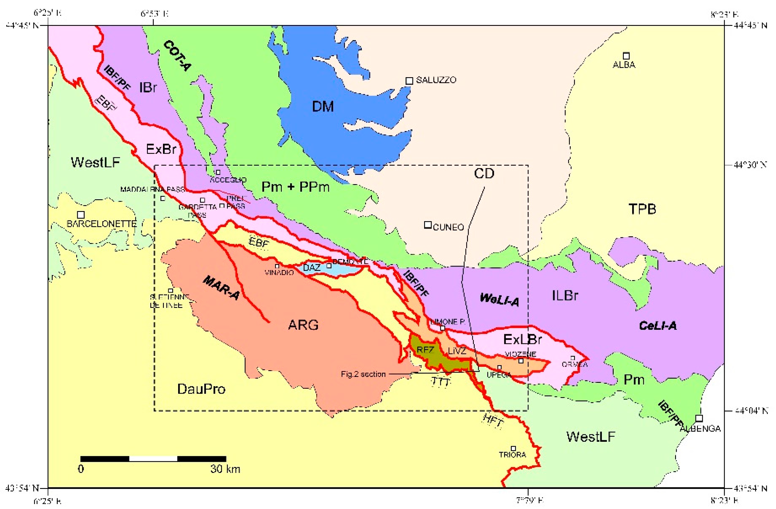
The southern termination of the Western Alps consists of three main geomorphologic sectors: a northwestern sector comprised between the Maddalena Pass and the Stura di Demonte valley, a central sector comprehending the Gesso Valley and extended eastward to the Tenda Pass and Vermenagna valley, and an eastern part, the western Ligurian Alps, here considered as the mountain range comprised between the Tenda Pass and the Tanaro valley (Figure 1). This region is very well suited for studying the relations between the Alps and the Apennines orogenic systems in terms of both the age of formation and the way in which the two main tectonic belts developed. This is mainly because: (i) the Maritime and Ligurian Alps formed later than other sectors of Western Alps [11,12,13,14]; (ii) they preserve, on top of their polymetamorphic basements, extensive Mesozoic to Oligocene sedimentary successions, which provide chronological constraints to the reconstruction of the regional tectono-sedimentary evolution, and (iii) the adjoining syn-orogenic basins recorded the tectonic history of both the two belts.
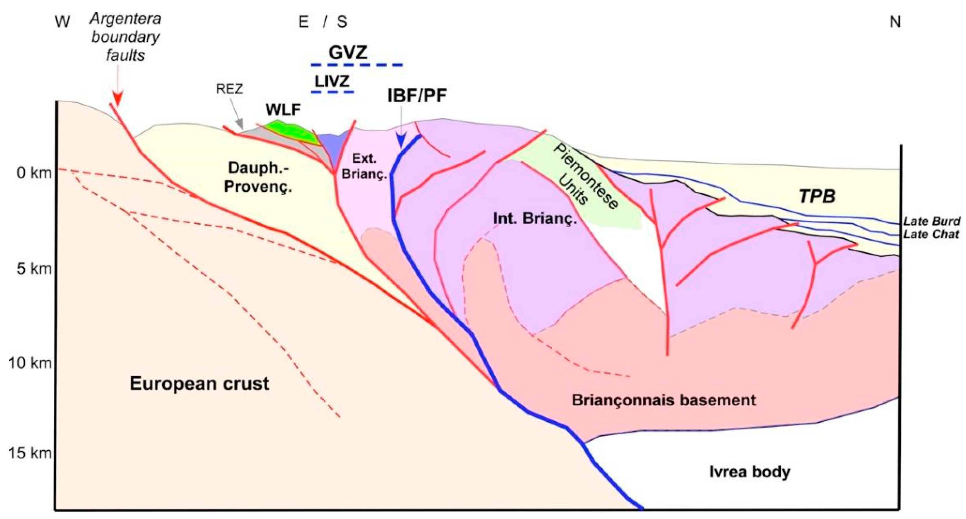
At the crustal scale, the SW Alps are interpreted as a composite tectonic belt detached at a depth of about 15 km in its north-eastern part and 5 km in the southwestern part, on the European crust. A high-density body (southern prolongation of the Ivrea body Auct.) occurs at a depth of about 40 km below the eastern margin of the SW Alps in southern Piemonte (Figure 2). The Ivrea body could have played an important role in the postcollisional Alpine tectonic evolution [15,16,17].
The first part of this paper concerns the analysis of the concepts (e.g., the Penninic Front and the Briançonnais Front) used in the literature to subdivide the SW Alps orogenic belts into domains that have different paleogeographic pertinence and/or show different geodynamic evolution, so that their effective relations with the other sectors of the Western Alps can be clearly defined. Once the main Alpine subdivisions are traced within the study area, a further analysis is carried out in the second part of the paper investigating how, when and at which extent the SW Alps were involved in the Apennine dynamics, which started during the late Oligocene when the westward-directed subduction of the Adriatic plate began [11,12,13,14,18].
This paper is thus based on the assumption that the evolution of the north-westernmost part of the Apennines can be studied referring to Alpine geodynamics because, although the Alps and the Apennines are two distinct geomorphologic and geophysical entities at the scale of the Western Mediterranean area [14], they share consistent kinematic evolution and common synorogenic basins in their junction zone of NW Italy. The steps of the Alps-Apennines evolution have been clearly recorded by a set of regional scale Oligocene to Pleistocene unconformities that can be continuously traced at surface in the southern part of the Piemonte region and in the subsurface of the western Po plain [19].

2. Geological Setting of the Southern Termination of the Western Alps

The southern termination of the Western Alps comprehends several tectonic units juxtaposed by NW-SE striking, mainly steeply dipping Alpine tectonic contacts. These units constitute the southern part of a double vergent structure developed at the regional scale [20,21] that involves the Briançonnais Domain in the internal northeastern side, and the Dauphinois-Provençal Domain in the external southwestern side [22,23]. The Briançonnais Domain, referred to as the distal part of the European continental palaeomargin of the Alpine Tethys [24], is subdivided by the Internal Briançonnais Front into an internal sector (Internal Briançonnais, mostly cropping out in the Cottian and Ligurian Alps) affected by HP-LT metamorphism [21], and an external sector affected by very low-grade metamorphism [25,26]. The Dauphinois-Provençal Domain, representing the proximal part of the European continental palaeomargin, was affected only by anchizone metamorphism, and is bounded along its inner side by the External Briançonnais Front. It may be subdivided into a basinal area where a several km-thick and clay-rich Mesozoic succession was deposited (Dauphinois succession), and a shallow water area, which is characterized by a reduced succession with carbonate platform facies (Provençal succession).
The more eastern part of the Western Alps southern termination, i.e., the western Ligurian Alps, shows a tectono-metamorphic and geometric setting [23,25,26,27,28,29] quite similar to that of the southern Cottian and Maritime Alps, although the fan-like, double-vergent structure is less pronounced than in the Maritime and southern Cottian Alps.
Finally, to the south of the External Briançonnais Front, in the investigated area the Western Ligurian Flysch units are present. These units, made up of Helminthoides Flysch-type successions [22,30,31,32] (also known as “Embrunais–Ubaye nappes” north of the Argentera Massif [33,34] and San Remo-M.Saccarello Unit to the SE of it [29,35,36]) are a stack of tectonic units composed of Lower Cretaceous–Lower Paleocene deep-water sediments referred to as the proximal Ligurian Domain and detached from their original substrate (i.e., the European continental margin). In the study area, the Western Ligurian Flysch, which were detached and emplaced in the early stages of the alpine tectonics [37], were later thrust over the Alpine Foreland Basin and/or the Dauphinois-Provençal succession, and are in turn involved in the Dauphinois-Briançonnais fold and thrust belt [23].

Tectono-Stratigraphic Evolution of the Southern Termination of the Western Alps

In the southern termination of the Western Alps, the Briançonnais domain represents a part of the more internal, uplifted sector, of the European distal margin, close to the Mesozoic Tethyan ocean (residual H-block [38,39]). The polymetamorphic Briançonnais basement crops out discontinuously in the Acceglio zone where it consists of micaschists, metabasites and granite. The overlying succession starts with Permian volcanic and volcaniclastic deposits and Lower Triassic fluvial to littoral conglomerate, quartzite sandstone and lagoonal pelite, followed by a Middle Triassic peritidal carbonate succession. The top of the Triassic succession is truncated by an unconformity due to a regional uplift and related subaerial exposure during the Tethyan syn-rift stage [40,41,42]. The succession continues with Middle Jurassic platform carbonates and Upper Jurassic pelagic plateau limestone, followed by mineralised Lower Cretaceous hard ground and Upper Cretaceous hemipelagic sediments.
The Dauphinois-Provençal domain represents the proximal margin of the Mesozoic Tethyan ocean [43,44] developed above the continental crust (i.e., the Argentera Massif in the study area). The succession starts with Carboniferous–Permian continental sediments and Lower Triassic coastal and lagoonal deposits, followed by Middle Triassic peritidal carbonates and Upper Triassic evaporites and lagoonal pelites. Starting from the Late Triassic–Early Jurassic, the Dauphinois-Provençal domain was affected by intracontinental rifting, and partitioned into fault-bounded rift-basins [41]. From the Early Jurassic to Early Cretaceous, the rift basins (Dauphinois domain) progressively subsided, and thick successions of deep-water marl, limestone and shale with interbedded resedimented calcirudite and calcarenite layers were deposited. Toward the south the Dauphinois domain passed laterally to a structural high (Provençal domain) that remained during the Middle Jurassic-earliest Cretaceous in shallow water conditions with the development of carbonate platforms [45]. In the Valanginian, the carbonate platform drowned and was covered by a few metres to a few tens of metres of condensed, open marine deposits locally rich in authigenic minerals (Hauterivian-Albian; [35,46]). The Dauphinois-Provençal succession ends with Upper Cretaceous hemipelagic marly limestone, locally rich in resedimented, mainly siliciclastic, layers [27,47,48].
The present geological setting of the Briançonnais and Dauphinois-Provençal domains of the southern termination of the Western Alps is mainly due to the progressive involvement of the European continental palaeomargin, which these domains belonged to in the Alpine tectonic belt since the middle Eocene (e.g., [34]). The first stages of this tectonic evolution caused the development, on top of the Mesozoic succession, of a regional unconformity corresponding to a hiatus spanning the latest Cretaceous–middle Eocene, overlain by the Alpine Foreland Basin succession [49], middle Eocene discontinuous continental to lagoonal deposits (Microcodium Formation), middle Eocene mixed carbonate–siliciclastic ramp deposits (Nummulitic Limestone), upper Eocene hemipelagic sediments (Globigerina Marl) and upper Eocene–lower Oligocene turbidite succession (Grès d’Annot, [50]).
Both the continental margin and the foreland basin successions have experienced, since the latest Eocene, a multistage tectonic evolution characterized first by southwestward brittle–ductile thrusting and superposed foldings, then by northeastward back-vergent folding and, lastly, by southward brittle thrusting and flexural folding [23]. The regional structural setting resulted from a transpressional regime [23,25,51], documented by a post-early Oligocene NW-SE transcurrent shear zone (Limone Viozene Zone) extending for some tens of kilometres through the study area. This shear zone is probably superimposed on a long-lived shearing corridor, active since the Jurassic–Cretaceous and reactivated during the Cenozoic [23,52].
In the southern termination of the Western Alps, the Alpine Foreland Basin succession is overthrust by the Helminthoides Flysch units (Western Ligurian Flysch units in [23]). The Helminthoides Flysch units [22,30,31,32] are composed of Lower Cretaceous–lower Paleocene deep-water sediments detached from their original substrate and referred to as the Ligurian Domain. These units consist of carbonate-poor, thin-bedded varicoloured pelites (the basal complex) interpreted as basin plain deposits, thick-bedded, coarse-grained sandstones deposited in internal deep-sea fans and thick-bedded, mainly carbonate turbidite successions deposited in external deep-sea fans [31].

3. The SW Alps Transfer

On the basis of the paleogeographic reconstructions proposed in the literature (see [53] with references therein), the geological evolution of the southern termination of the Western Alps arc (Figure 1 and Figure 2) was controlled, since at least the Early Cretaceous, by major transcurrent fault zones.
In the latest Eocene (35 Ma ago), the onset of the Europe-Adria continental collision induced the westward indentation of the Adria continental block, together with its high-density roots (Ivrea geophysical body [17]) and its counterclockwise rotation with respect to Europe, marking a dramatic change in convergence and thrusting direction (“Oligocene revolution” sensu [54]).
Figure 1. Geological sketch of the southern termination of the Western Alps. The main tectonic domains are represented with different colours. The black dashed rectangle corresponds to the study area of Figure 3. Legend: ARG: Argentera Massif; EBr: External Briançonnais Domain; IBr: Internal Briançonnais Domain; Pm: Piemonte Domain; PPm: Pre-Piemonte Domain; DM: Dora-Maira Domain; DauPro: Dauphinois—Provençal Domain; ExLBr: External Ligurian Briançonnais Domain; ILBr: Internal Ligurian Briançonnais Domain; TPB: Pliocene sediments and Tertiary Piemonte Basin; WestLF: Western Ligurian Flysch Domain; EBF: External Briançonnais Front; IBF/PF: Internal Briançonnais Front/Penninic Front; LiVZ: Limone-Viozene Zone; DAZ: Demonte-Aisone Zone; REZ: Refrey Zone; HFT: Helminthoides Flysch Basal Thrust; TTT: Tenda-tunnel Thrust; COT-A: Cottian Alps; MAR-A: Maritime Alps; WeLI-A: Western Ligurian Alps; CeLi-A: Central Ligurian Alps. The black line within the dashed inset refers to trace of the section of Figure 2. Adapted with permission from ref. [23]. Copyright 2016 Springer-Verlag Berlin Heidelberg.
Geosciences 11 00185 g001
At the same time, south of the Ligurian Alps, a switch in the subduction polarity occurred from a SE-dipping polarity to a W-dipping polarity, and the eastward retreat of the Apennine slab began, accompanied by onset of back-arc rifting in the Liguro-Provençal area [13,14,18,55]. Both these processes were quite absent to the north east of the Ligurian Alps, suggesting the presence of a major transfer zone between these two realms, which should have been oriented NNW-SSE in the first (early Oligocene) stages and WNW-ESE in the last (early-middle Miocene) ones ([9,23]. The activity of this major transfer zone, with active steep crustal tectonic features, extended at depth and allowed the west-ward indentation of Adria [34] that in the northern part of the Western Alps was accommodated by dextral shearing along the Periadriatic line [56]. Then, since the Oligocene, the transfer zone should have acted as a strike-slip fault zone along the southern margin of the Adria indenter [54]. This major transfer zone placed at the southern termination of the Western Alps may have developed partly on inherited Mesozoic extensional and transtensional faults active before the onset of the Alpine collisional regime (as discussed in [57]), which may have compensated for the different seafloor spreading rate of the Ligurian ocean to the south and Piemonte ocean to the north [34,53,54,58] Consequently, the geological units presently placed at the southern termination of the Western Alps arc should bear clear and widespread evidence of such distinctive geological evolution in terms of sedimentary evolution, deformational history and related hydrothermal activity.
A large amount of recently published data [23,25,26,27,28,46,52,57,59,60,61,62,63] document that since Early Cretaceous up to at least the early Miocene, the geological units presently placed at the southern termination of the Western Alps experienced a tectono-sedimentary evolution mainly related to large scale strike-slip and transpressive faulting, with significative migration of syntectonic fluids.
Figure 2. Schematic geological section (location in Figure 1) across the Argentera massif, the western Ligurian Alps and the TPB syn-orogenic basin. Reference data from [17,23,25,26,64,65]. Legend: TPB: Tertiary Piemonte Basin; GVZ: Gardetta-Viozene Zone; LIVZ: Limone-Viozene Zone; REZ: Refrey Zone; WLF: Western Ligurian Flysch (Helminthoides Flysch); IBF/PF: Internal Briançonnais Front/Penninic Front; Late Burd, Late Chat: seismic imaged unconformities of inferred late Burdigalian and late Chattian age.
Geosciences 11 00185 g002
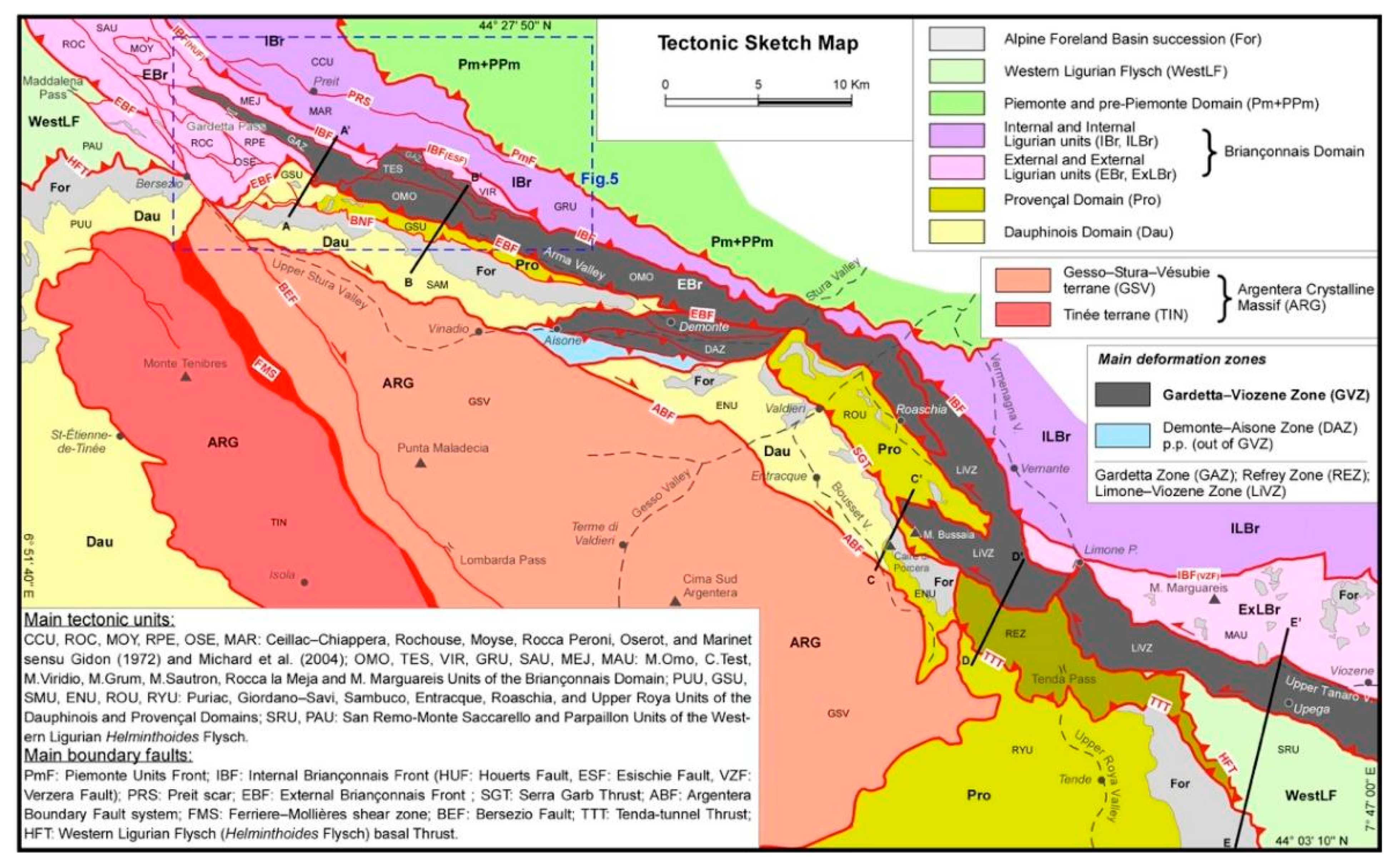
The field evidence of such an important, often invoked, transfer zone has been reported by [23] who described the southern termination of Western Alps arc as an assemblage of juxtaposed tectonic units, mainly belonging to the Briançonnais and Dauphinois-Provençal sedimentary domains of the palaeo-European margin and to the overlying Alpine Foreland basin, elongated on average ESE-WNW direction [20,47] within a km-scale transpressive deformation zone (SW Alps Transfer, SWAT). A progressive transition from high pressure metamorphic rocks in the internal (NE) part of the transfer zone, to very low grade and nonmetamorphic rocks in the external ones (SW) can be presently observed [21,23,26,66] (Figure 1 and Figure 3). The SWAT is probably rooted within the underlying European continental basement [16,17] (Figure 3) made up of mono and polymetamorphic rocks. These units crop out in the Argentera Massif, an ellipsoid-shaped body exhumed in Miocene times [67] through the Briançonnais, Provençal and Dauphinois sedimentary successions, from which it is presently separated on both sides by Miocene-Pliocene boundary fault systems [68] (Sanchez et al., 2011a) (Figure 1, Figure 2 and Figure 3).
Figure 3. Geological sketch map of the southern termination of the Western Alps adapted from [23]. The Gardetta-Viozene Zone is highlighted (in grey). The main tectonic units are represented referring to their different paleogeographic pertinence (different colors) and geometrical position with respect to the main tectonic boundaries and deformation zones. The location of geological cross-sections of Figure 4 (sections A-A’, B-B’, C-C’, D-D’, E-E’) is reported. The Internal Briançonnais Front (IBF) here corresponds to the external boundary of the green-schist to eclogite facies metamorphic axial belt of the Alps (sensu [69]) and can be thus considered as the surface expression of the Penninic Front.
Geosciences 11 00185 g003

4. The Penninic Front at the Southern Termination of Western Alps

To discuss the evolution of the southern termination of Western Alps in the frame of the collisional and postcollisional kinematics of the orogenic belt, it is necessary to unambiguously define the intended meaning of the “Penninic Front concept”, in order to understand what are the relations of the SWAT with the ideal main tectonic boundary of the Western Alps belt, i.e., the so-called Penninic Front. Before starting to debate on this matter, a brief examination of the historical intended meaning(s) of the “Penninic Front concept” is given in the following.
The Penninic nappe stack can be seen, in a very simplified view, as the suture zone between the European (including the Briançonnais domain) and Adriatic plates, comprising remnants of the former subducted oceanic crust or exhumed mantle, as well as the extended European continental crust [70]. A slightly different, definition of the Penninic zone is given by Dal Piaz (ets al.) [71], as a stack of generally metamorphic nappes scraped off the subducting oceanic lithosphere and European passive continental margin (distal part), mainly accreted during the Paleogene, whose outer boundary is the Penninic frontal thrust.
In many other papers [16,34,72,73] the Penninic domain has been conceived differently from the above cited papers because the Penninic frontal thrust (Penninic Front) has been placed in the Southwestern Alps at the boundary between the Briançonnais and Dauphinois-Provençal domains, irrespective of the distribution of the metamorphism. Further south, the Penninic Front has been placed along the external boundary of the nonmetamorphic Western Ligurian Flysch Unit (Helminthoides Flysch Units) of the SW Alps, which is detached over the Dauphinois-Provençal domain, and labelled as Penninic Basal Contact or “AlpineThrust Front” [29,37].
In this paper, the Penninic Front is intended (in the sense of [69]) as the frontal thrust which bounds the Alpine Axial Belt, which comprises continental units derived from the Adriatic margin (“Austroalpine units”), as well as parts of the European continental margin together with oceanic units originated from the Mesozoic Piemonte–Liguria Ocean, labelled together as “Penninic Units” (Figure 1). All these units of the Alpine Axial Belt underwent alpine metamorphism ranging from greenschist facies to ultra-high-pressure eclogite facies conditions. The Penninic Front bounds the penninic units from the less metamorphosed external parts of the paleoEuropean margin, which can pertain to the External Briançonnais, Helvetic, and Dauphinois-Provençal domains.

5. Structure of the Southern Termination of the Western Alps: Increasing Deformation, Metamorphism and Relations with the Adjoining Alps-Apennines Syn-Orogenic Basins

A review of the tectonic setting and evolution of the southern termination of the Western Alps, as well as the dating of its main stages, is necessary to provide the elements to correlate it with the evolution of the northernmost part of the Apennines belt. We specify that the following description of the metamorphic conditions of the tectonic units refers to the “metamorphic degree”, defined on the basis of mineralogical indexes (such as the ‘crystallinity’ degree of phyllosilicate minerals [26]), even for the very poorly transformed rocks of the external Briançonnais and Dauphinois-Provençal domains, which were subjected to anchizonal or very low-grade metamorphic conditions [26]. Conversely, if textural criteria are used to define the metamorphic features in the study area [19,74], the rocks of the studied external Briançonnais and Dauphinois-Provençal domains would be classified as “nonmetamorphic”, since their primary features are mostly preserved from the effect of secondary petrogenetic processes and do not show any major internal reorganization or recrystallization.
The overall aspect of the southern termination of the Western Alps is presently a fan-like setting that evokes a flower structure, well known in the Briançonnais domain of the Guillestre, Briançon and Moûtiers transects [75,76,77,78,79], as well as in the Maritime Alps (Stura valley and Tenda Pass area [27]) and western Ligurian Alps [23,25,26,29,80].
This double-vergent tectonic system [20,21] involves the Briançonnais Domain in the internal, northeastern side and the Dauphinois-Provençal Domain in the external, southwestern side [22,23]. This system consists of NE-vergent thrusts and transpressive fault systems developed to the north of the External Briançonnais Front, and SW-vergent ones to the south of it. In map view (Figure 1), the external and internal Briançonnais Fronts, as well as the frontal thrust of the Piemonte Zone, get closer to each other from west to east, while changing their directions from NW–SE to west–east, almost merging together in the Stura valley, east of Aisone (Figure 1 and Figure 2). Due to the deflection of tectonic fronts and the consequent strong reduction in thickness of the main structural domains, the transition from the HP-LT metamorphic units of the internal Brianconnais to the very low-grade units of the external Briançonnais and Dauphinois-Provençal domains occurs over a relatively short distance (about ten kilometers) along a NE-SW oriented geological section (Figure 1, Figure 2 and Figure 3). The eastward prolongation of the tectonic stack made up of the Piemonte Zone and the Internal Briançonnais tectonic domains, is concealed by the sediments of TPB and overlying Pliocene and Quaternary successions: see [19] with references therein. At the southern termination of the Western Alps, the transition between the internal Alpine metamorphic tectonic prism and the external Briançonnais-Dauphinois-Provençal fold-and-thrust belt occurs.
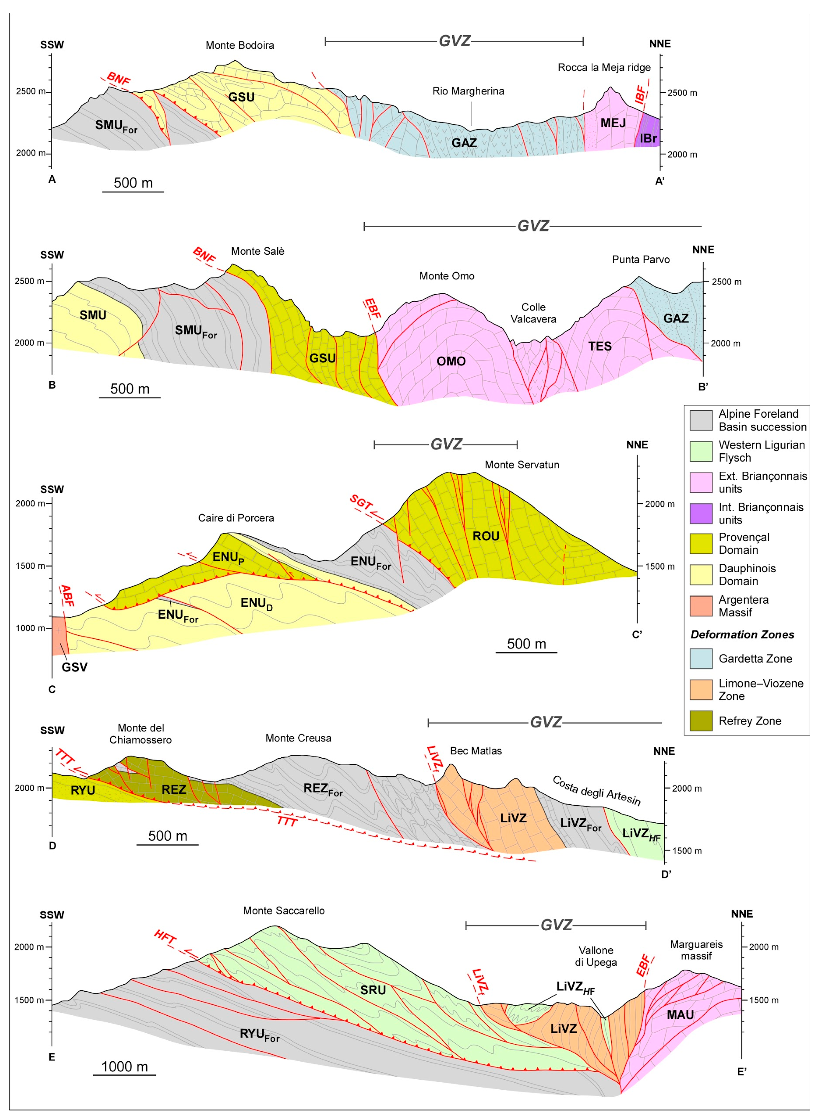
This geological transect is suitable for investigation of how the postsubduction Alpine tectonic evolution has been recorded since the early Oligocene by the adjoining syn-orogenic basins of the Piemonte region, whose tectono-sedimentary setting was controlled, at least since the late Oligocene, by the beginning of the Apennines subduction and related surface tectonics. In this way, a correlation between the Alpine and Apennine main tectonic events can be attempted, as discussed in the following sections. As reported in Section 3, in the southern termination of the Western Alps there is evidence of a major transfer zone (the SWAT) represented by an assemblage of juxtaposed tectonic units, mainly belonging to the Briançonnais, Dauphinois-Provençal and Alpine Foreland Basin sedimentary domains, elongated on average in an ESE-WNW direction [23]. The SWAT represents an ideal macroscale tectonic feature, whose existence can be inferred on the base of kinematic modeling at the regional scale [15,34,81]. A number of effective deformation units (sensu GeosciML), and/or strongly deformed tectonic units, exist in the southern termination of the Western Alps, which are defined in Figure 2, Figure 4 and Figure 5 and listed as follows, starting from the more internal units in the footwall of the IBF: (a) the steepened Triassic dolostone succession of the Rocca la Meja unit; (b) the Gardetta Deformation Zone, consisting of several deformation units made up of Carboniferous (?)-Permian (?) volcanics and schists, Triassic quartzarenite, quartzite and km-scale slices of gypsum, intensively folded and steepened along the WNW-ESE faults that bound and dissect the deformation zone; (c) the steepened and strongly sheared external Briançonnais M.Omo Unit and Provençal Giordano-Savi Unit; and (d) the Demonte- Aisone deformation unit of [23]; (e) the tectonic slice system of the Roaschia Unit [27], which passes laterally to the transpressive Limone-Viozene Zone [23,25]. All these units share a succession of geologic events and related mesoscale regional foliations, as well as consistent kinematic features, that formed in response to a succession of deformation phases as described in the following. The assemblage of the above-described tectonic units is here labelled as the Gardetta-Viozene Zone (GVZ), which can be interpreted as the effective representation of the SWAT.

5.1. Rock Deformation and Metamorphism across the IBF in Southern Cottian Alps

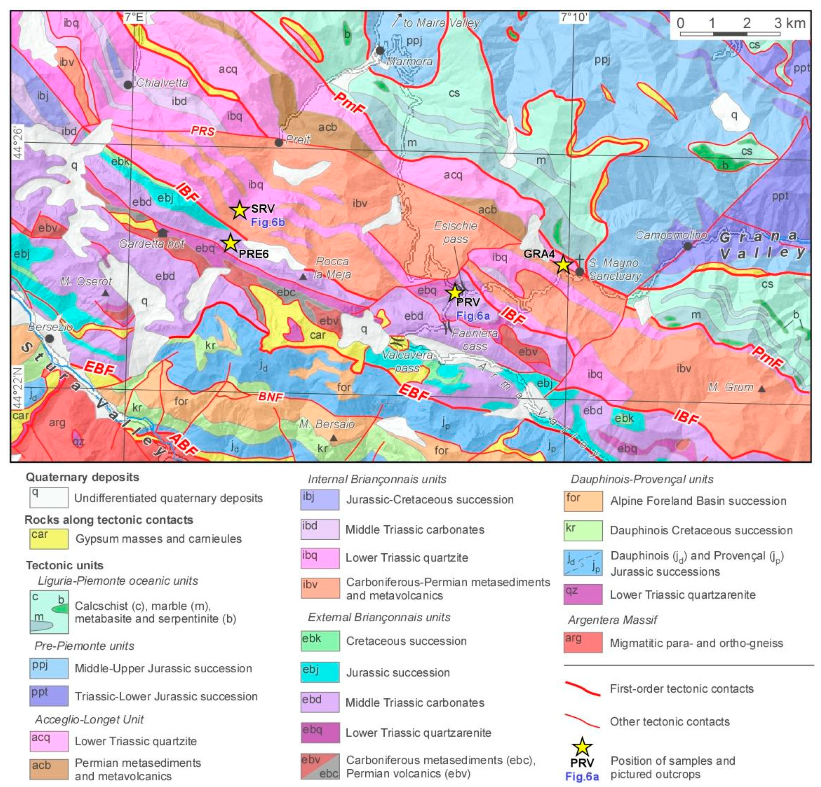
The transition from the green-schist facies metamorphic rocks of the internal Briançonnais to the anchizonal external Briançonnais, which occurs across the IBF, can be observed through the watershed between the Grana and Arma valleys (San Magno-Fauniera Pass area) and along the Preit-Gardetta transect in the right side of the Maira valley (Figure 5). Near San Magno, the Permian (?)-Early Triassic conglomerate and quarzarenite [47] of the internal Briançonnais (site GRA4 in Figure 5) are transformed into greenschist gneisses, while in the Fauniera Pass area (External Briançonnais) they crop out as a very poorly stretched conglomerate with pink quartz and rhyolite pebbles (sample PRV in Figure 5 and Figure 6a,c). Similarly, in the Preit valley, the Permian (?)-Early Triassic quartzite have a marked gneissic structure (sample SRV in Figure 5 and Figure 6b,d), while the quartzarenite and dolostone cropping out SW of the IBF, in the Rocca la Meja tectonic slice do not show evidence of major metamorphic transformations, as also suggested by the presence of preserved microfacies in the Triassic dolostone (sample PRE6, Figure 6e) and very well-preserved Archosauriform footprints recently discovered [82] a few hundred meters from the IBF. The IBF cuts across the Middle-Upper Triassic evaporites and the Lower Triassic quartzite/quartzarenite layers, which, conversely, in the external (SW) part of the GVZ and in the fold and thrust belt comprised between the IBF and the Argentera northern boundary faults, are not displaced by high angle faults and seem to have played a role of regional detachment horizons.

5.2. Field Constraints to the Age of Tectonic Events and Kinematic Interpretation

5.2.1. Tectonic Phases

The southern termination of the Western Alps shows structural and metamorphic characters acquired through a succession of three “phases of deformation” (D1–D3) with prevalent folding and thrusting, followed by a transpressive, mostly disjunctive phase (D4) and a late (D5) extensional phase.
-
D1: this phase is associated with an early phase of décollement tectonics responsible for the piling up of the Briançonnais duplexes by mostly bedding-parallel thrusts, mainly vergent to the SW (present geographic coordinates), as shown by [76] in the Briançon area, [21] in the Ubaye-Maira transect and by [23,25,83] in the Maritime and Western Ligurian Alps. The D1 phase is assumed to be roughly consistent with a regional E-W shortening direction [84].
The D1 was probably characterized by transpressional kinematics, since the sedimentary successions were shortened by duplexes and steepened (Figure 7a) after being detached from the Triassic gypsum and quartzite/quartzarenite levels, while the S1 foliation developed mostly parallel to the steepened bedding [21,25]. With the D1 related strain, a regional scale transpressional deformation unit formed, developed mainly at the expense of the external Briançonnais and inner Dauphinois-Provençal domains, which can be still recognised from the high Stura valley to the Tanaro valley (Figure 2) [23] within the GVZ. Gypsum masses of Triassic age [47] are involved in the GVZ (Figure 7b and Figure 8e,f), probably dragged from the basal detachment level placed at the base of the external Briançonnais and Dauphinois-Provençal succession where these rocks largely occur [23,85,86].
The D1 phase generated the oldest composite tectonic foliation (S1, [87], locally axial-planar to F1, SW verging recumbent folds and syn-D1 reverse/sinistral shear zones (“charriages” Auctorum; [20,88]) Gidon, 1972; Lefèvre, 1983), within which the S1 foliation (Figure 7c,d,f) formed mostly parallel to the boundary shear planes [23]. Evidence of the D1 phase in Dauphinois-Provençal Domain is poorly documented at the mesoscale, except for the Giordano-Savi unit close to the EBF in the left side of the Stura valley, where D1 folds are preserved (Figure 8b) but rotated and displaced by syn-D2/D3, SW-vergingSW vergent thrusts, with related drag folds (M. Bodoira, Figure 4).
At the end of the D1 phase, local transtension should have occurred in some parts of the GVZ, as inferred by the activity of relatively hot fluids, which circulated along NW-SE fault systems, that led to the formation of hydrothermal marbles at the expense of the Jurassic-Cretaceous Dauphinois succession (Valdieri marble, [63]) and to intense recrystallization of some parts of the Alpine Foreland Basin succession (Aisone Flysch, [23,63,89]).
Figure 4. Geological cross-sections across the Gardetta-Viozene Zone (GVZ; location in Figure 3); modified from [20] (sections AA’, BB’); [27] (sections CC’, DD’); [26] (section EE’). Tectonic units: ENUD: Dauphinois succession of Entracque Unit; ENU, For: Foreland Basin succession of Entracque Unit; ENUP: Provençal succession of Entracque Unit; GAZ: Gardetta Zone; GSU: Giordano–Savi Unit; GSV: Gesso–Stura–Vésubie terrane; IBr: internal Briançonnais units; LiVZ: Limone–Viozene Zone; LiVZFor: tectonic slices of Foreland Basin succession involved in the Limone–Viozene Zone; LiVZHF: tectonic slices of Western Ligurian Flysch Unit involved in the Limone–Viozene Zone; MAU: Monte Marguareis Unit; MEJ: Rocca la Meja Unit; OMO: Monte Omo Unit; SMU: Sambuco Unit; SMUFor: Foreland Basin succession of Sambuco Unit; TES: Cima Test Unit; REZ: Refrey Zone; REZFor: Foreland Basin succession of the Refrey Zone; ROU: Roaschia Unit; RYU: Upper Roya Unit; RYUFor: Foreland Basin succession of Upper Roya Unit; SRU: San Remo–Monte Saccarello Unit. Main boundary faults: ABF: Argentera boundary fault system; BNF: Bersaio–Nebius Fault; EBF: External Briançonnais Front; HFT: Helminthoides Flysch basal Thrust; IBF: Internal Briançonnais Front; LiVZf: external boundary faults; SGT: Serra Garb Thrust; TTT: Tenda-tunnel Thrust.
Geosciences 11 00185 g004
Figure 5. Geological map of the Gardetta highland area (modified from [19]), showing the sampling points of samples PRE6, PRV, and SRV and the position of outcrops pictured in Figure 6a,b. ABF: Argentera boundary fault system; BNF: Bersaio-Nebius Fault; EBF: External Briançonnais Front; IBF: Internal Briançonnais Front; PmF: Liguria-Piemonte units Front; PRS: Preit fault (“Preit Scar”).
Geosciences 11 00185 g005
-
D2/D3: these two cogenetic tectonic phases generated double-vergent fold systems (with predominant top to NE and subordinate top to SW vergence sense of shearing, D2) evolving to a transpressi shearing onal regime (D3), with high-medium angle reverse and strike-slip faults (Figure 8a) and related minor folds, roughly consistent with E-W regional shortening directions (D2), shifting to NE-SW directions (D3) [9,23,90]. Diffuse fault block rotations on vertical axis and reactivation of faults occurred during the D2, as in the case of the sinistral Preit fault (Figure 2). This major strike-slip fault displaces the boundary of the Internal/External Briançonnais units (i.e., the Internal Briançonnais Front, IBF), attesting that the D2 phase mostly postdates the metamorphic evolution of the units involved in the southern termination of Western Alps.
The folding phase D2 folded the D1 duplexes and reactivated the D1 steep transpressive shear zones (Figure 8c,d). A well-developed spaced crenulation cleavage (S2) is associated with F2 folds (Figure 7c–f). S2 planes are in several places reactivated and reoriented by shear deformation (S2-shear, generated by the D3, Figure 7e,f) kinematically consistent with the D2 phase that often induced the displacement or partial transposition of F2 folds hinge zones [25]. In the major transpressive shear zones (LiVZ), the S1 and S2 surfaces are almost subparallel and often form a composite foliation [25] (Figure 6c).
Figure 6. (a) Permian (?)-Early Triassic interbedded conglomerates and sandstones made up mainly of quartz and volcanics clasts. External Briançonnais Domain (Viridio Unit), Fauniera Pass area. (b) Permian (?)-Early Triassic quartzitic-rhyolitic metaconglomerate and metasandstone, Internal Briançonnais Domain (near Preit village), showing isooriented and stretched clasts that mark a gneissic structure. (c) Transmitted-light, crossed polars photomicrograph of sample PRV (external Briançonnais Domain, Fauniera Pass area; location in Figure 5), a coarse lithic sandstone corresponding to the finer levels of Figure 7a. A poorly defined lamination is evidenced by grain size variations. (d) Transmitted-light, crossed polars photomicrograph of sample SRV (internal Briançonnais Domain, Preit Valley; location in Figure 5), a metalithic sandstone corresponding to the finer levels of Figure 7b. A well-defined foliation is evidenced by the iso-orientation of the arenitic grains and by the occurrence of sub-millimetre thick levels of neoblastic iso-oriented white mica. (e) Transmitted-light photomicrograph of sample PRE 6 (Rocca la Meja tectonic slice, near the GVZ inner boundary, location in Figure 5), a dolomitized grainstone with oolites, echinoderm fragments and other bioclasts. Note the well-preserved morphology and internal structure of the oolites. (f) Transmitted-light photomicrograph of bioclastic arenaceous limestone (Eocene Nummulitic Limestone, Alpine Foreland Basin succession) from a tectonic slice within the LIVZ, Lago dei Signori pass, Marguareis area. Although a mm-scale foliation is present, evidenced by pressure dissolution seams and cataclastic levels, no volumetric dissolution or recrystallization occurred, as documented by the very well-preserved macroforaminifera and bryozoan.
Geosciences 11 00185 g006
The S1/S2 foliation is clearly reoriented and reactivated by the D3 shearing event in all the sectors of the GVZ, from the Gardetta Pass to the Marguareis area. The S2 cleavage is well exposed in the Ligurian Briançonnais units (Marguareis area [25,83]) due to the presence of the Upper Cretaceous marly limestone (Upega Formation) that recorded it with clear evidence. Conversely, this important regional foliation is poorly represented in the external Briançonnais units cropping out to the North of the Stura Valley, where, although present, it can be less frequently observed (Figure 7d).
-
D4: faulting events related to the final uplifting stages of the Argentera Massif, inducing reactivation of D3 reverse and strike-slip fault systems and a minor rearrangement of the D1/D2 structural setting. During this stage, the compression direction is assumed to have rotated from NE–SW and then to N–S, inducing the reactivation of SW-verging reverse faults into dextral transpressive faults [15,17,34,68,90].
Among the main evidence for the D4 phase are the boundary faults of the Argentera Massif, with the related huge mass of gypsum-bearing brecciated fault rocks (Carnieules Auct. [47]) aligned all along the boundary faults of the massif.
-
D5: the late stage of the tectonic evolution of the southern termination of the Western Alps was achieved in a general extensional-transtensional regime [67,68] as it represents a transitional zone between the regions affected by extension, located in the inner part of chain, and those affected by strike-slip and contractional tectonics, located in the outer parts of the alpine belt. A general frictional reactivation of the previously existing NW-SE to E-W fault systems occurred at this stage [90].

5.2.2. Age of Tectonic Phases and Metamorphism

The southern termination of Western Alps shows a metamorphic evolution ranging from anchizonal and very low-grade facies in the Dauphinois-Provençal and external Briançonnais domains to low grade, high-pressure greenschist facies and carpholite-quartz (blueschist) facies in the internal Briançonnais domain: see [21] with references therein) and [26]. In the more internal Briançonnais and prePiemontese successions, as well as the Acceglio zone, adjoining to the study area the metamorphic degree reached the eclogite facies; see [91] and [21] with references therein.
The metamorphic conditions and the ages related to the above-described tectonic phases are described in the following.
-
D1 phase. The HP metamorphic transformations recorded by the Internal Briançonnais units were acquired before the D1 phase, as evidenced by the relations between the HP minerals and the tectonic foliations (D0 in this paper, D1 [21]). The metamorphism occurred in a time span between the age of the phengite in the Triassic quartzites (37 Ma [92]) of the adjoining, more internal, Pelvo d’Elva unit, and that of the very low grade S1 foliation (see below). In the external sectors, the D1 phase described in this paper, here intended as the older deformation phase that gave origin to a penetrative foliation, occurred later and at a temperature lower than 300 °C [21,26]. Its age should be younger than 33–34 Ma, i.e., the age of the upper part of Grès d’Annot successions [93] involved in the external Briançonnais tectonic units [20,23,47]. Furthermore, the metamorphic HP-LT transformation along the Penninic Front fault rocks in the Pelvoux area, during its later reactivation, has been dated at 34–30 Ma [77,84], thus ascribing it to the D1 phase.
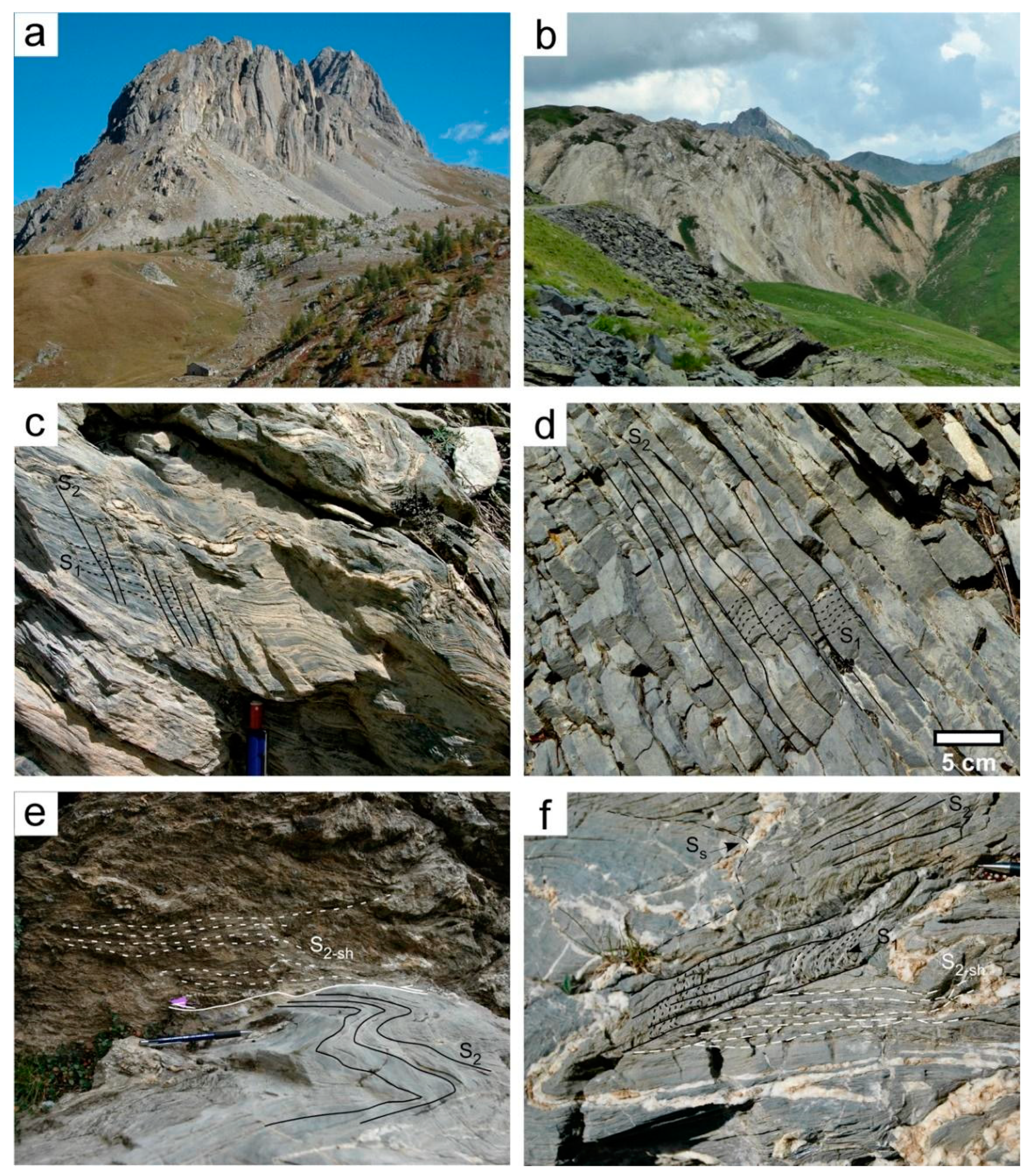
Figure 7. (a) The sub-vertical Triassic dolostone succession of Rocca la Meja (Meja unit, GVZ, Gardetta highland). In the foreground (right lower corner) an outcrop of steepened Lower Triassic quartzarenite of the Gardetta Deformation Zone is visible. (b) Intensively folded and steepened gypsum within the Gardetta Deformation Zone. (c) Upper Cretaceous marly limestones in the external part of the GVZ (Dauphinois-Provençal succession) close to the Tenda pass showing a well-developed spaced crenulation cleavage (S2, black lines), crosscutting the older S1 foliation (black dashed lines). Note that in this area the S2 is NE-dipping. (d) Upper Cretaceous marly limestone in the External Briançonnais M. Omo Unit, close to Valcavera pass showing a well-developed spaced crenulation cleavage (S2, black lines), crosscutting the S1 foliation (black dashed lines). (e) Strain localization along the lithological contact between Upper Cretaceous marly limestone (Upega Fm.) and Upper Jurassic grey limestone (M. Marguareis, Ligurian Briançonnais domain). The S2 spaced cleavage (black lines) is dragged by S2-shear planes (S2-sh, white dashed lines) developed during the late stages of D2 and probably also during the D3 phase. (f) Upper Cretaceous marly limestones of the External Briançonnais succession in the Limone-Viozene Zone, Marguareis area. A well-developed spaced crenulation cleavage (S2, black lines) was generated as axial planar surfaces of F2 folds that folded both bedding and older foliation S1 (black dashed lines). Locally, S2 surfaces evolved from an axial plane foliation to a slip cleavage (S2sh, white dashed lines), giving origin, in some places, to dm-thick shear zones, which reoriented all the pre-existing foliations.
Geosciences 11 00185 g007
The radiometric age of the late D1 hydrothermal fluids responsible for the formation of the Valdieri marble (see above), defined at 30–31.6 Ma by U-Pb analyses on recrystallised and vein carbonate and neoblastic silicate minerals, provides a useful constraint for dating not only the D1, but also the D2 phase, which clearly postdates the marble [63]. It is remarked that a major gap in the distribution of metamorphism is not recorded across an ideal internal Briançonnais-Dauphinois cross section, i.e., across the front of the alpine tectonic prism, as occurring in other orogens (e.g., across the Himalayan main thrust front [94]), but the decrease of the metamorphic grade from the inner to the outer tectonic units seems to occur gradually (see above, Section 5.1), although a relatively major boundary can be established along the internal Briançonnais Front, corresponding to the “Penninic Front” in the sense of the assumption defined in Section 4, following [69].
-
D2/D3 phase: since the metamorphic HP-LT transformation along the Penninic Front fault rocks in the Pelvoux area, during its syn-D1 reactivation, has been dated at 34–30 Ma [77,84], the D2 phase, which is consistent mainly with very low-grade metamorphism and pressure-dissolution processes of carbonate rocks [25,26], should be younger than 30 Ma. Zircon fission track data ([9] with reference therein) indicate that the western Ligurian Briançonnais basement was at about 265–215 °C between 32 and 29 Ma, suggesting that the onset of the very low-grade to anchizonal D2 phase should have occurred after that time span, i.e., at least since the late Rupelian. U-Pb radiometric age on recrystallized carbonate matrix (24.7 ± 6,9 Ma) and calcite veins (26 ± 11 Ma) in Lower Cretaceous deposits of the Entracque Unit [95], which could be referred to as the last event of diffuse recrystallization and pressure dissolution (ascribable to the D2/D3 phase), thus occurred around 25 Ma, confirming what suggested above.
Other constraints for dating the D2/D3 phases are provided by the faults of the northern part of the Argentera Massif [96]. The kinematics of these faults have been related to the shifting of the regional shortening to N-S directions, which is here thought as the reason for the shearing evolution of the D2 folding phase, i.e., the D3 phase. This occurred probably between 26 Ma and 20 Ma when the D3 phase induced the main uplifting of the Argentera Massif, controlled by dextral transpression along NW-SE fault systems [68,97]. In this time span, the internal sectors of the uplifting SW Alps crossed the apatite fission track closure temperature of 120 °C [9], while in the external sectors (Argentera and Dauphinois-Provençal) this occurred at about 14–12 Ma [68]. These data suggest that after the D3 phase, the tectonic evolution (D4 and D5 phases) should have been characterized by development of purely brittle discrete fault systems and/or individual faults.
The D2 NE-vergent tectonics recorded in the external Ligurian Briançonnais have been ascribed to the late Oligocene also by [29].
Figure 8. (a) Slickensided strike-slip fault surface bounding the GDZ on its southern side along the EBF (Dogger limestones of M. Bodoira); (b) steepened folds affecting the Jurassic-Cretaceous successions close to the EBF in the M. Bodoira tectonic unit; (c) subvertical, intensively sheared beds in the hundred-meters scale “Servagno transcurrent zone”. This zone is located on the GDZ southern boundary, along the EBF and it affects the Jurassic-Cretaceous succession of M.Bodoira near Servagno pass. (d) Detail of Figure 10c, drag folds showing vertical axes and vertical axial planes developed along the individual strike-slip faults of the Servagno transcurrent zone; (e) tight to isoclinal folds in the gypsum masses of the GDZ to the west of Valcavera pass; (f) major gypsum tectonic slices in the central part of the GDZ, bounded by steeply dipping faults belonging to the EBF fault system (in the background the vertical tectonic slices of Monte Salè, reported in the cross-section of Figure 4).
Geosciences 11 00185 g008
During the D2/D3 time span the uplifting was recorded by the sedimentary evolution of the adjoining internal syn-orogenic basin, the so-called Tertiary Piemonte Basin, which in the sector close to the Ligurian Alps is characterized by localized fault bounded basins whose tectono-sedimentary evolution has been interpreted as controlled by transtensional and strike-slip tectonics since the late Rupelian [9,10,65].
-
D4 phase: N-S regional shortening continued to be active from the early Miocene until the Tortonian-Messinian from the Ligurian Alps to the Apennines (Padane) thrust front, and is recorded in the southern termination of the Western Alps mainly as dextral transpression along the NW-SE fault systems subparallel to the main Briançonnais and Dauphinois tectonic fronts and the boundary faults of the Argentera Massif [68,98].
-
D5 phase: the late extensional and transtensional regime occurred during the late Miocene-Pliocene [67,68], which was coeval to the strike slip and contractional tectonic regime of the outer sectors of the SW Alpsto the south of the Argentera Massif and in the northern margin of the present Ligurian basin [64,90].

5.3. Subsurface Stratigraphic Constraints to the Uplifting Stages

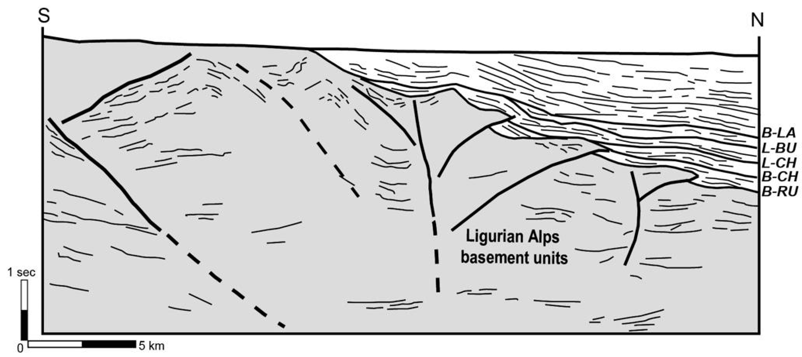
The eastern extension of the SWAT/GVZ system (as described in previous sections) can be traced in the Cuneo-Mondovì area. In this area, outcrop and subsurface data constrain the tectono-depositional evolution of Oligocene to Miocene synorogenic basins developed on the western Alpine basements: see [7] and references therein. The line drawing in Figure 9 (SL1, [65]) refers to a N-S seismic line running from the Ligurian Alps to the adjacent plain. It shows strike-slip faults with flower geometries, deep-seated in the western Ligurian Alps basement. During the Oligocene and early Miocene, these faults (roughly E-W striking in map view) controlled evolution of basins (presently buried below younger successions) filled by continental to marginal marine/slope successions [7] and laterally equivalent to the cropping out eastern TPB successions (Molare and San Paolo formations [99,100]). Unconformities and onlap terminations point out the progressive Oligocene to Miocene syntectonic uplift of this part of the Ligurian Alps.
Figure 9. Seismic line drawing crossing the TPB sediments in the subsurface of the Cuneo-Mondovì area. The unconformities are base Rupelian (B-RU), base Chattian (B-CH), late Chattian (L-CH), late Burdigalian (L-BU) and base Langhian (B-LA). From [7,65].
Geosciences 11 00185 g009

6. Discussion: The Late Eocene to Miocene Evolution of the Internal SW Alps in the Frame of the Adria Indenter Kinematics and First Stages of the Apennines Orogenesis

Some points for discussion on the relations between the kinematic evolution of the SW Alps and the Adria indenter in the frame of the ongoing Apennines orogenesis, are here proposed.
(a)
The first point concerns the dynamic context in which the exhumation of the alpine units occurred. As reviewed in the above sections, it can be suggested that the exhumation of the tectonic units derived from the Briançonnais, Dauphinois-Provençal and Alpine Foreland basin domains occurred in a transpressional regime. It was stated by [21] that whereas the exhumation of the adjoining Alpine units, such as the Dora-Maira UHP-HP eclogite rocks and the Monviso meta-ophiolites, mostly occurred through extrusion in the subduction channel and then late extensional tectonics, “the Briançonnais nappes were exhumed mostly through transpressional deformation at the bottom of a collapsing and eroded orogenic wedge”. This interpretation is consistent with the ideas sustained in this paper, and is supported by: (i) the overall structural setting of the Briançonnais-Dauphinois-Provençal transect in the SW Alps, corresponding to a mega-macroscale fan-like geometry evoking a flower structure; (ii) the transpressional characters of the structural associations developed in the D1–D3 phases, consisting of several juxtaposed tectonic domains dominated, in turn, by steep reverse and strike-slip faults, low-angle thrust surfaces and folded domains with alternating low-angle axial surface folds and vertical axes folds; (iii) the progressive and gradual decrease of the metamorphic grade from the internal Briançonnais to the external Dauphinois-Provençal units, indicating that no major vertical offset, and no related metamorphic gap, occurred across the tectonic unit boundaries; (iv) the tectono-sedimentary setting of the adjoining syn-orogenic basins placed in the internal side of the Western Alps, in southern Piemonte, that recorded the kinematics and uplifting stages of the Alps tectonic belt.
The subpoint (ii) demands further considerations on the geometrical setting of the GVZ, which has been described in detail only for its eastern part (LIVZ, [23,25]). The western part of the GVZ, consists of a number of tectonic slivers made up of different rock types arranged in a km-scale deformation zone (Gardetta Deformation Zone, Figure 10) developed between the internal (IBF) and the external (EBF) Briançonnais fronts. The tectonic slices are made up of both the rocks of the internal Briançonnais domain (metavolcanics and volcanoclastite, phyllite, quartzite and meta quartzarenite) and of the external Briançonnais (volcanoclastite, quartzarenite and parts of the Triassic-Cretaceous carbonate succession), as well as gypsum masses derived probably from the base of the Briançonnais or the Dauphinois successions. The slices are separated by steeply dipping tectonic contacts, oblique to the GDZ boundaries, and consisting of individual faults showing strike-slip slickensided surfaces (Figure 8a), or transcurrent shear zones. The internal setting of the slices can be represented by contractional structural associations (thrusts with related ramp folds, symmetrical folds in the core of the GDZ, Figure 8b) and/or by transcurrent strained domains showing drag folds with subvertical axes and axial planes (Figure 8c,d), and subhorizontal extension lineations. The huge gypsum masses involved in the GDZ show isoclinal to tight folds with axial planes subparallel to the bedding (Figure 8e) but are always bounded by steeply dipping faults (Figure 8f). Although the detailed description of the GDZ structural setting is beyond the scope of the paper, we believe that a qualitative interpretation of the GDZ as a strain-partitioned transpressive zone should be accountable on the basis of the above reported observations, as well as the overall geometric setting on map view (Figure 10). The macro and mesoscale features of the GDZ seem to fit with the diagnostic features described for the transpressive zones in the basic works of [101,102,103]. Furthermore, the abundant presence within the GDZ of lithotypes that rarely occur in the external Briançonnais domain (e.g., the basic volcanics of the Becco Nero slices, Figure 10) suggest that the GDZ could have originated on some prealpine lithological inhomogeneity.
(b)
The second discussion point refers to the effective relations of the transpressive tectonics, discussed at point (a), with the inferred presence of the regional transfer zone, here named SWAT (see Section 3), that should have contributed to the west-ward indentation of Adria and its counterclockwise rotation with respect to Europe [34]. This transfer kinematics, coeval with the continuing shortening due to the Adria-Europe indentation, seems to be effectively recorded by the structural setting of the southern termination of Western Alps, namely by the Gardetta-Viozene Zone (GVZ), consisting of an assemblage of transpressive deformation units [20,23], which can be followed quite continuously from the NW in the Cottian Alps to the Tanaro valley in the western Ligurian Alps (Figure 3).
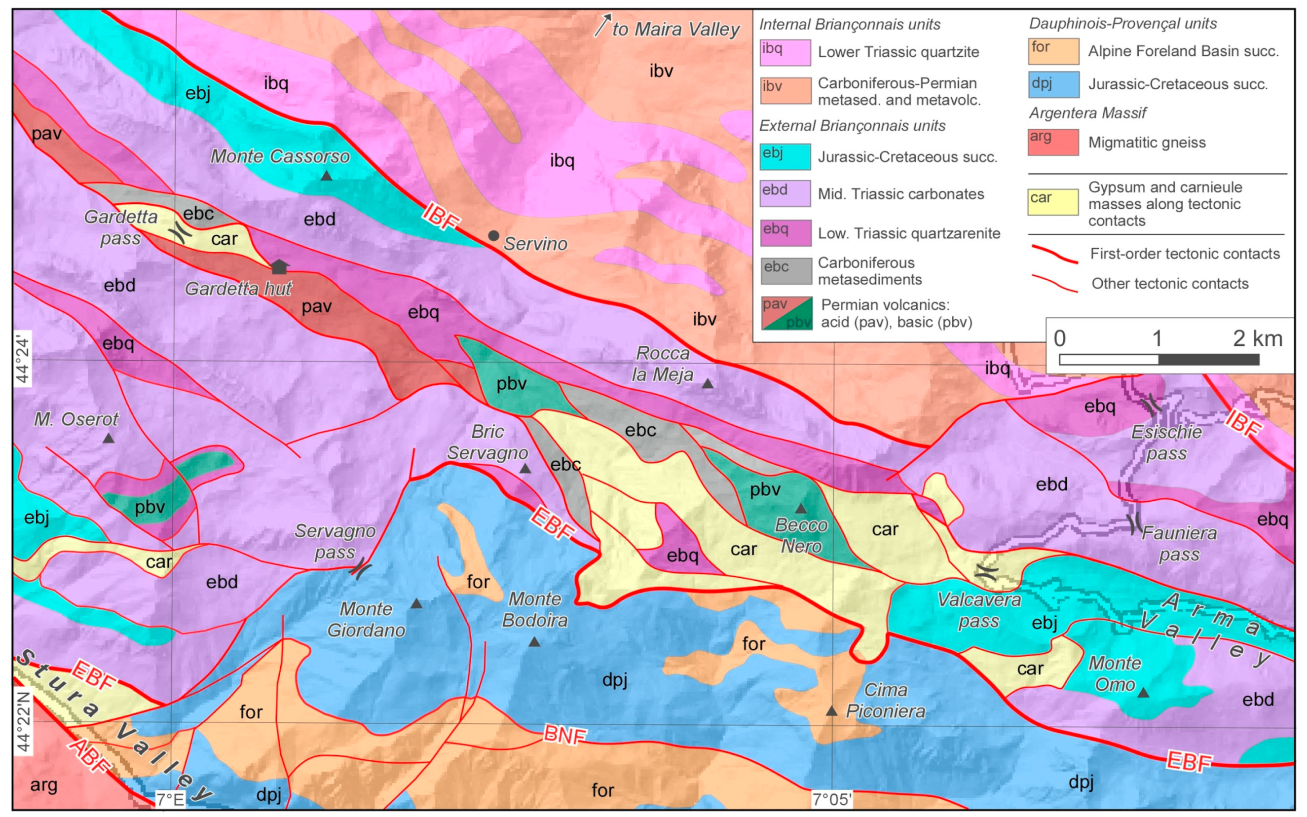
Figure 10. Geotectonic map of the Gardetta Deformation Zone, developed between the internal Briançonnais front (IBF) and the external Briançonnais front (EBF) (modified from [19]).
Geosciences 11 00185 g010
The structural setting of the SWAT/GVZ corresponds to a double-vergent tectonic system, mainly developed during the D1/D2/D3 phases, where NW-trending major folds, and both NE dipping and SW dipping reverse and strike slip faults developed. In the NW sectors [75,76,77], the NE-vergent (back-vergent) branch of the transect is indeed developed mostly inwards (NE) of the GVZ, in the internal Briançonnais units [21] (Figure 4). Conversely, in the SE sectors the NE-vergent fold systems are intensively developed within the GVZ itself [25,80,83], while the SW-vergent folds are less abundant, except near the tip zone of the SW-vergent thrusts (Figure 4). The presence of steepened slices of anhydrite and gypsum in the northern branch of the GVZ (Valcavera-Gardetta highland at the altitude of more than 2000 m), which have been found more to the East, at the northern termination of the LIVZ (not far from the IBF, at an altitude of less than 700 m, in the “Buzzi tunnel” between Roaschia and Robilante [104]) and, more extensively, along the Tenda Tunnel thrust at about 1000–1200 m a.s.l [23,86], suggests that the transpressive GVZ probably merged into the basal detachment of the external Briançonnais-Dauphinois-Provençal thrust belt from where it could have dragged, up to higher geometric positions, the above cited gypsum and anhydrite-bearing tectonic slices. The presence, within the fault core zone (namely in the restraining bends), of duplexes and slices extruded from deeper levels, is indirect evidence of transpressional fault setting [101,105,106]. The development of the GVZ unlikely occurred as the result 6tof an homogeneous transpression, as it shows a marked internal strain partitioning. Further analysis is required to ascertain if the strain partitioning was achieved mostly during the first deformation stage (D1) or continuously during the D1 to D3 stages.
(c)
As the SWAT activity was recorded by the tectonic evolution of the basement and covers (Mesozoic succession and Eocene-Oligocene Foreland Basin succession) at the southern termination of Western Alps, a third crucial point, concerning the sedimentary recordings of this tectonics in the syn-orogenic basins is to be discussed. The data reported in the above sections indicate that the exhumation/uplifting of the southern Cottian-Maritime-western Ligurian system occurred during the formation of the Alps-Apennines syn-orogenic basin known as TPB (Tertiary Piemonte Basin [9,19,74,107] with references therein). The TPB succession (Figure 1) was deposited starting from the early Oligocene on the exhuming metamorphic complexes of the Western Alps, as well as on the top of the overthrusting Ligurian units involved in the northwestern Apennines. The TPB successions recorded the Alps-Apennines tectonics through some regional scale unconformities related to main Geologic Events (Figure 11) that divided the succession into a number of unconformity-bounded stratigraphic units (Synthems [108]) continuous at the regional scale [19]. The analysis of a seismic line (Figure 9) available for the TPB sectors adjoining the Western Ligurian Alps [65], evidenced that the uplifting of the basement occurred during the depositions of the Oligocene-early Miocene succession, as evidence by late Chattian and Burdigalian reflectors that onlap distinct tectonic units, sealing the progressively younger activity of the faults branching from the main steep fault systems, interpreted by the authors as roughly E-W strike-slip faults deep-seated in the alpine basement. We suggest that this fault system could be consistent (as close to it and showing similar geometric and kinematic features) with the inferred eastward prolongation of the GVZ system (Figure 2), whose evidence in this sector of the western Ligurian Alps (i.e., the Limone-Viozene Zone [25,28]) has been confirmed by surface data. The activity of the GVZ/SWAT system thus occurred first during the early Oligocene sedimentation stages, when the basement of the TPB underwent a stretching, consistent with the sinistral transcurrent tectonics of the D1/D2 phase, which controlled the deposition of the lower Oligocene continental and coarse-grained marine sediment (Molare Fm. [99]), and induced an intense vertical mobility leading to a main regional denudation episode [109] and the onset of differentially subsiding sub-basins, bounded by high angle transtensional faults ([6,10] with references therein) and flanked by fastly uplifting areas. This stage was concomitant with the rifting phase of the Balearic basin [110] that in the internal part of the Ligurian Alps was less pronounced and rapidly decreased toward the North, maybe due to the hindering effect of the southern prolongation of the Ivrea high-density body [9]. The gradual decrease of the rifting was probably partitioned by the transpressive faults of the GVZ/SWAT system, as suggested by [10], during the D1/D2 phase.
All the early Oligocene sub-basins of the southern TPB then underwent, in late Rupelian and early Chattian times, a general drowning and subsidence, with the deposition of outer shelf and slope marly sediments (Rocchetta and Rigoroso Fms. [107]). This event occurred in a transtensional regime concomitant with crustal thinning and opening of back-arc basins [55] and was coeval with the initial stages of the Apennines dynamics, i.e., with the beginning of the Adriatic (Apennines) subduction [111].
Then, a marked inversion of southern TPB structures occurred during the Aquitanian-Early Burdigalian in response to an important geologic event induced by the change in the direction of motion of the Adriatic indenter with respect to Europe from NW-ward to WNW-ward at about 20 My [53,112,113]. This resulted in conditions of oblique convergence and increased collisional tectonics, whose effects are recorded in a large part of the western Mediterranean area and caused the switch from transtensional to contractional and transpressional regime in the southern TPB, inducing inversion of a great number of the formerly active structures [5,7,9,10,114,115,116]. In this period (early to middle Miocene) the TPB underwent a counterclockwise rotation of ca. 50° with respect to Africa [117].
In the southern western Alps, the Aquitanian-Burdigalian tectonic stage induced a marked regional uplift, with subsequent high denudation rates. This caused the eastward migration of fan-delta systems, prograding from the western margin of the TPB (the “Saluzzo-Monregalese belt” of [7]), accompanied by significant change in sediment composition [118]. In the western Ligurian Alps, the uplifting stage can be referred to the D3 phase, coeval with the main uplifting of the Argentera Massif [68,97] induced by dextral transpression along the northern boundary faults of the massif and D2/D3 back-thrusting. These thrusts are clearly sealed by the late Burdigalian reflectors reported in the line drawing of Figure 9.
The D2/D3 phase developed a penetrative regional foliation through large sectors of the Maritime and western Ligurian Alps: this foliation postdates the early Oligocene (see also [63]) and could be ascribed to compressional stages coeval and dynamically consistent with those recorded in the adjoining TPB successions, i.e., the main Apennines related tectonics that occurred at the Aquitanian-Burdigalian boundary, active while the Maritime and western Ligurian Alps continued their uplifting. The propagation of the N- and NE-vergent thrust front in the westernmost part of the Apennines was thus hindered by the uplifting Alpine basement and related covers. The E and NE-vergent transpressive faults propagating from the previously formed alpine belt also involved and stacked the Ligurian units resting on the Adria crust, as well as the same syn-orogenic sedimentary successions that were flanking the alpine units while they were uplifting [5,51,65]. It becomes clear now, in our view, that the NE-vergent contractional tectonic systems affecting the TPB can be defined alpine or Apennines-related depending on the substrate they displaced (alpine metamorphic units vs. Ligurian non-metamorphic units), but they developed indeed within the same geodynamic context since the late Oligocene, making it appropriate, for the westernmost Alpine-Padane realm, to refer to a single “Alps-Apennines orogenic system”, as in [19,74].
Figure 11. List of the Alpine Geologic events (D1–D5) recorded in the southern termination of Western Alps since Early Oligocene. The U1, U2…D7 unconformities correspond to the D1, D2…D7 regional unconformities of the TPB, as defined in [19,74]. The column “geodynamics” describes the relations with the main stages of the tectono-sedimentary evolution of the southern termination of the Western Alps and of north-western Apennines.
Geosciences 11 00185 g011

7. Conclusions

Based on a critical review of surface and subsurface geological data, integrated with new data and interpretations, it is concluded that the southern termination of the Western Alps arc recorded the Oligocene-Miocene activity of a regional transfer zone (the southwestern Alps Transfer, SWAT) whose existence has been often postulated in literature [15,34,81] and that should have allowed, since early Oligocene, the westward indentation of Adria and its counterclockwise rotation with respect to Europe. This “virtual” transfer zone, inferred on the basis of geodynamic constraints and reconstructions, could be partially seen, at shallow crustal level, in an effective system of deformation units and km-scale shear zones, here defined as the Gardetta-Viozene Zone (GVZ). The GVZ is developed externally to the internal Briançonnais Front (IBF), involving the external Briançonnais and Dauphinois-Provençal domains and the overlying Eocene-Oligocene sediments of the Alpine Foreland basin. The IBF, which represents the inner boundary of the SWAT, is thought to correspond to the Penninic Front, here intended as the frontal thrust which bounds the Alpine Axial Belt, i.e., the metamorphic orogenic prism (in the sense of [69]). Thus, in the southern termination of western Alps, the Penninic Front divides the external from the internal Briançonnais domains. Consequently, it can be argued that, in this area, the Briançonnais domain did not experience subduction and exhumation as a whole. The internal Briançonnais underwent major tectono-metamorphic transformations, while the external Briançonnais was subjected only to anchizonal P-T conditions. The relatively gradual transition (although stepwise across distinct tectonic fronts) from HP-LT metamorphism and very low-grade to anchizone metamorphism through the Briançonnais-Dauphinois transect of SW Alps, suggests a low entity of the thrust vertical offsets, as expected in an overall transpressive or strike-slip regional context.
The southwestern Alps Transfer acted outwardly of the IBF, in a foreland fold and thrust belt, consisting of the external Briançonnais and the Dauphinois-Provençal domains with related Alpine Foreland Basin successions, which was detached above quartzites and anhydrite-gypsum levels of inferred Triassic age, now locally involved in the core of the SWAT shear zones. Conversely, the IBF cut across the Triassic evaporite and quartzite level, bounding the external domains affected by “cover tectonics” from the internal levels, where the stacking involved the Permian metavolcanics and some levels of the underlying polymetamorphic basement [119,120]. The Oligocene to Miocene kinematic evolution of the above-described Alpine units was well recorded by the tectono-sedimentary evolution of the inner syn-orogenic basins, i.e., the so-called Tertiary Piemonte Basin, as evidenced by stratigraphic, sedimentological and geophysical data. This allows correlation with the Apennines kinematics and dynamics, in terms of the age of the main geologic events, the interference between the main structural systems and the tectonic control exerted by both the tectonic belts on the same syn-orogenic basin.

Author Contributions

Conceptualization, F.P.; investigation: A.d., L.B. and C.B.; data curation, F.P., A.d., L.B., C.B., A.I. and P.M.; writing—original draft preparation, F.P.; writing—review and editing, F.P., A.d., L.B., C.B., A.I. and P.M. All authors have read and agreed to the published version of the manuscript.

Funding

This research received no external funding.

Data Availability Statement

The study did not report any organised data sets.

Acknowledgments

Two anonymous reviewers are kindly thanked for their useful suggestions.

Conflicts of Interest

The authors declare no conflict of interest.

References

  1. Gelati, R.; Gnaccolini, M. Evoluzione tettonico-sedimentaria della zona limite tra Alpi ed Appennini tra l’inizio dell’Oligocene ed il Miocene medio. Mem. Soc. Geol. Ital. 1982, 2, 183–191. [Google Scholar]
  2. Mutti, E.; Papani, L.; di Biase, D.; Davoli, G.; Mora, S.; Segadelli, S.; Tinterri, R. Il Bacino Terziario Epimesoalpino e le sue implicazioni sui rapporti tra Alpi ed Appennino. Mem. Sci. Geol. 1995, 48, 233–291. [Google Scholar]
  3. Piana, F.; Polino, R. Tertiary structural relationships between Alps and Apennines: The critical Torino Hill and Monferrato area. Northwestern Italy. Terra Nova 1995, 7, 138–143. [Google Scholar] [CrossRef]
  4. Biella, G.C.; Polino, R.; de Franco, R.; Rossi, P.M.; Clari, P.; Corsi, A.; Gelati, R. The crustal structure of the western Po plain: Reconstruction from integrated geological and seismic data. Terra Nova 1997, 9, 28–31. [Google Scholar] [CrossRef]
  5. Piana, F. Structural setting of western Monferrato (Alps-Apennines junction zone, NW Italy). Tectonics 2000, 19, 943–960. [Google Scholar] [CrossRef]
  6. Mutti, E.; di Biase, D.; Fava, L.; Mavilla, N.; Sgavetti, M.; Tinterri, R. The Tertiary Piemonte Basin. In Revisiting Turbidites of the Marnoso-Arenacea Formation and their Basin-Margin Equivalents: Problems with Classic Models; Mutti, E., Ricci Lucchi, F., Roveri, M., Eds.; Excursion Notes-Part II. Excursion Guidebook of “Turbidite Workshop”; Dipartimento di Scienze della Terra, Università di Parma, ENI Spa: Parma, Italy, 2002; p. 25. [Google Scholar]
  7. Rossi, M.; Mosca, P.; Polino, R.; Rogledi, S.; Biffi, U. New outcrop and subsurface data in the Tertiary Piedmont Basin (NW Italy): Unconformity-bounded stratigraphic units and their relationships with basin modification phases. Riv. Ital. Paleontol. Stratigr. 2009, 115, 305–335. [Google Scholar]
  8. Ghielmi, M.; Minervini, M.; Nini, C.; Rogledi, S.; Rossi, M. Late Miocene-Middle Pleistocene sequences in the Po Plain—Northern Adriatic Sea (Italy): The stratigraphic record of modification phases affecting a complex foreland basin. Marine Petrol. Geol. 2013, 42, 50–81. [Google Scholar] [CrossRef]
  9. Maino, M.; Decarlis, A.; Felletti, F.; Seno, S. Tectono-sedimentary evolution of the Tertiary Piedmont Basin (NW Italy) within the Oligo-Miocene central Mediterranean geodynamics. Tectonics 2013, 32, 593–619. [Google Scholar] [CrossRef]
  10. Ghibaudo, G.; Massari, F.; Chiambretti, I.; d’Atri, A.; Fornaciari, E. Birth and tectono-sedimentary evolution of the Tertiary Piedmont Basin (NW Italy). J. Medit. Earth Sci. 2019, 11, 5–112. [Google Scholar] [CrossRef]
  11. Doglioni, C.; Mongelli, F.; Pialli, G.P. Boudinage of the Alpine belt in the Apenninic back-arc. Mem. Soc. Geol. It. 1998, 52, 457–468. [Google Scholar]
  12. Doglioni, C.; Gueguen, E.; Harabaglia, P.; Mongelli, F.C. On the origin of west-directed subduction zones and applications to the western Mediterranean. Geol. Soc. Lond. Spec. Publ. 1999, 156, 541–561. [Google Scholar] [CrossRef]
  13. Brunet, C.; Monié, P.; Jolivet, L.; Cadet, J.P. Migration of compression and extension in the Tyrrhenian Sea, insights from 40Ar/39Ar ages on micas along a transect from Corsica to Tuscany. Tectonophysics 2000, 321, 127–155. [Google Scholar] [CrossRef]
  14. Carminati, E.; Doglioni, C. Europe—Mediterranean tectonics. In Encyclopedia of Geology; Selley, R., Cocks, R., Plimer, J., Eds.; Elsevier: Oxford, UK, 2004; pp. 135–146. [Google Scholar]
  15. Ford, M.; Duchene, S.; Gasquet, D.; Vanderhaeghe, O. Two-phase orogenic convergence in the external and internal SW Alps. J. Geol. Soc. 2006, 163, 815–826. [Google Scholar] [CrossRef]
  16. Lardeaux, J.M.; Schwartz, S.; Tricart, P.; Paul, A.; Guillot, S.; Béthoux, N.; Masson, F. A crustal-scale cross-section of the south-western Alps combining geophysical and geological imagery. Terra Nova 2006, 18, 412–422. [Google Scholar] [CrossRef]
  17. Schreiber, D.; Lardeaux, J.-M.; Martelet, G.; Courrioux, G.; Guillen, A. 3-D modelling of Alpine Mohos in Southwestern Alps. Geoph. J. Intern. 2010, 180, 961–975. [Google Scholar] [CrossRef]
  18. Daniel, J.M.; Jolivet, L.; Goffe, B.; Poinssot, C. Crustal-scale strain partitioning: Footwall deformation below the Alpine Oligo-Miocene detachment of Corsica. J. Struct. Geol. 1996, 18, 41–59. [Google Scholar] [CrossRef]
  19. Piana, F.; Fioraso, G.; Irace, A.; Mosca, P.; d’Atri, A.; Barale, L.; Falletti, P.; Monegato, G.; Morelli, M.; Tallone, S.; et al. Geology of Piemonte region (NW Italy, Alps–Apennines interference zone). J. Maps 2017, 13, 395–405. [Google Scholar] [CrossRef]
  20. Gidon, M. Les chaînons briançonnais et subbriançonnais de la rive gauche de la Stura entre Bersezio et le Val de l’Arma (province de Cuneo Italie). Géol. Alpine 1972, 48, 87–120. [Google Scholar]
  21. Michard, A.; Avigad, D.; Goffé, B.; Chopin, C. The high-pressure metamorphic front of the south Western Alps (Ubaye-Maira transect, France, Italy). Schweiz. Min. Petr. Mitt. 2004, 84, 215–235. [Google Scholar]
  22. Malaroda, R.; Carraro, F.; Dal Piaz, G.; Franceschetti, B.; Sturani, C.; Zanella, E. Note illustrative della Carta Geologica del Massiccio dell’Argentera alla scala 1: 50.000. Mem. Soc. Geol. Ital. 1970, 9, 557–663. [Google Scholar]
  23. D’Atri, A.; Piana, F.; Barale, L.; Bertok, C.; Martire, L. Geological setting of the southern termination of Western Alps. Int. J. Earth Sci. 2016, 105, 1831–1858. [Google Scholar] [CrossRef]
  24. Mohn, G.; Manatschal, G.; Beltrando, M.; Masini, E.; Kusznir, N. Necking of continental crust in magma-poor rifted margins: Evidence from the fossil Alpine Tethys margins. Tectonics 2012, 31, TC1012. [Google Scholar] [CrossRef]
  25. Piana, F.; Musso, A.; Bertok, C.; d’Atri, A.; Martire, L.; Perotti, E.; Varrone, D.; Martinotti, G. New data on post-Eocene tectonic evolution of the External Ligurian Brianconnais (Western Ligurian Alps). Boll. Soc. Geol. Ital. 2009, 128, 353–366. [Google Scholar]
  26. Piana, F.; Battaglia, S.; Bertok, C.; d’Atri, A.; Ellero, A.; Leoni, L.; Martire, L.; Perotti, E. Illite (KI) and chlorite (AI) “crystallinity” indices as a constraint for the evolution of the External Briançonnais Front in Western Ligurian Alps (NW Italy). Ital. J. Geosci. 2014, 133, 445–454. [Google Scholar] [CrossRef]
  27. Barale, L.; Bertok, C.; d’Atri, A.; Martire, L.; Piana, F.; Domini, G. Geology of the Entracque–Colle di Tenda area (Maritime Alps, NW Italy). J. Maps 2016, 12, 359–370. [Google Scholar] [CrossRef] [Green Version]
  28. Bertok, C.; Musso, A.; D’Atri, A.; Martire, L.; Piana, F. Geology of the Colle di Tenda—Monte Marguareis area (Ligurian Alps, NW Italy). J. Maps 2018, 14, 542–551. [Google Scholar] [CrossRef] [Green Version]
  29. Mueller, P.; Maino, M.; Seno, S. Progressive Deformation Patterns from an Accretionary Prism (Helminthoid Flysch, Ligurian Alps, Italy). Geosciences 2020, 10, 26. [Google Scholar] [CrossRef] [Green Version]
  30. Sagri, M. Le Arenarie di Bordighera: Una conoide sottomarina nel bacino di sedimentazione del Flysch a Elmintoidi di San Remo (Cretaceo superiore, Liguria Occidentale). Boll. Soc. Geol. Ital. 1980, 98, 205–226. [Google Scholar]
  31. Sagri, M. Litologia, stratimetria e sedimentologia delle torbiditi di piana di bacino del flysch di San Remo (Cretaceo superiore, Liguria occidentale). Mem. Soc. Geol. Ital. 1984, 28, 577–586. [Google Scholar]
  32. Vanossi, M. Les unités géologiques des Alpes Maritimes entre l’Ellero et la Mèr Ligure: Un aperçu schématique. Mem. Ist. Geol. Mineral. Univ. Padova 1980, 3, 101–142. [Google Scholar]
  33. Kerckhove, C. La “zone du flysch” dans les nappes de l’Embrunais-Ubaye (Alpes occidentales). Géol. Alpine 1969, 45, 5–204. [Google Scholar]
  34. Dumont, T.; Schwartz, S.; Guillot, S.; Simon-Labric, T.; Tricart, P.; Jourdan, S. Structural and sedimentary records of the Oligocene revolution in the Western Alpine arc. J. Geodyn. 2012, 56, 18–38. [Google Scholar] [CrossRef] [Green Version]
  35. Lanteaume, M. Contribution à l’étude Géologique des Alpes Maritimes Franco-Italiennes; Carte Géologique de France, Imprimerie Nationale: Paris, France, 1968; pp. 1–405. [Google Scholar]
  36. Di Giulio, A. The evolution of the Western Ligurian Flysch Units and the role of mud diapirism in ancient accretionary prisms (Maritime Alps, Northwestern Italy). Int. J. Earth Sci. 1992, 81, 655–668. [Google Scholar] [CrossRef]
  37. Seno, S.; Dallagiovanna, G.; Vanossi, M. A kinematic evolutionary model for the Penninic sector of the central Ligurian Alps. Int. J. Earth Sci. 2005, 94, 114–129. [Google Scholar] [CrossRef]
  38. Lavier, L.; Manatschal, G. A mechanism to thin the continental lithosphere at magma-poor margins. Nature 2006, 440, 324–328. [Google Scholar] [CrossRef]
  39. Decarlis, A.; Manatschal, G.; Haupert, I.; Masini, E. The tectono-stratigraphic evolution of distal, hyper-extended magma-poor conjugate rifted margins: Examples from the Alpine Tethys and Newfoundland-Iberia. Mar. Petr. Geol. 2015, 68, 54–72. [Google Scholar] [CrossRef]
  40. Decarlis, A.; Lualdi, A. Late Triassic-early Jurassic paleokarst from the Ligurian Alps and its geological significance (Siderolitico Auct., Ligurian Briançonnais domain). Swiss J. Geosci. 2008, 101, 579–593. [Google Scholar] [CrossRef]
  41. Lemoine, M.; Bas, T.; Arnaud-Vanneau, A.; Arnaud, H.; Dumont, T.; Gidon, M.; Bourbon, M.; de Graciansky, P.-C.; Rudkiewicz, J.L.; Megard-Galli, J.; et al. The continental margin of the Mesozoic Tethys in the Western Alps. Mar. Petrol. Geol. 1986, 3, 179–199. [Google Scholar] [CrossRef]
  42. Claudel, M.E.; Dumont, T. A record of multistage continental break-up on the Briançonnais marginal plateau (Western Alps): Early and middle−late Jurassic rifting. Eclogae Geol. Hel. 1999, 92, 45–61. [Google Scholar]
  43. Debelmas, J.; Kerckhove, C. II: Les Alpes franco-italiennes. In: France: Introduction à la géologie du Sud-Est. Géol. Alpine 1980, 56, 282. [Google Scholar]
  44. Mohn, G.; Manatschal, G.; Müntener, O.; Beltrando, M.; Masini, E. Unravelling the interaction between tectonic and sedimentary processes during lithospheric thinning in the Alpine Tethys margins. Int. J. Earth Sci. 2010, 99, 75–101. [Google Scholar] [CrossRef]
  45. Faure-Mauret, A. Études Géologiques sur le Massif de l’Argentera-Mercantour et ses Enveloppes Sédimentaires; Mémoires. Carte Géologique: Paris, France, 1955; p. 336. [Google Scholar]
  46. Barale, L.; Bertok, C.; d’Atri, A.; Martire, L.; Piana, F. Stratigraphy, sedimentology and syndepositional tectonics of the Jurassic–Cretaceous succession at the transition between Provençal and Dauphinois domains (Maritime Alps, NW Italy). Riv. Ital. Paleont. Strat. 2017, 123, 355–378. [Google Scholar]
  47. Malaroda, R. Carta Geologica del Massiccio dell’Argentera alla scala 1: 50.000. Mem. Soc. Geol. Ital. 1970, 9, 557–663. [Google Scholar]
  48. Bersezio, R.; Barbieri, P.; Mozzi, R. Redeposited limestones in the Upper Cretaceous succession of the Helvetic Argentera Massif at the Italy–France border. Eclogae Geol. Helv. 2002, 95, 15–30. [Google Scholar]
  49. Sinclair, H.D. Tectono–stratigraphic model for underfilled peripheral foreland basins: An Alpine perspective. GSA Bull. 1997, 109, 324–346. [Google Scholar] [CrossRef]
  50. Apps, G.; Peel, F.; Elliott, T. The structural setting and palaeogeographical evolution of the Grès d’Annot Basin. Geol. Soc. London Spec. Publ. 2004, 221, 65–96. [Google Scholar] [CrossRef]
  51. Molli, G.; Crispini, L.; Malusà, M.G.; Mosca, P.; Piana, F.; Federico, L. Geology of the Western Alps-Northern Apennine junction area: A regional review. J. Virt. Expl. 2010, 36, 1–48. [Google Scholar] [CrossRef]
  52. Bertok, C.; Martire, L.; Perotti, E.; d’Atri, A.; Piana, F. Kilometre-scale palaeoescarpments as evidence for Cretaceous synsedimentary tectonics in the External Briançonnais Domain (Ligurian Alps, Italy). Sedim. Geol. 2012, 251, 58–75. [Google Scholar] [CrossRef]
  53. Handy, M.R.; Schmid, S.M.; Bousquet, R.; Kissling, E.; Bernoulli, D. Reconciling plate-tectonic reconstructions of Alpine Tethys with the geological–geophysical record of spreading and subduction in the Alps. Earth Sci. Rev. 2010, 102, 121–158. [Google Scholar] [CrossRef]
  54. Dumont, T.; Simon-Labric, T.; Authemayou, C.; Heymes, T. Lateral termination of the north-directed Alpine orogeny and onset of westward escape in the Western Alpine arc: Structural and sedimentary evidence from the external zone. Tectonics 2011, 30, TC5006. [Google Scholar] [CrossRef] [Green Version]
  55. Vignaroli, G.; Rossetti, F.; Rubatto, D.; Theye, T.; Lisker, F.; Phillips, D. Pressure-temperature- deformation-time (P-T-d-t) exhumation history of the Voltri Massif HP complex, Ligurian Alps, Italy. Tectonics 2010, 29, TC6009. [Google Scholar] [CrossRef] [Green Version]
  56. Laubscher, H. The arc of the Western Alps today. Eclogae Geol. Helv. 1991, 84, 631–659. [Google Scholar]
  57. Tavani, S.; Bertok, C.; Granado, P.; Piana, F.; Salas, R.; Vigna, B.; Muñoz, J.A. The Iberia-Eurasia plate boundary east of the Pyrenees. Earth Sci. Rev. 2018, 187, 314–337. [Google Scholar] [CrossRef]
  58. Vignaroli, G.; Faccenna, C.; Jolivet, L.; Piromallo, C.; Rossetti, F. Subduction polarity reversal at the junction between the Western Alps and the Northern Apennines, Italy. Tectonophysics 2008, 450, 34–50. [Google Scholar] [CrossRef]
  59. Bertok, C.; Martire, L.; Perotti, E.; d’Atri, A.; Piana, F. Middle-Late Jurassic syndepositional tectonics recorded in the Ligurian Briançonnais succession (Marguareis–Mongioie area, Ligurian Alps, NW Italy). Swiss J. Geosci. 2011, 104, 237–255. [Google Scholar] [CrossRef]
  60. Perotti, E.; Bertok, C.; d’Atri, A.; Martire, L.; Piana, F.; Catanzariti, R. A tectonically-induced Eocene sedimentary mélange in the West Ligurian Alps, Italy. Tectonophysics 2012, 568, 200–214. [Google Scholar] [CrossRef]
  61. Barale, L.; Bertok, C.; d’Atri, A.; Domini, G.; Martire, L.; Piana, F. Hydrothermal dolomitization of the carbonate Jurassic succession in the Provençal and Subbriançonnais Domains (Maritime Alps, North-Western Italy). Compt. Rend. Geosci. 2013, 345, 47–53. [Google Scholar] [CrossRef]
  62. Barale, L.; Bertok, C.; Salih Talabani, N.; d’Atri, A.; Martire, L.; Piana, F.; Préat, A. Very hot, very shallow hydrothermal dolomitization: An example from the Maritime Alps (north-west Italy-south-east France). Sedimentology 2016, 63, 2037–2065. [Google Scholar] [CrossRef]
  63. Bertok, C.; Barale, L.; d’Atri, A.; Martire, L.; Piana, F.; Rossetti, P.; Gerdes, A. Unusual marbles in a non-metamorphic succession of the SW Alps (Valdieri, Italy) due to early Oligocene hydrothermal flow. Int. J. Earth Sci. 2019, 108, 693–712. [Google Scholar] [CrossRef]
  64. Larroque, C.; Delouis, B.; Godel, B.; Nocquet, J.-M. Active deformation at the southwestern Alps–Ligurian basin junction (France–Italy boundary): Evidence for recent change from compression to extension in the Argentera massif. Tectonophysics 2009, 467, 22–34. [Google Scholar] [CrossRef]
  65. Mosca, P.; Polino, R.; Rogledi, S.; Rossi, M. New data for the kinematic interpretation of the Alps–Apennines junction (Northwestern Italy). Int. J. Earth Sci. 2009, 99, 833–849. [Google Scholar] [CrossRef]
  66. Goffe, B.; Schwartz, S.; Lardeaux, J.-M.; Bousquet, R. Explanatory notes to the map: Metamorphic structure of the Alps western and Ligurian Alps. Mitt. Österr. Miner. Ges. 2004, 149, 125–144. [Google Scholar]
  67. Bigot-Cormier, F.; Sosson, M.; Poupeau, G.; Stéphan, J.-F.; Labrin, E. The denudation history of the Argentera Alpine External Crystalline Massif (Western Alps, France-Italy): An overview from the analysis of fission tracks in apatites and zircons. Geodin. Acta 2006, 19, 455–473. [Google Scholar] [CrossRef]
  68. Sanchez, G.; Rolland, Y.; Jolivet, M.; Brichau, S. Exhumation controlled by transcurrent tectonics: The Argentera–Mercantour massif (SW Alps). Terra Nova 2011, 23, 116–126. [Google Scholar] [CrossRef]
  69. Beltrando, M.; Compagnoni, R.; Lombardo, B. (Ultra-) High-pressure metamorphism and orogenesis: An Alpine perspective. Gond. Res. 2010, 18, 147–166. [Google Scholar] [CrossRef]
  70. Herwegh, M.; Berger, A.; Baumberger, R.; Wehrens, P.; Kissling, E. Large-Scale Crustal-Block-Extrusion during Late Alpine Collision. Sci. Rep. 2017, 7, 413. [Google Scholar] [CrossRef] [Green Version]
  71. Dal Piaz, G.V.; Bistacchi, A.; Massironi, M. Geological outline of the Alps. Episodes 2003, 26, 175–180. [Google Scholar] [CrossRef] [Green Version]
  72. Ford, M.; Lickorish, W.; Kusznir, N. Tertiary foreland sedimentation in the Southern Subalpine Chains, SE France: A geodynamic appraisal. Basin Res. 1999, 11, 315–336. [Google Scholar] [CrossRef]
  73. Tricart, P. From extension to transpression during the final exhumation of the Pelvoux and Argentera massifs, Western Alps. Eclogae Geol. Helv. 2004, 97, 429–439. [Google Scholar] [CrossRef]
  74. Piana, F.; Barale, L.; Compagnoni, R.; d’Atri, A.; Fioraso, G.; Irace, A.; Mosca, P.; Tallone, S.; Morelli, M. Geological map of Piemonte region at 1:250,000 scale. Explanatory Notes. Acc. Sc. Torino Mem. Sc. Fis. 2017, 41, 1–143. [Google Scholar]
  75. Debelmas, J.; Lemoine, M. Carte Géologique de France au 1/50 000, Feuille Guillestre. Notice Explicative; Bureau. Recherchés. Géologique. Miniéres: Orléans, France, 1965; p. 20.
  76. Tricart, P. Les rétrocharriages dans les Alpes franco-italiennes. Évolution des structures sur la transversale Embrunais-Queyras (Hautes-Alpes). Sci. Géol. Bull. Strasbourg 1975, 28, 239–259. [Google Scholar] [CrossRef]
  77. Tricart, P. From passive margin to continental collision: A tectonic scenario for the Western Alps. Am. J. Sci. 1984, 284, 97–120. [Google Scholar] [CrossRef]
  78. Caby, R. Low-angle extrusion of high-pressure rocks and the balance between outward and inward displacements of Middle Penninic units in the Western Alps. Eclogae Geol. Helv. 1996, 89, 229–267. [Google Scholar]
  79. Bucher, S.; Schmid, S.M.; Bousquet, R.; Fügenschuh, B. Late-stage deformation in a collisional orogen (Western Alps): Nappe refolding, back-thrusting or normal faulting? Terra Nova 2003, 15, 109–117. [Google Scholar] [CrossRef] [Green Version]
  80. Vanossi, M.; Cortesogno, L.; Galbiati, B.; Messiga, B.; Piccardo, G.; Vanucci, R. Geologia delle Alpi Liguri: Dati, problemi, ipotesi. Mem. Soc. Geol. Ital. 1984, 28, 5–75. [Google Scholar]
  81. Giglia, G.; Capponi, G.; Crispini, L.; Piazza, M. Dynamics and seismotectonics of the West-Alpine arc. Tectonophysics 1996, 267, 143–146. [Google Scholar] [CrossRef]
  82. Petti, F.M.; Furrer, H.; Collo, E.; Martinetto, E.; Bernardi, M.; Delfino, M.; Romano, M.; Piazza, M. Archosauriform footprints in the Lower Triassic of Western Alps and their role in understanding the effects of the Permian-Triassic hyperthermal. PeerJ 2020, 8, e10522. [Google Scholar] [CrossRef]
  83. Carminati, E.; Gosso, G. Structural map of a Ligurian Briançon- nais cover nappe (Conca delle Carsene, Monte Marguareis, Ligurian Alps, Italy) and explanatory notes. Mem. Sci. Geol. 2000, 52, 93–99. [Google Scholar]
  84. Simon-Labric, T.; Rolland, Y.; Dumont, T.; Heymes, T.; Authemayou, C.; Corsini, M.; Fornari, M. 40Ar/39Ar dating of Penninic Front tectonic displacement (W Alps) during the Lower Oligocene (31–34 Ma). Terra Nova 2009, 21, 127–136. [Google Scholar] [CrossRef]
  85. Baldacci, L.; Franchi, S. Studio geologico della galleria del Colle di Tenda: (linea Cuneo–Ventimiglia). Boll. R. Com. Geol. Ital. 1900, 31, 33–87. [Google Scholar]
  86. Cavinato, G.P.; Di Luzio, E.; Moscatelli, M.; Vallone, R.; Averardi, M.; Valente, A.; Papale, S. The new Col di Tenda tunnel between Italy and France: Integrated geological investigations and geophysical prospections for preliminary studies on the Italian side. Engen. Geol. 2006, 88, 90–109. [Google Scholar] [CrossRef]
  87. Brizio, F.D.; Deregibus, C.; Eusebio, A.; Gallo, M.; Gosso, G.; Rattalino, E.; Rossi, F.; Tosetto, S.; Oxilia, M. Guida all’escursione: I rapporti tra la zona Brianzonese Ligure e il Flysch a Elmintoidi, Massiccio del Marguareis (Limone Piemonte-Certosa di Pesio, Cuneo, 14/15 Settembre 1983). Mem. Soc. Geol. Ital. 1983, 26, 579–595. [Google Scholar]
  88. Lefèvre, R. La cicatrice de Preit: Une discontinuité structurale majeure au sein de la zone briançonnaise entre Acceglio et l’Argentera (Alpes Cottiennes méridionales). C. R. Acad. Sci. Paris 1983, 296, 1551–1554. [Google Scholar]
  89. Malaroda, R. Il Flysch di Demonte-Aisone e il sondaggio di Aisone. Acc. Sc. Torino Atti Sc. Fis. 2000, 24, 1–37. [Google Scholar]
  90. Beucher, R.; Sue, C.; Tricart, P. Orogen-parallel brittle extension as a major tectonic imprint in the Neogene evolution of the south-western Alpine arc. Int. J. Earth Sci. 2017, 106, 2973–2990. [Google Scholar] [CrossRef]
  91. Lefèvre, R.; Michard, A. Les nappes briançonnaises internes et ultra-briançonnaises de la bande d’Acceglio (Alpes franco-italiennes); une étude structurale et pétrographique dans le faciès des schistes bleus à jadéite. Sci. Géol. Bull. 1976, 29, 183–222. [Google Scholar] [CrossRef]
  92. Monié, P. Preservation of Hercynian 40Ar/39Ar ages through high-presssure low-temperature Alpine metamorphism in the Western Alps. Eur. J. Mineral. 1990, 2, 343–361. [Google Scholar] [CrossRef]
  93. Du Fornel, E.; Joseph, P.; Desaubliaux, G.; Eschard, R.; Guillocheau, F.; Lerat, O.; Muller, C.; Ravenne, C.; Sztràkos, K. The southern Grès d’Annot outcrops (French Alps): An attempt at regional correlation. Geol. Soc. Lond. Spec. Publ. 2004, 221, 137–160. [Google Scholar] [CrossRef]
  94. Yin, A. Cenozoic tectonic evolution of the Himalayan orogen as constrained by along-strike variation of structural geometry, exhumation history, and foreland sedimentation. Earth Sci. Rev. 2006, 76, 1–131. [Google Scholar] [CrossRef]
  95. Barale, L.; Bertok, C.; d’Atri, A.; Martire, L.; Piana, F.; Bernasconi, S.M.; Birgel, D.; Czuppon, G.; Gerdes, A. U/Pb dating and geochemical constraints to hydrothermal dolomitization in the Provençal Domain (Maritime Alps): Implications for Early Cretaceous tectonics. Ofioliti 2021. accepted for publication. [Google Scholar]
  96. Baietto, A.; Cadoppi, P.; Martinotti, G.; Perello, P.; Perrochet, P.; Vuataz, F.D. Assessment of thermal circulations in strike-slip fault systems: The Terme di Valdieri case (Italian Western Alps). Geol. Soc. Lond. Spec. Publ. 2008, 299, 317–339. [Google Scholar] [CrossRef]
  97. Sanchez, G.; Rolland, Y.; Schneider, J.; Corsini, M.; Oliot, E.; Goncalves, P.; Verati, C.; Lardeaux, J.-M.; Marquer, D. Dating low-temperature deformation by 40Ar/39Ar on white mica, insights from the Argentera-Mercantour Massif (SW Alps). Lithos 2011, 125, 521–536. [Google Scholar] [CrossRef]
  98. Bauve, V.; Plateaux, R.; Rolland, Y.; Sanchez, G.; Bethoux, N.; Delouis, B.; Darnault, R. Long-lasting transcurrent tectonics in SW Alps evidenced by Neogene to present-day stress fields. Tectonophysics 2014, 621, 85–100. [Google Scholar] [CrossRef]
  99. Lorenz, C. Evolution stratigraphique et structurale des Alpes Ligures depuis l’Eocène supérieur. Boll. Soc. Geol. Ital. 1984, 28, 211–228. [Google Scholar]
  100. Casnedi, R.; Mosna, S. Segnalazione di una serie miocenica inferiore nel Monregalese (Bacino Terziario Piemontese). Acc. Naz. Lincei Cl. Sc. Fis. Mat. Nat. 1970, 48, 146–155. [Google Scholar]
  101. Dewey, J.F.; Holdsworth, R.E.; Strachan, R.A. Transpression and transtension zones. Geol. Soc. Lond. Spec. Publ. 1998, 135, 1–14. [Google Scholar] [CrossRef]
  102. Jones, R.; Tunner, P.V.G. Strain partitioning in transpression zones. J. Struct. Geol. 1995, 17, 793–802. [Google Scholar] [CrossRef]
  103. Jones, R.; Holdsworth, R.; Clegg, P.; McCaffrey, K.; Tavarnelli, E. Inclined transpression. J. Struct. Geol. 2004, 26, 1531–1548. [Google Scholar] [CrossRef]
  104. Minoja, M. Bene Comune e Comportamenti Responsabili. Storie di Imprese e di Istituzioni; EGEA: Milano, Italy, 2015; p. 410. ISBN 9788823814035. [Google Scholar]
  105. Woodcock, N.H.; Rickards, B. Transpressive duplex and flower structure: Dent Fault System, NW England. J. Struct. Geol. 2003, 25, 1981–1992. [Google Scholar] [CrossRef]
  106. Cunningham, W.D.; Mann, P. Tectonics of strike-slip restraining and releasing bends. Geol. Soc. Lond. Spec. Publ. 2007, 290, 1–12. [Google Scholar] [CrossRef] [Green Version]
  107. Gelati, R.; Gnaccolini, M. Synsedimentary tectonic and sedimentation in the Tertiary Piedmont Basin, northwestern Italy. Riv. Ital. Paleont. Strat. 1998, 104, 193–214. [Google Scholar]
  108. Chang, K.H. Unconformity bounded stratigraphic units. Geol. Soc. Am. Bull. 1975, 86, 1544–1552. [Google Scholar] [CrossRef]
  109. Bertotti, G.; Mosca, P.; Juez, J.; Polino, R.; Dunai, T. Oligocene to Present kilometres scale subsidence and exhumation of the Ligurian Alps and the Tertiary Piedmont Basin (NW Italy) revealed by apatite (U-Th)/He thermochronology: Correlation with regional tectonics. Terra Nova 2006, 18, 18–25. [Google Scholar] [CrossRef]
  110. Réhault, J.P.; Boillot, G.; Mauffret, A. The western Mediterranean basin geological evolution. Mar. Geol. 1984, 55, 447. [Google Scholar]
  111. Jolivet, L.; Faccenna, C. Mediterranean extension and the Africa-Eurasia collision. Tectonics 2000, 19, 1095–1106. [Google Scholar] [CrossRef]
  112. Edel, J.B.; Dubois, D.; Marchant, R.; Hernandez, J.; Cosca, M. La rotation miocène inférieur du bloc corso-sarde; nouvelles contraintes paléomagnétiques sur la fin du mouvement. Bull. Soc. Géol. France 2001, 172, 275–283. [Google Scholar] [CrossRef]
  113. Schmid, S.M.; Kissling, E. The arc of the Western Alps in the light of geophysical data on deep crustal structure. Tectonics 2000, 19, 62–85. [Google Scholar] [CrossRef]
  114. Falletti, P.; Gelati, R.; Rogledi, S. Oligo-Miocene evolution of Monferrato and Langhe, related to deep structures. In Atti del Convegno “Rapporti Alpi-Appennino” e Guide alle Escursioni; Peveragno (CN) 31 Maggio–1 Giugno 1994; Polino, R., Sacchi, R., Eds.; Accademia Nazionale delleScienze: Verona, Italy, 1995; Volume 14, pp. 1–19. [Google Scholar]
  115. Festa, A.; Piana, F.; Dela Pierre, F.; Malusà, M.G.; Mosca, P.; Polino, R. Oligocene-Neogene kinematic constraints in the retroforeland basin of the northwestern Alps. Rend. Soc. Geol. Ital. 2005, 1, 107–108. [Google Scholar]
  116. Piana, F.; Tallone, S.; Cavagna, S.; Conti, A. Thrusting and faulting in metamorphic and sedimentary units of Ligurian Alps: An example of integrated field work and geochemical analyses. Int. J. Earth Sci. 2006, 95, 413–430. [Google Scholar] [CrossRef]
  117. Maffione, M.; Speranza, F.; Faccenna, C.; Cascella, A.; Vignaroli, G.; Sagnotti, L. A synchronous Alpine and Corsica-Sardinia rotation. J. Geophys. Res. 2008, 113, 10–25. [Google Scholar] [CrossRef]
  118. Carrapa, B.; Bertotti, G.; Krijgsman, W. Subsidence, stress regime and rotation (s) of a tectonically active sedimentary basin within the western Alpine Orogen: The Tertiary Piedmont Basin (Alpine domain, NW Italy). Geol. Soc. Lond. Spec. Publ. 2003, 208, 205–227. [Google Scholar] [CrossRef] [Green Version]
  119. Lefèvre, R. La structure et le style tectonique de la bande d’Acceglio en Val Maira (Alpes cottiennes italiennes). Géol. Alpine 1968, 44, 27–36. [Google Scholar]
  120. Schwartz, S.; Lardeaux, J.M.; Tricart, P. La zone d’Acceglio (Alpes Cottiennes): Un nouvel exemple de croûte continentale éclogitisée dans les Alpes occidentales. C. R. Acad. Sci. 2000, 330, 859–866. [Google Scholar] [CrossRef]
Publisher’s Note: MDPI stays neutral with regard to jurisdictional claims in published maps and institutional affiliations.