Review

The Shape of Fluvial Gravels: Insights from Fiji’s Sabeto River

Department of Archaeology, The University of Sydney, Sydney, New South Wales 2006, Australia
Geosciences 2021, 11(4), 161; https://doi.org/10.3390/geosciences11040161
Submission received: 4 March 2021 / Revised: 25 March 2021 / Accepted: 26 March 2021 / Published: 1 April 2021
(This article belongs to the Special Issue The Geoscience of the Pacific Islands Region: Theory and Practice)

Abstract

:
This project aims to re-assess our understanding of the shape of fluvial bedload gravels by drawing together existing information on fluvial gravel shape. At its crux, however, is the interpretation of a large, high-quality set of measurements made on bedload gravels from the Sabeto River of western Viti Levu, Fiji. This work reveals that the apparent simplicity displayed by most studies of downstream rounding disguises a complex pattern of stepwise reversals to an angular state, the result of the splitting of cobble- and boulder-sized particles. Particle sphericity changes rapidly during the initial stages of transport. Along the Sabeto, this seems to be the result of attrition, with breakage generating the low and continuing presence of low sphericity particles in the system. Elsewhere, however, sphericity is a consequence of shape sorting and we speculate that rivers globally exist along a sorting–attrition continuum. The form of fluvial gravels is not what would be expected were sorting the dominant control on gravel form. Instead measurements of form display a complex relationship with roundness (and thus with breakage and abrasion). Fluvial gravels appear to evolve to a distinctive shape that may offer a means of distinguishing the products of riverine deposition.

1. Introduction

Although the question of the shape and origin of gravel particles has diverted scholars since classical times [1,2], it is only since the early part of the 20th century that attempts have been made to consider the problem of gravel shape in a rational fashion. Beginning with Wentworth in 1919 [3] and continuing with workers such as Krumbein [4,5], Rayleigh [6,7,8], Kuenen [9,10,11] and Folk [12,13,14,15], the middle years of the 20th century saw a flowering of research on the shape of sedimentary particles. This attempted to answer fundamental questions about how shapes evolve in particular environments, whether particle shapes are environmentally diagnostic and what information shapes retain about sedimentary processes.
Since that time, and despite the recent interest of mathematicians and physicists in theoretical aspects of particle shape (for example, Durian et al. [16], Domokos et al. [17] and Novák-Szabó et al. [18]), the topic has found itself stranded in an academic backwater; unfashionable, unlikely to yield interesting results and not worthy of consideration by serious researchers. Yet, to take the example of fluvial particles, even a cursory trawl through the literature reveals how little is known about gravel shape. Admittedly, there have been dozens of studies of the downstream rounding of pebbles: it’s an obvious research topic that yields straightforward and apparently easily interpretable results; so much so that it provides a favoured project for school field trips [19]. But very few of these studies have considered either the implications of their findings or the complexity of the mechanisms involved. As for other elements of particle shape; few investigations have been made and the interpretation of the results has been superficial and unsophisticated.
The aim of this project is thus to re-assess our understanding of the shape of fluvial bedload gravels. Despite over a century of study, central questions still remain about how gravel shapes evolve in the fluvial environment, what gravel shapes tell us about the processes of sediment entrainment, transport and deposition, and whether fluvial gravels possess a distinctive form, sufficient to allow us to discriminate them from those of other environments.
This work involves the review of existing information, but at its crux is the measurement and analysis of a carefully collected sample of fluvial bedload sediments from the Sabeto River of western Viti Levu, Fiji. This large, high-quality data set consists of 860 fluvial gravels. These range from 16.0 to 128.0 mm in diameter, allowing the assessment of the role of size on particle shape. To minimise the effects of lithological control, the particles are confined to a single isotropic lithology. Because the source of the gravels is restricted to a single rock type that outcrops in the headwaters of the system, it is possible to track the evolution of particle shape without the complications that might arise from the continuous addition of new material to the river. And importantly, the availability of samples of the freshly weathered source rock gives us the opportunity to observe the nature of the precursor particles as they are liberated from the rock and before they enter the fluvial system.

2. Gravel Shape

2.1. Introduction

Shape, together with size and composition, is one of the fundamental properties of geological particles. Its determination is therefore essential for the characterisation of geological materials. More importantly, because the shape of sedimentary gravels is determined, at least in part, by processes of transport and deposition, studies of gravel shape may be invaluable in reconstructing the environmental history of sediments. Gravel shape may also be an essential tool in lithostratigraphic analysis and may be used to correlate rock units. In addition, particle shape reflects the mechanics of sediment entrainment and size-reduction and may provide valuable information on sediment behaviour and sedimentary processes.

2.2. Defining the Shape of Gravels

Conventionally, shape is regarded as being made up of at least four elements [20]. These are:
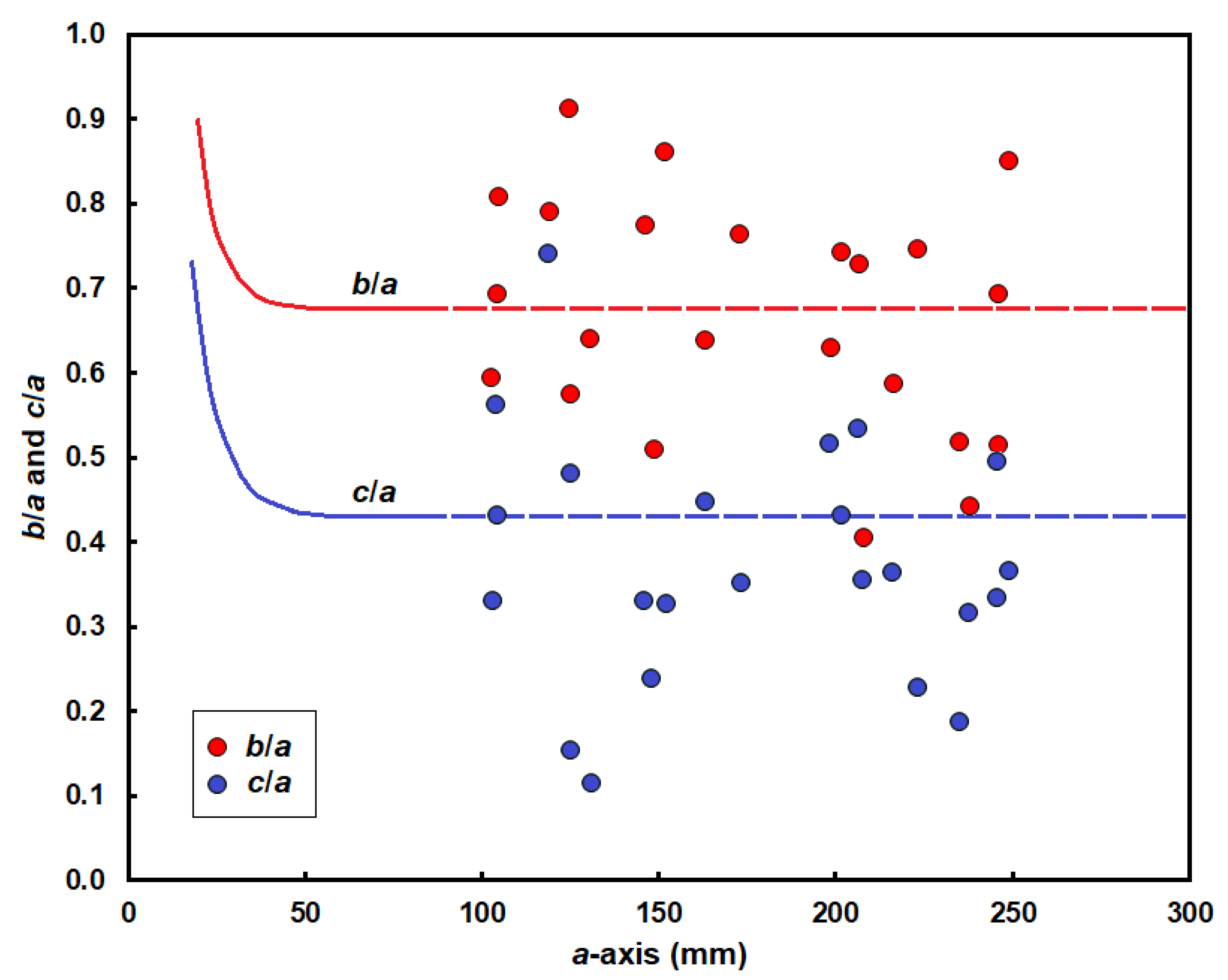
  • Form: a measure of the relative lengths of the three main orthogonal axes of a particle. (Any particle may be considered to possess an a-axis, the longest axis; a b-axis, the longest axis at right angles to the a-axis; and a c-axis, the longest axis orthogonal to both the a- and b-axes.) Thus, a particle may approximate to a sphere, with all three axes nearly equal in length; to a disc or plate, with one axis much shorter than the other two; to a rod, with one axis considerably longer than the others; to a blade, with one axis much longer and one far shorter than the b-axis; or to any intermediate form.
  • Sphericity: a measure of how nearly equal in length are the three major axes of a particle. Although sphericity is a component of form, the property is worthy of separate definition because of the way it reflects the behaviour of a particle in a fluid.
  • Roundness: a measure of the smoothness and lack of angularity of a particle’s surface.
  • Surface texture: the range of features that may be found on the surface of particles.

2.3. The Characterisation of Gravel Shape

A wide variety of methods has been proposed for the quantification of gravel shape [21,22,23]. The approaches used here have been selected on the basis of a number of criteria. In broad order of importance these are: the ability of the measure properly to characterise shape; the success with which it distinguishes different shapes; the extent to which the measure reflects the sedimentary behaviour of particles; the degree to which samples of gravels display normal shape-frequency distributions when the measure is applied to them, allowing their analysis by parametric statistical methods; ease of use; broad acceptance; and common use.
Although the surface texture of sand grains has been the subject of intense investigation, few attempts have been made to study the surfaces of larger particles and little effort has been made to treat gravel surface textures in anything but a qualitative manner. For this reason, surface textures are not considered in the following discussion. The remaining three elements have been measured as follows:
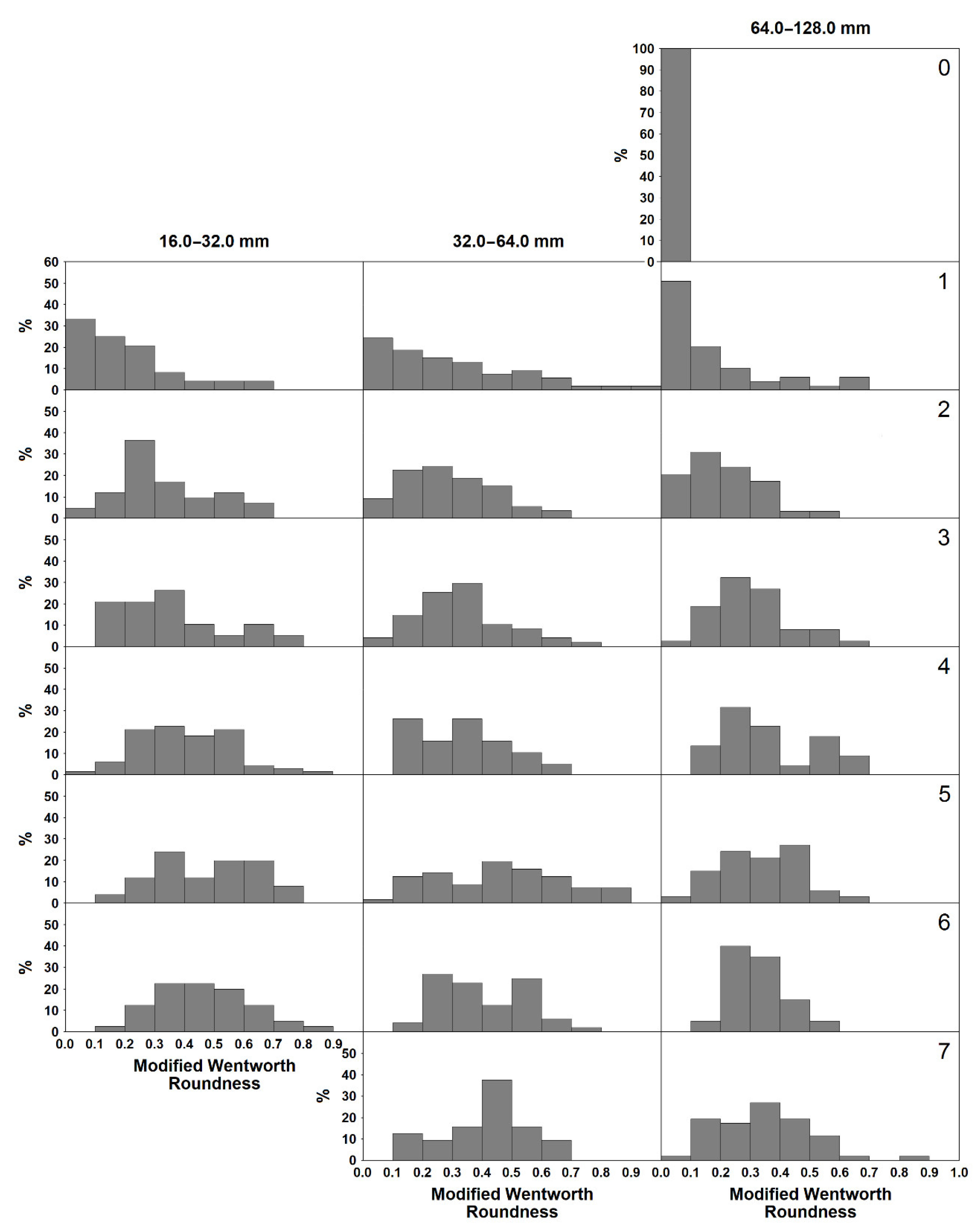
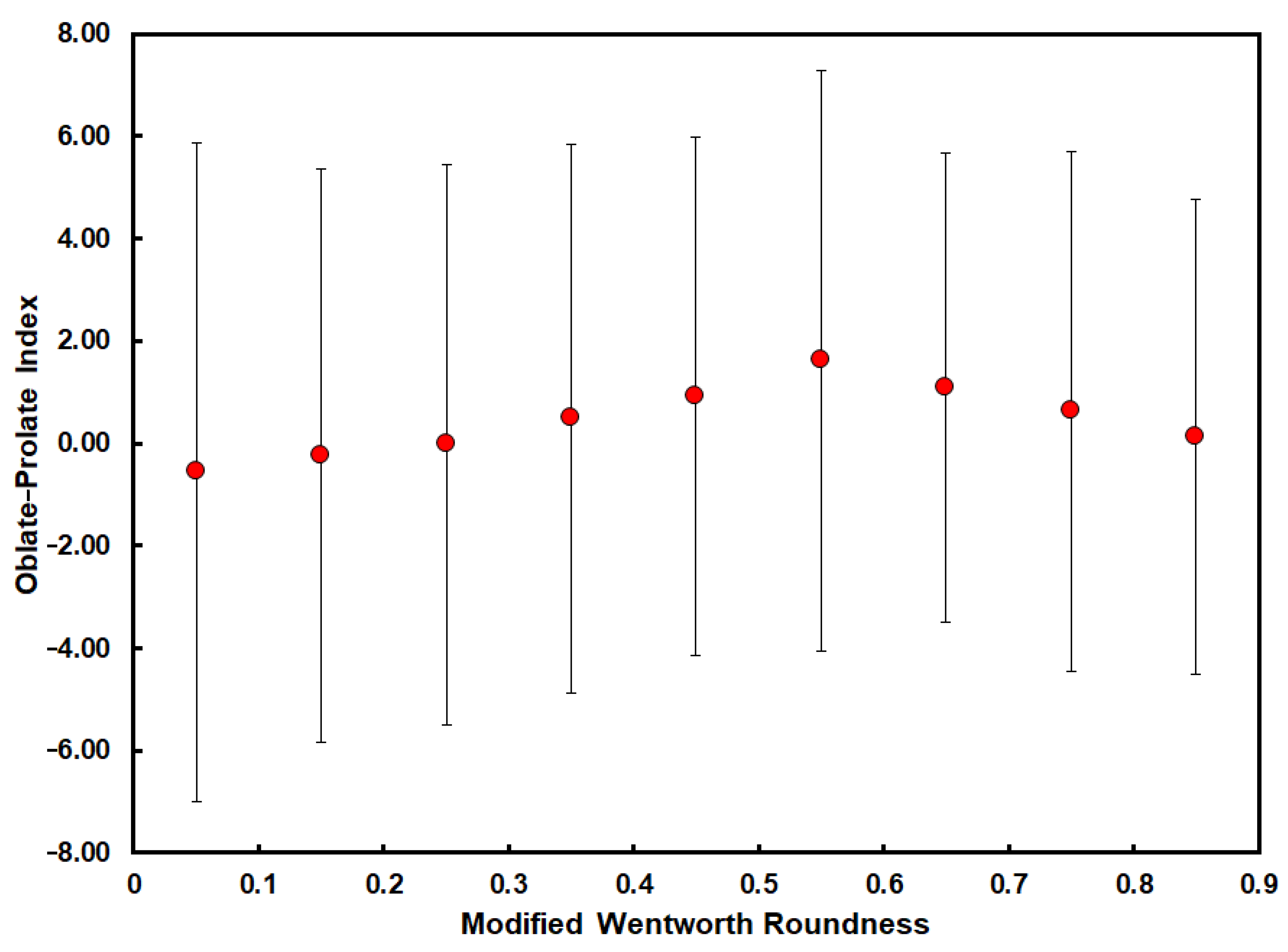
  • Roundness: there are two main approaches to the determination of roundness. One is that of Wadell [24,25]. This involves the measurement of the diameter of each corner of the maximum projection outline of the particle. This procedure is extremely time-consuming and several attempts have therefore been made to produce sets of particle images of predetermined Wadell Roundness with which the maximum projection outline of each particle can be compared. Unfortunately, this method suffers from very poor reproducibility, both between operators and with individual workers [12,26], and has not been adopted here.
    The second approach is that of Wentworth [3,27]. This relates the diameter of the sharpest corner of the maximum projection outline to some measure of particle size. Barrett reviewed these methods of measuring roundness and concluded that the Modified Wentworth Roundness (RWt) measure of Dobkins and Folk [15] is to be preferred [22]. This is the method used here.
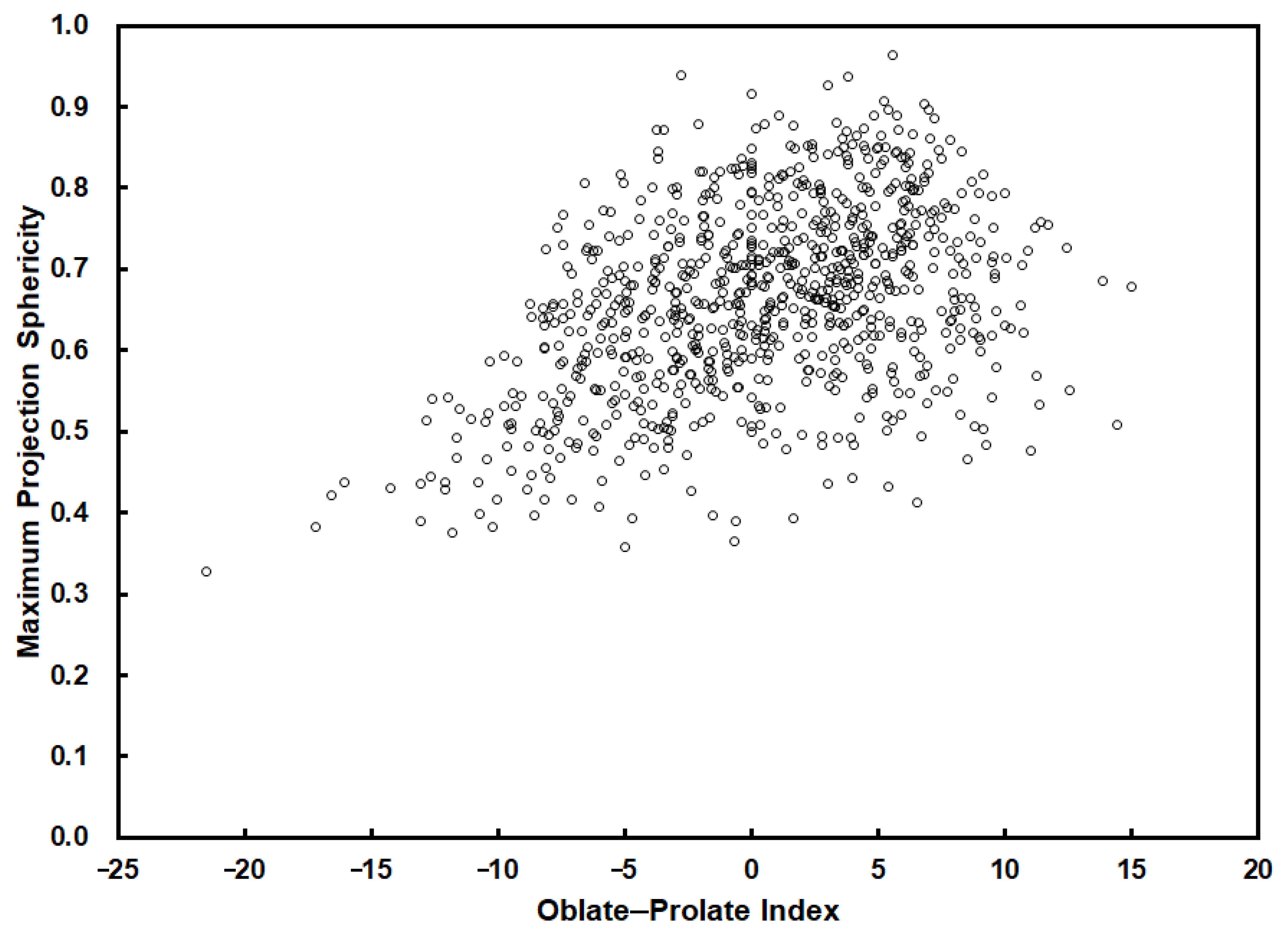
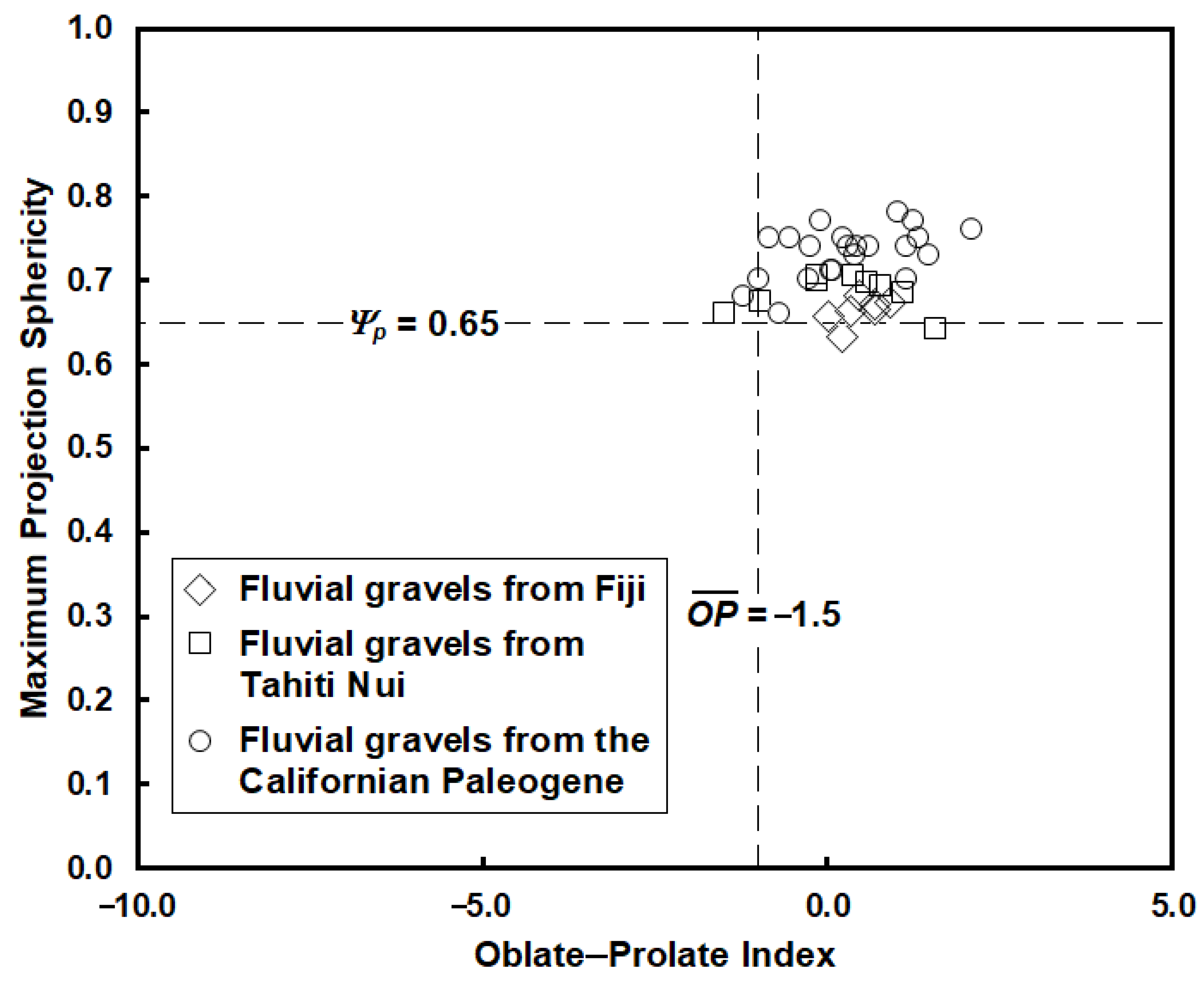
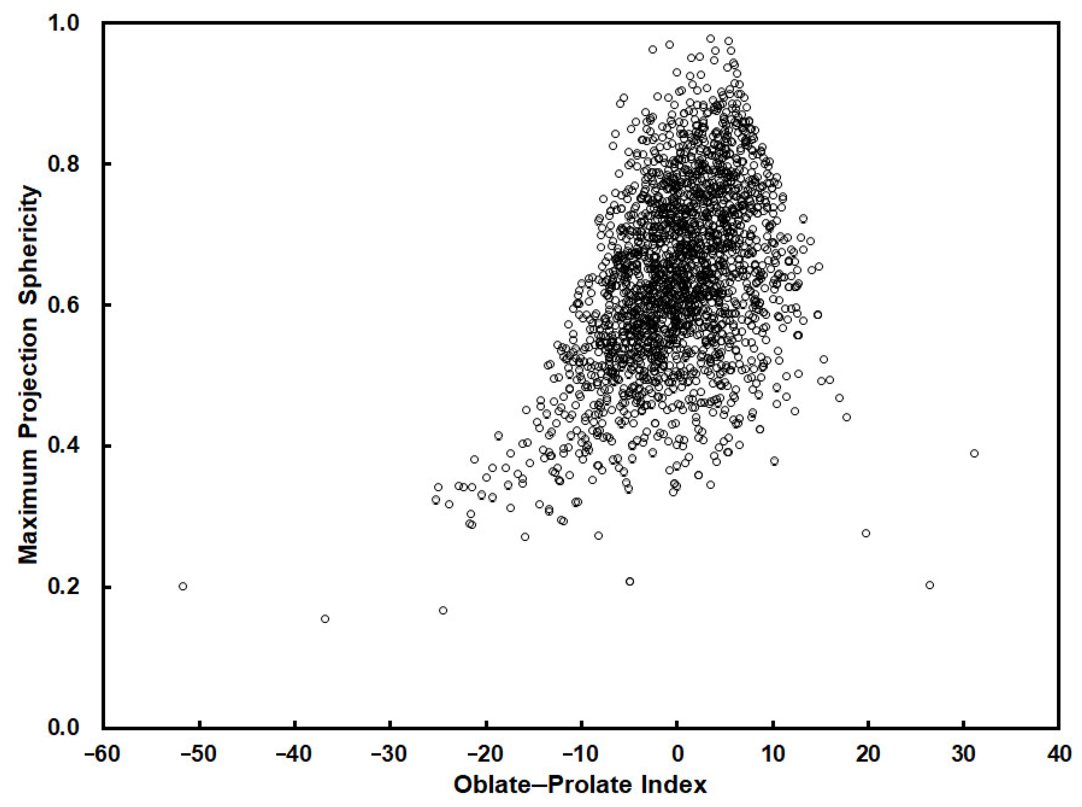
  • Sphericity: the measure of sphericity that appears best to reflect the hydraulic behaviour of particles is the Maximum Projection Sphericity (Ψp) [12,14,28]. This displays a close and direct relationship with the velocity at which a particle of a particular volume will settle in a fluid or roll on a bed. Maximum Projection Sphericity represents the ratio of the maximum projection area of a sphere of the same volume as the particle to the maximum projection area of the particle itself. Values of Ψp range from 0 to 1. A perfect sphere has a value of 1. The more discoidal a particle, the more Ψp tends to zero.
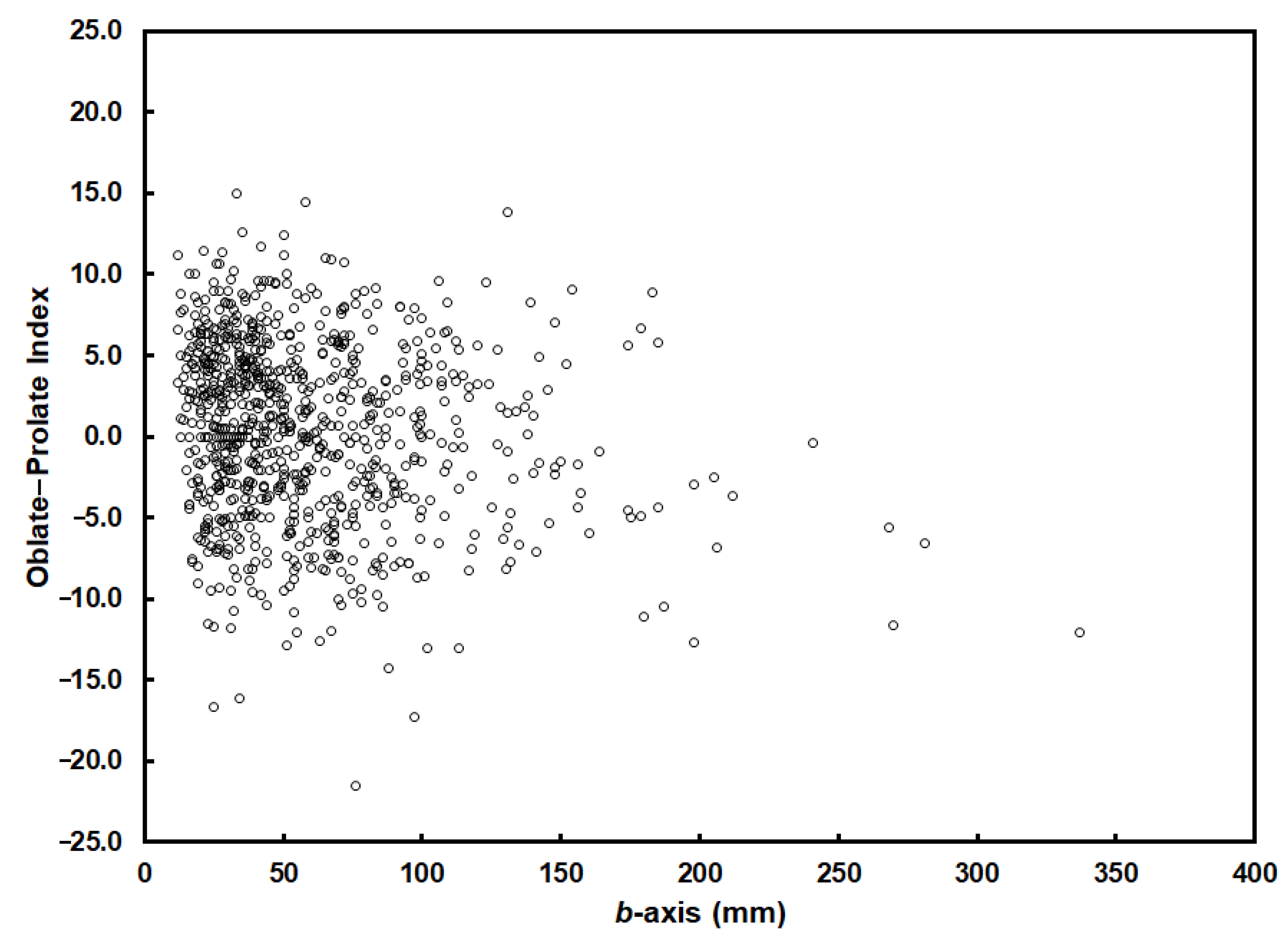
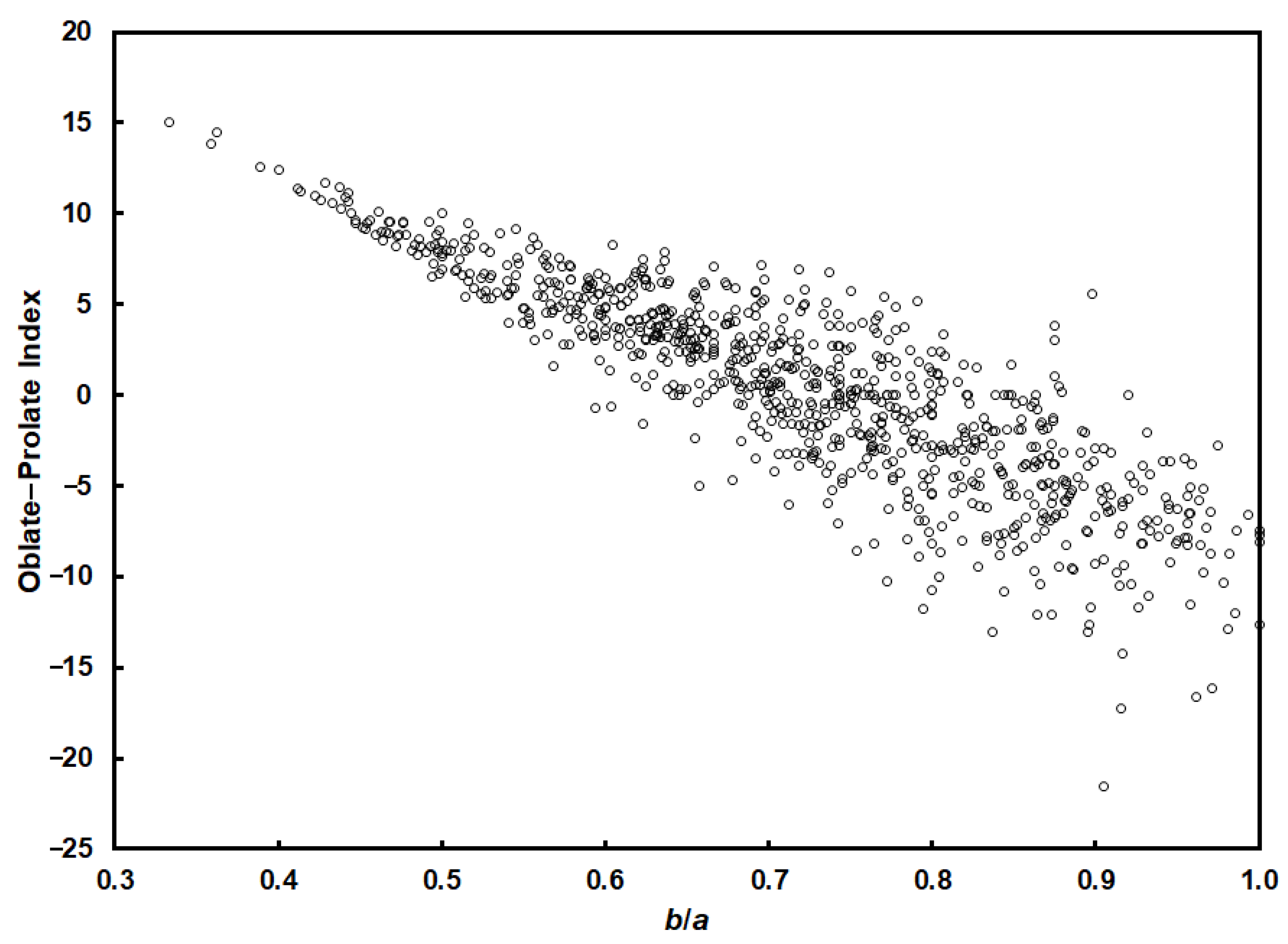
  • Form: the measure that combines effectiveness in discriminating particles of different form with a single numerical value whose distribution is nearly normal for samples of most gravel types [22] is the Oblate–Prolate Index ( O P ¯ ) of Dobkins and Folk [15]. Values of O P ¯ vary from −∞ to +∞. A perfect blade (one in which the length of the b-axis is exactly halfway between the lengths of the a- and c-axes) has a value of zero. Discs have negative values and rods have positive values. A perfect sphere (one whose a-, b- and c-axes are equal in length) has a value of –5. However, the Oblate–Prolate Index is extremely sensitive to even the smallest departure from sphericity and O P ¯ is better regarded as a measure of the position of a particle along the disc–blade–rod continuum. The Oblate–Prolate Index thus provides a measure of the tendency of particles to roll during sediment entrainment.
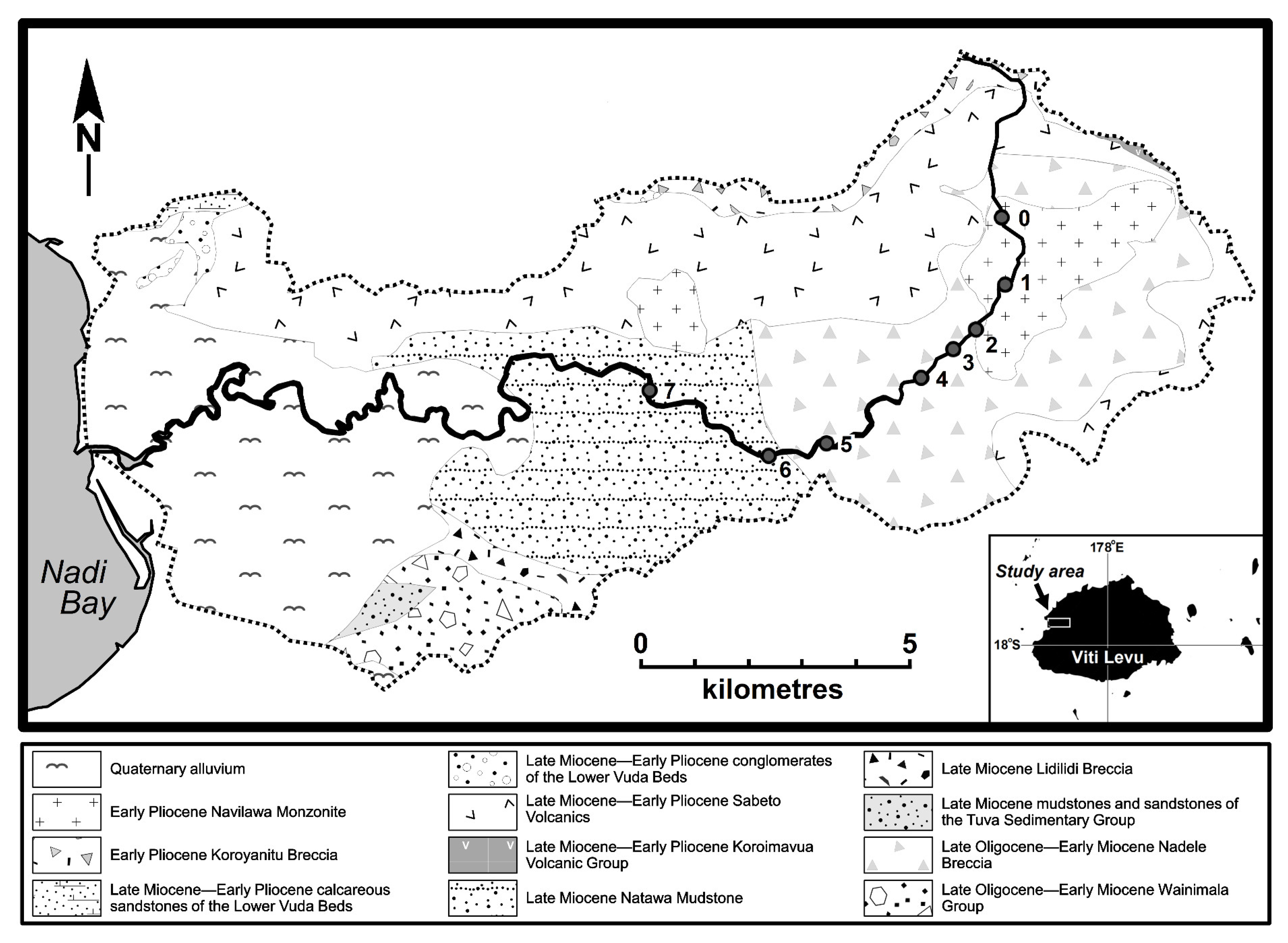
3. The Sabeto River

The Sabeto River drains the Sabeto and Mount Evans Ranges of western Viti Levu, Fiji (Figure 1). The river’s catchment is narrow and elongate. It is underlain by sedimentary, intrusive, volcanic and volcaniclastic rocks of Late Oligocene–Early Pliocene age [29,30,31] (Figure 2). The catchment extends over 137 km2 and reaches an altitude of 1195 m asl on its northeastern margin. The trunk stream is 34.8 km long. It rises at an elevation of just over 1000 m on the northern rim of the great amphitheatre within which lies the village of Navilawa. The river leaves the amphitheatre at its southwestern corner and flows west to reach the ocean at Nadi Bay. The river possesses few significant tributaries capable of introducing coarse sediment into the main channel. Above between 15 and 18 km downstream, the river flows in a relatively confined valley and the hillslope and channel systems are closely linked, although we have no information on the efficiency of sediment influx into the channel. Beyond that point, the valley widens and the presence of a floodplain means that the channel is decoupled from the surrounding hillsides.
The closest meteorological records are from Nadi Airport, 4 km southeast of the mouth of the river. Temperatures vary little. Mean daily minima range from 18.5 °C in July to 22.8 °C in January, whilst mean daily maxima vary from 28.5 °C in July to 31.5 °C in January (1942–2003 records; source of data: Fiji Meteorological Service). The mean annual rainfall is 1864 mm, with a drier winter (the mean precipitation in July is 49 mm) and a wet summer (the mean precipitation in January is 312 mm), although high daily falls may be expected at any time of the year. The climate lies within the Aw (tropical monsoon) category of Köppen’s climatic classification [33].
The catchment lies in the south Pacific tropical cyclone belt and the river experiences frequent floods associated with cyclonic rainfall. Records are poor, but there were major cyclone-related floods in October 1972, February 1974 and February–March 2001 [34]. Although there is no record of its magnitude, the 1972 event, associated with Tropical Cyclone Bebe, appears to have been particularly severe. The village of Nadele in the valley bottom was so badly affected that the entire settlement was abandoned and its occupants moved to a new site (named Korobebe after the cyclone).
Limited river flow data are available for the catchment. The estimated 6 h extreme rainfall at Nadi Airport was used to model the 10- and 50-year floods at the catchment outlet [35]. Values of 79.3 and 292.3 m3 s−1 respectively were obtained using this approach.

4. Sampling

Seven stations at which fluvial gravels of monzonite were sampled were established along the length of the river, one above the downstream boundary of the outcrop of the Navilawa Monzonite, the rest below (Figure 1 and Figure 2). The downstream limit of sampling lies at the confluence of Nawainiu Creek with the trunk stream. Since the Navilawa Monzonite outcrops along the headwaters of the creek, below this point new sources of monzonite may be added to the system, complicating the story of particle evolution.
The active channel was defined as comprising the unvegetated part of the cross-section. At each sampling station, a transect was established normal to the river and across the entire width of the active channel. Every gravel of Navilawa Monzonite ≳ 10 mm lying on the stream bed beneath the transect line was sampled. If a minimum of 99 clasts was not obtained, the transect was moved 1 m downstream and sampling continued along the entire length of the new transect.
Samples of freshly weathered gravels of Navilawa Monzonite were taken from the edge of the bedrock channel of the Sabeto River at Station 0 to obtain information on the shape of the material prior to its introduction to the fluvial system.
The Modified Wentworth Roundness, Maximum Projection Sphericity and Oblate–Prolate Index of each of the sampled gravels was measured and recorded following the procedures given by Gale and Hoare [20]. The raw and processed measurements are available at Mendeley Data, V1, doi:10.17632/gwnfv4c6b5.1 [36].
In the text that follows, we employ the particle-size conventions of Wentworth [37]. Note that particles of diameters >2.0 mm are referred to as gravels. These are subdivided into granules (2.0–4.0 mm), pebbles (4.0–64.0 mm), cobbles (64.0–256.0 mm) and boulders (>256.0 mm). Particle size is defined on the basis of b-axis length.

5. Roundness

5.1. Introduction

Roundness is generally thought to be a product of attrition, the result of particles colliding and rubbing against one another and against the stream bed. It is thus a measure of the distance or time of particle transport. More particularly, roundness provides an index of the role of attrition in fluvial systems and the part it plays in generating one of the most notable and conspicuous characteristics of rivers, the tendency of fluvial bed sediments to become finer with distance downstream. This exerts a primary control on river geomorphology, it affects particle mobility, it influences the size distributions of fluvial sediments and it contributes to our understanding of the sedimentary processes that operate in rivers. More directly, rounding has also been used to infer past alluvial environments, notably on Mars, where rounded pebbles have been employed as compelling evidence of ancient fluvial conditions [38].

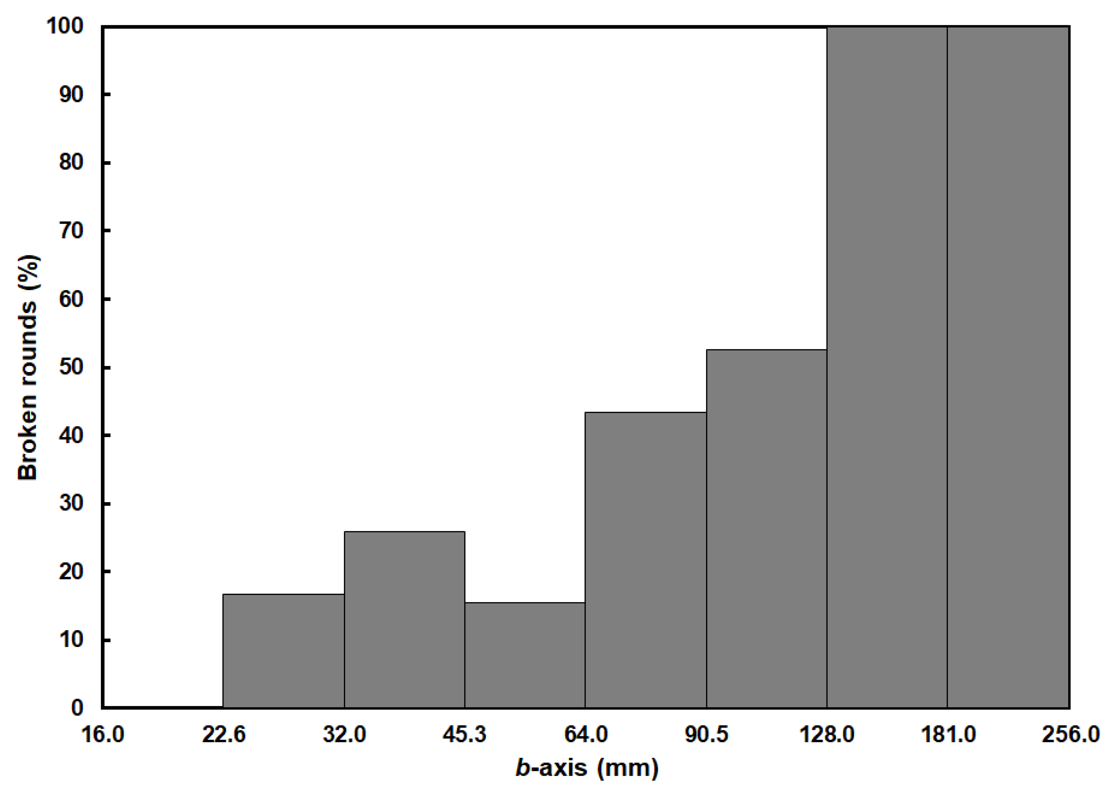
5.2. The Rounding Process

Those particles liberated from the bedrock or reworked from the regolith and subsequently incorporated into the fluvial system may possess a wide range of initial shapes and sizes. Once introduced to the river environment, they are subjected to physical processes (including splitting, crushing, chipping, grinding, cracking, sandblasting and vibratory abrasion) and a range of chemical processes [10,39], all of which act to reduce their size and to alter their shape. River gravels may also be exposed to intermittent weathering, making them more susceptible to processes of shape alteration and size reduction.
The processes of chipping, grinding, intermittent weathering and vibratory abrasion are all likely to act to increase roundness. Sandblasting may smooth a particle’s surface, but is likely to be significant only for boulder and cobble grades. With the possible exception of the very finest particles, crushing is unlikely to play an important role in shaping gravels. Similarly, the part played by chemical processes is likely to be minor, even in the case of relatively soluble lithologies. And, whereas cracking is near-ubiquitous, its direct effect on shape seems limited (although it may enhance the effects of weathering). Splitting appears to be largely confined to cobble and boulder grades, although the process may be indirectly important in contributing freshly fractured material into smaller size grades [40]. The resultant components will generally be more angular than the original particle.
The sum of all these processes is defined here as attrition. Attrition thus represents the combined effects of abrasion, those processes that act to increase roundness, and breakage, which fragments the particle and generally increases angularity.
The effectiveness of each of these mechanisms varies with clast lithology, with the existence of potential fractures on the particle surface and with any weathering that the clasts may have experienced. Weathered particles, in particular, may experience rates of attrition an order of magnitude above those of the unweathered rock, with a sharp decrease in attrition rates once the modified surface layer has been removed [41,42,43,44]. Since protuberant elements of the clast are likely to possess a greater depth of weathering than other parts, the effect of weathering prior to the introduction of the clast into the fluvial environment will generally be to increase the rate at which particles are rounded.
The operation of each wearing mechanism may also vary with clast impact velocity, particle size, the frequency and nature of clast contact during motion, and the presence or absence of a suspended sediment load. Other considerations include whether the particles are rolling, sliding or saltating along the bed, singly or in groups; and whether they are stationary but subject to collision with overpassing sediment [10].

5.3. Downstream Changes in Gravel Roundness

The roundness of the sediment on the bed of the Sabeto River increases as a function of the logarithm of distance downstream (Figure 3), conforming with the general pattern reported in rivers worldwide (at least for mechanically coherent lithologies and in geologically straightforward situations) [45]. Such a relationship is entirely to be expected given that only a short distance of transport is required to increase the roundness of an angular pebble substantially, whereas an already smooth pebble must undergo substantial abrasion to improve its roundness still further [10]. Wentworth suggested that the transition from rapid rounding in the early phase of particle transport to more gradual change further downstream is associated with a transformation in the nature of attrition [46]. The angular particles characteristic of the river’s headwaters are rounded by processes operating on the sharp edges of the particle. Once the angular corners are removed, however, rounding becomes dominated by grinding of the remaining relatively smooth surface, a much slower process.
Information on the baseline state from which the evolution of particle shape in the river may be tracked is provided by the sample from Station 0. This represents the shape of the particles as liberated from the rock. Without exception, these primitive particles are very angular, in all cases possessing RWt values < 0.1 (Figure 4). Interestingly, despite the belief that, irrespective of the processes involved in their formation, fragments generated by the breakup of solids possess a universal shape, the freshly weathered particles measured as part of this investigation differ dramatically in form from the products of impact, explosion and weathering reported by Domokos et al. [47]. Notably, our data fail to support the view that, as particle size increases, the shape of such solids converges exponentially on ‘a unique elongated form’ (Figure 5).
The furthest upstream of the sites sampled along the channel (Station 1) lies upriver of the monzonite boundary. The three size fractions studied at this location (16.0–32.0 mm, 32.0–64.0 mm and 64.0–128.0 mm) are all dominated by angular material (Figure 4). At first sight, this is suggestive of the active recruitment of material to the sediment load from the substrate. But 64% of those particles of RWt < 0.1 and 60% of those particles of RWt = 0.1–0.2 in the 64.0–128.0 mm fraction consist of broken rounds. Given that many of the remaining angular particles in this fraction are likely to have experienced less obvious breakage, it is probable that the bulk of the angular component in the 64.0–128.0 mm fraction is not primary material in its initial phase of rounding. Instead, it must have undergone at least one and perhaps more episodes of abrasion, fracturing and catastrophic size reduction. This is quite contrary to the implicit model of consistent and systematic rounding offered by most studies of downstream particle evolution (for example, Mills [45]).
The proportion of broken rounds amongst the angular gravels in the finer fractions at Station 1 is considerably less than in the 64.0–128.0 mm fraction (Figure 6). One explanation for this may be that, because of their size, larger particles possess momentum. They therefore experience preferential breakage as a result of collision with the channel boundary and with one another. By contrast, finer particles are of lower mass and breakage due to collision is uncommon. Nevertheless, the finer fractions retain their angularity. This may be because they receive the by-products of the chipping and crushing of larger-sized material. Such a mechanism was invoked by Bluck to explain the angularity of particles <32.0 mm and >128.0 mm on gravel beaches [40]. Support for this thesis comes from the distinctive size-distribution of broken rounds at the site (Figure 6). Despite the dominance of angular particles, the 16.0–22.6 mm fraction possesses no broken rounds, whereas broken rounds make up the entirety of the 128.0–256.0 mm fractions. It is possible that the skewed patterns of angularity across all three size fractions at the site (Figure 4) is the product of two distinct processes: fracturing of the cobble- and boulder-sized component and the filtering of the by-products of breakage into the pebble-sized fractions.
This breakage process has significant consequences for the way in which particles round downstream. Both along the Sabeto (Figure 3) and along rivers in general [45], gravels appear to display an asymptotic pattern of downstream fining. Yet the nature of the breakage observed at Station 1 suggests that the route tracked by any individual particle is far more complex than this, with roundness following a saw-toothed pathway characterised by quasi-random reversals to an angular state. Unfortunately, the data reported in most studies are inadequate to assess whether the particles at an individual site are proceeding along a systematic path of rounding or whether they possess a more complex history of intermittent re-setting of the rounding process. In the case of the Sabeto, the fact that the range of roundness values displayed at any individual downstream site along the river is large suggests that particles, even if of identical lithology and similar size and distance of transport, each follow particular paths of rounding. On the other hand, there is little evidence that, downstream of Station 1, particles are fracturing catastrophically and generating large numbers of angular particles. Thus, the proportion of highly angular (RWt < 0.1) gravels at Station 2 is far less than that at Station 1 (Figure 4), whilst further downstream such particles are rare or non-existent. Beyond Station 1, in other words, it appears that processes of rounding dominate those of the breakage. This is entirely predictable, for unless this were so, the assemblages of rounded forms that are characteristic of rivers could never come into existence.
At least two explanations may be offered for this shift in the relative importance of breakage. The first is that the downstream fining typical of most fluvial systems means that cobble- and boulder-sized particles become increasingly rare with distance along the channel. With the removal of these particles from the river’s bedload, clast breakage occurs less frequently and an important means by which angular particles are generated is halted. Secondly, river headwaters are typically dominated by cascade and step-pool channels [48]. These are steep, with rough boundaries and coarse-grained bed material. The mobilisation of these sediments and their interaction with channel boundaries during moderate- and high-magnitude floods is likely to cause breakage and to generate angular particles. By contrast, the gentler reaches further downstream, often lined with finer sediment, may minimise the frequency of impacts and reduce the production of angular particles by breakage. It is notable that, in the case of the Sabeto, there is a marked shift in channel morphology from cascades and step-pools to a plane-bed form 0.2 km upstream of Station 1 (Figure 7). On this basis alone, the sediments of Station 1 might be expected to be dominated by the products of upstream breakage, whilst further downstream the products of abrasion make up the bulk of the sediment assemblage.

5.4. The Concept of Limiting Roundness

Sneed and Folk [14] and Plumley [49] have reported limiting mean roundness values of river gravels of 0.63–0.65 and 0.73–0.74 respectively. These measures agree with those generated by laboratory investigations of particle attrition [3,4,10], although it is unclear how well the laboratory environment replicates the reality of natural rivers. At odds with this body of work is that of Miller et al. who predicted that, assuming curvature-driven abrasion, the roundness and c/b and b/a ratios of a particle would increase monotonically downstream, the ultimate result being spherical particles with a roundness of 1.0 [50]. Novák-Szabó et al. developed this thesis further, arguing that large particles transported as bedload experience chipping, which leads to rounding, driving the particles toward a spherical and perfectly rounded shape [18]. Despite the claim that these processes may be observed along the Río Mameyes in northeast Puerto Rico [50], our interpretation of the data is that even at the furthest downstream sampling site, the roundness and axial ratios lie far from their theoretical destination and are not convincingly demonstrative of a smooth and monotonic trend to a spherical and perfectly round end-point. This point was conceded by Miller et al., who admitted that frictional abrasion in the lower reaches of the river prevents their pebbles from reaching the end-shape associated with collision-induced abrasion [50].
The highest mean values of ~0.35–0.45 at the downstream end of the study reach in the Sabeto lie well below the generally reported roundness limits of fluvial gravels, suggesting that additional rounding is likely to occur as the particles are carried further downstream. It is possible that these low values are in part an artefact of the use of the Modified Wentworth Roundness measure. This records only the sharpest corner of the maximum projection plane and will yield lower values than other estimates of roundness [20]. Nevertheless, the maximum mean values of RWt of 0.64–0.70 obtained in fluvial environments by Howard [51] suggest that, in the case of very round particles, the offset from other roundness measures is likely to be small.
Notwithstanding this, those samples from downstream sites along the Sabeto all contain particles whose roundness lies close to or beyond the limiting values reported from fluvial environments, whilst also consistently containing gravels of RWt < 0.2 (Figure 4). We have argued above that the presence of low roundness values at downstream sites is not solely because some particles round slowly and reach these locations in an angular state, but because splitting takes place and the rounding clock is re-set. This strongly suggests that the rounding process is not simply one in which all particles of a given size and lithology ultimately converge on a particular state. Instead, the transporting process appears to subject particles to various forms of roundness degradation with the result that the roundness of any given particle is continually being re-established to close to zero. Overall, therefore, the roundness population is likely to reach a dynamic equilibrium that lies far below the theoretical end point of 1.0.
Although there is a range of ways in which a particle’s roundness may be re-set, it is conceivable that catastrophic breakage plays an important role. This was first suggested by Tricart and Schaeffer in 1950 [52]. However, from the rarity with which broken rounds occur on beaches and downstream of cataracts, the near-absence of particle breakage in experiments on the breakdown of gravels during fluid flow, and the impossibility of splitting pebbles even when dropped from heights of up to 7 m onto pebbly surfaces beneath shallow water, Kuenen argued that splitting is very rare in hydraulic environments [10]. This assessment was supported by Dobkins and Folk, who noted that, on Tahiti Nui, ‘[d]espite the tremendous impact of pebbles against each other, broken pebbles were almost never seen on the high-energy beaches.’ [15].
Gainsaying this is Bluck’s evidence of particle splitting on South Welsh beaches, particularly in the boulder grade (though his published results group together split and chipped gravels, making it difficult to calculate the proportions attributable to each process) [40]. Similarly, although she provided no measurements, Oak observed widespread and highly visible breakage on the boulder beaches of Australia’s New South Wales coast [53]. Our observations also reveal significant numbers of broken rounds (the products of particle splitting) at Lennox Head Beach in northern New South Wales, peaking in the 90.5–128.0 mm fraction (Figure 8). Breakage also appears to be common in fluvial environments. Apart from the data presented here, Malarz reported that 14–49% of clasts between 16.0 and 256.0 mm in diameter were broken during the 1997 and 2001 floods along the Soła and Skawa rivers in the Polish Carpathian Mountains [54], Lewin and Brewer noted that between 0 and 26% of 16.0–32.0 mm diameter pebbles on the beds of the Rivers Severn and Dyfi in Wales were broken [55], whilst Bretz found that broken rounds made up between 12.5 and <30% of the pebbles on active bars in the Snake River of Washington, USA [56]. We venture that breakage is so common amongst particles of cobble grade in fluvial environments that it alone may be sufficient to prevent particle assemblages from reaching roundness values approaching 1.0.
The frequency with which larger particles experience splitting may reflect their mass and thus the momentum with which they may collide. The decline in splitting in larger sizes at Lennox Head Beach (Figure 8) may be because bigger particles are rarely mobilised and thus rarely collide with sufficient momentum to fracture. By contrast, despite being easy to entrain and subject to frequent collision, particles of ≲64.0 mm may possess insufficient mass to cause breakage. This may be why Kuenen failed to observe splitting in his experiments, which generally involved particles of no more than 60 mm diameter [10].

5.5. The Role of Particle Size

According to Dobkins and Folk, river gravels display no significant change in roundness with size over the range from 16.0 to 256.0 mm [15], though this assertion sits uneasily alongside the results of several studies that show that the rate of downstream rounding is greater for coarser particles than for smaller [14,49,57]. The conventional explanation for this is that the rate of abrasion of larger particles is greater than that of small, a suggestion made first by Gabriel-Auguste Daubrée in 1879 [4] and widely supported over the succeeding century or more [10,55,58,59]. The consequence of this is that, if the particles in a sediment are initially equally angular, the difference between the roundness of the largest and the smallest particles will become greater as attrition proceeds and as the particles move downstream.
Despite this, the downstream patterns of rounding along the Sabeto reveal that the finer gravels are consistently rounder than the coarser (Figure 3). This suggests that under certain circumstances the conventional model may be overridden by one or more opposing processes. The most obvious of these is that mechanisms such as splitting and chipping, both capable of producing more angular clasts, are likely to play a more important part for larger than for smaller particles and result in higher angularity amongst coarser particles.
Secondly, the conventional model ignores the fact that as abrasion occurs, particles will become smaller. Over time, therefore, progressively better-rounded particles will migrate down the size scale to populate the finer fractions of the deposit, inverting the accepted relationship between size and roundness.
Thirdly, as demonstrated by Sternberg’s Law, particle size is (all other things being equal) a measure of the distance that a particle has been carried along the fluvial system [60]. Under these circumstances, a small particle is likely to be transported further and may experience greater abrasion than a large particle. It might be thought that this argument cannot apply in the case of the Sabeto, where all the particles studied are composed of rocks derived from the same outcrop and every gravel at a site would have travelled a similar distance downstream. But the monzonite outcrop extends for perhaps 3 km along the upstream channel (Figure 2). It is conceivable, therefore, that differences in the transport distance of clasts from the same sample could reach several kilometres, easily sufficient to account for the observed differences in particle rounding.

6. Sphericity

6.1. Introduction

The shape of the particles that make up the bedload of rivers is generally thought to be a product of attrition, selective sorting (by which particles of particular shapes are preferentially transported further and faster downstream, whilst other shapes are preferentially deposited) or some combination of the two. Attrition and size sorting have been widely investigated in efforts to explain the downstream decrease in the size of river-bed sediments, with most commentators arguing that the role of sorting is dominant [32]. Size sorting and shape sorting are not the same, however, and we cannot necessarily apply conclusions derived from studies of downstream fining to those of downstream changes in particle shape.

6.2. The Differential Transport of Fluvial Bedload

The principle of the selective entrainment, carriage and deposition of gravels of different size and mass by fluid flow is well established. However, particle shape may also play a significant role in differential movement. Perhaps the earliest demonstration of this was by Krumbein, who showed that the more spherical a particle the more likely it is to be entrained downstream and the higher its rate of bedload movement with respect to flow velocity [61]. Lane and Carlson confirmed that spherical pebbles are more susceptible to movement as bedload than discoidal ones [62]. Similarly, Ashworth and Ferguson found that spherical gravels move further than flat ones [63], whilst Hattingh and Illenberger reported that spheres are entrained in larger numbers and are carried further by floods than (in order) rods, blades and discs [64]. Schmidt and Ergenzinger, on the other hand, noted that, whilst the discoidal component of the fluvial pebble fraction moved rather short distances, it was rod-like pebbles that were carried furthest and were most likely to be entrained [65]. Despite this, they found no significant differences between the distances moved by rods, ellipsoids and spheres, with all travelling significantly greater distances than discs. Discs overall displayed the lowest probability of transport (although they appeared to possess a transport advantage during the single, extreme flood monitored during the project). The conventional story was repeated by Stott and Sawyer, whose investigation of fluvial bedload confirmed that rods and spheres had the highest rates and the greatest distances of travel, with discs and blades the lowest [66]. Likewise, Cassel et al. found that spheres constituted the fastest and furthest-travelled component of fluvial bedload, followed by compact blade-shaped particles, and discs and elongated blade-shaped particles [28]. Significantly, distance of travel was strongly correlated (r2 = 0.94) with Ψp.
Like other workers, Carling et al. found that on smooth beds, spheres moved faster than discs, but, as the bed became rougher, spheres moved more slowly, and oblate and flat particles rolled more easily [67]. Demir made similar observations [68]. On smooth beds, spheres and rods moved faster than blades and discs, whilst on rougher beds, spheres tended to follow irregular courses, their movement impeded by obstacles. By contrast, discs and blades moved by sliding over the rough surface. Demir also recognised that the influence of shape on transport distance was less important for finer (32.0–64.0 mm) particles, and that the distance of transport was more strongly shape-selective in coarser (64.0–128.0 mm and >128.0 mm) classes.
Schmidt and Gintz found shape to be of little importance in determining the bedload travel length of small particles, which were trapped between cobbles and boulders [69]. For coarser particles, however, transport was strongly shape-selective, with spheres, and in some cases rods, travelling the greatest distances, and discs showing the highest resistance to entrainment.
These observations confirm the belief that particles may be sorted by shape during bedload transport. Our understanding of the relative roles of shape and size in this, however, remains imperfect. A large particle of high sphericity, for example, may be more rollable and may move more easily during a flood than a smaller particle of low sphericity and low rollability. Significant too may be the propensity of small particles to be trapped amongst larger gravels and thus to be hidden and sheltered from the flow. Meanwhile, and irrespective of their shape, larger particles tend to penetrate into the flow, where they are exposed to greater fluid force.
Complicating the narrative further, it is possible that under certain conditions particle mobility is neither size nor shape dependent. Instead, particles of a wide range of sizes and shapes may begin to move simultaneously during a transport event [70,71]. This condition of equal mobility might appear to be counterintuitive. Should it not be easier for a flow to transport the finer (and more spherical) fraction than the coarser (and more discoidal) component? There are, however, two countervailing factors. First, the hiding–sheltering effect, whereby larger particles are more exposed to the flow and thus to greater fluid force, whilst smaller particles are sheltered by larger particles from the forces imposed by the fluid. Secondly, the rollability effect, whereby larger particles are able to roll over a bed of smaller particles, whilst smaller particles cannot. It is the simultaneous operation of the particle-size effect, the hiding–sheltering effect and the rollability effect that results in the transport of loads of mixed particle-sizes [72].
This story has been refined by Mao and Surian, who suggested that the coarse and fine fractions of fluvial bedload may be transported in different ways [73]. Once entrained, larger particles are entirely exposed to the flow. They possess high inertia and are less likely to be trapped by immobile particles on the channel bed. They may thus be carried long distances. For this fraction, movement is size-selective. By contrast, smaller particles may be hidden amongst other particles on the channel bed, with movement taking place only under equal-mobility conditions. In their study, the threshold between equal-mobility and size-selectivity lay at around 32 mm.

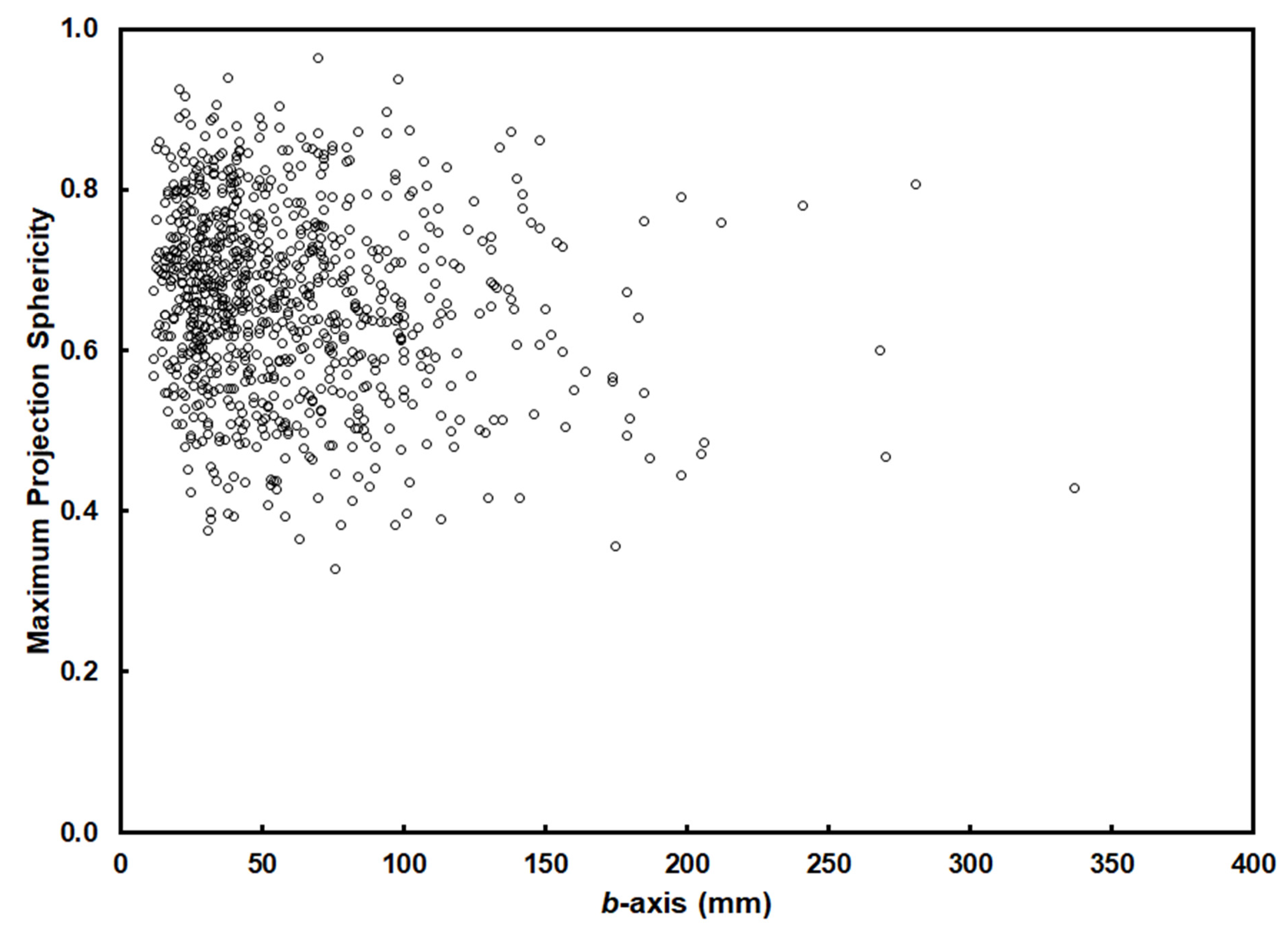
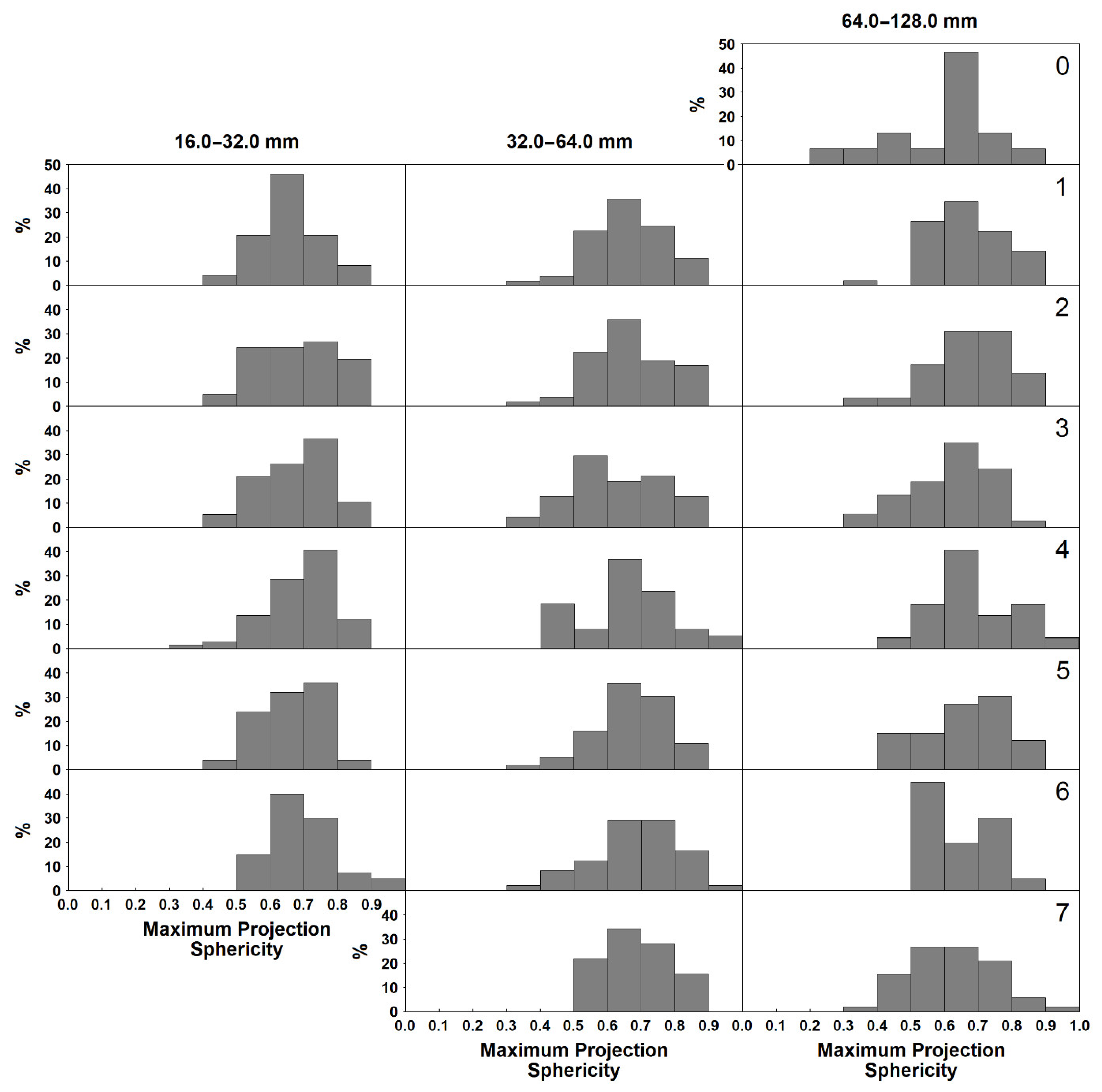
6.3. Particle Size and Sphericity in the Fluvial Environment

Our understanding of the role played by particle size in the sphericity of fluvial gravels has been frustrated by the reluctance of researchers to share the data upon which their speculations have been based. Sneed and Folk, for example, reported that ‘… measurement of a great many diverse pebble suites … has shown that, above about 8 mm., the sphericity commonly decreases as the pebbles get larger …’ [14]. Unfortunately, they provided no information to allow us to assess the strength of that relationship and how it might vary in different environments. Similarly, after measuring over 42,000 clasts, Ibbeken and Schleyer concluded that Ψp increases with grain size, although their measurements were confined to particles of 16.0–80.0 mm and brought together in a single data set measurements made on half a dozen or more different lithologies and on samples from a range of different environments [74]. More nuanced, though no less enigmatic, evidence includes that of (i) Allen, who reported that fluvial pebbles displayed a positive relationship between size and sphericity [75]; (ii) Sneed and Folk, who found that for fluvial pebbles of quartz and chert, larger particles were of significantly lower sphericity than smaller ones, although only within a relatively narrow size range of 30.0–70.0 mm [14]; (iii) Carroll, who found no relationship between the size and sphericity of fluvial pebbles of sandstone trapped in a pothole [76]; (iv) Plumley, who identified no consistent pattern of difference between the sphericity of the 16.0–32.0 and 32.0–64.0 mm fractions of fluvial gravels of limestone [49]; and (v) Dobkins and Folk, who found the Ψp of river clasts to be essentially invariate up to diameters of 128.0 mm [15]. Beyond that, sphericity is significantly lower, probably as a result of the spacing of breakage planes in the source rock.
The 860 fluvial gravels measured in this study reveal no evidence of any variation in Ψp as a function of size, either at individual sites or throughout the entire data set (Figure 9). We might speculate that only the largest particles, whose entrainment is most marginal, would be subject to shape sorting as smaller particles would be entrained in all floods. This is in accord with the observation of Allen that more spherical (that is, more easily rolled) particles are more common in larger size fractions [75]. Nevertheless, there is no evidence from Figure 9 that the largest particles are of higher sphericity (and thus greater rollability). Alternatively, it is possible that entrainment along the Sabeto takes place under conditions of equal mobility. In these circumstances, mobility is effectively not size-dependent, and shape-sorting is presumably of relatively little consequence.
Our data therefore suggest that differential shape-entrainment by fluid flow is relatively unimportant. Shape sorting may therefore play only a minor role in the evolution of the shape of fluvial gravel assemblages. Along the Sabeto, at least, perhaps it is attrition rather than sorting that drives the sphericity of fluvial gravels.
Elsewhere, however, different relationships prevail. Researchers such as Allen [75], who reported a positive association between size and sphericity, might justifiably explain this in terms of shape sorting, at least for the coarsest fraction of the deposit. By contrast, those who identified inverse relationships between size and sphericity, such as Sneed and Folk [14], might interpret this as indicative of the operation of equal mobility, with small, rollable particles entrained alongside large discoidal materials. Meanwhile, those who found no relationship between size and sphericity, such as Dobkins and Folk [15], might regard this as suggestive of a minimal role for shape sorting and a more notable part for attrition.

6.4. Downstream Changes in Gravel Sphericity

Not unexpectedly, there have been fewer studies of downstream changes in the sphericity of fluvial gravels than of their roundness. Perhaps the earliest investigation was that of Krumbein, who simulated the effects of attrition using a tumbling barrel apparatus [4]. He found that sphericity increased with distance, though not by a great amount, and that it seemed to reach a maximum, limiting value. These results were replicated by Sneed and Folk [14] and Bradley [41], who reported small but significant increases in the Ψp of quartz and aplite pebbles respectively along the lower Colorado River of Texas, USA. Sneed and Folk also investigated the sphericity of chert and limestone pebbles. Unsurprisingly, given that the chert is brittle and splits parallel to the bedding, whilst the limestone is soft and wears anisotropically, both lithologies varied in shape erratically. In these cases, it appears that the role of the transporting process in determining shape had been overridden by that of lithology.
Similar results were obtained by Bradley et al., who recorded (for the isotropic rocks in their sample, at least) very small downstream increases in Ψp along the Knik River of southern Alaska [77], and by Glover, who noted downstream increases in sphericity along the fluvial terraces of the Santa Ynez basin in California, USA [78]. Finally, although they were unforthcoming about the source or shape of the 42,211 clasts they claimed to have measured, Ibbeken and Schleyer reported that the Ψp of gravels of 16.0–80.0 mm in the Calabrian region of southern Italy shifted from the low values of their jointed and weathered source rocks to the high values of their river-mouth sediments [74].
By contrast, Krumbein found that gravels from flood deposits along the Arroyo Seco in California, USA displayed very stable values of sphericity [79], Unrug observed minimal change in sphericity along the Dunajec River in the western Carpathians [80], and Ueki found that the Ψp of bedload gravels of the Doki River in southwest Japan varied little downstream [81]. Meanwhile, Goede studied changes in the sphericity of rhyodacite pebbles along the Tambo River in Victoria, Australia [82]. His upper four stations revealed no significant variation of Ψp with distance (results from downstream are compromised by the addition of new sources of rhyodacite to the fluvial system). In none of these cases, however, were the headwaters of the systems sampled, and it is possible that the measurements simply represent the limiting values reported in other studies (see Section 6.5). Likewise, Lane and Carlson found very consistent values of sphericity in the gravels of artificial canals in southern Colorado, USA [62]. But no sites had been sampled in the headwaters of the channels and it is possible that their measurements again represent limiting values. Matthews studied the sphericity of particles tumbled in a laboratory mill [83]. Two lithologies, greywacke and limestone, were compared. The initial values of Ψp were high (>0.65), but whereas the shape of the (initially rounded) greywacke pebbles changed little during the experiment, the sphericity of the (initially angular) limestones decreased markedly. Plumley found that, although values became more stable, the sphericity of terrace gravels in South Dakota, USA changed little with distance downstream [49], whilst Bluck reported large down-fan variations in the sphericity of fluvial gravels across an alluvial fan in southern Nevada, USA, but no evidence of a systematic change in particle shape [84]. Finally, Moriyama and Nakanishi [85] and Dumitriu et al. [86] studied downstream changes in Ψp along seven rivers in in the Tokai district of Japan and along the Trotuş River in Romania. Unfortunately, their failure to restrict their analyses to isotropic lithologies obscured any pattern that their data may have possessed.
Although generalisations are difficult given the limited number of studies and (in some cases at least) their inadequate sampling and experimental design, there is some evidence that particle shape changes rapidly during the initial stages of transport [3,4,14] and that sphericity approaches a limiting value. If so, this is in notable contradistinction to Lindholm’s confident assertion that ‘[f]luvial transport has little effect on the shape or sphericity of gravel.’ [87].

6.5. The Concept of Limiting Sphericity

It has been widely speculated that the sphere represents the end product of fluvial transport. Most recently, for example, Domokos et al. [17], Miller et al. [50] and Novák-Szabó et al. [18] have proposed a curvature-driven model of fluvial abrasion in which arbitrary initial pebble shapes converge asymptotically to a sphere.
Nevertheless, although it has been possible to generate near-spherical particles under specific laboratory conditions (see, for example, Rayleigh [7,8] and Domokos et al. [17]), Rayleigh recognised that spherical or near-spherical gravels are rarely found in nature [6,7,8]. Instead, isotropic lithologies appear to reach limiting mean sphericities, with reports of mean downstream values of Ψp from fluvial environments lying in the range 0.66–0.78 (Table 1). Similar limiting values have been observed in tumbling mill experiments, in which shape is solely a product of abrasion [4].
By contrast, Kuenen, who investigated the experimental attrition of pebbles in a revolving current, found that the original shape of the particle has an important influence on its ultimate shape when rounding is complete [10]. Unfortunately, this question was not pursued by Kuenen and we can only suggest, given that in nature particles appear to converge on a single limiting shape, that his experimental conditions failed to replicate those prevailing in the real world.

6.6. Downstream Changes in Sphericity along the Sabeto River

The pattern of downstream change in gravel sphericity along the Sabeto River is one of remarkable consistency, with values of mean Ψp neither falling below 0.62 nor rising above 0.69 (Figure 10). These measures lie at or close to the limiting thresholds of Ψp observed in other studies of fluvial systems (Table 1).
Our experiment had been specifically designed to sample gravels from the uppermost reaches of the system before they had been significantly affected by fluvial processes. Despite this, there is little evidence of downstream evolution of the sphericity of particles. The pattern along the Sabeto is thus similar to those observed by Krumbein [79], Lane and Carlson [62], Unrug [80], Goede [82], Ueki [81] and perhaps Plumley [49].
In the light of this, a number of possibilities may be canvassed. The first is that the shape of the particles as liberated from the rock is very close to that of the ‘limiting fluvial sphericity’ observed in other studies, with the result that negligible change in sphericity takes place in a downstream direction. This thesis is not supported by our observations. A comparison of the distribution of Ψp values at Station 1, that from furthest upstream, with those at Station 0, from which the freshly weathered source rocks had been obtained, rejects the null hypothesis of no significant difference between the mean sphericities of the 64.0–128.0 mm gravels at the two locations at the 0.05 level (one-tailed Welch’s t-test, t = –1.7489, p = 0.0487 [88]). In other words, the initial shape of the gravels appears to have been modified during fluvial transport and the sphericity of the particles is not source-controlled.
The second possibility is that the sphericity of the gravels shifts rapidly downstream to take on a characteristically ‘fluvial’ form, beyond which there is little change in overall sphericity. If this is the case, the change in sphericity takes place over a shorter distance than is captured by the sampling interval of our experiment. This means that either attrition or shape sorting must occur almost immediately a particle enters the fluvial environment, with only ‘fluvially spherical’ shapes carried downstream to enter the sediment transport system.
If this change is the result of sorting, what happens to the ‘non-fluvial’ shapes that we know are liberated from the rock and where do they accumulate? Two possibilities appear to exist. ‘Non-fluvial’ shapes may accumulate in upstream locations. Alternatively, the ‘non-spherical’ shapes may lie hidden beneath the active layer of the stream bed and thus not form part of our sample.
The first proposition, that ‘non-fluvial’ shapes lie sequestered in upstream locations, beyond the limits of our sampling, ignores the reality that monzonite particles must be being progressively incorporated into the river’s load upstream of Station 1 either from the bedrock substrate or from other non-fluvial sources. Such material should therefore be continually contributing to the sphericity of the river’s bedload at least as far downstream as the monzonite boundary. Unfortunately, we have little idea of the magnitude of this input and it is possible that it is on too small a scale to make a significant contribution to the shape of the river’s load.
The second proposition, that sediments could remain hidden beneath the active layer of the stream bed over timescales of years to decades is unlikely given the frequent high-magnitude flows to which the river is subject (see Section 3), during which causeways are ripped away, villages are destroyed and the bedrock channel stripped of sediment.
If, on the other hand, the change in gravel shape is a result of attrition, it implies that the attrition process operates rather speedily to alter the sphericity of particles. We know from Krumbein’s experiments that the initial changes in the shape of particles take place relatively rapidly (comparisons between natural and laboratory systems are difficult, but the distances involved seem to be of the order of a handful of kilometres) [4]. Some indication of rates of attrition in the headwaters of the Sabeto comes from the particle roundness data. These suggest that the bulk of the particles in the 64.0–128.0 mm fraction at Station 1 has undergone at least one and perhaps more episodes of attrition, fracturing and catastrophic size reduction in the no more than ~2 km of transport to which the monzonite gravels at this location can have been subjected (see Section 5.3). This is indicative of a very rapid rate of shape modification, easily sufficient to explain the pattern that we see in the river.
The sphericity frequency-distribution plots (Figure 11) confirm the rapid shift in the shape of the gravel assemblage. The wide array of sphericities at Station 0, with values of Ψp ranging from 0.27 to 0.89, is quickly reduced (Figure 11). In particular, sphericities of <0.5 are rapidly lost from the body of fluvial sediments, which takes on a narrower, largely unimodal pattern. Nevertheless, many of the distributions display a marked negative skew, particularly amongst the 16.0–32.0 mm fractions. It is possible that this is a consequence of the addition of broken particles (of low sphericity) to the bedload assemblage. The preponderance of such material in the finer fraction may be a result of the accumulation of the angular by-products of breakage (see Section 5.3). Support for this thesis comes from the observation that the roundness of those fluvial gravels of Ψp < 0.5 is significantly less than that of those gravels of Ψp > 0.5 at the 0.05 level (one-tailed Welch’s t-test, t = −6.6272, p = 0.0000 [88]). This suggests that the downstream reappearance of particles of Ψp < 0.5 is a product of the breakage, and thus the increased angularity, of particles during bedload transport.
If the changes in sphericity are driven by abrasion and breakage, the pattern of positive and negative skewness in the sphericity frequency-distribution plots may provide a measure of the addition of abraded (higher sphericity) or broken (lower sphericity) material to the assemblage. Such a thesis may also explain the bimodal patterns of sphericity along the lower Colorado River in the USA that so puzzled Sneed and Folk [14].
The Maximum Projection Sphericity of the bedload gravels of the Sabeto River increases systematically as a function of their roundness (Figure 12). It is conceivable that this is an example of spurious correlation arising from the increase in both properties in a downstream direction. This seems unlikely, however. Although roundness increases downstream, there is no consistent pattern of downstream variation in the sphericity of the fluvial gravels. More pertinently, if we consider the relationship between sphericity and roundness at each individual station, thereby removing any influence of distance of travel, we find the same general pattern of sphericity increasing as a function of roundness (Figure 13). This strongly suggests that the attrition that rounds the particles also increases particle sphericity, perhaps by removing the angular corners that cause one of the particle axes to be anomalously longer than the others. Support for this thesis comes both from tumbling mill experiments, which indicate that attrition alone is capable of rapidly increasing particle sphericity [4,17], and from numerical modelling of curvature-driven abrasion [17]. Interestingly, the relationship between particle roundness and sphericity was noted 80 years ago by Krumbein when he observed the parallel nature of the downstream changes in roundness and sphericity during his attrition experiments [4]. He suggested that ‘… sphericity probably controls the rounding process in the long run.’ It seems more probable, however, that it is roundness, and thus attrition, that affects sphericity.
It is likely that this process can also operate in the opposite direction, with breakage reducing roundness and thus reducing sphericity. The evidence of the roundness data (see Section 5.3) strongly suggests not only that rounding and breakage of individual particles occur along the length of the channel, but that attrition and re-rounding take place relatively quickly, suggesting that reshaping is also likely to be rapid, maintaining the overall mean sphericity of the river environment.
The positive relationship between roundness and sphericity in the river’s deposits supports our suggestion that breakage generates the small and continuing presence of low sphericity particles downstream, whilst abrasion continues to add to the high sphericity fraction in the sediment. This reinforces the thesis that the skewness of the sphericity frequency-distribution plots reflects the processes of breakage and abrasion to which the river’s sediments are subjected.

7. Form

7.1. Introduction

We show in Section 6.2 that under certain conditions the entrainment of fluvial gravels may be shape-selective. Typically, spherical and rodlike particles are carried further and faster than other shapes, with blades and, particularly, discs less likely to be moved. We should therefore anticipate that fluvial gravel assemblages would be dominated by spherical and rodlike particles. Yet Figure 14 shows that only 39.3% of the fluvial gravels from the Sabeto are located in the rodlike ( O P ¯ ≥ 0) and spherical (Ψp ≥ 0.65) field of the diagram. Even this relatively small proportion is not necessarily a consequence of shape-sorting, however, for experimental studies show that attrition alone may be capable of generating particles of high sphericity.

7.2. Particle Size and Oblate–Prolate Index in the Fluvial Environment

Dobkins and Folk, who introduced the concept of the Oblate–Prolate Index, found that the O P ¯ of basalt river gravels was almost invariate with size [15]. By contrast, Ueki investigated the O P ¯ of three fluvial size-fractions (32.0–45.3, 45.3–64.0 and 64.0–90.5 mm) in the gravels of the Doki River in Japan [81]. Both granitic lithologies and sandstones displayed a positive relationship between size and O P ¯ . One explanation of this is that more rodlike (that is, more rollable) particles are likely to be more common in the larger size fractions that lie closer to the threshold of entrainment. This interpretation is supported by a similar relationship between size and a second measure of rollability (Maximum Projection Sphericity) for the sandstone gravels that Ueki measured. Unfortunately, the granitic particles investigated in the study yielded an inverse and contradictory relationship between size and Ψp.
By contrast, the fluvial gravels from the Sabeto show no evidence of any relationship between O P ¯ and size, either at individual sites or across the entire data set (Figure 15). This accords with our earlier finding of the absence of any relationship between size and sphericity (see Section 6.3) and is entirely expected given the limited evidence in the gravel assemblage of shape sorting.

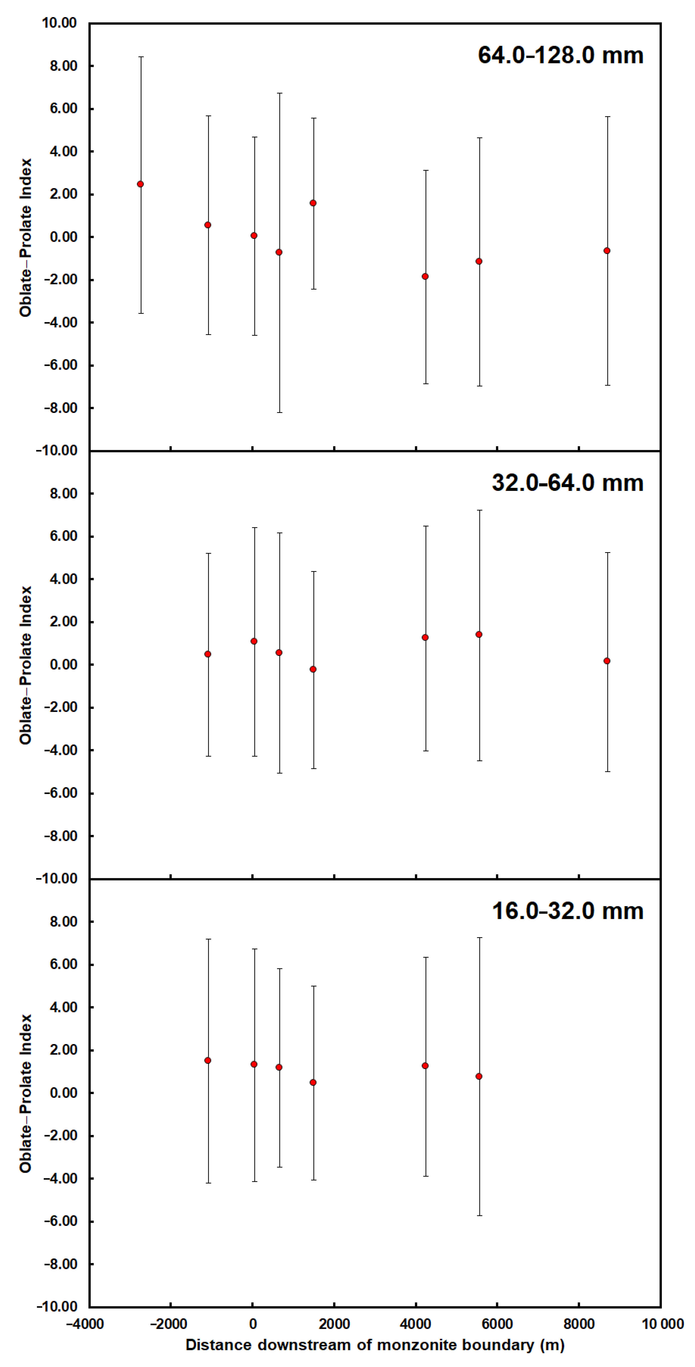
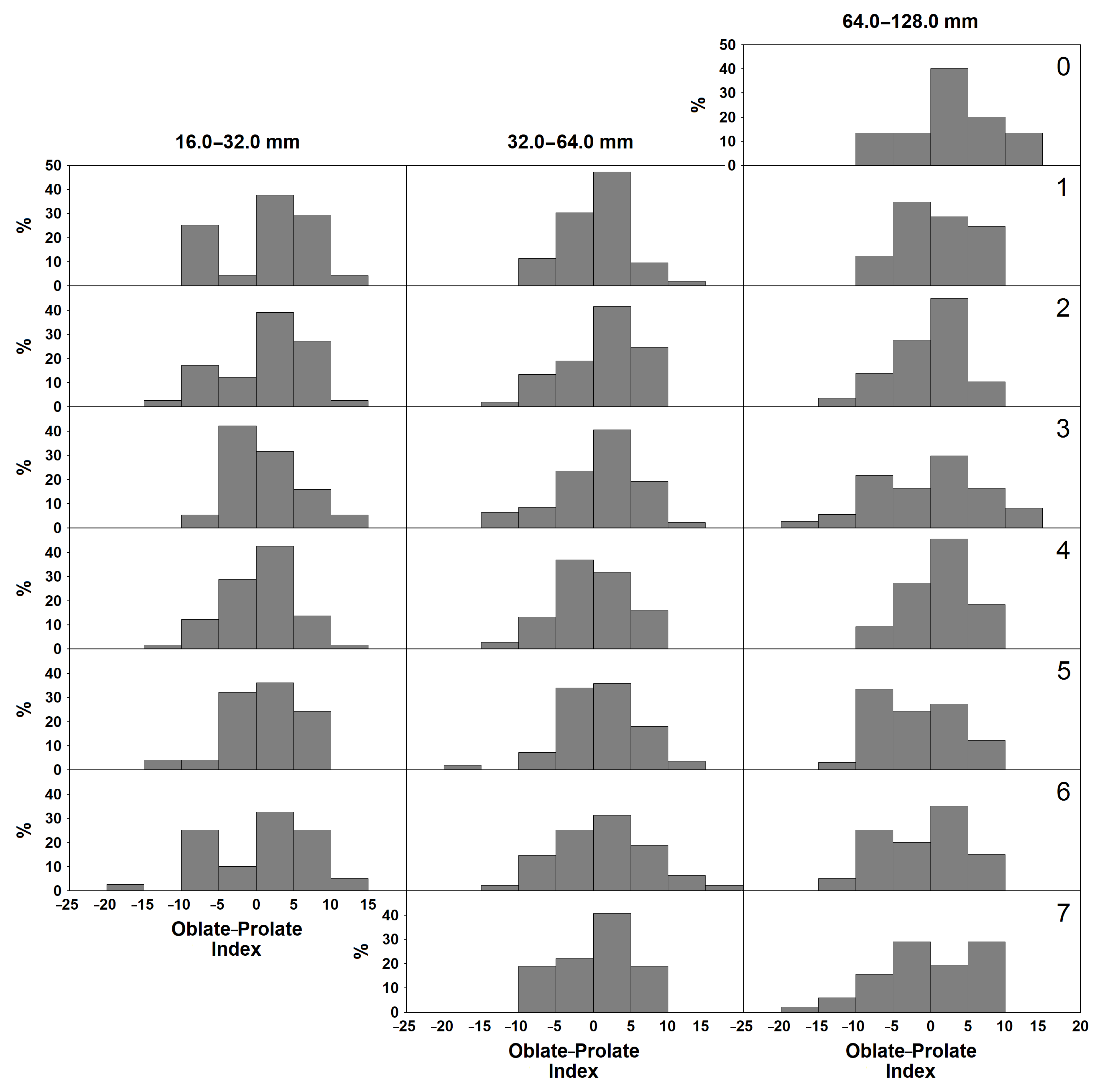
7.3. Downstream Changes in Gravel Oblate–Prolate Index

Studies of downstream changes in the Oblate–Prolate Index of fluvial gravels are rare. Ueki measured the form of granitic and sandstone gravels along the Doki River in Japan [81]. Whilst the granites displayed little change in O P ¯ along the channel, the O P ¯ of the sandstones generally decreased downstream. Dumitriu et al. studied downstream changes in O P ¯ along the Trotuş River in Romania [86]. Values varied considerably along the channel, with little evidence of any consistent downstream trend. However, their failure to restrict their analysis to isotropic lithologies may have obscured any pattern that their data may have possessed.
We are aware of only one investigation, that by Matthews, of changes in Oblate–Prolate Index as a result of laboratory attrition [83]. Matthews studied two lithologies (limestone and greywacke) and three size ranges (4.0–8.0, 8.0–16.0 and 16.0–32.0 mm). Apart from the large greywacke pebbles, whose mean properties changed little and whose values remained just negative, in all cases O P ¯ changed from zero or positive to negative during the experiments.

7.4. Downstream Changes in Oblate–Prolate Index along the Sabeto River

The general pattern of downstream change in mean O P ¯ along the Sabeto River is of decreasing values, though the trends are inconsistent and only approach statistical significance (p = 0.065) in the case of the 64.0–128.0 mm data set (Figure 16). Insofar as it’s possible to draw any conclusions from the limited and often inadequate data base of earlier work, this generally conforms with patterns observed elsewhere.
The possible downstream change in O P ¯ contrasts with the relative downstream stability in Ψp. It may be noteworthy that this echoes the patterns reported by Matthews in his laboratory study of downstream attrition [83]. Whereas values of Ψp changed little, all but one of his experimental runs recorded significant decreases in O P ¯ . Nevertheless, in the absence of additional and reliable studies, both from the field and the laboratory, it is impossible to judge whether these patterns are real and thus whether they support a model of the dominant role of attrition in the fluvial system.
The frequency-distribution plots of Oblate–Prolate Index at each of the sampling sites along the river are largely unimodal (Figure 17). A few of the distributions, however, display additional peaks in the O P ¯ < −5 range. We suggest that these are the product of clast breakage, which generates angular and platy (and thus low O P ¯ ) particles, a thesis supported by the significantly lower Rwt values of those particles of O P ¯ < −5 compared with those of O P ¯ > −5 at the 0.05 level (one-tailed Welch’s t-test, t = −2.2011, p = 0.0144 [88]). There is little evidence from the frequency-distribution plots that these discoidal particles are carried further downstream, though whether they are modified by attrition into more rodlike forms or whether they are lost by shape-sorting is not clear.
The Oblate–Prolate Index of the bedload gravels of the Sabeto River varies systematically as a function of roundness, increasing to a maximum at a roundness of 0.5–0.6 and decreasing thereafter (Figure 18). The orderly form of this relationship is suggestive of a causative association between roundness (and thus abrasion and its inverse, breakage) and O P ¯ .
Given that low O P ¯ particles appear to be dominantly angular and thus associated with breakage, we suggest that the direct relationship between O P ¯ and roundness that exists for Rwt < 0.5 is a result of the significance of breakage and spalling in the early part of the abrasion process [4,46]. However, once roundness exceeds ~0.5, the rounding process is dominated by grinding of the by-now relatively smooth particle surfaces and breakage becomes uncommon [46]. Domokos et al. have shown that, beyond this point, particle b/a ratios begin to increase consistently [17]. Since there is a close inverse relation between b/a and O P ¯ (Figure 19), we should expect O P ¯ to fall as roundness increases, mirroring the pattern shown in Figure 18. Interestingly, although his experimental results are largely missing from his paper, the abrasion experiments conducted on limestone gravels by Matthews appear to replicate the relationship described here between roundness and Oblate–Prolate Index [83].

8. Gravel Shape and Environmental Discrimination

One of the main aims of studies of particle shape has been to identify properties that may be used to distinguish the environmental conditions under which a clast was formed. Sames, for example, suggested that the roundness of river gravels is environmentally diagnostic and may be used as a means of discriminating fluvial from beach environments [89]. This proposition is apparently supported by the work of Dobkins and Folk [15]. On Tahiti Nui, the mean Modified Wentworth Roundness of river gravels (0.26–0.52) is less than that of low-energy beach gravels (0.34–0.61), which, in turn, is less than that of high-energy beach gravels (0.35–0.81). But the fluvial gravels studied by Dobkins and Folk had been transported only short distances and had not reached the limiting values of roundness observed in other studies (see Section 5.4). In longer rivers, as Dobkins and Folk recognised, the roundness of fluvial gravels would approach that of beach gravels [15]. In such circumstances, discrimination of fluvial and beach deposits on the basis of roundness alone would be difficult.
Nevertheless, Dobkins and Folk believed that other elements of the shape of fluvial gravels are so distinctive that they may be used to distinguish the environment of deposition of ancient conglomerates [15]. They considered that in most cases the measurement of either Maximum Projection Sphericity or Oblate–Prolate Index would be sufficient to discriminate between beach and fluvial environments, though for optimal distinction they recommended employing the two properties in combination. They proposed that, for isotropic gravels in the 16.0–256.0 mm size range, the mean sphericity of fluvial particles would exceed 0.65, whilst the mean Oblate–Prolate Index would exceed –1.5.
In the 50 years since this model was proposed, there has been only a handful of attempts to use this approach [90,91,92,93] and no critical assessment of the method. In an effort to evaluate the model, therefore, we have brought together the limited amount of data on the Maximum Projection Sphericity and Oblate–Prolate Index of isotropic fluvial gravels (Figure 20). The measurements have been made on a range of particles sizes (16.0–256.0 mm in the case of Dobkins and Folk’s data [15], 32.0–128.0 mm in the case of Howard’s data [51] and 16.0–32.0, 32.0–64.0 and 64.0–128.0 mm in the case of the data from this study) and on a variety of lithologies (basalt, quartzite, metavolcanic rocks and monzonite). Despite this, the values cluster tightly and conform closely with the environmental envelope proposed by Dobkins and Folk. It is beyond the scope of this study to compare the pattern displayed by fluvial gravels with those of particles from other environments. Nevertheless, whilst Dobkins and Folk argued that fluvial particles could be clearly discriminated from beach gravels using this method, we note that others had less confidence in the efficacy of the model [94].

9. Discussion and Conclusions

9.1. Introduction

Although the shape and origin of fluvial gravels have been studied for over a century, fundamental questions remain about how shapes evolve in the fluvial environment, what shapes tell us about sedimentary processes and whether particle shapes are environmentally diagnostic. This work has aimed to tackle these problems by drawing together and assessing existing information on fluvial gravel shape. At its crux, however, is the provision and interpretation of a large, high-quality set of measurements made on bedload gravels from the Sabeto River of western Viti Levu, Fiji. These have added appreciably to the existing corpus of information on fluvial gravel shape, whilst providing the opportunity for a much more sophisticated assessment of gravel shape and its determining factors than has previously been possible.

9.2. Roundness

In geologically straightforward situations and with mechanically coherent lithologies, the roundness of fluvial gravels increases as a function of the logarithm of distance downstream. However, the model of consistent and systematic downstream rounding implied by this is contradicted by the evidence from the upstream part of the Sabeto. Here, our observations show that, rather than primary material in its initial phase of rounding, the bulk of the 64.0–128.0 mm fraction has undergone at least one and perhaps more episodes of abrasion, fracturing and catastrophic size reduction. Instead of displaying an asymptotic pattern of downstream rounding, therefore, the route tracked by any individual particle is complex, with roundness following a saw-toothed pathway characterised by quasi-random reversals to an angular state.
In the case of the finer fractions, by contrast, fracturing is rare. This may be because larger particles possess momentum and thus experience preferential breakage as a result of collision with the channel boundary and one another. Because finer particles possess lower mass, breakage due to collision is uncommon. Despite this, the finer fractions receive the by-products of the fracturing of larger material. This effectively re-sets their roundness and maintains their angularity.
Although earlier workers denied the role of splitting in hydraulic environments, our observations indicate that not only is splitting common, but it is probably of critical importance in generating particle shapes in fluvial sediments. Although splitting is mainly restricted to cobble- and boulder-sized particles, its by-products filter down into finer fractions with the result that it plays a role in increasing angularity throughout the entire bedload size range.
Nevertheless, fracturing appears to become less common downstream. This may be because cobble- and boulder-sized material becomes infrequent with distance along the channel. As cobbles and boulders become scarcer, clast breakage becomes rarer, particle shape is not re-set and fewer angular by-products are generated. Additionally, river headwaters are dominated by cascade and step-pool channels. These are steep, with rough boundaries and coarse-grained bed material. The mobilisation of coarse sediments and their collision with channel boundaries during floods is likely to cause breakage and to generate angular particles. By contrast, the gentler reaches further downstream, often lined with finer sediment, may minimise the frequency of impacts and reduce the production of angular particles by breakage.
Although it has been argued that the roundness of fluvial gravels will increase downstream to an ultimate value of 1.0, limiting mean-roundness values of river gravels appear to lie in the range 0.63–0.74. Whilst individual gravels possess roundness values above these limits, the mean values are maintained by the presence of relatively angular particles even at downstream locations. Our data indicate that the occurrence of angular particles at downstream sites is unlikely to be because some particles round slowly and reach these locations in an angular state. Instead, the downstream re-appearance of angular particles is probably the result of particle splitting and the re-setting of the rounding clock. This continual process of roundness degradation means that, overall, the roundness population is likely to reach a dynamic equilibrium that lies far below the theoretical end point of 1.0. We venture that breakage is so common amongst particles of cobble grade in fluvial environments that it alone may be sufficient to prevent particle assemblages from reaching roundness values approaching 1.0.

9.3. Sphericity

Few reliable studies have been made of downstream changes in particle sphericity. Despite this, there is evidence that sphericity increases with distance, that it reaches a maximum, limiting value and that particle shape changes rapidly during the initial stages of transport. This means that either abrasion or shape sorting must occur almost immediately a particle enters the fluvial environment, with only ‘fluvially spherical’ shapes carried downstream to enter the sediment transport system.
It has been widely speculated that the sphere represents the end-product of fluvial transport. Nevertheless, although near-spherical particles have been generated under specific laboratory conditions, spherical or near-spherical gravels are rarely found in nature. Instead, isotropic lithologies appear to reach limiting mean-sphericities, with mean downstream values of Ψp from fluvial environments lying in the range 0.66–0.78.
Along the Sabeto, low sphericity particles have a dominantly angular form, though such particles are rapidly lost from the upstream part of the system. Although gravels of Ψp < 0.5 reappear downstream, these cannot represent the re-emergence of the primary shapes of the upstream sites and must instead be the product of downstream breakage.
The Sabeto data set displays no evidence of any relationship between particle size and sphericity, suggesting that differential shape-entrainment by fluid flow is relatively unimportant. Along the Sabeto, at least, therefore, it may be attrition rather than sorting that drives the sphericity of fluvial gravels. Support for this thesis comes from the systematic relationship between the roundness and sphericity of bedload gravels along the river. This suggests that that the development of sphericity is driven by attrition, with the positive relationship between roundness and sphericity supporting the suggestion that, whilst abrasion continues to add to the high sphericity fraction in the sediment, it is breakage that generates the low and continuing presence of low sphericity particles downstream.
One of the most notable observations of this and other studies of fluvial shape is the rapidity with which sphericity evolves downstream and the rapid transformation of particles to a ‘fluvial’ form. In the case of the Sabeto, it is unlikely that the downstream change from a ‘non-fluvial’ to a ‘fluvial’ form is a result of shape sorting and the consequent sequestration of non-spherical particles in either upstream or subsurface bed-sediment stores. In the absence of sorting, however, is attrition able to operate sufficiently speedily to modify particle form within a kilometre or so of gravel transport? Although we have no direct answer to this question, our roundness and breakage data suggest that the rapid modification of particle shape in the upstream part of the study reach is entirely feasible.
Although the weight of evidence from the Sabeto points to the dominant role of attrition in generating particle sphericity, this is not necessarily the case in other rivers. Bradley et al., for example, have argued convincingly that the downstream increase in Ψp along the Knik River must be a product of sorting [77]. We suggest instead that rivers exist along a sorting–attrition continuum, with the position of any individual river dependent on the range of particle sizes and shapes supplied to the system, on the operation or otherwise of differential size- and shape-sorting mechanisms, on the smoothness or roughness of the channel bed, and on the flow regime to which the sediment is exposed. These complexities may also explain the equivocal patterns of downstream change reported from fluvial systems worldwide, and the complex and variable relationships observed between sphericity and particle size.

9.4. Form

Despite its importance as a measure of particle shape, there have been very few attempts to determine the Oblate–Prolate Index of fluvial gravels. As a result, we know little of how O P ¯ varies with particle size or how O P ¯ changes downstream (though attrition experiments appear to suggest that values become progressively more negative), and we know little of the typical O P ¯ values of fluvial gravels, or whether indeed such values exist. Despite this, those few studies that provide reliable information on fluvial particle form yield remarkably similar numbers. Dobkins and Folk [15], who studied 16.0–256.0 mm basalt clasts on Tahiti Nui, obtained mean Oblate–Prolate Indices in the range –1.48 to 1.59 (n = 9). Howard [51] reported mean O P ¯ values on 32.0–128.0 mm quartzite and metavolcanic rocks of –1.20 to 2.12 (n = 22). And this study recorded mean values of O P ¯ of –1.88 to 1.55 (n = 20) on monzonite gravels in the size ranges 16.0–32.0, 32.0–64.0 and 64.0–128.0 mm.
These results raise an important question. If shape-sorting were the dominant control on the shape of fluvial gravels, we should expect particles to be sorted to maximise both Ψp and O P ¯ . Offsetting this in natural rivers may be particle breakage, which appears to operate to prevent Ψp from ever approaching 1.0 (see Section 6.6). But this does not explain why O P ¯ does not trend towards +∞, and thus to rodlike (and rollable) forms. One possibility is that there are geometric constraints that prevent the maximisation of the two indices. To assess this, we have compiled several thousand measurements on gravels from fluvial, beach and weathering environments (Figure 21). It is clear from these that natural particles possessing both high (>0.8) values of Ψp and high (>5) values of O P ¯ exist and that there are no numerical restrictions on their existence.
Perhaps, therefore, shape-sorting is not the dominant control on the form of fluvial gravels. There is some evidence, for example, that rather than tending to a highly rollable form, fluvial gravels are abraded to negative values of O P ¯ [83]. Unfortunately, corroborative data are rare. The few studies of downstream change in O P ¯ are inconclusive and we are unaware of any evidence that the O P ¯ of fluvial gravels evolves to an ultimate limiting state.
The Oblate–Prolate Index of the bedload gravels of the Sabeto River varies as a function of roundness, increasing to a maximum at a roundness of 0.5–0.6 and decreasing thereafter. The systematic form of this relationship is suggestive of a causative association between roundness (and thus breakage and abrasion) and O P ¯ . More particularly, it implies that the ultimate decrease in O P ¯ is a direct consequence of the abrasion process, which sees a consistent increase in b/a ratios once roundness reaches ~0.5 and the rounding process becomes dominated by the grinding of particle surfaces rather than by the removal of angular corners.

9.5. Gravel Shape and Environmental Discrimination

In 1970, Dobkins and Folk proposed that the Maximum Projection Sphericity and Oblate–Prolate Index of fluvial gravels are so distinctive that they may be used, alone or in combination, to discriminate the environment of deposition of ancient conglomerates [15]. In the 50 years since then, however, the method has been almost entirely overlooked: the model has rarely been employed and it has escaped critical assessment. Some measure of this may be gathered from the limited number of fluvial data sets that exist that are suitable for testing their model. Notwithstanding this limitation, we have brought these together and assessed them using the O P ¯ Ψp approach. The measurements were made on a range of particle sizes and on a range of lithologies. Despite this, the values cluster tightly on the O P ¯ Ψp plot and conform closely with the environmental envelope established by Dobson and Folk.

Funding

This research received no external funding.

Institutional Review Board Statement

Not applicable.

Informed Consent Statement

Not applicable.

Data Availability Statement

The raw and processed measurements are available at Mendeley Data, V1, doi:10.17632/gwnfv4c6b5.1 [36].

Acknowledgments

I am very grateful to Professor Marwan Hassan and his research group at the University of British Columbia for their thoughtful comments on an earlier version of this paper.

Conflicts of Interest

The author declares no conflict of interest.

References

  1. Forster, E.S. Mechanica. In The Works of Aristotle Translated into English under the Editorship of W. D. Ross M.A. Fellow and Tutor of Oriel College Volume VI Opuscula; Loveday, T., Forster, E.S., Dowdall, L.D., Joachim, H.H.; Clarendon Press: Oxford, UK, 1913; pp. 847–858. [Google Scholar]
  2. Freeman, K. Ancilla to the Pre-Socratic Philosophers a Complete Translation of the Fragments in Diels; Fragmente der Vorsokratiker; Basil Blackwell: Oxford, UK, 1948; 162p. [Google Scholar]
  3. Wentworth, C.K. A laboratory and field study of cobble abrasion. J. Geol. 1919, 27, 507–521. [Google Scholar] [CrossRef] [Green Version]
  4. Krumbein, W.C. The effects of abrasion on the size, shape and roundness of rock fragments. J. Geol. 1941, 49, 482–520. [Google Scholar] [CrossRef]
  5. Krumbein, W.C. Measurement and geological significance of shape and roundness of sedimentary particles. J. Sediment. Petrol. 1941, 11, 64–72. [Google Scholar] [CrossRef]
  6. Rayleigh. The ultimate shape of pebbles, natural and artificial. Proc. R. Soc. 1942, 181A, 107–118. [Google Scholar]
  7. Rayleigh. Pebbles, natural and artificial their shape under various conditions of abrasion. Proc. R. Soc. 1944, 182A, 321–335. [Google Scholar]
  8. Rayleigh. Pebbles of regular shape, and their reproduction in experiment. Nature 1944, 154, 169–171. [Google Scholar] [CrossRef] [Green Version]
  9. Kuenen, P.H. Water faceted boulders. Am. J. Sci. 1947, 245, 779–783. [Google Scholar] [CrossRef]
  10. Kuenen, P.H. Experimental abrasion of pebbles 2. Rolling by current. J. Geol. 1956, 64, 336–368. [Google Scholar] [CrossRef]
  11. Kuenen, P.H. Experimental abrasion: 6. Surf action. Sedimentology 1964, 3, 29–43. [Google Scholar] [CrossRef]
  12. Folk, R.L. Student operator error in determination of roundness, sphericity, and grain size. J. Sediment. Petrol. 1955, 25, 297–301. [Google Scholar]
  13. Folk, R.L. Experimental error in pebble roundness determination by the modified Wentworth method. J. Sediment. Petrol. 1972, 42, 973–974. [Google Scholar]
  14. Sneed, E.D.; Folk, R.L. Pebbles in the lower Colorado River, Texas a study in particle morphogenesis. J. Geol. 1958, 66, 114–150. [Google Scholar] [CrossRef]
  15. Dobkins, J.E.; Folk, R.L. Shape development on Tahiti-Nui. J. Sediment. Petrol. 1970, 40, 1167–1203. [Google Scholar]
  16. Durian, D.J.; Bideaud, H.; Duringer, P.; Schröder, A.; Thalmann, F.; Marques, C.M. What is in a pebble shape? Phys. Rev. Lett. 2006, 97, 028001. [Google Scholar] [CrossRef] [Green Version]
  17. Domokos, G.; Jerolmack, D.J.; Sipos, A.Á.; Török, Á. How river rocks round: Resolving the shape-size paradox. PLoS ONE 2014, 9, e88657. [Google Scholar]
  18. Novák-Szabó, T.; Sipos, A.Á.; Shaw, S.; Bertoni, D.; Pozzebon, A.; Grottoli, E.; Sarti, G.; Ciavola, P.; Domokos, G.; Jerolmack, D.J. Universal characteristics of particle shape evolution by bed-load chipping. Sci. Adv. 2018, 4, eaao4946. [Google Scholar] [CrossRef] [PubMed] [Green Version]
  19. Kelly, P.A. Roundness in river and beach pebbles: A review of recent research with some implications for schools’ fieldwork. Geography 1983, 68, 25–30. [Google Scholar]
  20. Gale, S.J.; Hoare, P.G. Quaternary Sediments: Petrographic Methods for the Study of Unlithified Rocks, 2nd ed.; Blackburn Press: Caldwell, NJ, USA, 2011; Volume xlv + 325p. [Google Scholar]
  21. Flemming, N.C. Form and function of sedimentary particles. J. Sediment. Petrol. 1965, 35, 381–390. [Google Scholar] [CrossRef]
  22. Barrett, P.J. The shape of rock particles, a critical review. Sedimentology 1980, 27, 291–303. [Google Scholar] [CrossRef]
  23. Blott, S.J.; Pye, K. Particle shape: A review and new methods of characterization and classification. Sedimentology 2008, 55, 31–63. [Google Scholar] [CrossRef]
  24. Wadell, H. Volume, shape, and roundness of rock particles. J. Geol. 1932, 40, 443–451. [Google Scholar] [CrossRef]
  25. Wadell, H. Sphericity and roundness of rock particles. J. Geol. 1933, 41, 310–331. [Google Scholar] [CrossRef]
  26. Griffiths, J.C. Scientific Method in Analysis of Sediments; McGraw-Hill: New York, NY, USA, 1967; 508p. [Google Scholar]
  27. Wentworth, C.K. A method of measuring and plotting the shapes of pebbles. U.S. Geol. Surv. Bull. 1922, 730-C, 91–102. [Google Scholar]
  28. Cassel, M.; Lavé, J.; Recking, A.; Malavoi, J.-R.; Piégay, H. Bedload transport in rivers, size matters but so does shape. Sci. Rep. 2021, 11, 508. [Google Scholar] [CrossRef]
  29. Rao, B. Geology of Lautoka Area; Viti Levu Sheet 4; 1:50,000 Scale Geological Sheet; Mineral Resources Department: Suva, Fiji, 1983.
  30. Hathway, B. The Nadi Basin: Neogene strike-slip faulting and sedimentation in a fragmented arc, western Viti Levu, Fiji. J. Geol. Soc. Lond. 1993, 150, 563–581. [Google Scholar] [CrossRef]
  31. Rodda, P. Ages of Stratigraphic Units, 2nd ed.; Mineral Resources Department: Suva, Fiji, in press; 32p.
  32. Gale, S.J.; Ibrahim, Z.Z.; Lal, J.; Sicinilawa, U.B.T. Downstream fining in a megaclast-dominated fluvial system: The Sabeto River of western Viti Levu, Fiji. Geomorphology 2019, 330, 151–162. [Google Scholar] [CrossRef]
  33. Köppen, W.P. Das geographische system der klimate. In Handbuch der Klimatologie Band 1, Teil C; Köppen, W.P., Geiger, R., Eds.; Gebrüder Borntraeger: Berlin, Germany, 1936; 44p. [Google Scholar]
  34. McGree, S.; Yeo, S.W.; Devi, S. Flooding in the Fiji Islands between 1840 and 2009; Risk Frontiers Technical Report; Risk Frontiers, Macquarie University: Sydney, New South Whales, Australia, 2010; 69p. [Google Scholar]
  35. Tonkin & Taylor. Vulani Island Resort Coastal Process and River Assessment; Report Prepared for Vulani Island Ltd.; Tonkin & Taylor Ltd: Auckland, New Zealand, 2007; 49p + 7 drawings + 5 appendices. [Google Scholar]
  36. Ibrahim, Z.Z.; Gale, S.J. The shape of fluvial bedload gravels: A large, high-quality data set of active-channel deposits. Data Brief 2021, in press. [Google Scholar]
  37. Wentworth, C.K. A scale of grade and class terms for clastic sediments. J. Geol. 1922, 30, 377–392. [Google Scholar] [CrossRef]
  38. Williams, R.M.E.; Grotzinger, J.P.; Dietrich, W.E.; Gupta, S.; Sumner, D.Y.; Wiens, R.C.; Mangold, N.; Malin, M.C.; Edgett, K.S.; Maurice, S.; et al. Martian fluvial conglomerates at Gale Crater. Science 2013, 340, 1068–1072. [Google Scholar] [CrossRef]
  39. Schumm, S.A.; Stevens, M.A. Abrasion in place: A mechanism for rounding and size reduction of coarse sediments in rivers. Geology 1973, 1, 37–40. [Google Scholar] [CrossRef]
  40. Bluck, B.J. Particle rounding in beach gravels. Geol. Mag. 1969, 106, 1–14. [Google Scholar] [CrossRef]
  41. Bradley, W.C. Effect of weathering on abrasion of granitic gravel, Colorado River (Texas). Geol. Soc. Am. Bull. 1970, 81, 61–80. [Google Scholar] [CrossRef]
  42. Jones, L.S.; Humphrey, N.F. Weathering-controlled abrasion in a coarse-grained, meandering reach of the Rio Grande: Implications for the rock record. Geol. Soc. Am. Bull. 1997, 109, 1080–1088. [Google Scholar] [CrossRef]
  43. Heller, P.L.; Beland, P.E.; Humphrey, N.F.; Konrad, S.K.; Lynds, R.M.; McMillan, M.E.; Valentine, K.E.; Widman, Y.A.; Furbish, D.J. Paradox of downstream fining and weathering-rind formation in the lower Hoh River, Olympic Peninsula, Washington. Geology 2001, 29, 971–974. [Google Scholar] [CrossRef]
  44. Hemmingsen, M.A. Reduction of Greywacke Sediments on the Canterbury Bight Coast, South Island, New Zealand. Ph.D. Thesis, University of Canterbury, Christchurch, New Zealand, 2004. [Google Scholar]
  45. Mills, H.H. Downstream rounding of pebbles—A quantitative review. J. Sediment. Petrol. 1979, 49, 295–302. [Google Scholar]
  46. Wentworth, C.K. A field study of the shapes of river pebbles. U.S. Geol. Surv. Bull. 1922, 730-C, 103–114. [Google Scholar]
  47. Domokos, G.; Kun, F.; Sipos, A.Á.; Szabó, T. Universality of fragment shapes. Sci. Rep. 2015, 5, 9147. [Google Scholar] [CrossRef] [Green Version]
  48. Montgomery, D.R.; Buffington, J.M. Channel-reach morphology in mountain drainage basins. Geol. Soc. Am. Bull. 1997, 109, 596–611. [Google Scholar] [CrossRef]
  49. Plumley, W.J. Black Hills terrace gravels: A study in sediment transport. J. Geol. 1948, 56, 526–577. [Google Scholar] [CrossRef]
  50. Miller, K.L.; Szabó, T.; Jerolmack, D.J.; Domokos, G. Quantifying the significance of abrasion and selective transport for downstream fluvial grain size evolution. J. Geophys. Res. Earth Surf. 2014, 119, 2412–2429. [Google Scholar] [CrossRef] [Green Version]
  51. Howard, J.L. An evaluation of shape indices as palaeoenvironmental indicators using quartzite and metavolcanic clasts in Upper Cretaceous to Palaeogene beach, river and submarine fan conglomerates. Sedimentology 1992, 39, 471–486. [Google Scholar] [CrossRef]
  52. Tricart, J.; Schaeffer, R. L’indice d’émoussé des galets, moyen d’étude des systèmes d’érosion. Rev. Géomorphol. Dynam. 1950, 4, 151–179. [Google Scholar]
  53. Oak, H.L. The boulder beach: A fundamentally distinct sedimentary assemblage. Ann. Assoc. Am. Geogr. 1984, 74, 71–82. [Google Scholar] [CrossRef]
  54. Malarz, R. Effects of flood abrasion of the Carpathian alluvial gravels. Catena 2005, 64, 1–26. [Google Scholar] [CrossRef]
  55. Lewin, J.; Brewer, P.A. Laboratory simulation of clast abrasion. Earth Surf. Process. Landf. 2002, 27, 145–164. [Google Scholar] [CrossRef]
  56. Bretz, J H. Valley deposits immediately east of the channeled scabland of Washington. II. J. Geol. 1929, 37, 505–541. [Google Scholar] [CrossRef]
  57. Sarmiento, A. Experimental Study of Pebble Abrasion. Master’s Thesis, University of Chicago, Chicago, IL, USA, 1945. [Google Scholar]
  58. Marshall, P. Beach gravels and sands. Trans. Proc. N.Z. Inst. 1929, 60, 324–365, Cited in [59]. [Google Scholar]
  59. Pettijohn, F.J. Sedimentary Rocks; Harper & Brothers: New York, NY, USA, 1949; 526p. [Google Scholar]
  60. Sternberg, H. Untersuchungen über Längen- und Querprofil geschiebeführender Flüsse. Z. Bauwesen 1875, 25, 483–506. [Google Scholar]
  61. Krumbein, W.C. Settling-velocity and flume-behavior of non-spherical particles. Trans. Am. Geophys. Union 1942, 23, 621–633. [Google Scholar] [CrossRef]
  62. Lane, E.W.; Carlson, E.J. Some observations on the effect of particle shape on the movement of coarse sediments. Trans. Am. Geophys. Union 1954, 35, 453–462. [Google Scholar] [CrossRef]
  63. Ashworth, P.J.; Ferguson, R.I. Size-selective entrainment of bed load in gravel bed streams. Water Resour. Res. 1989, 25, 627–634. [Google Scholar] [CrossRef]
  64. Hattingh, J.; Illenberger, W.K. Shape sorting of flood-transported synthetic clasts in a gravel bed river. Sediment. Geol. 1995, 96, 181–190. [Google Scholar] [CrossRef]
  65. Schmidt, K.-H.; Ergenzinger, P. Bedload entrainment, travel lengths, step lengths, rest periods—studied with passive (iron, magnetic) and active (radio) tracer techniques. Earth Surf. Process. Landf. 1992, 17, 147–165. [Google Scholar] [CrossRef]
  66. Stott, T.A.; Sawyer, A. Clast travel distances and abrasion rates in two coarse upland channels determined using magnetically tagged bedload. In Tracers in Geomorphology; Foster, I.D.L., Ed.; John Wiley: Chichester, UK, 2000; pp. 389–399. [Google Scholar]
  67. Carling, P.A.; Kelsey, A.; Glaister, M.S. Effect of bed roughness, particle shape and orientation on initial motion criteria. In Dynamics of Gravel-Bed Rivers; Billi, P., Hey, R.D., Thorne, C.R., Tacconi, P., Eds.; John Wiley: Chichester, UK, 1992; pp. 23–39. [Google Scholar]
  68. Demir, T. The Influence of Particle Shape on Bedload Transport in Coarse-Bed River Channels. Ph.D. Thesis, University of Durham, Durham, UK, 2000. [Google Scholar]
  69. Schmidt, K.-H.; Gintz, D. Results of bedload tracer experiments in a mountain river. In River Geomorphology; Hickin, E.J., Ed.; John Wiley: Chichester, UK, 1995; pp. 37–54. [Google Scholar]
  70. Parker, G.; Klingeman, P.C.; McLean, D.G. Bedload and size distribution in paved gravel-bed streams. J. Hydraul. Div. Proc. Am. Soc. Civ. Eng. 1982, 108, 544–571. [Google Scholar]
  71. Andrews, E.D. Entrainment of gravel from naturally sorted riverbed material. Geol. Soc. Am. Bull. 1983, 94, 1225–1231. [Google Scholar] [CrossRef]
  72. Southard, J.B. Introduction to Fluid Motions, Sediment Transport, and Current-Generated Sedimentary Structures; MIT OpenCourseWare, Massachusetts Institute of Technology: Cambridge, MA, USA, 2006; Volume 536 + 3p. [Google Scholar]
  73. Mao, L.; Surian, N. Observations on sediment mobility in a large gravel-bed river. Geomorphology 2010, 114, 326–337. [Google Scholar] [CrossRef]
  74. Ibbeken, H.; Schleyer, R. Source and Sediment a Case Study of Provenance and Mass Balance at an Active Plate Margin (Calabria, Southern Italy); Springer: Berlin, Germany, 1991; 286p. [Google Scholar]
  75. Allen, P. Wealden petrology: The Top Ashdown Pebble Bed and the Top Ashdown Sandstone. Q. J. Geol. Soc. 1948, 104, 257–321. [Google Scholar] [CrossRef]
  76. Carroll, D. Pebbles from a pothole: A study in shape and roundness. J. Sediment. Petrol. 1951, 21, 205–212. [Google Scholar]
  77. Bradley, W.C.; Fahnestock, R.K.; Rowekamp, E.T. Coarse sediment transport by flood flows on Knik River, Alaska. Geol. Soc. Am. Bull. 1972, 83, 1261–1284. [Google Scholar] [CrossRef]
  78. Glover, B.K. A morphometric analysis of terrace gravels in Santa Ynez basin, Santa Barbara County, California. Sediment. Geol. 1975, 13, 109–124. [Google Scholar] [CrossRef]
  79. Krumbein, W.C. Flood deposits of Arroyo Seco, Los Angeles County, California. Bull. Geol. Soc. Am. 1942, 53, 1355–1402. [Google Scholar] [CrossRef]
  80. Unrug, R. Współczesny transport i sedymentacja żwirów w dolinie Dunajca. Acta Geol. Pol. 1957, 7, 217–258. [Google Scholar]
  81. Ueki, T. Downstream variation in particle size, form, roundness, and lithology: A case study of the Doki River, southwest Japan. Geogr. Rep. Tokyo Metrop. Univ. 1999, 34, 1–24. [Google Scholar]
  82. Goede, A. Pebble Morphometry of the Tambo River, Eastern Victoria. Master’s Thesis, University of Tasmania, Hobart, Tasmania, Australia, 1972. [Google Scholar]
  83. Matthews, E.R. Measurements of beach pebble attrition in Palliser Bay, southern North Island, New Zealand. Sedimentology 1983, 30, 787–799. [Google Scholar] [CrossRef]
  84. Bluck, B.J. Sedimentation of an alluvial fan in southern Nevada. J. Sediment. Petrol. 1964, 34, 395–400. [Google Scholar]
  85. Moriyama, A.; Nakanishi, T. Grain form characteristics and fabric orientation of pebbles in alluvial rivers. Trans. Jpn. Geomorphol. Union 1991, 12, 335–355. [Google Scholar]
  86. Dumitriu, D.; Niculiţă, M.; Condorachi, D. Downstream variation in the pebble morphometry of the Trotuş River, Eastern Carpathians (Romania). Forum Geogr. 2011, 10, 78–90. [Google Scholar] [CrossRef]
  87. Lindholm, R.C. A Practical Approach to Sedimentology; Allen & Unwin: London, UK, 1987; 276p. [Google Scholar]
  88. Ruxton, G.D. The unequal variance t-test is an underused alternative to Student’s t-test and the Mann–Whitney U test. Behav. Ecol. 2006, 17, 688–690. [Google Scholar] [CrossRef]
  89. Sames, C.W. Morphometric data of some recent pebble associations and their application to ancient deposits. J. Sediment. Petrol. 1966, 36, 126–142. [Google Scholar]
  90. Smale, D. The composition of a Torlesse conglomerate—Ethelton, north Canterbury. N.Z. J. Geol. Geophys. 1978, 21, 699–711. [Google Scholar] [CrossRef] [Green Version]
  91. Russell, T. Use of clast shape in determining the sedimentary history of the Late Devonian Keepit Conglomerate, Australia. Sediment. Geol. 1980, 25, 277–290. [Google Scholar] [CrossRef]
  92. Els, B.G. Pebble morphology of an ancient conglomerate: The Middelvlei gold placer, Witwatersrand, South Africa. J. Sediment. Petrol. 1988, 58, 894–901. [Google Scholar]
  93. Widera, M. The morphology of fossil pebbles as a tool for determining their transport processes (Koźmin South lignite open-cast pit, central Poland). Ann. Soc. Geol. Pol. 2010, 80, 315–325. [Google Scholar]
  94. Hart, B.S. A study of pebble shape from gravelly shoreface deposits. Sediment. Geol. 1991, 73, 185–189. [Google Scholar] [CrossRef]
  95. Gale, S.J. The shape of beach gravels. J. Sediment. Petrol. 1990, 60, 787–789. [Google Scholar] [CrossRef]
  96. Jones, B.G.; Hunter, I.G. Very large boulders on the coast of Grand Cayman: The effects of giant waves on rocky coastlines. J. Coast. Res. 1992, 8, 763–774. [Google Scholar]
  97. Bryant, E.A.; Haslett, S.K. Catastrophic wave erosion, Bristol Channel, United Kingdom: Impact of tsunami? J. Geol. 2007, 115, 253–269. [Google Scholar] [CrossRef] [Green Version]
  98. Kennedy, D.M.; Tannock, K.L.; Crozier, M.J.; Rieser, U. Boulders of MIS 5 age deposited by a tsunami on the coast of Otago, New Zealand. Sediment. Geol. 2007, 200, 222–231. [Google Scholar] [CrossRef]
Figure 1. The drainage and catchment of the Sabeto River of western Viti Levu, Fiji, showing the location of the sampling sites. Modified from Gale et al. [32].
Geosciences 11 00161 g001
Figure 2. The geology of the catchment of the Sabeto River of western Viti Levu, Fiji, showing the location of the sampling sites. Modified from Gale et al. [32].
Geosciences 11 00161 g002
Figure 3. The mean Modified Wentworth Roundness of gravels of Navilawa Monzonite as a function of distance downstream of the boundary of the monzonite intrusion in the Sabeto River of western Viti Levu, Fiji. The data points are expressed with an uncertainty of ±1 s. The regression lines represent the results of the application of a semi-logarithmic model to the data using least-squares regression. The coefficients of determination (r2) associated with each model are as follows: 16.0–32.0 mm = 0.862, 32.0–64.0 mm = 0.693, 64.0–128.0 mm = 0.887.
Geosciences 11 00161 g003
Figure 4. The frequency distribution of the Modified Wentworth Roundness of gravels of Navilawa Monzonite within the 16.0–32.0, 32.0–64.0 and 64.0–128.0 mm fractions from Stations 0–7 along the Sabeto River of western Viti Levu, Fiji.
Geosciences 11 00161 g004
Figure 5. The b/a and c/a axis ratios of freshly weathered gravels of Navilawa Monzonite from the Sabeto River valley of western Viti Levu, Fiji as a function of particle a-axis length. The two sub-parallel lines represent the best-fit models of Domokos et al. [47], corresponding to the claimed shapes of particles generated by weathering, impact and explosion.
Geosciences 11 00161 g005
Figure 6. The incidence of broken rounds as a function of particle size in fluvial gravels of Navilawa Monzonite at Station 1 in the Sabeto River of western Viti Levu, Fiji.
Geosciences 11 00161 g006
Figure 7. The Sabeto River of western Viti Levu, Fiji: (A) a low gradient, plane-bed reach 0.1 km upstream of Station 1, (B) the change from steep, headwater, step-pool conditions to gentle, downstream plane-bed conditions 0.2 km upstream of Station 1 and (C) the steep, cascade conditions characteristic of the river’s headwaters.
Geosciences 11 00161 g007
Figure 8. The incidence of broken rounds as a function of particle size in beach gravels on Lennox Head Beach, northern New South Wales, Australia. Note that the broken rounds are the products of splitting; the process itself is thus likely to be of greatest importance in the >181.0 mm fractions.
Geosciences 11 00161 g008
Figure 9. The Maximum Projection Sphericity of fluvial gravels of Navilawa Monzonite from Stations 1–7 along the Sabeto River of western Viti Levu, Fiji as a function of particle b-axis length.
Geosciences 11 00161 g009
Figure 10. The mean Maximum Projection Sphericity of gravels of Navilawa Monzonite as a function of distance downstream of the boundary of the monzonite intrusion in the Sabeto River of western Viti Levu, Fiji. The data points are expressed with an uncertainty of ±1 s.
Geosciences 11 00161 g010
Figure 11. The frequency distribution of the Maximum Projection Sphericity of gravels of Navilawa Monzonite within the 16.0–32.0, 32.0–64.0 and 64.0–128.0 mm fractions from Stations 0–7 along the Sabeto River of western Viti Levu, Fiji.
Geosciences 11 00161 g011
Figure 12. The Maximum Projection Sphericity of fluvial gravels of Navilawa Monzonite from Stations 1–7 along the Sabeto River of western Viti Levu, Fiji as a function of their Modified Wentworth Roundness. The data points are expressed with an uncertainty of ±1 s.
Geosciences 11 00161 g012
Figure 13. The Maximum Projection Sphericity of fluvial gravels of Navilawa Monzonite at Stations 1–7 along the Sabeto River of western Viti Levu, Fiji as a function of their Modified Wentworth Roundness. The data points are expressed with an uncertainty of ±1 s.
Geosciences 11 00161 g013
Figure 14. The Oblate–Prolate Index and Maximum Projection Sphericity of fluvial gravels of Navilawa Monzonite from Stations 1–7 along the Sabeto River of western Viti Levu, Fiji.
Geosciences 11 00161 g014
Figure 15. The Oblate–Prolate Index of fluvial gravels of Navilawa Monzonite from Stations 1–7 along the Sabeto River of western Viti Levu, Fiji as a function of particle b-axis length.
Geosciences 11 00161 g015
Figure 16. The mean Oblate–Prolate Index of gravels of Navilawa Monzonite as a function of distance downstream of the boundary of the monzonite intrusion in the Sabeto River of western Viti Levu, Fiji. The data points are expressed with an uncertainty of ±1 s.
Geosciences 11 00161 g016
Figure 17. The frequency distribution of the Oblate–Prolate Index of gravels of Navilawa Monzonite within the 16.0–32.0, 32.0–64.0 and 64.0–128.0 mm fractions from Stations 0–8 along the Sabeto River of western Viti Levu, Fiji.
Geosciences 11 00161 g017
Figure 18. The Oblate–Prolate Index of fluvial gravels of Navilawa Monzonite from Stations 1–7 along the Sabeto River of western Viti Levu, Fiji as a function of their Modified Wentworth Roundness. The data points are expressed with an uncertainty of ±1 s.
Geosciences 11 00161 g018
Figure 19. The Oblate–Prolate Index and b/a axis ratio of fluvial gravels of Navilawa Monzonite from Stations 1–7 along the Sabeto River of western Viti Levu, Fiji.
Geosciences 11 00161 g019
Figure 20. The mean Oblate–Prolate Index and mean Maximum Projection Sphericity of fluvial gravels from Tahiti Nui [15], Californian Paleogene deposits [51] and the Sabeto River, Fiji (this study).
Geosciences 11 00161 g020
Figure 21. The Oblate–Prolate Index and Maximum Projection Sphericity of 3171 gravels from fluvial, beach, tsunami and weathering environments. Source of data: Gale [95], Jones and Hunter [96], Bryant and Haslett [97], Kennedy et al. [98] and unpublished measurements.
Geosciences 11 00161 g021
Table 1. Mean Values of Maximum Projection Sphericity from Isotropic Fluvial Gravels Taken from Downstream Locations.
Mean Maximum Projection SphericityLithologyParticle Size (mm)Source
0.714Quartz30.0–70.0 (a-axis)[14]
0.725Aplite16.0–64.0 (b-axis)[41]
0.687Basalt16.0–32.0[15]
0.696Basalt32.0–64.0[15]
0.697Basalt64.0–128.0[15]
0.67–0.74Quartz16.0–64.0[15]
0.70–0.78Quartzite32.0–128.0 (b-axis)[51]
0.66–0.75Metavolcanic rock32.0–128.0 (b-axis)[51]
Publisher’s Note: MDPI stays neutral with regard to jurisdictional claims in published maps and institutional affiliations.

