
Defining the Geotourism Potential of the CILENTO, Vallo di Diano and Alburni UNESCO Global Geopark (Southern Italy)

 ,
,  , ,
, ,  and
and 
Abstract
:1. Introduction
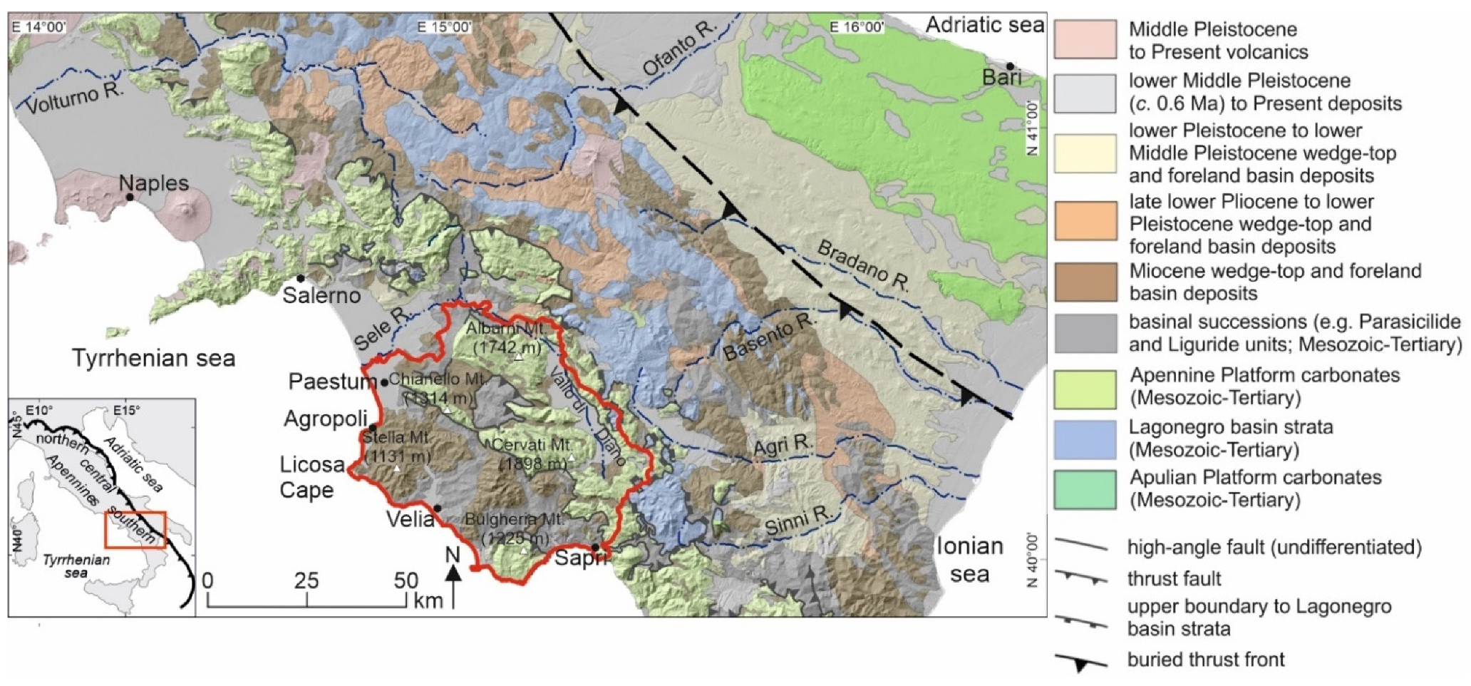
2. Geological Setting of the Cilento, Vallo di Diano and Alburni Geopark
3. Methods
4. Results
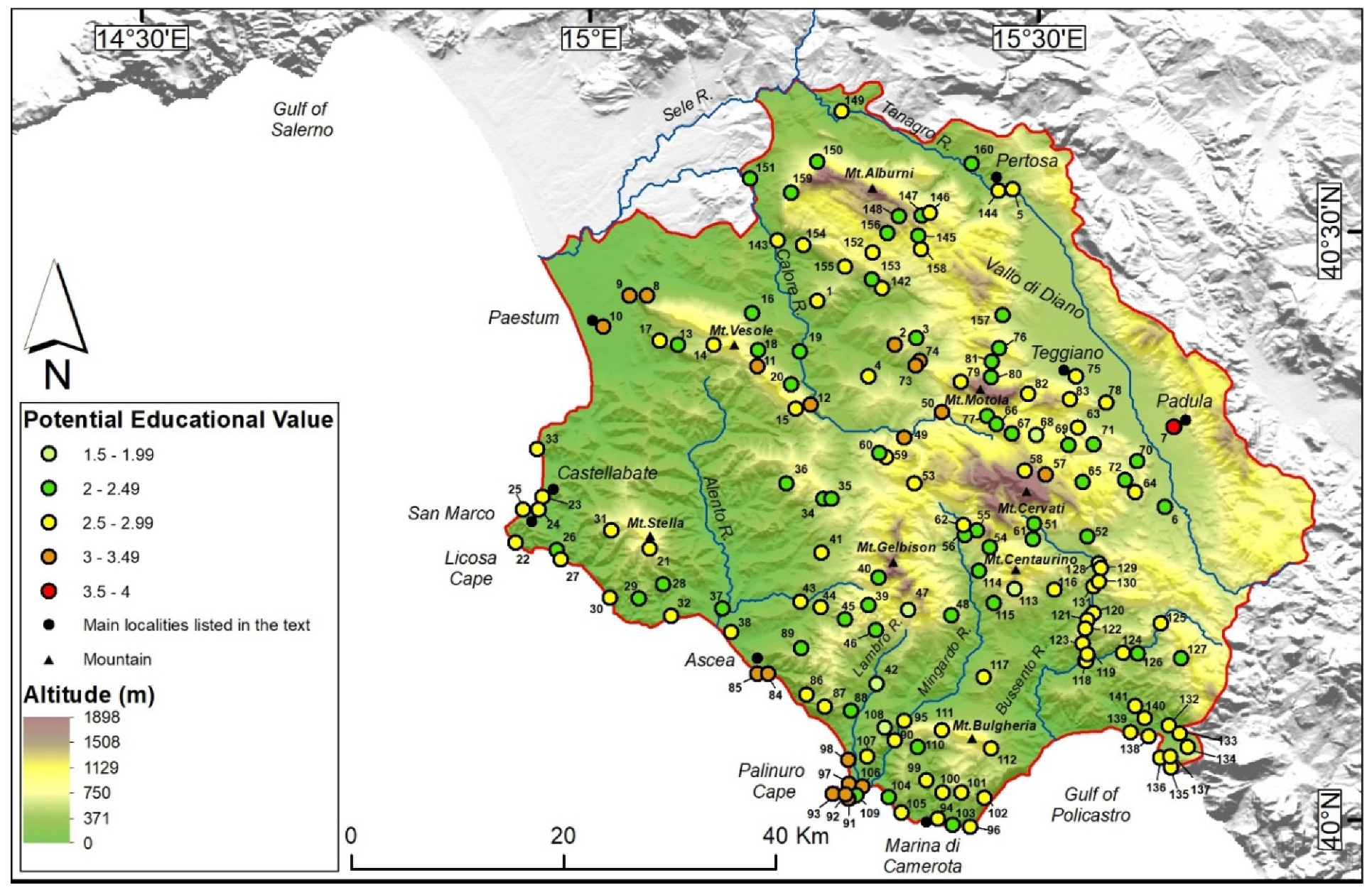
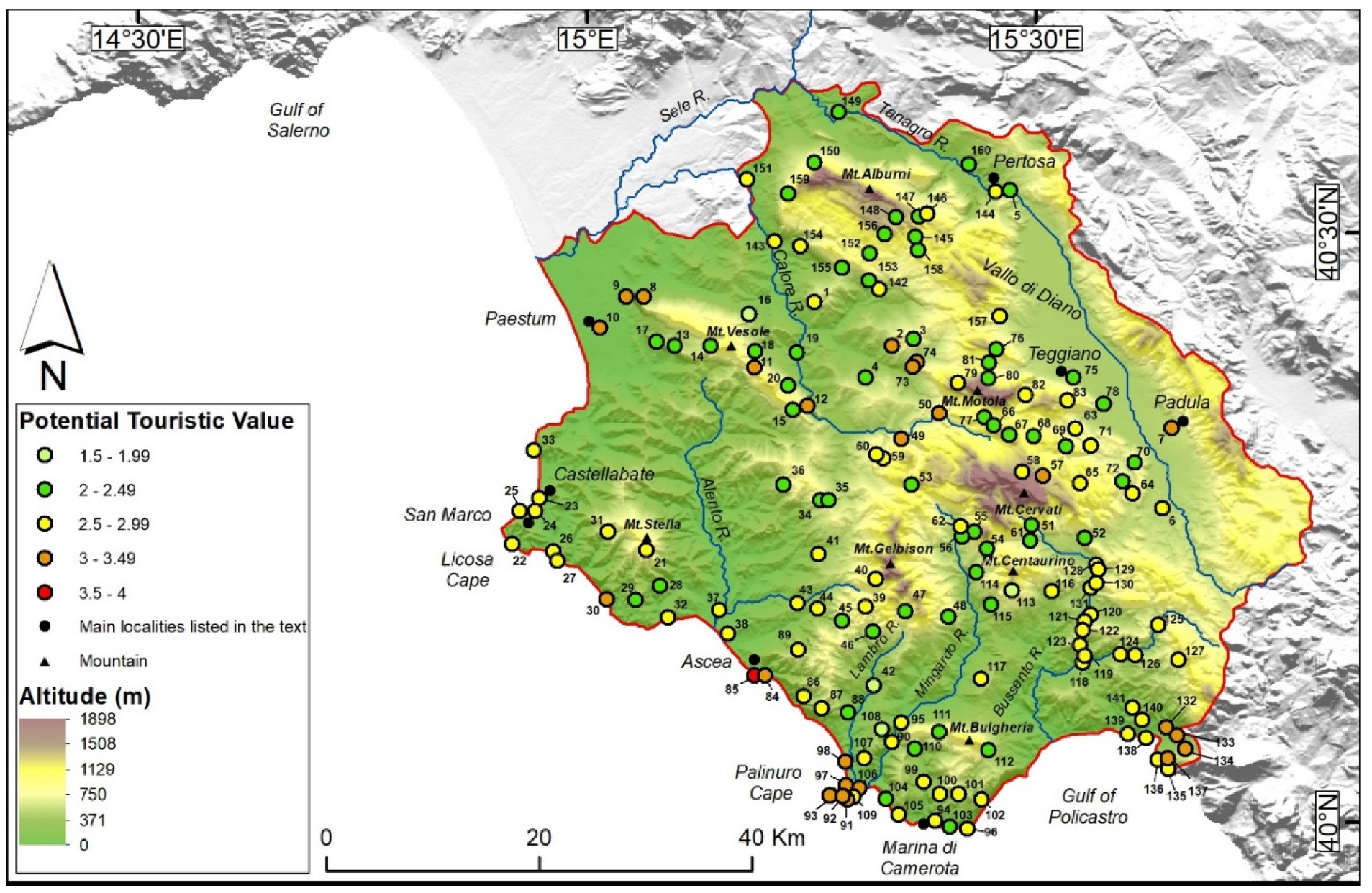
4.1. Geosites and Geomorphosites Evaluation
- -
- Thirty-one sites (19% of the total) gained an EV larger than three;
- -
- Twenty-one sites (13% of the total) gained a TV larger than three;
- -
- Sites with the highest scores of both indexes are mainly clustered in three areas: the coastal area between San Marco and Marina di Camerota; the inner sector between Mt. Vesole, to the west, and the Vallo di Diano basin to the east; the south-eastern corner of the Geopark between Mt. Centaurino and the Gulf of Policastro;
- -
- There are portions of the CVDA Geopark that already attract many tourists in the summer period, such as the Castellabate and the Palinuro cape area, which also exhibits high values of both the EV and TV indexes, thus suggesting their potential also as a geotourist attractor;
- -
- -
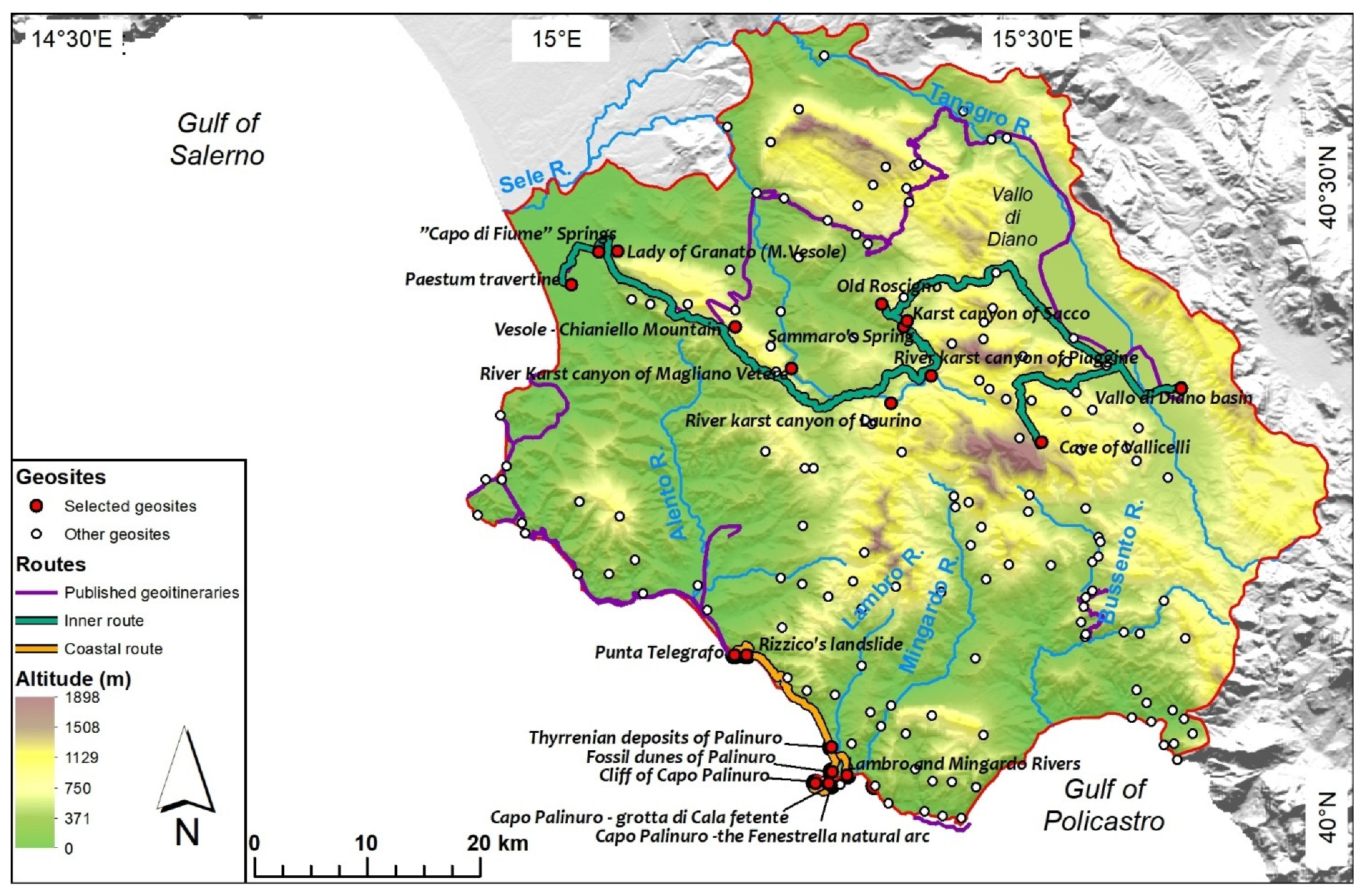
4.2. The Geoitineraries
4.2.1. The Inner Geoitinerary
4.2.2. The Coastal Geoitinerary
5. Discussion and Conclusions
Supplementary Materials
Author Contributions
Funding
Conflicts of Interest
References
- Dowling, R.; Newsome, D. The scope and nature of geotourism. In Geotourism; Dowling, R., Newsome, D., Eds.; Routledge: Oxford, UK, 2006; pp. 31–53. [Google Scholar]
- Newsome, D.; Dowling, R.K. Setting an agenda for geotourism. In Geotourism: The tourism of Geology and Landscape; Goodfellow Publishers: Oxford, UK, 2010; pp. 1–12. [Google Scholar]
- Newsome, D.; Dowling, R. Geoheritage and Geotourism; Elsevier BV: Amsterdam, The Netherlands, 2018; pp. 305–321. [Google Scholar]
- Hose, T.A. Selling the Story of Britain’s Stone. Environ. Interpret. 1995, 10, 16–17. [Google Scholar]
- Hose, T.A. 3G’s for Modern Geotourism. Geoheritage 2012, 4, 7–24. [Google Scholar] [CrossRef]
- Ólafsdóttir, R.; Tverijonaite, E. Geotourism: A Systematic Literature Review. Geosciences 2018, 8, 234. [Google Scholar] [CrossRef] [Green Version]
- Piacentini, T.; Castaldini, D.; Coratza, P.; Farabollini, P.; Miccadei, E. Geotourism: Some examples in northern-central Italy. GeoJ. Tour. Geosites 2011, 8, 240–262. [Google Scholar]
- Dowling, R.; Newsome, D. Chapter 1: Geotourism: Definition, characteristics and international perspectives. In Handbook of Geotourism; Edward Elgar Publishing: Cheltenham, UK; Camberley, UK, 2018; pp. 1–22. [Google Scholar]
- The Arouca Declaration. Available online: http://www.unesco.org/new/fileadmin/MULTIMEDIA/HQ/SC/pdf/Geopark_Arouca_Declaration_EGN_2012.pdf (accessed on 14 September 2021).
- Reynard, E. Protecting Stones: Conservation of erratic blocks in Switzerland. In Dimension Stone 2004, New Perspectives for a Traditional Building Material; Prykril, R., Ed.; A.A. Balkema Publishers: Leiden, The Netherlands, 2004; pp. 3–7. [Google Scholar]
- Panizza, M. Geomorphosites: Concepts, methods and examples of geomorphological survey. Chin. Sci. Bull. 2001, 46, 4–5. [Google Scholar] [CrossRef]
- Zouros, N. The European Geoparks Network—Geological heritage protection and local development. Episodes 2004, 27, 165–171. [Google Scholar] [CrossRef] [Green Version]
- Eder, F.W. Geoparks—GEOLOGICAL attractions: A tool for public education, recreation and sustainable economic development. Episodes 2004, 27, 162–164. [Google Scholar] [CrossRef] [Green Version]
- UNESCO Global Geopark Definition. Available online: http://www.globalgeopark.org/aboutGGN/6398.htm (accessed on 14 September 2021).
- Map of UNESCO Global Geopark. Available online: http://www.globalgeopark.org/aboutGGN/MemberList/index.htm (accessed on 14 September 2021).
- Santangelo, N.; Santo, A.; Guida, D.; Lanzara, R.; Siervo, V. The geosites of the Cilento-Vallo di Diano national park (Campania region, southern Italy). Il Quat. 2005, 18, 101–112. [Google Scholar]
- Cilento, Vallo di Diano and Alburni Geopark Geosites Database. Available online: http://www.cilentoediano.it/it/geositi-gli-ambiti-paesaggio (accessed on 15 September 2021).
- Valente, E.; Santo, A.; Guida, D.; Santangelo, N. Geotourism in the Cilento, Vallo di Diano and Alburni UNESCO Global Geopark (Southern Italy): The Middle Bussento Karst System. Resources 2020, 9, 52. [Google Scholar] [CrossRef]
- Santangelo, N.; Romano, P.; De Santo, A.V. Geo-itineraries in the Cilento Vallo di Diano Geopark: A Tool for Tourism Development in Southern Italy. Geoheritage 2014, 7, 319–335. [Google Scholar] [CrossRef]
- Santangelo, N.; Amato, V.; Ascione, A.; Ermolli, E.R.; Valente, E. GEOTOURISM as a Tool for Learning: A Geoitinerary in the Cilento, Vallo di Diano and Alburni Geopark (Southern Italy). Resources 2020, 9, 67. [Google Scholar] [CrossRef]
- Aloia, A.; De Vita, A.; Guida, D.; Toni, A.; Valente, A. National Park of Cilento and Vallo di Diano: Geodiversity, geotourism, geoarchaeology and historical tradition. In Proceedings of the 9th European Geopark Conference—European Geopark Network, Mytilene Lesvos, Greece, 1–5 October 2010; p. 41. [Google Scholar]
- Aloia, A.; De Vita, A.; Guida, D.; Toni, A.; Valente, A. La geosiversità del Parco Nazionale del Cilento e Vallo di Diano: Verso il Geoparco. In Proceedings of the Atti del Convegno Nazionale “Il Patrimonio Geologico: Una risorsa da proteggere e valorizzare”, Sasso di Castalda, Italy, 29–30 April 2010; pp. 188–202. [Google Scholar]
- Aloia, A.; Guida, D.; Valente, A. Geodiversity in the Geopark of Cilento and Vallo di Diano as heritage and resource development. Rend. Online Soc. Geol. Ital. 2012, 21, 688–690. [Google Scholar]
- Aloia, A.; Guida, D. The Geosites: Geopark’s Gaia Synphony in the Cilento, Vallo Diano and Alburni Geopark, Geopark Book n. 1; Cilento, Vallo di Diano and Alburni Geopark: Vallo della Lucania, Italy, 2014. [Google Scholar]
- Calcaterra, D.; D’Argenio, B.; Ferranti, L.; Pappone, G.; Petrosino, P. Guide Geologiche Regionali, Campania e Molise; Società Geologica Italiana: Rome, Italy, 2016; p. 276. [Google Scholar]
- Mazzoli, S.; Helman, M. Neogene patterns of relative plate motion for Africa-Europe: Some implications for recent central Mediterranean tectonics. Geol. Rundsch. 1994, 83, 464–468. [Google Scholar] [CrossRef]
- Turco, E.; Macchiavelli, C.; Mazzoli, S.; Schettino, A.; Pierantoni, P. Kinematic evolution of Alpine Corsica in the framework of Mediterranean mountain belts. Tectonophysics 2012, 579, 193–206. [Google Scholar] [CrossRef]
- Ciarcia, S.; Mazzoli, S.; Vitale, S.; Zattin, M. On the tectonic evolution of the Ligurian accretionary complex in southern Italy. Bulletin 2011, 124, 463–483. [Google Scholar] [CrossRef]
- Ascione, A.; Ciarcia, S.; DI Donato, V.; Mazzoli, S.; Vitale, S. The Pliocene-Quaternary wedge-top basins of southern Italy: An expression of propagating lateral slab tear beneath the Apennines. Basin Res. 2011, 24, 456–474. [Google Scholar] [CrossRef]
- Mazzoli, S.; Szaniawski, R.; Mittiga, F.; Ascione, A.; Capalbo, A. Tectonic evolution of Pliocene–Pleistocene wedge-top basins of the southern Apennines: New constraints from magnetic fabric analysis. Can. J. Earth Sci. 2012, 49, 492–509. [Google Scholar] [CrossRef]
- Gray, J.M. Geodiversity: Developing the paradigma. Proc. Geol. Assoc. 2008, 119, 287–298. [Google Scholar] [CrossRef]
- Ruban, D. Quantification of geodiversity and its loss. Proc. Geol. Assoc. 2010, 121, 326–333. [Google Scholar] [CrossRef]
- Santangelo, A.; Santo, A. Endokarst processes in the Alburni massif (Campania, Southern Italy): Evolution of ponors and hydrogeological implications. Z. Geomorphol. 1997, 41, 229–246. [Google Scholar] [CrossRef]
- Vitale, S.; Ciarcia, S. Tectono-stratigraphic and kinematic evolution of the southern Apennines/Calabria–Peloritani Terrane system (Italy). Tectonophysics 2013, 583, 164–182. [Google Scholar] [CrossRef]
- Corrado, S.; Aldega, L.; Perri, F.; Critelli, S.; Muto, F.; Schito, A.; Tripodi, V. Detecting syn-orogenic extension and sediment provenance of the Cilento wedge top basin (southern Apennines, Italy): Mineralogy and geochemistry of fine-grained sediments and petrography of dispersed organic matter. Tectonophysics 2019, 750, 404–418. [Google Scholar] [CrossRef]
- Geological Map of Italy at Scale 1:50,000, Sheet 502—Agropoli. Available online: http://www.isprambiente.gov.it/Media/carg/502_AGROPOLI/Foglio.html (accessed on 30 September 2021).
- Geological Map of Italy at Scale 1:50,000, Sheet 503—Vallo. Available online: http://www.isprambiente.gov.it/Media/carg/503_VALLO/Foglio.html (accessed on 30 September 2021).
- Geological Map of Italy at Scale 1:50,000, Sheet 519—Capo Palinuro. Available online: http://www.isprambiente.gov.it/Media/carg/519_CAPO_PALINURO/Foglio.html (accessed on 30 September 2021).
- Vitale, S.; Ciarcia, S.; Mazzoli, S.; Zaghloul, M. Tectonic evolution of the ‘Liguride’ accretionary wedge in the Cilento area, southern Italy: A record of early Apennine geodynamics. J. Geodyn. 2011, 51, 25–36. [Google Scholar] [CrossRef] [Green Version]
- Vitale, S.; Ciarcia, S.; Fedele, L.; Tramparulo, F.D. The Ligurian oceanic successions in southern Italy: The key to decrypting the first orogenic stages of the southern Apennines-Calabria chain system. Tectonophysics 2019, 750, 243–261. [Google Scholar] [CrossRef]
- Ascione, A.; Romano, P. Vertical movements on the eastern margin of the Tyrrhenian extensional basin. New data from Mt. Bulgheria (Southern Apennines, Italy). Tectonophysics 1999, 315, 337–356. [Google Scholar] [CrossRef]
- Iannace, A.; Romano, P.; Santangelo, N.; Santo, A.; Tuccimei, P. The OIS 5c along Licosa cape promontory (Campania region, southern Italy): Morphostratigraphy and U/Th dating. Z. Geomorphol. 2001, 45, 307–319. [Google Scholar] [CrossRef]
- Cinque, A.; Romano, P.; Rosskopf, C.; Santangelo, N.; Santo, A. Morfologie costiere e depositi quaternari tra Agropoli e Ogliastro Marina (Cilento—Italia Meridionale). Il Quat. 1994, 7, 3–16. [Google Scholar]
- Cinque, A.; Rosskopf, C.; Barra, D.; Campajola, L.; Paolillo, G.; Romano, P. Nuovi dati stratigrafici e cronologici sull’evoluzione recente della piana del fiume Alento (Cilento, Campania). Il Quat. 1995, 8, 323–338. [Google Scholar]
- Karner, D.; Juvigne, E.; Brancaccio, L.; Cinque, A.; Ermolli, E.R.; Santangelo, N.; Bernasconi, S.; Lirer, L. A potential early middle Pleistocene tephrostratotype for the Mediterranean basin: The Vallo Di Diano, Campania, Italy. Glob. Planet. Chang. 1999, 21, 1–15. [Google Scholar] [CrossRef]
- Santangelo, N.; Amato, M.; Ascione, A.; Cafaro, S.; Calcatera, D.; Romano, P. Geological field trip n. 4: From Vallo di Diano to Angelo caves. In Field Trip Guide Book 12° European Geopark Conference; Aloia, A., Calcaterra, D., Guida, D., Valloni, R., Eds.; National Park of Cilento Vallo di Diano and Alburni: Vallo della Lucania, Italy, 2013; pp. 42–52. [Google Scholar]
- Santangelo, N.; Bravi, S.; Santo, A. Itinerario 12 Piana del Sele, Monti Alburni e Vallo di Diano. In Guide Geologiche Regionali—Campania e Molise; Calcaterra, D., D’Argenio, B., Ferranti, L., Pappone, G., Petrosino, P., Eds.; Società Geologica Italiana: Rome, Italy, 2016; pp. 227–242. ISBN 9788894022728. [Google Scholar]
- Vitale, S.; Amore, O.; Ciarcia, S.; Lo Schiavo, L.; Santangelo, N.; Tramparulo, F. Itinerario 11-Cilento settentrionale. In Guide Geologiche Regionali—Campania e Molise; Calcaterra, D., D’Argenio, B., Ferranti, L., Pappone, G., Petrosino, P., Eds.; Società Geologica Italiana: Rome, Italy, 2016; pp. 69–80. ISBN 9788894022728. [Google Scholar]
- Brilha, J.B. Inventory and Quantitative Assessment of Geosites and Geodiversity Sites: A Review. Geoheritage 2016, 8, 119–134. [Google Scholar] [CrossRef] [Green Version]
- Dyson, R. Strategic development and SWOT analysis at the University of Warwick. Eur. J. Oper. Res. 2004, 152, 631–640. [Google Scholar] [CrossRef]
- Carrión-Mero, P.; Loor-Oporto, O.; Andrade-Ríos, H.; Herrera-Franco, G.; Morante-Carballo, F.; Jaya-Montalvo, M.; Aguilar-Aguilar, M.; Torres-Peña, K.; Berrezueta, E. Quantitative and Qualitative Assessment of the “El Sexmo” Tourist Gold Mine (Zaruma, Ecuador) as A Geosite and Mining Site. Resources 2020, 9, 28. [Google Scholar] [CrossRef] [Green Version]
- Kubalíková, L.; Kirchner, K. Geosite and Geomorphosite Assessment as a Tool for Geoconservation and Geotourism Purposes: A Case Study from Vizovická vrchovina Highland (Eastern Part of the Czech Republic). Geoheritage 2016, 8, 5–14. [Google Scholar] [CrossRef]
- NASA Shuttle Radar Topography Mission. Available online: https://srtm.csi.cgiar.org/srtmdata/ (accessed on 20 September 2021).
- Amato, V.; Aucelli, P.P.C.; D’Argenio, B.; Da Prato, S.; Ferraro, L.; Pappone, G.; Petrosino, P.; Rosskopf, C.M.; Ermolli, E.R. Holocene environmental evolution of the costal sector in front of the Poseidonia-Paestum archaeological area (Sele plain, southern Italy). Rend. Lince 2012, 23, 45–59. [Google Scholar] [CrossRef]
- Illustrative Notes of the Geological Map of Italy at Scale 1:50,000, Sheet 486—Foce del Sele. Available online: https://www.isprambiente.gov.it/Media/carg/note_illustrative/486_FocedelSele.pdf (accessed on 26 October 2021).
- Migoń, P.; Pijet-Migoń, E. Viewpoint geosites—Values, conservation and management issues. Proc. Geol. Assoc. 2017, 128, 511–522. [Google Scholar] [CrossRef]
- Valiante, M.; Guida, D.; Della Seta, M.; Bozzano, F. A spatiotemporal object-oriented data model for landslides (LOOM). Landslides 2021, 18, 1231–1244. [Google Scholar] [CrossRef]
- De Riso, R.; Santo, A. Geologia, evoluzione geomorfologica e frane del bacino del T. Pietra (Campania). Quad. Geol. Appl. 1997, 4, 19–33. [Google Scholar]
- Technical Map of the Campania Region at Scale 1:5000. Available online: https://sit2.regione.campania.it/content/carta-tecnica-regionale-2004-2005 (accessed on 30 October 2021).
- Calcaterra, D.; Guida, D.; Budetta, P.; De Vita, P.; Di Martire, D.; Aloia, A. Moving geosites: How landslides can become focal points in Geoparks. Latest Trends Eng. Mech. Struct. Eng. Geol. 2014, 2, 162–171. [Google Scholar]
- Piperno, M. La Preistoria alle Falde del M. Cervati; Parco Nazionale del Cilento e Vallo di Diano, Ed.; Cilento, Vallo di Diano and Alburni Geopark: Vallo della Lucania, Italy, 2001; p. 12. [Google Scholar]
- Villani, F.; Pierdominici, S. Late Quaternary tectonics of the Vallo di Diano basin (southern Apennines, Italy). Quat. Sci. Rev. 2010, 29, 3167–3183. [Google Scholar] [CrossRef]
- Santangelo, N. Evoluzione Stratigrafica, Geomorfologica Eneotettonica di Alcuni Bacini Lacustri del Confine Campano Lucano (Italia Meridionale). Ph.D. Thesis, University of Naples ‘‘Federico II’’, Naples, Italy, 1991. Unpublished. [Google Scholar]
- Ascione, A.; Cinque, A.; Santangelo, N.; Tozzi, M. Il bacino del Vallo di Diano e la tettonica trascorrente plio-quaternaria: Nuovi vincoli cronologici e cinematici. Studi Geol. Camerti 1992, 1, 201–208. [Google Scholar]
- Budetta, P.; Santangelo, N.; Santo, A. Interazioni tra processi alluvionali e insediamenti abitativi in epoca storica: Il caso della Certosa di Padula. I Convegno GeoBen 2000, 6, 41–48. [Google Scholar]
- Santangelo, N.; Daunisiestadella, J.; Di Crescenzo, G.; DI Donato, V.; Faillace, P.I.; Martín-Fernández, J.A.; Romano, P.; De Santo, A.V.; Scorpio, V. Topographic predictors of susceptibility to alluvial fan flooding, Southern Apennines. Earth Surf. Process. Landf. 2012, 37, 803–817. [Google Scholar] [CrossRef]
- Marciano, R.; Munno, R.; Petrosino, P.; Santangelo, N.; Santo, A.; Villa, I. Late quaternary tephra layers along the Cilento coastline (southern Italy). J. Volcanol. Geotherm. Res. 2008, 177, 227–243. [Google Scholar] [CrossRef]
- De Vita, P.; Cusano, D.; La Barbera, G. Complex Rainfall-Driven Kinematics of the Slow-Moving Pisciotta Rock-Slide (Cilento, Southern Italy). In Advancing Culture of Living with Landslides; Mikos, M., Casagli, N., Yin, Y., Sassa, K., Eds.; Springer: Cham, Switzerland, 2017; Volume 4, pp. 547–556. [Google Scholar]
- De Vita, P.; Carratù, M.; La Barbera, G.; Santoro, S. Kinematics and geological constraints of the slow-moving Pisciotta rock slide (southern Italy). Geomorphology 2013, 201, 415–429. [Google Scholar] [CrossRef]
- Calaforra, J.M.; Fernandez-Cortes, A. Geotourism in Spain: Resources, environmental management. In Geotourism. Sustainabilty, Impact and Management; Dowling, R., Newsome, D., Eds.; Elsevier: Oxford, UK, 2006; pp. 199–220. [Google Scholar]
- Doorne, S. Caves, Cultures and Crowds: Carrying Capacity Meets Consumer Sovereignty. J. Sustain. Tour. 2000, 8, 116–130. [Google Scholar] [CrossRef]
- Amodio, T. La dimensione territoriale dell’ospitalità turistica in provincia di Salerno. Boll. Dell’associazione Ital. Cartogr. 2016, 157, 105–116. [Google Scholar] [CrossRef]
- Italan Ministry of the Environment, Technical Analysis 2017. Available online: https://www.minambiente.it/sites/default/files/archivio/allegati/biodiversita/Rapporto_Natura_Cultura.pdf (accessed on 31 May 2020).
- Di Martino, P.; Petrillo, C.S. An International Project to Develop Networking for Promoting a Specific Destination: Emigration as a Tool to Enhance Tourism in Cilento Area. In Tourism Local Systems and Networking; Elsevier BV: Amsterdam, The Netherlands, 2006; pp. 219–233. [Google Scholar]


| Inner Geoitinerary | |||
|---|---|---|---|
| Site Label | Site Name | Field of Interest | Description |
| 10 | Paestum travertine | Quaternary geology | Travertines fed by the Capo di Fiume spring and accumulated near the archaeological area of Paestum |
| 9 | Capo di Fiume spring | Hydrogeology | Spring feeding travertine deposition near the archaeological area of Paestum |
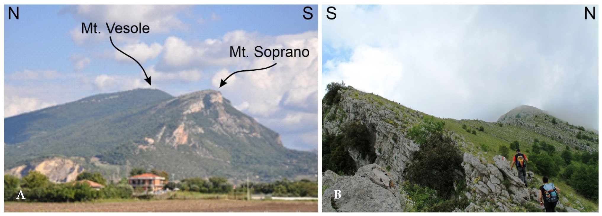
| 8 | Lady of Granato (Mt. Vesole) | Paleontology | Limestone with fossil rich layers |
| 11 | Vesole-Chianello Mts. | Geomorphology | Cuesta-like ridge |
| 12 | Karst canyon of Magliano Vetere | Geomorphology | Fluvio-karst landform |
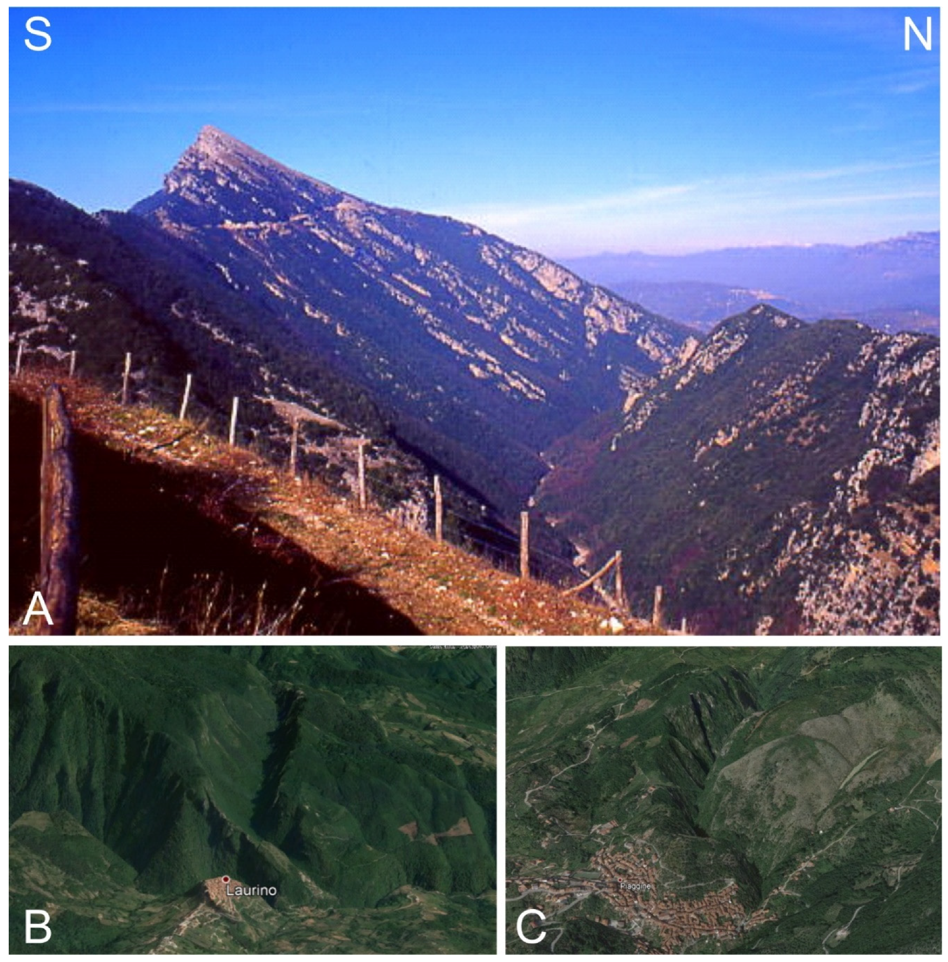
| 49 | Karst canyon of Laurino | Geomorphology | Fluvio-karst landform |
| 50 | Karst canyon of Piaggine | Geomorphology | Fluvio-karst landform |
| 73 | Sammaro spring | Hydrogeology | Karst spring |
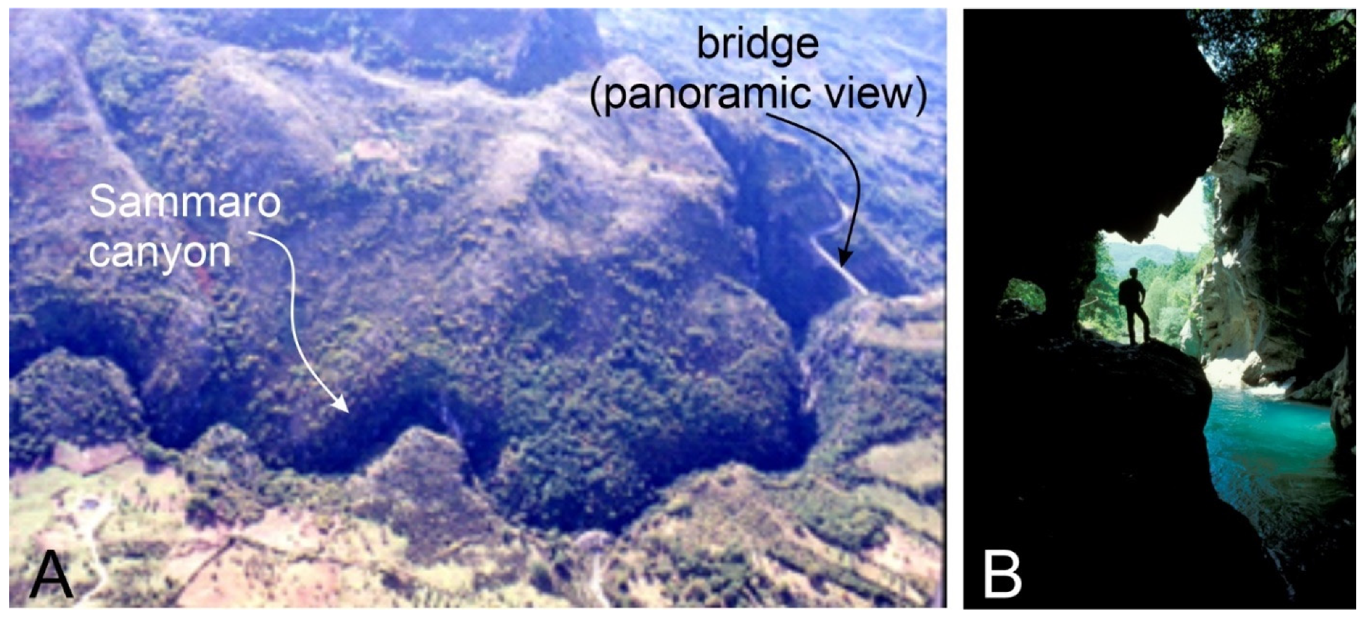
| 74 | Karst canyon of Sacco | Geomorphology | Fluvio-karst landform |
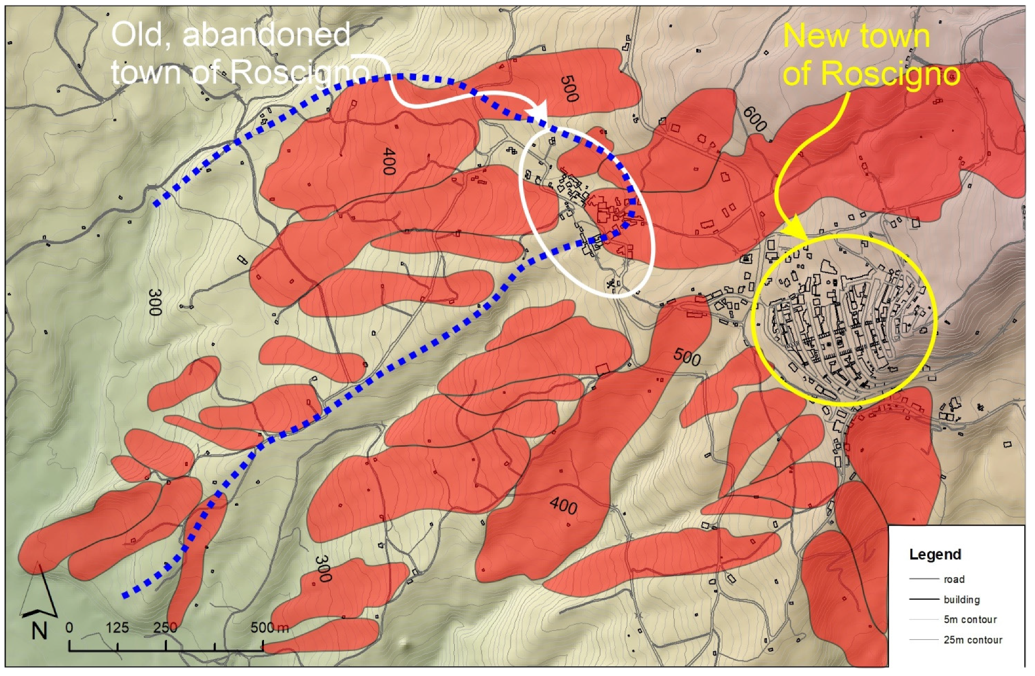
| 2 | Old Roscigno | Geomorphology Applied Geology | Active landslide that caused the abandonment of the old town Roscigno |
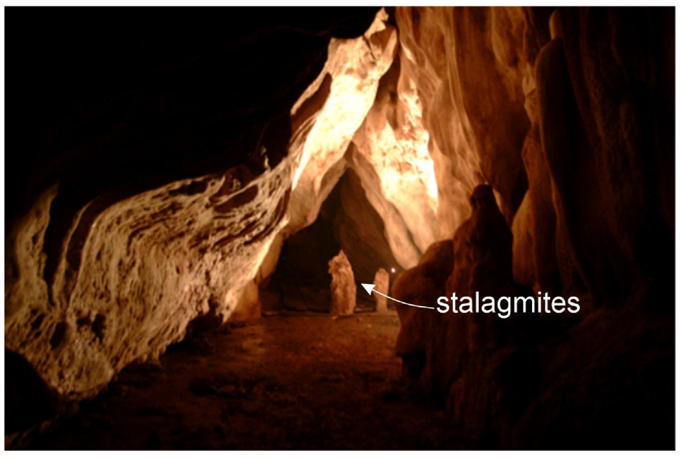
| 57 | Cave of Vallicelli karst area | Geomorphology Geoarchaeology | Karst caves with human frequentation since Prehistoric time |
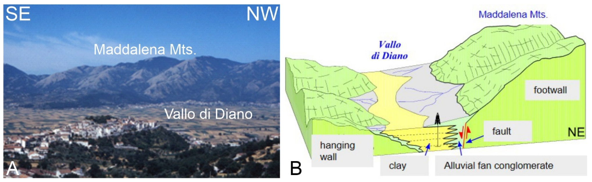
| 7 | Vallo di Diano basin | Geomorphology Quaternary Geology | Largest intramontane basin of the Southern Apennine |
| Coastal Geoitinerary | |||
| Site Label | Site Name | Field of Interest | Description |
| 85 | Punta Telegrafo | Structural geology Quaternary geology Geomorphology | Deformed bedrock units and marine terrace |
| 84 | Rizzico landslide | Applied Geology | Landslide potentially affecting the railway |
| 98 | Tyrrhenian deposits of Palinuro | Quaternary geology | Upper Pleistocene marine deposits |
| 97 | Fossil dunes of Palinuro | Quaternary geology | Upper Pleistocene aeolian deposits |
| 93 | Cliff of Capo Palinuro | Geomorphology | Limestone rocky coast |
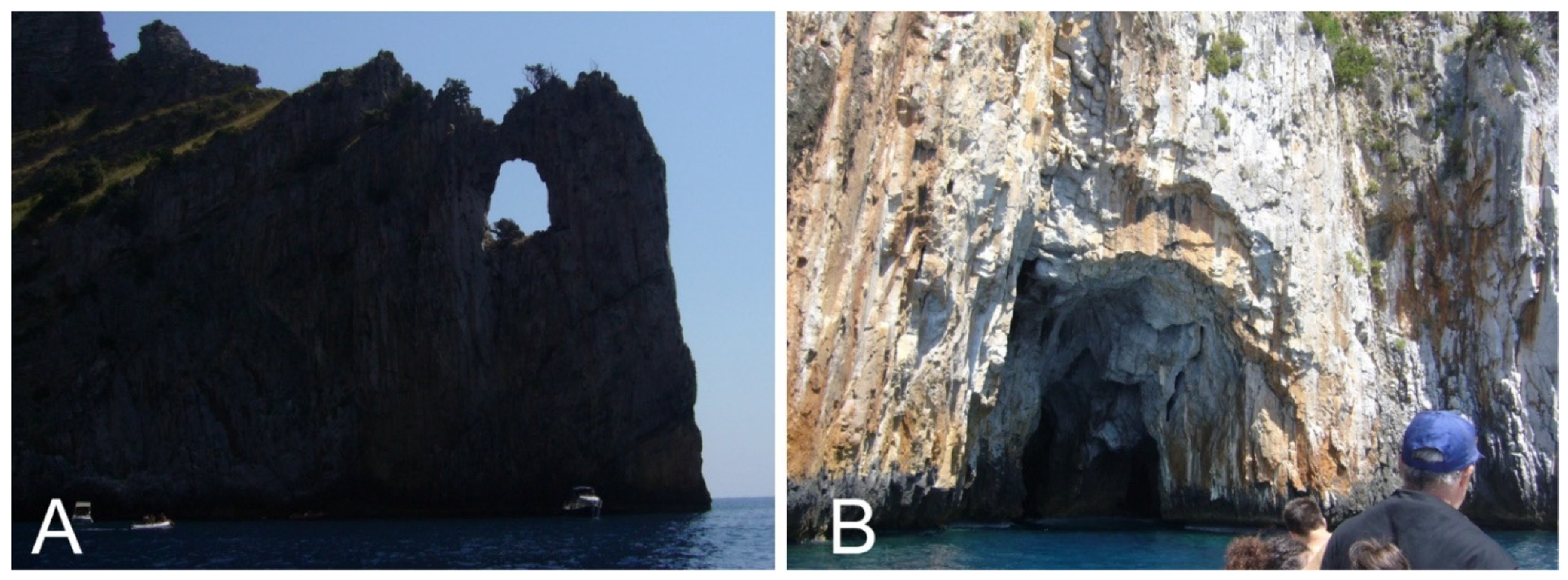
| 91 | Fenestrella natural arc | Geomorphology | Karst landform on the rocky coast of Palinuro cape |
| 92 | Cala Fetente cave | Geomorphology | Cave along the rocky coast of Palinuro cape |
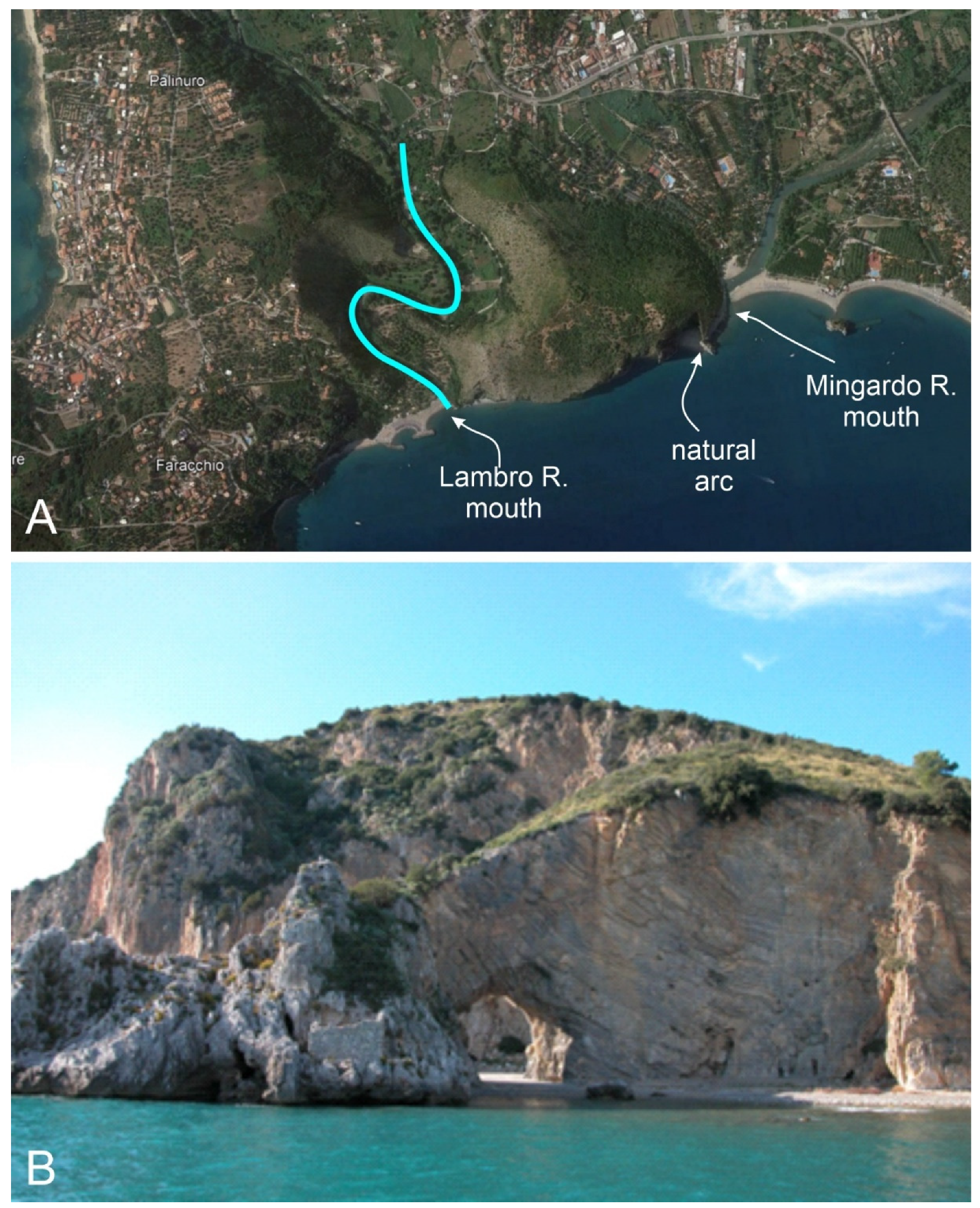
| 106 | Lambro and Mingardo rivers mouths | Geomorphology | Palinuro natural arc and entrenched meanders of the Lambro River |
| Strengths | Weaknesses |
|---|---|
|
|
| Opportunities | Threats |
|
|
Publisher’s Note: MDPI stays neutral with regard to jurisdictional claims in published maps and institutional affiliations. |
© 2021 by the authors. Licensee MDPI, Basel, Switzerland. This article is an open access article distributed under the terms and conditions of the Creative Commons Attribution (CC BY) license (https://creativecommons.org/licenses/by/4.0/).
Share and Cite
Valente, E.; Casaburi, A.; Finizio, M.; Papaleo, L.; Sorrentino, A.; Santangelo, N. Defining the Geotourism Potential of the CILENTO, Vallo di Diano and Alburni UNESCO Global Geopark (Southern Italy). Geosciences 2021, 11, 466. https://doi.org/10.3390/geosciences11110466
Valente E, Casaburi A, Finizio M, Papaleo L, Sorrentino A, Santangelo N. Defining the Geotourism Potential of the CILENTO, Vallo di Diano and Alburni UNESCO Global Geopark (Southern Italy). Geosciences. 2021; 11(11):466. https://doi.org/10.3390/geosciences11110466
Chicago/Turabian StyleValente, Ettore, Annarita Casaburi, Michele Finizio, Lorenzo Papaleo, Alessia Sorrentino, and Nicoletta Santangelo. 2021. "Defining the Geotourism Potential of the CILENTO, Vallo di Diano and Alburni UNESCO Global Geopark (Southern Italy)" Geosciences 11, no. 11: 466. https://doi.org/10.3390/geosciences11110466
APA StyleValente, E., Casaburi, A., Finizio, M., Papaleo, L., Sorrentino, A., & Santangelo, N. (2021). Defining the Geotourism Potential of the CILENTO, Vallo di Diano and Alburni UNESCO Global Geopark (Southern Italy). Geosciences, 11(11), 466. https://doi.org/10.3390/geosciences11110466