Investigation of Spatial and Temporal Changes in the Land Surface Albedo for the Entire Chinese Territory
Abstract
1. Introduction
1.1. Urbanization
1.2. Global Climate Change and Urban Heat Island
1.3. Urban Albedo and Satellite Technology
1.4. Aims of This Study
2. Methodology and Materials
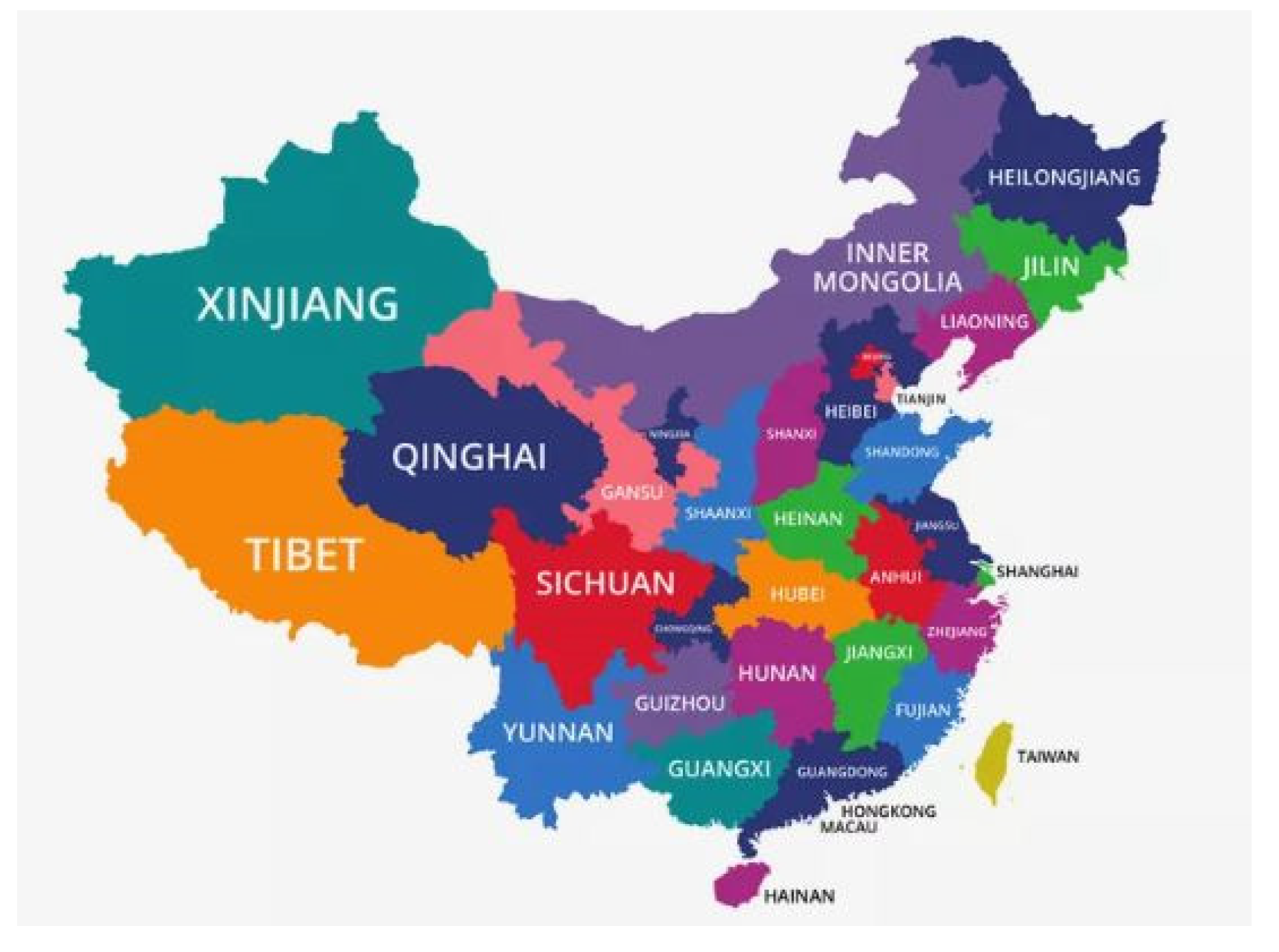
2.1. Study Area
2.2. Database
2.3. Method of Drawing Contour Maps
- 1st step: To obtain the database of surface albedo from the MODIS sensors, within the Chinese territory;
- 2nd step: To grid the surface albedo data format (.csv) into another data format (.grd), using Surfer 14;
- 3rd step: To get the polygon file of a country using “maptools” in R programming [36];
- 4th step: To add the new surface albedo data format (.grd) to the polygon file of a country (e.g., CHN.shp, CHN.bln, etc.).
2.4. Method of Classification
2.5. Normalized Difference Vegetation Index
3. Results
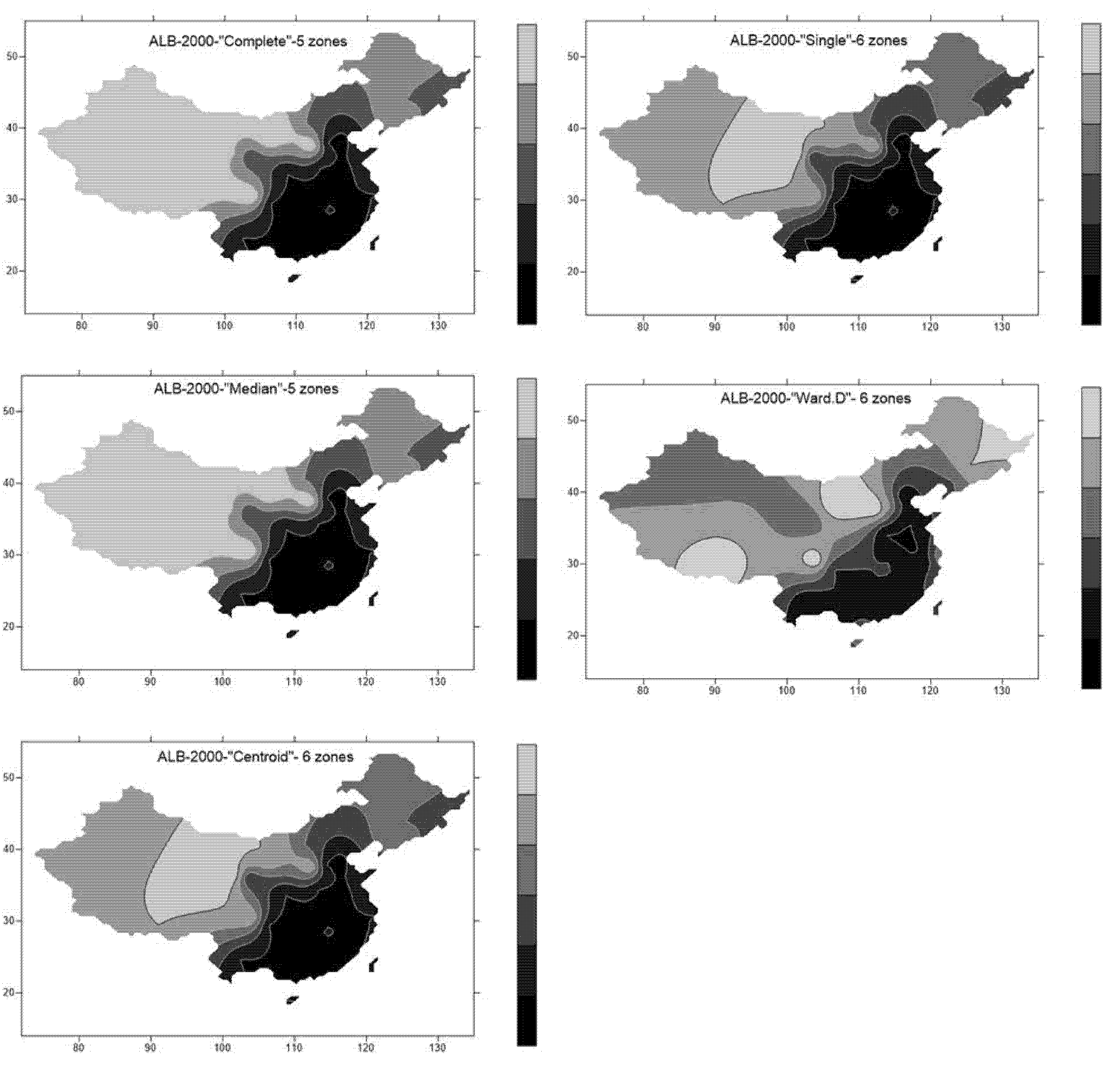
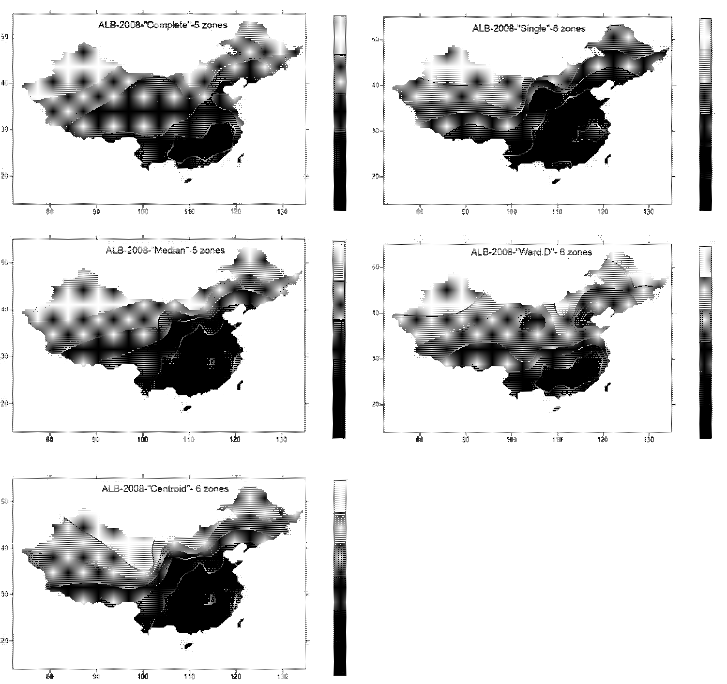
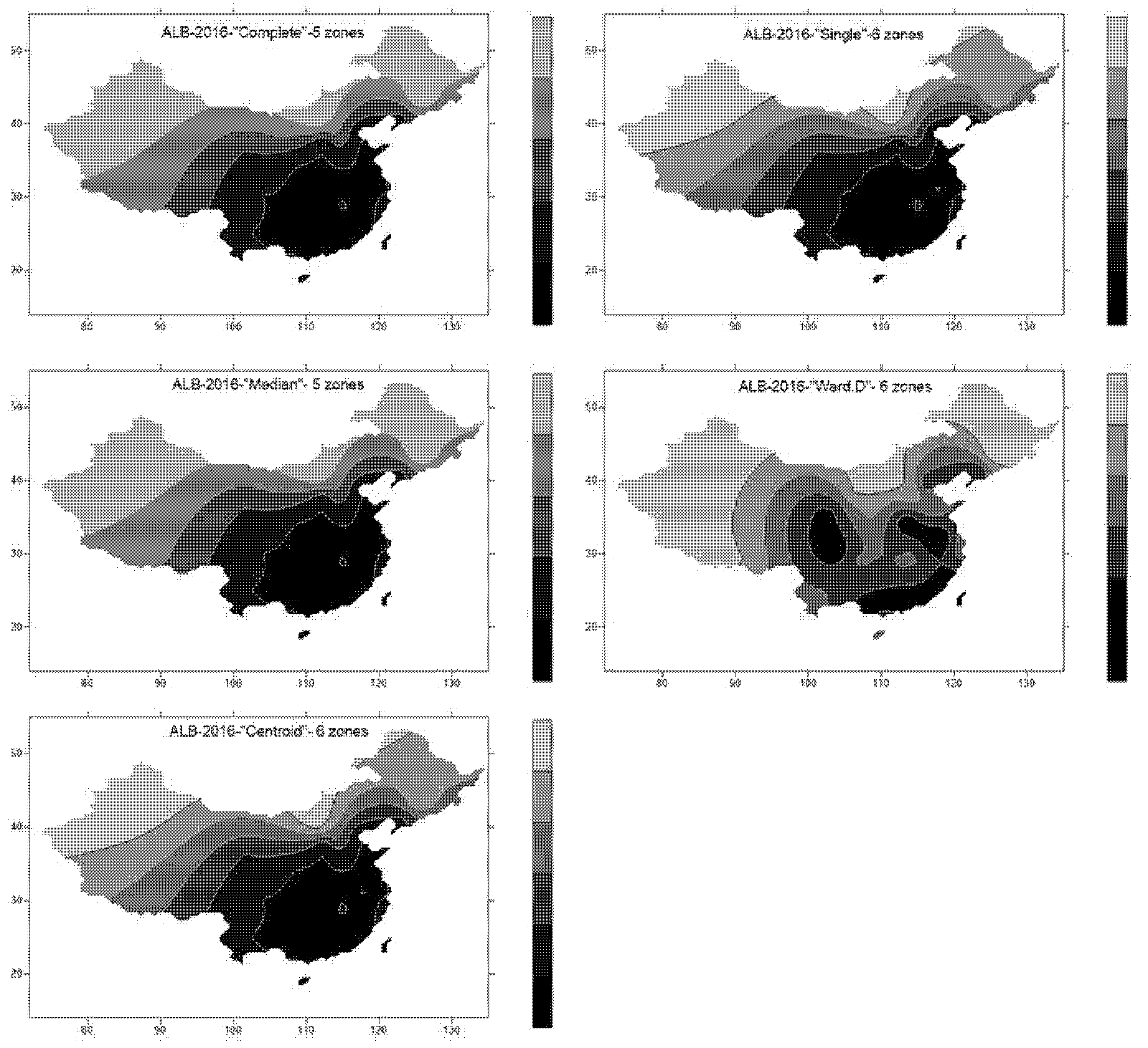
3.1. Contour Maps of Surface Albedo
3.2. Classification of Surface Albedo
3.3. Surface Albedo of Provincial Capitals
3.4. Surface Albedo Variations
3.5. Change in NDVI
4. Discussion
5. Conclusions and Future Work
Funding
Conflicts of Interest
References
- Urbanization in 2013. Demographic Partitions. Available online: http://demographicpartitions.org/urbanization-2013 (accessed on 5 September 2019).
- World Urbanization Prospects: The 2014 Revision. Available online: https://population.un.org/wup/Publications/Files/WUP2014-Highlights.pdf (accessed on 10 July 2020).
- Urban Life: Open-Air Computers. The Economist. 27 October 2012. Retrieved 20 March 2013. Available online: https://www.economist.com/special-report/2012/10/27/open-air-computers (accessed on 9 September 2019).
- Urbanization. UNFPA—United Nations Population Fund. Available online: https://www.unfpa.org/icpd/urbanization (accessed on 9 September 2019).
- Cohen, B. Urbanization, City Growth, and the New United Nations Development Agenda. Cornerstone Off. J. World Coal Ind. 2015, 3, 4–7. [Google Scholar]
- China Urbanization. Available online: http://english.cntv.cn/2016/01/30/VIDEf3nCcpAiITmx5J17brHD160130.shtml (accessed on 23 July 2019).
- Loeb, N.G.; Lyman, J.M.; Johnson, G.C.; Allan, R.P.; Doelling, D.R.; Wong, T.; Soden, B.J.; Stephens, G.L. Observed changes in top-of-the-atmosphere radiation and upper-ocean heating consistent within uncertainty. Nat. Geosci. 2012, 5, 110–113. [Google Scholar] [CrossRef]
- Stephens, G.L.; Li, J.; Wild, M.; Clayson, C.A.; Loeb, N.; Kato, S.; L’Ecuyer, T.; Stackhouse, P.W., Jr.; Lebsock, M.; Andrews, T. An update on Earth’s energy balance in light of the latest global observations. Nat. Geosci. 2012, 5, 691–696. [Google Scholar] [CrossRef]
- Solecki, W.D.; Rosenzweig, C.; Parshall, L.; Pope, G.; Clark, M.; Cox, J.; Wiencke, M. Mitigation of the heat island effect in urban New Jersey. Glob. Environ. Chang. Part B Environ. Hazards 2015, 6, 39–49. [Google Scholar] [CrossRef]
- United States Environmental Protection Agency. Reducing Urban Heat Islands: Compendium of Strategies (Report). 2008; pp. 7–12. Available online: https://www.epa.gov/heatislands/heat-island-compendium (accessed on 1 September 2019).
- Arthur, R.; Romm, J.; Akbari, H.; Lloyd, A. Painting the Town White—And Green. MIT Technology Review. Available online: https://www.researchgate.net/publication/265497350_Painting_the_Town_White_--and_Green (accessed on 1 September 2019).
- Li, Y.; Zhao, X. An empirical study of the impact of human activity on long-term temperature change in China: A perspective from energy consumption. J. Geophys. Res. 2002, 117, D17. [Google Scholar] [CrossRef]
- Howard, L.; IAUC Edition. The Climate of London. 2007. Available online: https://www.urban-climate.org/documents/LukeHoward_Climate-of-London-V1.pdf (accessed on 9 September 2020).
- Bornstein, R.D. Observations of the Urban Heat Island Effect in New York City. J. Appl. Meteorol. 1968, 7, 575–582. [Google Scholar] [CrossRef]
- Saitoh, T.S.; Shimada, T.; Hoshi, H. Modeling and simulation of the Tokyo urban heat island. Atmos. Environ. 1996, 30, 3431–3442. [Google Scholar] [CrossRef]
- Kato, S.; Yamaguchi, Y. Analysis of urban heat-island effect using ASTER and ETM+ Data: Separation of anthropogenic heat discharge and natural heat radiation from sensible heat flux. Remote Sens. Environ. 2005, 99, 44–54. [Google Scholar] [CrossRef]
- Kim, H.H. Urban heat island. Int. J. Remote Sens. 1992, 13, 2319–2336. [Google Scholar] [CrossRef]
- Stroeve, J.; Box, J.E.; Gao, F.; Liang, S.; Nolin, A.; Schaaf, C. Accuracy assessment of the modis 16-day albedo product for snow: Comparisons with greenland in situ measurements. Remote Sens. Environ. 2005, 94, 46–60. [Google Scholar] [CrossRef]
- Coakley, J.A. Reflectance and albedo, surface. In Encyclopedia of the Atmosphere; Holton, J.R., Curry, J.A., Eds.; Academic Press: Cambridge, MA, USA, 2003; pp. 1914–1923. [Google Scholar]
- Schneider, S.H.; Mastrandrea, M.D.; Root, T.L. Encyclopedia of Climate and Weather: Abs-Ero; Oxford University Press: Oxford, UK, 2011; ISBN 9780199765324. [Google Scholar]
- Bortman, M. Environmental Encyclopedia, 3rd ed.; Thompson Gale: Farmington Hills, MI, USA, 2003; ISBN 0-7876-5486-8. [Google Scholar]
- Tang, R.; Zhao, X.; Zhou, T.; Jiang, B.; Wu, D.; Tang, B. Assessing the Impacts of Urbanization on Albedo in Jing-Jin-Ji Region of China. Remote Sens. 2018, 10, 1096. [Google Scholar] [CrossRef]
- Hu, Y.; Jia, G.; Pohl, C.; Zhang, X.; Genderen, J. Assessing surface albedo change and its induced radiation budget under rapid urbanization with Landsat and GLASS data. Theor. Appl. Climatol. 2016, 123, 711–722. [Google Scholar] [CrossRef]
- Hou, M.; Hu, Y.; He, Y. Modifications in vegetation cover and surface albedo during rapid urbanization: A case study from South China. Environ. Earth Sci. 2014, 72, 1659–1666. [Google Scholar] [CrossRef]
- Fallmann, J.; Emeis, S.; Suppan, P. Mitigation of urban heat stress—A modelling case study for the area of Stuttgart. J. Geogr. Soc. Berl. 2013, 144, 202–216. [Google Scholar]
- Fallmann, J.; Forkel, R.; Emeis, S. Secondary effects of urban heat island mitigation measures on air quality. Atmos Environ. 2016, 125, 199–211. [Google Scholar] [CrossRef]
- Akbari, H.; Kolokotsa, D. Three decades of urban heat islands and mitigation technologies research. Energy Build. 2016, 133, 834–842. [Google Scholar] [CrossRef]
- Taha, H. Urban surface modification as a potential ozone air-quality improvement strategy in California: A mesoscale modeling study. Bound. Layer Meteorol. 2008, 127, 219–239. [Google Scholar] [CrossRef]
- Hoan, N.T.; Liou, Y.-A.; Nguyen, K.-A.; Sharma, R.C.; Tran, D.-P.; Liou, C.-L.; Cham, D.D. Assessing the Effects of Land-Use Types in Surface Urban Heat Islands for Developing Comfortable Living in Hanoi City. Remote Sens. 2018, 10, 1965. [Google Scholar] [CrossRef]
- Tian, L.; Chen, J.; Shao, C. Interdependent dynamics of LAI-albedo across the Roofing landscapes: Mongolian and Tibetan plateaus. Remote Sens. 2018, 10, 1159. [Google Scholar] [CrossRef]
- Ahmadi, S.H.; Sedghamiz, A. Geostatistical analysis of spatial and temporal variations of groundwater level. Environ. Monit. Assess. 2007, 129, 277–294. [Google Scholar] [CrossRef]
- Machiwal, D.; Mishra, A.; Jha, M.; Sharma, A.; Sisodia, S.S. Modeling short-term spatial and temporal variability of groundwater level using geostatistics and GIS. Nat. Resour. Res. 2012. [Google Scholar] [CrossRef]
- China Map. Available online: https://www.thoughtco.com/china-provinces-4158617 (accessed on 1 September 2020).
- Land Surface Albedo Database. Available online: https://neo.sci.gsfc.nasa.gov/view.php?datasetId=MCD43C3_M_BSA (accessed on 25 July 2019).
- Surfer Software. Available online: http://www.goldensoftware.com/products/surfer (accessed on 25 July 2019).
- Package ‘Maptools’. Available online: https://cran.r-project.org/web/packages/maptools/maptools.pdf (accessed on 10 July 2020).
- Classification in R. Available online: https://data-flair.training/blogs/classification-in-r/ (accessed on 11 July 2020).
- GIS Geography. Available online: http://gisgeography.com/ndvi-normalized-difference-vegetation-index/ (accessed on 22 November 2019).
- Wang, Y.; Miao, J. Practice Exploration for Big Cities; China Economic Publishing House: Beijing, China, 2012; ISBN 978-7-5136-1401-6. (In Chinese) [Google Scholar]
- Yuan, J.; Emura, K.; Sakai, H. Evaluation of the solar reflectance of highly reflective roofing sheets installed on roofs. J. Build. Phys. 2012, 37, 170–184. [Google Scholar] [CrossRef]
- Du, J.; Fu, Q.; Fang, S.; Wu, J.; He, P.; Quan, Z. Effects of rapid urbanization on vegetation cover in the metropolises of China over the last four decades. Ecol. Indic. 2019, 107, 105458. [Google Scholar] [CrossRef]
- Givoni, B. Urban Design in Different Climates; WMO/TD, No. 346; World Meteorological Organization: Geneva, Switzerland, 1989. [Google Scholar]
- Santamouris, M. Energy and Climate in the Urban Built Environment; Routledge: London, UK, 2001. [Google Scholar]
- Mills, G. Urban Climatology and Urban Design. In Proceedings of the 15th International Congress of Biometeorology and International Conference on Urban Climatology, Sydney, Australia, 8–12 November 1999. [Google Scholar]
- Bouyer, J.; Musy, M.; Huang, Y.; Athamena, K. Mitigating urban heat island effect by urban design: Forms and materials. In Cities and Climate Change: Responding to an Urgent Agenda; The World Bank Publisher: Washington, DC, USA, 2011; Chapter 5. [Google Scholar]

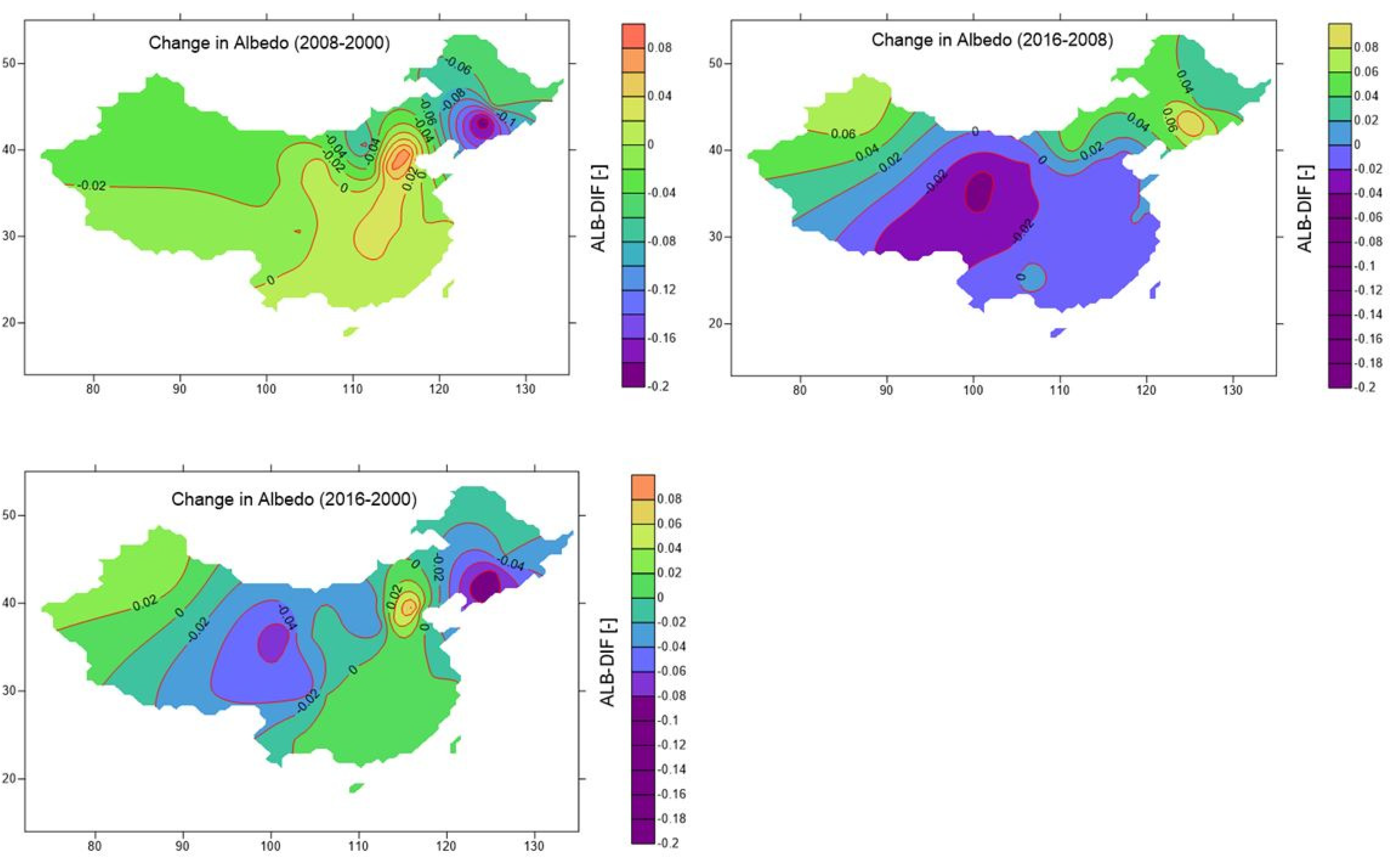
| Provinces | Capital Cities | Location (Lat., Long.) (N, E) | ALB ′00 (-) | ALB ′08 (-) | ALB ′16 (-) | ΔALB (′08-′00) | ΔALB (′16-′08) | ΔALB (′16-′00) |
|---|---|---|---|---|---|---|---|---|
| Anhui | Hefei | 31.5°, 117.2° | 0.11 | 0.13 | 0.12 | 0.02 | −0.01 | 0.01 |
| Beijing | Beijing | 39.5°, 116.2° | 0.13 | 0.22 | 0.22 | 0.08 | 0.00 | 0.09 |
| Chongqing | Chongqing | 29.4°, 106.3° | 0.09 | 0.10 | 0.09 | 0.01 | −0.01 | 0.00 |
| Fujian | Fuzhou | 26.1°, 119.2° | 0.11 | 0.12 | 0.12 | 0.01 | 0.00 | 0.01 |
| Gansu | Lanzhou | 36.0°, 103.5° | 0.24 | 0.24 | 0.22 | 0.00 | −0.02 | −0.02 |
| Guangdong | Guangzhou | 23.1°, 113.1° | 0.11 | 0.12 | 0.12 | 0.01 | 0.00 | 0.00 |
| Guangxi | Nanning | 22.5°, 108.2° | 0.12 | 0.12 | 0.12 | 0.01 | 0.00 | 0.00 |
| Guizhou | Guiyang | 26.4°, 106.4° | 0.10 | 0.10 | 0.11 | 0.01 | 0.00 | 0.01 |
| Hainan | Haikou | 20.0°, 110.2° | 0.14 | 0.14 | 0.14 | 0.00 | 0.00 | 0.00 |
| Hebei | Shijiazhuang | 38.0°, 114.3° | 0.14 | 0.21 | 0.19 | 0.06 | −0.01 | 0.05 |
| Heilongjiang | Harbin | 45.4°, 126.4° | 0.44 | 0.39 | 0.42 | −0.04 | 0.02 | −0.02 |
| Henan | Zhengzhou | 34.5°, 113.4° | 0.11 | 0.13 | 0.12 | 0.03 | −0.02 | 0.01 |
| Hubei | Wuhan | 30.4°, 114.2° | 0.10 | 0.12 | 0.11 | 0.02 | −0.01 | 0.01 |
| Hunan | Changsha | 28.1°, 112.6° | 0.09 | 0.11 | 0.11 | 0.02 | −0.01 | 0.01 |
| Jiangsu | Nanjing | 32.0°, 118.5° | 0.12 | 0.12 | 0.12 | −0.01 | 0.00 | 0.00 |
| Jiangxi | Nanchang | 28.4°, 115.6° | 0.10 | 0.11 | 0.11 | 0.01 | −0.01 | 0.01 |
| Jilin | Changchun | 43.5°, 125.2° | 0.44 | 0.24 | 0.36 | −0.20 | 0.12 | −0.09 |
| Liaoning | Shenyang | 41.5°, 123.3° | 0.32 | 0.18 | 0.23 | −0.15 | 0.06 | −0.09 |
| Inner Mongolia | Hohhot | 40.5°, 111.4° | 0.42 | 0.33 | 0.39 | −0.09 | 0.05 | −0.03 |
| Ningxia | Yinchuan | 38.3°, 106.2° | 0.20 | 0.21 | 0.19 | 0.01 | −0.02 | −0.01 |
| Paracel Islands | Paracel Islands | 16.4°, 112.0° | 0.12 | 0.15 | 0.13 | 0.02 | −0.01 | 0.01 |
| Qinghai | Xining | 36.4°, 101.5° | 0.29 | 0.27 | 0.22 | −0.02 | −0.05 | −0.07 |
| Shaanxi | Taiyuan | 37.5°, 112.3° | 0.18 | 0.14 | 0.14 | −0.04 | 0.00 | −0.03 |
| Shandong | Jinan | 36.4°, 117.0° | 0.13 | 0.14 | 0.14 | 0.01 | −0.01 | 0.00 |
| Shanghai | Shanghai | 31.1°, 121.3° | 0.15 | 0.15 | 0.15 | 0.01 | −0.01 | 0.00 |
| Shanxi | Xian | 34.2°, 108.6° | 0.14 | 0.16 | 0.14 | 0.01 | −0.02 | −0.01 |
| Sichuan | Chengdu | 30.4°, 104.0° | 0.18 | 0.16 | 0.12 | −0.02 | −0.03 | −0.06 |
| Tianjin | Tianjin | 39.0°, 117.1° | 0.10 | 0.12 | 0.11 | 0.02 | −0.02 | 0.00 |
| Xinjiang | Urumqi | 43.5°, 87.4° | 0.34 | 0.31 | 0.38 | −0.03 | 0.07 | 0.04 |
| Tibet | Lhasa | 29.4°, 91.1° | 0.20 | 0.20 | 0.17 | −0.01 | −0.03 | −0.04 |
| Yunnan | Kunming | 25.0°, 102.4° | 0.11 | 0.11 | 0.11 | 0.00 | 0.00 | 0.00 |
| Zhejiang | Hangzhou | 30.2°, 120.1° | 0.10 | 0.11 | 0.11 | 0.01 | −0.01 | 0.01 |
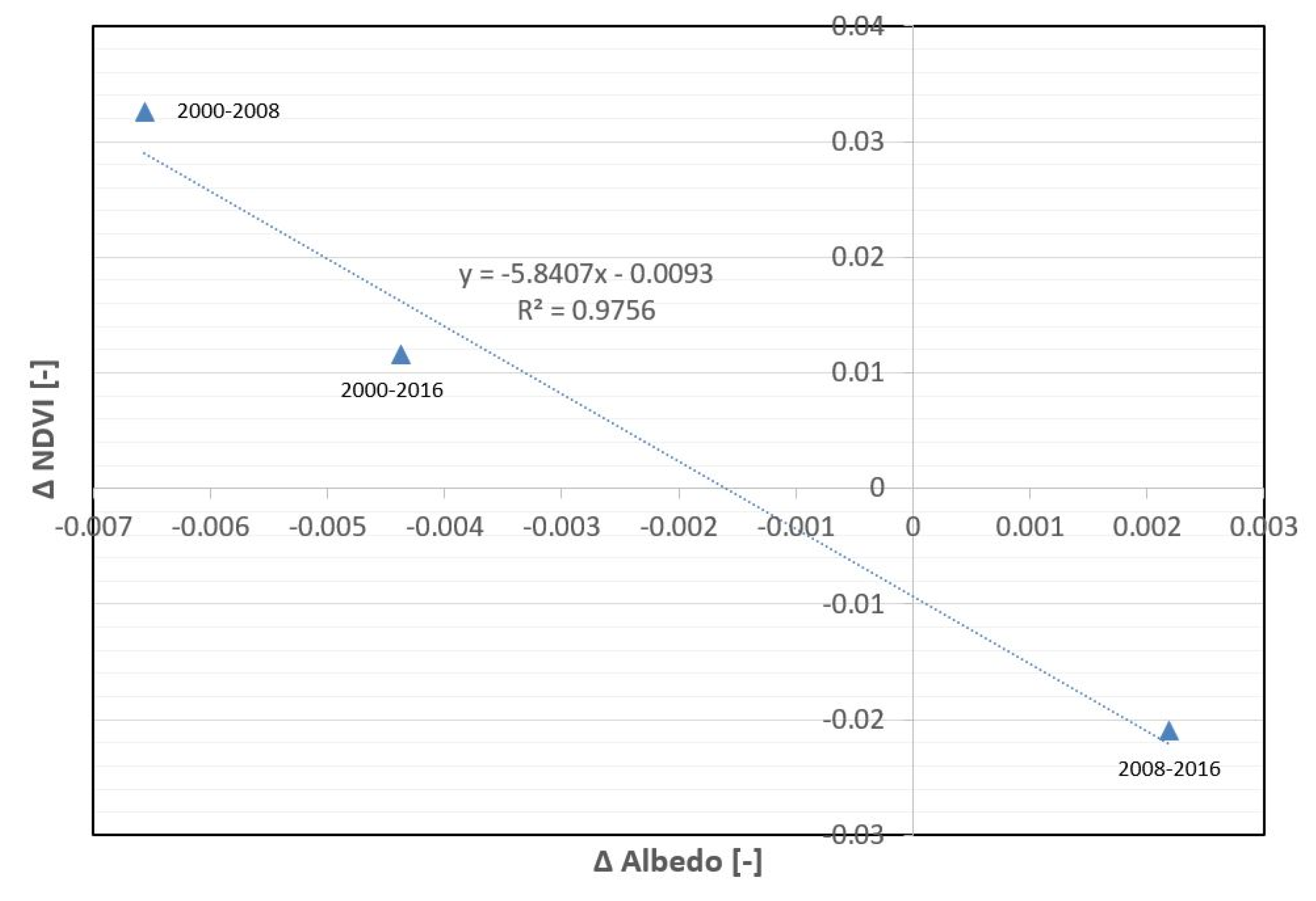
| Mean | 0.177 | 0.171 | 0.173 | −0.006 | 0.002 | −0.004 | ||
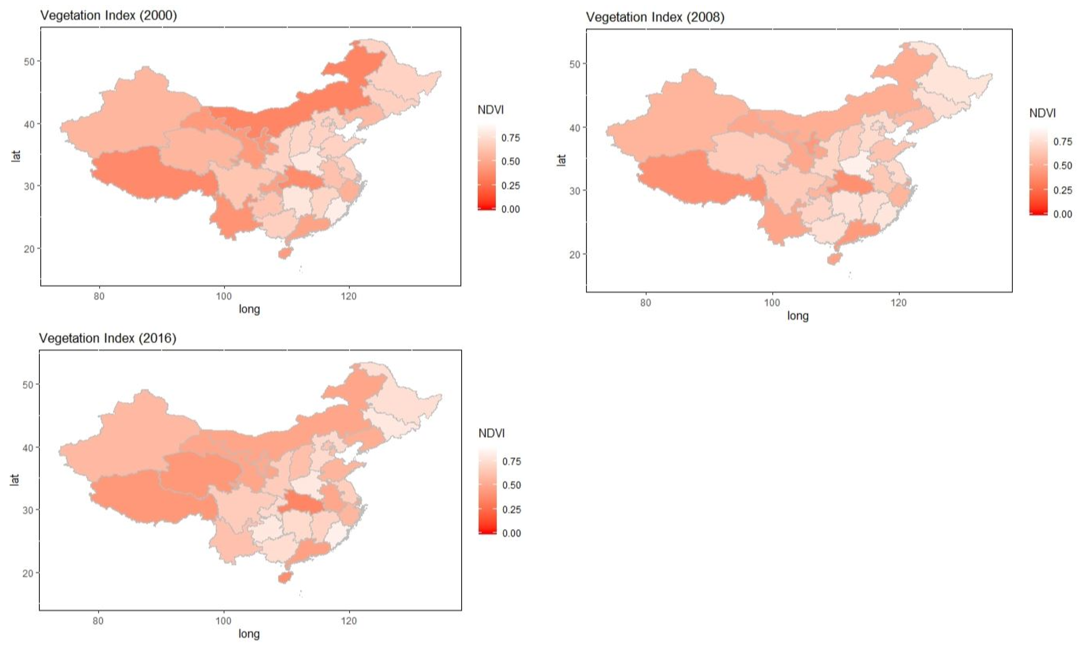
| Provinces | Capital Cities | Location (Lat., Long.) (N, E) | NDVI ′00 (-) | NDVI ′08 (-) | NDVI ′16 (-) | ΔNDVI (′08-′00) | ΔNDVI (′16-‘08) | ΔNDVI (‘16-‘00) |
|---|---|---|---|---|---|---|---|---|
| Anhui | Hefei | 31.5°, 117.2° | 0.61 | 0.64 | 0.49 | 0.03 | −0.15 | −0.12 |
| Beijing | Beijing | 39.5°, 116.2° | 0.67 | 0.72 | 0.62 | 0.05 | −0.1 | −0.05 |
| Chongqing | Chongqing | 29.4°, 106.3° | 0.46 | 0.56 | 0.72 | 0.1 | 0.16 | 0.26 |
| Fujian | Fuzhou | 26.1°, 119.2° | 0.82 | 0.78 | 0.83 | −0.04 | 0.05 | 0.01 |
| Gansu | Lanzhou | 36.0°, 103.5° | 0.43 | 0.49 | 0.48 | 0.06 | −0.01 | 0.05 |
| Guangdong | Guangzhou | 23.1°, 113.1° | 0.47 | 0.43 | 0.46 | −0.04 | 0.03 | −0.01 |
| Guangxi | Nanning | 22.5°, 108.2° | 0.68 | 0.75 | 0.74 | 0.07 | −0.01 | 0.06 |
| Guizhou | Guiyang | 26.4°, 106.4° | 0.62 | 0.69 | 0.79 | 0.07 | 0.1 | 0.17 |
| Hainan | Haikou | 20.0°, 110.2° | 0.44 | 0.47 | 0.38 | 0.03 | −0.09 | −0.06 |
| Hebei | Shijiazhuang | 38.0°, 114.3° | 0.69 | 0.73 | 0.72 | 0.04 | −0.01 | 0.03 |
| Heilongjiang | Harbin | 45.4°, 126.4° | 0.69 | 0.77 | 0.75 | 0.08 | −0.02 | 0.06 |
| Henan | Zhengzhou | 34.5°, 113.4° | 0.79 | 0.83 | 0.79 | 0.04 | −0.04 | 0.00 |
| Hubei | Wuhan | 30.4°, 114.2° | 0.37 | 0.39 | 0.34 | 0.02 | −0.05 | −0.03 |
| Hunan | Changsha | 28.1°, 112.6° | 0.78 | 0.76 | 0.73 | −0.02 | −0.03 | −0.05 |
| Jiangsu | Nanjing | 32.0°, 118.5° | 0.68 | 0.72 | 0.67 | 0.04 | −0.05 | −0.01 |
| Jiangxi | Nanchang | 28.4°, 115.6° | 0.7 | 0.75 | 0.69 | 0.05 | −0.06 | −0.01 |
| Jilin | Changchun | 43.5°, 125.2° | 0.68 | 0.75 | 0.79 | 0.07 | 0.04 | 0.11 |
| Liaoning | Shenyang | 41.5°, 123.3° | 0.57 | 0.58 | 0.52 | 0.01 | −0.06 | −0.05 |
| Inner Mongolia | Hohhot | 40.5°, 111.4° | 0.34 | 0.52 | 0.48 | 0.18 | −0.04 | 0.14 |
| Ningxia | Yinchuan | 38.3°, 106.2° | 0.41 | 0.43 | 0.5 | 0.02 | 0.07 | 0.09 |
| Paracel Islands | Paracel Islands | 16.4°, 112.0° | 0.66 | 0.84 | 0.71 | 0.18 | −0.13 | 0.05 |
| Qinghai | Xining | 36.4°, 101.5° | 0.56 | 0.66 | 0.42 | 0.1 | −0.24 | −0.14 |
| Shaanxi | Taiyuan | 37.5°, 112.3° | 0.69 | 0.7 | 0.66 | 0.01 | −0.04 | −0.03 |
| Shandong | Jinan | 36.4°, 117.0° | 0.69 | 0.62 | 0.55 | −0.07 | −0.07 | −0.14 |
| Shanghai | Shanghai | 31.1°, 121.3° | 0.58 | 0.46 | 0.48 | −0.12 | 0.02 | −0.1 |
| Shanxi | Xian | 34.2°, 108.6° | 0.71 | 0.66 | 0.6 | −0.05 | −0.06 | −0.11 |
| Sichuan | Chengdu | 30.4°, 104.0° | 0.63 | 0.65 | 0.66 | 0.02 | 0.01 | 0.03 |
| Tianjin | Tianjin | 39.0°, 117.1° | 0.68 | 0.67 | 0.59 | −0.01 | −0.08 | −0.09 |
| Xinjiang | Urumqi | 43.5°, 87.4° | 0.56 | 0.55 | 0.57 | −0.01 | 0.02 | 0.01 |
| Tibet | Lhasa | 29.4°, 91.1° | 0.36 | 0.39 | 0.42 | 0.03 | 0.03 | 0.06 |
| Yunnan | Kunming | 25.0°, 102.4° | 0.4 | 0.48 | 0.61 | 0.08 | 0.13 | 0.21 |
| Zhejiang | Hangzhou | 30.2°, 120.1° | 0.53 | 0.55 | 0.56 | 0.02 | 0.01 | 0.03 |
| Mean | 0.592 | 0.625 | 0.604 | 0.033 | −0.021 | 0.012 | ||
© 2020 by the author. Licensee MDPI, Basel, Switzerland. This article is an open access article distributed under the terms and conditions of the Creative Commons Attribution (CC BY) license (http://creativecommons.org/licenses/by/4.0/).
Share and Cite
Yuan, J. Investigation of Spatial and Temporal Changes in the Land Surface Albedo for the Entire Chinese Territory. Geosciences 2020, 10, 362. https://doi.org/10.3390/geosciences10090362
Yuan J. Investigation of Spatial and Temporal Changes in the Land Surface Albedo for the Entire Chinese Territory. Geosciences. 2020; 10(9):362. https://doi.org/10.3390/geosciences10090362
Chicago/Turabian StyleYuan, Jihui. 2020. "Investigation of Spatial and Temporal Changes in the Land Surface Albedo for the Entire Chinese Territory" Geosciences 10, no. 9: 362. https://doi.org/10.3390/geosciences10090362
APA StyleYuan, J. (2020). Investigation of Spatial and Temporal Changes in the Land Surface Albedo for the Entire Chinese Territory. Geosciences, 10(9), 362. https://doi.org/10.3390/geosciences10090362


