Long-Term Displacement Monitoring of Slow Earthflows by Inclinometers and GPS, and Wide Area Surveillance by COSMO-SkyMed Data

 , ,
, , 
Abstract
1. Introduction
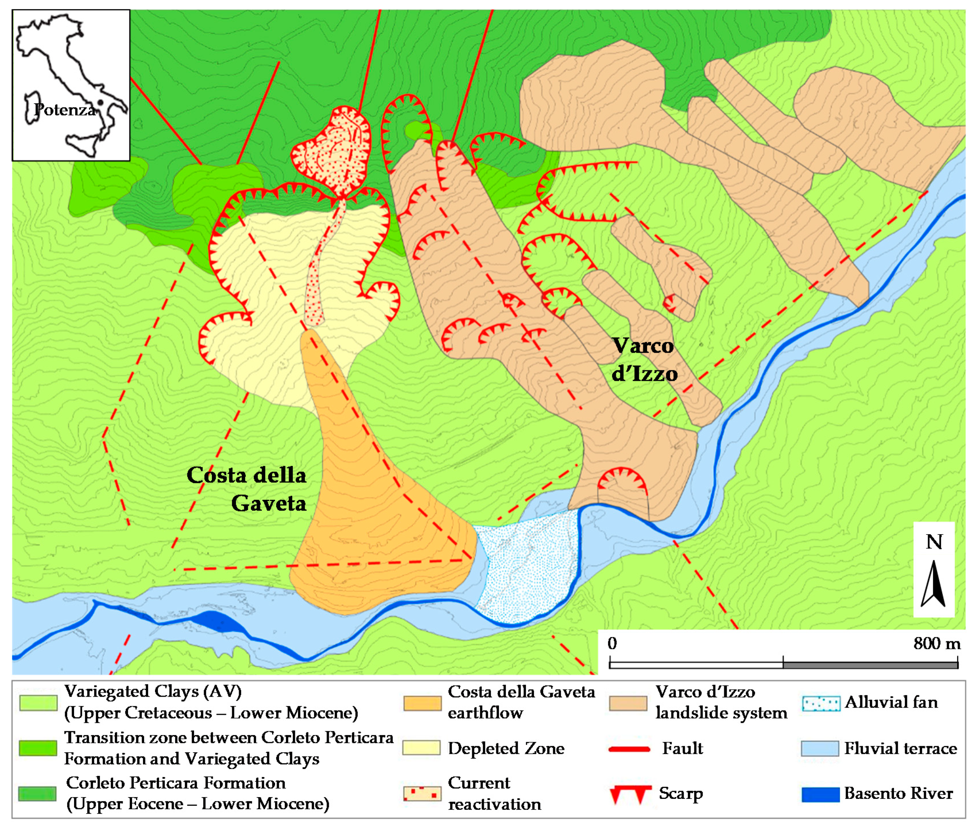
2. Geological and Geomorphological Outline
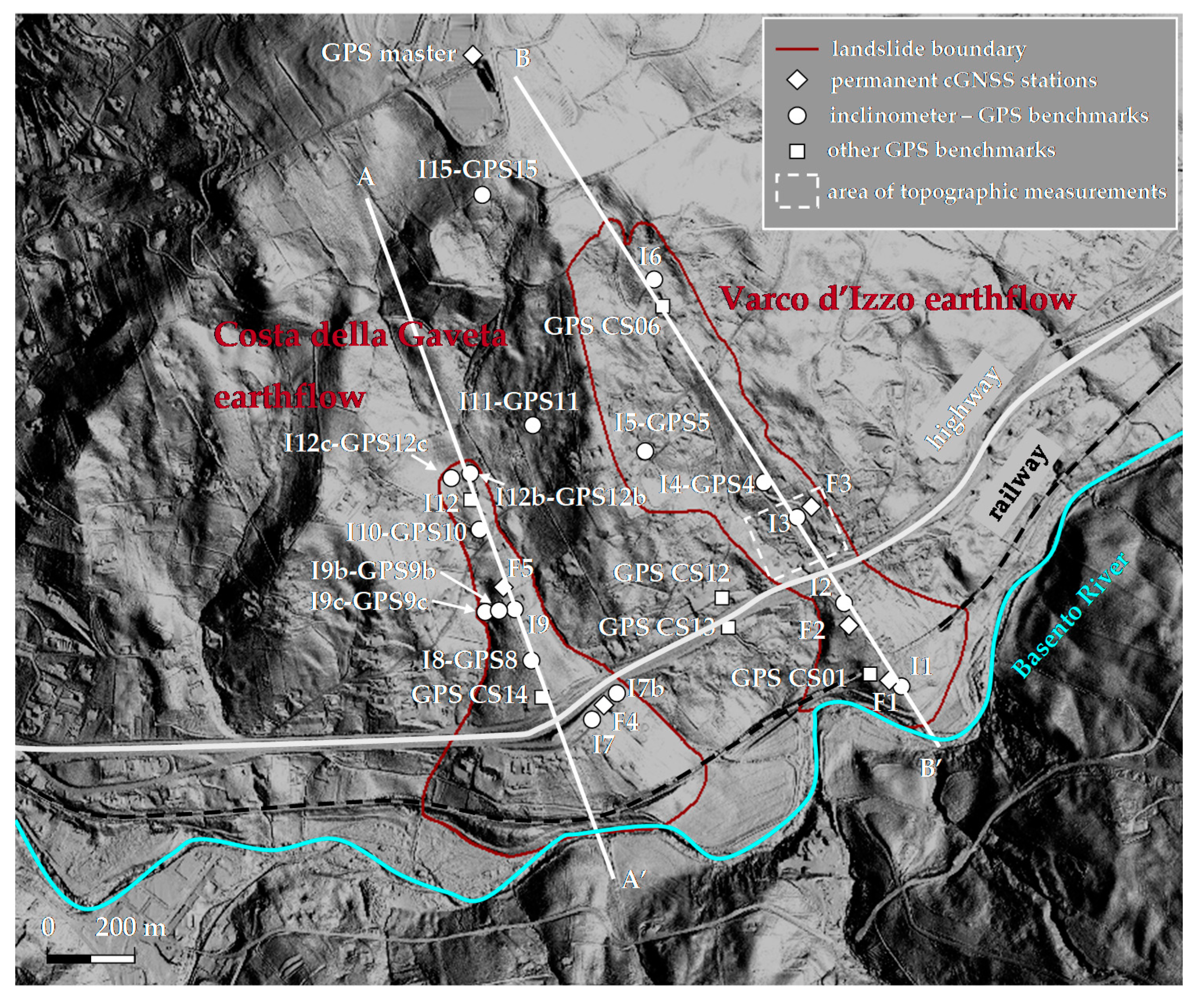
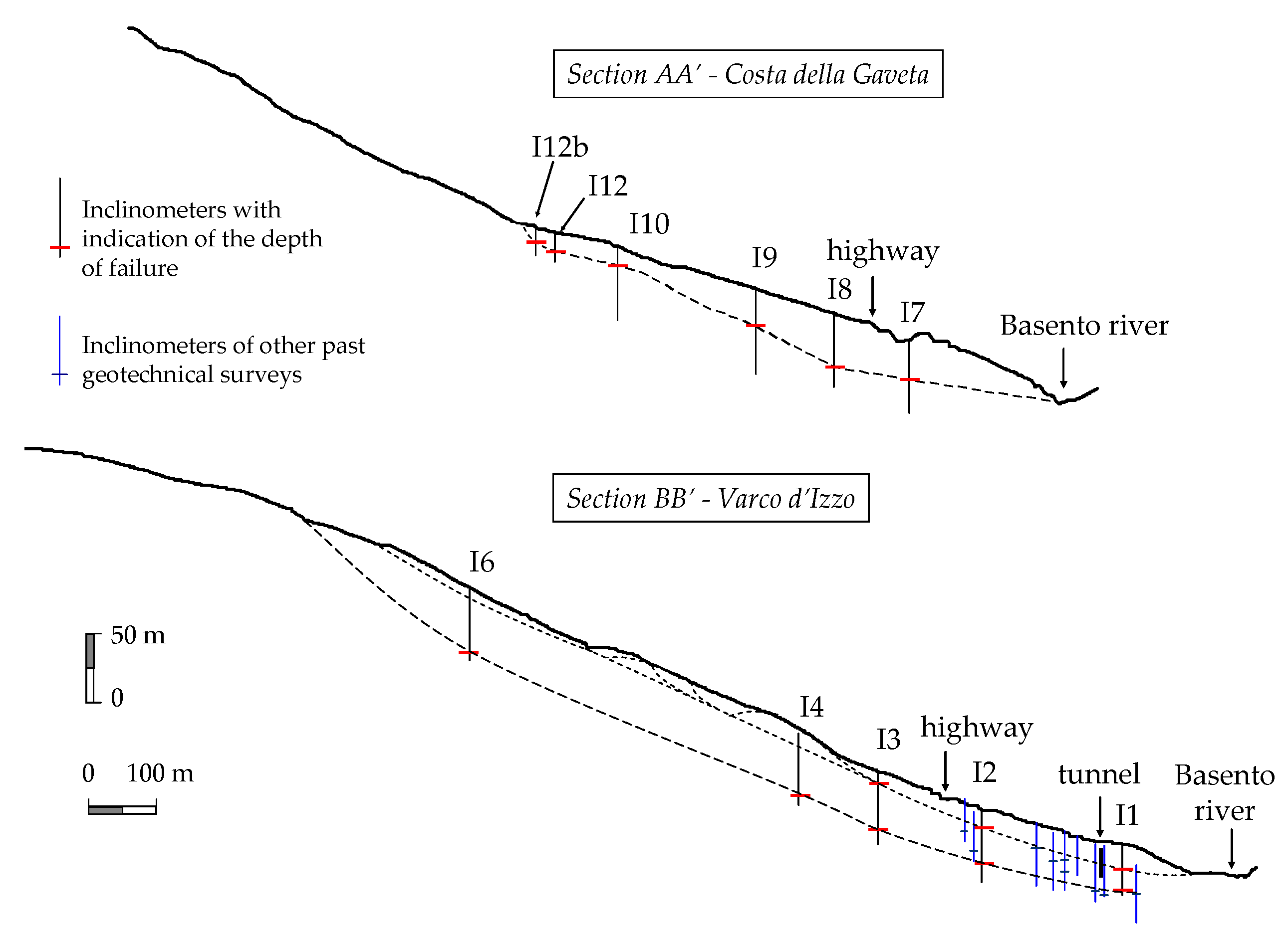
3. Inclinometer Measurements
3.1. Methods
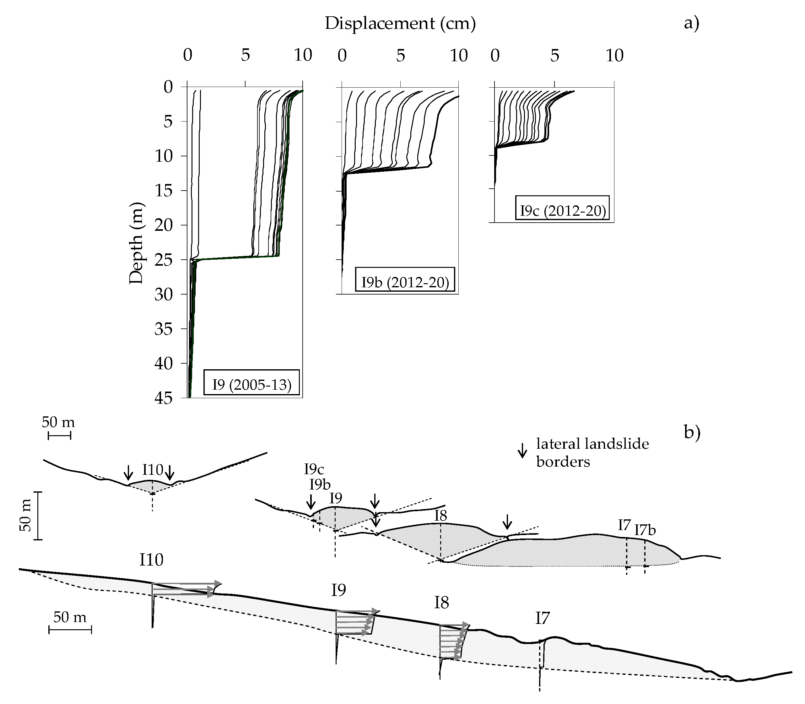
3.2. Results
4. GPS Data
4.1. Methods
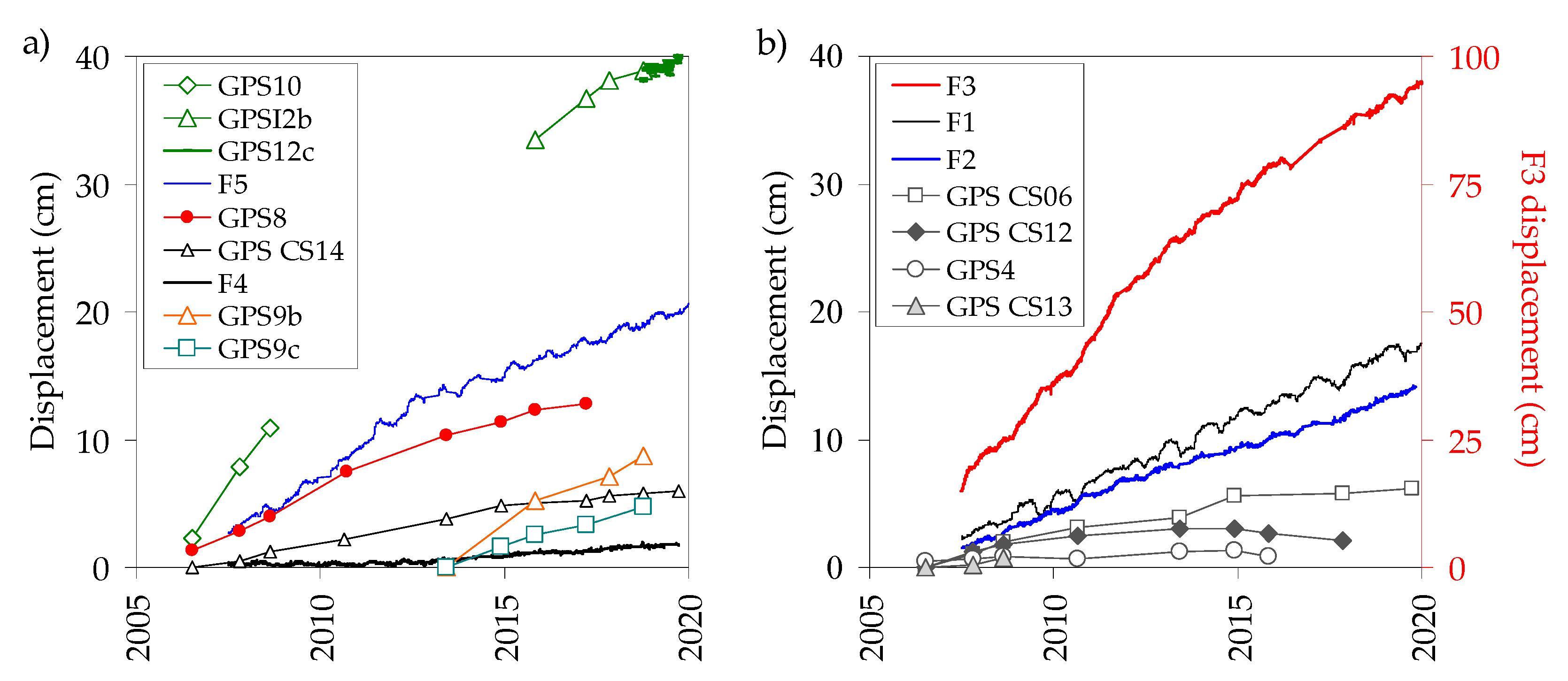
4.2. Results
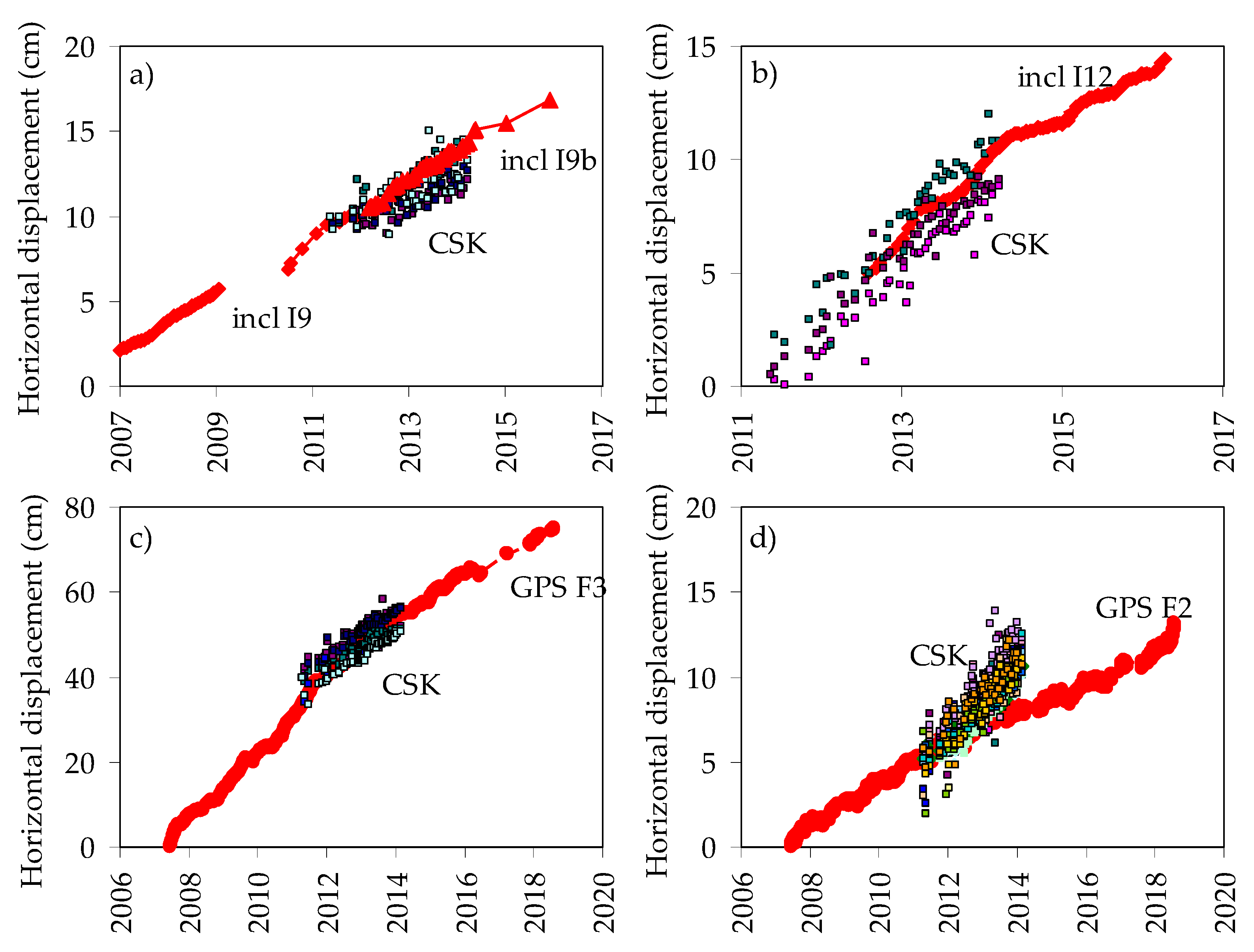
5. PSInSAR Data and Comparison with GPS and Inclinometer Data
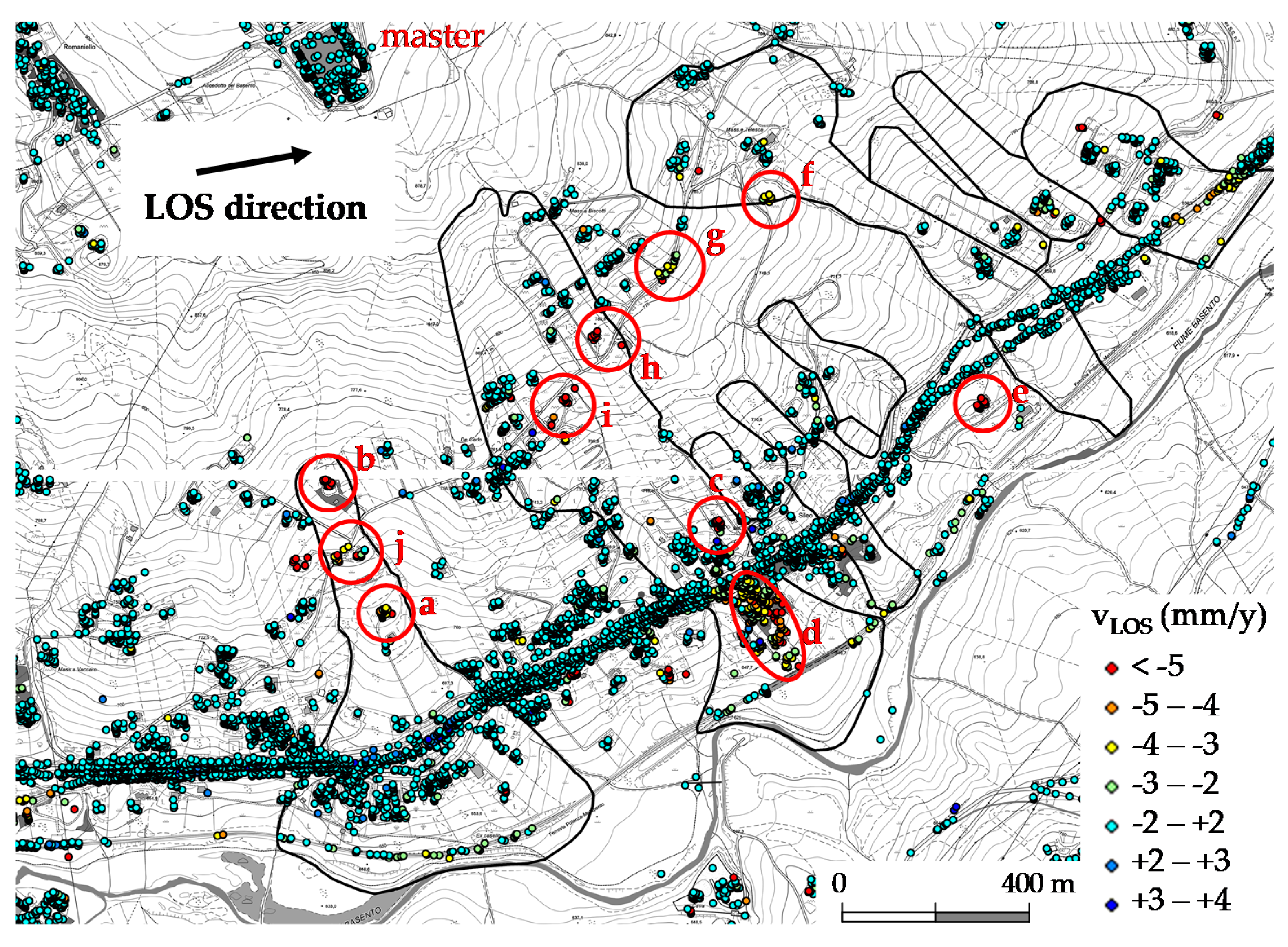
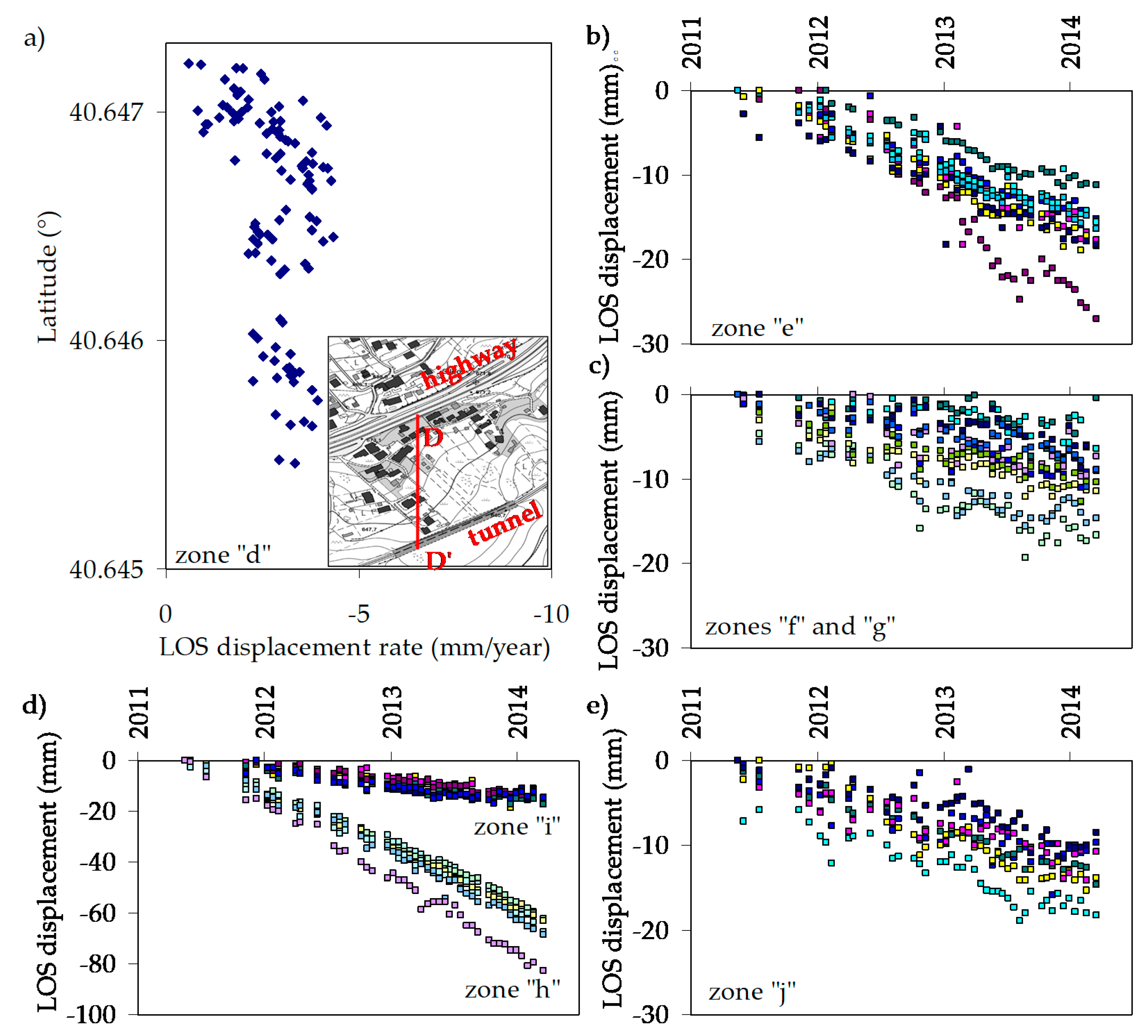
6. Displacement Field
7. Conclusions
Author Contributions
Funding
Acknowledgments
Conflicts of Interest
References
- Esu, F. Behaviour of Slopes in Structurally Complex Formations; AGI, General Report, Int. Symp. on the Geotechnics of Structurally Complex Formations: Capri, Italy, 1977; Volume 2, pp. 292–304. [Google Scholar]
- Trigila, A. (Ed.) Report on landslides in Italy. In Italian Landslide Inventory: Methods, Results and Regional Reports; Project IFFI (in Italian). APAT: Roma, Italy, 2007; p. 681. [Google Scholar]
- Revellino, P.; Grelle, G.; Donnarumma, A.; Guadagno, F.M. Structurally-controlled earth flows of the Benevento Province (Southern Italy). Bull. Eng. Geol. Environ. 2010, 69, 487–500. [Google Scholar] [CrossRef]
- Pellegrino, A.; Ramondini, M.; Urciuoli, G. Interplay between morphology and mechanism of mudslides: Field experiences from Southern Italy. In Landslides: Evaluation and Stvailization, Proceedings of the 9th International Symposium on Landslides, Rio de Janeiro, Brasil, June 28–July 2 2004; Lacerda, W., Ehrlich, M., Fontoura, S.A.B., Sayao, A.S.F., Eds.; Taylor & Francis Group: London, UK, 2004; Volume 2, pp. 1403–1409. [Google Scholar]
- Guida, G.; Iaccarino, G. Fasi evolutive delle frane tipo colata nell’alta valle del F.Basento (Potenza). Proc. Studi Trentini Sci. Nat. Acta Geol. 1991, 68, 127–152. [Google Scholar]
- Hungr, O.; Leroueil, S.; Picarelli, L. The Varnes classification of landslide types, an update. Landslides 2014, 11, 67–194. [Google Scholar] [CrossRef]
- Urciuoli, G.; Comegna, L.; Di Maio, C.; Picarelli, L. The Basento Valley: A natural laboratory to understand the mechanics of earthflows. Riv. Ital. Geotech. 2016, 50, 71–90. [Google Scholar]
- Guerriero, L.; Bertello, L.; Cardozo, N.; Berti, M.; Grelle, G.; Revellino, P. Unsteady sediment discharge in earth flows: Mount Pizzuto earthflow, southern Italy. Geomorphology 2017, 295, 260–284. [Google Scholar] [CrossRef]
- Iverson. Regulation of landslide motion by dilatancy and pore pressure feedback. J. Geophys. Res. 2005, 110, F02015. [Google Scholar]
- Schulz, W.H.; McKenna, J.P.; Kibler, J.D.; Biavati, G. Relations between hydrology and velocity of a continuously moving landslide—Evidence of pore-pressure feedback regulating landslide motion? Landslides. 2009, 6, 181–190. [Google Scholar] [CrossRef]
- Handwerger, A.L.; Roering, J.J.; Schmidt, D.A. Controls on the seasonal deformation of slow-moving landslides. Earth Planet. Sci. Lett. 2013, 377–378, 239–247. [Google Scholar] [CrossRef]
- Guerriero, L.; Diodato, N.; Fiorillo, F.; Revellino, P.; Grelle, G.; Guadagno, F.M. Reconstruction of long-term earth-flow activity using a hydro-climatological model. Nat. Hazards 2015, 77, 1–15. [Google Scholar] [CrossRef]
- Di Maio, C.; De Rosa, J.; Vassallo, R.; Coviello, R.; Macchia, G. Hydraulic conductivity and pore water pressures in a clayey earthflow: Experimental data. Geosciences 2020, 10, 102. [Google Scholar] [CrossRef]
- Mackey, B.; Roering, J.J. Sediment yield, spatial characteristics, and the long-term evolution of active earthflows determined from airborne LiDAR and historical aerial photographs, Eel River, California. Gsa Bull. 2011, 123, 1560–1576. [Google Scholar] [CrossRef]
- Del Soldato, M.; Riquelme, A.; Bianchini, S.; Tomàs, R.; Di Martire, D.; De Vita, P.; Moretti, S.; Calcaterra, D. Multisource data integration to investigate one century of evolution for the Agnone landslide (Molise, southern Italy). Landslides 2018, 15, 2113–2128. [Google Scholar] [CrossRef]
- Akbarimehr, M.; Motagh, M.; Haghshenas Haghighi, M. Slope Stability Assessment of the Sarcheshmeh Landslide, Northeast Iran, Investigated Using InSAR and GPS Observations. Remote Sens. 2013, 5, 3681–3700. [Google Scholar] [CrossRef]
- Farolfi, G.; Bianchini, S.; Casagli, N. Integration of GNSS and satellite InSAR data: Derivation of fine-scale vertical surface motion maps of Po Plain, Northern Apennines and Southern Alps, Italy. IEEE Trans. Geosc. Rem. Sens. (Tgrs) 2018, 57, 319–328. [Google Scholar] [CrossRef]
- Farolfi, G.; Piombino, A.; Catani, F. Fusion of GNSS and satellite radar interferometry: Determination of 3D fine-scale map of present-day surface displacements in Italy as expressions of geodynamics processes. Remote Sens. 2019, 11, 394. [Google Scholar] [CrossRef]
- Gullà, G.; Peduto, D.; Borrelli, L.; Antronico, L.; Fornaro, G. Geometric and kinematic characterization of landslides affecting urban areas: The Lungro case study (Calabria, Southern Italy). Landslides 2017, 14, 171–188. [Google Scholar] [CrossRef]
- Di Maio, C.; Fornaro, G.; Gioia, D.; Reale, D.; Schiattarella, M.; Vassallo, R. In situ and satellite long-term monitoring of the Latronico landslide, Italy: Displacement evolution, damage to buildings, and effectiveness of remedial works. Eng. Geol. 2018, 245, 218–235. [Google Scholar] [CrossRef]
- Calvello, M.; Peduto, D.; Arena, L. Combined use of statistical and DInSAR data analyses to define the state of activity of slow-moving landslides. Landslides 2017, 14, 473–489. [Google Scholar] [CrossRef]
- Di Maio, C.; Vassallo, R.; Vallario, M. Plastic and viscous displacements of a deep and very slow landslide in stiff clay formation. Eng. Geol. 2013, 162, 53–66. [Google Scholar] [CrossRef]
- Di Maio, C.; Scaringi, G.; Vassallo, R. Residual strength and creep behaviour on the slip surface of specimens of a landslide in marine origin clay shales: Influence of pore fluid composition. Landslides 2015, 12, 657–667. [Google Scholar] [CrossRef]
- Di Maio, C.; Vassallo, R.; Scaringi, G.; De Rosa, J.; Pontolillo, D.M.; Grimaldi, G.M. Monitoring and analysis of an earthflow in tectonized clay shales and study of a remedial intervention by KCl wells. Riv. Ital. Geotech. 2017, 51, 48–63. [Google Scholar]
- Minardo, A.; Picarelli, L.; Catalano, E.; Coscetta, A.; Zeni, G.; Zhang, L.; Di Maio, C.; Vassallo, R.; Coviello, R.; Macchia, G.; et al. Distributed Fiber Optic Sensors for the Monitoring of a Tunnel Crossing a Landslide. Remote Sens. 2018, 10, 1291. [Google Scholar] [CrossRef]
- Caniani, D.; Pascale, S.; Sdao, F.; Sole, A. Neural networks and landslide susceptibility: A case study of the urban area of Potenza. Nat. Hazards. 2008, 45, 55–72. [Google Scholar] [CrossRef]
- Mazzoli, S.; Barkham, S.; Cello, G.; Gambini, R.; Mattioni, L.; Shiner, P.; Tondi, E. Reconstruction of continental margin architecture deformed by the contraction of the Lagonegro Basin, southern Apennines, Italy. J. Geol. Soc. 2001, 158, 309–319. [Google Scholar] [CrossRef]
- Cello, G.; Coccia, B.; Mancinelli, A.; Mattioni, L.; Mazzoli, S.; Shiner, P. Architettura pre-orogenica della piatta-forma carbonatica appenninica nell’alta Val d’Agri (Lucania, Italia meridionale). Studi Geol. Camerti 2003, 2, 45–52. [Google Scholar]
- Pescatore, T.; Renda, P.; Schiattarella, M.; Tramutoli, M. Stratigraphic and structural relationships between Meso-cenozoic Lagonegro basin and coeval carbonate plat-forms in southern Italy. Tectonophysics 1999, 315, 286–295. [Google Scholar] [CrossRef]
- Ogniben, L. Schema introduttivo alla Geologia del confine Calabro-Lucano. Mem. Della Soc. Geol. Ital. 1969, 8, 453–763. [Google Scholar]
- Selli, R. II Paleogene nel quadro della geologia dell’Italia centro meridionale. Mem. Della Soc. Geol. Ital. 1962, 3, 737–789. [Google Scholar]
- Vassallo, R.; Grimaldi, G.M.; Di Maio, C.; Di Nocera, S. An earthflow in structurally complex formations of the Italian Southern Apennines: Geological structure and kinematics. In Landslides and Engineered Slopes, Experience, Theory and Practice, Proceedings of the 12th International Symposium on Landslides, Napoli, Italy, 12–19 June 2016; Aversa, S., Cascini, L., Picarelli, L., Scavia, C., Eds.; CRC Press: Boca Raton, FL, USA, 2016; Volume 2, pp. 813–820. [Google Scholar]
- Perrone, A.; Iannuzzi, A.; Lapenna, V.; Lorenzo, P.; Piscitelli, S.; Rizzo, E.; Sdao, F. High-resolution electrical imaging of the Varco d’Izzo earthflow (southern Italy). J. Appl. Geophys. 2004, 56, 17–29. [Google Scholar] [CrossRef]
- Vassallo, R.; Mishra, M.; Santarsiero, G.; Masi, A. Modeling of Landslide–Tunnel Interaction: The Varco d’Izzo Case Study. Geotech. Geol. Eng. 2019, 37, 5507–5531. [Google Scholar] [CrossRef]
- Stark, T.D.; Choi, H. Slope inclinometers for landslides. Landslides 2008, 5, 339–350. [Google Scholar] [CrossRef]
- ASTM. Standard Test Method for Monitoring Ground Movement Using Probe-Type Inclinometers. ASTM D6230-98. Annual Book of ASTM Standards; ASTM international: West Conshohocken, PA, USA, 2005. [Google Scholar]
- Machan, G.; Bennet, V.G. Use of Inclinometers for Geotechnical Instrumentation on Transportation Projects. State of the Practice. Circular n. E-C129; Transportation Research Board of the National Academies: Washington, DC, USA, 2008. [Google Scholar]
- Keefer, D.K.; Johnson, A.M. Earthflows: Morphology, Mobilization and Movement; U.S. Geological Survey Professional Paper 1264; U.S. Geological Survey: Reston, VA, USA, 1983; p. 56.
- Baum, R.L.; Johnson, A.M. Steady Movement of Landslide Features in Fine-Grained Soils—A Model for Sliding over an Irregular Slip Surface; Chapter D of landslide processes in Utah—Observation and theory; U.S. Geological Survey Bulletin 1842; U.S. Geological Survey: Reston, VA, USA, 1993; pp. D1–D28.
- Guerriero, L.; Coe, J.A.; Revellino, P.; Grelle, G.; Pinto, F.; Guadagno, F.M. Influence of slip-surface geometry on earth-flow deformation, Montaguto earth flow, southern Italy. Geomorphology 2014, 219, 285–305. [Google Scholar] [CrossRef]
- Di Maio, C.; Vassallo, R.; Vallario, M.; Pascale, S.; Sdao, F. Structure and kinematics of a landslide in a complex clayey formation of the Italia Southern Apennines. Eng. Geol. 2010, 116, 311–322. [Google Scholar] [CrossRef]
- Di Maio, C.; Vallario, M.; Vassallo, R.; Bianca, M. Displacements of a large landslide in structurally complex clays. In Landslides and Engineered Slopes: Protecting Society through Improved Understanding, Proceedings of the 11th International Symposium on Landslides, Banff, AB, Canada, 3–8 June 2012; Eberhardt, E., Froese, C., Turner, A.K., Leroueil, S., Eds.; CRC Press, Taylor & Francis Group: London, UK, 2012; Volume 1, pp. 607–613. [Google Scholar]
- D’Agostino, N. Complete seismic release of tectonic strain and earthquake recurrence in the Apennines (Italy). Geophys. Res. Lett. 2014, 41, 1155–1162. [Google Scholar] [CrossRef]
- Calcaterra, S.; Di Maio, C.; Gambino, P.; Vallario, M.; Vassallo, R. Surface displacements of two landslides evaluated by GPS and inclinometer systems: A case study in Southern Apennines, Italy. Nat. Hazards 2012, 61, 257–266. [Google Scholar] [CrossRef]
- Bertiger, W.; Desai, S.; Haines, B.; Harvey, N.; Moore, A.; Owen, S.; Weiss, J. Single receiver phase ambiguity resolution with GPS data. J. Geod. 2010, 84, 327–337. [Google Scholar] [CrossRef]
- Scherneck, H.G. A parameterized solid earth tide model and ocean tide loading effects for global geodetic baseline measurements. Geophys. J. Int. 1991, 106, 677–694. [Google Scholar] [CrossRef]
- Rebischung, P.; Altamimi, Z.; Ray, J.; Garayt, B. The IGS contribution to ITRF2014. J. Geod. 2016, 90, 611–630. [Google Scholar] [CrossRef]
- Dach, R.; Hugentobler, U.; Fridez, P.; Meindl, M. Bernese GPS Software Version 5.0; Astronomical Institute, University of Bern: Bern, Switzerland, 2007. [Google Scholar]
- Di Maio, C.; Vassallo, R.; Vallario, M.; Calcaterra, S.; Gambino, P. Surface and deep displacements evaluated by GPS and inclinometers in a clayey slope. In Landslide Science and Practice, Proceedings of the 2nd World Landslide Forum, Rome, Italy, 3–9 October 2011; Margottini, C., Canuti, P., Sassa, K., Eds.; Springer: Berlin/Heidelberg, Germany, 2013; Volume 2, pp. 265–271. [Google Scholar]
- Costantini, M.; Ferretti, A.; Minati, F.; Falco, S.; Trillo, F.; Colombo, D.; Novali, F.; Malvarosa, F.; Mammone, C.; Vecchioli, F.; et al. Analysis of surface deformations over the whole Italian territory by interferometric processing of ERS, Envisat and COSMO-SkyMed radar data. Remote Sens. Environ. 2017, 202, 250–275. [Google Scholar] [CrossRef]
- Vassallo, R.; Doglioni, A.; Grimaldi, G.M.; Di Maio, C.; Simeoni, V. Relationships between rain and displacements of an active earth flow: A data driven approach by EPRMOGA. Nat. Hazards 2016, 81, 1467–1482. [Google Scholar] [CrossRef]
- Parise, M. Observation of surface features on an active landslide, and implications for understanding its history of movement. Nat. Hazards Earth Syst. Sci. 2003, 3, 569–580. [Google Scholar] [CrossRef]
- Baum, R.L.; Reid, M.R. Ground water isolation by low-permeability clays in landslide shear zones. In Landslides in Research, Theory and Practice, Proceedings of the 8th International Symposium on Landslides, Cardiff, UK, 26–30 June 2000; Bromhead, E., Dixon, N., Ibsen, M.-L., Eds.; Thomas Telford: London, UK, 2000; pp. 139–144. [Google Scholar]


© 2020 by the authors. Licensee MDPI, Basel, Switzerland. This article is an open access article distributed under the terms and conditions of the Creative Commons Attribution (CC BY) license (http://creativecommons.org/licenses/by/4.0/).
Share and Cite
Vassallo, R.; Calcaterra, S.; D’Agostino, N.; De Rosa, J.; Di Maio, C.; Gambino, P. Long-Term Displacement Monitoring of Slow Earthflows by Inclinometers and GPS, and Wide Area Surveillance by COSMO-SkyMed Data. Geosciences 2020, 10, 171. https://doi.org/10.3390/geosciences10050171
Vassallo R, Calcaterra S, D’Agostino N, De Rosa J, Di Maio C, Gambino P. Long-Term Displacement Monitoring of Slow Earthflows by Inclinometers and GPS, and Wide Area Surveillance by COSMO-SkyMed Data. Geosciences. 2020; 10(5):171. https://doi.org/10.3390/geosciences10050171
Chicago/Turabian StyleVassallo, Roberto, Stefano Calcaterra, Nicola D’Agostino, Jacopo De Rosa, Caterina Di Maio, and Piera Gambino. 2020. "Long-Term Displacement Monitoring of Slow Earthflows by Inclinometers and GPS, and Wide Area Surveillance by COSMO-SkyMed Data" Geosciences 10, no. 5: 171. https://doi.org/10.3390/geosciences10050171
APA StyleVassallo, R., Calcaterra, S., D’Agostino, N., De Rosa, J., Di Maio, C., & Gambino, P. (2020). Long-Term Displacement Monitoring of Slow Earthflows by Inclinometers and GPS, and Wide Area Surveillance by COSMO-SkyMed Data. Geosciences, 10(5), 171. https://doi.org/10.3390/geosciences10050171