Topographic Thresholds and Soil Preservation along the Southern High Plains Eastern Escarpment, Northwest Texas, USA


Abstract
1. Introduction
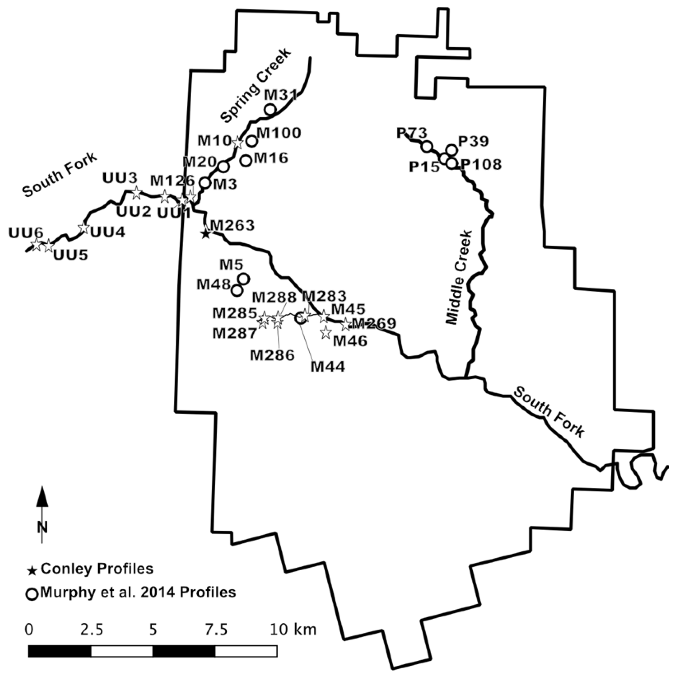
Research Area
2. Materials and Methods
2.1. Soil and Sediment Analysis
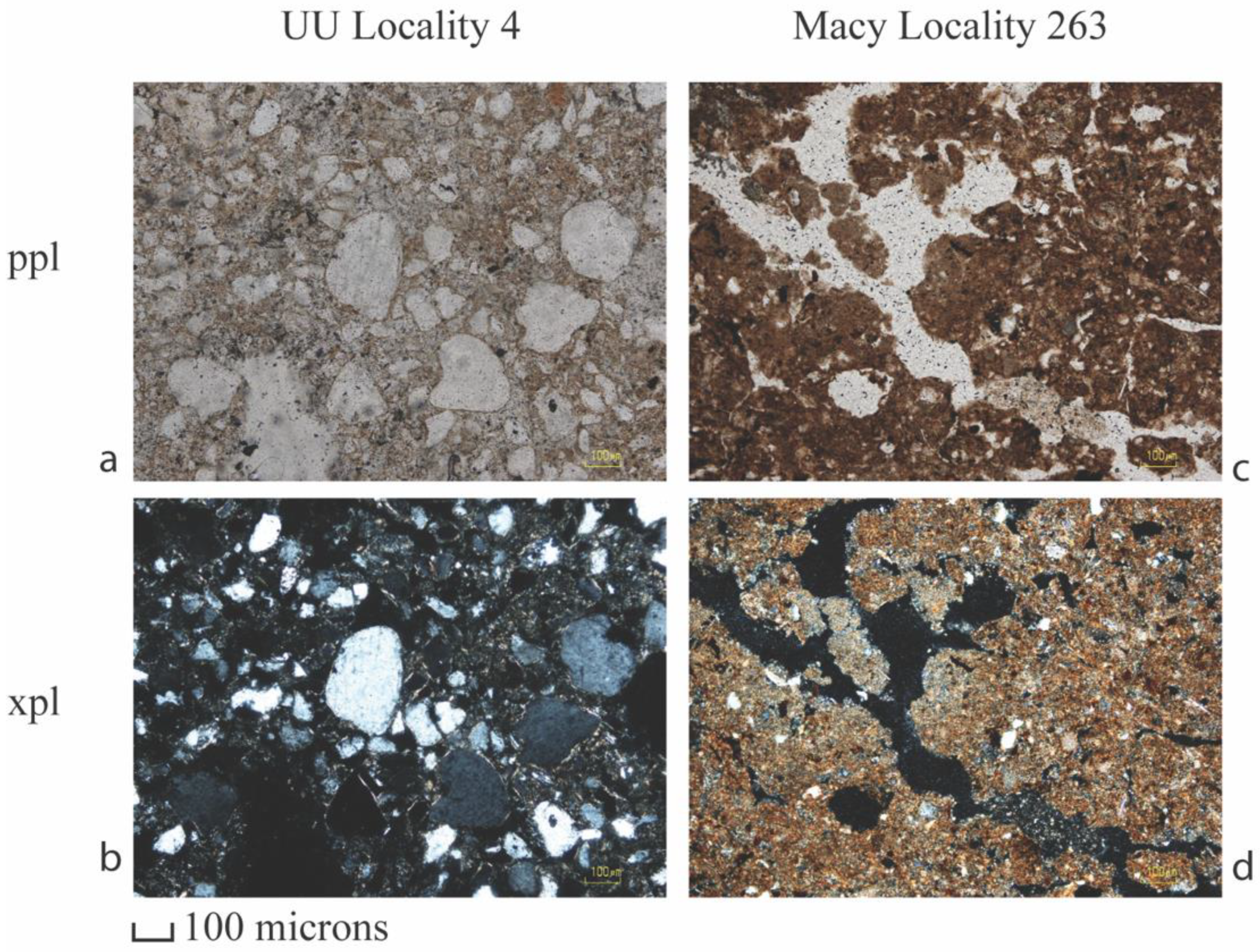
2.2. Thin-Section Analysis
2.3. Radiocarbon Dating
2.4. Topographic Threshold Analysis
3. Results
3.1. Pedological Analysis
3.1.1. Late-Pleistocene to Early Holocene Soils
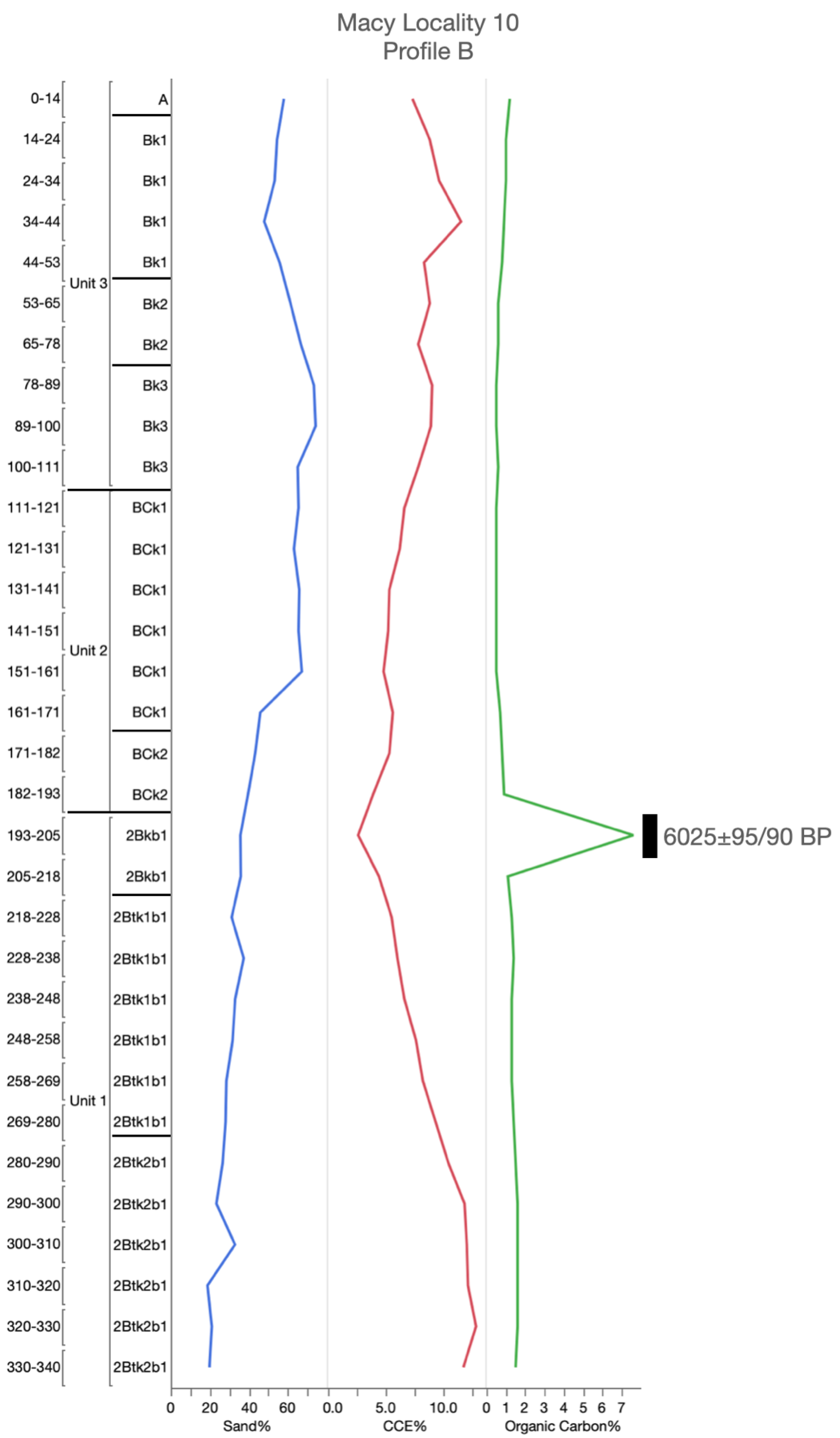
3.1.2. Middle-Holocene Soil
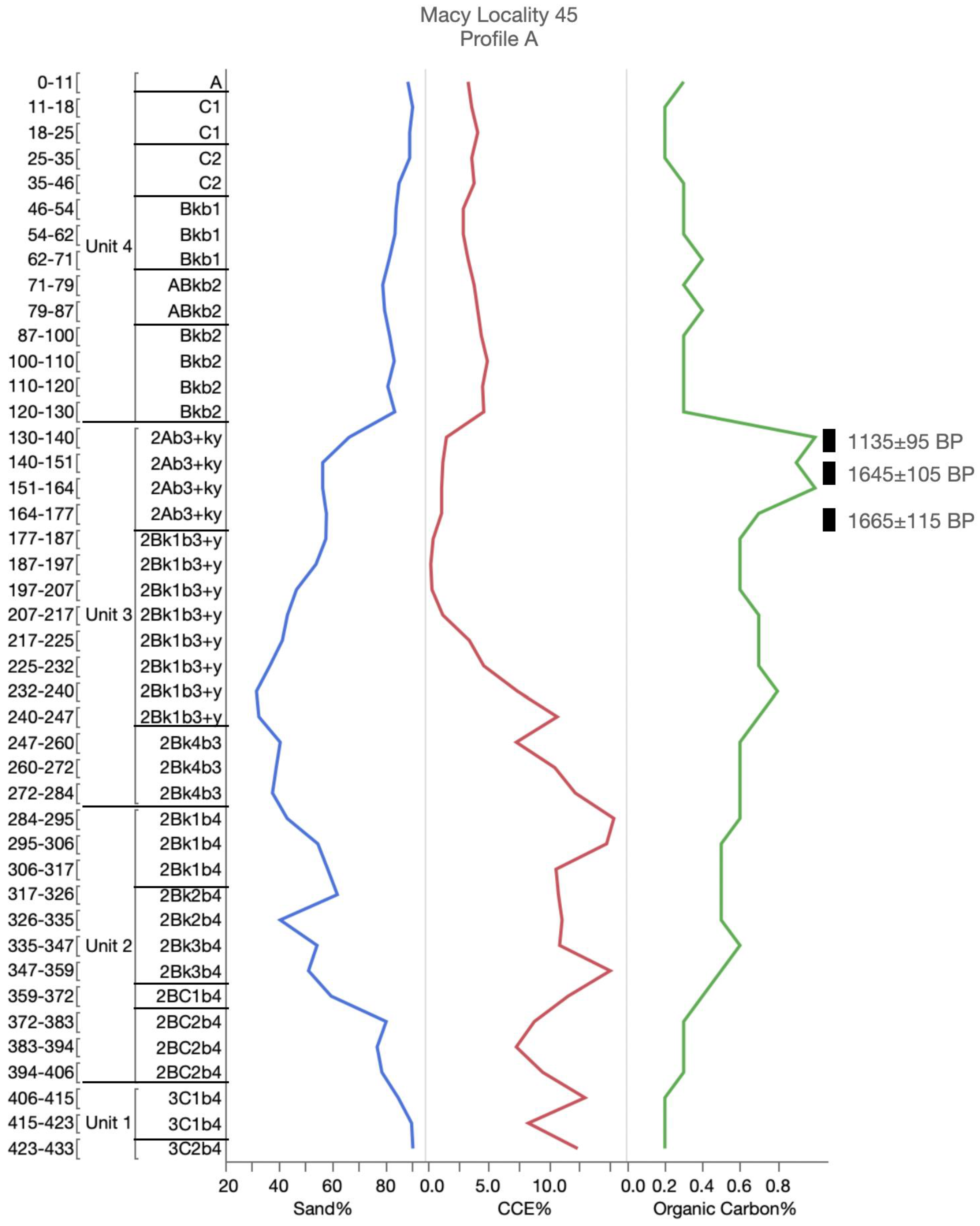
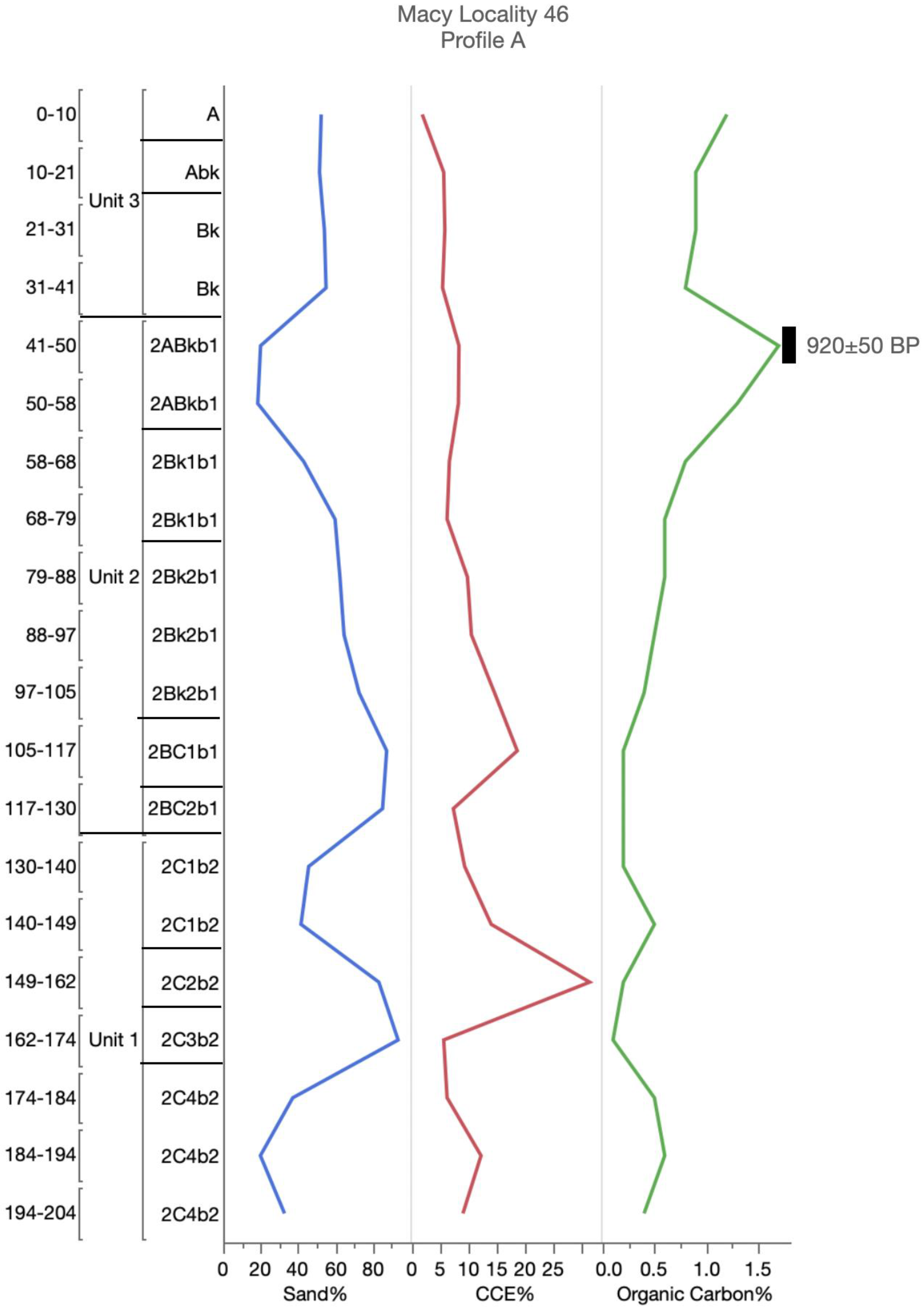
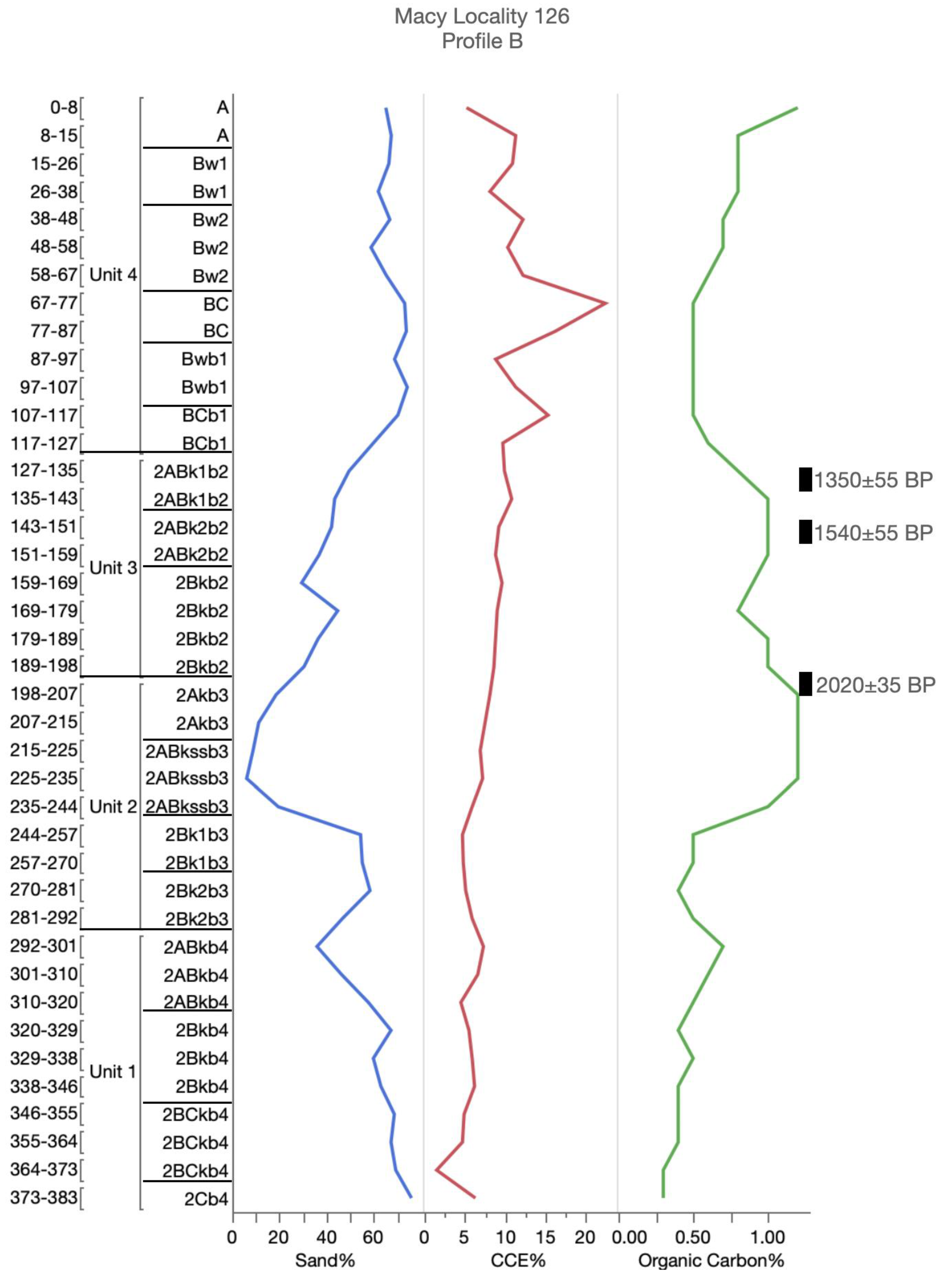
3.1.3. Late-Holocene Soils
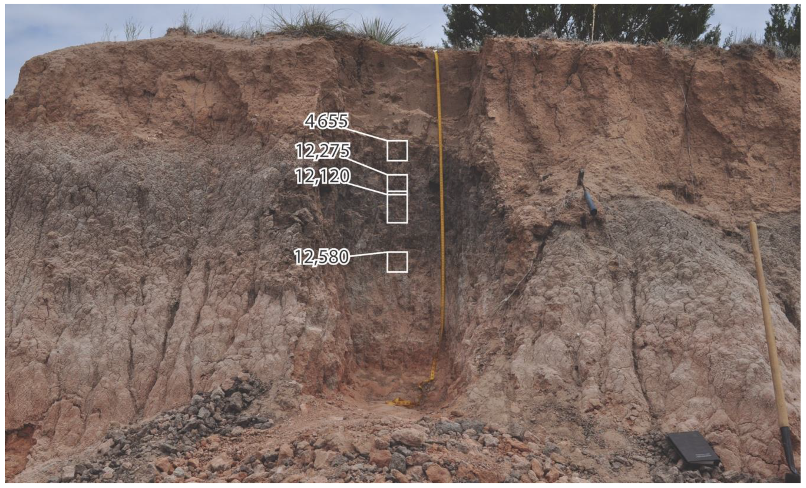
3.2. Radiocarbon Dating
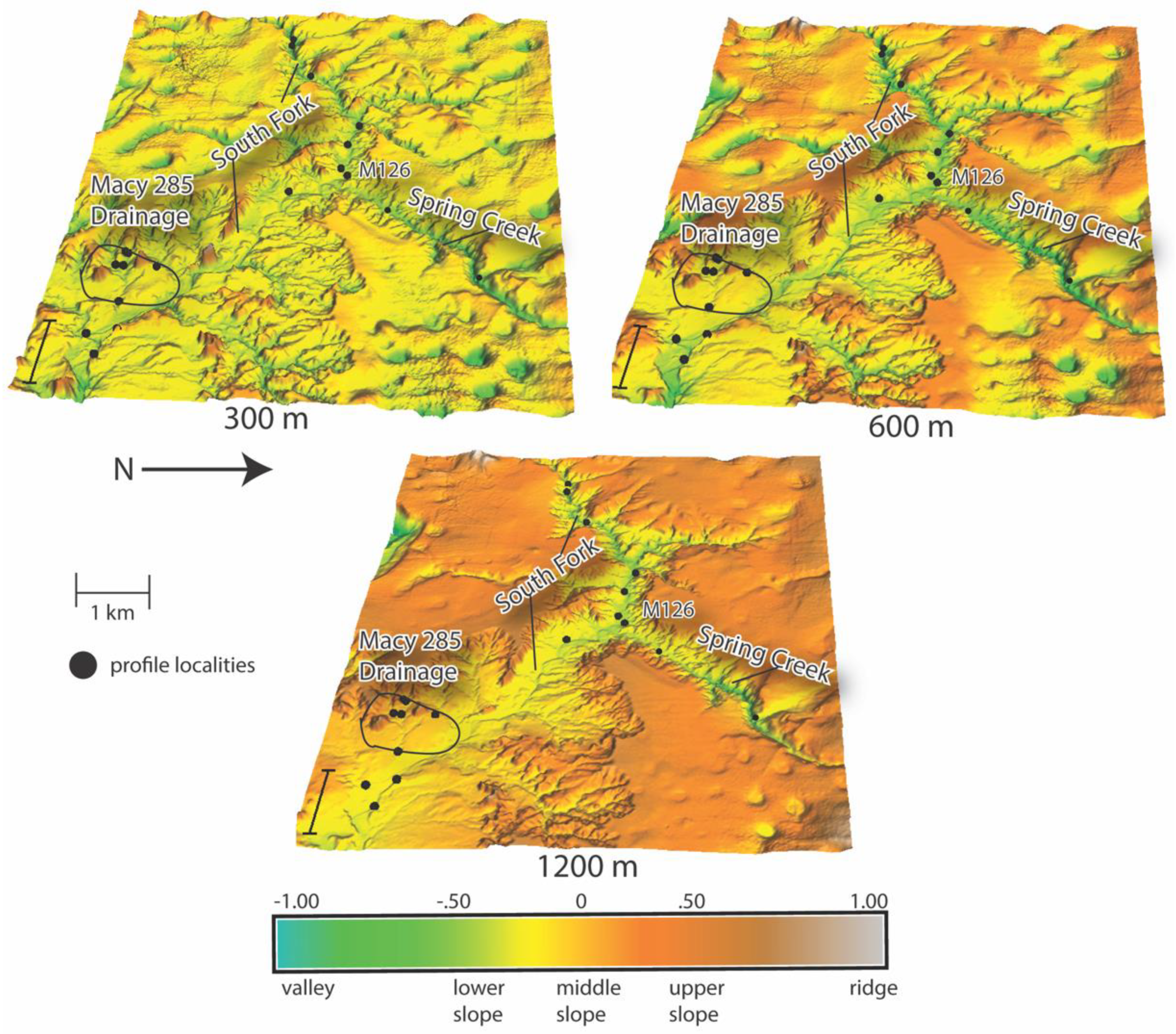
3.3. Topographic Position Analysis
4. Discussion
5. Conclusions
Author Contributions
Funding
Acknowledgments
Conflicts of Interest
Appendix A


References
- Dietrich, W.E.; Wilson, C.J.; Montgomery, D.R.; McKean, J.; Bauer, R. Erosion Thresholds and Land Surface Morphology. Geology 1992, 20, 675–679. [Google Scholar] [CrossRef]
- McNamara, J.P.; Ziegler, A.D.; Wood, S.H. Channel Head Locations with Respect to Geomorphologic Thresholds Derived from a Digital Elevation Model: A Case Study in Northern Thailand. For. Ecol. Manag. 2006, 224, 147–156. [Google Scholar] [CrossRef]
- Phillips, J.D. Thresholds, Mode Switching, and Emergent Equilibrium in Geomorphic Systems. Earth Surf. Process. Landf. 2014, 39, 71–79. [Google Scholar] [CrossRef]
- Maugnard, A.; Dyck, S.V.; Bielders, C. Assessing the Regional and Temporal Variability of the Topographic Threshold for Ephemeral Gully Initiation using Quantile Regression in Wallonia (Belgium). Geomorphology 2014, 206, 165–177. [Google Scholar] [CrossRef]
- Dietrich, W.E.; Wilson, C.J.; Montgomery, D.R.; McKean, J. Analysis of Erosion Thresholds, Channel Networks, and Landscape Morphology using a Digital Terrain Model. J. Geol. 1993, 101, 259–278. [Google Scholar] [CrossRef]
- Bryan, R.B. Soil Erodibility and Processes of Water Erosion on Hillslope. Geomorphology 2000, 32, 385–415. [Google Scholar] [CrossRef]
- Prosser, I.P.; Abernethy, B. Predicting the Topographic Limits to a Gully Network Using a Digital Terrain Model and Process Thresholds. Water Resour. Res. 1996, 32, 2289–2298. [Google Scholar] [CrossRef]
- Samani, A.; Ahmadi, H.; Jafari, M.; Boggs, G. Geomorphic Threshold Conditions for Gully Erosion in Southwestern Iran (Boushehr-Samal Watershed). J. Asian Earth Sci. 2009, 35, 180–189. [Google Scholar] [CrossRef]
- Svoray, T.; Michailov, E.; Cohen, A.; Rokah, L.; Sturm, A. Predicting Gully Initiation: Comparing Data Mining Techniques, Analytical Hierarchy Processes and the Topographic Threshold. Earth Surf. Process. Landf. 2012, 37, 607–619. [Google Scholar] [CrossRef]
- Fox, D.M.; Bryan, R.B. The Relationship of Soil Loss by Interrill Erosion to Slope Gradient. Catena 2000, 38, 211–222. [Google Scholar] [CrossRef]
- Knapen, A.; Poesen, J. Soil Erosion Resistance Effects on Rill and Gully Initiation Points and Dimensions. Earth Surf. Process. Landf. J. Br. Geomorphol. Res. Group 2010, 35, 217–228. [Google Scholar] [CrossRef]
- Poesen, J.; Torri, D.; Vanwalleghem, T. Gully Erosion: Procedures to Adopt when Modelling Soil Erosion in Landscapes Affected by Gullying. Handb. Eros. Model. 2011, 360–386. [Google Scholar] [CrossRef]
- Buol, S.W.; Hole, F.D.; McCracken, R.J.; Southard, R.J. Soil Genesis and Classification, 4th ed.; Iowa State University Press: Ames, IA, USA, 1997. [Google Scholar]
- Holliday, V.T. Soils in Archaeological Research; Oxford University Press: Oxford, UK, 2004. [Google Scholar]
- Arauza, H.M.; Simms, A.R.; Bement, L.C.; Carter, B.J.; Conley, T.O.; Woldergauy, A.; Johnson, W.C.; Jaiswal, P. Geomorphic and Sedimentary Responses of the Bull Creek Valley (Southern High Plains, USA) to Pleistocene and Holocene Environmental Change. Quat. Res. 2016, 85, 118–132. [Google Scholar] [CrossRef]
- Mandel, R.D. Buried Paleoindian-age Landscapes in Stream Valleys of the Central Plains, USA. Geomorphology 2008, 101, 342–361. [Google Scholar] [CrossRef]
- Schumm, S.A. Geomorphic Thresholds: The Concept and its Applications. Trans. Inst. Br. Geogr. 1979, 4, 485–515. [Google Scholar] [CrossRef]
- Muhs, D.R. Intrinsic Thresholds in Soil Systems. Phys. Geogr. 1984, 5, 99–110. [Google Scholar] [CrossRef]
- Jenny, H. Factors of Soil Formation; McGraw-Hill: New York, NY, USA, 1941. [Google Scholar]
- Birkeland, P.W. Soils and Geomorphology, 3rd ed.; Oxford University Press: New York, NY, USA, 1999. [Google Scholar]
- Butler, B.E. A New System for Soil Studies. J. Soil Sci. 1982, 33, 581–595. [Google Scholar] [CrossRef]
- Murphy, L.; Hurst, S.; Holliday, V.; Johnson, E. Late Quaternary Landscape Evolution, Soil Stratigraphy, and Geoarchaeology of the Caprock Canyonlands, Northwest Texas, USA. Quat. Int. 2014, 342, 57–72. [Google Scholar] [CrossRef]
- Sabin, T.J.; Holliday, V.T. Playas and Lunettes on the Southern High Plains: Morphometric and Spatial Relationships. Ann. Assoc. Am. Geogr. 1995, 85, 286–305. [Google Scholar] [CrossRef]
- Lehman, T.; Chatterjee, S. Depositional Setting and Vertebrate Biostratigraphy of the Triassic Dockum Group of Texas. J. Earth Syst. Sci. 2005, 114, 325–351. [Google Scholar] [CrossRef]
- Gustavson, T.C.; Baumgardner, R.W., Jr.; Caran, S.C.; Holliday, V.T.; Mehnert, H.H.; O’Neill, J.M. Quaternary Geology of the Southern Great Plains and an Adjacent Segment of the Rolling Plains. In Quaternary Nonglacial Geology: Conterminous U.S. Centennial Volume K-2; Geological Society of America: Boulder, CO, USA, 1991; pp. 477–501. [Google Scholar]
- Gustavson, T.C.; Winkler, D.A. Depositional Facies of the Miocene-Pliocene Ogallala Formation, Northwestern Texas and Eastern New Mexico. Geology 1988, 16, 203–206. [Google Scholar] [CrossRef]
- Ferring, C.R. Archaeological Geology of the Southern Plains. In Archaeological Geology of North America; Lasca, N.P., Donahue, J., Eds.; Geological Society of America: Boulder, CO, USA, 1990; pp. 253–266. [Google Scholar]
- Bomar, G.W. Texas Weather; University of Texas Press: Austin, TX, USA, 1995. [Google Scholar]
- Harragan, D. Blue Northers to Sea Breezes: Texas Weather and Climate; Hendrick Long Publishing Co.: Dallas, TX, USA, 1983. [Google Scholar]
- Brune, G. Springs of Texas; Branch-Smith: Fort Worth, TX, USA, 1981.
- Soil Survey Staff. Soil Survey Laboratory Information Manual. Soil Survey Investigations (Report 45); U.S. Department of Agriculture, Natural Resources Conservation Service, National Soil Survey Center: Lincoln, NE, USA, 1995.
- Soil Survey Staff. Soil Taxonomy (Agricultural Handbook 436); U.S. Department of Agriculture, Natural Resources Conservation Service: Washington, DC, USA, 1999.
- Soil Survey Staff. Kellogg Soil Survey Laboratory Methods Manual (Soil Survey Investigations Report 42); U.S. Department of Agriculture, Natural Resources Conservation Service, National Soil Survey Center: Lincoln, NE, USA, 2014.
- Clark, C.W.; Hudnall, W.H. Field Method for Determining Carbonate. In Proceedings of the 2006 Soil Science Society of America Conference, Indianapolis, IN, USA, 12–16 November 2006. [Google Scholar]
- Holliday, V.T. Stratigraphy and Paleoenvironments of Late Quaternary Valley Fills on the Southern High Plains (Memoir 186); Geological Society of America: Boulder, CO, USA, 1995. [Google Scholar]
- Johnson, E.; Holliday, V.T.; Martínez, G.; Gutiérrez, M.; Politis, G. Geochronology and Landscape Development along the Middle Río Quequén Grande at the Paso Otero Locality, Pampa Interserrana, Argentina. Geoarchaeology 2012, 27, 300–323. [Google Scholar] [CrossRef]
- Hammond, A.; Goh, K.; Tonkin, P.; Manning, M.R. Chemical Pretreatments for Improving the Radiocarbon Dates of Peats and Organic Silts in a Gley Podzol Environment: Grahams Terrace, North Westland. N. Z. J. Geol. Phys. 1991, 34, 191–194. [Google Scholar] [CrossRef]
- Head, M.; Zhou, W.; Zhou, M. Evaluation of 14C Ages of Organic Fractions of Paleosols from Loess-Paleosol Sequences Near Xian, China. Radiocarbon 1989, 31, 680–695. [Google Scholar] [CrossRef]
- Wang, Y.; Amundson, R.; Trumbore, S. Radiocarbon Dating of Soil Oganic Matter. Quat. Res. 1996, 45, 282–288. [Google Scholar] [CrossRef]
- De Reu, J.; Bourgeois, J.; Bats, M.; Zwertvaegher, A.; Gelorini, V.; De Smedt, P.; Chu, W.; Antrop, M.; De Maeyer, P.; Finke, P. Application of the Topographic Position Index to Heterogeneous Landscapes. Geomorphology 2013, 186, 39–49. [Google Scholar] [CrossRef]
- De Reu, J.; Bourgeois, J.; De Smedt, P.; Zwertvaegher, A.; Antrop, M.; Bats, M.; De Maeyer, P.; Finke, P.; Van Meirvenne, M.; Verniers, J. Measuring the relative topographic position of archaeological sites in the landscape, a case study on the Bronze Age barrows in northwest Belgium. J. Archaeol. Sci. 2011, 38, 3435–3446. [Google Scholar] [CrossRef]
- Weiss, A. Topographic Position and Landforms Analysis. In Proceedings of the 2001 ESRI User Conference, San Diego, CA, USA, 9–13 July 2001. [Google Scholar]
- Conley, T.O. Paleo-Environmental Landscape Evolution on the Eastern Caprock Escarpment of the Southern High Plains, Texas. Ph.D. Thesis, Department of Geosciences, Texas Tech University, Lubbock, TX, USA, 2016. [Google Scholar]
- Blum, M.D.; Abbott, J.T.; Valastro, S., Jr. Evolution of Landscapes on the Double Mountain Fork of the Brazos River, West Texas: Implications for Preservation and Visibility of the Archaeological Record. Geoarchaeology 1992, 7, 339–370. [Google Scholar] [CrossRef]
- Church, M. Geomorphic Thresholds in Riverine Landscapes. Freshw. Biol. 2002, 47, 541–557. [Google Scholar] [CrossRef]
- Ehlers, K.B.; Moe, J.R.; Johnson, E.; Hurst, S. Trade on the Llano Estacado: A Protohistoric Site (41GR793) at the Base of the Southern High Plains, Texas. In Proceedings of the 69th Plains Anthropological Conference, Tucson, AZ, USA, 26–29 October 2011. [Google Scholar]
- Hurst, S.; Ward, D.C.; Johnson, E.; Cunningham, D. Cowboy Life along the Llano Estacado Eastern Escarpment of Northwest Texas: Insights from Macy Locality 16 (41GR722). Hist. Archaeol. 2018, 52, 332–347. [Google Scholar] [CrossRef]
- Moretti, J.; Johnson, E. The First Record of the Jumping Mouse Zapus from the Southern High Plains. PaleoAmerica 2015, 1, 121–123. [Google Scholar] [CrossRef]
- Moretti, J.A. The Vertebrate Fauna of Macy Locality 100: Exploring Late Pleistocene Community Composition in Non-Analog North America. Master’s Thesis, Interdisciplinary Studies, Texas Tech University, Lubbock, TX, USA, 2018. [Google Scholar]
- Hurst, S.; Johnson, E.; Cunningham, D. Macy Locality-15, a Late-Paleoindian Site along the Caprock Escarpment of Texas. Curr. Res. Pleistocene 2008, 25, 68–69. [Google Scholar]
- Hall, S.A. Channel Trenching and Climatic Change in the Southern US Great Plains. Geology 1990, 18, 342–345. [Google Scholar] [CrossRef]
- Cama, M.; Schillaci, C.; Kropácek, J.; Hochschild, V.; Bosino, A.; Märker, M. A Probabilistic Assessment of Soil Erosion Susceptibility in a Head Catchment of the Jemma Basin, Ethiopian Highlands. Geosciences 2020, 10, 248. [Google Scholar] [CrossRef]
- Hancock, G.R.; Evans, K.G. Gully Position, Characteristics and Geomorphic Thresholds in an Undisturbed Catchment in Northern Australia. Hydrol. Process. 2006, 20, 2935–2951. [Google Scholar] [CrossRef]
- Kariminejad, N.; Rossi, M.; Hosseinalizadeph, M.; Pourghasemi, H.R.; Santosh, M. Gully Head Modelling in Iranian Loess Plateau Under Different Scenarios. Catena 2020, 194, 1047693. [Google Scholar] [CrossRef]


| Locality | Soil Horizon | Depth (cm) | Material Assayed 1 | 14C Age (yrs. B.P.) 2 | δ13C | cal yr B.P. 2 | Dating Type | Lab No. |
|---|---|---|---|---|---|---|---|---|
| Macy Locality 45 Profile A | ||||||||
| CPMACY45A-01 | 2Ab3 + ky | 130–140 | SOM (r) | 840 ± 65 | −17.6 | 911-835 | Conventional | A15779 |
| SOM (h) | 1135 ± 95 | −17.9 | 1282-844 | Conventional | A15779.1 | |||
| CPMACY45A-02 | 2ABb3 + ky | 145–155 | SOM (r) | 1200 ± 65 | −17.6 | 1270-980 | Conventional | A15780 |
| SOM (h) | 1645 ± 105 | −17.4 | 1812-1343 | Conventional | A15780.1 | |||
| CPMACY45A-03 | 2ABb3 + ky | 165–177 | SOM (r) | 1505 ± 70 | −16.7 | 1537-1297 | Conventional | A15781 |
| SOM (h) | 1665 ± 115 | −17.0 | 1860-1827 | Conventional | A15781.1 | |||
| Macy Locality 45 Profile B | ||||||||
| CPMACY45B-01 | Ab1 | 63–76 | SOM (r) | 765 ± 80 | −17.9 | 850-832 | Conventional | A15782 |
| SOM (h) | 730 ± 110/105 | −18.4 | 906-831 | Conventional | A15782.1 | |||
| CPMACY45B-02 | ABb1 | 76–90 | SOM (r) | 1070 ± 80 | −17.6 | 1180-796 | Conventional | A15783 |
| SOM (h) | 975 ± 115 | −18.7 | 1173-1159 | Conventional | A15783.1 | |||
| CPMACY45B-03 | ABb1 | 90–106 | SOM (r) | 605 ± 75 | −18.4 | 676-515 | Conventional | A15784 |
| SOM (h) | 800 ± 110 | −19.1 | 932-624 | Conventional | A15784.1 | |||
| Macy Locality 46 Profile A | ||||||||
| CPMACY46A-01 | 2ABtkb | 41–58 | SOM (r) | 920 ± 50 | −15.5 | 928-736 | Conventional | A15785 |
| SOM (h) | 625 ± 135/130 | −17.2 | 902-865 | Conventional | A15785.1 | |||
| Macy Locality 126 Profile B | ||||||||
| CPMACY126B-01 | 2ABk1b2 | 127–137 | SOM (r) | 1240 ± 70/65 | −17.5 | 1293-1050 | Conventional | A15801 |
| SOM (h) | 1350 ± 55 | −18.5 | 1367-1176 | AMS | A15801.1 | |||
| CPMACY126B-02 | 2ABk2b2 | 143–153 | SOM (r) | 1540 ± 55 | −16.6 | 1546-1328 | Conventional | A15802 |
| SOM (h) | 1500 ± 35 | −18.7 | 1520-1458 | AMS | A15802.1 | |||
| CPMACY126B-03 | 2AKb3 | 198–208 | SOM (r) | 1970 ± 55 | −15.8 | 2108-2082 | Conventional | A15803 |
| SOM (h) | 2020 ± 35 | −18.7 | 2102-2089 | AMS | A15803.1 | |||
| CPMACY126B-04 | 2ABkb4 | 292–302 | SOM (r) | 2685 ± 105/100 | −19.2 | 3067-2676 | Conventional | A15804 |
| SOM (h) | Insufficient Sample | A15804.1 | ||||||
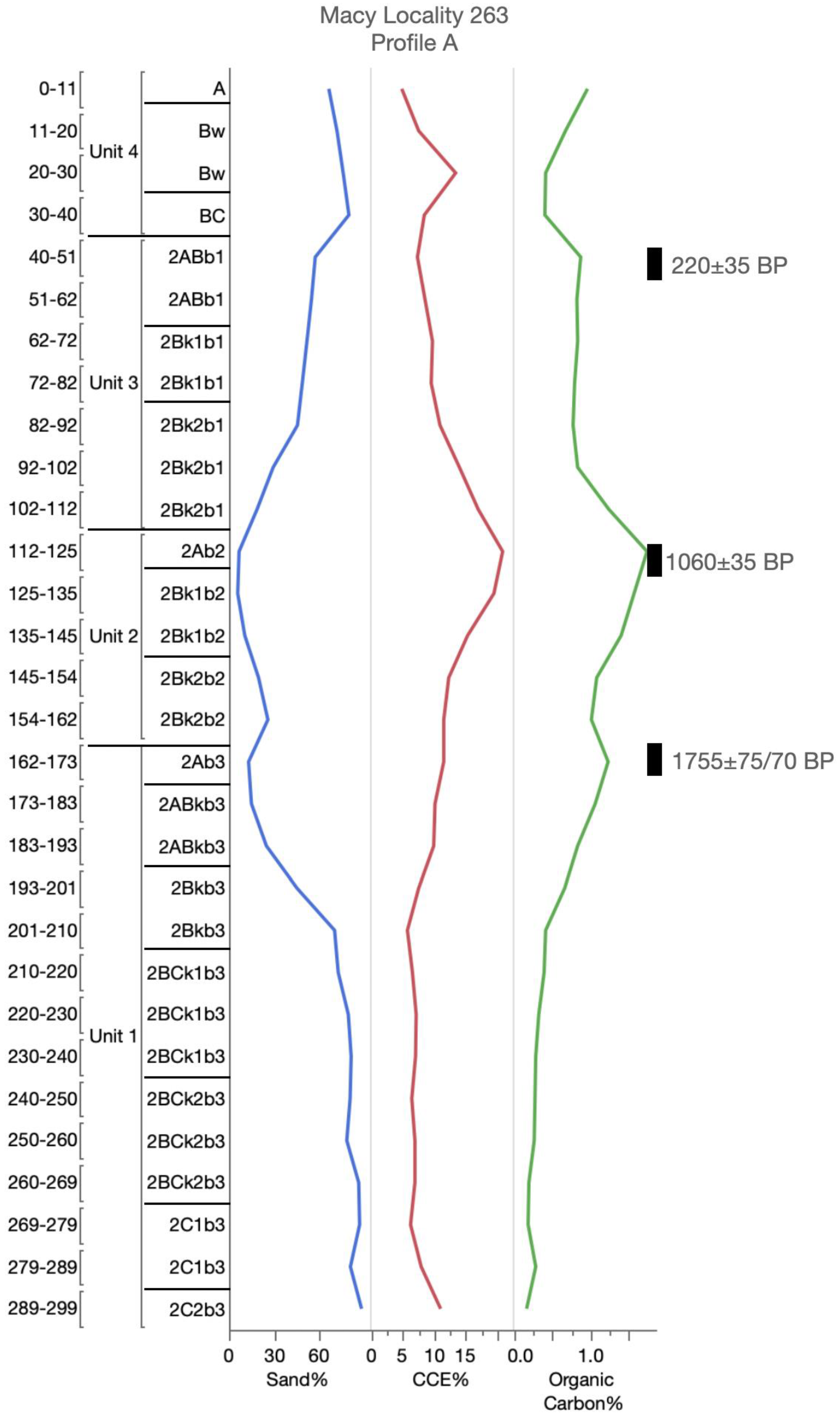
| Macy Locality 263 Profile A | ||||||||
| CPMACY263A-01 | 2ABb1 | 40–50 | SOM (r) | Post-Bomb, 101.5 ± −0.9 pMC | −17.2 | Conventional | A15805 | |
| SOM (h) | 220 ± 35 | −16.6 | 421-410 | AMS | 15805.1 | |||
| CPMACY263A-02 | 2Ab2 | 112–125 | SOM (r) | 930 ± 45 | −15.0 | 929-744 | Conventional | A15806 |
| SOM (h) | 1060 ± 35 | −16.4 | 1056-1021 | AMS | A15806.1 | |||
| CPMACY263A-03 | 2Ab3 | 162–173 | SOM (r) | 1755 ± 75/70 | −17.6 | 1863-1844 | Conventional | A15807 |
| SOM (h) | 1740 ± 35 | −17.7 | 1728-1557 | AMS | A15807.1 | |||
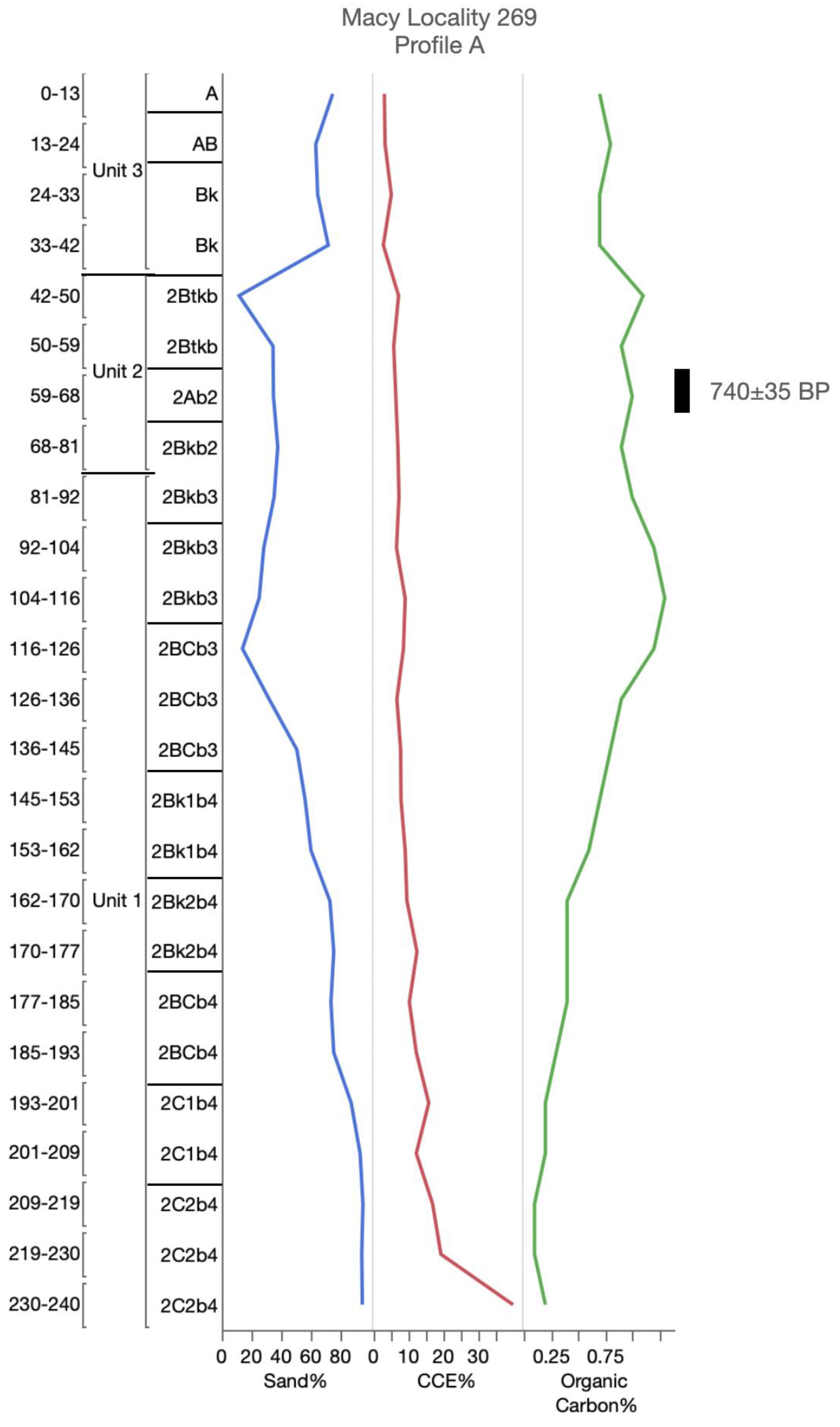
| Macy Locality 269 Profile A | ||||||||
| CPMACY269A-01 | 2Ab2 | 59–68 | SOM (r) | 720 ± 45 | −15.0 | 733-635 | Conventional | A15808 |
| SOM (h) | 740 ± 35 | −15.3 | 732-654 | AMS | A15808.1 | |||
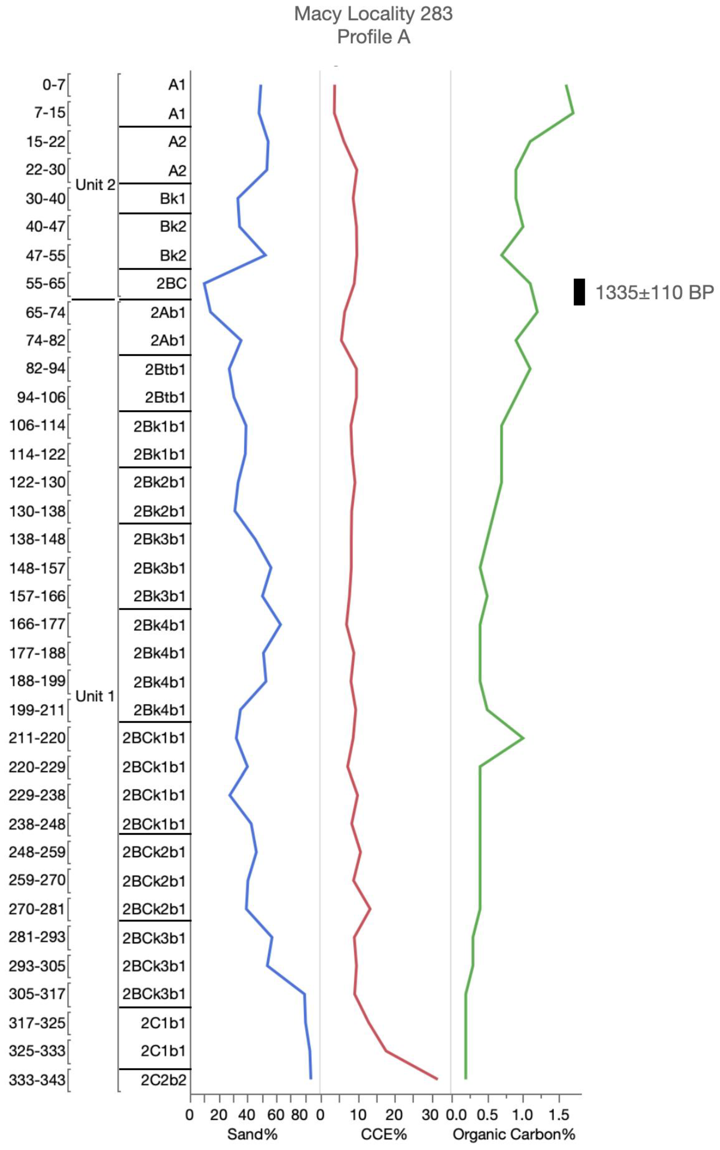
| Macy Locality 283, Profile A | ||||||||
| CPMACY283A-02 | SOM (h) | 1335 ± 110 | −15.6 | 1518-1490 | Conventional | A15814.1 | ||
| 2Ab1 | 74–82 | SOM (r) | 970 ± 55 | −15.2 | 971-760 | Conventional | A15815 | |
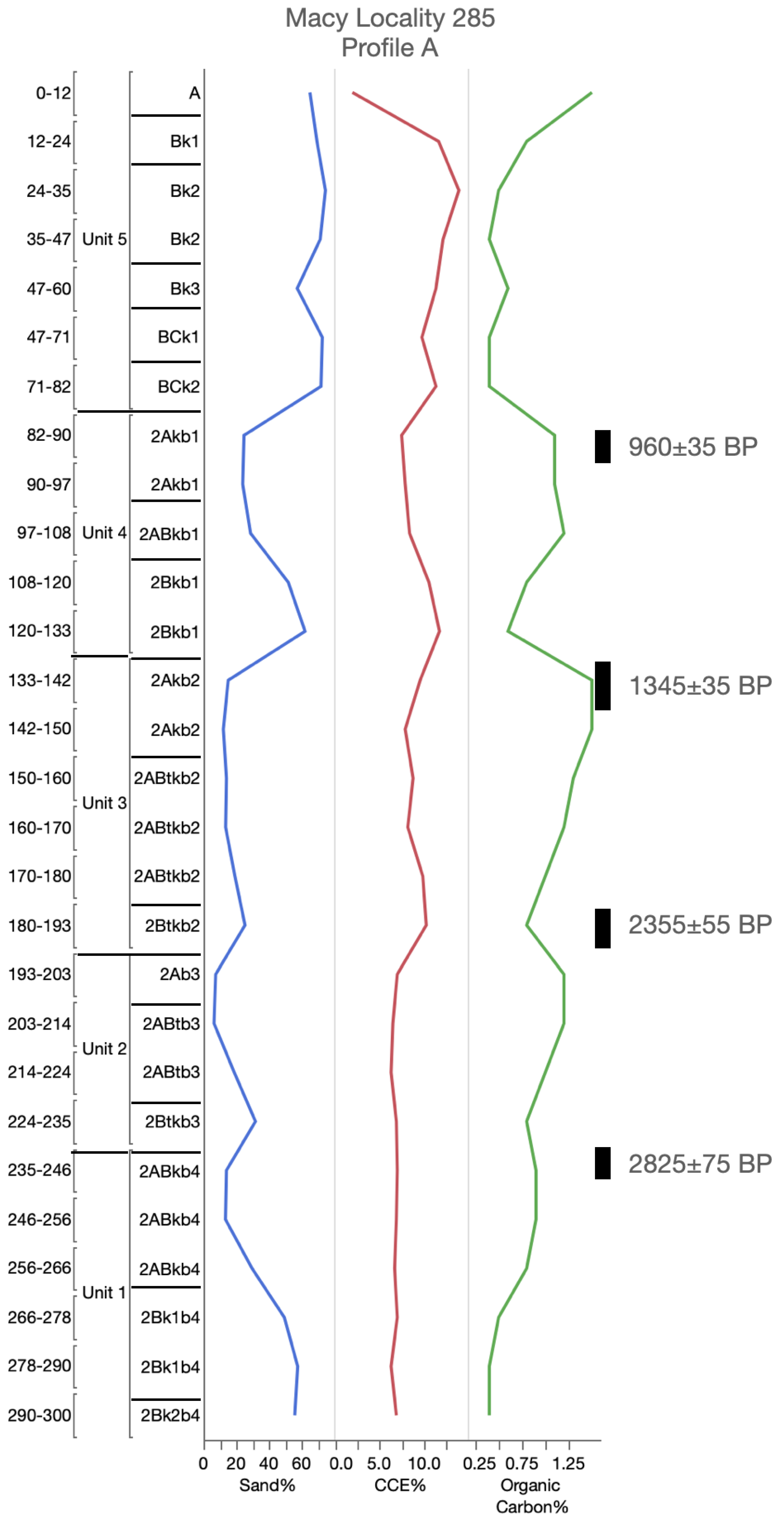
| Macy Locality 285 Profile A | SOM (h) | 1225 ± 130 | −15.8 | 1390-911 | Conventional | A15815.1 | ||
| CPMACY285A-01 | ||||||||
| 2Akb1 | 82–92 | SOM (r) | 870 ± 45 | −16.8 | 910-841 | Conventional | A15816 | |
| CPMACY285A-02 | SOM (h) | 960 ± 35 | −21.0 | 933-792 | AMS | A15816.1 | ||
| 2Akb2 | 133–143 | SOM (r) | 1260 ± 35 | −16.3 | 1283-1160 | Conventional | A15817 | |
| CPMACY285A-03 | SOM (h) | 1345 ± 35 | −18.5 | 1315-1227 | AMS | A15817.1 | ||
| 2Ab3 | 193–203 | SOM (r) | 2355 ± 55 | −16.6 | 2699-2632 | Conventional | A15818 | |
| CPMACY285A-04 | SOM (h) | 2255 ± 40 | −17.3 | 2348-2292 | AMS | A15818.1 | ||
| 2ABkb4 | 235–245 | SOM (r) | 2825 ± 75 | −16.5 | 3156-3089 | Conventional | A15819 | |
| Macy Locality 286 Profile A | SOM (h) | 2715 ± 40 | −18.1 | 2918-2912 | AMS | A15819.1 | ||
| CPMACY286A-01 | ||||||||
| Akb1 | 33–50 | SOM (r) | 545 ± 45 | −16.5 | 647-585 | Conventional | A15820 | |
| CPMACY286A-02 | SOM (h) | 640 ± 105/100 | −14.6 | 785-499 | Conventional | A15820.1 | ||
| 2Akb2 | 82–95 | SOM (r) | 1105 ± 45 | −15.7 | 1237-1206 | Conventional | A15821 | |
| CPMACY286A-03 | SOM (h) | 1305 ± 105/100 | −16.6 | 1395-980 | Conventional | A15821.1 | ||
| 2Akb2 | 95–108 | SOM (r) | 1295 ± 50 | −16.3 | 1302-1172 | Conventional | A15822 | |
| CPMACY286A-04 | SOM (h) | 1580 ± 105 | −17.0 | 1705-1299 | Conventional | A15822.1 | ||
| 2Akb2 | 108–121 | SOM (r) | 1455 ± 65 | −16.2 | 1523-1452 | Conventional | A15823 | |
| Macy Locality 286 Profile B | SOM (h) | 1660 ± 105 | −16.8 | 1817-1353 | Conventional | A15823.1 | ||
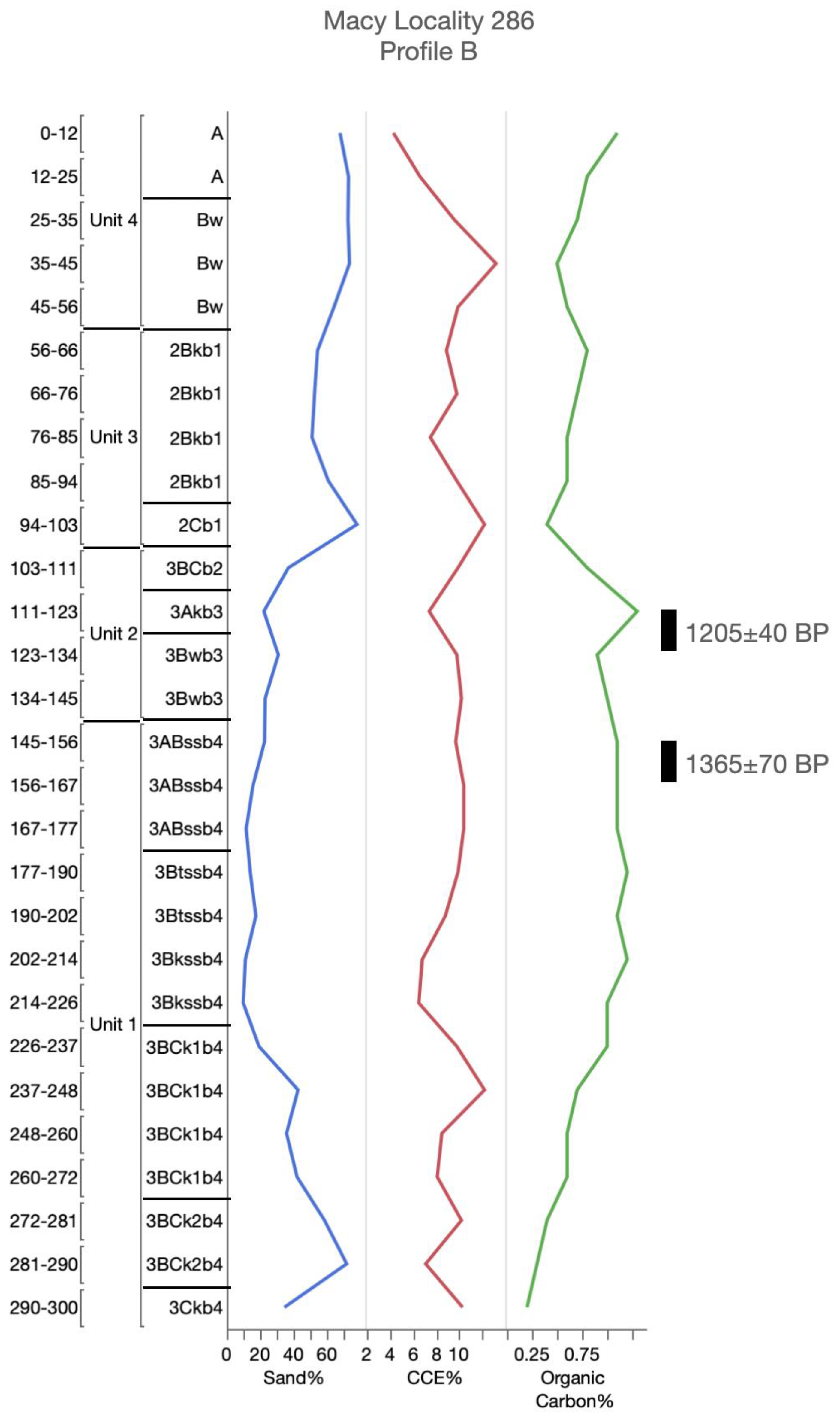
| CPMACY286B-01 | ||||||||
| 3Akb3 | 111–123 | SOM (r) | 1125 ± 55 | −16.1 | 1176-936 | Conventional | A15824 | |
| CPMACY286B-02 | SOM (h) | 1205 ± 40 | −17.3 | 1262-1052 | AMS | A15824.1 | ||
| 3ABssb4 | 145–155 | SOM (r) | 1365 ± 70 | −16.0 | 1409-1172 | Conventional | A15825 | |
| Macy Locality 287 Profile A | SOM (h) | 1195 ± 140/135 | −17.0 | 1363-896 | Conventional | A15825.1 | ||
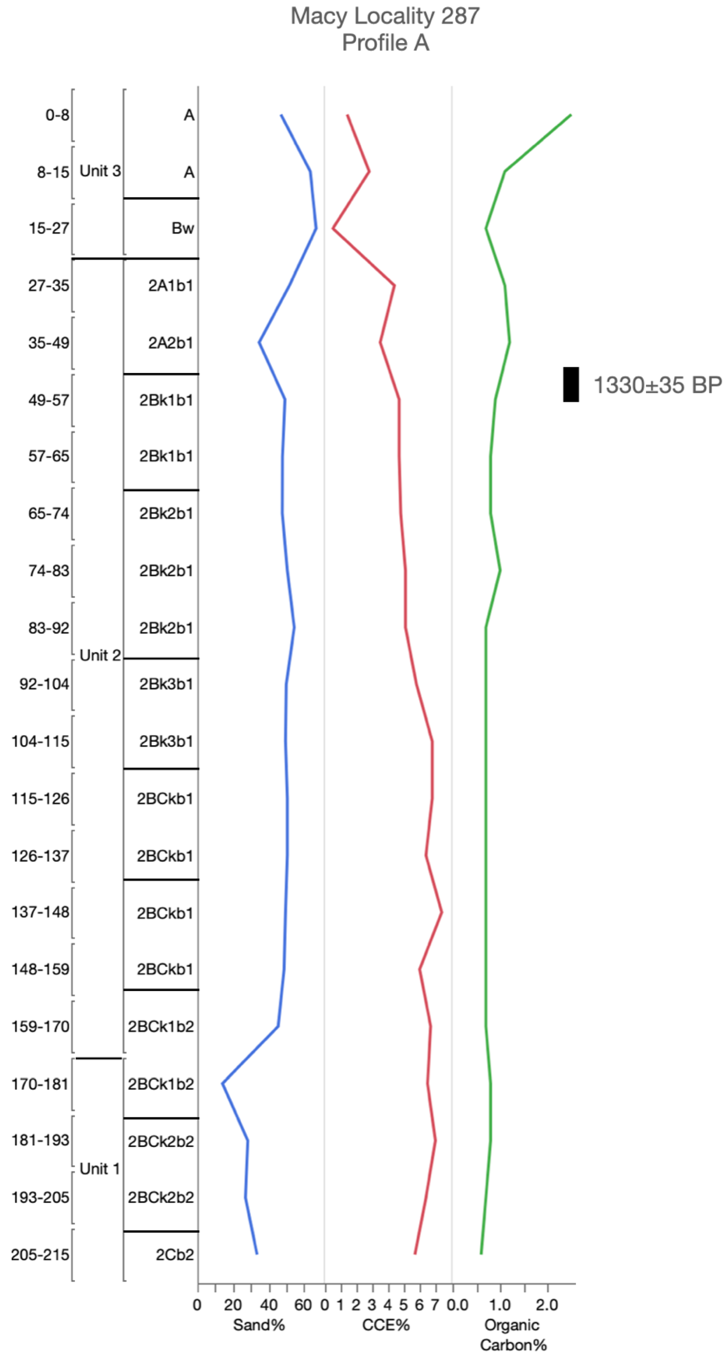
| CPMACY287A-01 | ||||||||
| 2A2b1 | 35–49 | SOM (r) | 815 ± 60 | −17.0 | 906-853 | Conventional | A15826 | |
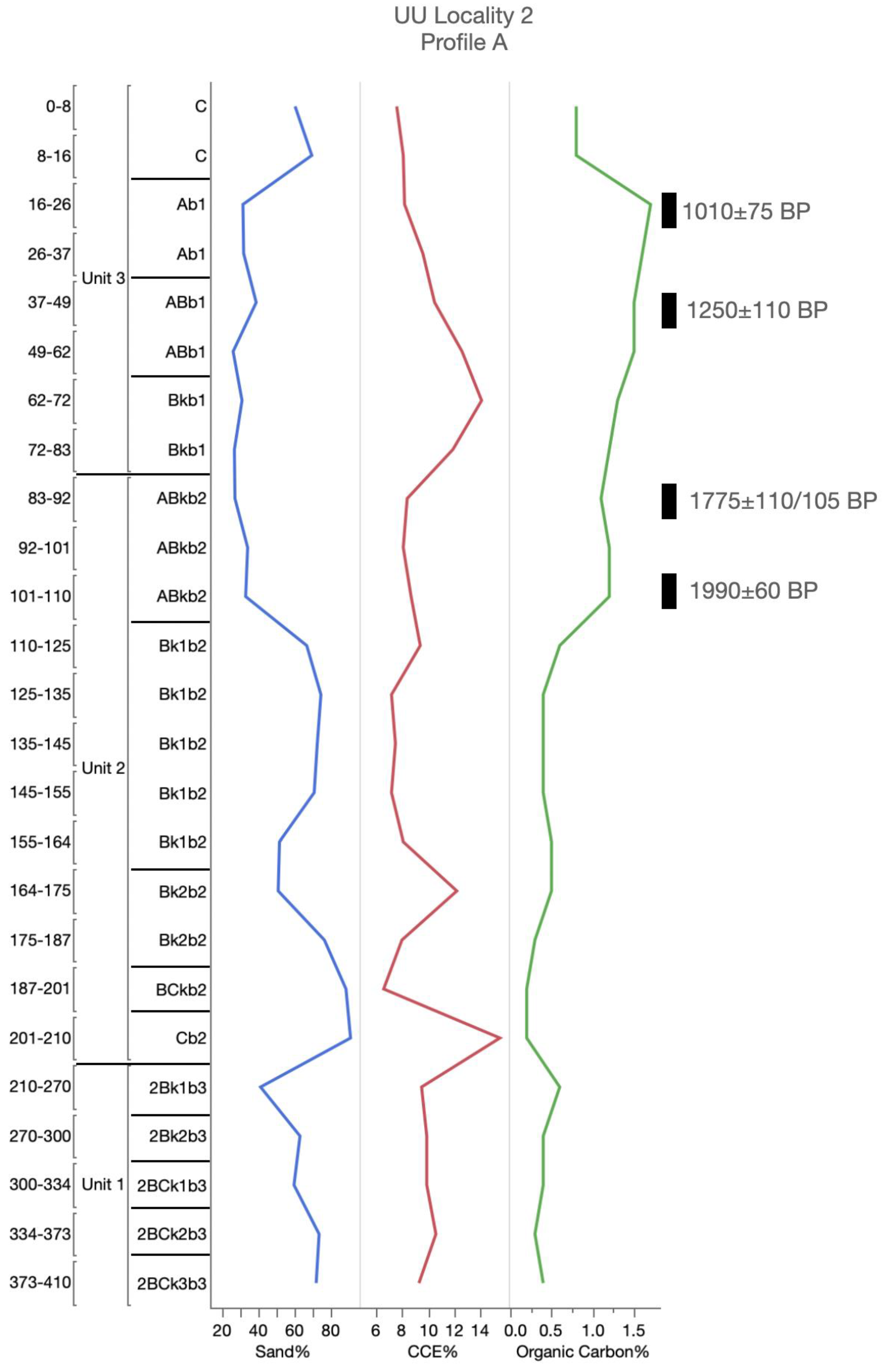
| U.U. Locality 2 Profile A | SOM (h) | 1330 ± 35 | −19.0 | 1305-1225 | AMS | A15826.1 | ||
| CPUU2A-01 | ||||||||
| Ab1 | 16–26 | SOM (r) | 800 ± 50 | −16.6 | 895-874 | Conventional | A16085 | |
| CPUU2A-02 | SOM (h) | 1010 ± 75 | −16.0 | 1071-738 | Conventional | A16085.1 | ||
| ABb1 | 37–47 | SOM (r) | 1195 ± 65 | −16.3 | 1269-976 | Conventional | A16086 | |
| CPUU2A-03 | SOM (h) | 1250 ± 110 | −17.3 | 1347-954 | Conventional | A16086.1 | ||
| ABkb2 | 83–93 | SOM (r) | 1605 ± 65 | −17.5 | 1690-1671 | Conventional | A16087 | |
| CPUU2A-04 | SOM (h) | 1775 ± 110/105 | −17.7 | 1945-1476 | Conventional | A16087.1 | ||
| ABkb2 | 100–110 | SOM (r) | 1990 ± 60 | −16.3 | 2114-1821 | Conventional | A16088 | |
| CPUU3A-01 | SOM (h) | 1845 ± 25 | −16.7 | 1864-1842 | AMS | A16088.1 | ||
| 2ABkb2 | 84–94 | SOM (r) | 9290 ± 215/205 | −17.0 | 1186-10,119 | Conventional | A16089 | |
| CPUU3A-02 | SOM (h) | 5705 ± 25 | −18.8 | 6560-6411 | AMS | A16089.1 | ||
| 2ABkb3 | 130–140 | SOM (r) | 11,580 ± 140/135 | −16.6 | 13,719-13,148 | Conventional | A16090 | |
| CPUU3A-03 | SOM (h) | Insufficient Sample | A16090.1 | |||||
| 2ABkb3 | 150–159 | SOM (r) | 11,375 ± 170 | −15.5 | 13,559-12,870 | Conventional | A16091 | |
| U.U. Locality 4 Profile A | SOM (h) | Insufficient Sample | A16091.1 | |||||
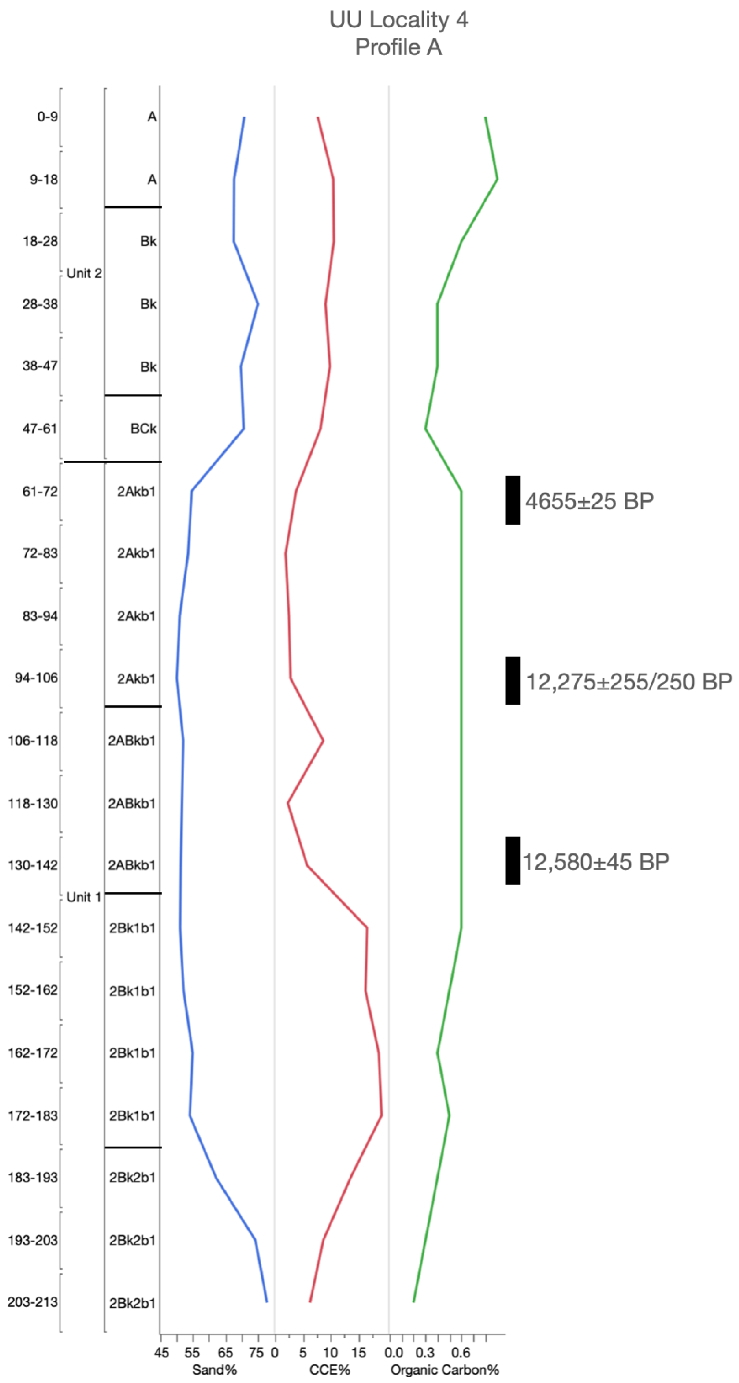
| CPUU4A-01 | ||||||||
| 2Akb1 | 61–72 | SOM (r) | 4520 ± 120 | −16.5 | 5569-5559 | Conventional | A16096 | |
| CPUU4A-02 | SOM (h) | 4655 ± 25 | −16.6 | 5466-5346 | AMS | A16096.1 | ||
| 2Akb1 | 94–106 | SOM (r) | 10,480 ± 200/195 | −16.2 | 12,745-11,696 | Conventional | A16097 | |
| CPUU4A-03 | SOM (h) | 12,275 ± 255/250 | −16.3 | 15,195-13,606 | Conventional | A16097.1 | ||
| 2ABkb1 | 106–118 | SOM (r) | 10,270 ± 210/205 | −16.1 | 12,600-11,310 | Conventional | A16098 | |
| CPUU4A-04 | SOM (h) | 12,120 ± 290/280 | −16.5 | 15,128-13,439 | Conventional | A16098.1 | ||
| 2ABkb1 | 130–142 | SOM (r) | 11,335 ± 285/275 | −17.3 | 13,752-12,707 | Conventional | A16099 | |
| U.U. Locality 5 Profile A | SOM (h) | 12,580 ± 45 | −17.3 | 15,154-14,667 | AMS | A16099.1 | ||
| CPUU5A-01 | ||||||||
| 2ABkb1 | 29–39 | SOM (r) | 600 ± 70 | −14.8 | 671-519 | Conventional | A16100 | |
| CPUU5A-02 | SOM (h) | 900 ± 170/165 | −15.9 | 1180-620 | Conventional | A16100.1 | ||
| 2Akb2 | 63–74 | SOM (r) | 1465 ± 90 | −15.1 | 1556-1240 | Conventional | A16101 | |
| CPUU5A-03 | SOM (h) | 1600 ± 145/140 | −15.8 | 1864-1841 | Conventional | A16101.1 | ||
| 2Akb2 | 74–86 | SOM (r) | 1890 ± 80 | −15.6 | 2001-1617 | Conventional | A16102 | |
| CUU5-01 | SOM (h) | 2015 ± 30 | −16.0 | 2044-1889 | Conventional | A16102.1 | ||
| CPUU5A-04 | 2Bk2b2 | 85,144.9 | Charcoal | 2210 ± 40 | −22.9 | 2331-2133 | AMS | A16079 |
| U.U. Locality 6 Profile A | 2Bk2b2 | 131 | Charcoal | 2340 ± 45 | −21.7 | AMS | A16080 | |
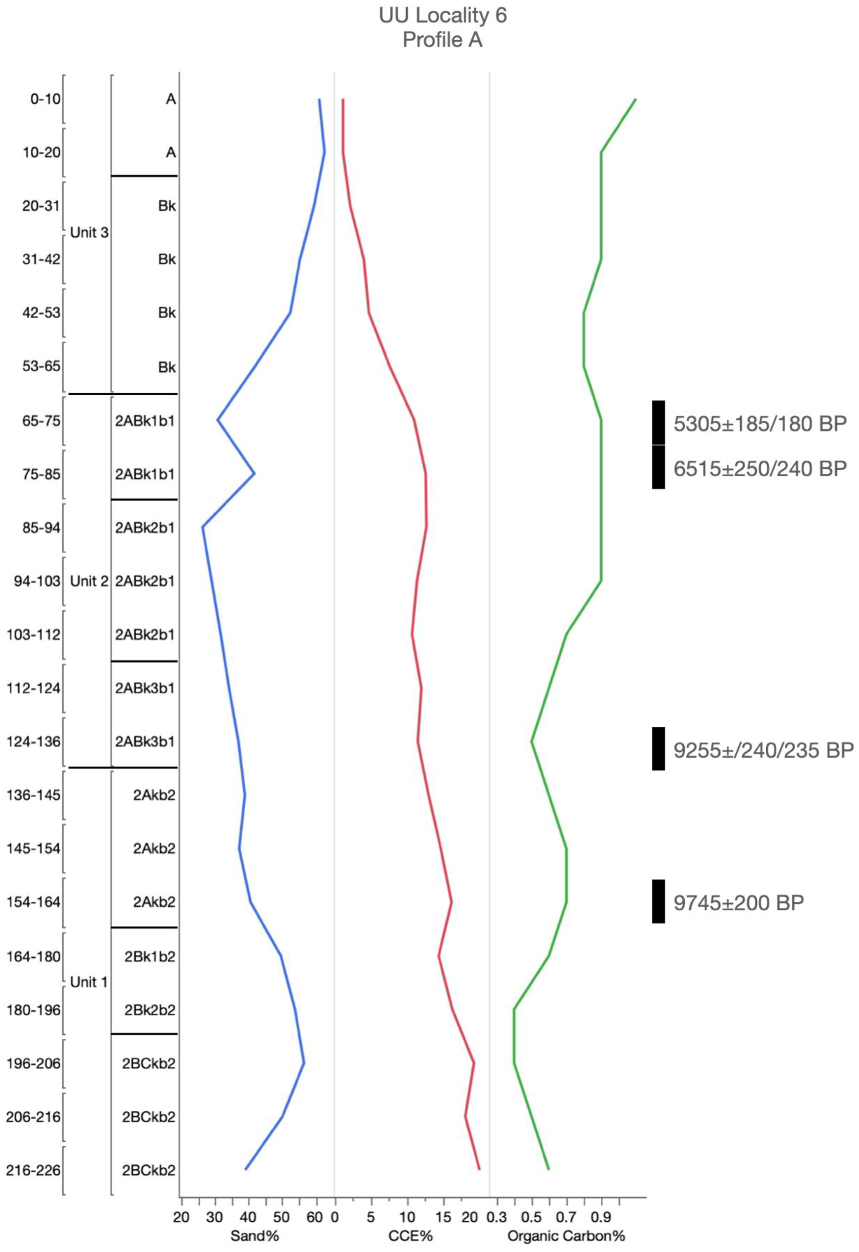
| CPUU6A-01 | ||||||||
| 2ABk1b1 | 65–75 | SOM (r) | 3095 ± 100 | −16.7 | 3557-3531 | Conventional | A16103 | |
| CPUU6A-02 | SOM (h) | 5305 ± 185/180 | −17.5 | 6447-5658 | Conventional | A16103.1 | ||
| 2ABk1b1 | 75–85 | SOM (r) | 4115 ± 100 | −16.8 | 4865-4406 | Conventional | A16104 | |
| CPUU6A-03 | SOM (h) | 6515 ± 250/240 | −17.6 | 7927-7896 | Conventional | A16104.1 | ||
| 2ABk3b1 | 124–136 | SOM (r) | 8155 ± 230/220 | −17.0 | 9547-8516 | Conventional | A16105 | |
| CPUU6A-04 | SOM (h) | 9255 ± 240/235 | −17.1 | 11,195-9886 | Conventional | A16105.1 | ||
| 2Akb2 | 136–146 | SOM (r) | 9100 ± 205/200 | −17.5 | 11,046-11,040 | Conventional | A16106 | |
| CPUU6A-05 | SOM (h) | 8770 ± 250/240 | −16.7 | 10,509-9283 | Conventional | A16106.1 | ||
| 2Akb2 | 154–164 | SOM (r) | 9745 ± 200 | −16.2 | 11,933-11,889 | Conventional | A16107 | |
| SOM (h) | 9500 ± 260/250 | −15.8 | 11,700-11,671 | Conventional | A16107.1 |
Publisher’s Note: MDPI stays neutral with regard to jurisdictional claims in published maps and institutional affiliations. |
© 2020 by the authors. Licensee MDPI, Basel, Switzerland. This article is an open access article distributed under the terms and conditions of the Creative Commons Attribution (CC BY) license (http://creativecommons.org/licenses/by/4.0/).
Share and Cite
Conley, T.; Hurst, S.; Johnson, E. Topographic Thresholds and Soil Preservation along the Southern High Plains Eastern Escarpment, Northwest Texas, USA. Geosciences 2020, 10, 476. https://doi.org/10.3390/geosciences10120476
Conley T, Hurst S, Johnson E. Topographic Thresholds and Soil Preservation along the Southern High Plains Eastern Escarpment, Northwest Texas, USA. Geosciences. 2020; 10(12):476. https://doi.org/10.3390/geosciences10120476
Chicago/Turabian StyleConley, Travis, Stance Hurst, and Eileen Johnson. 2020. "Topographic Thresholds and Soil Preservation along the Southern High Plains Eastern Escarpment, Northwest Texas, USA" Geosciences 10, no. 12: 476. https://doi.org/10.3390/geosciences10120476
APA StyleConley, T., Hurst, S., & Johnson, E. (2020). Topographic Thresholds and Soil Preservation along the Southern High Plains Eastern Escarpment, Northwest Texas, USA. Geosciences, 10(12), 476. https://doi.org/10.3390/geosciences10120476