1. Introduction
Rockfall is the most frequent natural event in mountainous areas. Rockfalls are classified as a type of landslide that consists of the detachment of a rock block (or several individual rocks) from a vertical or sub-vertical cliff followed by rapid down-slope motion characterized by free-falling, bouncing, rolling, and sliding phases [
1,
2]. Cruden [
3] and Zabota [
4] complement this definition by stating that a rockfall is a fragmented rock or block that has detached from a surface slope or cliff by falling, sliding, toppling, bouncing, or rolling. Rockfall, commonly, is a relatively small limited sliding to the removal of individual and surface rocks from a cliff [
5,
6]. Rockfall can generate massive large-scale movements of solid material, but these processes are defined as rockfall or rock avalanches [
3,
7,
8]. A common approach to explaining rockfall is to analyze the environmental conditions that promote the occurrence of rocks and those factors that initiate movement [
9,
10]. Detachment mechanisms include natural climatic conditions, such as freeze-thaw [
11], lithology, morphology [
12], slope gradient [
13], faults, and seismic activities [
14,
15].
Compared to other types of landslides, the proportion of rockfall research is small [
2,
16]. However, driven by the demand for civil works construction in mountainous areas, rockfall research is increasingly attracting the attention of academics and researchers [
17,
18]. Rockfall not only threatens the environment but also generates a severe loss of life within its area of influence because it behaves suddenly, frequently, and randomly [
19,
20,
21]. Every year, blocks ranging from a few kilograms to tens of tons cause traffic interruptions, damage to structures and vehicles, and sometimes fatalities [
22]. These natural disasters have been a subject of intensive research due to their significant destructive power: (i) Gotthard Tunnel in Switzerland: on 31 May 2006, a major rockfall (5000 m
3) killed two tourists on the main highway crossing the Alps through the Gotthard Tunnel [
23], and (ii) ski resort Whistler, Vancouver, Canada: during the night of 29 July 2008, a rockfall blocked the highway Sea to Sky joining Vancouver to the ski resort Whistler [
24].
Protecting people and infrastructure against rockfall phenomena is one of the most challenging tasks [
25,
26,
27]. For this purpose, risk assessment procedures play a crucial role [
20,
28,
29,
30,
31]. Therefore, rockfall-related studies are of great importance to prevent and reduce risk and to improve disaster mitigation and preparedness capabilities. During the past four decades, numerous studies have elucidated the various perspectives of rockfall hazards. In the scientific literature for evaluating hazard and risk from falling rocks, various qualitative and quantitative approaches have been proposed (e.g., References [
32,
33,
34,
35,
36,
37]). The choice between qualitative and quantitative hazard methodology is strictly related to the available dataset and does not depend on the complexity of the methods that are used to define the hazard [
38]. Due to qualitative methods are based on the qualitative classification of the attributes of the rock surface, quantitative approaches require a significant amount of site-specific data [
39,
40].
For the protection and prevention of risks that a rockfall can cause are the construction of specialized structures or the maintenance and creation of green areas, for example, by building capture or barrier fences and containment networks [
41], but these measures are expensive and deteriorate over time [
42]. In some cases, maintaining forest stands with an explicit protection function, or a protection forest is profitable and more sustainable [
43,
44]. Therefore, studies related to rockfalls are of great importance to prevent and reduce risk and to improve disaster mitigation and preparedness capabilities.
The monitoring and early warning of rockfall hazards in mountainous areas are also necessary. Commonly used technologies of rockfall monitoring include light detection and ranging (LiDAR), laser scanning, geographical information systems (GISs), and video image recognition [
45,
46]. In addition, researchers usually combine LiDAR, laser scanning, and GIS technology to establish a three-dimensional numerical model of a rockfall and to analyze the spatiotemporal characteristics of rockfall hazards [
47,
48,
49].
Over the past four decades, some researchers have submitted revisions and diverse perspectives of the risks of rockfalls in geo-environmental and geosciences science. Dorren [
9] summarized existing rockfall models and proposed modifications to make them suitable for predicting rockfall on a regional scale; Volkwein et al. [
50] and Ferrari et al. [
39] provided an overview of both rockfall modeling, as well as hazard zoning and protective measures. These investigations have provided valuable information within the topic; therefore, it is necessary to carry out a systematic review, as well as bibliometric analysis for the integration of all the studies carried out.
The corresponding research results have been published by authors from all over the world in a large number of journals. To summarize global rockfall research trends and provide a potential guide for future research, a bibliometric analysis was applied to rockfall-related articles from Scopus databases during the period 1975–2019. This will allow us to integrate knowledge, understanding the evolution and trends in a field of research. On this, we pose the following question: Is it possible to evaluate the evolution and trends related to research on the Rockfall theme through bibliometric analysis that allows a better understanding of the topic and that serves as a guide for future research?
Given these antecedents and what is stated in the research question, the scientific work aimed to review the intellectual structure of Rockfall, through analysis of scientific production using bibliometric techniques that allow its analysis, knowledge, its global evolution, and future trend lines about Rockfall. In this research work, three sections are presented: (i) Literary review on the subject and explanation of the methodology used, (ii) presentation of quantitative and qualitative results on the scientific production on Rockfall, and (iii) bibliometric analysis of the results, their discussion, conclusion and presentation of future research trends.
2. Materials and Methods
The literature review is an essential contribution to research progress by providing a systematic procedure that seeks to minimize potential biases and errors when selecting studies in a given area of knowledge, as well as an in-depth description of independent research efforts to identify potential gaps and highlight the limits of knowledge [
51,
52,
53]. In this regard, Rowley and Slack [
54] recommend a comprehensive methodology to structure a literature review, where bibliometric analyzes contemplate a similar systematic process [
55].
Bibliometric studies consider a scientific field that uses quantitative analysis to describe, evaluate, and monitor scientific publications in a field of science and identify its main trends [
56,
57,
58], allowing the analysis of the structure of a scientific research field [
59,
60]. This type of analysis was introduced in the academy by Eugene Garfield in the mid-20th century [
61], and today it has spread in various academic fields, such as management [
62], environment [
63], and Earth Sciences. This last field has allowed the study of some disciplines, such as seismology [
64], marine hazards [
65], hydrogeology [
66], landslides [
67,
68], remote sensing [
69], oil industry [
70], and geotourism [
71], among others. In bibliometric analysis, a topic called bibliometric mapping is presented, which allows a visual understanding of the structure and behavior of the scientific field by observing the connections in its structure represented by units of analysis, such as documents, countries, or authors [
72].
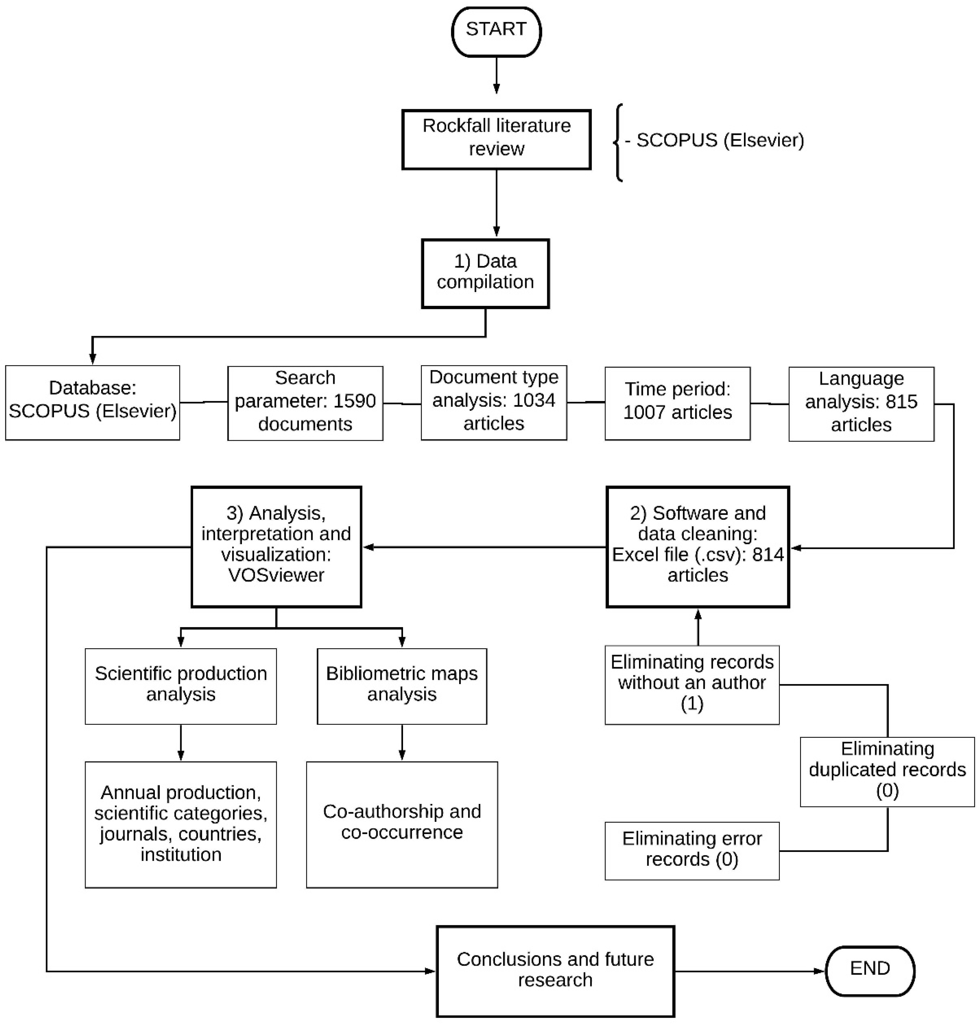
The proposed methodology for this bibliometric study is structured and comprises three phases: (1) Data compilation, (2) software and data cleaning, and (3) analysis, interpretation and visualization; to identify the most influential studies, in order to determine the thematic areas of research and provide information on current research interests. A summary of the application of the methodology shown in
Figure 1.
2.1. Data Compilation
In bibliometric studies, the first step is the selection of an adequate and reliable database that allows the analysis to be carried out [
73]. Currently, there is a debate on the comparability and stability of the statistical data obtained according to the two primary databases: Web of Science (WoS) and Scopus [
74]. For this analysis, we chose the Scopus scientific database, which belongs to Elsevier, for our bibliometric analysis [
75]. According to Elsevier, Scopus is the largest database of citations and summaries of peer-reviewed literature that has been used by various researchers for bibliometric analysis in various areas of research [
76,
77]. Scopus is a multidisciplinary database that has more than 69 million records; also, it has more indexed journals than the WoS [
78,
79].
The next step is the choice of the search parameter, which consists of a guide that avoids extensive results, which opens the door to literature that is not related to the area of knowledge and too limited results that leave out the scientific literature. important in the field [
56,
80,
81]. In this investigation, the documents were considered relevant, in which our search argument appears only in the title [
82,
83,
84]. The search argument is: (TITLE (“Rock-fall*”) OR TITLE (“Rockfall*”)), search carried out in April 2020, obtaining 1590 documents.
The study source was limited to the analysis of only published articles, which guarantees the academic quality of the publications and the homogenization of the results [
85]. Indexed journals ensure academic quality, which is backed by a blind peer review [
86]. With this search parameter, publications are obtained between 1942 and 2020; with the latter being this year, we exclude it because the totality of documents would not be available.
Finally, we considered an additional parameter related to language, in that only those written in English were analyzed because this language dominates scientific production in most scientific areas and is one of the most used restrictions in articles that use the bibliometric analysis [
87,
88]. With this last limitation, the final search argument was as follows: (TITLE (“Rock-fall*”) OR TITLE (“Rockfall*”)) AND (LIMIT-TO (DOCTYPE, “ar”)) AND (EXCLUDE (PUBYEAR, 2020)) AND (LIMIT-TO (LANGUAGE, “English”)).
2.2. Software and Data Cleaning
The obtained information was exported to an Excel spreadsheet for analysis and organization [
68,
89]. Our database had a variety of parameters, in which the following are highlighted: the author’s details (name/s and affiliation/s), the title of the article, the title of the journal, keywords used, the abstract, and the dating count. The reference collection needed to be reviewed and debugged by making the following adjustments: (i) delete records without an author, (ii) delete duplicate files, and (iii) delete error records. We reviewed the database, and only the first adjustment reported inconsistency in an article; therefore, our database was reduced to 814 scientific articles.
2.3. Analysis, Interpretation and Visualization
Among the most widely used, leading and educational free access software based on its excellent results and data processing, we have the VOSviewer [
90]. VOSviewer software is a tool popularly used in bibliometric literature and its analysis in different areas of knowledge [
62,
91,
92,
93]. This software was developed for the construction and visualization of bibliometric maps, which show the structure and networks of authors, magazines, universities, and countries [
94]. VOSviewer is used to build author or journal maps based on co-citation data or to make keyword maps based on co-occurrence data [
95,
96].
4. Discussion
This bibliometric analysis focused on determining the evolution and trend of the researches in terms of authors, citations, journals, and keywords.
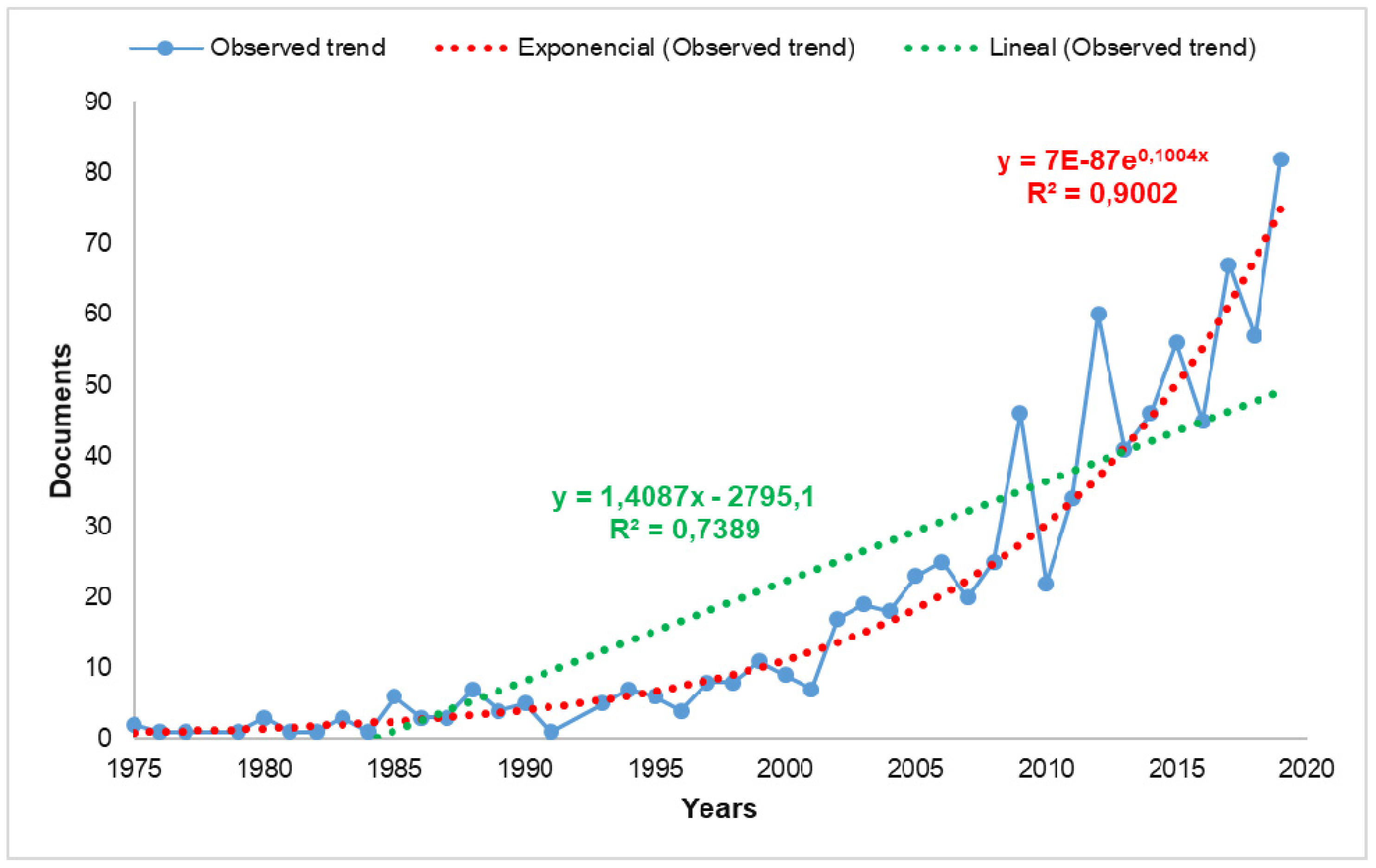
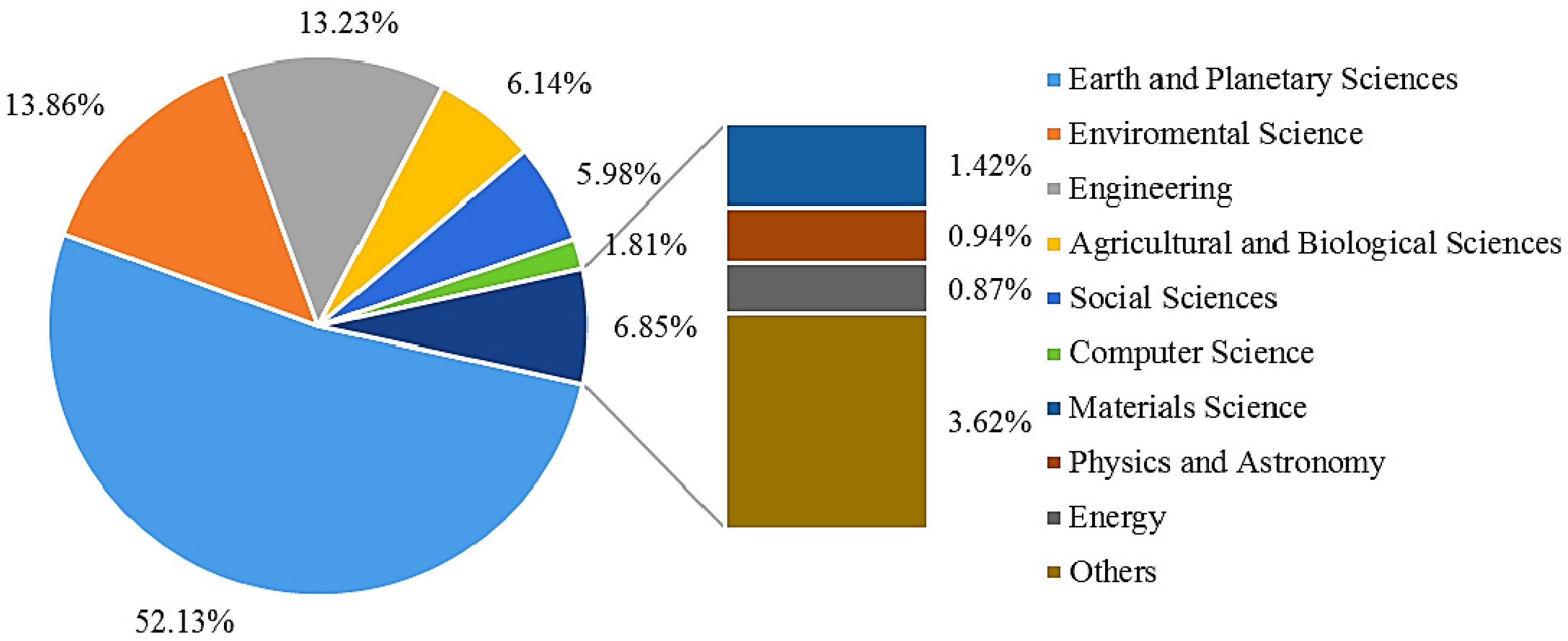
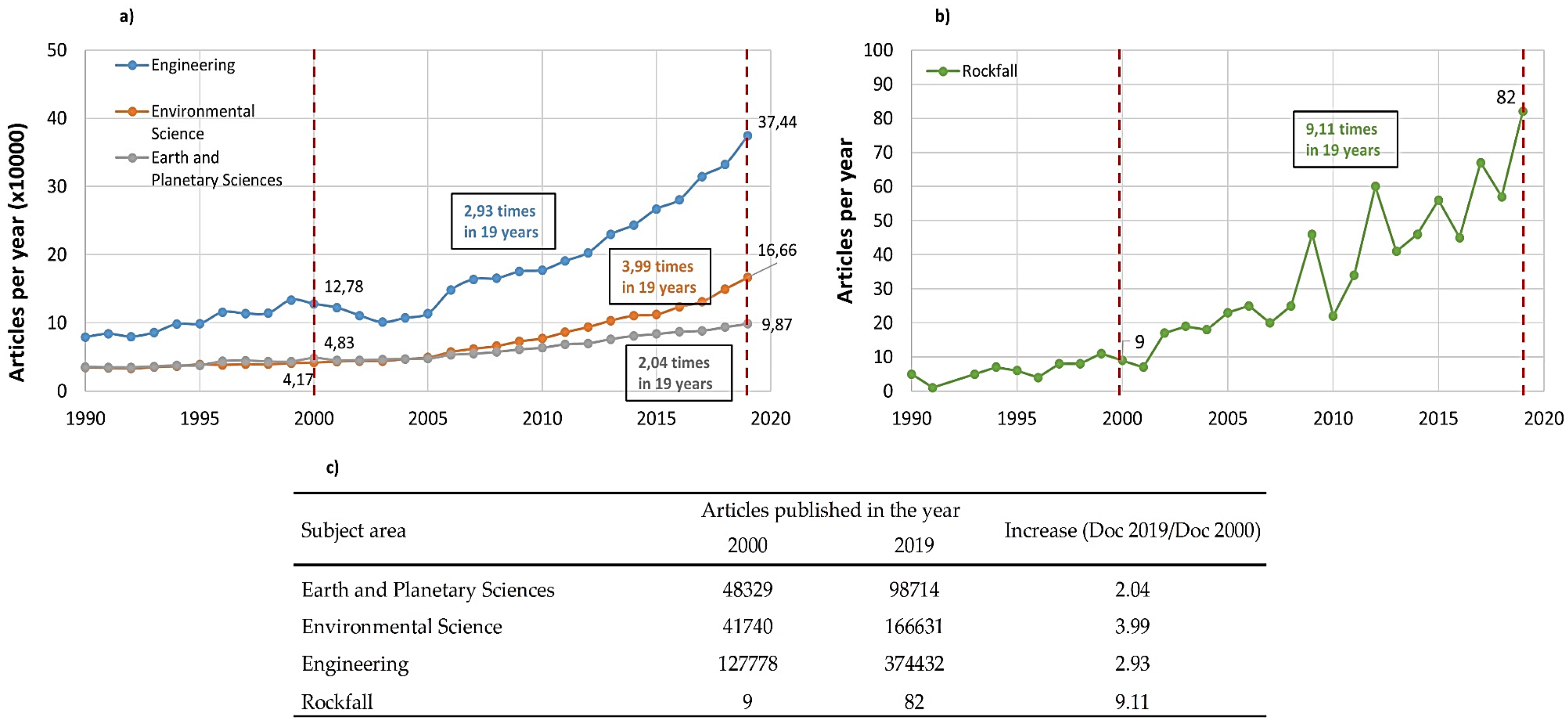
Figure 2 shows the number of scientific publications per year, in rockfall-related articles, since 1975. This increase in production can be compared with the global increase in scientific papers in the most productive and outstanding subject areas in
Figure 3. In
Figure 8, it proceeds to compare, from the years 2000 and 2019, the production of articles in English (such as the search argument carried out in rockfall topic) of the most prominent subject areas. Noting that, the increase in rockfall-related articles is more notable (increases 9.11 times) than the increases in Earth and Planetary Sciences (increases 2.04 times), Environmental Science (increases 3.99 times), and Engineering (increases 2.93 times).
This bibliometric analysis identifies the authors with the most significant number of publications: Stoffel, M. (27), Bourrier, F. (21), Jaboyedoff, M. (17), and Giacomini, A. (16). All of them analyze the theme of rockfall from different perspectives; Stoffel, M. focuses more on the interaction between rockfall and tree ring activity and using Dendromorphology. Bourrier, F. and Giacomini, A. analyze the trajectory of rockfalls using 3D simulators, the efficiency of protective barriers against rockfall and determine danger zones. Finally, Jaboyedoff, M. explains risk zones using different techniques, such as terrestrial laser scanner, kinetic energy, and GIS-based parameter rating.
The analysis shows that the journals with the highest number of articles on the subject are Natural Hazards and Earth System Sciences with 76 publications and Landslides with 54 publications; Geomorphology follows with 41 publications. In the case of Natural Hazards and Earth System Sciences and Landslides, contributions focused on rockfall susceptibility assessments using different scenarios. Finally, Geomorphology contributions aimed at modeling the mountain or slope for path prediction and rockfall hazard analysis.
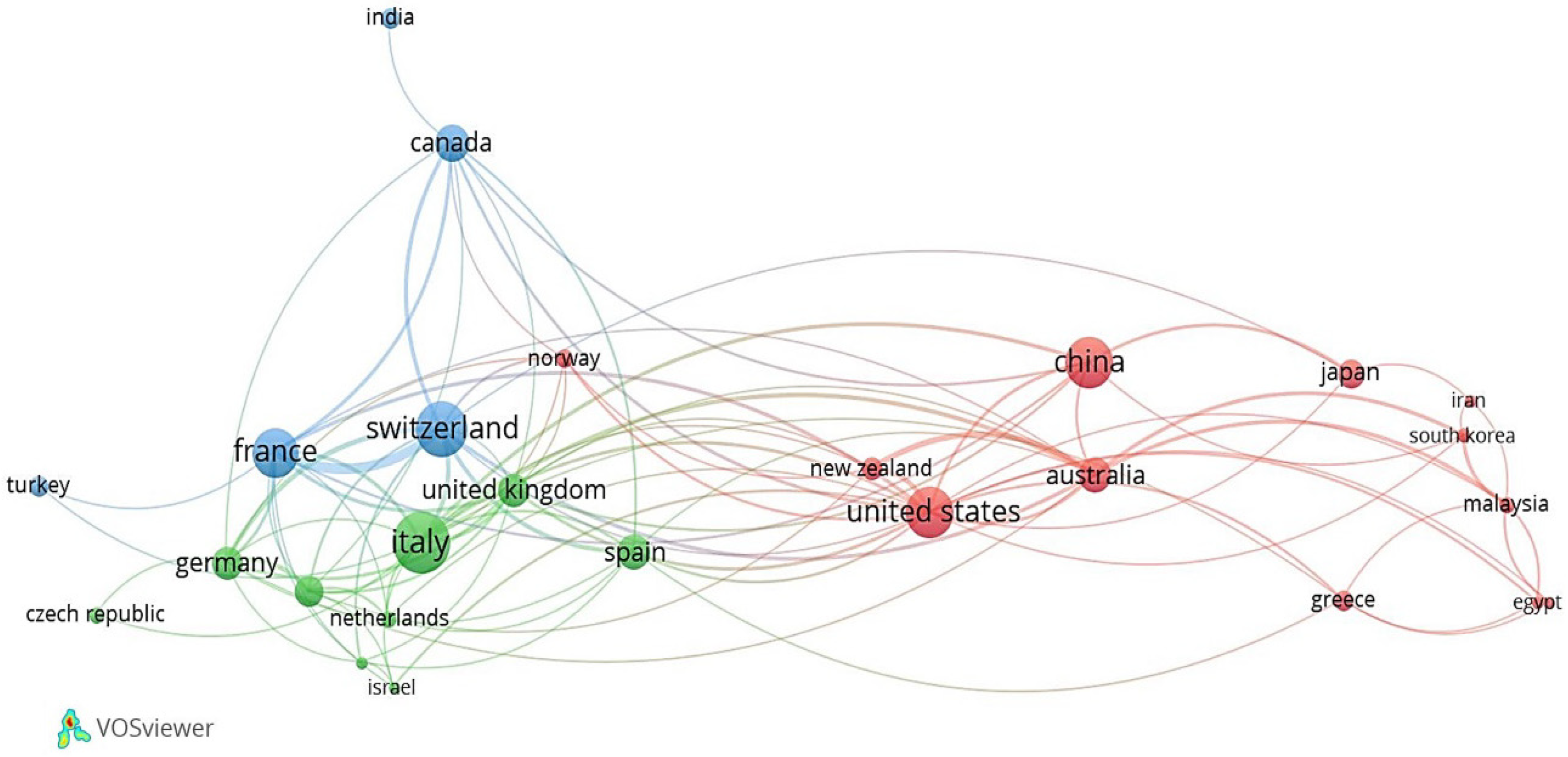
From the analysis of scientific production in the countries, it was determined that Europe and Asia are the continents with the most research countries on this subject, with 39 of 54 states and their main contributors belong to Europe (8), Asia (3), America (2), and Oceania (2) (
Table 3). It should be noted that the countries with the most significant number of publications have areas of mountain ranges on their territory, in some cases with high instability, for example, Italy, France and Switzerland share one of the best-known mountain ranges, the Alps. On the other hand, China, the United States, and Japan have mountainous areas in their territories, but these suffer as a consequence of earthquakes due to its proximity to the so-called Ring of Fire. These are reasons that we have considered to explain the interest in the subject by these countries.
The scientific productivity of institutional collaboration (
Table 4) shows that the greatest contribution corresponds to those of French nationality, unlike
Table 4, where Italy is the leader. The first institute in Italy is in seventh (Consiglio Nazionale delle Ricerche), which has a production of almost 30% less than the institution located first (Universite Grenoble Alpes). In contrast to
Table 4 with
Table 5, there are no institutions in the top ten of countries like Canada, Australia, and Spain (sixth, seventh, and eighth, respectively). So, it suggests a variety of institutions in which these publications are distributed. From
Table 4, it should also be highlighted that researchers report or register more than one affiliation (two or more institutions from the same country or another country); therefore, the institutions included in
Table 4 may match in one or more papers.
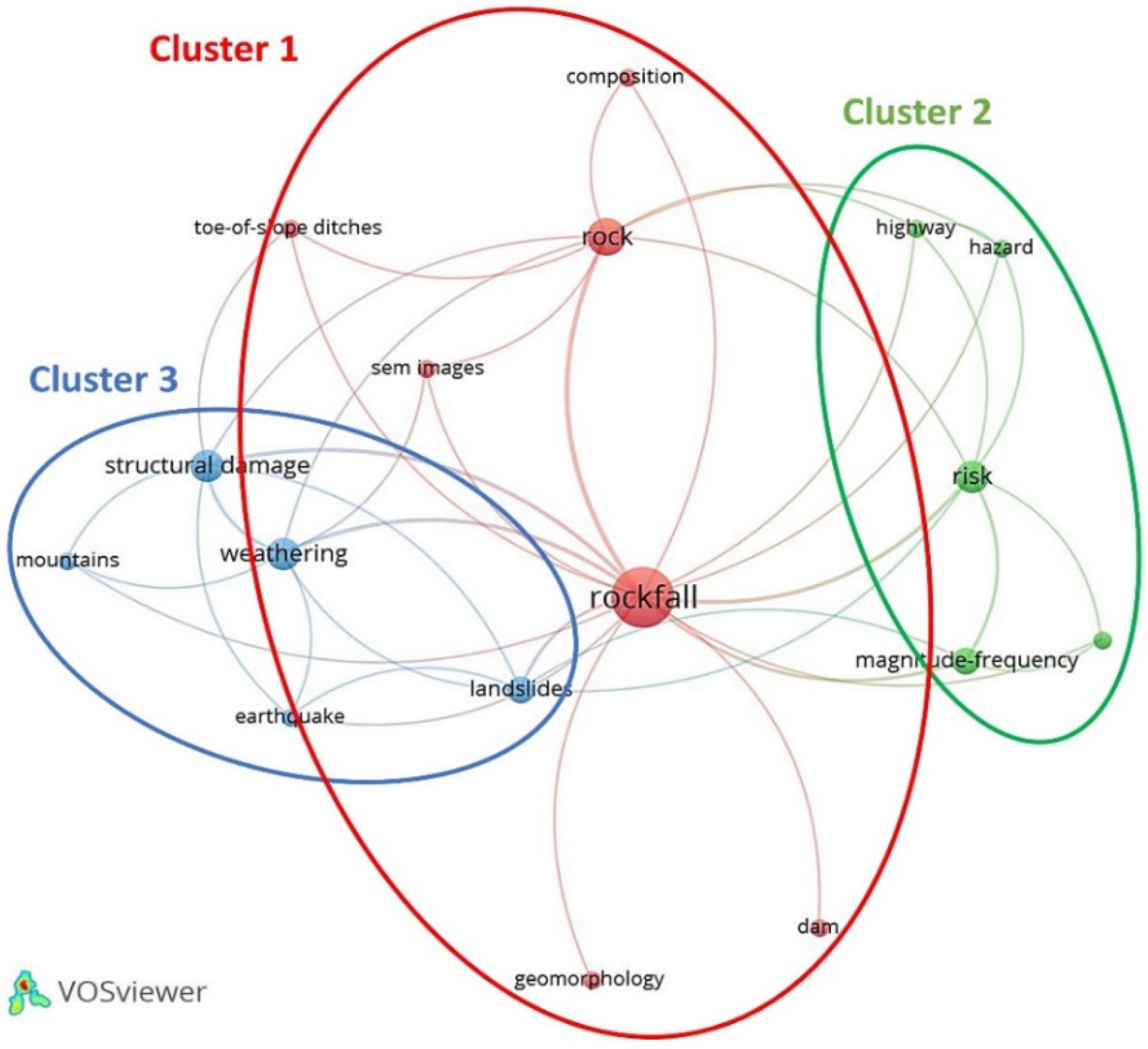
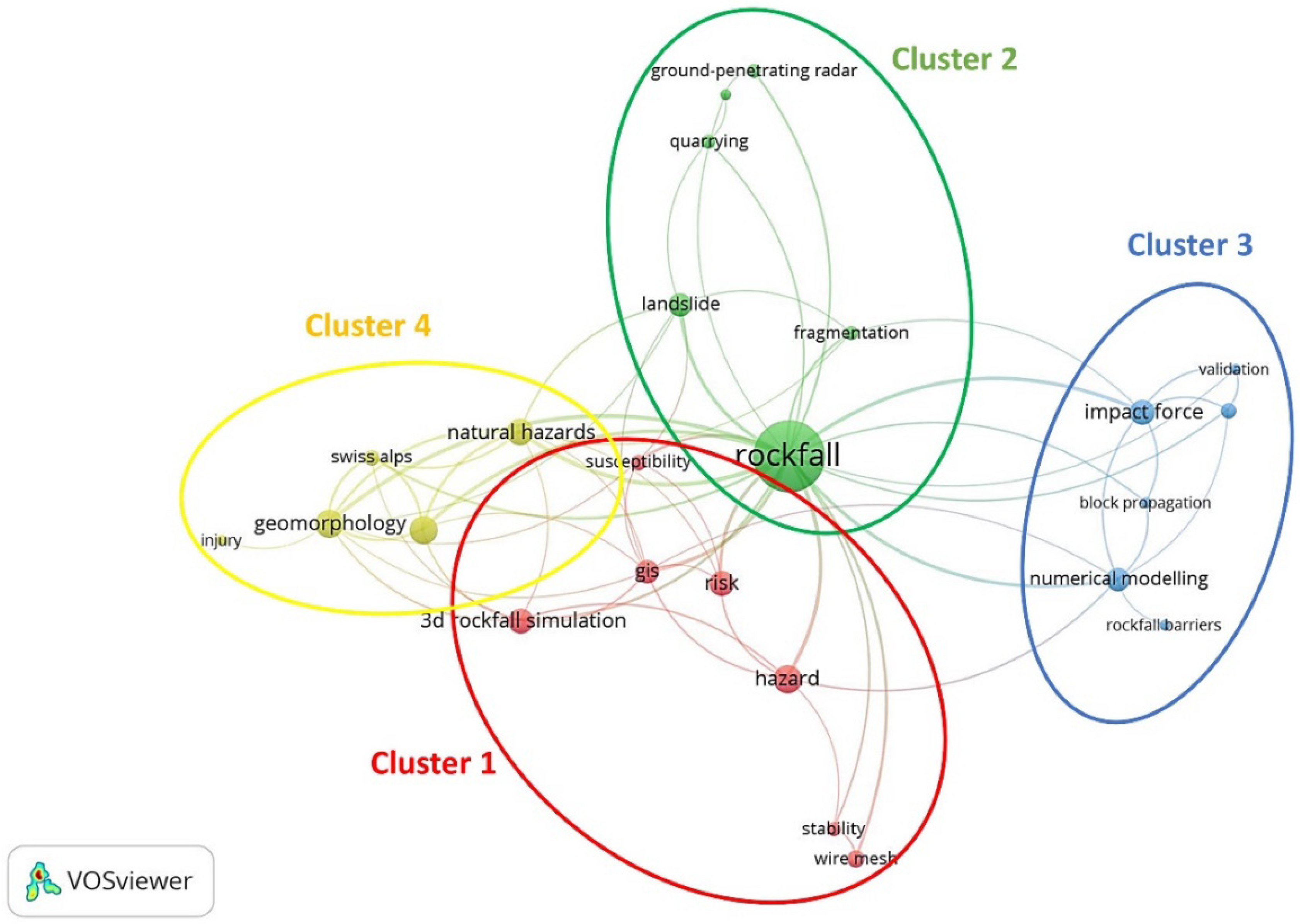
Table 13 shows the evolution and variation of the top 15 author keywords in stage I (1990–1999), stage II (2000–2009) and stage III (2010–2019). Landslide, Rockfall, Risk, and Hazard were the author keywords that appear in all stages. The keywords “susceptibility”, “risk”, “hazard”, and “risk assessment” are aspects of rockfall’s susceptibility assessment. “Risk assessment” and “hazard” refer to a quantitative or qualitative assessment of the classification, volume (or area), and spatial distribution of rock slides that exist or may occur in an area [
9].
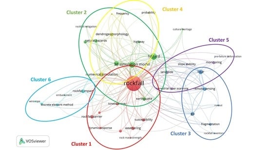
Areas susceptible to rock landslides can be assessed and predicted using empirical methods, analytical methods or kinematic analysis. The need for this type of research caught the attention of researchers and engineers involved in rock landslide risk mitigation and infrastructure planning. The co-occurrence of “hazard” increased continuously, with 1 in 1990–1999 to 12 in 2000–2009 and 46 in 2010–2019; likewise, “risk assessment” (“risk”), with 3 in 1990–1999, to 9 in 2000–2009 and 26 in 2010–2019, suggesting that assessment of rock landslide susceptibility has remained an attractive research topic for the past three decades. “Rockfall” remained the most widely used keyword during the study period because this word was the search argument used in this study.
Rapid developments in remote sensing techniques, “GIS” and “LiDAR” tools made quantitative analysis of rock landslide assessment, analysis and monitoring are more feasible [
117,
140]. Recently, the availability of GIS and remote sensing data has provided many advantages in quantifying topographic attributes related to rock slides. These techniques are also used to create susceptibility maps and hazard and risk maps. “GIS” has undergone an advance since its appearance in the period 2000–2009; while, the term “LiDAR” only appears in this last decade (2010–2019), its co-occurrence has been very high. This pattern indicates that “remote sensing” has become an essential tool to process and analyze spatial data that facilitate the application of quantitative techniques in the evaluation of rockfall risk.
5. Conclusions and Future Trends
This article presents a review of the academic research carried out on Rockfall during the period 1975–2019, along five dimensions: annual production trends, scientific categories (subjects) and journals, author performance and geographic distribution, institution performance, and the temporal evolution of keyword frequencies. This bibliometric analysis will provide researchers involved in rockfall studies with necessary information about rockfall research, such as its main scientific categories (subjects), its main journals, its active countries/territories and institutions, its most productive authors, and its most used keywords from a historical perspective. With this information, researchers can identify the critical points and frontiers of rockfall investigation. A total of 811 publications were analyzed, involving 1293 authors, 267 journals, 54 countries, 158 institutions, and 1598 different keywords author.
Research on Rockfall has grown since 2002 (beginning of Stage II:
Figure 2 and
Table 1), and this increase demonstrates the interest of academics in the fields of Earth and Planetary Sciences, Environmental Science, and Engineering. Global geographical distribution of the authors in rockfall research was visualized cartographically, with important spatial groupings in the EE.UU., Europe, Asia, and Oceania. Developed countries, such as Italy, Switzerland, China, the United States, and France, are responsible for 64.73% of scientific publications in this field worldwide. The most productive institution in terms of publications is Universite Grenoble Alpes (Grenoble, France), with 35 publications, followed by INRAE (National Research Institute for Agriculture, Food and Environment of France) and Chinese Academy of Sciences. The leading journals, according to the number of publications, in this scientific field are Natural Hazards and Earth System Sciences, Landslides, and Geomorphology. Likewise, the prominent authors are Stoffel, M., from the Université de Genève (Genève, Switzerland); Bourrier, F., from the Universite Grenoble Alpes (Grenoble, France), and Jaboyedoff, M., from the Université de Lausanne (Lausanne, Switzerland).
Bibliometry is presented as a suitable methodology for inductive approaches to the semantic limits of the conceptual structure of recently developed disciplines. In our case study on rockfall, we elucidate the multidisciplinary nature of this area of knowledge. The use of bibliometrics can improve our understanding and help researchers to better understand the conceptual structure of rockfall, as in any other scientific field.
A temporal evolution analysis of keyword frequencies was used to shed light on the general research directions and trends in rockfall and to provide reference for future study. In the most recent ten years (2010–2019), several author keywords (
Table 13), such as “hazard”, “3D simulation model”, “risk assessment”, “remote sensing”, “numerical simulation”, “earthquake”, “rockfall barrier”, “LiDAR”, and “GIS”, became the research hotspots in rockfall research, which were in the areas of regional susceptibility assessment, typical deformation monitoring and prediction, effective research technologies, and models. Moreover, two hot issue (hazard-risk assessment and 3D simulation model), one major triggering factor (earthquakes), three research technologies (GIS, LiDAR, and remote sensing), and one effective model (numerical simulation by a algorithms) received steadily increasing attention, indicating likely future rockfall-related research in these areas. From this we can highlight the following topics:
- (i)
For development of a reliable and automatic rockfall monitoring system, remote sensing techniques, such as LiDAR or photogrammetry, have been combined with the development of innovative data processing methods (seismic measurements). Until now, the combination of remote sensing techniques with seismic measurements remains scarce. Therefore, additional calibration work is necessary to corroborate the utility of combining both methods.
- (ii)
For hazard-risk assessment, many machine learning algorithms, such as backpropagation neural network (BPNN), support vector machine (SVM), or using remote sensing (LiDAR, Terrestrial laser scanning-TLS, airborne LiDAR system-ALS, or UAV 3D Photogrammetry), have been widely used to perform the susceptibility assessment. In addition, in recent years, it has been carried out for the protection of Cultural Heritage. This in the frame of a quick protocol for a preliminary zonation, to ensure the safe and sustainable management of the sites.
- (iii)
To determine the trajectories, the potential runout, and impact energies, the use of numerical and models in 2D-3D simulations are being developed, such as: stochastic program (RockGIS) for rockfall fractal fragmentation model (RFFM) or simulation software uses the point-mass model (STONE, RockFall Analyst and PICSUS-ROCKnROLL). However, a greater number of parametric analyses and calibration exercises are required.
- (iv)
GIS-based techniques, physical-based approaches, and also new technologies (such as big-data analysis of monitoring systems) could play an important role in the future for the mitigation and management of rockfall events.
This study had its limitations and implications for future research. First, an opportunity to continue deepening knowledge of rockfall, as a discipline, could be to expand the study using other databases, such as Web of Science (WoS), or using different types of documents and other languages. Second, the research has used the citations provided by the Scopus database as the unit of analysis, so the implications of self-citations and citations should be considered in future research. These could complement the survey so that all the scientific production is considered and the conclusions are more rigorous and better reflect the evolution of disciplinary structures. Furthermore, it would be fascinating to approach the study of intellectual structure through the study of citation, bibliographic coupling, and co-citation because it is a part little explored by bibliometric studies, and it would be of the most significant interest to understand the complete structure of this scientific domain. This analysis of the intellectual structure would reflect the degree of internationalization of a discipline. In addition, a comparative analysis of keyword co-occurrence can be suggested, and results can be compared based on keyword type selection. Here, whether or not taking all the keywords for the analysis could alter the results could be studied.

 ,
, 


