
Spatio-Temporal Trends in Wildlife-Vehicle Collisions: Implications for Socio-Ecological Sustainability

 ,
,  and
and 
Simple Summary
Abstract
1. Introduction
2. Methods
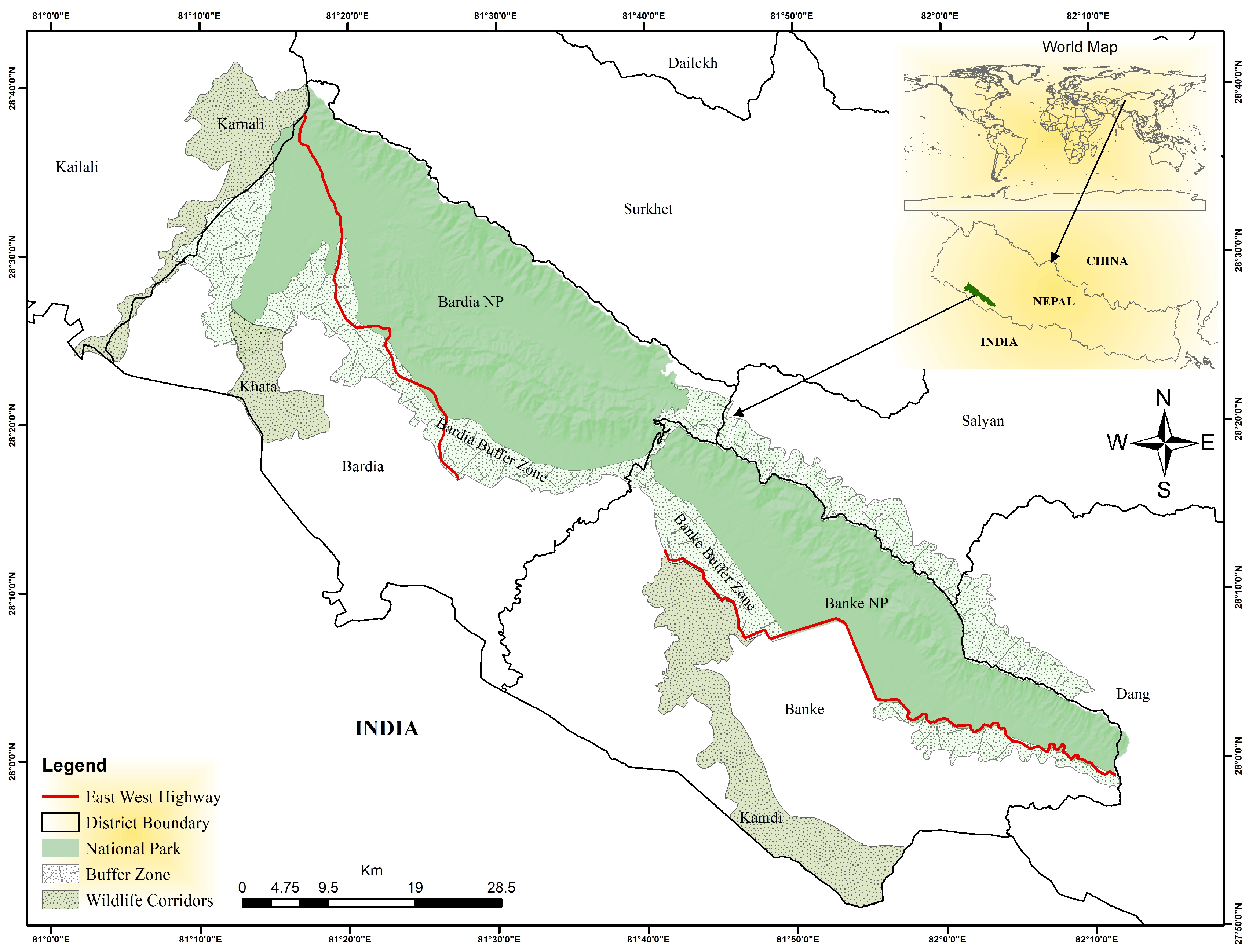
2.1. Study Area
2.2. Data Collection and Analysis
3. Results
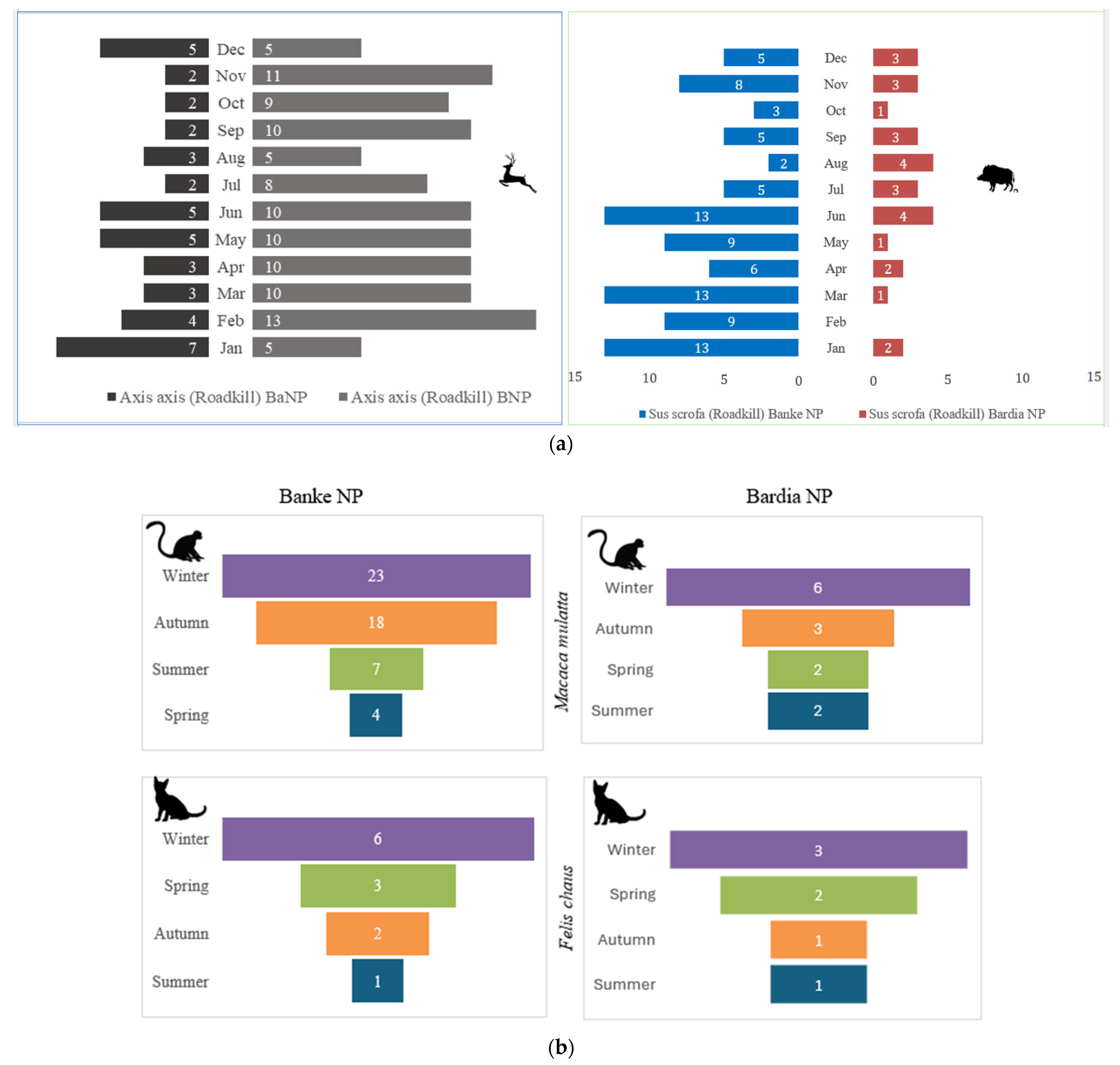
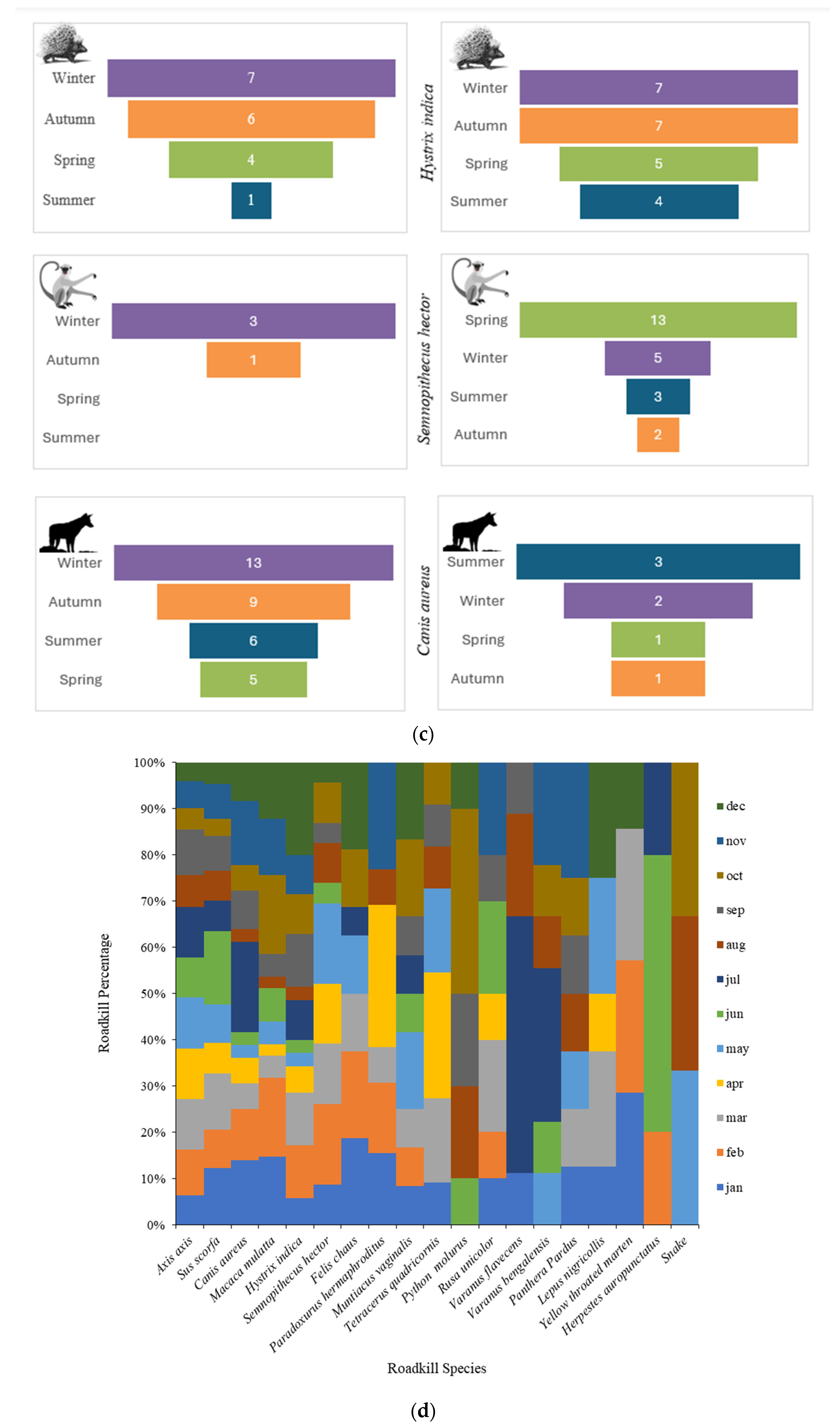
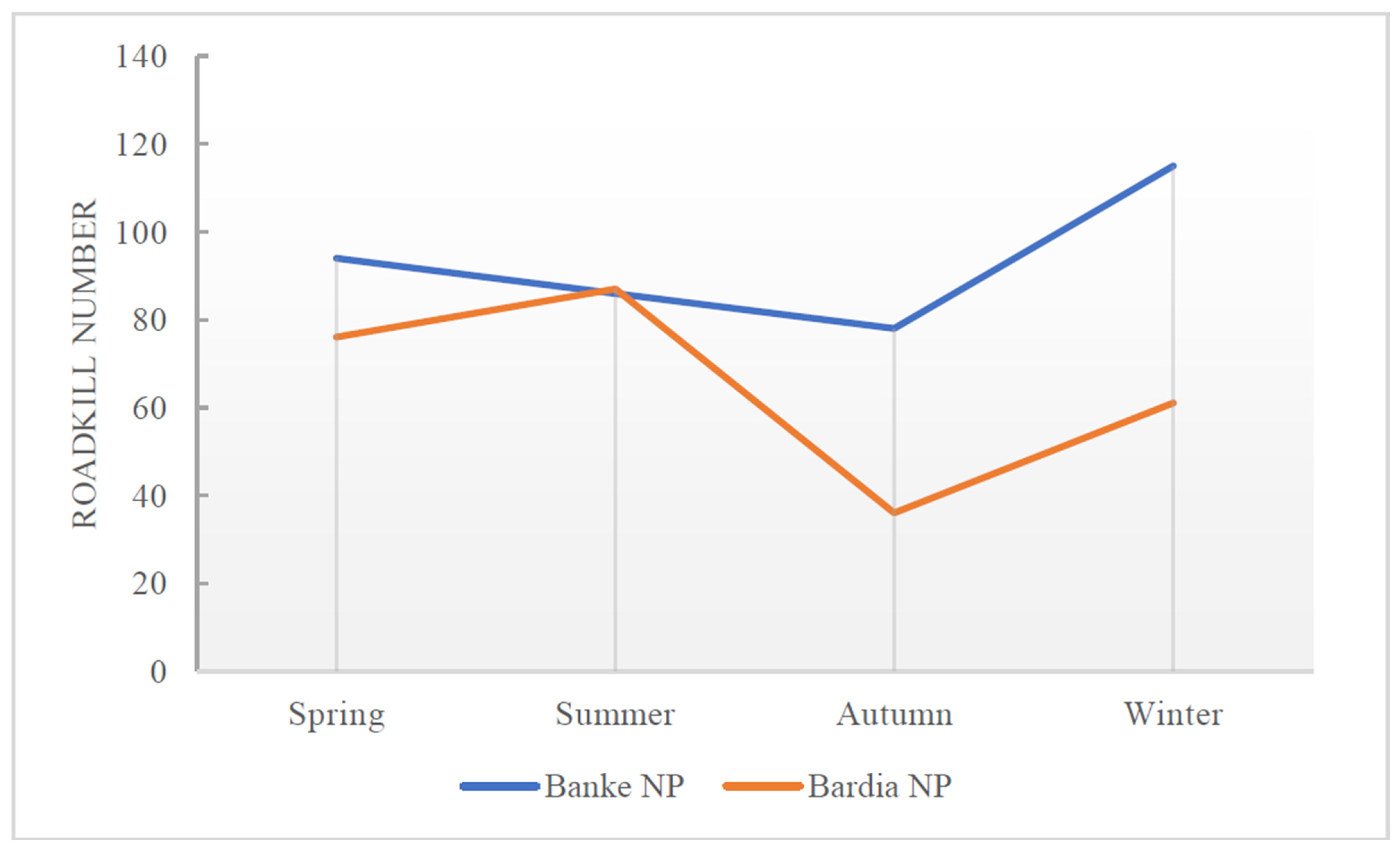
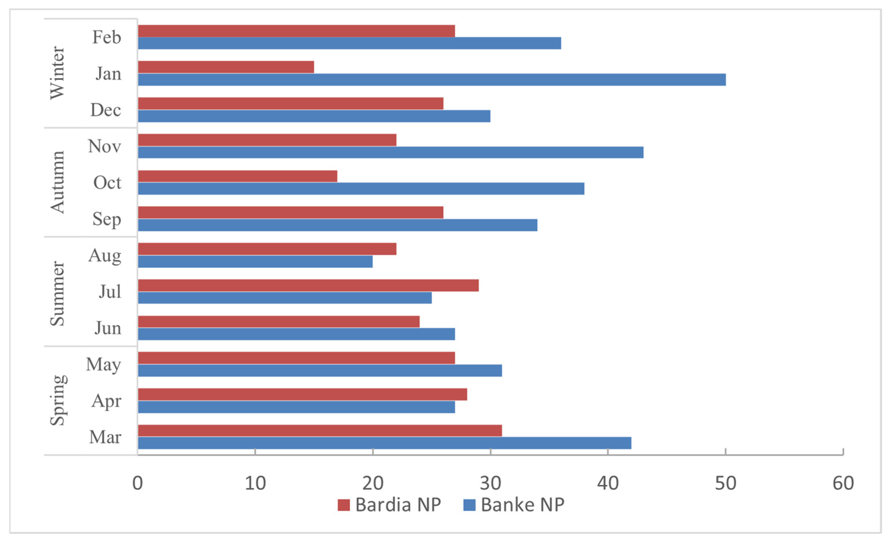
3.1. Roadkill Incidents in the Study Area
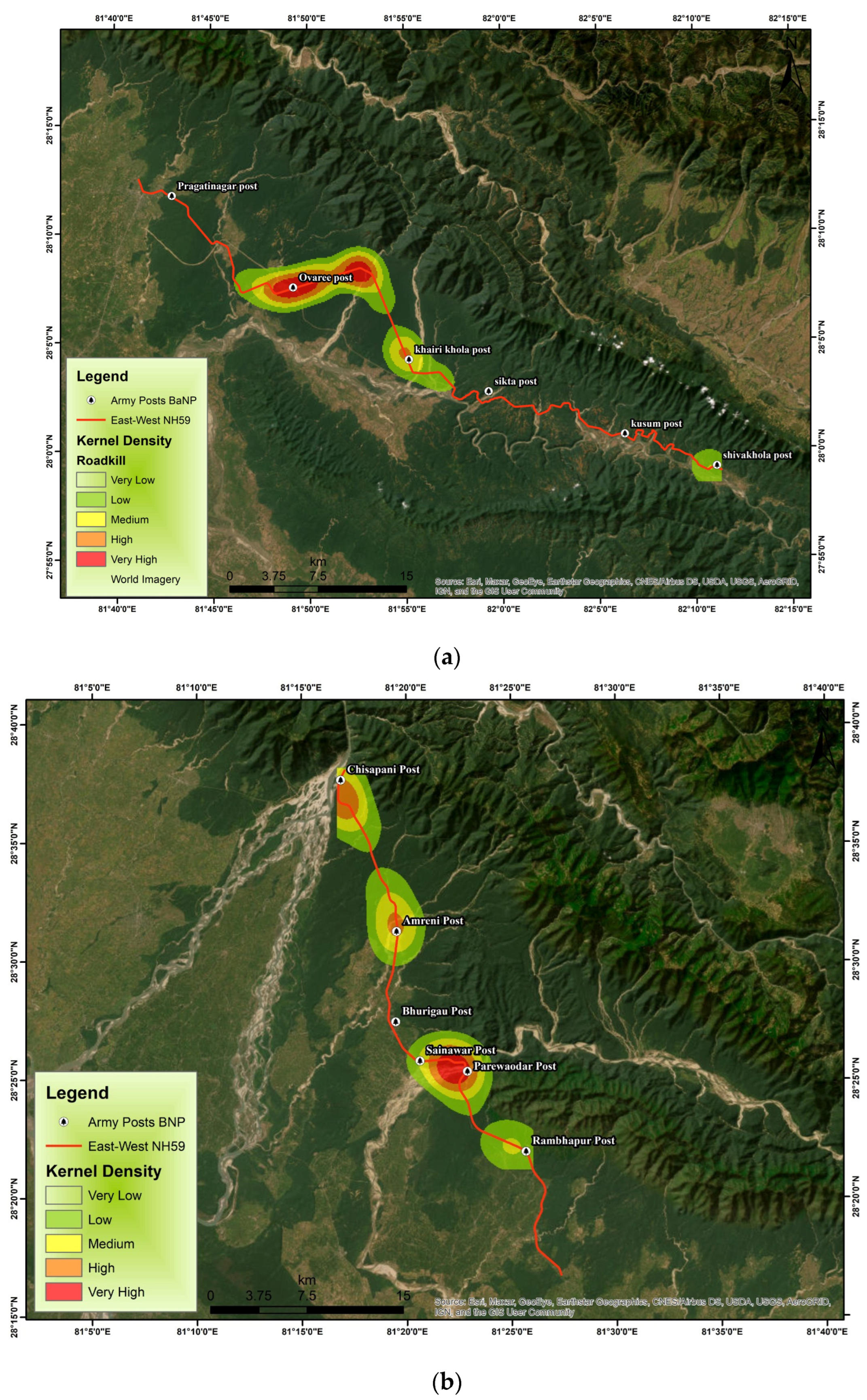
3.2. Hotspot Analysis of Roadkill in Banke and Bardia National Parks
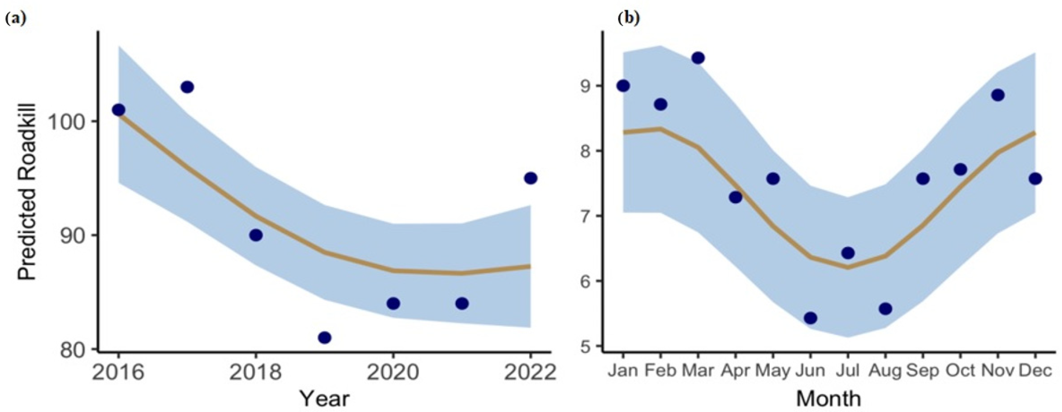
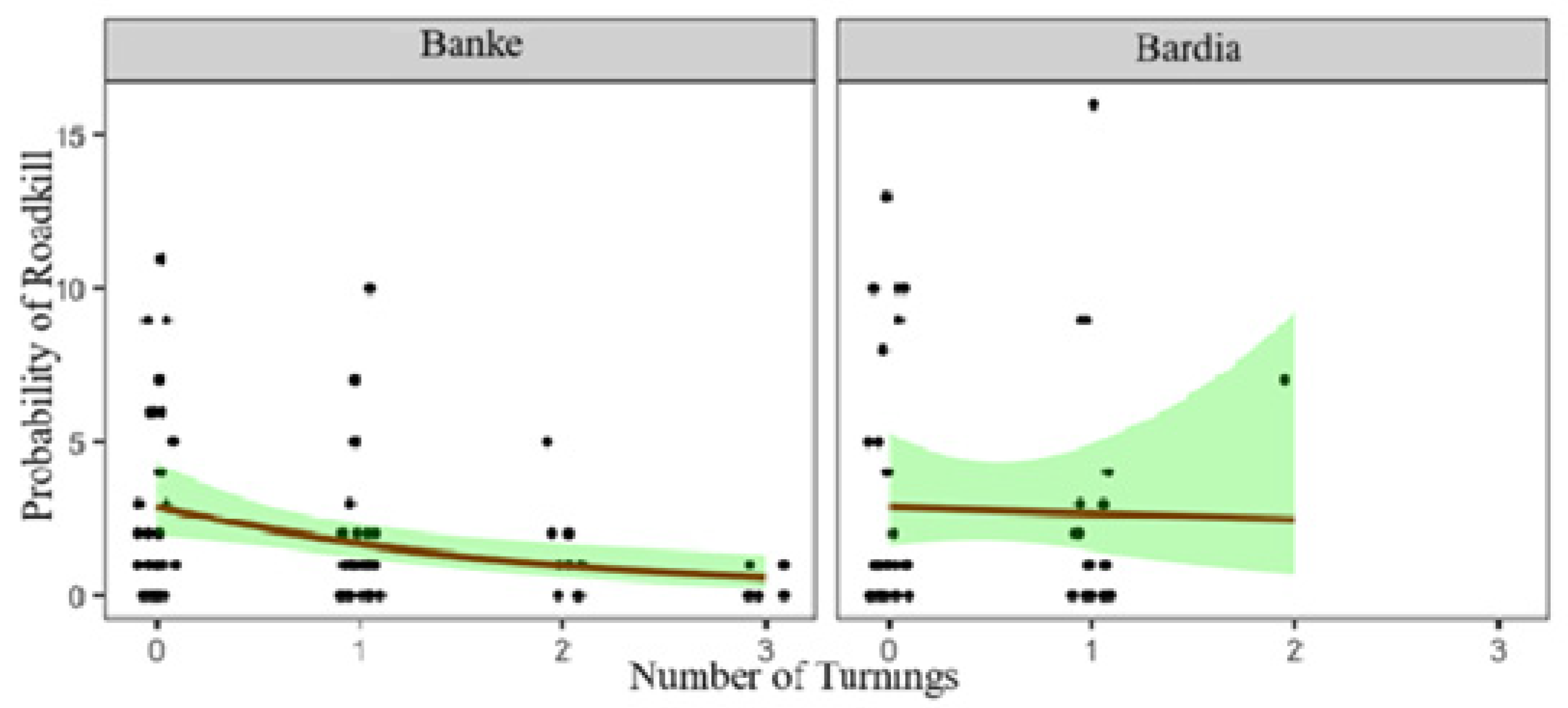
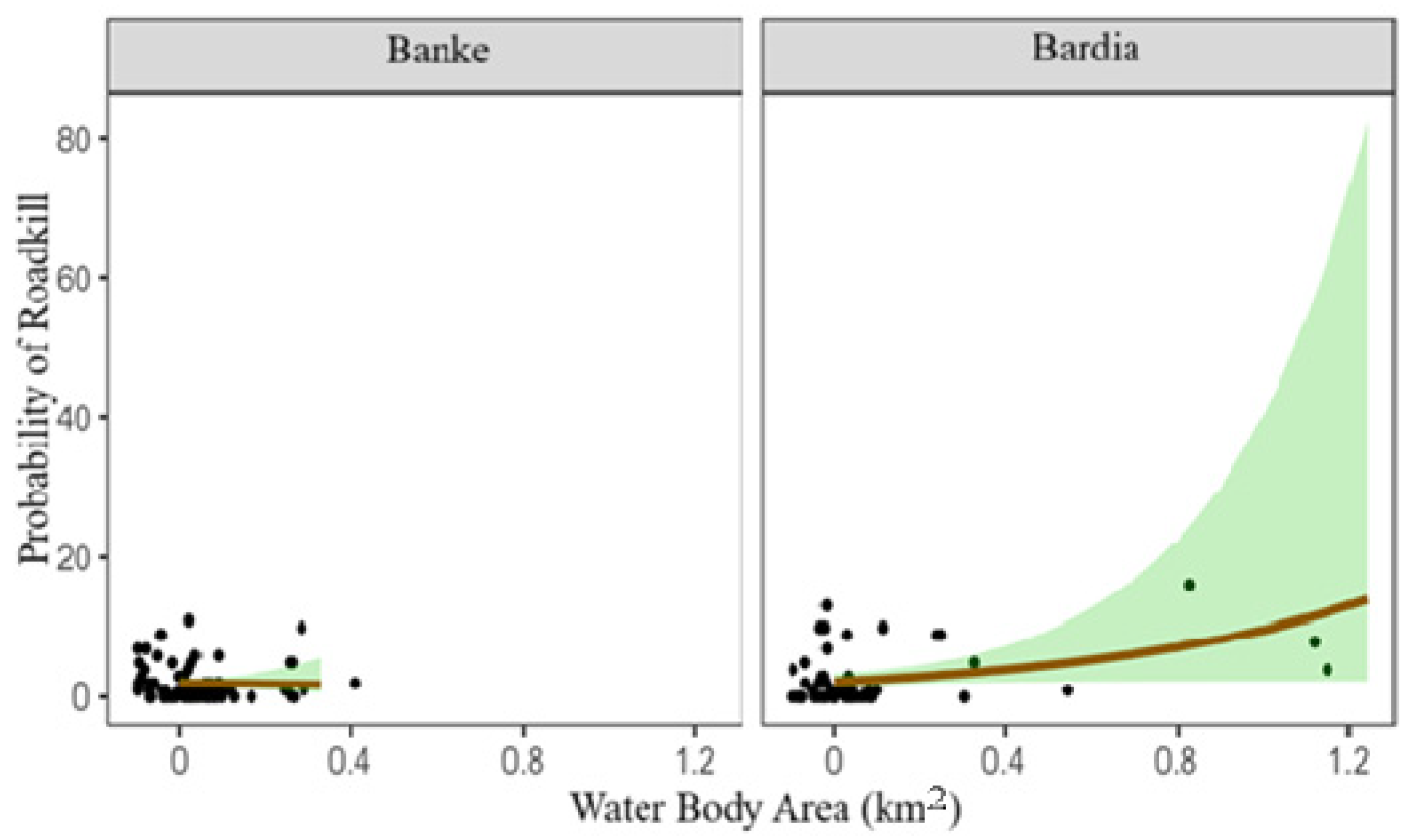
3.3. Relation with Predicted Variables of Roadkill
4. Discussion
5. Conclusions
Author Contributions
Funding
Institutional Review Board Statement
Informed Consent Statement
Data Availability Statement
Acknowledgments
Conflicts of Interest
Appendix A
Appendix A.1

Appendix A.2
Appendix A.3
References
- Sadiq, A.A. Effect of Particulate Emissions from Road Transportation Vehicles on Health of Communities in Urban and Rural Areas, Kano State, Nigeria. Ph.D. Thesis, Université Claude Bernard-Lyon I, Villeurbanne, France, 30 January 2023. [Google Scholar]
- Seiler, A. Predicting Locations of Moose–Vehicle Collisions in Sweden. J. Appl. Ecol. 2005, 42, 371–382. [Google Scholar] [CrossRef]
- Seiler, A. Ecological Effects of Roads: A review; Swedish University of Agricultural Sciences: Uppsala, Sweden, 2001. [Google Scholar]
- Fraser, D.L.; Ironside, K.; Wayne, R.K.; Boydston, E.E. Connectivity of Mule Deer (Odocoileus Hemionus) Populations in a Highly Fragmented Urban Landscape. Landsc. Ecol. 2019, 34, 1097–1115. [Google Scholar] [CrossRef]
- Bennett, V.J. Effects of Road Density and Pattern on the Conservation of Species and Biodiversity. Curr. Landsc. Ecol. Rep. 2017, 2, 1–11. [Google Scholar] [CrossRef]
- Gunson, K.E.; Ireland, D.; Schueler, F. A Tool to Prioritize High-Risk Road Mortality Locations for Wetland-Forest Herpetofauna in Southern Ontario, Canada. North West. J. Zool. 2012, 8, 409–413. [Google Scholar]
- Brown, J.H.; Lomolino, M.V. Concluding remarks: Historical Perspective and the Future of Island Biogeography Theory. Glob. Ecol. Biogeogr. 2000, 9, 87–92. [Google Scholar] [CrossRef]
- Clevenger, A.P.; Wierzchowski, J.; Chruszcz, B.; Gunson, K. GIS-Generated, Expert-Based Models for Identifying Wildlife Habitat Linkages and Planning Mitigation Passages. Conserv. Biol. 2002, 16, 503–514. [Google Scholar] [CrossRef]
- Clevenger, A.P.; Chruszcz, B.; Gunson, K.E. Highway Mitigation Fencing Reduces Wildlife-Vehicle Collisions. Wildl. Soc. Bull. 2001, 29, 646–653. [Google Scholar]
- Jaeger, J.A.G.; Fahrig, L. Effects of Road Fencing on Population Persistence. Conserv. Biol. 2004, 18, 1651–1657. [Google Scholar] [CrossRef]
- Porensky, L.M.; Young, T.P. Edge-Effect Interactions in Fragmented and Patchy Landscapes. Conserv. Biol. 2013, 27, 509–519. [Google Scholar] [CrossRef]
- Carvalho, F.; Mira, A. Comparing Annual Vertebrate Road Kills over Two Time Periods, 9 Years Apart: A Case Study in Mediterranean farmland. Eur. J. Wildl. Res. 2011, 57, 157–174. [Google Scholar] [CrossRef]
- Zhang, C.; Luo, L.; Xu, W.; Ledwith, V. Use of Local Moran’s I and GIS to Identify Pollution Hotspots of Pb in Urban Soils of Galway, Ireland. Sci. Total Environ. 2008, 398, 212–221. [Google Scholar] [CrossRef]
- Guinard, E.; Billon, L.; Bretaud, J.-F.; Chevallier, L.; Sordello, R.; Witté, I. Comparing the Effectiveness of Two Roadkill Survey Methods on Roads. Transp. Res. Part D Transp. Environ. 2023, 121, 103829. [Google Scholar] [CrossRef]
- Hobday, A.J.; Minstrell, M.L. Distribution and Abundance of Roadkill on Tasmanian Highways: Human Management options. Wildl. Res. 2008, 35, 712–726. [Google Scholar] [CrossRef]
- O’Brien, E. Habitat Fragmentation due to Transport Infrastructure: Practical Considerations. In The Ecology of Transportation: Managing Mobility for the Environment; Davenport, J., Davenport, J.L., Eds.; Springer: Dordrecht, The Netherlands, 2006; pp. 191–204. ISBN 978-1-4020-4504-2. [Google Scholar]
- Road Ecology: Science and Solutions; Forman, R.T.T., Ed.; Island Press: Washington, DC, USA, 2003; ISBN 978-1-55963-932-3. [Google Scholar]
- Forman, R.T.T.; Sperling, D.; Bissonette, J.A.; Clevenger, A.P.; Cutshall, C.D.; Dale, V.H.; Fahrig, L.; France, R.; Goldman, C.R.; Heanue, K.; et al. Road Ecology: Science and Solutions; Island Press: Washington, DC, USA, 2003; ISBN 978-1-55963-932-3. [Google Scholar]
- Forman, R.T.T.; Alexander, L.E. Roads and Their Major Ecological Effects. Annual Review of Ecology, Evolution, and Systematics 1998, 29, 207–231. [Google Scholar] [CrossRef]
- Coffin, A.W. From Roadkill to Road Ecology: A Review of the Ecological Effects of Roads. J. Transp. Geogr. 2007, 15, 396–406. [Google Scholar] [CrossRef]
- Langen, M.; Schnack, H.G.; Nederveen, H.; Bos, D.; Lahuis, B.E.; de Jonge, M.V.; van Engeland, H.; Durston, S. Changes in the Developmental Trajectories of Striatum in Autism. Biol. Psychiatry 2009, 66, 327–333. [Google Scholar] [CrossRef]
- Cerqueira, R.C.; Leonard, P.B.; da Silva, L.G.; Bager, A.; Clevenger, A.P.; Jaeger, J.A.G.; Grilo, C. Potential Movement Corridors and High Road-Kill Likelihood Do Not Spatially Coincide for Felids in Brazil: Implications for Road Mitigation. Environ. Manag. 2021, 67, 412–423. [Google Scholar] [CrossRef]
- Zevgolis, Y.G.; Kouris, A.; Christopoulos, A. Spatiotemporal Patterns and Road Mortality Hotspots of Herpetofauna on a Mediterranean Island. Diversity 2023, 15, 478. [Google Scholar] [CrossRef]
- Riley, S.P.D.; Brown, J.L.; Sikich, J.A.; Schoonmaker, C.M.; Boydston, E.E. Wildlife Friendly Roads: The Impacts of Roads on Wildlife in Urban Areas and Potential Remedies. In Urban Wildlife Conservation: Theory and Practice; McCleery, R.A., Moorman, C.E., Peterson, M.N., Eds.; Springer: Boston, MA, USA, 2014; pp. 323–360. ISBN 978-1-4899-7500-3. [Google Scholar]
- Rytwinski, T.; Fahrig, L. Do Species Life History Traits Explain Population Responses to Roads? A Meta-Analysis. Biol. Conserv. 2012, 147, 87–98. [Google Scholar] [CrossRef]
- Collinson, W. A Standardized Protocol for Roadkill Detection and the Determinants of Roadkill in the Greater Mapungubwe Transfrontier Conservation Area, Limpopo Province, South Africa. Ph.D. Dissertation, Rhodes University, Makhanda, South Africa, 2013. [Google Scholar]
- Lala, F.; Chiyo, P.I.; Kanga, E.; Omondi, P.; Ngene, S.; Severud, W.J.; Morris, A.W.; Bump, J. Wildlife Roadkill in the Tsavo Ecosystem, Kenya: Identifying hotspots, Potential Drivers, and Affected Species. Heliyon 2021, 7, e06364. [Google Scholar] [CrossRef]
- Su, H.; Wang, Y.; Yang, Y.; Tao, S.; Kong, Y. An Analytical Framework of the Factors Affecting Wildlife–Vehicle Collisions and Barriers to Movement. Sustainability 2023, 15, 11181. [Google Scholar] [CrossRef]
- Collinson, W.J.; Parker, D.M.; Bernard, R.T.F.; Reilly, B.K.; Davies-Mostert, H.T. Factors Influencing the Spatial Patterns of Vertebrate Roadkill in South Africa: The Greater Mapungubwe Transfrontier Conservation Area as a case study. Afr. J. Ecol. 2019, 57, 552–564. [Google Scholar] [CrossRef]
- van Langevelde, F.; Jaarsma, C.F. Using Traffic Flow Theory to Model Traffic Mortality in Mammals. Landsc. Ecol 2005, 19, 895–907. [Google Scholar] [CrossRef]
- Department of National Parks and Wildlife Conservation. Annual Progress Report (Fiscal Year: 2022/023); Government of Nepal, Ministry of Forests and Environment: Kathmandu, Nepal, 2023; p. 154.
- Dahal, N.; Shrestha, U.B.; Tuitui, A.; Ojha, H.R. Temporal Changes in Precipitation and Temperature and their Implications on the Streamflow of Rosi River, Central Nepal. Climate 2019, 7, 3. [Google Scholar] [CrossRef]
- Adhikari, B.; Baral, K.; Bhandari, S.; Szydlowski, M.; Kunwar, R.M.; Panthi, S.; Neupane, B.; Koirala, R.K. Potential Risk Zone for Anthropogenic Mortality of Carnivores in Gandaki Province, Nepal. Ecol. Evol. 2022, 12, e8491. [Google Scholar] [CrossRef]
- Bhandari, K.; Upadhaya, S.; Yadav, N.K.; Poudel, P.; Heyojoo, B.P.; Timilsina, Y.P.; Koirala, P. What factors drive wildlife-vehicle collisions on highways? A case study from Western Nepal. J. Nat. Conserv. 2024, 81, 126678. [Google Scholar] [CrossRef]
- Collinson, W.J.; Parker, D.M.; Bernard, R.T.F.; Reilly, B.K.; Davies-Mostert, H.T. Wildlife Road Traffic Accidents: A Standardized Protocol for Counting Flattened Fauna. Ecol. Evol. 2014, 4, 3060–3071. [Google Scholar] [CrossRef]
- Roger, E.; Laffan, S.W.; Ramp, D. Road Impacts a Tipping Point for Wildlife Populations in Threatened Landscapes. Popul. Ecol. 2011, 53, 215–227. [Google Scholar] [CrossRef]
- Gaire, A.; Bagale, D.; Acharya, P.; Acharya, R.H. Spatial and Temporal Variability of Rainfall in the Western Region of Nepal. J. Hydrol. Meteorol. 2024, 12, 68–80. [Google Scholar] [CrossRef]
- Oli, C.B.; Panthi, S.; Subedi, N.; Ale, G.; Pant, G.; Khanal, G.; Bhattarai, S. Dry Season Diet Composition of Four-Horned Antelope Tetracerus Quadricornis in Tropical Dry Deciduous Forests, Nepal. PeerJ 2018, 6, e5102. [Google Scholar] [CrossRef]
- Pandey, H.P.; Maraseni, T.N.; Apan, A.; Pokhrel, S.; Zhang, H. Lessons from a Participatory Forest Restoration Program on Socio-Ecological and Environmental Aspects in Nepal. Trees For. People 2025, 20, 100854. [Google Scholar] [CrossRef]
- Pandey, H.P.; Aryal, K.; Aryal, S.; Maraseni, T.N. Understanding Local Ecosystem Dynamics in Three Provinces of the Lowlands of Nepal. Sci. Total Environ. 2023, 867, 161501. [Google Scholar] [CrossRef]
- Pandey, H.P.; Maraseni, T.N.; Apan, A. Assessing the Theoretical Scope of Environmental Justice in Contemporary Literature and Developing a Pragmatic Monitoring Framework. Sustainability 2024, 16, 10799. [Google Scholar] [CrossRef]
- Pandey, H.P.; Maraseni, T.N.; Apan, A.; Zhang, H. Review Articles on Ecological Resettlements: Insights, Gaps, and Pathways. Sustainability 2025, 17, 4094. [Google Scholar] [CrossRef]
- BaNP Banke National Park. Department of National Park and Wildlife Conservation. Available online: https://dnpwc.gov.np/en/conservation-area-detail/79/ (accessed on 3 May 2025).
- BNP Bardiya National Park. Department of National Park and Wildlife Conservation. Available online: https://dnpwc.gov.np/en/conservation-area-detail/80/ (accessed on 3 May 2025).
- Shah, K.K.; Tiwari, I.; Modi, B.; Pandey, H.P.; Subedi, S.; Shrestha, J. Shisham (Dalbergia Sissoo) Decline by Dieback Disease, Root Pathogens and Their Management: A Review. J. Agric. Nat. Resour. 2021, 4, 255–272. [Google Scholar] [CrossRef]
- Weather and Climate Banke, Bheri, NP Climate Zone, Monthly Averages, Historical Weather Data. Available online: https://weatherandclimate.com/nepal/bheri/banke (accessed on 3 May 2025).
- Weather and Climate Bardiya, Bheri, NP Climate Zone, Monthly Averages, Historical Weather Data. Available online: https://weatherandclimate.com/nepal/bheri/bardiya (accessed on 3 May 2025).
- DoR Road Statistics and Documents. Department of Roads. Available online: https://www.dor.gov.np/home/page/road-statistics-and-documents (accessed on 17 April 2025).
- IUCN The IUCN Red List of Threatened Species. Available online: https://www.iucnredlist.org/en (accessed on 17 April 2025).
- Jnawali, S.; Baral, H.; Lee, S.; Acharya, K.; Upadhyay, G.; Pandey, M.; Shrestha, M.; Joshi, D.; Lamichhane, B.; Griffiths, J.; et al. The Status of Nepal Mammals: The National Red List Series; Department of National Parks and Wildlife Conservation: Kathmandu, Nepal, 2011.
- R Core Team. A Language and Environment for Statistical Computing, Version 4.3.1; R Foundation for Statistical Computing: Vienna, Austria, 2023; Available online: https://www.R-project.org/ (accessed on 2 November 2023).
- RStudio Desktop Posit. Integrated Development Environment for R, version 2023.12.0.369; Posit Software: PBC: Boston, MA, USA, 2023; Available online: https://www.posit.co/ (accessed on 1 May 2025).
- Wood, S.N. Generalized Additive Models: An Introduction with R, Second Edition, 2nd ed.; Chapman and Hall/CRC: New York, NY, USA, 2017; ISBN 978-1-315-37027-9. [Google Scholar]
- Wickham, H. Ggplot2: Elegant Graphics for Data Analysis; Springer: New York, NY, 2009; ISBN 978-0-387-98140-6. [Google Scholar]
- Department of National Parks and Wildlife Conservation; Department of Forests and Soil Conservation. Status of Tigers and Prey in Nepal; Ministry of Forests and Environment: Kathmandu, Nepal, 2022.
- Fahrig, L.; Baudry, J.; Brotons, L.; Burel, F.G.; Crist, T.O.; Fuller, R.J.; Sirami, C.; Siriwardena, G.M.; Martin, J.-L. Functional Landscape Heterogeneity and Animal Biodiversity in Agricultural Landscapes. Ecol. Lett. 2011, 14, 101–112. [Google Scholar] [CrossRef]
- Mccollister, M.F.; Van Manen, F.T. Effectiveness of Wildlife Underpasses and Fencing to Reduce Wildlife-Vehicle Collisions. J. Wildl. Manag. 2010, 74, 1722–1731. [Google Scholar] [CrossRef]
- Huijser, M.P.; Mosler-Berger, C.; Olsson, M.; Strein, M. Wildlife Warning Signs and Animal Detection Systems Aimed at Reducing Wildlife-Vehicle Collisions. In Handbook of Road Ecology; John and Wiley and Sons: Hoboken, NJ, USA, 2015; pp. 198–212. ISBN 978-1-118-56817-0. [Google Scholar]
- Verde Arregoitia, L.D.; D’Elía, G. Classifying Rodent Diets for Comparative Research. Mammal Rev. 2021, 51, 51–65. [Google Scholar] [CrossRef]
- Maharjan, A.; Maraseni, T.; Allen, B.L.; Apan, A. Assessing the Spatio-temporal Activity Pattern and Habitat Use of Bengal Tiger (Panthera Tigris Tigris) Across Three Forest Management Regimes in Nepal. Biodivers. Conserv. 2025, 34, 643–663. [Google Scholar] [CrossRef]
- Khadka, A.; Gautam, P.; Joshi, E.; Pilkington, P.; Parkin, J.; Joshi, S.K.; Mytton, J. Road Safety and Heavy Goods Vehicle Driving in LMICs: Qualitative Evidence from Nepal. J. Transp. Health 2021, 23, 101247. [Google Scholar] [CrossRef]
- Van Der Hoeven, C.A.; De Boer, W.F.; Prins, H.H.T. Roadside Conditions as Predictor for Wildlife Crossing Probability in a Central African Rainforest. Afr. J. Ecol. 2010, 48, 368–377. [Google Scholar] [CrossRef]
- van der Ree, R.; Smith, D.J.; Grilo, C. The Ecological Effects of Linear Infrastructure and Traffic. In Handbook of Road Ecology; John and Wiley and Sons: Hoboken, NJ, USA, 2015; pp. 1–9. ISBN 978-1-118-56817-0. [Google Scholar]
- Kumar, N.S.; Karanth, K.U.; Nichols, J.D.; Vaidyanathan, S.; Gardner, B.; Krishnaswamy, J. Introduction: The Conservation Issue. In Spatial Dynamics and Ecology of Large Ungulate Populations in Tropical Forests of India; Kumar, N.S., Karanth, K.U., Nichols, J.D., Vaidyanathan, S., Gardner, B., Krishnaswamy, J., Eds.; Springer: Singapore, 2021; pp. 1–33. ISBN 9789811569340. [Google Scholar]
- Schaller, G.B. The Deer and the Tiger; University of Chicago Press: Chicago, IL, USA, 2009; ISBN 978-0-226-73657-0. [Google Scholar]
- Sosa, R.; Schalk, C.M. Seasonal Activity and Species Habitat Guilds Influence Road-Kill Patterns of Neotropical Snakes. Trop. Conserv. Sci. 2016, 9, 1940082916679662. [Google Scholar] [CrossRef]
- Ramachandra, T.V.; Bharath, S.; Vinay, S. Visualisation of Impacts due to the Proposed Developmental Projects in the Ecologically Fragile Regions—Kodagu district, Karnataka. Prog. Disaster Sci. 2019, 3, 100038. [Google Scholar] [CrossRef]
- Cassimiro, I.M.F.; Ribeiro, M.C.; Assis, J.C. How Did the Animal Come to Cross the Road? Drawing Insights on Animal Movement from Existing Roadkill Data and Expert Knowledge. Landsc. Ecol. 2023, 38, 2035–2051. [Google Scholar] [CrossRef]
- Develey, P.F.; Stouffer, P.C. Effects of Roads on Movements by Understory Birds in Mixed-Species Flocks in Central Amazonian Brazil. Conserv. Biol. 2001, 15, 1416–1422. [Google Scholar] [CrossRef]
- Jakubas, D.; Ryś, M.; Lazarus, M. Factors Affecting Wildlife-Vehicle Collision on the Expressway in a Suburban Area in Northern Poland. North West. J. Zool. 2018, 14, 107–116. [Google Scholar]


| Term | Estimate | Std. Error | z-Value | p-Value | edf | Chi-sq |
|---|---|---|---|---|---|---|
| Intercept | 2.02 | 0.044 | 45.64 | <0.001 | - | - |
| s (Year) | - | - | - | 0.369 | 1.45 | 1.25 |
| s (Month) | - | - | - | 0.008 | 1.94 | 7.73 |
| Coefficients | Estimate | SE | z Value | Pr(>|z|) | CI.Lower | CI.Upper |
|---|---|---|---|---|---|---|
| Intercept | 0.4683 | 0.455 | 1.029 | 0.3034 | −0.467 | 1.417 |
| Crop Land (km2) | −0.2483 | 0.1385 | −1.793 | 0.073 | −0.537 | 0.039 |
| Forest (km2) | 0.2343 | 0.122 | 1.92 | 0.0549 | −0.028 | 0.505 |
| Water Body (km2) | 1.2214 | 0.615 | 1.986 | 0.0471 | 0.050 | 2.712 |
| No. of Turnings | −0.395 | 0.1662 | −2.377 | 0.0174 | −0.729 | −0.061 |
Disclaimer/Publisher’s Note: The statements, opinions and data contained in all publications are solely those of the individual author(s) and contributor(s) and not of MDPI and/or the editor(s). MDPI and/or the editor(s) disclaim responsibility for any injury to people or property resulting from any ideas, methods, instructions or products referred to in the content. |
© 2025 by the authors. Licensee MDPI, Basel, Switzerland. This article is an open access article distributed under the terms and conditions of the Creative Commons Attribution (CC BY) license (https://creativecommons.org/licenses/by/4.0/).
Share and Cite
Thakur, M.S.; Aryal, P.C.; Pandey, H.P.; Maraseni, T.N. Spatio-Temporal Trends in Wildlife-Vehicle Collisions: Implications for Socio-Ecological Sustainability. Animals 2025, 15, 1478. https://doi.org/10.3390/ani15101478
Thakur MS, Aryal PC, Pandey HP, Maraseni TN. Spatio-Temporal Trends in Wildlife-Vehicle Collisions: Implications for Socio-Ecological Sustainability. Animals. 2025; 15(10):1478. https://doi.org/10.3390/ani15101478
Chicago/Turabian StyleThakur, Manju Shree, Prakash Chandra Aryal, Hari Prasad Pandey, and Tek Narayan Maraseni. 2025. "Spatio-Temporal Trends in Wildlife-Vehicle Collisions: Implications for Socio-Ecological Sustainability" Animals 15, no. 10: 1478. https://doi.org/10.3390/ani15101478
APA StyleThakur, M. S., Aryal, P. C., Pandey, H. P., & Maraseni, T. N. (2025). Spatio-Temporal Trends in Wildlife-Vehicle Collisions: Implications for Socio-Ecological Sustainability. Animals, 15(10), 1478. https://doi.org/10.3390/ani15101478