
Robust Algorithms for Drone-Assisted Monitoring of Big Animals in Harsh Conditions of Siberian Winter Forests: Recovery of European elk (Alces alces) in Salair Mountains


Abstract
:Simple Summary
Abstract
1. Introduction
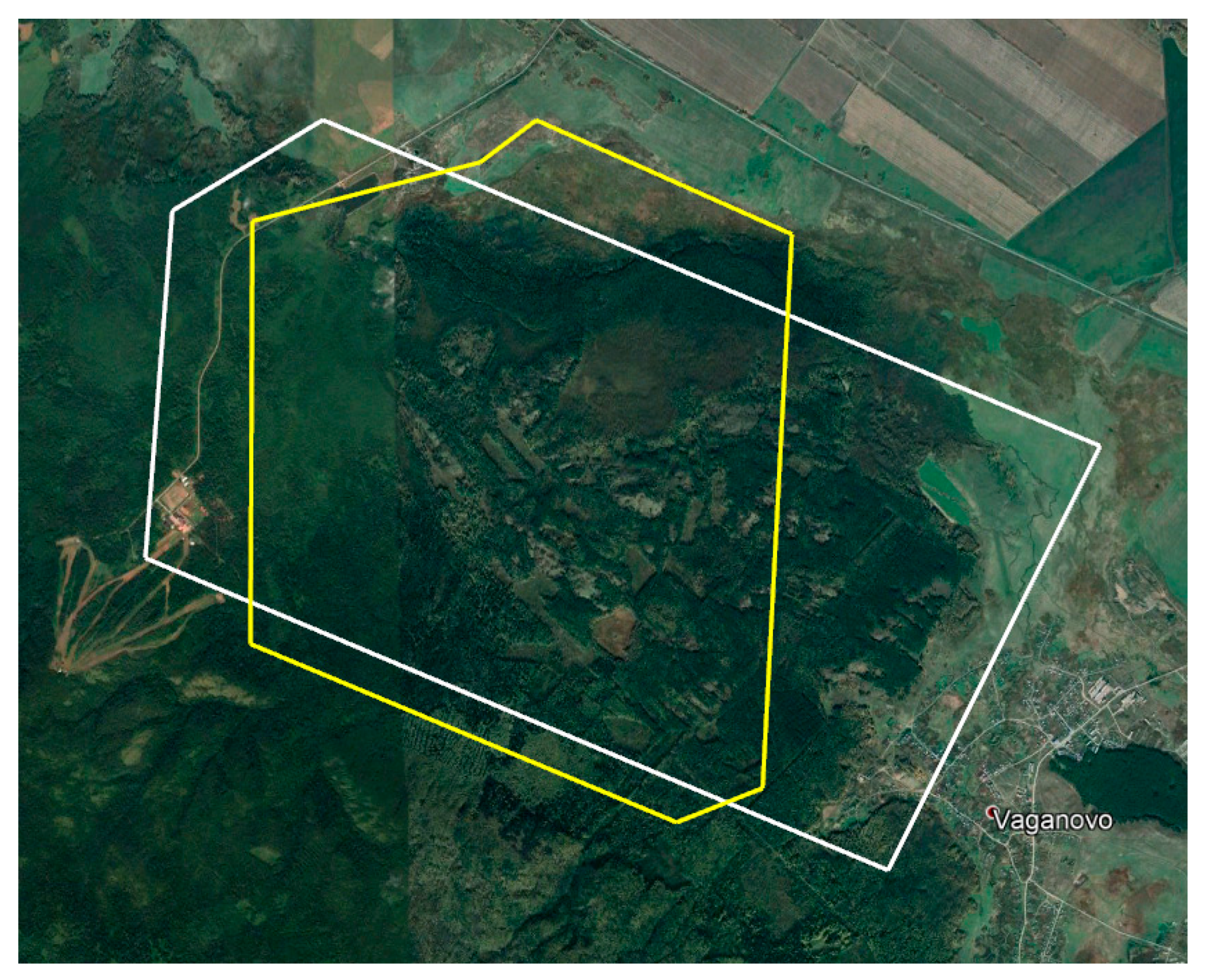
2. Methods
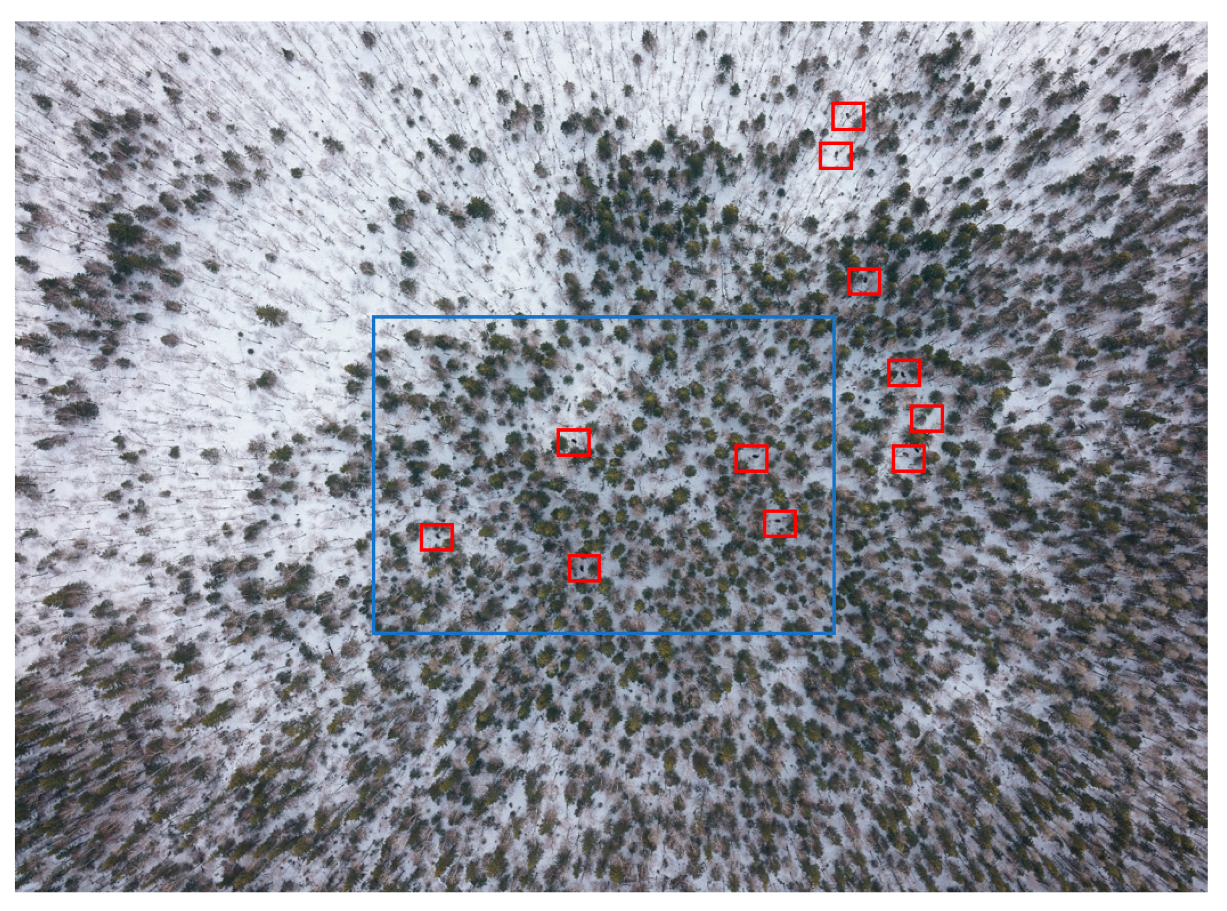
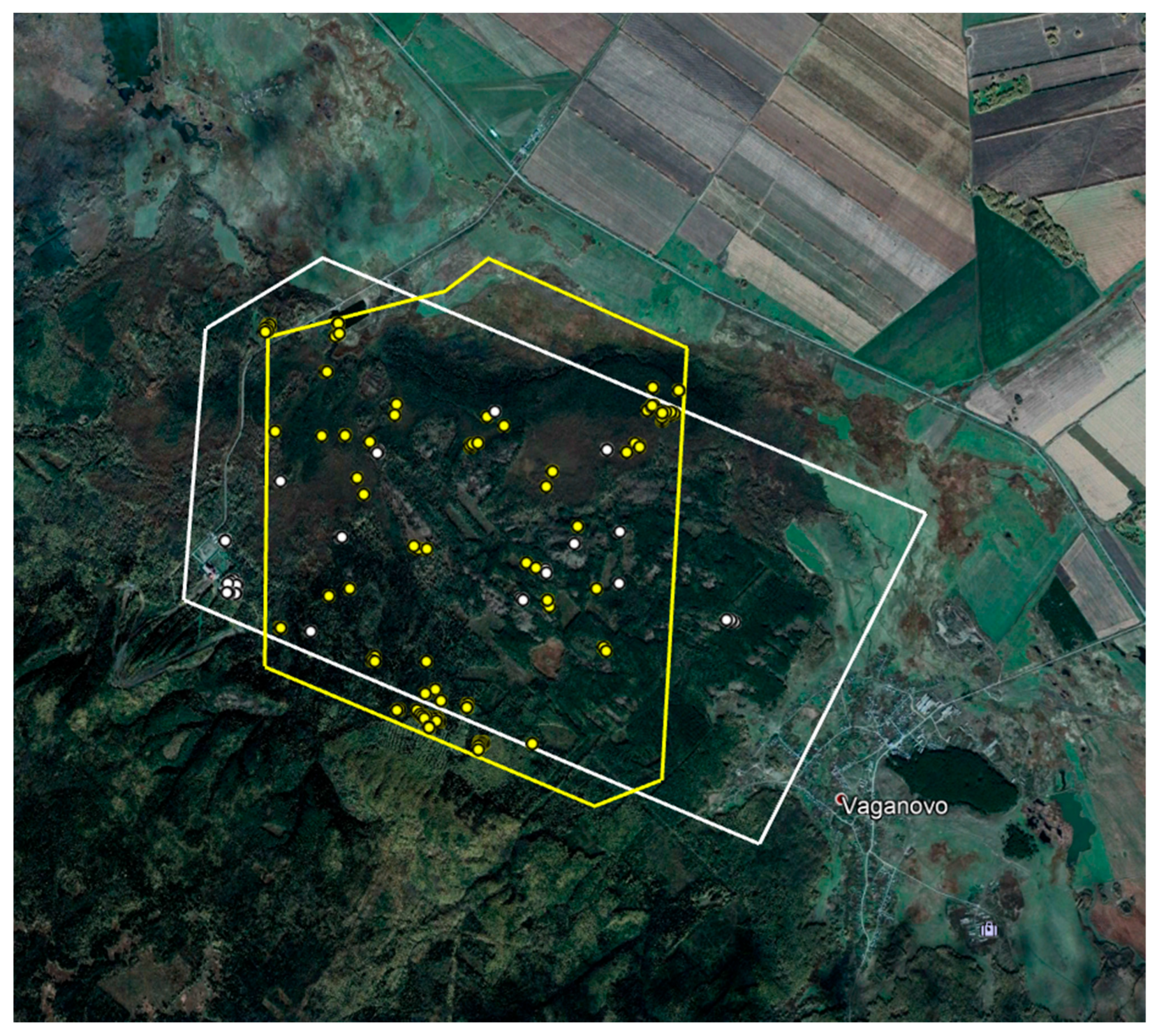
3. Results and Discussion
- (1)
- We sequenced the infrared video with an interval of ~0.6 s.
- (2)
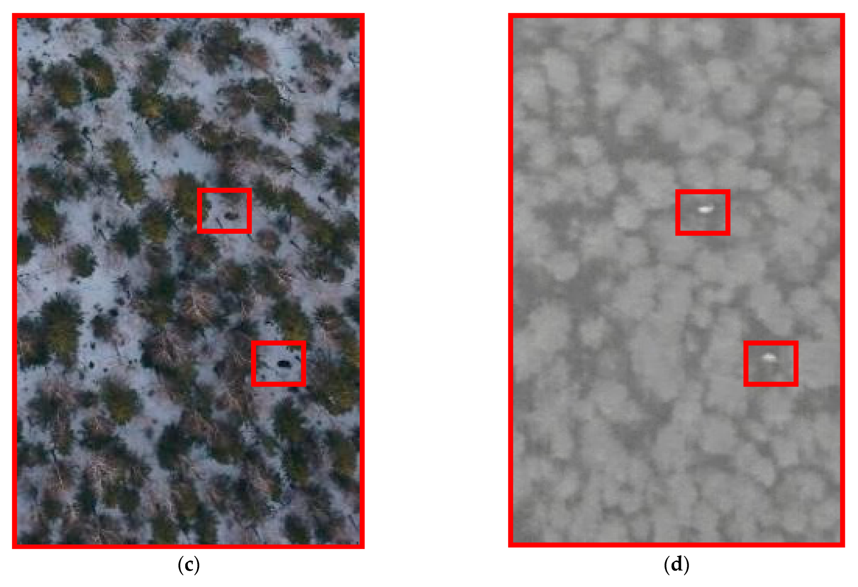
- After that, the infrared images were processed using software according to the degree of color intensity and pixel clusters. As a result, we obtained numerous infrared images with thermal extremes, which indicated an object with a higher temperature than that of the snow, e.g., an animal, a human, or a car.
- (3)
- We uploaded the RGB photos and telemetry into the Agisoft Metashape Professional software for alignment.
- (4)
- The infrared images underwent a visual inspection for the initial screening of “junk” data.
- (5)
- The coordinates of the infrared images with extremes were compared in-camera with the aligned RGB photographs, and the presence of large game was determined visually.
- (6)
- Finally, we compared the research results at different stages.
4. Conclusions
- (1)
- Aerial surveys are a promising practical method for determining the population of large ungulate animals, e.g., elks, roe deer, wild boars (Sus scrofa), red deer, as well as wolves.
- (2)
- Drone-mounted thermal infrared cameras provide accurate data on the animal presence in the winter period. The combined use of RGB images and thermal-imaging cameras allows for reliable identification of the thermal signature of the detected object.
- (3)
- The method can be used to check the data obtained by traditional survey methods, i.e., as a part of a complex survey.
- (4)
- Unmanned aerial vehicles make it possible to monitor vast forest areas in a short period of time. This advantage allows scientists to observe animal behavior in winter.
Supplementary Materials
Author Contributions
Funding
Institutional Review Board Statement
Informed Consent Statement
Data Availability Statement
Conflicts of Interest
References
- Venter, O.; Sanderson, E.W.; Magrach, A.; Allan, J.R.; Beher, J.; Jones, K.R.; Possingham, H.P.; Laurance, W.F.; Wood, P.; Fekete, B.M.; et al. Sixteen years of change in the global terrestrial human footprint and implications for biodiversity conservation. Nat. Commun. 2016, 7, 12558. [Google Scholar] [CrossRef] [Green Version]
- Andreozzi, H.A.; Pekins, P.J.; Kantar, L.E. Using aerial survey observations to identify winter habitat use of moose in northern maine. Alces A J. Devoted Biol. Manag. Moose 2016, 52, 41–53. [Google Scholar]
- Rickbeil, G.J.M.; Merkle, J.A.; Anderson, G.; Atwood, M.P.; Beckmann, J.P.; Cole, E.K.; Courtemanch, A.B.; Dewey, S.; Gustine, D.D.; Kauffman, M.J.; et al. Plasticity in elk migration timing is a response to changing environmental conditions. Glob. Chang. Biol. 2019, 25, 2368–2381. [Google Scholar] [CrossRef]
- Smith, T.N.; Rota, C.T.; Keller, B.J.; Chitwood, M.C.; Bonnot, T.W.; Hansen, L.P.; Millspaugh, J.J. Resource selection of a recently translocated elk population in Missouri: Resource Selection of Translocated Elk. J. Wildl. Manag. 2019, 83, 365–378. [Google Scholar] [CrossRef]
- Cepic, M.; Bechtold, U.; Wilfing, H. Modelling human influences on biodiversity at a global scale–A human ecology perspective. Ecol. Model. 2022, 465, 109854. [Google Scholar] [CrossRef]
- Newbold, T.; Hudson, L.N.; Hill, S.L.; Contu, S.; Lysenko, I.; Senior, R.A.; Börger, L.; Ben-nett, D.J.; Choimes, A.; Collen, B.; et al. Global effects of land use on local terrestrial biodiversity. Nature 2015, 520, 45–50. [Google Scholar] [CrossRef] [PubMed] [Green Version]
- Rosatte, R.; Hamr, J.; Ranta, B.; Young, J.; Cool, N. Elk restoration in Ontario, Canada: In-fectious disease management strategy, 1998-2001. Ann. N. Y. Acad. Sci. 2002, 969, 358–363. [Google Scholar] [CrossRef] [PubMed]
- Found, R.S.; Clair, C.C. Behavioural syndromes predict loss of migration in wild elk. Anim. Behav. 2016, 115, 35–46. [Google Scholar] [CrossRef]
- Ogurtsov, S.S.; Zheltukhin, A.S.; Kotlov, I.P. Daily activity patterns of large and medium-sized mammals based on camera traps data in the Central Forest Nature Reserve, Valdai Upland, Russia. Nat. Conserv. Res. 2018, 3, 68–88. [Google Scholar] [CrossRef] [Green Version]
- Prosekov, A.; Kuznetsov, A.; Rada, A.; Ivanova, S. Methods for Monitoring Large Terrestrial Animals in the Wild. Forests 2020, 11, 808. [Google Scholar] [CrossRef]
- Rayl, N.D.; Merkle, J.A.; Proffitt, K.M.; Almberg, E.S.; Jones, J.D.; Gude, J.A.; Cross, P.C. Elk migration influences the risk of dis-ease spillover in the Greater Yellowstone Ecosystem. J. Anim. Ecol. 2021, 90, 126–1275. [Google Scholar] [CrossRef]
- Valentea, A.M.; Binantel, H.; Villanua, D.; Acevedo, P. Evaluation of methods to monitor wild mammals on Mediterranean farmland. Mamm. Biol. 2018, 91, 23–29. [Google Scholar] [CrossRef]
- Smith, D.W.; Peterson, R.O. Intended and unintended consequences of wolf restoration to Yellowstone and Isle Royale National Parks. Conserv. Sci. Pract. 2021, 3, e413. [Google Scholar] [CrossRef]
- Bergman, E.J.; Hayes, F.P.; Lukacs, P.M.; Bishop, C.J. Moose calf detection probabili-ties: Quantification and evaluation of a ground-based survey technique. Wildl. Biol. 2020, 2, wbl.00599. [Google Scholar] [CrossRef] [Green Version]
- Federal, L. «On Hunting and the Preservation of Hunting Resources and on Amending Certain Legislative Acts of the Russian Federation» № 209-FZ (Latest Edition). 2009. Available online: https://leap.unep.org/countries/ru (accessed on 20 January 2021).
- Sukhomirov, G.I. On the issue of environmental impact assessment of draft limits and quotas for game animals. In Climate, Ecology, Agriculture of Eurasia; Modern Problems of Hunting; Institute of Economic Research, Far Eastern Branch of the Russian Academy of Sciences: Khabarovsk, Russia, 2018; pp. 59–64. [Google Scholar]
- Kozorez, A.I.; Gurinovich, A.V. Insurmountable contradictions of winter route accounting. Trans. Belgorod State Techn. Univ. Ser. 1 For. Nat. Manag. Processing Renew. Resour. 2019, 2, 149–155. [Google Scholar]
- Kolesnikov, V.V.; Piminov, V.N.; Economov, A.V.; Shevnina, M.S.; Makarova, D.S.; Strelnikov, D.P.; Sinitsyn, A.A.; Skumatov, D.V.; Tu-zharov, E.S.; Mashkin, V.I.; et al. Long-term changes and distribution of resources of the large game ani-mals in Russia. Agrar. Sci. Euro-North-East 2016, 6, 56–61. [Google Scholar]
- Kuzyakin, V.A. Population Survey of Game Animals; KMK Scientific Press Ltd.: Moscow, Russia, 2017. [Google Scholar]
- Glushkov, V.M. The hunting industry of the Russian Federation needs professional monitoring. Humanit. Asp. Hunt. Game Manag. 2017, 3, 152–159. [Google Scholar]
- Maublanc, M.L.; Bideau, E.; Launay, C.; Monthuir, B.; Gerard, J.F. Indicators of ecological change (IEC) as efficient tools for managing roe deer populations: A case study. Eur. J. Wildl. Res. 2016, 62, 189–197. [Google Scholar] [CrossRef]
- Gonzalez, L.F.; Montes, G.A.; Puig, E.; Johnson, S.; Mengersen, K.; Gaston, K.J. Unmanned Aerial Vehicles (UAVs) and Artificial Intelligence Revolutionizing Wildlife Monitoring and Conservation. Sensors 2016, 16, 97. [Google Scholar] [CrossRef] [Green Version]
- Scholten, C.N.; Kamphuis, A.J.; Vredevoogd, K.J.; Lee-Strydhorst, K.G.; Atma, J.L.; Shea, C.B.; Lamberg, O.N.; Proppe, D.S. Real-time thermal imagery from an unmanned aerial vehicle can locate ground nests of a grassland songbird at rates similar to traditional methods. Biol. Conserv. 2019, 233, 241–246. [Google Scholar] [CrossRef]
- Yu, P.A. Characteristics and key limitations of traditional methods for accounting hunting animals and digital technologies for solving the existing problems (review). Agrar. Nauka Evro-Sev. Vost. Agric. Sci. Euro-North-East 2020, 21, 341–354. (In Russian) [Google Scholar] [CrossRef]
- Kondratenkov, I.A. Some aspects of the theory of winter route accounting of game animals. Volga Ecol. J. 2018, 1, 26–48. [Google Scholar] [CrossRef]
- Melin, M.; Packalen, P.; Matala, J.; Mehtätalo, L.; Pusenius, J. Assessing and modeling moose (Alces alces) habitats with airborne laser scanning data. Int. J. Appl. Earth Obs. Geoinf. 2013, 23, 389–396. [Google Scholar] [CrossRef]
- Blecha, K.A.; Alldredge, M.W. Improvements on GPS location cluster anal-ysis for the prediction of large carnivore feed-ing activities: Ground-truth detection proba-bility and inclusion of activity sensor measures. PLoS ONE 2015, 10, e0138915. [Google Scholar] [CrossRef]
- Deacy, W.W.; Leacock, W.B.; Ward, E.J.; Armstrong, J.B. Aerial surveys cause large but ephemeral decreases in bear presence at salmon streams in Kodiak, Alaska. PLoS ONE 2019, 14, e0222085. [Google Scholar] [CrossRef]
- Petrunenko, Y.K.; Seredkin, I.V.; Mikell, D.G. The use GPS collars to study the ecology of the Amur tiger. In Modern Problems of the Hunting Economy of Kazakhstan and Neighboring Countries; Pacific Geographical Institute: Almaty, Russia, 2014; pp. 198–202. [Google Scholar]
- Panchenko, D.V.; Danilov, P.I.; Paasivaara, A.; Krasovsky, Y.A. Forest reindeer in the Kostomuksha reserve. Bull. Hunt. 2018, 4, 284–288. [Google Scholar]
- Eriksen, A.; Wabakken, P.; Zimmermann, B.; Andreassen, H.P.; Arnemo, J.M.; Gundersen, H.; Liberg, O.; Linnell, J.; Milner, J.M.; Peder-sen, H.C.; et al. Activity patterns of predator and prey: A simultaneous study of GPS-collared wolves and moose. Anim. Behav. 2011, 81, 423–431. [Google Scholar] [CrossRef] [Green Version]
- Boughton, R.K.; Allen, B.L.; Tillman, E.A.; Wisely, S.M.; Engeman, R.M. Road hogs: Implications from GPS collared feral swine in pastureland habitat on the general utility of road-based observation techniques for assessing abundance. Ecol. Indic. 2019, 99, 171–177. [Google Scholar] [CrossRef] [Green Version]
- Relative Accounting Methods for Game Animals. Available online: https://www.activestudy.info/metody-otnositelnogo-ucheta-oxotnichix-zhivotnyx/ (accessed on 20 February 2020).
- Domashov, I.A.; Kostubh, S.; Kubanychbek, Z. Trail-cameras and their use for snow leopard survey (Panthera uncia) in Kyrgyzstan. Sci. New Technol. Innov. Kyrgyzstan. Kyrg. 2015, 10, 8–9. [Google Scholar]
- Mulero-Pazmany, M.; Stolper, R.; van Essen, L.D.; Negro, J.J.; Sassen, T. Remotely piloted aircraft systems as a rhinoceros anti-poaching tool in Africa. PLoS ONE 2019, 9, e83873. [Google Scholar] [CrossRef] [Green Version]
- Vermeulen, C.; Lejeune, P.; Lisein, J.; Sawadogo, P.; Bouche, P. Unmanned aerial survey of elephants. PLoS ONE 2013, 8, e54700. [Google Scholar] [CrossRef] [PubMed] [Green Version]
- Ditmer, M.A.; Werden, L.K.; Tanner, J.C.; Vincent, J.B.; Callahan, P.; Iaizzo, P.A.; Laske, T.G.; Garshelis, D.L. Bears habituate to the repeated exposure of a novel stimulus, unmanned aircraft systems. Conserv. Physiol. 2019, 7, coy067. [Google Scholar] [CrossRef] [PubMed] [Green Version]
- Ditmer, M.A.; Vincent, J.B.; Werden, L.K.; Tanner, J.C.; Laske, T.G.; Iaizzo, P.A.; Garshelis, D.L.; Fieberg, J.R. Bears show a physio-logical but limited behavioral response to un-manned aerial vehicles. Curr. Biol. 2015, 25, 2278–2283. [Google Scholar] [CrossRef] [PubMed] [Green Version]
- Corcoran, E.; Denman, S.; Hanger, J.; Wilson, B.; Hamilton, G. Automated detection of koalas using low-level aerial surveillance and machine learning. Sci. Rep. 2019, 9, 3208. [Google Scholar] [CrossRef] [Green Version]
- Spaan, D.; Burke, C.; McAree, O.; Aureli, F.; Rangel-Rivera, C.E.; Hutschenreiter, A.; Longmore, S.N.; McWhirter, P.R.; Wich, S.A. Thermal infrared imaging from drones offers a major advance for spider monkey surveys. Drones 2019, 3, 34. [Google Scholar] [CrossRef] [Green Version]
- Bevan, E.; Wibbels, T.; Najera, B.M.Z.; Martinez, M.A.C.; Martinez, L.A.S.; Martinez, F.I.; Cuevas, J.M.; Anderson, T.; Bonka, A.; Hernandez, M.H.; et al. Unmanned aerial vehicles (UAVs) for monitoring sea turtles in near-shore waters. Mar. Turt. Newsl. 2015, 145, 19–22. [Google Scholar]
- Hodgson, A.; Kelly, N.; Peel, D. Unmanned aerial vehicles (UAVs) for sur-veying marine fauna: A dugong case study. PLoS ONE 2013, 8, e79556. [Google Scholar] [CrossRef] [Green Version]
- Seymour, A.C.; Dale, J.; Hammill, M.; Halpin, P.N.; Johnston, D.W. Automated detection and enumeration of marine wildlife using unmanned aircraft systems (UAS) and thermal imagery. Sci. Rep. 2017, 7, 45127. [Google Scholar] [CrossRef] [Green Version]
- Burnett, J.D.; Lemos, L.; Barlow, D.; Wing, M.G.; Chandler, T.; Torres, L.G. Estimating morphometric attributes of baleen whales with photogrammetry from small UASs: A case study with blue and gray whales. Mar. Mammal Sci. 2018, 35, 108–135. [Google Scholar] [CrossRef] [Green Version]
- Rodriguez, A.; Negro, J.J.; Mulero, M.; Rodriguez, C.; Hernandez-Pliego, J.; Busta-mante, J. The eye in the sky: Combined use of unmanned aerial systems and GPS data loggers for ecological research and conservation of small birds. PLoS ONE 2012, 7, e50336. [Google Scholar] [CrossRef] [Green Version]
- Lee, W.Y.; Park, M.; Hyun, C.U. Detection of two arctic birds in Greenland and an endangered bird in Korea using RGB and thermal cameras with an unmanned aerial vehicle (UAV). PLoS ONE 2019, 14, e0222088. [Google Scholar] [CrossRef] [Green Version]
- Dos Santos, G.A.M.; Barnes, Z.; Lo, E.; Ritoper, B.; Nishizaki, L.; Tejeda, X.; Ke, A.; Han, L.; Schurgers, C.; Lin, A. ’Small Unmanned Aerial Vehicle System for Wildlife Radio Collar Tracking. In Proceedings of the 2014 IEEE 11th International Conference on Mobile Ad Hoc and Sensor Systems, Philadelphia, PA, USA, 28–30 October 2014; pp. 761–766. [Google Scholar] [CrossRef]
- Wolinsky, H. Biology goes in the air: Unmanned aerial vehicles offer biologists an efficient tool for observation and sampling from a safe distance. EMBO Rep. 2017, 18, 1284–1289. [Google Scholar] [CrossRef]
- Bennitt, E.; Bartlam-Brooks, H.; Hubel, T.Y.; Wilson, A.M. Terrestrial mammalian wild-life responses to unmanned aerial systems approaches. Sci. Rep. 2019, 9, 2142. [Google Scholar] [CrossRef]
- Das, N.; Padhy, N.; Dey, N.; Mukherjee, A.; Maiti, A. Building of an edge enabled drone net-work ecosystem for bird species identification. Ecol. Inform. 2022, 68, 101540. [Google Scholar] [CrossRef]
- Schroeder, N.M.; Panebianco, A.; Gonzalez Musso, R.; Carmanchahi, P. An experi-mental approach to evaluate the potential of drones in terrestrial mammal research: A gregarious ungulate as a study model. R. Soc. Open Sci. 2020, 7, 191482. [Google Scholar] [CrossRef] [Green Version]
- Mulero-Pazmany, M.; Jenni-Eiermann, S.; Strebel, N.; Sattler, T.; Negro, J.J.; Tablado, Z. Unmanned aircraft systems as a new source of disturbance for wildlife: A systematic review. PLoS ONE 2017, 12, e0178448. [Google Scholar] [CrossRef] [Green Version]
- Christiansen, P.; Steen, K.A.; Jørgensen, R.N.; Karstoft, H. Automated detection and recognition of wildlife using thermal cameras. Sensors 2014, 14, 13778–13793. [Google Scholar] [CrossRef]
- Gade, R.; Moeslund, T.B. Thermal cameras and applications: A survey. Mach. Vis. Apple 2014, 25, 245–262. [Google Scholar] [CrossRef] [Green Version]
- Longmore, S.N.; Collins, R.P.; Pfeifer, S.; Fox, S.E.; Mulero-Pazmany, M.; Bezombes, F.; Goodwin, A.; Ovelar, M.D.; Knapen, J.H.; Wich, S.A. Adapting astronomical source detection software to help detect animals in thermal images obtained by unmanned aerial systems. Int. J. Remote Sens. 2017, 38, 2623–2638. [Google Scholar] [CrossRef]
- The Methodology for Accounting for the Number of Hunting Resources by the Method of Winter Route Accounting in Accordance with Order № 86. Available online: https://depoozm.ru/index.php/deyatelnost/okhotpol-zovatelyam (accessed on 24 May 2022).
- Report on the Environmental State and Protection in the Kemerovo Region in 2018. Available online: http://kuzbasseco.ru/wp-content/uploads/2019/02/Doclad_2018.pdf (accessed on 26 May 2022).
- Report on the Environmental State and Protection in the Kemerovo Region in 2019. Available online: http://ecokem.ru/wp-content/uploads/2020/02/doclad_2019.pdf (accessed on 26 May 2022).
- Registration № 2019615436, Russian Federation. Certificate of Official Registration of Software. The Program for Processing Thermal Images and Video Materials to Determine the Exact Coordinates of the Extremes of the Intensity of Infrared Radiation/Prosekov AY, Rada AO, Kuznetsov AD, Shumelov DI, Prokopyev GO, Teptyuk AD; Applicant and Copyright Holder: Federal State Budgetary Educational Institution of Higher Education «Kemerovo State University» (RU)—№ 2019614354; Application № 18 April 2019; Published 26 April 2019. Available online: https://rospatent.gov.ru/ru/stateservices/gosudarstvennaya-registraciya-programmy-dlya-elektronnyh-vychislitelnyh-mashin-ili-bazy-dannyh-i-vydacha-svidetelstv-o-gosudarstvennoy-registracii-programmy-dlya-elektronnyh-vychislitelnyh-mashin-ili-bazy-dannyh-ih-dublikatov (accessed on 26 April 2019).
- Population of Boars and Bears Increased, Unlike that of Polecat, Foxes, and Ermines (20 April 2017). Available online: https://clck.ru/amwbR (accessed on 20 April 2017).
- Are there Wolves in Kuznetsk Alatau? Available online: http://ecokem.ru/zhivut-li-volki-v-kuzneckom-alatau/ (accessed on 26 December 2019).


| Characteristic | Description |
|---|---|
| Wingspread | 2.5 m |
| Flight time | 3 h |
| Flying range | ≤180 km |
| Engine | Electric |
| Radio line range of action | 50–70 km |
| Lift flight | 50–500 m |
| Velocity | 65–120 km/h |
| Working flight altitude | 150–5000 m |
| Characteristic | Description |
|---|---|
| Matrix | Full-frame Exmor R® CMOS sensor |
| Resolution/Pixel size | 35.9 × 24.0 mm/35 mm full frame |
| Screen format | 3:2 |
| Resolution | About 42.5 MP |
| ISO | 100–25,600 (1/3 EV steps) |
| Characteristic | Description |
|---|---|
| Type of infrared receiver | Uncooled microbolometric amorphous silicon matrix |
| Resolution/pixel Size | 640 × 480/17 µm |
| Sensitivity | ≤60 µm at 300 K with a F#1.0 lens |
| Frames per second | 50 hz |
| Spectral range | 8~14 µm |
| Duration of one flight | 2.5–3 h |
| Flight speed | 70–100 km/h |
| RGB camera frame capture width/length | 257/171 m |
| The distance between the centers of photographing (frequency of shots) | 34 m |
| Coverage area for one flight | ~6 km2 |
| Number of images per flight | ~3500 images |
| Width/length of capture of the frame of the thermal-imaging camera | 78/58 m |
| The number of thermal-imaging images obtained during video storyboarding | ~240,000 frames |
| The thermal imager shot in the continuous video stream mode at a frequency of 25 frames per second. Furthermore, the storyboarding and processing of these frames as separate photographic images was carried out | |
Publisher’s Note: MDPI stays neutral with regard to jurisdictional claims in published maps and institutional affiliations. |
© 2022 by the authors. Licensee MDPI, Basel, Switzerland. This article is an open access article distributed under the terms and conditions of the Creative Commons Attribution (CC BY) license (https://creativecommons.org/licenses/by/4.0/).
Share and Cite
Prosekov, A.; Vesnina, A.; Atuchin, V.; Kuznetsov, A. Robust Algorithms for Drone-Assisted Monitoring of Big Animals in Harsh Conditions of Siberian Winter Forests: Recovery of European elk (Alces alces) in Salair Mountains. Animals 2022, 12, 1483. https://doi.org/10.3390/ani12121483
Prosekov A, Vesnina A, Atuchin V, Kuznetsov A. Robust Algorithms for Drone-Assisted Monitoring of Big Animals in Harsh Conditions of Siberian Winter Forests: Recovery of European elk (Alces alces) in Salair Mountains. Animals. 2022; 12(12):1483. https://doi.org/10.3390/ani12121483
Chicago/Turabian StyleProsekov, Alexander, Anna Vesnina, Victor Atuchin, and Aleksandr Kuznetsov. 2022. "Robust Algorithms for Drone-Assisted Monitoring of Big Animals in Harsh Conditions of Siberian Winter Forests: Recovery of European elk (Alces alces) in Salair Mountains" Animals 12, no. 12: 1483. https://doi.org/10.3390/ani12121483
APA StyleProsekov, A., Vesnina, A., Atuchin, V., & Kuznetsov, A. (2022). Robust Algorithms for Drone-Assisted Monitoring of Big Animals in Harsh Conditions of Siberian Winter Forests: Recovery of European elk (Alces alces) in Salair Mountains. Animals, 12(12), 1483. https://doi.org/10.3390/ani12121483