Review

Fish- and Shellmiddens from Galicia (Northwest Spain): Reflections upon a Neglected Coastal Cultural Heritage from the Iberian Peninsula

by
Eduardo González-Gómez de Agüero
1,
Carlos Fernández-Rodríguez
1,
Eufrasia Roselló-Izquierdo
2,
Laura Llorente-Rodriguez
2,3,4,*,
Víctor Bejega-García
1,
Natividad Fuertes-Prieto
1 and
Arturo Morales-Muñiz
2,*
1
Departamento de Historia, Universidad de León, Campus de Vegazana s/n, 24071 León, Spain
2
Laboratorio de Arqueozoología (LAZ-UAM), Universidad Autónoma de Madrid, C/Darwin, 2, 28049 Madrid, Spain
3
Laboratory for Archaeozoological studies, Department of Archaeological Sciences, University of Leiden, Einsteinweg 2, 2333 CC Leiden, The Netherlands
4
BioArCh, Department of Archaeology, University of York, York YO10 5DD, UK
*
Authors to whom correspondence should be addressed.
Humanities 2019, 8(2), 85; https://doi.org/10.3390/h8020085
Submission received: 7 November 2018 / Revised: 19 February 2019 / Accepted: 11 April 2019 / Published: 25 April 2019
(This article belongs to the Special Issue Bayscapes—Shaping the Coastal Interface through Time)

Abstract

:
The physiographical features of the Galician sea, in particular its temperature, marine currents and plankton richness, have turned its waters into one of the most biologically diversified marine regions of the planet. The 1500 km of shorelines from this Northwest Iberian region are dotted with rías (Galician fjords) where settlements devoted to fishing and trade have existed since prehistoric times. These activities left abundant testimonies in terms of archaeological deposits. In recent decades, urban/industrial development, as well as a number of natural agents (e.g., storms, sea level rise, climate change), is rapidly erasing the evidences of this rich cultural heritage. Loss of fish and shellmiddens in particular will hamper our ability to infer traditional lifeways, doing away with evidence that is crucial to monitoring past climatic changes and to inferring those biological conditions under which marine species and coastal populations thrived in the past. This paper surveys some issues dealing with the coastal bio-archaeological heritage of Galicia, and the risks these deposits face. It concludes with a proposal to save this increasingly threatened marine heritage.

1. Introduction

The region of Galicia is located on the Northwest corner of the Iberian Peninsula, where Atlantic waters meet those of the Gulf of Biscay (Figure 1). Even excluding the islands that dot its littoral, Galicia features some 1500 km of coasts that constitute ca. 20% of the Iberian shoreline. The western (Atlantic) shores are characterized by deeply indented coastlines that are the result of a slow land subsidence movement that has created a peculiar waterscape—the so-called rías—that correspond to elongated, deep, steep-sided drowned valleys (Pagés 2000; Lorenzo et al. 2003). The continental shelf of Galicia, varying between 40–60 km in width, features amongst the widest of the Iberian Peninsula and has played an instrumental role in determining the productivity of the marine ecosystems and the nature of marine exploitation practices and settlement patterns of the human populations.
People in Galicia nurtured an intimate relationship with the sea since prehistoric times, with the exploitation of marine resources constituting one of the major poles of economic development to this day (Fernández Macho et al. 2006). This exploitation has been traced back to Mesolithic times [Reiro: 5554 ± 89 cal. B.C. (CSIC-508)], the main evidence of this being the shell and fish midden deposits that accumulated along the shore during these eight millennia.
Despite the potentially crucial information for documenting the evolution of coastal marine adaptations in the region that these deposits harbor, the effort to access them has been painfully restricted and discontinuous. Add to this the wealth of threats these middens have always faced—threats that have already done away with many of them—and one must concede that the prospects for future conservation are, to put it mildly, far from promising.
One aim of this paper is to review the threats coastal midden deposits in Galicia currently face. We also aim at highlighting the relevance that Galician shell and fish middens bear for documenting former human subsistence practices and as biological databases to explore past climate conditions, and their impact on the marine environment, human economies, and culture.

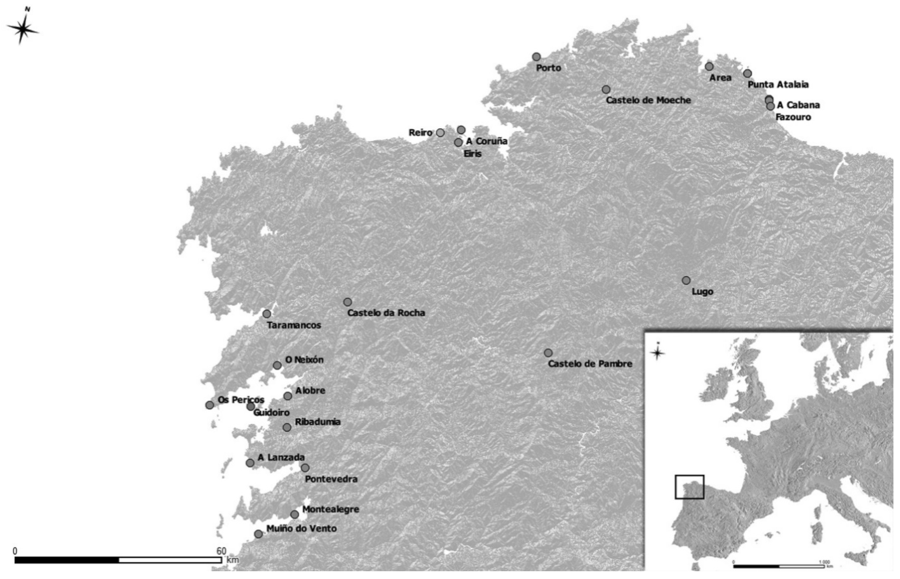
2. Relevance of Midden Deposits in Galicia

The wealth of cultural and biological information that midden deposits yield is noteworthy. This is not the place to summarize the scope of the potential research one can address when a rich midden deposit is excavated, yet what needs be stressed is that coastal middens harbor a substantial fraction of the physical evidences for addressing the origin and development of fishing, shellfishing, and fish trade in Galicia. Losing these middens implies the destruction of a crucial portion of Galicia’s natural and cultural heritage and of evidence that may help us plan for a better management of the coastal environment.
The analyses thus far reveal a generalized cropping of marine resources in coastal Galicia from prehistoric times (Mesolithic) until the second century B.C. At this time, hints of a shift from subsistence (local) to intensive (regional trade) harvesting appear (Bejega-García 2015). That shift was apparently fostered by the Romans, and was marked by a focus on sardines (Sardina pilchardus Walbaum, 1792), oysters (Ostrea edulis Linnaeus, 1758), red-mouthed rock shells (Stramonita haemastoma Linnaeus, 1767), and by the appearance of structures to process them (e.g., salting vats) (González Gómez de Agüero 2014; Bejega-García 2015; Souto et al. 2008). Evidence of large-scale fishing practices re-emerged during Medieval times, when the focus shifted to species such as hake (Merluccius merluccius Linnaeus, 1758) and conger eels (Conger conger Linnaeus, 1758), confirming the data provided by the documentary sources (Ferreira Priegue 1988, 2009). Although the specifics of these developments, (e.g., fishing of sardines not before the Late Iron/early Roman Age, shellfishing yielding to fishing through time (Table 1) etc.), remain for the most part unknown, the two shifts from subsistence to “industrial” harvesting in Galician middens coincide with times when maritime trade expanded in the Northeast Atlantic (Ferreira Priegue 2009).
In view of the scarce number of faunal collections analyzed, the >100 species presently documented on Galician middens may represent but a fraction of the diversity these deposits harbor. Indeed, although vertebrates and large mollusks appear reasonably well documented, no systematic studies have been aimed at groups such as micro-mollusks, crustaceans, or echinoderms, that are frequent items on most assemblages. The same applies to cetacean remains, whose identification very often requires DNA analyses, and corals, given the scarcity of specialists for this group. Solving such limitations would result in the number of taxa rising exponentially, as has been shown for Cantabrian shellmiddens (Gutiérrez-Zugasti et al. 2016).
Faunal analyses can help address a variety of wildlife management and conservation issues. One crucial issue is the overexploitation of commercial fish stocks. Galician middens harbor large amounts of bones from species such as hake, sardines, and conger eels. Learning how each one of these was exploited in the past, pairing zooarchaeological and biomolecular analyses of archaeological fish bones, would help us define baselines for future action. This idea responds to the Hindcasting-first-to-forecast-after approach that enhances perception of a given species’ biology and ecology to improve population management (Morales-Muñiz et al. 2018; L. Llorente et al., work in progress).
Species can often serve as proxies informing about changes in the marine domain (e.g., temperature). In Galician middens, for example, warm water indicators from the late Iron Age and early Imperial Period include chub mackerel (Scomber japonicus Houttuyn, 1782), the clam Eastonia rugosa (Helbling 1779), and the red-mouthed rock shell and red coral (Corallium rubrum Cuvier, 1798). The clam and red coral disappeared from Galician shell middens after Roman times, whereas S. haemastoma did so after the Late Middle Ages, and the two mollusks reappeared in the region during the past decade (Francés et al. 2009).
Discordant distributions of taxa found in coastal middens can also prove useful to track down trade and marine industries such as oyster culture. Oyster culture in northern Iberian coasts one hints at the A.D. VIth–VIIth site of Tabacalera (Gijón, Asturias), where the retrieval of Mediterranean snails that live within oyster beds suggests the translocation of oysters during Roman times (Llorente Rodríguez and Morales Muñiz 2015). Zooarchaeological analyses should determine the origin of Galician oyster culture and help track its expansion throughout the Northeast Atlantic, mapping the finds of oyster bed commensal snails whose biogeographical origin appears confined to the Mediterranean. Trade, in turn, might be inferred through signatures such as cutmarks on bones, fish sizes restricted to a narrow range of values or a systematic absence of certain skeletal portions in coastal middens.

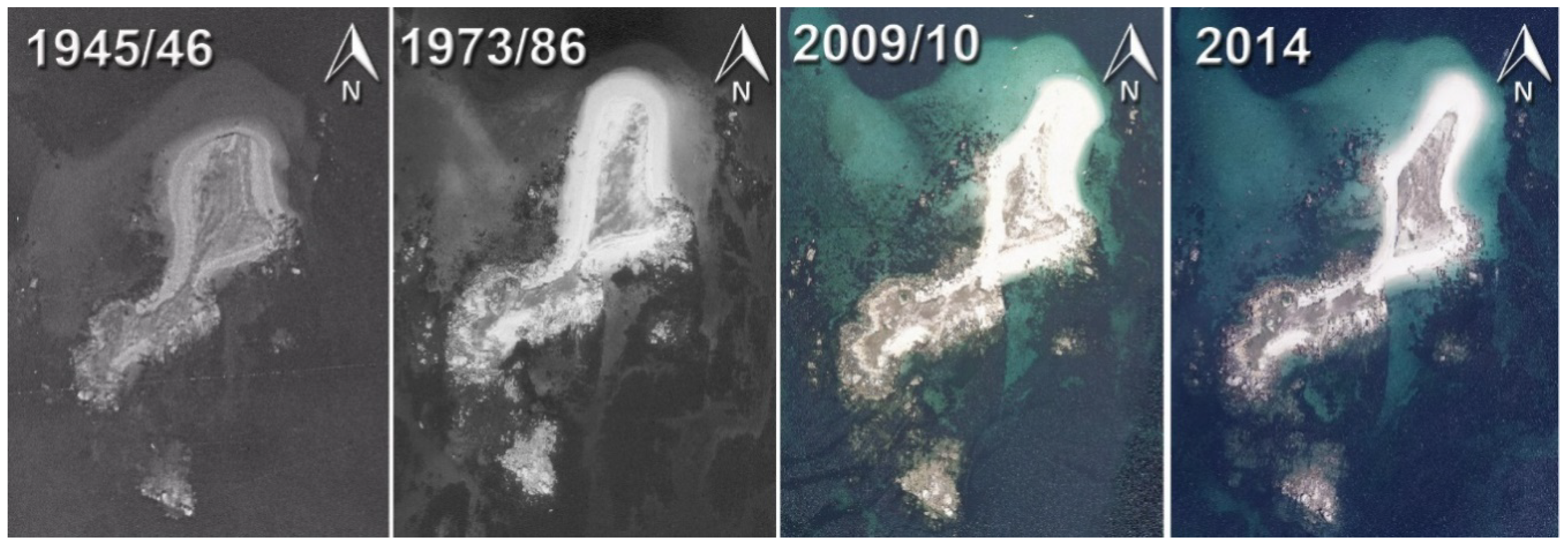
3. Threats to the Galician Coastal Midden Heritage

In the last 10 years, we have studied faunal remains from some 30 shell and fish middens ranging from the Bronze Age to Modern times, and surveyed restricted sectors of the Galician coastline (Fernández Rodríguez et al. 2014a, 2014b, 2015). From these studies and additional records, press releases, and archaeological surveys we estimate that no less than one thousand middens could exist on the Galician coastline (i.e., taking into account the ca. 100 coastal Iron Age and Roman Galician hillforts, a most conservative estimate of three middens per site yields 300 deposits). Add to these offal deposits associated with the >100 Roman and Middle Age coastal fish factories, villae, monasteries, castles, and hamlets, plus the dozens of coastal prehistoric sites presently documented, and those 300 deposits would treble. The 1000 middens estimate roughly coincides with an extrapolation to the 1500 km of Galician coast of data from 40 km surveys on the ría de Arousa coast, where an average of one hillfort per 4 km and three middens per hillfort were recorded (unpublished data).
The 1000 midden figure serves as a coarse estimate to calibrate our present lack of awareness about a heritage people are barely acquainted with. Indeed, even for most of the midden deposits thus far documented, detailed studies of materials are lacking due to a lack of interest on the part of the administrations, a lack of funding, inadequate retrieval, etc. Still, from our standpoint, the largest risk these middens face is the absence of a master plan for their management. This is disturbing news for, even though risks have always existed, coastal midden threats are increasing at such a fast rate that a significant fraction of the deposits may disappear before we even learn about their existence.
There are two major kinds of threats presently menacing the Galician coastal middens, outlined in the following paragraphs.

3.1. Anthropic Agents

Humans have probably been the most prevalent and aggressive agent of destruction of the Galician coastal heritage, their actions being documented as systematic since the 19th century (González Gómez de Agüero 2014; Bejega-García 2015). This destruction involves direct aggressions, such as the construction of dwellings, infrastructures, and industrial complexes, but also indirect ones having to do with landscape changes (e.g., infillings, land reclamation, intensified erosion of agricultural soils).
A case in point is that of the oldest coastal deposit thus far recorded in Galicia, the Mesolithic shell midden from Reiro (Arteixo, La Coruña). Excavated almost a century ago, the site occupied an area of ca. 120 m2 in 1968 when sand mining activities destroyed a large parcel. The site definitively disappeared in 1973 after a parking lot was built over the remaining area (Ramil Soneira 1973). The destruction of Reiro was a terrible loss for the Galician coastal heritage. The site was not only the oldest coastal settlement in Northwest Iberia but also dated from a time when the Flandrian transgression started in earnest and strictly marine fish species penetrated deep into estuarine/brackish waters of the Northeast Atlantic (Pickard and Bonsall 2004). Since the Reiro collections housed at the Museum of San Antón (A Coruña) and the Archaeology and Prehistory Museum from Vilalba (Lugo) incorporate but a minimal fraction of the recorded fish assemblages, we remain ignorant about the nature of fishing at that time, and whether some marine fish species featured local populations adapted to less saline environments.
Although the destruction of the Reiro midden occurred prior to the approval of the 1985 Spanish Heritage law that forbids constructions on the beach, the story has not changed substantially since that time. The so-called “real estate boom” that started around the turn of the millennium sparked an indiscriminate urban development along the Spanish shores, including those from Galicia (González 2005). In a mere two decades, the Galician coastal cultural heritage suffered an unprecedented onslaught in terms of road building, marinas, and housing, that transformed the landscape more profoundly than in the previous 200 years (Marcos et al. 2010). Our surveys documented the construction of beach huts in the ditch of the Galaico–Roman “castro” (hillfort) at Fazouro (Foz, Lugo), the destruction of a LateMiddle Age midden when completing the corniche at Area (Viveiro, Lugo), and the destruction of a LateMedieval fish midden at O Porto (Valdoviño, A Coruña). Particularly damaging have been the road building works around large middens, such as those at Taramancos (Noia, A Coruña) and Montealegre (Moaña, Pontevedra), as well as harbor refurbishing works and apartment building at the site of O Achadizo (Boiro, A Coruña). Initiatives of the Galician Heritage Bureau, such as the building of the Marine Museum of Vigo or forest paths in protected coastal areas, represent isolated initiatives unlikely to reverse such a state of affairs. Even more disturbing is the fact that few people ever express concern over such losses.
Perhaps the most significant case of this urban development is that recorded at Punta Atalaia (San Cibrao, Lugo). This huge midden surfaced in 2006, when works to build an observatory for the marine fauna started, using heavy machinery. The machines had already destroyed half of a 9 m high midden when the operations came to a halt after one neighbor reported it to the local authorities. Thanks to this report, we managed to carry out a rescue excavation in what turned out to be an early Roman (republican) shell midden (Fernández Rodríguez et al. 2008). In the years that ensued urban developers started working on the western sector of that peninsula, where a further 2000 m2 were destroyed. This time the works came to a halt after the Asociación Mariña Patrimonio reported the case to the local authorities, who eventually granted us access to study the materials. Punta Atalaia harbors the largest and richest mollusk and fish collections ever reported in Galicia, featuring early Roman and late imperial levels underlying others from the end of the Middle Ages. Faunal analyses, along with fishing and shellfishing, showed evidence of whaling and a systematic exploitation of red coral. This is the only instance of coral exploitation documented in northern Iberia and testifies to a time when warmer waters occurred in the region (González Gómez de Agüero 2014).
Uncontrolled destruction is not the only problem facing midden deposits in Galicia. Lack of standardized protocols, for example, as well as deficient acquaintance with the most basic sampling and conservation procedures, often result in deficient retrieval and generate collections that are not readily available for study.

3.2. Natural Agents

The second category of agents that are doing away with coastal middens in Galicia are natural phenomena grouped under the all-encompassing label of climatic change (Alonso 2016; Ortí 2016; Gómez-Pazo and Pérez-Alberti 2017). That destruction is mostly the result of the combined action of two interrelated agents:
(a) Sea level rise, with its associated shore erosion, is now uncovering formerly buried middens throughout the Galician shoreline. At both Vigo and A Coruña, the latest estimations set that rise between 2.25 and 2.68 cm/decade, a figure higher than that resulting from any postglacial rebound (Rosón et al. 2009). The problem is more pressing in the case of the rías where the land is subsiding since the Alpine orogeny (contrasting with the Norwegian fjords and Scottish firths, whose land is rebounding after the continental ice sheets disappeared). This problem is also pressing for many islands along the western Galician coast, as most stand barely above sea level. Middens of such relevance as those from Punta Frandiño (island of Cortegada, Pontevedra) and Almacén (island of Sálvora, A Coruña), or those associated with the Roman salting installations on the island of Ons (Pontevedra), come to mind but many others exist (Ballesteros-Arias 2009; Ballesteros-Arias et al. 2013).
The most dramatic case of sea level rise today is that taking place on Guidoiro Areoso, on the municipality term of Vilagarcía de Arousa (Pontevedra) (Rey-García and Vilaseco-Vázquez 2012). This ca. 9 Ha, mostly sandy, islet documents megalithic (i.e., 5th–4th millennia cal. B.P.) graves, along with a settlement from the Bronze Age whose fish middens are gradually eroding due to sea level rise(Blanco-Chao et al. 2015). Between 2008 and 2014 its beaches lost one full meter of sand (Figure 2), even though a series of walls were built to protect the archaeological deposits (A.G. 2014). The loss of these deposits would mean that one of the oldest documented exploitation of mollusks in Northwest Iberia, along with the earliest evidences of fishing in the north Iberian Bronze Age, would vanish forever.
(b) The second significant climate-related agent of destruction is storms. In this case, the paradigm is a new kind known as explosive cyclogenesis—avery fast deepening of an extratropical cyclonic low-pressure area. Explosive cyclogeneses, with winds ranging from 120 to 200 km/h and swells on the shore over 10 m, are a recent development in Galicia that are rapidly and unpredictably destroying middens, such as those discovered in 1996 during works to build the corniche at Area (Viveiro, Lugo) (Bouza 2014). Archaeological surveys in 2007 uncovered structures from a Roman villa and a medieval village (Bejega-García et al. 2011). Since then, the site has remained abandoned and unprotected and has suffered an onslaught of successive cyclogeneses that did away with the Roman salting vats located on the beach (Serantes 2014).
The only instance where we managed to muster some action took place at A Cabana (Barreiros, Lugo). This deposit remained hidden until a heavy storm uncovered and partially destroyed it in March 2015. Thanks to press releases by the Asociación Mariña Patrimonio, we managed to carry out a small rescue excavation. The study revealed one of the very few concentrations of the red-mouthed rock shell documented in Galicia, hinting at an industrial purple-dying activity rarely documented on northern Iberian shores (Fernández Rodríguez et al. 2014b, 2015). At A Cabana, the presence of the warmth-loving red-mouthed rock shell also shows evidence of the higher temperature stage in the Galician sea during Roman times that the red coral at Punta Atalaia revealed.

4. A Long Historical Record of Midden Destruction

The problems we have mentioned thus far are neither new nor isolated cases, as indicated by the destruction of Galicia’s coastal heritage we have been able to trace back to the 19th century, even though the tempo and mode of that destruction presumably took place at far lower levels.
In the 19th century, the interest in archaeology in Galicia developed in connection with the romantic and neoromantic movements, aiming at a reinforcement of the local identity and a search for origins within the Celtic (i.e., Castreña, Iron Age) culture (Acuña Castroviejo 1996; Lourido 1997; Fernández Rodríguez 2000). It is within such currents that midden deposits, often found lying next to Celtic hillforts, gained relevance. This relevance had a social side to it, since middens added a temporal dimension to Galicia’s secular interaction with the sea, so crucial for the economy and identity of the region at all times. It also had a practical side, because acidic soils in Galicia result in few organic remains retrieved outside high pH soils, as are those from shell middens.
The earliest references to middens appear in connection with their destruction, often a result of urban development, road building, etc., and the efforts local scholars made to protect them. This was the case of Manuel Murguía, who reported the shell midden from the hillfort at Vilagarcía de Arousa after a dock building operation destroyed the site. Murguía learned about the midden after a neighbor from this city, Ramón Valle, placed a lawsuit in the local newspaper La Voz de Arousa (Murguía 1888). A few years later, Fernández Gil y Casal (1916) was the one reporting a landslide on the terrace of this same hillfort that destroyed another shell midden. The story of the hillfort from Vilagarcía de Arousa is a paradigm of what has happened to many middens in Galicia, but also of the hope one needs to harbor for the future. Indeed, new excavations presently under way on several shell middens from this site are revealing a wealth of valuable and unsuspected data (C. Fernández, E. González, V. Bejega and N. Fuertes, work in progress). More than a century of unsuccessful trials had to pass before one could study its collections.
Most of the early documented shell middens were not so fortunate. This was the case of those around the Castro da Bouza hillfort (Fernández Gil y Casal 1916), the midden destroyed in 1896 during the construction of the road between A Guardia and El Pasaje (Domínguez Fontela 1925) and those reported in press notes on the “Ideal Gallego” by Esmoris Recamán (1923).
From the beginning of the 20th century, while amateurs kept on reporting lost middens, the first archaeological excavations started on the hillforts. Of these, the one carried out by Ignacio Calvo at Santa Trega (A Guardia, Pontevedra) lasted for a decade (i.e., 1914–1923; Calvo y Sánchez 1914, 1920, 1924). Even though from a methodological standpoint these excavations were state-of-the-art for their time, there was no interest whatsoever in the analysis of organic remains, the references to these being cursory remarks in the excavation reports (Acuña Castroviejo 1996). These middens were at the time wrongly considered Mesolithic, due to the inertia of considering them contemporaneous of the Mesolithic shell middens excavated at the time in Portugal and the Cantabrian coast.

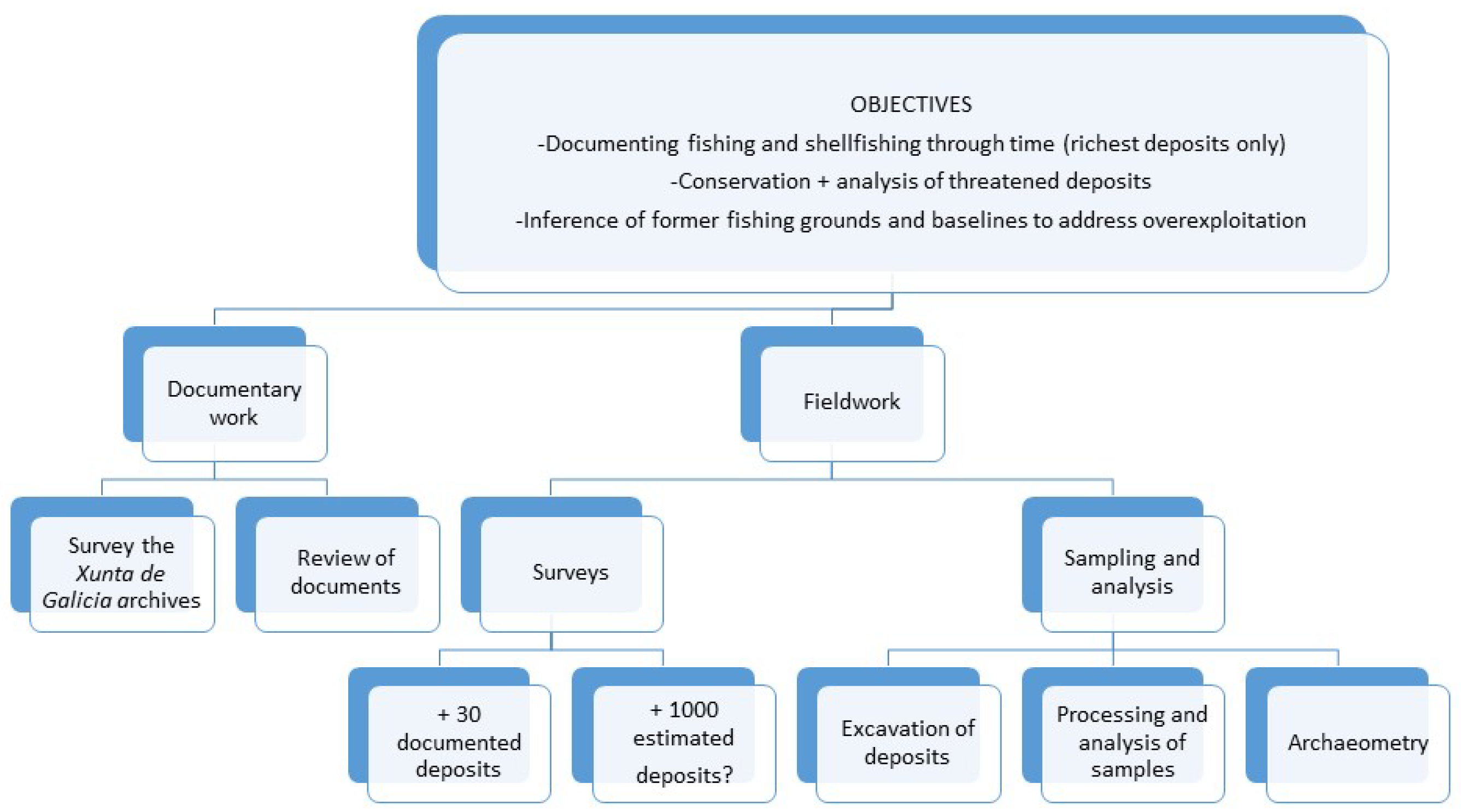
5. A Master Plan for the Future

Many scholars have been warning about the consequences of global warming and climate change for the archaeological heritage and many are concerned with the risks facing coastal and maritime sites. These issues have come to the fore during these past years due to a confluence of factors, including sea level rise, coastal environmental dynamics and human activities (Erlandson 2008; Erlandson and Fitzpatrick 2006).
Some countries have been ahead in terms of preventive management. If our survey of activities were to be restricted to the Northeast Atlantic, Scotland, Wales, and England are certainly the pioneers in this field, framing the issues to address and dictating the course of action since the early 1990s (Ashmore 1994). From the very beginning, these policies were developed and implemented with the help of their respective institutions (e.g., English Heritage 1997) that in the case of England, for example, funded coastal surveys that ultimately could be used to identify zones at risk (i.e., RCZA—Rapid Coastal Zone Assessment). These actions have promoted a substantial number of promising initiatives (Flatman 2009). The Scottish coastal zone surveys are commissioned by Historic Scotland, then carried out by others including charities such as SCAPE TRUST (2019) that have surveyed the Scottish coastline alongside the local authorities and archaeologists since the very start of this century. In contrast with our aims (see below), these surveys are not done by risk, as most aim to cover the entire shoreline systematically, to conduct research and preserve endangered sites while promoting public archaeology.
Other countries within the North Atlantic region are developing their own projects aiming at an evaluation and monitoring of the destructive processes that affect their coastal archaeological heritage. Without the need to be exhaustive, this would be the case of projects such as ALERT (Archéologie, Littoral et Rechauffement Terrestre) centered on the French Atlantic coast (Daire et al. 2012), CARRA (Coastal Archaeological Resources Risk Assessment) in Newfoundland and Labrador (Bell and Robinson 2014–2019), or different risk assessments on U.S. coasts (see Reeder-Myers 2015; Anderson et al. 2017). These initiatives allow the categorizing of sites according to their vulnerability and have led, or eventually will lead, to a call for policy awareness and the development of specific management procedures. These success stories prove the need to increase the degree of involvement of different institutions now that an acceleration of the destructive coastal processes appears to be taking place (e.g., Graham et al. 2017).
Most of the documented coastal heritage in Galicia is either threatened or on the brink of disappearing. Matters are more pressing still since we do not have a precise idea about how many of the total existing sites are represented by our documented sites. We therefore need to take action soon. Up until now, we have been able to document and study more than 20 middens, spanning from the Mesolithic to Modern Age times, that double the number of studies thus far completed by others. In addition to Masters and PhD theses, we published a number of papers and delivered presentations at conferences. In parallel, fully conscious of the instrumental role the local community plays here to raise public awareness, school talks and public lectures were made. Lack of appropriate funding has forced us to rely solely on our personal initiative, money, and time, restricting the impact of our effort.
One previous project by López-Romero and collaborators—eSCOPES(Evolving spaces: coastal landscapes of the Neolithic in the European Land’s Ends)—made the first and only attempt to draw the attention to some variables affecting a few coastal case studies in Galicia (López-Romero et al. 2014, 2015). The project made use of close-range photogrammetry derived from recent historical images from the ría de Arousa, provided by local citizens, organizations, and institutions, to make a first evaluation of archaeological threats. The technique also aimed at serving as an archive in the event of partial or total loss of the archaeological evidence. Despite the unquestionable possibilities close-range photogrammetry offers to prevent the total loss of archaeological information, this effort is restricted to architecture, settlement structures, and anthropic management of the landscape. Biological remains and other material culture evidences fall outside such a ‘safety net’.
Public awareness on the loss of coastal heritage at large and evidences of past marine exploitation in particular, has proved crucial to influencing stakeholders and managers to take action and protect archaeological sites (López-Romero et al. 2017; Guidoiro Dixital 2018). Unfortunately, these actions are often implemented only after great damage has occurred and heritage been lost. Moreover, these actions are, for the most part, restricted to previously known sites, and most of them again focus on architecture.
If things are to change significantly for bioarchaeological heritage in Galicia, a coherent master plan with clear objectives and ways to undertake them will be required in order to request funding. For obvious reasons our focus is on middens and falls into two major areas (Figure 3):
  • Documentary work: One first requirement is to carry out a systematic review of archaeological inventories and interim reports housed in the regional archives of the Dirección Xeral do Patrimonio da Xunta de Galicia (i.e., Galicia’s regional government), as well as documents from medieval, modern, and contemporaneous times in archives of all kinds (including personal libraries). This would allow us to locate key spots linked with the exploitation of the marine realm. The deliverable from this effort should be a detailed and comprehensive map of Galician midden locations to carry out the fieldwork.
  • Simultaneously, we need to provide guidelines to the administration to ensure, on the one hand, a prompt response once sites are located, as well as appropriate ways to excavate, curate, transport, and eventually study midden materials.
  • Fieldwork: This part will require an intensive survey of the Galician littoral, perhaps the most urgent aspect of our proposal at this moment. Previous gathering of data from the local inhabitants would be necessary. Surveys should not just provide lists of sites for any given region but also set up a priority list of actions for each site. To this end, it would be necessary to generate a unitary scale where the threats faced by each deposit, including coastal exposition, size, and the specific kinds of anthropic and natural risks, could integrate into a specific value set within a previously defined scale. Given that survey teams would be required to work for days on transects of several kilometers, a substantial task of the master plan implies training programs before people can set off for the field.
Only after surveying is completed, which could take years depending on the budget, people involved, etc., could the excavation and analysis of deposits start. The aforementioned priority list should thus specify whether a particular midden should be excavated partially or totally, how the excavation should proceed, what retrieval methods would yield better results. Unforeseen circumstances might determine the priority list, rescue operations might end up being more important than systematic ones. Only after the materials have been retrieved and stored would it be feasible to decide when and what to study. This, one must stress, is a secondary item on our agenda. Indeed, deposits can be left undisturbed in cases where they do not face any risks. Once safely stored and curated, deciding what and when to study should not be so pressing an issue.

6. Conclusions

Although many considerations in this paper, in particular those dealing with the master plan, are of a more theoretical and descriptive nature than a practical one, there is a practical side to our proposal in that it that derives from years of surveying, excavating, and analyzing data. During that time, we have witnessed the importance that mustering the interest of the administrations and the local communities holds for achieving success. We are now in a position to inform and help the local and regional governments on the need to take measures to protect this heritage. Often, we also know what those measures should be and even how one should go about implementing them, although here a healthy dose of interchange with other scholars would be welcome. Switching from theory to praxis would also require help of various kinds. Funding is obviously crucial and, as stated, this project might prove in the end too ambitious a development, even when taken at the local level. Still, what we now feel is our most urgent need is information. This would include feedback with other groups doing equivalent things, information on how to link with them and with scholars interested in the subject. It is such foreseeable networking what would grant our project a more encompassing scope and a more appealing nature. We hope that these lines will serve as the first step in a quest to find partners to help us crystallize ideas into actual developments.

Author Contributions

Conceptualization, A.M.-M., E.G.-G.d.A. and C.F.-R; Methodology, E.G.-G.d.A., V.B.-G. and C.F.-R.; Writing-Original Draft Preparation, A.M.-M., E.G.-G.d.A., V.B.-G, C.F.-R., E.R.-I., L.L.-R., N.F.-P.; Writing-Review & Editing, A.M.-M., L.L.-R., E.G.-G.d.A., C.F-R.

Funding

This research benefited from Grants HAR 2014-55722-P (“Ictioarqueologia de la Prehistoria cantábrica: Modelos para la caracterización de las primeras pesquerías europeas”), HAR 2017-88325-P (“Historical archaeobiology of the European hake (Merluccius merluccius, L.1758) in the NE Atlantic: The Iberian evidence (AD 10th-18th”) from the Spanish Ministerio de Economía y Competitividad and Grant 19438/PI/14 (“Proyecto Gavilanes: Explotación de recursos naturales en el litoral de Mazarrón (Sureste Ibérico) de fines del III milenio a.C. al cambio de Era. Formas, modelos de explotación y derivaciones paleoecológicas”) from the PROGRAMA SÉNECA 2014. L. Llorente was supported by the European Commission under a Marie-Curie-Sklodowska-If fellowship for Career development FISHARC-IF 658022.

Acknowledgments

We thank the organizers of the 2016 Oceans Past Platform Conference Bayscapes: Shaping the Coastal Interface through Time for granting us the chance to contribute to this volume and also the four anonymous reviewers whose constructive proposals helped us in producing a more balanced manuscript.

Conflicts of Interest

The authors declare no conflict of interest.

References

  1. A.G. El mar, principal amenaza de las mámoas de Areoso. Faro de Vigo, June 28.
  2. Acuña Castroviejo, Fernando. 1996. Historiografía e investigación de la Cultura Castrexa en Galicia. In A Cultura Castrexa Galega a Debate. Edition Coordinated by José Manuel Hidalgo Cuñarro. Tui: Instituto de Estudios Tudenses, pp. 25–39. [Google Scholar]
  3. Alonso, José. 2016. Los temporales causan estragos en yacimientos arqueológicos costeros de Barreiros y Ribadeo. La Voz de Galicia, February 23. [Google Scholar]
  4. Anderson, David G., Thaddeus G. Bissett, Stephen J. Yerka, Joshua J. Wells, Eric C. Kansa, Sarah W. Kansa, Kelsey Noack Myers, R. Carl DeMuth, and Devin A. White. 2017. Sea-level rise and archaeological site destruction: An example from the southeastern United States using DINAA (Digital Index of North American Archaeology). PLoS ONE 12: e0188142. [Google Scholar] [CrossRef] [PubMed]
  5. Ashmore, Patrick. 1994. Archaeology and the Coastal Erosion Zone: Toward a Historic Scotland Policy. Edinburgh: Historic Scotland. [Google Scholar]
  6. Ballesteros-Arias, Paula. 2009. O Aproveitamento do mar a o longo do tempo, a documentación do xacemento romano de Canexol (Illa de Ons, Bueu). Cuadernos de Estudios Gallegos 56: 67–90. [Google Scholar] [CrossRef]
  7. Ballesteros-Arias, Paula, Alejandro Güimil-Fariña, and Elías López-Romero. 2013. Estudio arqueolóxico do Parque Nacional Marítimo-Terrestre das Illas Atlánticas de Galicia. Prospección superficial e vulnerabilidade. Capa 33, Cuadernos de Arqueoloxía e Patrimonio. Madrid: CSIC-INCIPIT. [Google Scholar]
  8. Bejeja-García, Víctor. 2015. El marisqueo en el noroeste de la Península Ibérica durante la Edad del Hierro y la Época Romana. Ph.D. Thesis, Universidad de León, León, Spain. [Google Scholar]
  9. Bejega-García, Víctor, Eduardo González Gómez de Agüero, and Carlos Fernández Rodríguez. 2011. Pesca y marisqueo en el yacimiento de Area (Viveiro, Lugo). Férvedes 7: 255–63. [Google Scholar]
  10. Bell, Trevor, and Christina Robinson. 2014–2019. CARRA Coastal Archaeological Resources Risk Assesment. Available online: https://carra-nl.com/ (accessed on 12 February 2019).
  11. Blanco-Chao, Ramón, Manuela Costa-Casais, José Manuel Rey-García, and Xosé Ignacio Vilaseco Vázquez. 2015. Erosión costera en yacimientos arqueológicos: Guidoiro Areoso, Ría de Arousa, Galicia. Geo-Temas 15: 1–4. [Google Scholar]
  12. Bouza, Luis Felipe. 2014. Los temporales destapan en el litoral nuevos restos arqueológicos. El Progreso, March 20. [Google Scholar]
  13. Calvo y Sánchez, Ignacio. 1914. Exploraciones arqueológicas. Citanias gallegas. Revista de Archivos, Bibliotecas y Museos XXXI: 1–15. [Google Scholar]
  14. Calvo y Sánchez, Ignacio. 1920. Monte de Santa Tecla. La Guardia (Pontevedra). Exploraciones arqueológicas verificadas en los años 1914 a 1920. Vigo: Revista de Archivos, Bibliotecas y Museos. [Google Scholar]
  15. Calvo y Sánchez, Ignacio. 1924. Monte de Santa Tecla en Galicia. Memoria de los trabajos realizados en 1922–23. Memoria no. 62. Edición especial de la “Sociedad Pro-Monte”. La Guardia: Junta Superior de Excavaciones y Antigüedades. [Google Scholar]
  16. Daire, Marie-Yvane, Elias Lopez-Romero, Jean-Noël Proust, Hervé Regnauld, Soazig Pian, and Benheng Shi. 2012. Coastal Changes and Cultural Heritage (1): Assessment of the Vulnerability of the Coastal Heritage in Western France. The Journal of Island and Coastal Archaeology 7: 168–82. [Google Scholar] [CrossRef]
  17. Domínguez Fontela, Juan. 1925. La estación paleolítica de La Guardia. Boletín Arqueológico de la Comisión Provincial de Monumentos Históricos y Artísticos de Orense 160: 241–44. [Google Scholar]
  18. English Heritage. 1997. England’s Coastal Heritage: A Statement on the Management of Coastal Archaeology. London: English Heritage. [Google Scholar]
  19. Erlandson, Jon M. 2008. Racing a rising tide: Global warming, rising seas and the erosion of Human History. Journal of Island and Coastal Archaeology 3: 167–69. [Google Scholar] [CrossRef]
  20. Erlandson, Jon M., and Scott M. Fitzpatrick. 2006. Oceans, islands, and coasts: Current perspectives on the role of the sea in human prehistory. Journal of Island & Coastal Archaeology 1: 5–32. [Google Scholar]
  21. Esmoris Recamán, Francisco. 1923. Recuerdos históricos de la villa de Finisterre. El Ideal Gallego, November 8. [Google Scholar]
  22. Fernández Gil y Casal, Juan. 1916. Apuntes arqueológicos. Boletín de la Academia de la Historia LXVIII: 29–46. [Google Scholar]
  23. Fernández Macho, Javier, Carmen Gallastegui Zulaica, and Pilar Gonzalez Casimiro. 2006. Medición de impactos económicos a partir de una matriz de contabilidad social: El sector pesquero en Galicia. Revista Española de Estudios Agrosociales y Pesqueros 212: 41–79. [Google Scholar]
  24. Fernández Rodríguez, Carlos. 2000. Los macromamíferos en los yacimientos arqueológicos del Noroeste peninsular: Un estudio económico. Ph.D. Thesis, Tesis Doctorales de la Universidad de Santiago de Compostela, Edición en cd-rom. Universidade de Santiago de Compostela, Santiago de Compostela, Spain. [Google Scholar]
  25. Fernández Rodríguez, Carlos, Eduardo González Gómez de Agüero, and Víctor Bejega García. 2008. Estudio del conchero del Castro de Punta Atalaia (San Cibrao, Lugo). Férvedes 5: 43–52. [Google Scholar]
  26. Fernández Rodríguez, Carlos, Víctor Bejega García, and Eduardo González Gómez de Agüero. 2014a. Shellfish gathering during the Iron Age and Roman Times in the northwest of the Iberian Peninsula. In Archaeomalacology: Shells in the Archaeological Record. Edited by Katherine Szabó, Catherine Dupong, Vesna Dimitrijević, Luis Gómez Gastélum and Nathalie Serrand. BAR International Series 2666; Oxford: Archaeopress, pp. 135–45. ISBN 978-1-40-731308-5. [Google Scholar]
  27. Fernández Rodríguez, Carlos, Víctor Bejega García, Eduardo González Gómez de Agüero, and Natividad Fuertes Prieto. 2014b. Púrpuras del Finisterre: El registro de murícidos en época romana en el noroeste peninsular. In Moluscos y púrpura en contextos arqueológicos atlántico-mediterráneos. Nuevos datos y reflexiones en clave de proceso históico. Edited by Juan Jesús Cantillo Darío Bernal and José Ramos. Cádiz: Actas Historia y Arte, Universidad de Cádiz, pp. 319–28. ISBN 978-8-49-828475-1. [Google Scholar]
  28. Fernández Rodríguez, Carlos, María Natividad Fuertes Prieto, Eduardo Ramil Rego, Víctor Bejega García, and Eduardo González Gómez de Agüero. 2015. A Cabana (Barreiros, Lugo): Primeros datos de un conchero purpurino en la costa cantábrica. Férvedes 8: 85–94. [Google Scholar]
  29. Ferreira Priegue, Elisa María. 1988. Galicia en el comercio marítimo medieval. Ph.D. Thesis, Universidad de Santiago de Compostela, Santiago de Compostela, Spain. [Google Scholar]
  30. Ferreira Priegue, Elisa María. 2009. Pesca y economía regional en Galicia. In La pesca en la Edad Media. Edited by Sociedad Española de Estudios Medievales. Madrid: Monografías de la Sociedad Española de Estudios Medievales, Volume 1, pp. 145–66. [Google Scholar]
  31. Flatman, Joe. 2009. A climate of fear: Recent British policy and management of coastal heritage. Public Archaeology 8: 3–19. [Google Scholar] [CrossRef]
  32. Francés, Guillermo, Irene Alejo, Patricia Bernárdez, Paula Diz, Raquel González Álvarez, Joan Grimalt, Angel Mena, Miguel Angel Nombela, Leopoldo Pena, Marta Pérez Arlucea, and et al. 2009. Marco climático mariño de Galicia na era preindustrial: Variabilidade climática natural a escala milenaria e submilenaria. In Evidencias e impactos do cambio climático en Galicia. Edited by Vicente Pérez Muñuzuri, Marisa Fernández Cañamero and José Luis Gómez Gesteira. Vigo: Xunta de Galicia, Consellería de Medio Ambiente e Desenvolvemento Sostible, pp. 249–70. [Google Scholar]
  33. Gómez-Pazo, Alejandro, and Augusto Pérez-Alberti. 2017. Vulnerabilidad de las costas de Galicia ante los temporales marinos en el contexto del cambio global. Sémata, Ciencias Sociais e Humanidades 29: 117–42. [Google Scholar]
  34. González, Pablo. 2005. La superficie construida en la costa gallega supera la media Española. La Voz de Galicia, November 5. [Google Scholar]
  35. González Gómez de Agüero, Eduardo. 2014. La ictiofauna de los yacimientos arqueológicos del noroeste de la Península Ibérica. León: Área de Publicaciones de la Universidad de León, Serie Tesis Doctorales; 431p, ISBN 978-84-97-73688-6. [Google Scholar]
  36. Graham, Ellie, Joanna Hambly, and Tom Dawson. 2017. Learning from Loss: Eroding Coastal Heritage in Scotland. Humanities 6: 87. [Google Scholar] [CrossRef]
  37. Guidoiro Dixital. 2018. Guidoiro Areoso: Erosión litoral e arqueoloxía. Available online: https://guidoirodixital.wordpress.com/ (accessed on 3 March 2018).
  38. Gutiérrez-Zugasti, Igor, Emma Tong, Asier García-Escárzaga, David Cuenca-Solana, Geoffrey N. Bailey, and Manuel R. González-Morales. 2016. Collection and consumption of echinoderms and crustaceans at the Mesolithic shell midden site of El Mazo (northern Iberia): Opportunistic behaviour or a social strategy? Quaternary International 407: 118–30. [Google Scholar] [CrossRef]
  39. Instituto Geográfico Nacional. 2004–2018. Fototeca Nacional, Plan Nacional de Ortofotografía Aérea (PNOA). Data Retrieved September 2017. Available online: http://pnoa.ign.es/ (accessed on 15 March 2018).
  40. Llorente Rodríguez, Laura, and Arturo Morales Muñiz. 2015. Los moluscos del pozo-depósito de Tabacalera. In La Fábrica de Tabacos de Gijón. Arqueología e Historia de un espacio milenario. Edited by Carmen Fernández Ochoa, Almudena Orejas Saco del Valle, Paloma García Díaz and Fernando Gil Sendino. Gijón: Ayuntamiento de Gijón, pp. 260–65. ISBN 978-8-48-946671-5. [Google Scholar]
  41. López-Romero, Elías, Patricia Mañana-Borrazás, Marie-Yvane Daire, and Alejandro Güimil-Fariña. 2014. The eSCOPES Project: preservation by record and monitoring at-risk coastal archaeological sites on the European Atlantic façade. Antiquity, Project Gallery 88: 339. [Google Scholar]
  42. López-Romero, Elías, María Pilar Prieto Martínez, Alejandro Güimil-Fariña, Jose Manuel Rey García, Patricia Mañana-Borrazás, X. Ignacio Vilaseco Vázquez, and Carlos Otero Vilariño. 2015. Ocupación humana y monumentalidad durante la Prehistoria Reciente en el islote de Guidoiro Areoso (Ría de Arousa, Pontevedra). Investigaciones en el marco de las dinámicas litorales atlánticas actuales. Trabajos de Prehistoria 72: 353–71. [Google Scholar] [CrossRef]
  43. López-Romero, Elías, Xosé Ignacio Vilaseco Vázquez, Patricia Mañana Borrazas, and Alejandro Güimil Fariña. 2017. Recovering information from eroding and destroyed coastal archaeological sites: A crowdsourcing initiative in Northwest Iberia. In Public Archaeology and Climate Change. Edited by Tom Dawson, Courtney Nimura, EliasLópez-Romero and Marie-Yvane Daire. Oxford and Philadelphia: Oxbow Books, pp. 72–80. ISBN 978-1-78-570705-6. [Google Scholar]
  44. Lorenzo, Francisco, Angela Alonso, and José Luis Pagés. 2003. Evolución y erosión comparada de tres sistemas playa/flecha en las Rías de Ortigueira, O Barquero y Viveiro (Galicia, España). Revista Cuaternario y Geomorfología 17: 75–89. [Google Scholar]
  45. Lourido, Francisco Calo. 1997. A Cultura Castrexa. Historia de Galicia 3, 2nd ed. Vigo: Edicións A Nosa Terra, ISBN 978-8-489-13871-1. [Google Scholar]
  46. Marcos, Pilar, Sara del Río, and Julio Barea. 2010. Destrucción a toda costa 2010. Informe de Greenpeace sobre la situación del litoral español. Greenpeace España. Available online: http://www.greenpeace.org/espana/Global/espana/report/other/100709-04.pdf (accessed on 4 March 2018).
  47. Morales-Muñiz, Arturo, Eduardo González-Gómez de Agüero, Carlos Fernández-Rodríguez, Fran Saborido Rey, Laura Llorente-Rodriguez, Begoña López-Arias, and Eufrasia Roselló-Izquierdo. 2018. Hindcasting to forecast. An archaeobiological approach to the European hake (Merluccius merluccius, Linnaeus 1758) fishery: Iberia and beyond. Regional Studies in Marine Science 21: 21–29. [Google Scholar] [CrossRef]
  48. Murguía, Manuel. 1888. Galicia. Barcelona: Daniel Cortezo. [Google Scholar]
  49. Ortí, Antonio. 2016. Las grandes olas aumentan de tamaño. Faro de Vigo, August 13. [Google Scholar]
  50. Pagés Valcarlos, José Luis. 2000. Origen y evolución geomorfológica de las Rías Atlánticas de Galicia. Revista de la Sociedad Geológica de España 13: 393–403. [Google Scholar]
  51. Pickard, Catriona, and Clive Bonsall. 2004. Deep-sea fishing in the European Mesolithic: Fact or fiction? European Journal of Archaeology 7: 273–90. [Google Scholar] [CrossRef]
  52. Ramil Soneira, José María. 1973. Paradero de Reiro. Cuadernos de Estudios Gallegos XXVIII: 23–31. [Google Scholar]
  53. Reeder-Myers, Leslie A. 2015. Cultural Heritage at Risk in the Twenty-First Century: A Vulnerability Assessment of Coastal Archaeological Sites in the United States. The Journal of Island and Coastal Archaeology 10: 436–45. [Google Scholar] [CrossRef]
  54. Rey-García, José Manuel, and Xosé Ignacio Vilaseco-Vázquez. 2012. Guidoiro Areoso. Megalithic cemetery and prehistoric settlement in the Ría de Arousa (Galicia, NW Spain). In Environmental Changes and Human Interaction along the Western Atlantic Edge. Edited by António Campar Almeida, Ana Maria dos Santos Bettencourt, Delminda Moura, Sérgio Monteiro-Rodrígues and María Isabel Caetano Alves. Coimbra: APEQ, CITCEM, CEGOT, CGUP, CCT, pp. 243–58. ISBN 978-9-89-971401-4. [Google Scholar]
  55. Rosón, Gabriel, José Manuel Cabanas, Fiz Fernández Pérez, José Luis Herrera, Manuel Ruiz-Villarreal, Carmen González Castro, Silvia Piedracoba, and Xosé Antón Álvarez-Salgado. 2009. Evidencias do cambio climático na hidrografía e a dinámica das rías e da plataforma galega. In Evidencias e impactos do cambio climático en Galicia. La Coruña: Xunta de Galicia, pp. 287–302. ISBN 978-8-44-53472-9. [Google Scholar]
  56. SCAPE TRUST. 2019 Scotland’s Coastal Heritage at Risk. Available online: http://www.scapetrust.org/ (accessed on 17 April 2019).
  57. Serantes, Salvador. 2014. Los temporales descubren más restos arqueológicos en Area. Viveiro. La Voz de Galicia, February 11. [Google Scholar]
  58. Souto, Javier, Vicente Lustres-Pérez, and Eugenio Fernández-Pulpeiro. 2008. Nuevos datos sobre la presencia del Molusco Gasterópodo Stramonita haemastoma (Linnaeus, 1766) en las costas gallegas. Nova Acta Científica Compostelana (Bioloxía) 17: 97–104. [Google Scholar]
Figure 1. Location of Galicia within the Iberian Peninsula with indication of the coastal (i.e., marine and fluvial) middens our group studied over the past two decades.
Humanities 08 00085 g001
Figure 2. Aerial photographs from the island of Guidoiro Areoso, (1945–2014). Starting in the 1980s, sea level rise reduced the height of the dune on the northern portion by 1 m in height and has narrowed the beaches to the point that the island will soon split into two (Images taken from the Fototeca Digital del Instituto Geográfico Nacional IGN (2004–2018) under CC-BY 4.0 license. The second image from the left corresponds to a composite of theInterministerial flights taking place between November 1976 and July 1986).
Humanities 08 00085 g002
Figure 3. Flow chart of a working proposal for future action: The Middens’ Master plan.
Humanities 08 00085 g003
Table 1. Galician coastal middens: contribution through time of fish and shell remains in the largest faunal collections. Mean values of fish remains’ contributions rise from 4% in the Iron Age, to 28% in Roman times and 71% during Medieval times. More data are required to confirm whether this emphasis from mollusk to fish reflects a real change in the economy or taphonomical constraints having to do with fish bones being less robust than shells (unpublished data).
PERIOD MontealegreA LanzadaMuiño do VentoO Achadizo
IRON AGENISP703546685741324
% FISH2%6.5%12%5.5%
Punta AtalaiaA CabanaAdro VelloBrigantium
ROMANNISP15,93111762013224
% FISH16.5%1.7%100%32%
Punta AtalaiaAreaTaramancosCastelo da Rocha
MEDIEVALNISP1198251414101075
% FISH84.5%74%37%94.5%

