1. Introduction
Islands and island communities are at the frontline of climate change, as they have lived with its effects for years and have become sites for innovative adaptation strategies and solutions (
Foley 2017). Although diverse, islands often share characteristics, such as smallness (e.g., in size and population) and physical isolation, that influence all aspects of society. These island characteristics make up what is described as
islandness—a term that addresses the distinct but varied conditions and qualities that shape island life (
Foley et al. 2023;
Baldacchino 2004;
Royle and Brinklow 2018). Islandness intersects with the effects of climate change, creating a pressing need for integrated context-specific responses. However, islandness does not only highlight vulnerabilities but also the significant capacities and resourcefulness of island communities, including in responding to crises and facilitating green transitions (
Foley 2017;
Lazrus 2012). The focus on islands and islandness is therefore a lens from which to understand the contextual realities and environmental subjectivities that intersect with green transitions and climate adaptation of a specific island location. At the same time, it provides analytical value and insights to better understand the conditions and mechanisms that interfere with green transitions on a local scale which can inform non-island locations.
Although the concept of islandness is widely recognised and used across disciplines to understand island life, there is limited methodological discussion on the data, tools, or frameworks used to work with it analytically. There is therefore a gap between the application of the concept and its methodological development. Furthermore, especially small islands have limited availability and accessibility of standardised data (
Agius 2022). In this paper, we argue that spatial microsimulation is a suitable scalable and transferable methodological approach that is capable of meeting the limits of available local data, while also being sensitive to the analytical needs of islandness to attend to local differences and variations. Consequently, the aim of this paper is to explore the potential of spatial microsimulation for generating synthetic social survey microdata that can be used to contribute to a better understanding of islandness using the case of green citizenship in Iceland as a demonstrative example. More specifically, we introduce the spatial microsimulation tool
SimIceland and apply it to examine climate change and environmental attitudes in Iceland. We ask the following question:
what is the potential of spatial microsimulation for understanding islandness, with a particular focus on green citizenship? To answer this question, we conduct a simple analysis to demonstrate the methodological and analytical potential of this approach and invite further exploration and development. Iceland offers a unique case for exploring variations in environmental attitudes. The country is characterised by a small population with strong civic institutions, an export-oriented economy that largely operates in a post-carbon energy system, and fragile island ecosystems in a sub-arctic climate. This provides the opportunity for a case study that contributes both to comparative island studies as well as European (and other) decarbonisation debates, offering transferable insights into governance and public-acceptance dynamics. This paper draws on work from the Horizon 2020 EU-funded project PHOENIX: The Rise of Citizens’ Voices for a Greener Europe, which is a project that aims to increase the transformative potential of Democratic Innovations (DIs) by conducting in-depth analysis of evidence-based best-practices (e.g., supporting citizen assemblies, public debates, conferences, and public budgeting) for DIs in 11 pilots across 7 EU countries (
https://phoenix-horizon.eu). The PHOENIX research outputs include an elaboration of a set of methodologies and tools that can be adaptable to different contexts with their specificities, to different institutions’ scales of process, and to address different topics of the European Green Deal (EGD) transition pathway.
In this study, the SimIceland tool is applied to simulate and map citizens’ attitudes towards climate change in Iceland. The tool attempts to estimate and capture geographical distributions of climate change attitudes at local levels. Of particular relevance to the work presented in this paper is recent work focusing on energy-consumption related behaviours (
Seiferth et al. 2024) to better understand individual differences and influences in the shaping of climate change attitudes. We find that this spatial microsimulation tool can bring forward place-specific social, economic, and environmental realities of communities on a local and micro-scale. This has the potential to both deepen our understanding of the local context that is crucial for successful sustainability initiatives, as well as serve as the foundation for public participatory engagement. These are insights and developments that are highly relevant for work on islandness as well as green transitions. We conclude with a call for further developments and applications of the model which is underpinned by an open-source code approach.
This paper is structured as follows: In the next section, Islandness, Green Citizenship, and the Potential of Spatial Microsimulation, we elaborate on how the context of islandness can deepen our understanding of the complexities of climate change governance, the current limits of the engagement with islandness, and the productive potential of spatial microsimulation in addressing this. This is then followed by the Data and Methods Section in which we elaborate on the tool, the data, and the methods. The SimIceland Models and Results Section presents some of the spatial microsimulation model outputs that highlight the relevance and usability of the tool. The Conclusion and Discussion Section outlines further policy implications and recommendations for future applications of the tool.
2. Islandness, Green Citizenship, and the Potential of Spatial Microsimulation
Islandness offers an important lens to understand the challenges and possibilities of green citizenship. Island communities, policy makers, and stakeholders have long argued that sustainability and climate change adaptation measures imported from elsewhere are not fitting to their island realities. Consequently, how and by whom such initiatives are made and carried out on islands is frequently discussed (
Foley 2017;
Leveque 2020). Here, it is important to address how islandness intersects with governance, which shapes small polities and often unique jurisdictional arrangements that create complex relationships among political, private, local, and external interests and actors (
Stoddart et al. 2024). At the local level, this can create a political culture of personalism, where the boundaries between the public, private, and informal spheres get blurred (
Leveque 2020;
Stoddart et al. 2024). High levels of familiarity between islanders and local governance may increase efficiency in policy implementation, but they also intensify internal conflicts and discontent (
Russell et al. 2021). On relations beyond the island, communities often hold great distrust and scepticism towards external influence due to historical colonial ties and conflicts (
Connell 2023). At the same time, (small) islands also often rely on external partnerships and collaboration for sustainability projects due to their limited local capacities (
Stoddart et al. 2024). As climate pressures intensify and outside interests in islands grow, this tension is found to reinforce local distrust in global and externally driven agendas (
Connell 2023).
Studies on successful sustainable initiatives and transitions on islands repeatedly emphasise the critical role of local engagement. Successful initiatives have integrated both the social, economic, and environmental dimension of sustainability to address the multifaceted impact climate change has on island communities (
Connell 2023). Lessons from islands responding to the COVID-19 pandemic emphasise how crises can induce context-specific adaptations and solutions, underscoring that environmental and climate change adaptation cannot be met with a single best practice (
Foley et al. 2022). Instead, understanding what sustainability means in each local setting is critical and helps centre local communities in the decision-making process (
Polido et al. 2014). For example, the transition to renewable energy in the Danish island of Samsø is an initiative where local responsibility, place-based knowledge and identity, and a sense of community has been integral to the process. Here, community involvement and democratic engagement alongside external support and expertise have been at the core of the successful transition (
Sperling 2017). Hence, islands are valuable cases showing that inclusive climate governance building on collaborative problem-solving, broad community participation, and integrated strategies are critical for successful place-based sustainable innovation (
Mirkova and Padrón-Fumero 2025;
Seiferth et al. 2024;
Nurhasanah et al. 2024).
These insights highlight how climate change and the green transition intersect with a complex web of place-specific realities, dynamics, interests, and social attitudes. Therefore, islands cannot be addressed as homogenous entities when formulating climate strategies and policies (
Connell 2023). Islandness is inherently place-bound and will differ from one island to the next as well as internally, which demands a comprehensive understanding of local context and dynamics through a deep engagement with place. Even within a small island, micro-level differences in circumstances and attitudes can impact the success of sustainability initiatives, which highlights the need for locally meaningful engagement (
Royle and Brinklow 2018). Furthermore, islanders’ scepticism of outside agendas underscores the necessity of bottom–up strategies that integrate community knowledge and realities instead of solutions made elsewhere.
While the concept of islandness has been used productively to understand lived experiences of island life, including in the context of climate change adaptation as explained above, it can be argued that it remains underdeveloped in terms of methodological engagement and is in need of more plural analytical approaches (
Foley et al. 2023). Research that engages with islandness tends to be qualitative, and there have been limited efforts to date to quantitatively capture local dynamics; lived experience; and the varying characteristics of islands, such as smallness and isolation. These characteristics are not fixed and are experienced differently across and within island communities. For instance, the sense of isolation may differ between residents of the same island, as islandness does not assume homogeneity in how physical features are felt and understood (
Foley et al. 2023;
Royle and Brinklow 2018;
Agius 2022). However, the lack of diversity in methods risks narrowing what can be known about island societies and limits the ability of research to inform policy, planning, and environmental governance in meaningful ways. Furthermore, island research is also impacted by methodological challenges, including insider–outsider dynamics; local scepticism towards top–down approaches; and research fatigue in small populations, where communities are often repeatedly studied. Data availability is another constraint, with datasets often fragmented, outdated, or inaccessible, where public data are typically aggregated at regional or national levels (
Agius 2022). These issues make it difficult to develop inclusive, responsive, and spatially sensitive quantitative social science approaches to studying islandness and call for the need for transferable, scalable frameworks that can support both research and community engagement.
Given the limitations and challenges pertaining to paucity of data at small-area levels and for island regions (especially smaller island regions) as well as the geographical features of islands and islandness, social simulation methods can be particularly suitable and useful to fill in data gaps and offer analytical power and insights. Social simulation has a long history in the social sciences and, in particular, in urban and regional studies in the context of wider discussions around computer modelling of complexity in socio-spatial systems. The most prominent approaches in social simulation include a method known as spatial microsimulation, which can be used to estimate missing data as well as simulate social phenomena. In particular, spatial microsimulation is a method that typically involves the creation of a synthetic population for areas, which includes estimated information for variables that are not available from published sources, and which can typically be used to inform social and area-based policies (
Ballas et al. 2005;
Tanton 2014;
O’Donoghue et al. 2014;
Lovelace and Dumont 2017).
Adding spatial details to traditional microsimulation involves creating geographically referenced microdata that refer to a particular locality. Since there are very few sources of geographically detailed population microdata, there is a need to create these data using spatial microsimulation techniques by merging census and social survey data to simulate a population of individuals within households (for different geographical units) whose characteristics are as close to the real population as it is possible to estimate. Spatial microsimulation techniques aim to achieve precisely that. Spatial microsimulation techniques involve the merging of survey data with census geographical area data to simulate a population of individuals within households (for different geographical units) whose characteristics are as close to the real population as it is possible to estimate. In other words, geographical microsimulation models simulate virtual populations in given geographical areas, so that the characteristics of these populations are as close as possible to their “real world” counterparts (
Ballas et al. 2005). Given the issues pertaining to lack of social surveys and similar data sets in islands, spatial microsimulation offers a potential solution to address such data paucity. Also, given the geography of islands and the presence of a physical border that is not just administrative, islands can be particularly suitable for the testing of social simulation methods.
3. Case Study: Iceland
Iceland continues to experience comprehensive environmental changes. Ever since human settlement, the Icelandic highlands have been challenged by large-scale deforestation and ecological degradation. This pressure on the fragile ecosystem has increased even further with more intensive use of the mostly uninhabited interior of the island. The Icelandic highlands have been put under direct governmental administration as public lands (
Forsætisráðuneytið Þjóðlendur 2025), and citizens are thereby called to take part in policy making on sustainable land use (
Stoddart et al. 2024;
Arnalds 2019). The public lands are traditionally “commons” in Iceland and have, at least since the 19th century, been used as summer grazing areas for sheep. With time however the use of the highlands has become more diverse and complex. Large-scale sheep farming is not seen as sustainable anymore, and concerns about how summer grazing may endanger vegetation are increasingly playing a larger role in land management (
Helgadóttir et al. 2013;
Vickers et al. 2011;
Barrio and Arnalds 2023). But the sheep are not the only major concern in relation to Iceland’s arctic vegetation and unspoiled highland territories. Additional issues and concerns include the development of hydropower plants which have been built in some of the great glacial rivers, transforming the natural environment (
Óskarsdóttir et al. 2024;
Sæþórsdóttir and Hall 2018;
Sæþórsdóttir and Saarinen 2016). In order to address such concerns, there is a strong need for citizens and local governments to discuss and decide how to move forward and make decisions on land use. This is a challenge as the opinions on the development and content of land-use policies are diverse.
In this study, we focus on Iceland as it exemplifies the complex and at times conflicting perceptions and interests that interfere with environmental conservation and green transitions. From the outside, this small island nation can appear homogeneous; however, the national objective of collective decision-making concerning environmental conservation and use of nature highlights numerous challenges (
Arnalds 2019;
Óskarsdóttir et al. 2024;
Sæþórsdóttir and Hall 2018;
Sæþórsdóttir and Saarinen 2016;
Cook 2024;
Ólafsdóttir and Sæþórsdóttir 2020;
Kokorsch and Gísladóttir 2023). Economic, cultural, and ecological priorities vary across regions, communities, and stakeholder groups, and no single participatory approach is identified to successfully engage with all of these competing interests. In addition to debates on the highlands, the social and economic geography of Iceland is influenced by urban–rural asymmetries. This includes continuously increasing centralisation of the population and a resulting urban–rural divide, services, and the labour market (
Stoddart et al. 2024;
Bjarnason et al. 2021;
Bjarnason and Edvardsson 2017;
Edvardsdóttir et al. 2023). These spatial dynamics raise concerns about power imbalances between the capital region around Reykjavik and the Southern Peninsula on the one hand and the more rural countryside in the remaining regions on the other hand (
Figure 1) and unequal access to and influence over policy making that is mainly conducted at the national government level and implementation at the local (municipal) level, with consequences for local livelihoods (
Chambers et al. 2017). Addressing these geographic dynamics and asymmetries aligns with the European Green Deal’s commitment to ensure that the green transition “leaves no one behind”, which emphasises the EGDs aim for a just and inclusive ecological transition (
Mottley et al. 2023). Consequently, Iceland is an ideal case for exploring spatial patterns and variations in climate change attitudes across socio-demographic indicators on a micro-scale as an approach to locally meaningful green transitions.
4. Data and Methods
As noted in
Section 2, spatial microsimulation models have long been used for the estimation and analysis of economic and social geography patterns as well as socio-economic impact assessment (
Ballas et al. 2005) and planning (
Ballas et al. 2007). In this paper, we explore and demonstrate the potential of spatial microsimulation for the analysis of social attitudes pertaining to environmental sustainability and climate change, with a focus on the island nation of Iceland and an application of our model: SimIceland. We use a spatial microsimulation model for Iceland (SimIceland), which is one of the tools (
Ballas and Loes 2020) developed in the context of the European Union Horizon 2020 project PHOENIX: The Rise of Citizens’ Voices for a Greener Europe. This work builds on previous relevant research developed by the authors and other scholars involving the analysis of social and spatial inequalities and in relation to a wide range of themes with more recent applications (and of particular relevance to the PHOENIX work) and energy-consumption-related behaviours (
Zhang et al. 2025;
Jager 2021;
Jager et al. 2025).
Spatial microsimulation models are capable of generating small-area microdata based on estimation methods ranging from Iterative Proportional Fitting-based deterministic reweighting (
Panori 2017) and synthetic reconstruction to combinatorial optimisation heuristic techniques, such as simulated annealing (
Ballas et al. 2007). The simulation outputs (i.e., the attributes of the synthetic individuals) include a wide range of policy-relevant variables, such as earned income, tenure status, household type, socio-economic group, consumption patterns, car ownership, and so forth. The methodological approach adopted in the PHOENIX model is known as deterministic reweighting, and it builds on previous work by one of the co-authors on the development of spatial microsimulation for small-area estimation (
Panori 2017) and also attempts to embed them in spatial decision support systems (
Ballas et al. 2007). The deterministic approach involves reweighting existing social survey microdata typically available at the national level (such as the European Social Survey) so that they fit given small-area statistics tables. In particular, this methodology can be used to provide small-area estimates of variables that are not typically measured at the small-area level (such as household income). One of the advantages of this approach over other methods (such as hill-climbing, simulated annealing, and genetic algorithms, first presented in a seminal paper by (
Williamson et al. 1998) is that it does not rely on any random number-generating procedures, and it is relatively less computationally intensive (
Ballas et al. 2005).
The work presented in this paper involves the development of spatial microsimulation models that are aimed at estimating small-area information pertaining to the European Green Deal and, in particular, variables that may relate to the literature and debates on ‘left-behind’ people and places. It is envisaged that this information will be used to inform discussions about citizens’ involvement in Democratic Innovations related to climate change issues. The spatial microsimulation tool focuses on simulating the impact of specific policy scenarios on participation behaviour.
The spatial microsimulation tool is aimed at a diverse audience, including researchers; policy makers; and any citizens interested in the connections between individual attributes, climate change attitudes, and regional dynamics. In particular, the open-source spatial microsimulation tool can be used to combine social survey microdata sets (typically collected and released at national or coarse regional levels) with small-area data (typically from censuses of populations) to create small-area microdata that can then be used to extract policy-relevant information at local levels (such as, for example, number of households with incomes below the poverty line). In the context of the PHOENIX project, we are particularly interested in variables relating to social attitudes to climate change and environmental issues. These types of variables are included in surveys such as the European Social Survey (ESS), which is a representative survey on the social situation of individuals across Europe. The ESS Round 8 from 2016 includes welfare attitudes and various attitudes to climate change and the environment. A good example is the data collected by the survey interviewees/respondents when presented with the following statement and when asked to select one of the following responses:
It is important to care for nature and the environment.
Very much like me
Like me
Somewhat like me
A little like me
Not like me
Not like me at all
At the same time, the ESS includes detailed information on demographic and socio-economic attributes (including income and education attainment), which makes it possible to create the socio-economic profiles of respondents by all the above categories and to also perform statistical analyses. However, this information is only available at the national level. Spatial microsimulation models can be used to combine social survey microdata (such as the ESS) with small-area data in order to provide estimates of variables such as the example above at the small-area level. As a base source of data to describe Iceland, we use the census from Statistics Iceland from 2021 on demographic characteristics. This data set describes the population data on gender and age in each of the eight main regions in Iceland. It should be noted that the model presented here should be considered as a demonstrator and as a basis for further work that could include additional census (or data from other suitable sources) data to be used as ‘small-area constraints’. The spatial microsimulation model that we use combines ESS microdata with census data in order to create an ESS-style microdata set at the small-area level.
The ESS microdata may be presented in the format in
Table 1 (this is an illustration of some of the very many variables that are included).
| Person | A unique individual |
| Age | Age |
| Gender | Female and Male |
| Importance environment | It is important to care for nature and the environment. Where
1. Not at all like me, 2. Not like me, 3. Somewhat like me, 4. Like me, 5 a lot like me, −7 and −8 missing values |
Spatial microsimulation involves a reweighting of the ESS data set for the regions of interest (in our case, the eight regions of Iceland) in order to create a small-area microdata set that can then be queried to map variables (or combinations of variables) that relate to a specific theme and can provide insights in the relation to policy debates. The next section presents maps of relevant combinations of variables using the spatial microsimulation model that we developed for Iceland.
The approach adopted by SimIceland is underpinned by a technique known as iterative proportional fitting (IPF), which reweights the ESS data to match regional- or local-level cross-tabulations (in the case of Iceland, from the census of population) which can be considered as small-area constraints in a combinatorial optimisation problem (see
Ballas et al. 2007 and for more recent applications see
Zhang et al. 2025;
Panori 2017;
Broomhead et al. 2023). SimIceland builds on this work by adopting an IPF-based method known as deterministic reweighting (
Ballas et al. 2007), which uses constraint variables as a guide when reweighting microdata in a process where survey individuals, and their associated characteristics, are ‘weighted up’, or replicated, depending on how representative they are of the characteristics of a given area. Once constraint variables are in place, deterministic reweighting is conducted using the following formula:
where
ni is the new weight created for an individual,
wi is the initial weight for an individual,
sij is the element
ij of table
s (small area census data), and
mij is the element
ij of table
m (survey data). A working example of the IPF procedure is provided below (
Table 2, after
Broomhead et al. 2023).
Following
Broomhead et al. (
2023), we illustrate our procedure with their example shown in
Table 1: “Looking at the population without degrees and with two cars (or vans), there are two such individuals in the survey data (row one, column five), while there are four individuals with these characteristics in the census data (row one, column six). By applying the IPF formula, the original (initial) weight (1) is multiplied by the total from the census (4) over the total from the survey (2).” (
Broomhead et al. 2023, p. 2257). Additional pairings of educational level and vehicle ownership were likewise computed.
As pointed out in the illustrative example by
Broomhead et al. (
2023), those without degrees and with two cars or vans are more representative than their initial weighting of ‘1’, while also being less representative of this area’s population characteristics than individuals with degrees who own two cars or vans (new weight of 6). The process continues through the remaining constraints in order, each time multiplying the updated weight by the result from the previous step. Once all constraints have been applied, it returns to the first constraint and repeats the IPF procedure, depending on the number of specified iterations. This adjusts weights of the ESS records to match small-area census population totals for Iceland.
5. SimIceland: Models and Results
In this section, we present maps of the spatial microsimulation outputs to demonstrate the potential of the spatial microsimulation model.
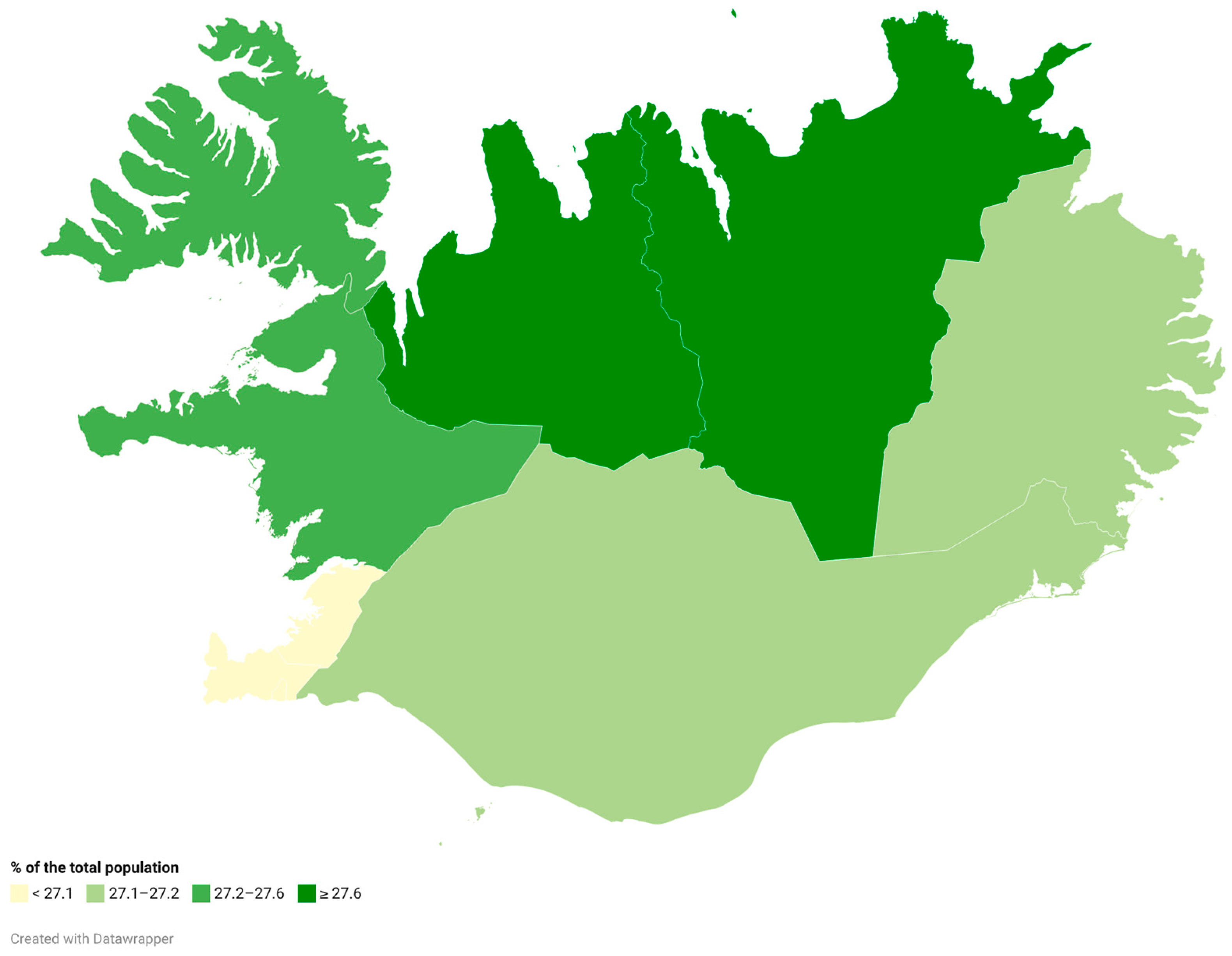
Figure 2 depicts the total number of estimated populations in Iceland’s regions who associate strongly with the statement that nature is very important. There are no significant variations between the regions. The highest percentage of estimated respondents feeling that nature is very important is observed in Norðurland Vestra (28.0%) and the lowest in Suðurnes (26.1%).
As noted in the previous section, one of the key advantages of spatial microsimulation is the ability to combine different variables from the microsimulated small-area (regional) microdata set.
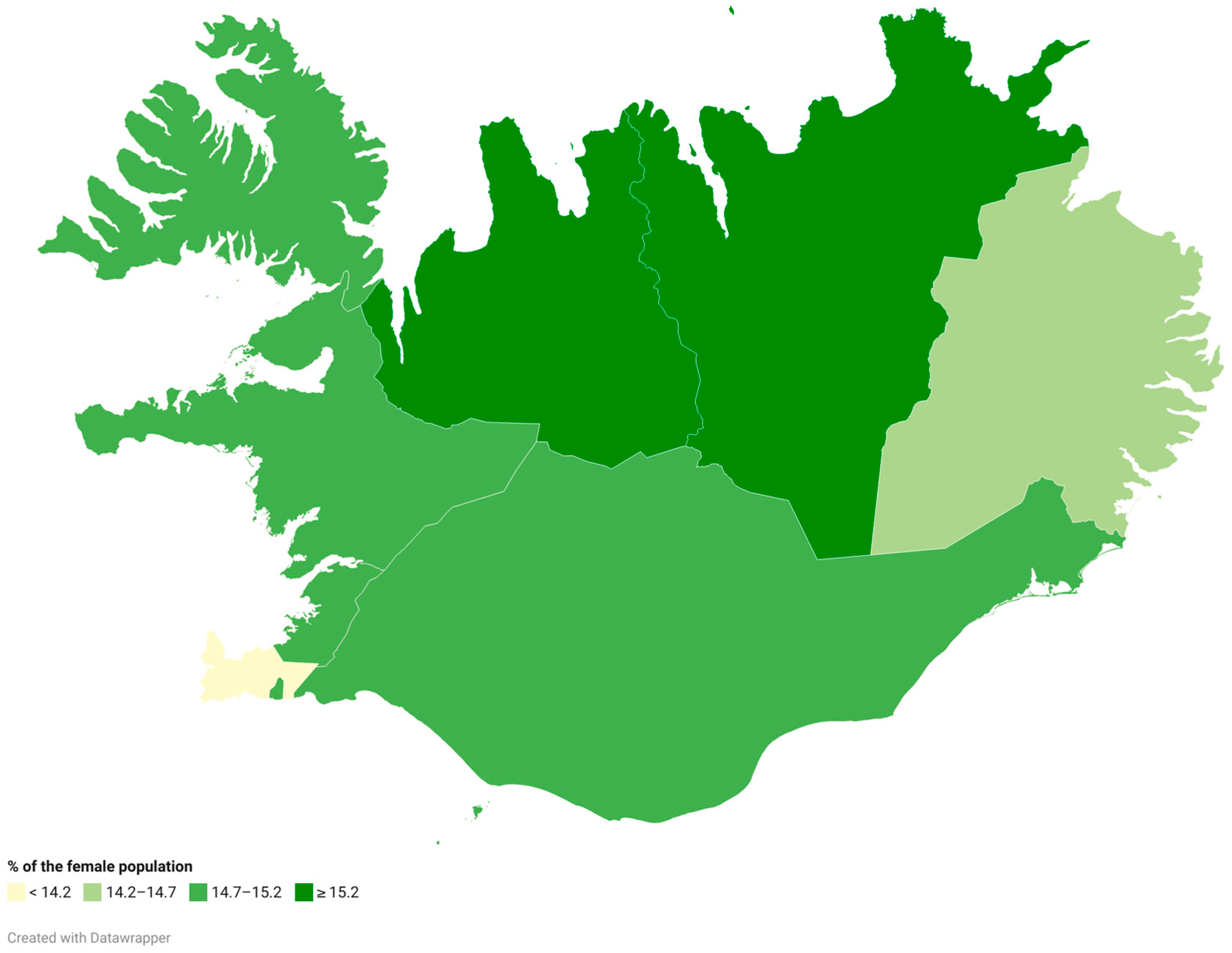
Figure 3 and
Figure 4 combine the gender and the social attitude variables used in
Figure 2. The highest estimated percentage of male respondents strongly identifying with environmental values (
Figure 3) is in Austurland (12.6%) and the lowest in the capital region (11.9%). For female respondents (
Figure 4), the highest estimated share strongly identifying with environmental concern is in Norðurland Vestra (15.7%) and the lowest in Suðurnes (13.7%).
Figure 5,
Figure 6,
Figure 7 and
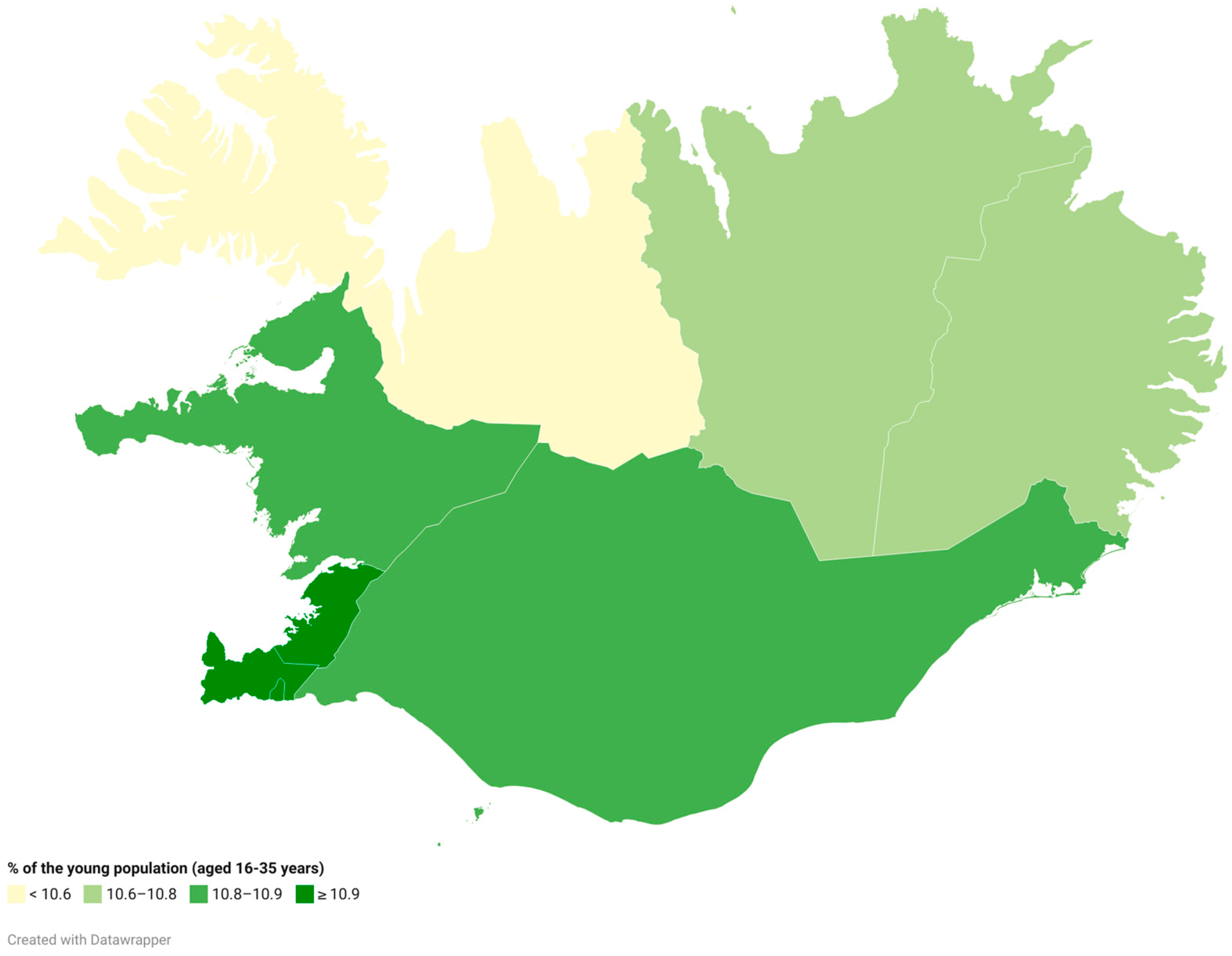
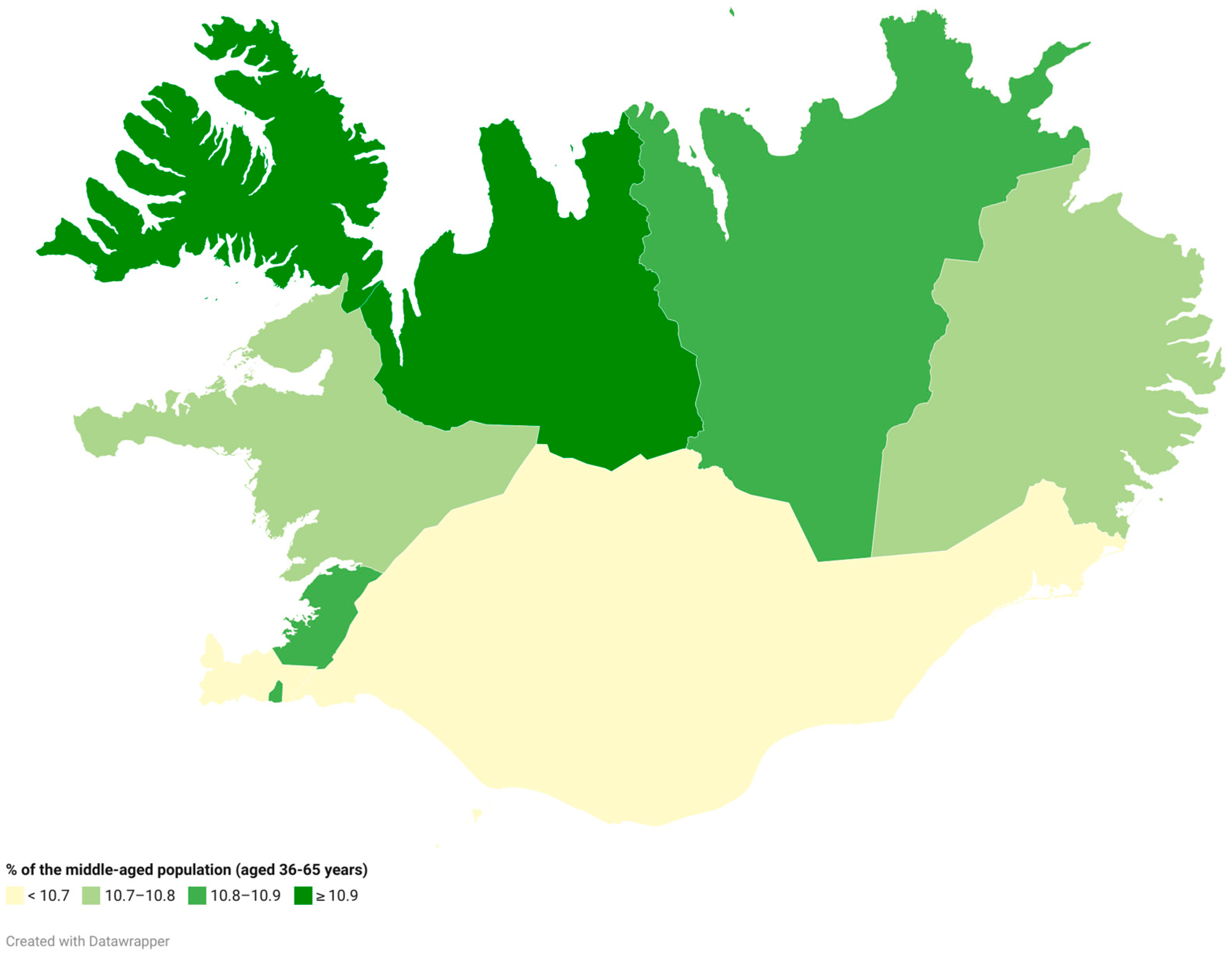
Figure 8 combine the social attitude variable with demographic information to show differences between areas and across broad age groups (a younger group, those up to 35 years old; one in a middle, 35–65 years old; and the older population, those aged 65 and over).
The highest estimated share of young people (under 35) strongly identifying with caring for nature (
Figure 5) is in Suðurnes (11.6%) and the lowest in Norðurland Vestra (10.3%).
Figure 6 shows the estimated spatial distribution of the population aged 36–65 years identifying with the statement that nature is very important. Among this population group, the highest estimated share expressing strong environmental concern is in Norðurland Vestra (11.1%) and the lowest in Suðurland (10.6%).
Among older people (65+), the highest estimated support for strong environmental concern (
Figure 7) is in Norðurland Vestra (6.7%) and the lowest in Suðurnes (3.8%).
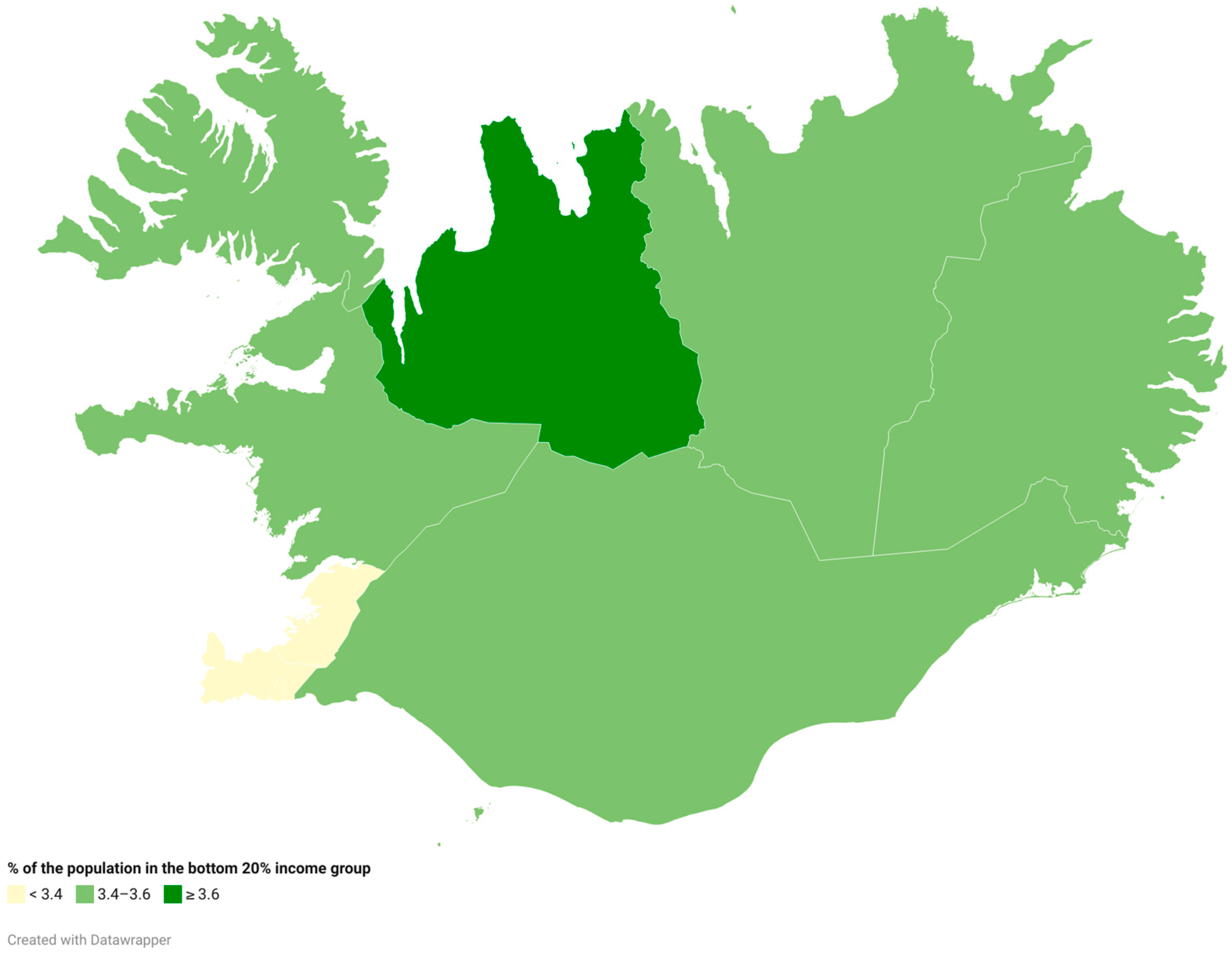
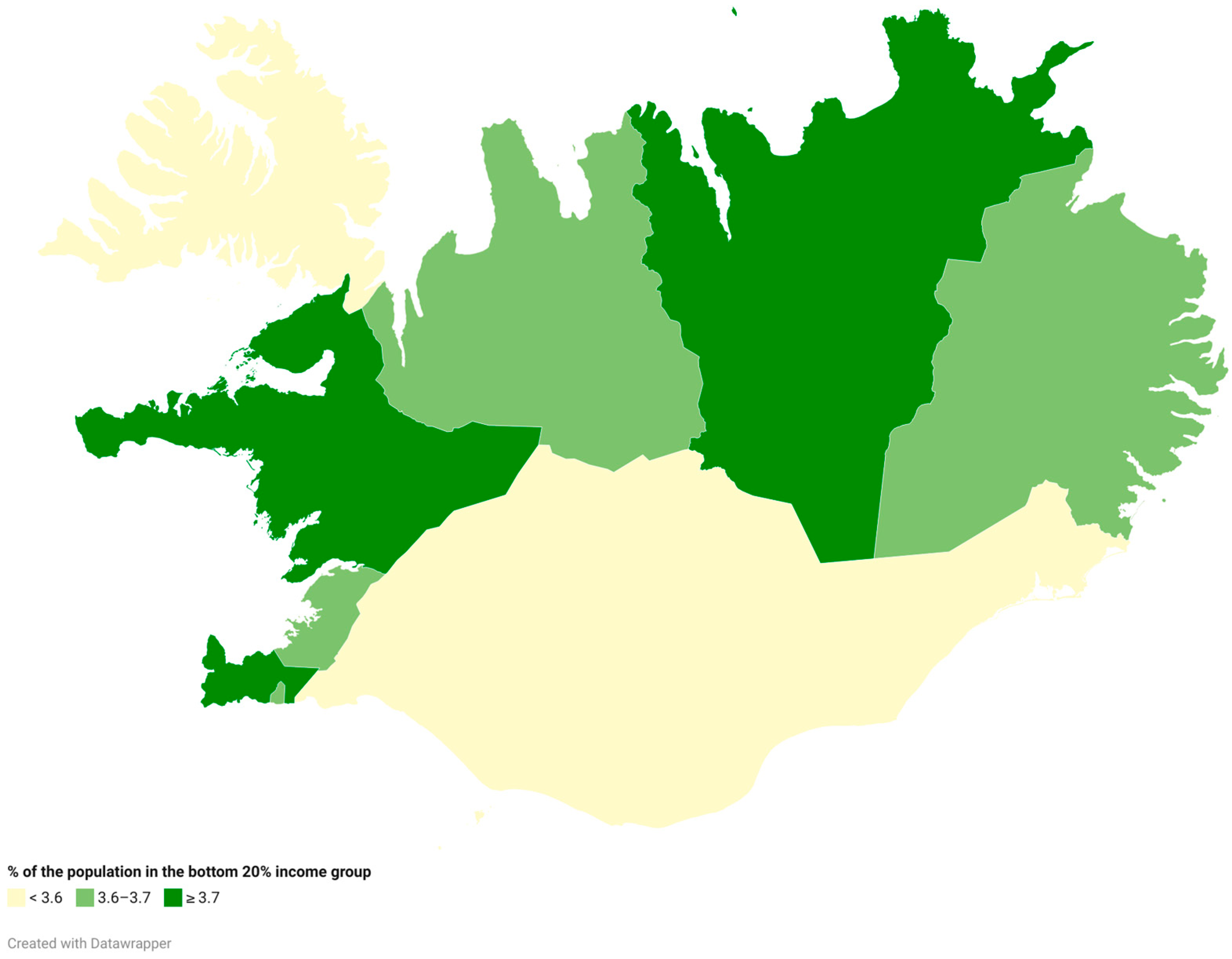
The next maps show the estimated differences in social attitudes towards nature amongst the population in the bottom 20% and top 80% income group across Iceland’s regions. This map may be particularly relevant to the EGD pledge that there should be no people or places left behind. To this end, it is interesting to consider differences pertaining to nature and climate change-related variables and social and spatial inequalities. In addition, it could be argued that conducting this type of analysis in an island nation or island region setting (and especially in cases where remoteness and smallness may be significant factors) may offer a different perspective regarding the sense of belonging and socio-spatial justice, also considering the discussion in
Section 2.
Among those in the lowest income group (bottom 20%), the highest estimated percentage showing strong concern for nature (
Figure 8) is in Norðurland Vestra (3.6%) and the lowest in Suðurnes (3.0%).
Among those in the top 80% income group, the highest estimated share expressing strong environmental concern (
Figure 9) is in Vesturland (3.7%) and the lowest in Vestfirðir (3.51%).
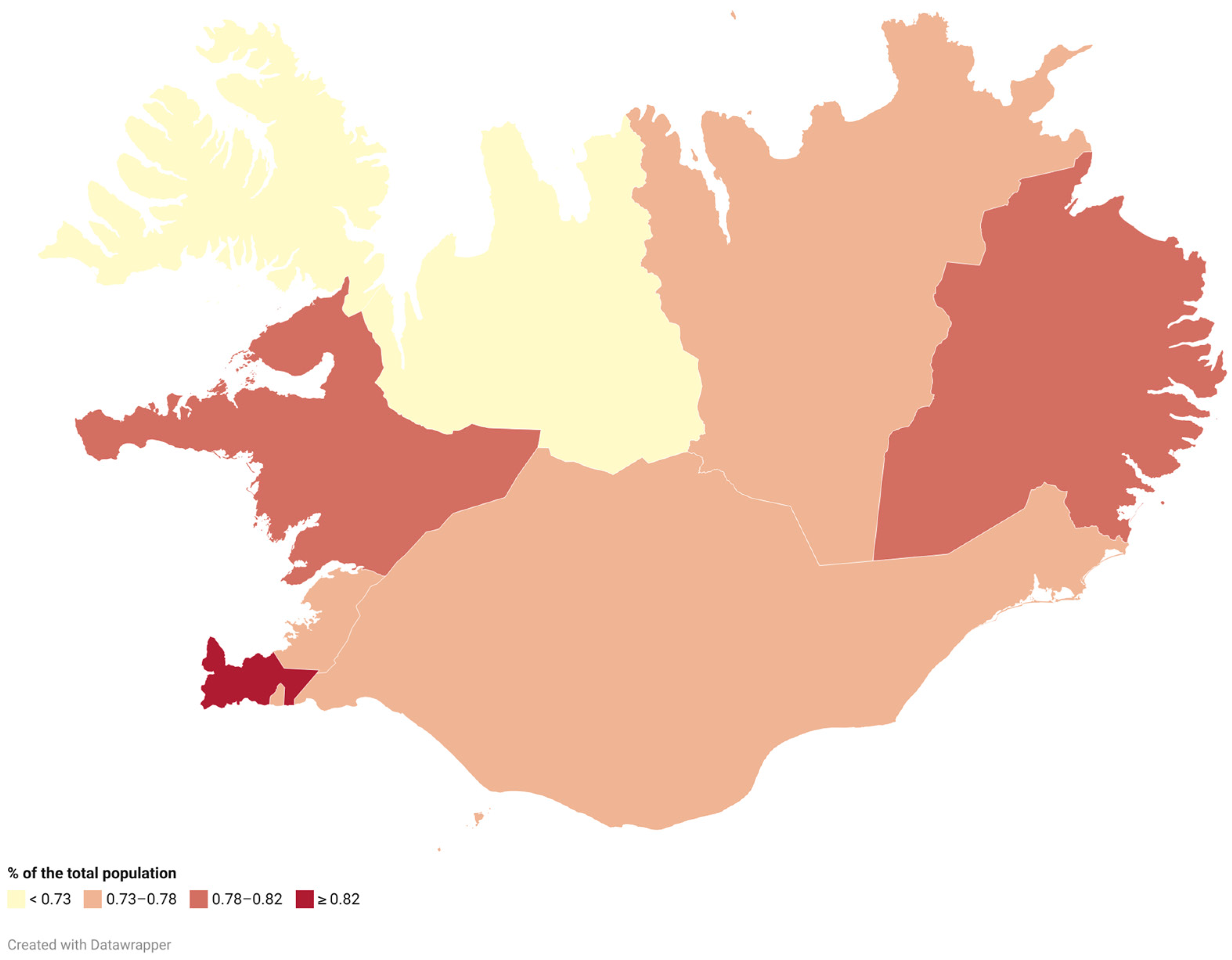
Looking at the other end of the social attitude variable that we consider,
Figure 10 shows spatial patterns for the total population who do not identify at all with the statement that nature is important.
The highest estimated share of respondents stating that nature is “not like me at all” (
Figure 10) is in Suðurnes (0.87%) and the lowest in Norðurland Vestra (0.69%).
6. Discussion and Conclusions
This paper has aimed to explore the potential of spatial microsimulation for understanding islandness through the case of green citizenship in Iceland. The results of the SimIceland model indicate that a large share of people in Iceland identify with the importance of caring for nature and the environment, while only a very small share do not identify with this attitude. This pattern aligns with earlier surveys and qualitative work showing that Icelanders hold deep emotional and ethical bonds with their natural surroundings (
Ólafsdóttir and Sæþórsdóttir 2020). However, the analysis still indicates differences across regions and demographic groups. Overall, the share of people responding 1 (“very much like me”) is high and relatively consistent across all regions, ranging between 26% and 28%. While the differences are small, there are still some clear regional variations. Norðurland Vestra shows the highest response rate of 1 across most groups, while Suðurnes consistently shows the lowest response rate. Norðurland Vestra is one of the more rural regions with low population numbers, and Suðurnes is more densely populated and in close proximity to the capital Reykjavík. Suðurnes’s heavy international-tourism dependence and subsequent infrastructure development contrast with Norðurland Vestra’s agricultural focused economy and lower in-migration. The results therefore indicate urban–rural variations in environmental attitudes, which complements studies that highlight varying and at times conflicting values and interests connected to the environment (
Stoddart et al. 2024;
Ólafsdóttir and Sæþórsdóttir 2020;
Kokorsch and Gísladóttir 2023).
For demographic patterns, there is a higher share of women who identify with the statement for response 1 than men. Younger (<35) and middle-aged (36–65) groups show higher response rates of 1 than older (>65) adults. That young women are more concerned about the environment in Iceland is, amongst others, reported by Icelandic Climate Organisations. Lastly, there is minimal difference between the bottom 20% and top 80% income groups, indicating that income levels are not a significant intersecting variable in the context of Iceland. These spatial and demographic patterns indicate that environmental attitudes intersect with complex, place-specific social and environmental dynamics, even within a relatively small island nation like Iceland.
This aligns with the conceptualisation of islandness as plural and diverse experiences and conditions within islands and island communities (
Foley et al. 2023;
Baldacchino 2004;
Royle and Brinklow 2018;
Connell 2023). By making visible this diversity of environmental attitudes within Iceland, the SimIceland model challenges assumptions of a homogenous island community. Instead, the importance of engaging with place and context at a micro-scale is highlighted. These findings challenge assumptions of homogeneity often associated with island communities and highlight the analytical relevance of islandness as a concept that takes locality and plurality seriously. Drawing on work on islandness and work on climate and environmental adaptation in islands, we know to take these internal variations seriously for ensuring their success.
The application of spatial microsimulation to the Icelandic case demonstrates that there is internal diversity of environmental attitudes which are shaped by intersecting social and spatial factors. While the model applied in this study is kept simple on purpose, the findings indicate that there is great value in further developing and applying more complex models. The results indicate that spatial microsimulation is a method that is sensitive to micro-scale variations and can be potentially used to address the particular and nuanced dynamics of island contexts. The work presented in this paper provides a demonstrator and an illustrative example using very simple and publicly available data which can be used as a basis for more comprehensive and sophisticated analysis (which could include additional small-area constraints as well as more comprehensive surveys and dynamic models). Furthermore, from a practical point of view, spatial microsimulation works well with limited data, which is often the case in small island settings. Consequently, this approach contributes to the methodological gap in work on islandness by offering a transferable, scalable, and context-sensitive methodological framework that can complement existing qualitative approaches.
The insights from this study are also important for improving green citizenship initiatives, as they point to the need for strategies that are place-based and sensitive to local context, even on a micro-scale. We therefore highlight the importance of moving beyond generalisations to sensitivity to specific intersections of place, socio-demographic characteristics, and environmental attitudes (
Lazrus 2012;
Connell 2023;
Foley et al. 2022). Place-sensitive strategies and more participatory engagements are necessary to address and engage different regional populations, including differences between more rural areas (like Norðurland Vestra) and more urbanised and densely populated regions (like Suðurnes). Insights and visualisation produced from SimIceland can be used in, e.g., citizen assemblies or other such established deliberative platforms as a foundation for dialogue and deeper understanding of and engagement with the complexities of local green initiatives.
Lastly, we argue for the value of the spatial microsimulation model in combination with public participatory approaches to enhance both democratic legitimacy and spatial sensitivity. For example, the results, as the regionally disaggregated examples for environmental attitudes in this paper, can serve as a foundational input of a web-based Participatory GIS survey (using the open-source PPGISr R package) that collects geocoded preferences from a stratified sample of Icelandic residents. This could also help to further refine the spatial resolution of the model. Participatory mapping approaches are increasingly used in shaping land-use policies in Iceland (
Hennig et al. 2025;
Tverijonaite et al. 2022;
Wilke 2023). By integrating spatial microsimulation outputs with participatory public-value data, it becomes possible to generate fine-grained “acceptability surfaces” that combine predictive and empirical dimensions of public support. These can be overlaid onto contested development zones, such as proposed wind-farm sites, afforestation areas, or other land uses, helping to identify socio-spatial conflict hotspots and develop mitigation strategies to address local concerns (
Kajosaari 2024;
Ampatzidou et al. 2018).
Such a hybrid methodology does more than visualise attitudes, it enables deliberation. It provides a platform where micro-scale spatial variations (e.g., by gender, age, income, or region) are not only represented but can feed into actions in the planning process. Combining microsimulation with participatory mapping for a transparent and evidence-based process has the potential to strengthen public trust in decision-making through the integration of both qualitative input and quantitative evidence. The results of the spatial microsimulation place locality at the centre of discussions and can create a basis for co-designing strategies. For example, observing the spatial differences between rural and urbanised regions, gender, and income invites a deeper, micro-scale conversation about green attitudes and initiatives that can move beyond purely environmental concerns. Because the output can be spatially visualised, citizens’ assemblies, municipal councils, and grassroots groups can all use the maps as a shared reference point. In practice, the results of the SimIceland model can lower technical barriers and give stakeholders a concrete basis for co-designing green strategies that fit their own island realities. Therefore, the integration of spatial microsimulation with PPGIS approaches can provide a supportive basis for transparent, citizen-informed green planning and policy making in and beyond island contexts.
This paper has presented the SimIceland spatial microsimulation model as a novel approach with promising potential for understanding islandness, green citizenship, and their intersections. Given the arguments and discussion in
Section 2 and the follow-up presentation of the modelling approach and results, we believe that the work presented in this article highlights the potential of a spatial microsimulation model in combination with public participatory approaches to support local decision-making in islands and for islands. The findings reveal demographic and spatial variations in environmental attitudes, highlighting the diversity and plurality of island societies. The analysis and results are intentionally simple and operate at the relatively coarse resolution of Iceland’s main regions, but the results provide valuable insights that indicate productive potential. Even at this scale, the model captures meaningful patterns of spatial and demographic variations that challenge assumptions of homogeneity in small island states. The spatial microsimulation’s sensitivity to micro-scales, its capability to be applied in places with limited data, and the potential of generating visual outputs make it especially well suited to island research and practice. When combined with participatory methods, such as PPGIS, this approach holds great potential for more bottom–up, context-sensitive, and participatory climate governance. The SimIceland model is open access. The model and data presented in this study are available on GitHub at
https://github.com/Worldmapper/sim-iceland, and we conclude by calling for further developments and applications of spatial microsimulation within island contexts.

