2. Sustainable Urban Development, Urban Blue Space and the Central Seattle Waterfront
The Central Seattle Waterfront is a paradigmatic example of a unique public asset enjoyed by coastal cities: blue space [
1,
2] Over the last several decades, the concept of green space has become familiar to urban designers, planners, environmentalists and community activists; however, the equally important attributes of urban waterways and waterfront sites are rarely understood as constituting their own species of urban space, whose urban political ecology [
3] is essential to the sustainable development of cities and urban regions.
Sustainable urban development is development that, in the words of the famous 1987 UN Brundtland Commission Report, “
meets the needs of current generations without compromising the ability of future generations to meet their own needs” [
4]. It furthermore recognizes that human activity is concentrated in cities and urban regions, which are thus vital sites for development reform and sociopolitical transformation [
5,
6]. The Open Working Group on Sustainable Development Goals (SDGs), convened by the UN in January 2013, currently includes a goal explicitly linked to cities and human settlements in its draft SDGs. The city of Seattle has made a longstanding and visible commitment to sustainable development, creating an Office of Sustainability and the Environment in 2000.
Models of sustainable development have evolved to include three, and sometimes four, fundamental pillars: economic, environmental, social and cultural (if a fourth pillar is included) [
7,
8]. By addressing environmental, sociopolitical and cultural aspects of economic growth, sustainable urban development is meant to ameliorate the degenerative effects of unchecked market economies [
9], protecting the human and non-human populations of urban social-ecological systems. Due to its significance to the economic, environmental, social and cultural patterns of urbanization, urban blue space is an ideal place to consider the pillars of sustainable urban development, in practice.
There are distinct social and ecological dimensions of urban blue space [
10]. It is a social space of gathering, labor, economic exchange, recreation, subsistence fishing, cultural tradition and journey-making, as well as an ecological space of watershed catchment, primary productivity, near-shore habitat, species migration and, often, environmental degradation. Urban blue space is a more complicated concept than “waterfront” and better captures the intersecting imperatives of sustainable urban development. While a waterfront suggests a firm boundary—literally, that which fronts the water, with connotations forged in the experience of late modern cities, namely trade, piers, industry, tourism and retail/leisure promenades—urban blue space is broader, more complex and more permeable. It is a kind of place that makes room for the ecological, in both a social and an environmental sense. In the same way that “green space” signals a civic and environmental good, urban blue space suggests a shared public place. It is adjacent to, part of and informed by the characteristics of the water, sky and associated aquatic ecosystems that extend beyond the city’s jurisdictional boundaries. Urban blue space is a regional commons.
Urban blue space as a site of sustainable urban development must be understood at a minimum of two intersecting scales: the local and the regional. While urban blue space is also constructed at the national and global scales—for instance through federal policies and investments regulating the natural environment and engineering waterways; and through international processes, such as maritime trade, tourism and global capital investment—the local and regional scales are highlighted here as the discretionary policy space for project planners, designers and related governance actors. Urban blue space is at once highly dependent on the capacities and interests of a locally bounded jurisdictional authority—a city government, for instance, or perhaps a parks district or a port authority—while simultaneously occupying an important place in regional systems, such as watershed function, transportation networks and labor economies. Adopting the term implies not just an acknowledgement of the existence and importance of these urban waterway spaces, but also a critical examination of their design, management and relative accessibility for urban residents [
2,
11,
12], at both the local and the regional scale. Is the “public trust” [
13] of the urban waterway as an environmental resource being protected as a common good? Is the “right to the city” [
14] of urban residents being enabled through waterfront land uses? These are essential questions with respect to urban blue space, of which waterfront revitalization projects are an important and high profile example.
The redesign of Seattle’s Central Waterfront, which was initiated by the city’s Department of Planning and Development in 2003, is part of a worldwide movement in urban waterfront redevelopment that has been underway for decades [
15]. While this movement has been lauded by some as a timely reclamation of downtown industrial piers and urban docklands abandoned to the modern exigencies of global shipping, now concentrated in large, container port complexes separate from the downtown core, it has been characterized in less rosy terms by others. Waterfront projects are criticized for offering a kind of bread-and-circus imaginary to the public paying for their design, engineering, construction and maintenance [
16], while those who benefit most from such blue space investments are the private property owners who develop housing, commercial and retail uses at or adjacent to such sites [
17]. Scholars note the tendency to privilege established economic interests over grass-roots, community stakeholders in developing waterfront plans [
18] and to undervalue deep environmental remediation in favor of surface forms of “green” engineering that maintain inequitable patterns of development [
19].
True to its reputation as a progressive, process-driven and environmentalist city, Seattle is making an effort to take such criticisms seriously in its current Waterfront Seattle Project [
20]. Moreover, the city is not new to waterfront redevelopment. Earlier planning efforts included a Citizens Waterfront Task Force (1970) comprised of not just business, but also labor, tribal, manufacturing and design leaders [
21]; one of the first initiatives in the collaborative planning style for which Seattle is known [
22]. Unfortunately, the outcome of this early effort, Waterfront Park (1974), was poorly integrated into the city’s circulation patterns and failed to catalyze the hoped-for regeneration of the area.
Waterfront planning in Seattle continued through eras of zoning use overhaul (1980s) and port property reorganization (1990s). An ambitious plan to redevelop the waterfront corridor was approved by City Council in 1988; however, it lacked the funding to be fully implemented [
21]. Throughout this time, heavy traffic on the viaduct highway separating downtown from the waterfront loomed as the true impediment to waterfront change. Noisy, physically divisive and experientially obstructive, the traffic on the SR-99 Alaskan Way Viaduct seemed to make any real transformation of the waterfront unlikely.
This changed with the 2001 Nisqually earthquake, during which the viaduct highway and the seawall supporting it were damaged and deemed seismically unsafe [
23]. Following feasibility studies to consider rebuilding the viaduct, tearing it down and relying on surface street capacity or boring a tunnel to carry the highway through downtown, as well as extended public debate and political wrangling, the tunnel replacement strategy was embraced by the city, the state and the port in 2009 and approved by Seattle voters in 2011. For the first time since the highway was built in the 1950s, waterfront planning gained new momentum, and the opportunity to do justice to the site seemed finally to be on the horizon.
After the Nisqually quake, collaborative waterfront planning was reactivated, not only by the city, but also by a grassroots campaign, “Waterfront for All” [
24]. In 2011, this group helped populate a new Central Waterfront Committee convened by the city, which hired the landscape and urban design firm, James Corner Field Operations, to lead a new planning project (this committee then became part of Waterfront Seattle, a partnership between the Seattle Department of Transportation, Planning and Parks Departments). Importantly, the Waterfront for All report also provided the tagline for the project’s Guiding Principles, which repeatedly emphasize inclusion. From a spring, 2013, progress report: “Waterfront Seattle will set a new standard for public access and participation in the decision-making process, with the goal of making ‘Waterfront for All’ a reality” [
25]. In addition to organizing dozens of public meetings and waterfront events, the Waterfront Seattle website includes a library of over 300 documents stretching back to 2010: presentation materials, meeting minutes, technical and design studies and committee reports.
However, outreach and transparency are famously challenging goals in pursuit of the democratic deliberation necessary for true inclusion, which demands a willingness to frame and host difficult conversations beyond a project’s inner circle [
26]. Moreover, megaprojects, such as Waterfront Seattle including the replacement of a failing seawall, the controversial tunneling of a state highway and the redesign of an iconic, central urban public space, move forward on a notorious tide of political horse-trading, sanitized public narratives and realpolitik willing to continually elevate ends over means [
27,
28]. The sheer challenge of getting such projects done enlists and accrues the too-familiar path dependence of known ways of doing things [
29]; for instance, the seemingly inevitable reversion to craftily managed public perceptions and reliance on deliberately vague cost estimates.
In this case, the progress of the overall waterfront project depends on the seawall and highway replacement. In late 2013, the highway tunnel-boring machine became stuck south of downtown, 60 feet below ground. Repair estimates and a revised timeline for the project have not been optimistic [
30]. Furthermore, wealthy cities like Seattle are particularly prone to the danger of mistaking collaboration amongst élites for democratic inclusion [
31]; and driving to lure a highly-mobile “creative class” through public investments in urban redevelopment, with limited concern for the underbelly of growing income inequality and place de-historicizing signaled by the term [
32]. Despite the avowed emphasis on inclusion in Waterfront Seattle, there is little evidence of actively countering this trend.
Thus, this essay offers four additional ways to understand doing justice on the Seattle waterfront, drawing on the four pillars of sustainable development and seeking to actively anticipate and counter the demanding, totalizing and somewhat predictable exigencies of megaproject construction in a twenty-first century, creative class city. These ideas of justice stake out and elevate alternative conceptual terrain in site design and development of the Central Seattle Waterfront. They are concepts that demand accountability to the place as more than a spectacular aesthetic landscape; they unsettle and complement that interpretation with an understanding of the urban waterfront as an essential place of economic variety, environmental equity, social difference and tribal presence.
3. Justice and Urban Blue Space Planning
Theories of justice constitute a large interdisciplinary field unto itself [
33,
34]. While there is an argument to be made that economic position determines the advantages that constitute social power or that social justice by definition includes environmental, tribal and economic outcomes, this essay maintains a distinction between them. Each concept of justice presented here illustrates different challenges in waterfront planning, with specific histories and, therefore, distinct ramifications. For instance, characterizing access to governance resources and political voice as a purely economic dynamic ignores the role of racial and gender norms in the marketplace. Similarly, while tribal claims ostensibly fit within the broad category of social justice concerns, the history of displacement and oppression of local tribes, in the Puget Sound region, generally, and its urban shorelines specifically, merits increased attention in waterfront planning. Therefore, the next sections examine concepts of economic, environmental, social and tribal justice on the Seattle waterfront.
By framing urban blue space planning in this way, the pillars of sustainable urban development are made more real and specific, enabling an empirical consideration of the issues and challenges involved. Because indigenous people have led the international movement to adopt “culture” as a fourth pillar of sustainability [
35,
36] and because the term is nevertheless frequently assumed in practice to mean a generalized, broad-based emphasis on museums and arts-based events [
7], the significance of tribal relationships to urban shorelines is explicitly named here as the fourth dimension of sustainable development for urban blue space.
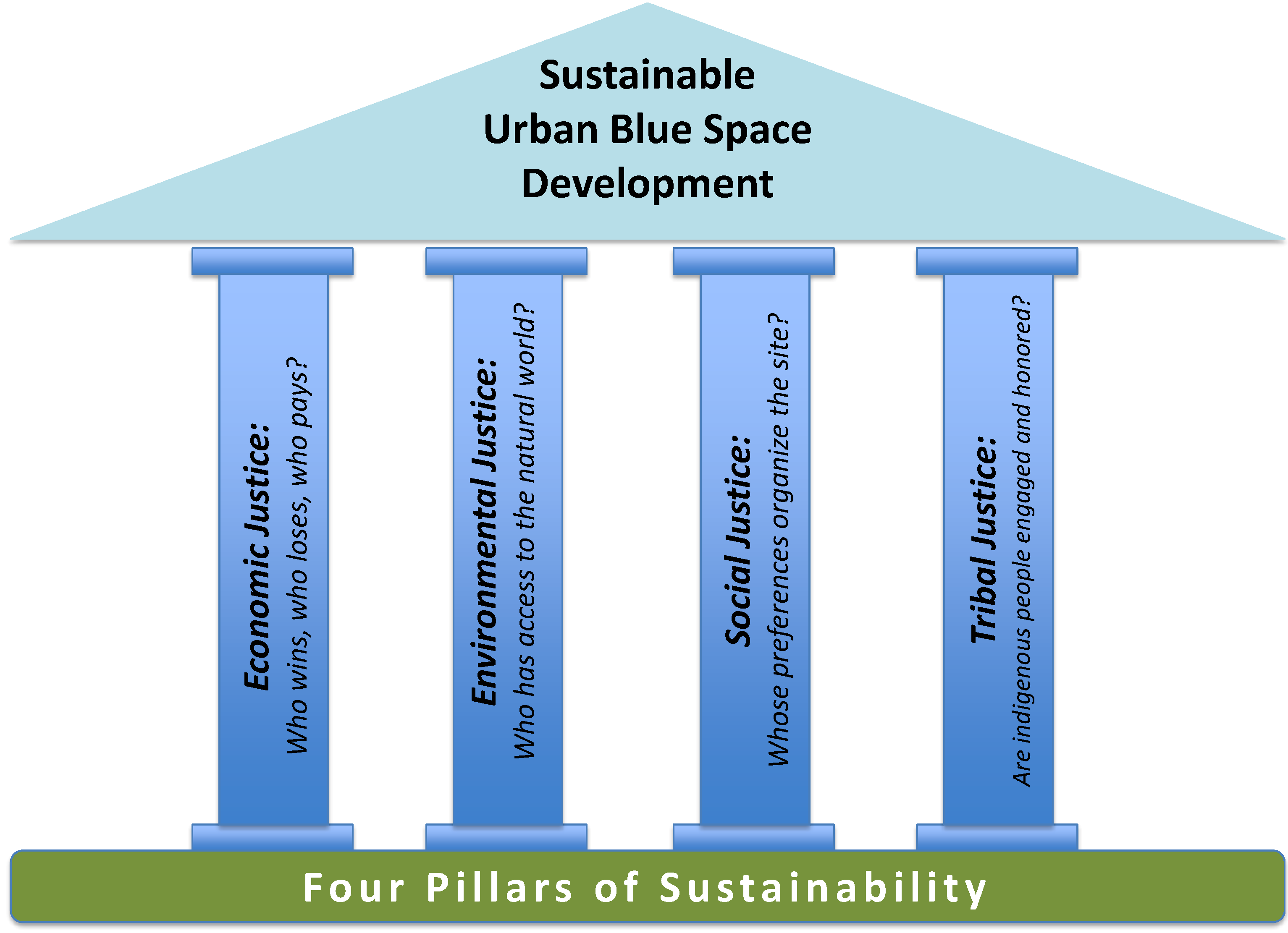
Figure 1 details this model: the sustainable development of the central Seattle waterfront requires structural attention to each of the four pillars.
Figure 1.
Four pillars of sustainable development for urban blue space.
Figure 1.
Four pillars of sustainable development for urban blue space.
3.1. Economic Justice
For urban studies scholars, ideas of economic justice and urban political economy are perhaps most closely associated with David Harvey [
37], John Logan and Harvey Molotch [
38], and Susan Fainstein [
39]. Each locates the engine of uneven urban development outcomes in people’s relative access to capital, which is itself increasingly global [
37,
38,
39]. This work details the ways in which real estate development imperatives and local governments’ need for tax revenue work together to downgrade the ability of smaller, local businesses and less revenue-intensive land uses to influence urban development outcomes. This unforgiving political economy has intensified in an era of eroded public resources and the potentially circumscribed aims of quasi-public organizations, private conservancies and public-private partnerships formed for the development of public spaces and delivery of public services. These “entrepreneurial” arrangements [
40] can be harder for local people and businesses to penetrate and hold accountable, than traditional city and state actors [
41,
42]. Thus, economic activity is characterized by a concentration of power amongst well-capitalized private actors, who develop urban space according to their interests; and unwitting and/or disingenuous complicity on the part of public actors, who have adopted ever-more businesslike practices in the “creation of public value” [
43], enabling what some scholars call private “extraction of value” [
44] as the presumed purpose of urban development.
On the Seattle waterfront, this dynamic manifests in a couple of important ways. First, the ongoing presence of the Port of Seattle in a zone that no longer hosts significant shipping activity means that prime shoreline real estate is held by an entity with little way to relate the site to its historical function. As Peter Brown has shown [
45], port authorities have become central actors in urban waterfront redevelopment, transforming themselves into diversified organizations whose purpose has become more complex and business-oriented than support for maritime cargo shipping. For many port authorities, a broad definition of economic development suggests that “return on investment (ROI)” is the ultimate measure of public benefit. Accordingly, the Port of Seattle has sought to maximize its economic position and developed its central waterfront properties to accommodate tourism and conference uses. This is consistent with the redevelopment of piers south of the Port’s properties, which house enormous seafood restaurants, amusement rides, souvenir shops and large cruise ships. These highly seasonal uses appeal predominantly to summer tourists as opposed to year-round city residents; however, they provide solid lease returns. Thus, the best views of Elliott Bay, from former warehouses blocking the water from the city, are reserved for tourists willing and able to pay for them.
Second, and related, local blue-collar labor, small-scale economic uses and non-economic uses are marginalized on the waterfront, in a process that began with the off-siting of maritime shipping and trade, but accelerated with the introduction and promotion of the tourism economy. Large private entities, such as international hotel chains, regional and global cruise ship lines and chain seafood restaurants dominate the central waterfront corridor, contributing to a sense of hegemonic tourist tastes and predictable replication, where the hotel/transport/restaurant experience is eerily similar, whether one is in Seattle, Boston or San Diego. By contrast, while the Pike Place Market on the bluff above the waterfront has also become a tourist destination, it has retained its core support for local merchants, growers and vendors and serves as a farmer’s and seafood market of choice for Seattle residents, a dynamic and free public space, as well as a popular location for small restaurants.
Much of the discourse surrounding proposed plans for the new waterfront emphasizes improved view corridors and new opportunities for development resulting from the elimination of the viaduct highway. In fact, the viaduct blocks views mainly for residents of the adjacent buildings, increasingly high-end residential in recent years; or for the as-yet un-built complexes envisioned for sea-level sites liberated by the razing of the elevated structure, for which economic pressures will increase, if the Local Improvement District (LID) funding mechanism for the project is approved [
46]. Meanwhile, views of the water for ordinary people walking on city sidewalks are only affected by the viaduct in a handful of locations and, for the most part, will still be blocked by existing buildings; ironically, the best views of the water are on the viaduct itself.
What might a heightened focus on economic justice bring to the central waterfront planning process? Scholars concerned with the identification of alternative paths forward for economic and real estate development emphasize the need to nurture “a concern with justice” in the allocation of public development dollars and the “mobilized constituency” that demands it [
33]; and “networks of equivalence” [
31] capable of challenging and infiltrating the status quo. On the central waterfront, this might mean: What are the businesses that might bring more local people to the waterfront regularly, including craftspeople, local entrepreneurs and water-related laborers? Who are their representatives and advocates? Will it be possible to buy a meal for less than $10? Are there reasons to come to the waterfront, if one does not have money to spend? Are there ongoing industrial uses and sites of manufacturing and production? Will affordable housing be part of new residential developments? Is there regular, accessible public transit serving the corridor? Have all of the best views of the water been ceded to users willing to pay for them?
These are some of the questions the planning team must explicitly frame and examine in order to plan for and protect land uses that will otherwise be further pushed aside by well-known urban development dynamics. In addition, local advocacy groups for economic opportunity should focus on the central waterfront redevelopment as an important issue. In 2014, Seattle became the first jurisdiction in the country to approve a minimum wage of $15/h. In the public discourse surrounding this vote, the recently completed South Lake Union development was regularly enrolled as an example of the city’s growing income inequality, with the sense that service jobs connected to such significant place-based wealth can and should pay a living wage [
47]. South Lake Union is a formerly industrial waterfront area north of downtown Seattle, redeveloped to include a new corporate headquarters for Amazon, thousands of condominiums, high-end restaurants and retail venues and a new home for the Museum of History and Industry (MOHAI). It has been criticized as exemplifying patterns of polarized wealth and poverty that have come to define economically “successful” cities [
31].
As the Waterfront Seattle initiative moves forward, economic justice will require protecting and envisioning the character and land uses of the site to support activities other than revenue-intensive ones; enforcing improved affordable housing requirements with livable square footage for new residential developments; and balancing the need to protect and empower small businesses, in the midst of large ones meeting new minimum wage standards for service workers.
3.2. Environmental Justice
The classic environmental justice frame highlights the tendency for toxic, locally burdensome land uses, such as waste treatment plants or polluting industries to be disproportionately sited adjacent to low-income and minority residential neighborhoods [
48,
49,
50]. Historical analyses help to elucidate the structural racism behind this phenomenon [
51,
52]; and as urban regions grow, such disparities become magnified over time [
53,
54].
An environmental justice frame is also used to analyze access to locally beneficial land uses and natural resources, such as urban parks [
55,
56]. The restorative and recreational benefits of public green spaces are most likely to be within walking distance of predominantly upper-middle class and white urban neighborhoods, with relatively meager investments adjacent to lower-income and minority neighborhoods (
ibid.). This extension of the classic environmental justice perspective has also been applied to urban blue space [
2], finding that physical access not only to waterways, but also to the social practices that take place there are important and under-appreciated aspects of urban environmental equity.
Bringing an environmental justice perspective to Waterfront Seattle requires focus on three things: first, the relative accessibility of the waterfront site to different populations; second, the relationship between the central waterfront and public investment in other Seattle shoreline sites; and finally, the quality of the environmental remediation that takes place. These questions focus predominantly on what Robert Bullard calls the “geographic equity” of environmental planning and land use and enlist the fundamental paradigm of the environmental justice framework: seeking to anticipate and prevent environmental inequities before they occur [
49].
First, accessibility to the environmental resource of the waterfront blue space can be understood as an issue of site design. Are there places for people to get to, enjoy and touch the water? Are views of the water, supported by case law as an aspect of “public access” enabled by the Washington State Shoreline Management Act (1971), protected and provided? Accessibility is also an issue of the site’s proximity to different Seattle populations, via walking, bicycling, transit or automobile; lack of adequate transportation remains a significant deterrent for widespread enjoyment of Seattle’s blue space [
2] and urban environmental amenities more generally [
48,
57].
Second, environmental justice requires that Waterfront Seattle be considered in relationship to other sites of shoreline responsibility in the city. A notable area in need of significant public investment is the Duwamish waterway south of the central waterfront. Plagued by decades of industrial dumping and contamination, adjacent to relatively low-income and non-white neighborhoods, the Duwamish was designated a Superfund site in 2001 [
31]. As B.J. Cummings, a longtime leader with the Duwamish River Cleanup Coalition [
58] put it in a response to early plans for the downtown waterfront:
The downtown waterfront beautification costs more than plans to clean up the Duwamish, where Seattle has so far been unwilling to invest enough to provide for basic protection of human health. While the downtown waterfront plan might be cool, it would worsen the disparities in our city unless we protect the health of our Duwamish Valley residents, tribes and fishing families… [
59].
An environmental justice perspective highlights the discrepancy of investing over $400 million on a new central waterfront park [
60], more than $1 billion, including the various infrastructure elements [
61], while a nearby Seattle waterway lacks resources for long-overdue environmental remediation.
Finally, the idea that natural resources, such as shorelines are a public trust held in common by everyone [
13], has been controversial for city-builders seeking clear development rights; yet essential for urban citizens who would otherwise see their waterways turned over completely to private interests. As the philosophical basis behind the state’s Shoreline Management Act, the public trust doctrine implicitly endorses environmental equity as an issue of general social obligation. Thus, the quality and breadth of the environmental restoration that occurs as part of the central waterfront project, including the recovery of high-functioning intertidal zones, the re-introduction of migratory fish habitat and the opportunity for the public to witness and appreciate both, are investments in the urban blue space as an environmental resource essential to the well-being of the entire metropolitan Puget Sound region.
3.3. Social Justice
Social justice indicates a concern with social difference and with inclusive democracy, beyond questions of economic distribution [
62,
63]. Social justice scholars highlight the concentration of social power amongst those in the historical and/or cultural majority, to the relative detriment of groups and classes in the minority [
34]. The social justice perspective, thus, includes issues of site ownership, physical accessibility and local histories of outright discrimination, although arguably, these are also addressed through the other justice frames discussed in this essay. Beyond these explicit forms of social control, however, a social justice perspective also demands attention to the practices through which a place, such as an urban waterfront, is socially constructed and inhabited; what cultural geographers call the “social production of space” [
14]. It is through the social practices that become normalized in urban space, that the “right to the city” [
14,
64] is exercised, produced and sustained.
In this sense, a space that is putatively public and physically accessible can be unnerving or forbidding to someone without the established and familiar social practices to engage the site and, thus, feel comfortable there [
2,
65]. Furthermore, practices of the seemingly dominant majority—for instance, conspicuous consumption, dedicated leisure recreation, physical autonomy and assured safety—can be so outside the realm of habit, identity and availability for some, that they are experienced as signals of being non-welcome and excluded.
This perspective on social justice suggests that site programming for a public project of the magnitude of Waterfront Seattle should go beyond the preliminary need to make it physically accessible and open to the public. It asks: How will the urban blue space be produced by the practices that take place there? Will dominant patterns of socio-economic privilege be reproduced? That is, who belongs in the place; and is this mitigated by class, race and gender?
Planning theorists and cultural geographers describe the ways in which the urban public realm has become increasingly privatized, producing spaces that emphasize spending money to acquire goods and experiences as the social practice of choice [
66,
67,
68]. Such practices of consumption clearly exclude on the basis of economic class. However, social relations have themselves become more privatized, resulting in a general loss of activity and diversity in the public sphere [
69]. This phenomenon produces unequal effects by race, gender and sexual orientation.
Social scientists and historians detail the widespread effects of social practices of exclusion, such as racial segregation [
70,
71]. While enforced segregation is now illegal, biases of privilege and the spatial divisions established through once-legal residential and educational segregation persist. For example, the public spaces of downtown Seattle have continually been the site of cases of alleged racial profiling by local police officers [
72]. In 2011, the U.S. Justice Department found repeated violations of federal anti-discrimination and civil rights laws in their use of force [
73], and the Racial Disparity Project [
74] has highlighted the prevalence of race-based “trespass admonishments” that target people of color, in particular young black men, in public places [
75]. Will the central waterfront be an extension of this spatial practice?
Similarly, women can experience public space in very different ways than privileged men, with men’s dominant constructions of personal agency and masculinity, reproducing women’s feelings of vulnerability and fear [
76]. Feminist planning theorists reinforce the notion that women’s experience of urban space is far from singular [
77]; however, there are practices that remain the disproportionate purview of women in urban social life [
78,
79]: for instance, unpaid domestic work, the care of young children and mobility patterns that do not map onto the typical commute schedules for which public transit is designed. How does a public space such as the central waterfront provide a gathering place for such women, whose lives and labor have been made relentlessly domestic, private and marginal by the organization of late modern cities, such as Seattle? Dolores Hayden has argued that in overcoming such segregation, “new kinds of homes and neighborhoods might become the most powerful base in America for progressive political coalitions on urban issues” [
79]. For instance, the urban blue space could include a destination daycare/eldercare and universal pre-K, an initiative before Seattle voters in November, 2014, delivered on a bioregional environmental education model.
Finally, while Seattle is widely known as a gay-friendly city [
80,
81], tourism and gentrification have recently been associated with an increase in “gay-bashing” incidents in the Capitol Hill neighborhood, long considered the center of the local Lesbian, Gay, Bisexual and Transgender (LGBT) community [
82]. In 2013, there was a widely publicized, but unofficial report, of an alleged anti-gay altercation at a Ferris Wheel on the downtown waterfront [
83]. A New Year’s Eve arson fire allegedly set by an anti-gay activist in a popular nightclub highlights the gravity of current anti-gay discrimination [
84]. How do Seattle’s public spaces relate to this phenomenon; do they enact and enforce heteronormativity [
85]?
As a “quintessential part of the city” [
86], the central waterfront is a crucial site to anticipate and plan against practices of exclusion and oppression [
34,
87]. This requires including under-represented populations in project planning and site design, in intentional and substantive ways. Such inclusion is carefully specified in project documentation [
88]; however, to date, planning outreach has focused on “getting the word out” in a broad sense [
89] as opposed to directly engaging identified disadvantaged communities. Countering practices of exclusion also requires foregrounding the design question of how the blue space can actively engage and support difference.
Understanding social justice in this way intentionally moves urban development projects, such as Waterfront Seattle, beyond the increasingly common procedural emphasis of participatory planning, which tends to imagine itself as value-neutral and to replicate existing power relations within a city, into a more outcome-oriented perspective [
33]. If planning procedures have been made more open, but only a limited subset of residents takes advantage of this fact and development outcomes remain largely unchanged, the project cannot be understood as socially just. Decentralized, participatory governance arrangements only give rise to inclusive policy designs and physical spaces when diverse social groups have the organizational resources and experiential knowledge to take part in such processes [
90]. Thus, designing and running an outreach campaign is a necessary component of a major urban megaproject, but not a sufficient one if it is not explicitly designed to engage and represent underpowered urban populations.
3.4. Tribal Justice
The term tribal justice may call to mind the reservation-based judicial systems of American Indian tribes, but the phrase is used here to characterize the ongoing disparity between indigenous peoples and the settler society that displaced them. In the Puget Sound region, tribes are more visible than most other metropolitan U.S. areas: many place names have persisted; reservations are in close proximity to urban centers; totem pole and tribal wilderness iconography is widespread; and the environmental ethic for which the Pacific Northwest is known draws on the storied relationship between native people and the temperate, historically abundant natural setting [
91].
However, as historian Coll Thrush notes, the very concept of urban development in greater Seattle has depended on an enforced story of discontinuity with the tribal presence that preceded it; Indian history and urban history are understood to be mutually exclusive, with the latter requiring the obliteration of the former, both discursively and materially [
91,
92]. Places throughout the Puget Sound are urbanized through a continuous process asserting modernist, property-based claims to various sites: surveying, renaming, purchasing, selling, mapping [
93]. This seems to be a “done deal,” perhaps, a tragic and unfortunate power play in the great American era of expansion and industrialization, except that it is not altogether in the past. Nineteen Puget Sound (Salish Sea) tribes are as urban as any of the other 3.5 million people in the region, and members continue to live, work, gather, fish, worship and die in the place of their ancestors. Over the last several decades, treaty rights to regional shorelines, brokered in the mid-nineteenth century, have been upheld and re-asserted [
94,
95]. Because waterfront lands have been the most culturally and economically valuable and, thus, politically contested in the region’s history of tribal displacement and oppression; this raises important questions for the current Waterfront Seattle project.
The city itself is named for Chief Sealth, the Suquamish and Duwamish leader who provided support and guidance to early settlers and is remembered for an 1850s speech exhorting settlers to be just and careful, as “
the white man will never be alone” [
92]. In 1896, Chief Sealth’s daughter, Princess Angeline, died respected, but destitute, near the waterfront, having worked as a basket weaver and a washerwoman [
91,
96]. Her shack on the Elliott Bay tideflats was not far from the central waterfront site, where the most important Duwamish settlement on the bay was located and where some of the nearly 100 native longhouses burned by settlers were located [
97]. Such histories indicate the tribal interests that might support understanding the urban blue space as a “contact zone” between indigenous claims and state-based planning [
91]; a venue of deliberate, contested unsettling of planning and development practices through an emergent politics of difference [
98,
99].
Spatial recognition of Seattle’s native tribes tends to rely on interpretive gestures, such as plaques with historical notations or quotes, totem poles or discrete, static pieces of public art. While such installations are important, they potentially reinforce the intellectual remove between the existing city and ongoing tribal presence in the urban region. One exception is the Daybreak Star Cultural Center, a tribal base supporting active programming in Discovery Park, northwest of downtown Seattle. The Center resulted from a protest occupation of the former U.S. Army post, Fort Lawton, by local tribal leaders in 1970 [
100]. However, the site is far from major highways and arterials and poorly served by transit.
Tribal presence is barely visible in downtown Seattle and marginalized in public spaces. Tribal leaders and city residents were dismayed by the unprovoked shooting of Native American woodcarver John T. Williams by a Seattle police officer in 2010 [
101]. Some viewed it as illustrative of the disenfranchisement of tribal members in the city, as well as a culture of defensive violence on the part of local police. A totem pole memorial honoring Williams was erected at Seattle Center, near downtown [
102]. Today, the central waterfront remains a site of scattered, informal wood carving activity by tribal members, as well as selling of tribal wildlife icons and handmade jewelry.
At a Waterfront Seattle public outreach event in March 2014, project information stations (“Seawall construction”, “Adopt-a-Gribble”, and so on) were interspersed with several small groups that were not part of the official event: Native Americans seated on park benches soliciting carving commissions and displaying small collections of handmade items for sale. The incongruity was striking between the professionalization and resource-intensive materials of the project team tents, with their unified graphics, hand-outs, give-away items and quick activities; and the itinerant feeling of the Native American groups, testing phrases and methods of getting attention from passerby, holding up hand-made signs with craft prices or scrawled terms of trade for small carving projects.
The re-imagining of Seattle’s central urban blue space would be incomplete without the inclusion of the region’s first inhabitants. How can the waterfront engage and elevate ongoing tribal presence in the city, without falling into clichéd attempts to curate a representative and static historiography; and without reproducing the disparate power relations that construct tribal members as marginal actors in urban public space? The city and the design team have recently held outreach sessions with local tribes [
103], potentially a step towards the enactment of a contact zone, where coexistence can be reimagined and renegotiated, ideally such that territorial values surface and strengthen political rights [
91].
4. Urban Political Ecology: Doing Justice on the Waterfront
The intent of this essay has been to articulate ways of understanding justice on the waterfront as an endeavor in sustainable development for urban blue space, to complement and broaden the overwhelming focus generated by designers and boosters for doing justice to the site as an aesthetic endeavor. The physical nature of Seattle’s central waterfront as a paradigmatic urban blue space is stunning and full of potential, including exciting possibilities for environmental remediation through geo-technical engineering, economic development through site activation and improved circulation and social inclusion through improved access and public programming. Moreover, the political and financial management challenges of completing such a project are staggering, and it is not surprising that the exigencies of moving the megaproject forward have tended to subordinate the difficult work of building inclusive communities of practice [
26,
104] to address and empower the relationship of under-represented groups to Waterfront Seattle.
However, an urban blue space redevelopment described as a “once-in-a-lifetime opportunity” [
105] in a city that understands itself as committed to diversity, inclusion and sustainable development should foreground these additional concepts of justice. Improving cultural competency and reflective participatory practice on the part of city staff and consultants is an excellent first step, and Seattle has a deserved reputation for leadership on this front [
106]. The city is committed to participation, so much so, that the famed “Seattle Process” or “Seattle Way” is known for both its inclusionary ideals, as well as its reputation for valuing debate and analysis over results and action [
31]. Nevertheless, Seattle is typical of high-growth, creative class cities where knowable patterns of inequity are smoothly reproduced by the processes of urban land use development.
By naming specific areas of concern with respect to just outcomes on the waterfront, efforts can be proactively designed to prioritize key areas of deliberation. Moreover, it may be that such deliberation is best suited to smaller, limited groups, as opposed to being broadly participatory. A notable finding in a recent analysis of participation and inclusion by planning and public management scholars, Kathryn Quick and Martha Feldman (2011), is that more process does not necessarily lead to more inclusive outcomes [
26]. This resonates for many practicing planners and urban designers, who know that significant money and time can be spent on an exhaustive public process, with mediocre, yet costly results. In order to do justice on the waterfront, it may be more effective and efficient to identify the dynamics and outcomes that reinforce patterns of privilege and discrimination and proactively convene the leaders, groups and activists most impacted by such patterns and best poised to devise alternative paths forward.
For Waterfront Seattle, this means taking a critical and informed eye to the urban political ecology [
3,
107,
108] constituting the city’s blue space as a complex socio-natural construction. Urban political ecology conceives of the city as an ongoing production of intertwined social and ecological processes and demands “who produces what kind of socio-ecological configurations for whom” [
107]. With its deeply critical perspective, much of the work in urban political ecology rejects the interventionist impulse of urban sustainability scholarship; however, this essay enlists both traditions. While the justice perspectives presented here have been simplified and abbreviated, they are essential to sustainable urban development on the waterfront; a concept that requires equal emphasis on economic prosperity, environmental protection, social equity and cultural diversity.
Using concepts of justice to render the pillars of sustainability into empirically comprehensible terms initially raises more questions than it answers for Seattle’s urban blue space development. However, characterizing the challenges that exist is an important first step in addressing them. While it is beyond the scope of this article to propose detailed interventions, there are three areas of project planning practice where focused attention and intentional investments can help to ameliorate local and regional patterns of injustice in the development of urban blue space:
Participation must be targeted and proactive. The equity planning tradition [
109] provides a potential frame for adopting an intentional advocacy role into the outreach strategies of the project planning team, for instance to counter the increasingly disproportionate lack of access to resources amongst working and middle classes [
110]. Meetings should be held in venues other than high profile, downtown spaces, such as City Hall, the Seattle Art Museum and Seattle Town Hall, to include gathering places like schools, religious organizations and recreational clubs around the city, and “collaborative capacity builders” [
111] should be trained to identify, reach out to and listen to project ambassadors in neighborhoods throughout the city, building on a tradition of decentralized relational organizing [
22] for which Seattle is known. Moreover, the mechanisms and tools of participation, including visual, digital, auditory, printed and 3D materials, are themselves actors in governance networks [
112], engaging the sensibilities of some residents more readily than others. These materials are central to design for inclusion and can be developed in concert with neighborhood organizers for improved reach and impact.
Programming capacity is crucial to ensure that the space is an inclusive commons and not a market-driven festival playground. Often, spatial design and development power have been ceded to the private sector, not because cities are entirely blind to the democratic dangers of doing so, but because public funding, in general, and for parks and open spaces, in particular, has been so thoroughly eviscerated over the last several decades [
113]. If an inclusive design process identifies amenities and activities that would help to activate the space for a wide cross-section of urban residents, and “form follows function”, that is, the blue space design responds to and accommodates the variety of uses identified, it is then essential that the city is able to staff and maintain such uses. This is one potential outcome of the Legacy Parks Initiative, narrowly passed by Seattle residents in August, 2014. Relying on a citywide property tax assessment, a new Metropolitan Parks District will have a significant and dedicated source of funding for public open spaces and programming and big-picture oversight for parks partnerships.
Partnerships are vital in order to develop the urban blue space into an active and successful place for residents of the city and the region. However, often, these are driven solely by economics, leaving the city in the unenviable position of accepting the ROI terms and spatial interests of private sector developers, privileged residents and state and local transportation agencies; or they are superficial and indiscriminate, where dozens of organizations lend their logo to the project website, but substantive decision-making remains in the hands of a small and powerful group of public and private actors. Instead, such partnerships must have at their core a commitment to the urban blue space as an inclusive regional commons. Careful choices must be made to enlist and empower partners whose perspective and interests help to diversify not only funding sources, but also the values and experiences shaping the project itself. Thus, not every partnership should be based on ability to capitalize the project. For instance, the Puget Sound Sage organization [
114] might bring advocacy and knowledge about how to enable and protect local economies and living-wage employment sectors, helping to sustain focus on one or more of the justice frames outlined here. Other partners may bring capital and/or in-kind project support—for instance, regional tribes with an interest in the use of the waterfront may be in a position to join in site development and programming—however not in the too-typical “public-private partnership” model of trading a narrow, economic conception of the public interest for the
quid pro quo of private development dollars.
Urban blue space such as Seattle’s is perhaps the penultimate site of city living, for human populations in ever-closer proximity to one another and in an increasingly fraught relationship to the natural environment. The “once-in-a-lifetime” opportunity of such waterfront projects is not to simply get them done and do justice to the physical site, but to do justice to the chance to intentionally alter spatial relations amongst urban residents and with the natural world, in pursuit of city living that is more just and sustainable for a wide variety of urban publics.
5. Conclusions
Creating socially just, intergenerational urban space requires an interdisciplinary approach to urban design and planning. Traditionally, architects, designers and spatial planners are trained to do justice to a site’s physical constraints and opportunities, and often bring extraordinary creativity to the process of transforming urban space. By doing justice to urban space through attention to physical site characteristics, building performance, and economic constraints for individual projects, designers have made important innovations in the practice of sustainable urban development.
However, sustainability is not merely another word for environmentally sensitive design. In order for city spaces to be truly sustainable and livable, they must also support diverse economic, social, and cultural needs, particularly in rapidly growing, coastal urban regions. Insights from the social sciences as well as the humanities are enlisted here to highlight how doing justice to a site requires attention to aspects of sustainable development beyond the scope of most design briefs, focusing attention on four discrete dimensions of sustainability. In this sense, cities must challenge themselves to become better clients, to empower designers to build socio-cultural analysis into their work as easily as economic and environmental analysis, and to insist that each of these are deployed in the creation of city spaces that are not only high-performing, but also inclusive and just.
Finally, the role of grassroots citizen groups and enlightened philanthropic capital is essential to the long-term goal of a shared, social-ecological commons. Through their support for ambitious site analysis and design, as well as their ability to influence the values that shape both, private groups and activist residents are increasingly able to wield significant power over the nature of projects undertaken by cash-strapped urban governments. As Sharon Sutton and Susan Kemp have noted, the “race and place-based gap continues to widen,” while natural resources are threatened and metropolitan development is decidedly uneven [
115]. For growing cities such as Seattle, with high concentrations of private wealth, the future of truly sustainable development will depend significantly on the ability and willingness of avowedly progressive civic leaders to engage the uncomfortable reality of profound urban inequality, and the socio-spatial dynamics that it too easily engenders.

