1. Introduction
The city of Yazd is the capital of the Yazd Province in central Iran. While its origins are typically traced to the fifth century BCE (third century AH) and the rule of Sassanian King Yazdegerd I, the region was inhabited for several thousand years before this time [
1]. Today, the city of Yazd is famous for its historic wind towers (
bâdgir), cisterns (
ab anbars), underground water channels (
qanats), Zoroastrian fire temple (
dar-e mehr) and central courtyard houses. Collectively, these elements are responsible for Yazd’s UNESCO World Heritage status. The last of these architectural types, the courtyard houses, are the focus of the present paper. They are typically described as possessing a highly homogeneous formal and spatial structure in their planning that has remained largely unchanged for over a thousand years [
2].
Past research into the planning of Yazd courtyard houses has typically argued that the courtyard is either an environmental response to the arid, desert environment, or it has socio-cultural significance, being shaped by Zoroastrian or Islamic faiths in the region. For example, researchers have repeatedly measured the orientation, size and proportions of the courtyard in Yazd houses, as part of studies using climatic and environmental modelling [
3,
4]. Conversely, researchers have used the courtyard’s location in the plan to explain a pattern of social, phenomenal and symbolic relations in these houses [
5,
6,
7]. While such research has proposed multiple interpretations of the planning and origins of these houses, there are several presuppositions implicit in them that have never been established [
3,
4,
5,
6,
7]. Three of these relate to untested ideas about the architectural planning of these houses.
- (i)
Past research typically focusses on the role of the (singular) courtyard in a Yazd house, and in parallel it is often assumed that these houses are relatively consistent in terms of total size (number of rooms). To confirm if this is reasonable, it is necessary to measure the number of courtyards, perimeter rooms and other rooms in the most significant examples of this type.
- (ii)
Past research treats the planning of the Yazd courtyard house as largely unchanged over time, despite being constructed from the 11th to the 20th century. To determine if this is a legitimate supposition, a longitudinal assessment of the characteristics of the plan, and especially of the location and role of the courtyard, is required.
- (iii)
A common view in most research that seeks to generalize the properties of this architectural type is that they possess a pattern of spatial organization around their courtyards. This is not a straightforward proposition to make or assess. The properties of plans are complex, and without measuring the networks of social and functional relations they create, this view cannot be validated.
These three gaps in our understanding of the architectural planning of Yazd courtyard houses are the focus of the present paper. None of them are directly about socio-cultural or environmental factors, rather, they are all concerned with understanding the spatial properties of architectural plans that have been interpreted in different ways in the past. As such, this paper addresses foundational assumptions in past research about the topological properties of architectural plans. That is, the ways rooms are interconnected, and courtyards are located, relative to other spaces in a plan.
To address these three knowledge gaps, this paper uses a variation of a standard architectural analytical method to measure the topological properties of the planning of the Yazd courtyard house. Plan graph analysis, a Space Syntax technique originally developed in the 1980s, uses graph theory to measure various topological properties of plans, which can then be correlated to social, perceptual and cognitive factors [
8,
9,
10]. These results can be normalized for comparison of different sized buildings and changing planning characteristics can be charted over time [
10]. The three gaps in our knowledge of the Yazd courtyard house can all begin to be addressed using this method.
In this paper, plan graph analysis is used to measure the topological properties of 37 architectural plans, spanning from the Seljuk-Atabakan (11th century CE) to the Pahlavid eras (20th century CE). This process involves the development of seven mathematical measures for connectivity relations between 618 rooms in these 37 houses, leading to 4326 raw data points which are compared using standard statistical methods. These 37 cases are a purposive set rather than a population sample. They have been independently identified by heritage architects and historians as exemplars of this building type and they also encompass the works that are most commonly studied in past research.
In addition to filling three gaps in our knowledge about this famous building type, this paper has several original dimensions. First, it is one of only a small group of papers on Yazd architectural planning to draw on both English and Iranian language sources. Second, research about Yazd courtyard houses has often relied on very small sample sizes or has only considered small houses to draw conclusions. The sample size for the present paper is one of the biggest of this type, it includes both large and small houses and the volume of data it develops is robust enough to draw conclusions about the planning of the works studied. Third, this paper constructs its mathematical analysis around the courtyard’s topological location in the plan, whereas past Space Syntax research uses the exterior as the primary point of reference for developing results.
Notwithstanding these features, this paper has several methodological limitations. As the focus is on the topology or connectivity of the plan, it does not consider cross-sectional variations in the architecture, orientation, contextual issues or environmental factors. This analysis is limited to the spatial relations defined by the planning of these buildings. It is not concerned with tectonics or materials, measuring energy and climate, or the history of the people who inhabited these houses. Indeed, this paper cannot offer any new conclusions or direct evidence about either environmental or socio-cultural conditions. None of the measures developed in this paper are climatic, although several can be extrapolated to comment on social or cognitive patterns in design. Instead, the focus of this paper is solely on the mathematical properties of architectural plans, which are central to many theories and interpretations of the origins and significance of the Yazd courtyard house.
This paper commences with a background of the Yazd courtyard house and an overview of past research about its history, planning and development. Thereafter, an introduction to the Space Syntax plan graph analysis method is provided, along with a description of the particular way it is applied in this paper. The three knowledge gaps are then reframed as hypotheses with measurable conditions. The results are presented and discussed, before the paper concludes with a reflection on the hypotheses, and what the results imply for the standard interpretations of this important heritage building type.
2. Background
The development of domestic Iranian architectural planning throughout history is often explained as a product of three factors. First, religious beliefs and practices emphasized the importance of unity, introversion and a connection to nature [
11]. The Qur’an, for example, explicitly calls for balance, privacy and comfort, which scholars argue is reflected in the creation of inwardly focused, self-contained buildings with only a single entrance [
12,
13]. Rather than possessing exterior windows, these houses had internal courtyards and rooftops to provide a physical, phenomenological and spiritual connection to the world. Second, whereas in rural and agrarian society, houses were at least partially designed to meet the practical needs of animal husbandry and agricultural storage, in cities, domestic planning reflected socio-cultural or religious values and practices along with familial structures [
14]. Thus, the extent to which an extended family included multiple generations, regularly received visitors or had family servants or retainers was a major influence on the planning of urban houses. Third, architectural planning was adapted to respond to local climatic conditions, which often led to the creation of multi-purpose rooms, that would be used in different ways during different seasons, a practice called “seasonal relocation” [
15]. Researchers have argued that these three factors, either individually or collectively, are responsible for the evolution of the Iranian house throughout history [
16,
17].
At a macroscale, the city of Yazd was first defined by a wall enclosing its major buildings in the 11th century CE, and over time, the city expanded with the addition of further walls enclosing residential neighborhoods [
1]. The house plans in the city were rarely orthogonal, their walls being shaped by historic street networks and ownership patterns [
18]. Yazd’s historic domestic architecture is often divided into three types—courtyard houses, platform house (
chahar soffeh) and garden houses—of which the first are the most common [
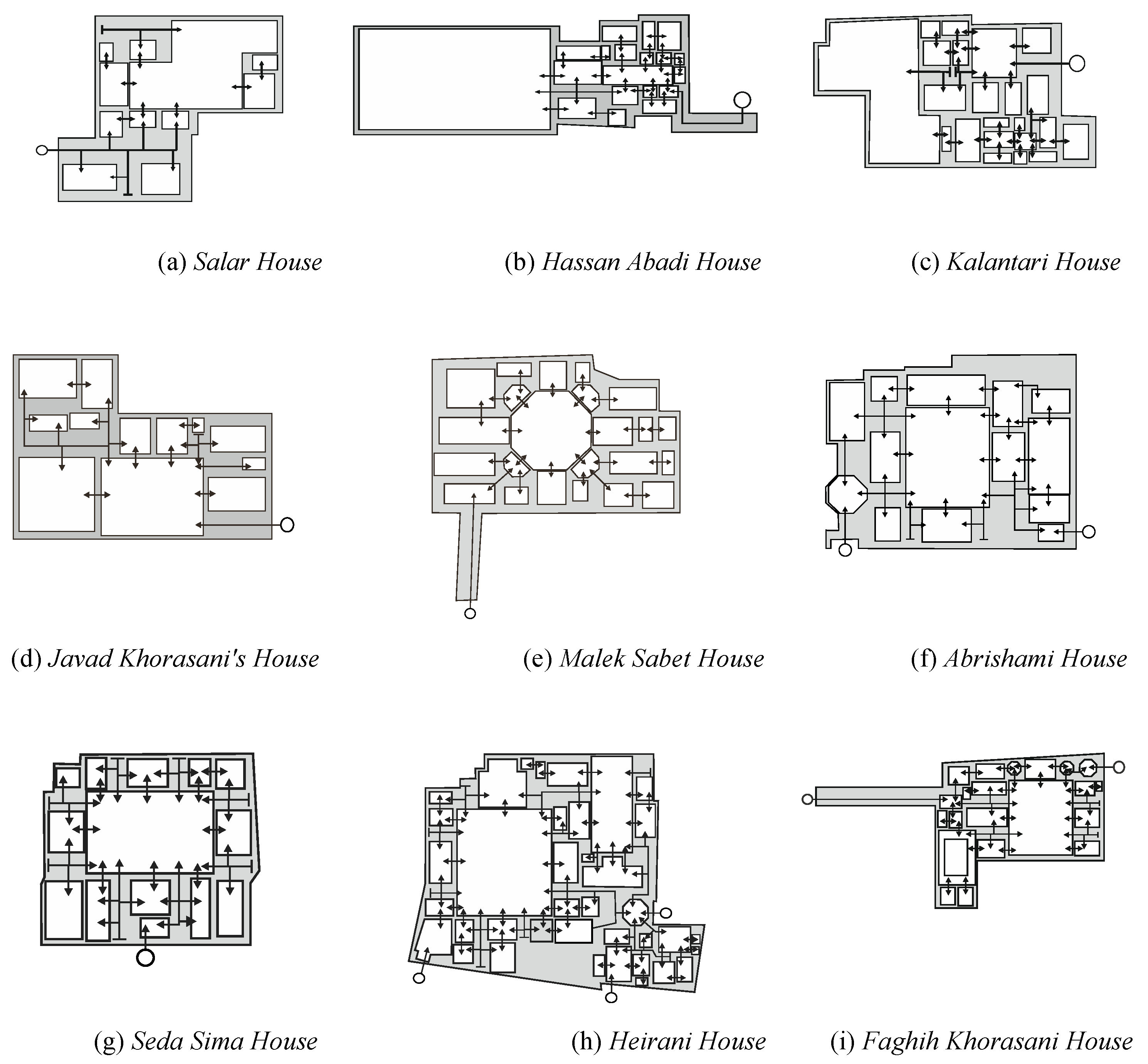
6] (
Figure 1). In reality, though, these types are not mutually exclusive. For example, one of the most famous types of platform houses, pre-dating the Seljuk and Timurid eras, has a four-platform plan with a central courtyard. It has been argued that this plan was originally Zoroastrian and was later adapted in post-Islamic Iran to provide a clear hierarchy of spaces around a central courtyard, with a perimeter of semi-open spaces and then a series of fully enclosed spaces [
19]. As such, many platform and garden houses feature courtyards, although they do not necessarily conform to all characteristics of courtyard houses. In the present paper, one of the 37 cases examined (Vizier’s House) conforms to both the courtyard house and platform (
chahar soffeh) house types and its inclusion reflects this dual categorization.
Past research has tended to explain the spatial planning of the Yazd courtyard house using either climatic responsiveness or socio-religious reasoning, and it is clear that both factors partially explain the planning of these buildings. For example, Adeli and Abbasi Harofteh [
20] argue that the combination of open yards and enclosed rooms is an appropriate response to the hot and dry climate of Yazd. The cruciform pattern with a central courtyard is ideal for “seasonal relocation”, as it has summer-living (northeast) and winter-living (southwest) zones [
21]. Moreover, the courtyards are often angled so that half the interior spaces capture the sun in the colder parts of the year and are shaded in the hotter months. In a study of three Yazd houses, for example, Soflaei, Shokouhian and Soflaei [
22] identify a consistent orientation and proportion for the courtyards to achieve this outcome. In a study of ten Yazd courtyard houses, Khajehzadeh, Vale and Yavari (p. 481, [
3]) conclude that the courtyards were designed “on the basis of receiving sunshine for some internal facades on cold winter days and sufficient shade on others for hot summer days”. Conversely, historians have argued that residential planning is designed primarily to achieve privacy and to emphasize spatial hierarchy through separation of spaces by courtyards and corridors. The courtyard symbolized the centrality and unity of the reception and living spaces, with axial family spaces and perimeter service spaces reinforcing the hierarchical structure [
12].
Architectural planning is both a reflection of the needs of the society that created it, and a mechanism which shapes the way a society functions [
23]. In addition to the dominant socio-cultural and environmental paradigms for explaining the planning of the Yazd courtyard house, there are also multiple pragmatic factors involved [
1,
6,
18]. These houses were multi-generational residences, with different zones for the family’s oldest members, their children and spouses and finally their grand-children. As such, the Yazd courtyard house often accommodated multiple extended families. In addition, large families often had servants, creating the need for more extensive networks of rooms and spaces for work and living. The multiplicity of courtyards and perimeter rooms accommodated a similarly diverse range of domestic, agricultural and even industrial practices, providing food, materials and products for the household to use, sell or trade. Some rooms and courtyards would have functioned as stables for horses or livestock, and a room was often set aside for cotton and silk weaving. Furthermore, in traditional Iranian culture, houses of this type served to ensure privacy and safety for both families and their guests. In the latter case, the vestibule at the entrance of the house was a zone of separation, between the public and private realms. The vestibule commonly contained links to guest quarters, providing a welcoming space, and also delineating their rooms from family and service areas [
5].
While rooms in these houses were not “functionally defined” (in the sense that their use changed to adapt to climate and the needs of the extended family), there were some consistent factors. Many main courtyards were paved and used for family celebrations, rituals and events. Some courtyards were designed for a single function and were located in the plan for a specific purpose, say, adjacent to a guest room, or alternatively as a space for animals. Others would have contained vegetable gardens and ponds. As these houses had few conventional windows, the courtyards were the primary means of accessing light, sun, air and views. The rooms that surrounded the courtyards would have had indirect access to natural light and ventilation through the roof opening. These spaces would have included both semi-public (guests and family) and semi-private (family) functions, depending on the seasons. In the next layer of rooms, which are two steps removed from natural light and air, there would have been kitchens, vestibules, entrances, stables and bathrooms. Because the rooms in these houses often had multiple doors, they would have functioned in part as habitable spaces and also as passageways to navigate around the house. This spatial separation, which required people to pass through a matrix of rooms, would have been the main way of shaping and controlling the relationships between, and conflicting spatial needs of, children, family members and guests [
2].
Throughout the latter part of the 20th CE century, much of this changed. Growing industrialization led to a rapid urban growth, overcrowding and pollution in many historic cities, including Yazd. In response, the affluent and middle-class of Yazdi society gradually abandoned the historical core of the city and relocated to the suburbs. Today, some of the larger historic courtyard houses have been converted into government offices, and medium-sized houses have become cultural centers, restaurants and hotels. The smallest houses are often still residences today, where they are typically inhabited by low-to-middle income families.
This background to the Yazd courtyard house highlights common interpretations of this building type and practical dimensions. Within this large topic area, the present paper is concerned with three gaps in our knowledge which recur throughout much of the past research. First, despite evidence to the contrary, it would be possible to read past research without knowing that houses of this type typically have multiple courtyards, not all of which have the same orientation or proportion [
19,
20,
21]. They also vary significantly in scale (number of rooms) and complexity (spatial hierarchy) [
12,
13,
14]. Second, there is a tendency in past research to treat the planning of these houses as largely unchanging over time [
20,
21]. Third, past research overwhelmingly describes these buildings as having a relatively consistent planning pattern [
2,
4]. This paper begins the process of understanding these three gaps in our knowledge, which in turn have an impact on the dominant environmental and socio-cultural interpretations of this historic building type.
3. Method and Measures
First developed in the 1980s, Space Syntax is a set of theories, methods and techniques for mathematically measuring and comparing the spatial or spatio-visual properties of a building [
10,
23]. This approach is grounded in the view that the spatial properties of architectural plans are significant because they both reflect and reinforce the dominant social relationships, hierarchies and controls of a building type, society or era [
8,
24,
25]. Logically, Hillier argues, “a spatial layout can reflect and embody a social pattern” and in parallel, “space can also shape a social pattern” (p. 104, [
8]). Ostwald and Dawes propose that “such a pattern serves to enshrine the collective social structures and values of a group in the spatial configuration of buildings which have been designed to accommodate them” (p. 24, [
9]).
With a focus solely on spatial properties, Space Syntax was the catalyst for a paradigm shift in architectural analysis, rejecting the standard conventions which sought to understand architecture in terms of formal properties (shape), style (aesthetics) and geography (orientation and context). Instead, Space Syntax reasoning proposed an understanding of architecture that is inherently spatial, relational and topological. Conceptually, Space Syntax suggests that for understanding the ways people inhabit, cognitively process and behave in space, plans are more significant than elevations.
A further important aspect of Space Syntax theory is that it maintains that, logically and mathematically, the topologically central spaces in a plan are more likely to be experienced than those at the periphery of a plan. To frame this another way, “central” spaces offer greater opportunity for social interaction and co-presence than peripheral ones. This is not saying that heightened social interaction will only occur in central spaces, or that peripheral spaces will be empty. It does suggest, however, that the activities that happen over time, and which multiple people engage in, will tend to occur in the more spatially integrated rooms. Thus, Space Syntax models the statistical or mathematical properties of spaces, which have been shown to correlate to patterns in human behavior [
6,
7,
8,
9].
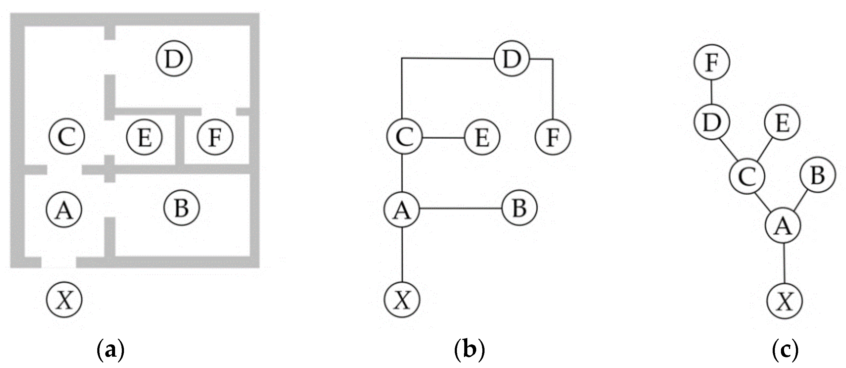
One of the most well-known Space Syntax techniques is Convex Space analysis, which is also known as Justified Plan Graph analysis [
26]. This method commences by identifying the main visually or functionally defined spaces in a plan and the connections between them. The “permeability”—capacity to move—relationships between these spaces are then analyzed using graph theory [
10,
27]. This requires converting the spaces in the plan into the nodes of a graph, and connections between these spaces into edges in the graph (
Figure 2). The base of the graph or “carrier” is then chosen to reflect the property being examined. In most cases, this is the exterior, as it is significant for understanding or studying privacy, access and control.
Once the graph for each plan is developed, then seven primary topological measures can be derived from it for each node (or room), generating measures for the complete graph (or building) and two additional measures can then be developed from each graph. Furthermore, using these nine measures, comparisons can be undertaken between sets of houses to reveal their planning structures and how they vary by region or over time [
10,
27]. Detailed descriptions, formulas and worked examples for all of these standard measures are widely available [
10,
26,
28,
29] and the key mathematical and interpretive principles are summarized hereafter.
3.1. Total Depth (TD)
TD is the sum of the connections between a given node in the graph and every other node, weighted by depth. This is, in practical terms, an indication of the distance between a room and every other room in a plan.
3.2. Mean Depth (MD)
MD is the average depth of a node in a graph, where
K is the complete number of nodes (the denominator is
K–1, because it excludes the node being measured). A room that is higher than the mean for a plan is more spatially isolated than one which is lower than the mean.
3.3. Relative Asymmetry (RA) and Integration (iRA)
RA is a measure of the relative isolation of a node within the graph, and its inverse is
i(RA), which is the level of integration of a node. Simplistically, more integrated spaces are more public and people will be more likely to meet one another in these spaces. Less integrated spaces are more private or have reduced likelihood of being sites of random encounters.
RA is also important because it allows a researcher to compare measures derived from similar size graphs by normalizing
MD to a range between 0.0 and 1.0.
3.4. Real Relative Asymmetry (RRA) and Integration (iRRA)
Because graph values are relative to the number of nodes and their distribution, to undertake a comparison between different sized graphs (building plans with different numbers of rooms),
RRA normalizes the measures relative to an idealized diamond-graph
D, for
K number of spaces [
23,
24]. Once
RRA is determined, a normalized integration (
iRRA) measure can also be developed for comparing properties of different sized graphs. It must be noted that there is disagreement in past research about the relative merits of
RRA verses
RA, with both being normalized, albeit in different ways. For this reason, some past research reports one of the other pair of results, whereas other researchers report both and use them as complimentary data sets, which may reinforce a key message [
26,
28]. In this paper, both are reported as part of a comprehensive review of the results. For a detailed review of the merits of both approaches and their interpretation, see [
26].
3.5. Control Value (CV)
CV is a measure of the extent to which one node influences all others. It has also been described by Klarqvist as “a dynamic local measure” that defines “the degree to which a space controls access to its immediate neighbours” (p. 11, [
28]). In practical terms, it can be used to identify the spaces in a plan that will tend to be “sites of attraction” or have “pulling potential or capacity” (p. 63, [
8]). The
CV of a node
a (and where
Val(
b) is the number of connections to node
b) is determined using the following formula.
3.6. Unrelativized Difference Factor (H) and Relativized Difference Factor (H *)
Once the seven topological measures are developed for each room, the mean properties of an entire plan can be determined. Two important properties are
H and
H*. The logic for these measures is derived from Shannon’s
H-Measure and resultant entropy calculations, and they are used to interpret whether a plan is ordered or deliberate, as opposed to random or disordered [
10,
28].
Hanson describes
H as measuring the “spread or degree of configurational differentiation across a set of integration values” (p. 30, [
9]).
H is calculated using the maximum (
a), mean (
b) and minimum (
c)
RAs in the graph, the sum of which is (
t). For
H*, the formula uses natural logarithm to base
e (ln).
4. Application
In this paper, plan graph analysis is used to measure the topological properties of the plans of 37 historic houses, from six eras (Seljuk-Atabakan, Ilkhanid-Al-Muzaffar, Safavieh, Zandieh and Afshari, Qajar and Pahlavi). This section describes the case selection approach and the methodological application.
4.1. Case Selection
Past research about the socio-cultural and environmental properties of Yazd courtyard houses has typically been based on an assessment of just one or two cases [
21], and it is rare to see as many as 10 cases in such a study [
3]. While different approaches and methods call for different numbers of cases, past research emphasizes that it is not possible to develop a statistically significant “sample” of Yazd courtyard houses, relative to the total “population” of these cases. There are multiple reasons for this, including a relative paucity of cases that have not been extensively modified in the past, and the fact that these houses are, for the most part, privately owned and inaccessible to scholars.
Knowing that a statistically significant sample cannot be established, the conventional approach used by scholars is a variation of the “snow-balling” strategy, wherein the cases studied in past research are selected as being significant for future research. In contrast, the present paper adopts a purposive approach, using the archives and surveys of the Yazd Cultural Heritage Organization (YCHO) as a starting point. The buildings identified by YCHO, and which make up the set studied in this paper, have four significant properties.
They are largely in original condition, not having been extensively adapted and modified over time.
Their urban contexts are not significantly degraded by modern development or other factors such as natural disasters.
They have been pre-classified by experts into different planning types: four-row, platform, garden-villa, central courtyard.
They are exemplars of the era in which they were designed and built.
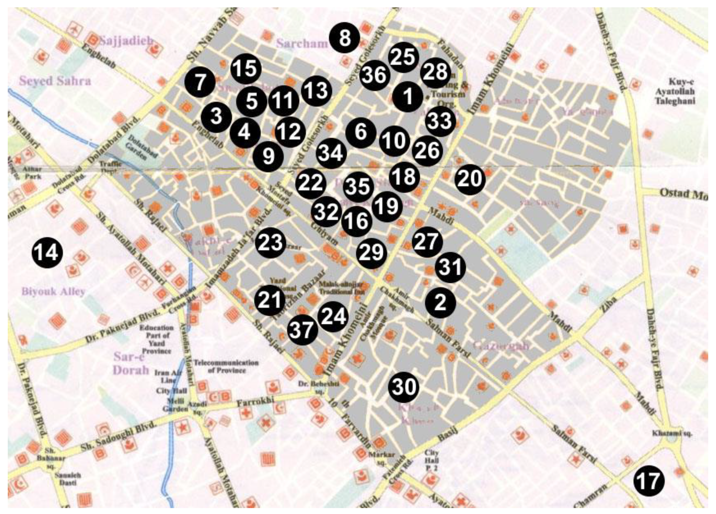
Using the YCHO’s parameters for determining significant works, the number of cases available across the time period and in the particular planning type (“courtyard house”), is 37 (
Figure 3,
Table 1). Focusing just on the set of courtyard houses documented by the YCHO, the cases span from the Seljuk-Atabakan to the Pahlavi eras. There are few documented courtyard houses which pre-date the earlier of these eras and none which match the criteria. The Pahlavi period extends across the first half of the 20th century, when relatively traditional methods and approaches were still in use. By the latter part of the 20th century, however, this changed, and cases could not be legitimately regarded as reflecting the traditional building type.
4.2. Methodological Approach
It is not surprising, given the widespread application of Space Syntax methods, that they have previously been used to investigate the properties of Iranian housing [
30,
31], including selected aspects of Yazd courtyard housing, which have often been used to support claims about environmental and socio-cultural properties [
6,
7]. All of these past applications of syntactical methods have used the entrance as carrier, which produces data for examining overarching public–private or visitor–inhabitant relationships. For the present paper, in order to isolate and measure the properties of the plans relative to their courtyards, the courtyards are used as the carriers.
Six steps were followed to develop the data for this paper.
The floor plans for each of the 37 YCHO-classified houses are coded and annotated to differentiate “open” (to the sky) and “closed” (enclosed by walls and roofed) spaces.
Spaces are “functionally” defined, rather than in accordance with formal convex space conventions. The connections between spaces (doors, non-habitable annexes and short corridors) are annotated as lines with arrows.
A grading map is developed, identifying the topological “step-distance” between rooms and yards (courtyards = 0, one step removed from a yard = 1, two steps removed from a yard = 2, etc.). Thus, courtyards are grade 0, perimeter spaces are grade 1, with deeper spaces graded 2 or higher. Multiple spaces at the same level of depth are numbered for identification purposes (2.1, 2.2, 2.3, etc.). This grading is not only a topological property, but it reflects the value and status of rooms. Historically, valuable living spaces were assumed to be closest to the courtyards and conversely, service areas such as kitchens, stables and bathrooms were more distant. This also reflects the “privacy gradient theory” of spatial organization [
9]. Importantly, for the majority of environmental performance-related interpretations of these houses, depth of rooms from courtyards is a core consideration.
For each room in each house, seven measures—
TD,
MD,
RA,
i(RA),
RRA,
i(RRA),
CV—are developed using Agraph software [
32].
For each house, four additional measures—H, H*, means based on the number of spaces in the house (K) and the number of spaces at each grade—are developed.
Longitudinal graphs are produced of the mean measures and mean grades over time, and trendlines are generated from these (“least-boxes” method) to support interpretation of the data.
Agraph [
32], from the Norwegian University of Science and Technology (Norges teknisk-naturvitenskapelige universitet), is a common software package for plan graph analysis in architecture. It does differ from DepthMap, the other common plan graph analysis software, in several ways, including its calculations for some metrics and the way it handles rounding-errors, irrational numbers and reporting. For example, one reporting issue arises from compounded rounding errors using averages of mean results. Issues of this type are common in software programs for this purpose, and they do result in anomalies in the data. Such variations and issues are discussed in [
26]. For example, a “methodological problem occurs when the total depth of a node equals the number of rooms minus one” (p. 468, [
26]), because it is not possible to calculate the reciprocal of an inverse number. This mathematical problem would not occur in hierarchical or arborescent plans, but could occur in shallow, rhizomorphous plans. While Yazd courtyard houses are not shallow in a conventional planning sense, when measured relative to the topology of the courtyard, they can be extremely shallow, resulting in this irrational number problem.
4.3. Methodological Example
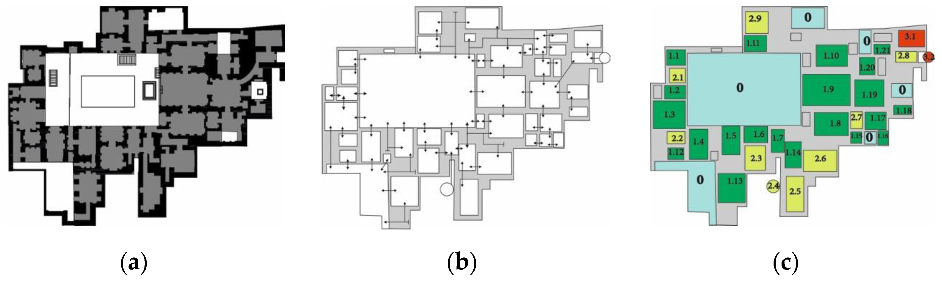
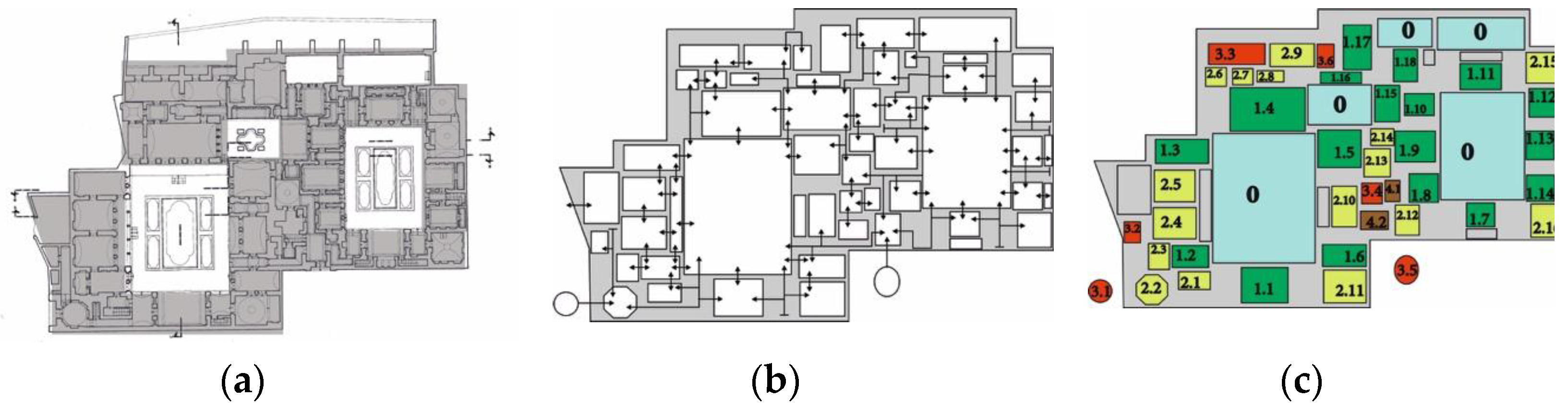
Examples of the application of these six steps are provided for the Tagh Bolandha House (
Figure 4a–c and
Table 2) from the Seljuk-Atabakan period and the Golshan House (
Figure 5a–c and
Table 3) from the Qajar period. For each house, every room is converted into a graph node. For each node, seven measures are produced:
TD, MD, RA, i, RRA, iRRA and
CV. For example, consider node 1.9 in the Tagh Bolandha House, a large space to the center-right of the biggest courtyard. This node’s
TD = 68,
MD = 2.13,
RA = 0.07,
RRA = 0.42
, and
CV = 0.99. Although considering the properties of a single room in this plan would not be a standard way of reading the results, it can be undertaken by comparing these values with the means for the entire plan. For example, the large room designated as node 1.9 is less deep than average (
μ TD = 79.39), and it is therefore more accessible than other rooms. Its topological “step distance” from a courtyard is close to average (
μ MD = 2.48), and it is slightly more integrated (
μ i = 12.09) than an average room in the house. A close review of the plans reveals that this room is not only directly connected to one courtyard, but it requires only one additional connection to access two more courtyards (by way of nodes 1.10 and 1.19). The existence of such a room poses a challenge for two of the hypotheses that are tested in this paper, although it would only be a significant challenge if multiple rooms with similar properties existed in other plans of this architectural type.
A detailed mixed-method, qualitative and quantitative analysis of the properties of the entire plan of the Tagh Bolandha House can be undertaken in this way, although it is more common to develop rank-order lists of different room types (known as an “inequality genotype”) to capture larger patterns in the planning. With the complete set of data for each house available, two further measures can be derived for the Tagh Bolandha House:
H = 0.86 and
H* = 0.41. These results indicate that the plan has broadly homogenized properties relative to the courtyard locations, with a tight cluster of integration values [
8]. Superficially at least, this implies that there is only a very loose spatial matrix of rhizomorphous structure to the plan, without a high level of control or social hierarchy, relative to the location of the courtyards [
24,
27].
5. Hypotheses
The three knowledge gaps identified in the introduction and literature review are reframed in this section as hypotheses, which are then aligned to testing conditions. These are not hypotheses in a scientific sense, rather, they are conversions of implicit assumptions into mathematically testable forms. These hypotheses are as follows
Hypothesis 1 (H1). Yazd courtyard houses typically have a single courtyard and have similar total numbers of spaces.
The first part of this hypothesis would be supported by the data if μ KG0 < 1.3. The 1.3 value, while artificial, would allow a small number of houses to have a secondary courtyard, which would not impact the results of past research. If, however, μ KG0 > 1.3, then assumptions about the role of the (singular) courtyard in this planning type would need to be revisited. For the second part of this hypothesis, if SD of K is > 25% of μ K, then assumptions in past research about the consistent size of courtyard houses may need to be revised. Because no absolute metric is available, the 25% is an artificial indicator to accommodate some variance in the data around an otherwise clustered result.
Hypothesis 2 (H2). Theplanning of Yazd courtyard houses is largely unchanged over time.
This would be supported if longitudinal trendlines generated from TD, MD, RA and CV are flat/level and the SDs of these measures are less than 25% of the mean in each case.
Hypothesis 3 (H3). Yazd courtyard houses exhibit a clear pattern of planning relative to the courtyard.
There are three possible ways to test this claim. First, this type of consistency could be evident in the ratio of KG0/KG1/KG2-4 (courtyards to perimeter rooms to higher gradient rooms). Second, trendlines for RRA (which is normalized to accommodate different size graphs) and CV could reveal a pattern that operates regardless of scale. Third, H can be used to determine if there is any evidence of intent in the planning. If μ H < 0.5, the planning is highly deliberate or distinctive.
6. Results and Discussion
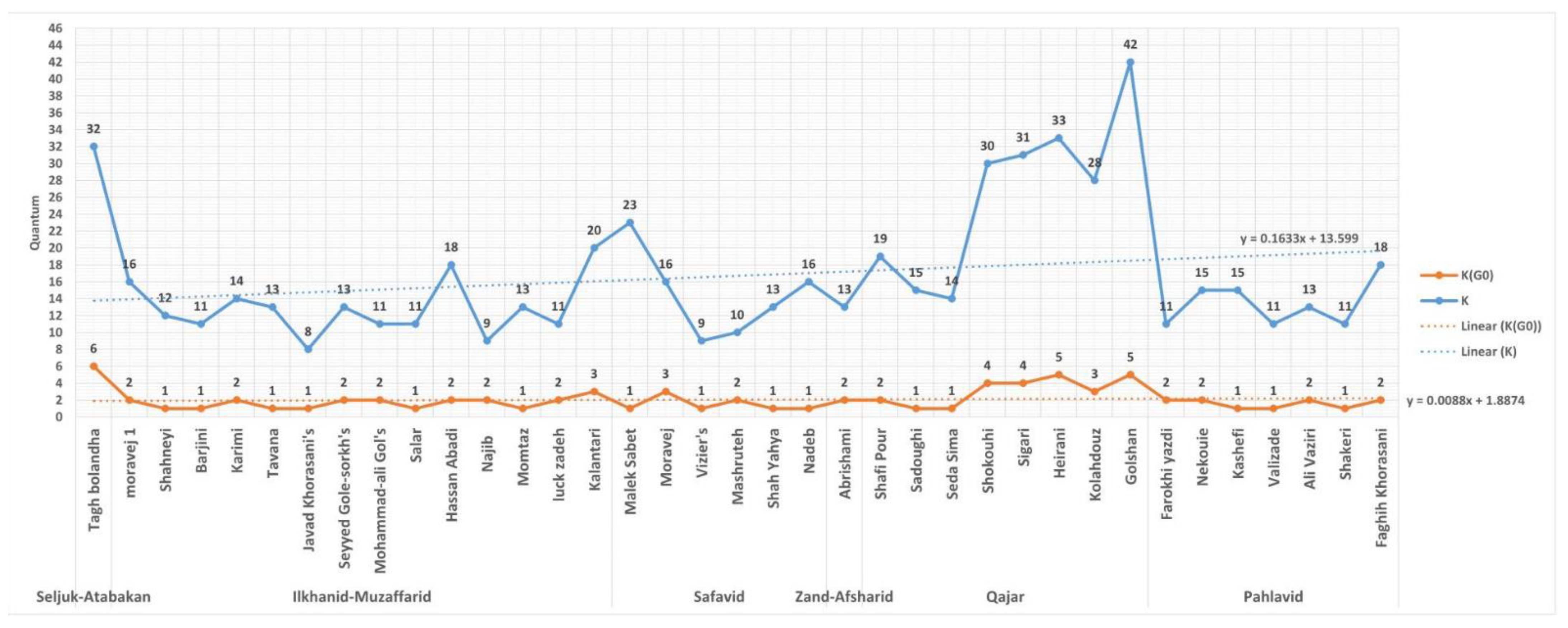
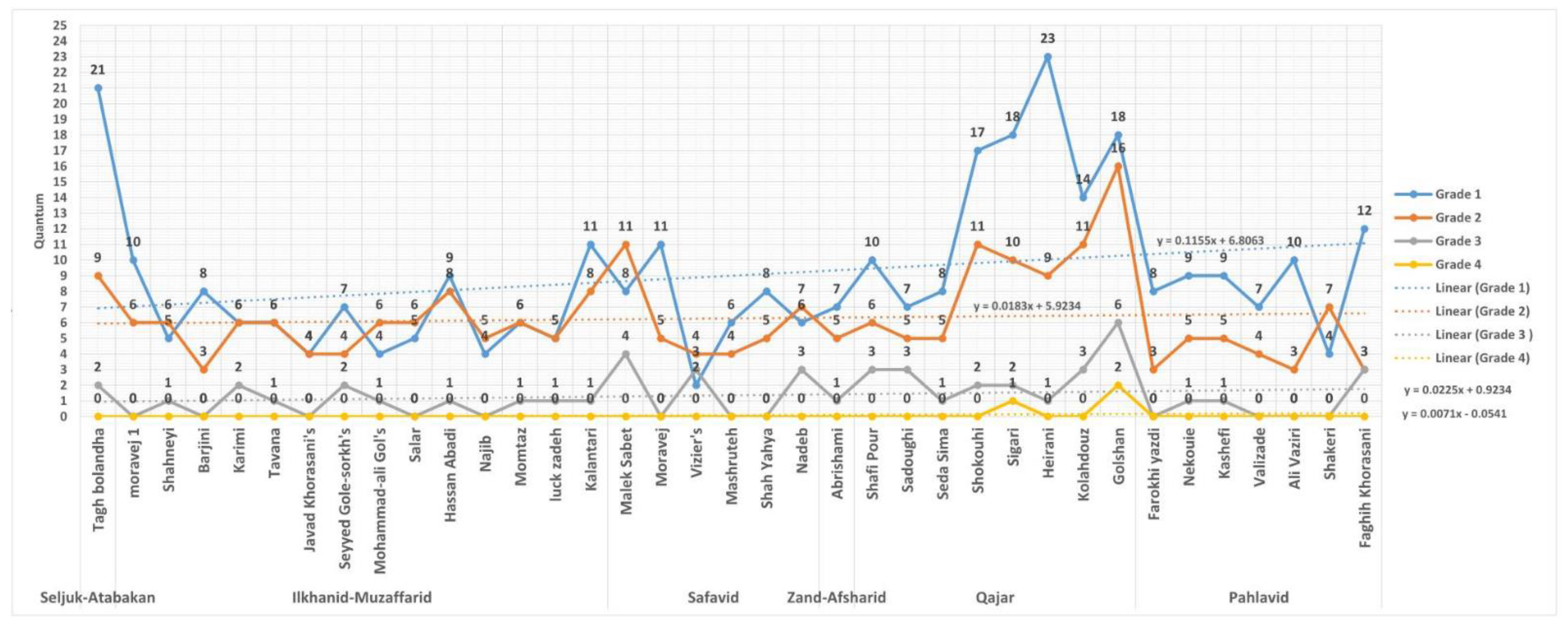
The number of rooms (
K) and the number of courtyards (
KG0) in each house are charted chronologically (
Figure 6), as too are the number of rooms at different gradients of depths from the courtyards (
KG1-4) (
Figure 7). The mean number of enclosed rooms in each house in the set is 16.70, the mean number of courtyards is 2.05 and the standard deviation for
K is 7.99 (47% of
μK). The largest house, in terms of room numbers, is the Golshan House (
K = 42) and the smallest is Javad Khorasani’s House (
K = 8). The number of courtyards is highest in the Tagh bolandha House (
KG0 = 6) and only six houses have a single courtyard (Salar, Javad Khorasani’s, Malek Sabet, Vizier’s, Seda Sima and Valizade). When the data are analyzed chronologically, a slight rise in
K over time is visible (largely due to the data for the Qajar period), while the trendline for number of courtyards (
KG0) is level (
Figure 6). Trendlines for perimeter rooms (
KG1) also rise slightly over time, whereas for deeper rooms (
KG2-4) the trend is largely flat (
Figure 7).
The ratio of courtyards (μ = 2.05), to perimeter rooms (μ = 9.00), to second gradient rooms (μ = 6.27), is 1/4.30/3.05. Despite these mean figures, the ratio of courtyards to the total number of rooms is less constant. For example, in both the Tagh Bolandha House and the Moravej House, this ratio is 1/5.3, even though the two are very different sizes. In the Golshan House the ratio is 1/8.4 and in the Salar House it is 1/11, confirming that, despite some clustering in the data, the ratio may be evolving over time.
The syntactical results for each house are presented in
Table 4, and the mean results for each period are in
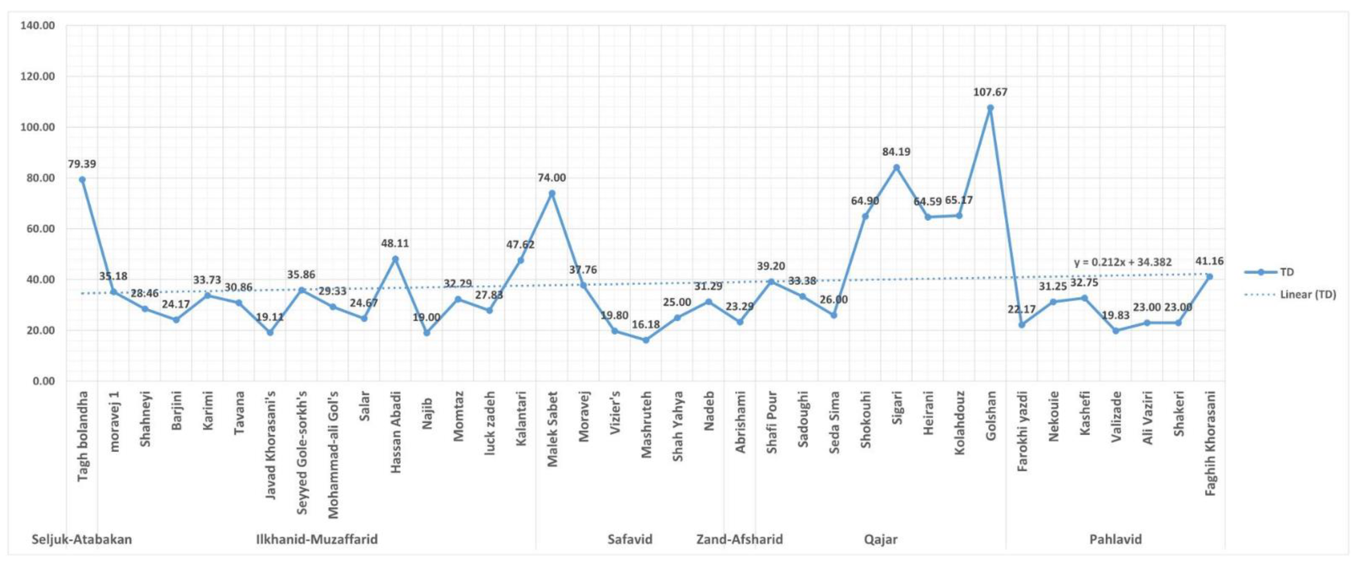
Table 5. The topological depth data indicate a marginal rise in
TD (
Figure 8) and a decrease in
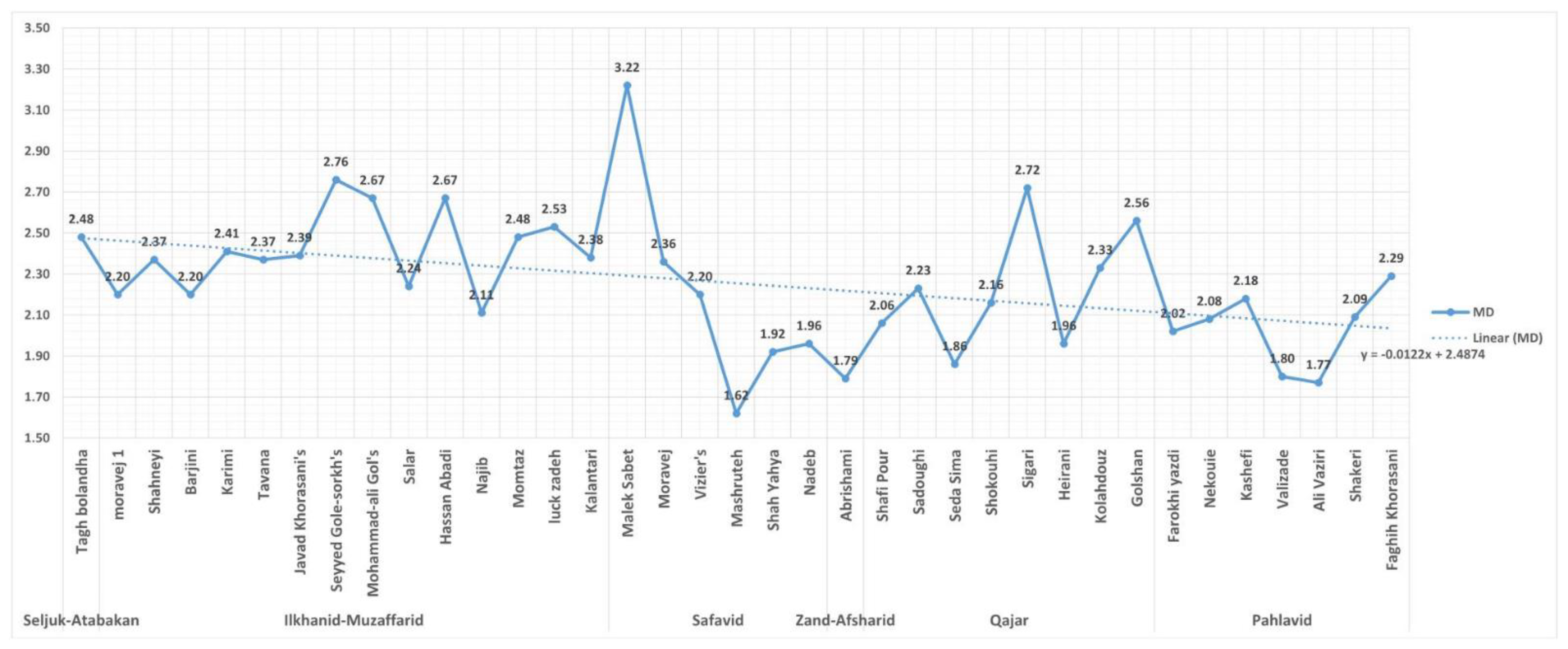
MD (
Figure 9) over time. As
K is rising (
Figure 6), it might be assumed that a parallel rise in
TD would occur, but this is not the case. Logically, the inclusion of additional courtyards, coupled with planning that clusters rooms around these yards, could be responsible for the trends in both
TD and
MD. This interpretation is supported by the gradient data, where the number of
KG3 and
KG4 rooms remains very low regardless of the total house size (
Figure 7).
The highest
RA and
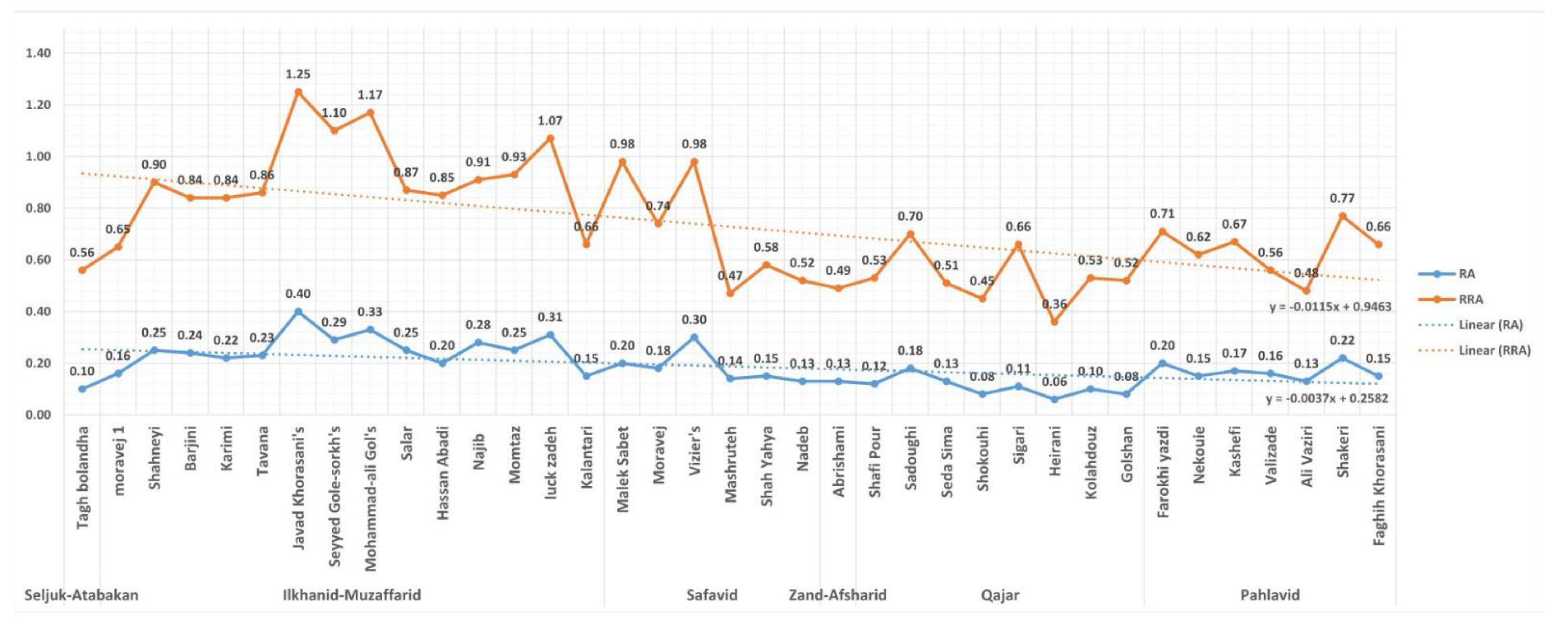
RRA (
Figure 10) values are in the data for Javad Khorasani’s House (Ilkhanid period) at 1.25 and 0.4, respectively, and the lowest are in Heirani House (Qajar period) at 0.06 and 0.36, respectively. Interestingly, the normalized
RRA results for the two are similar (0.4 verses 0.36), which may reflect the similar ratio of courtyards to rooms identified previously (
KG0/
K). The difference in results between the smallest and largest values is relatively pronounced, and with the increase in scale, rooms become less private, because the addition of further yards produces more perimeter spaces, which are higher integration zones. On average, over time, spaces have become more integrated around the courtyards and arguably, privacy has been reduced because of this. This might reflect a simplification of environmental design strategy over time, as well, with deeper rooms being less important.
Results for mean
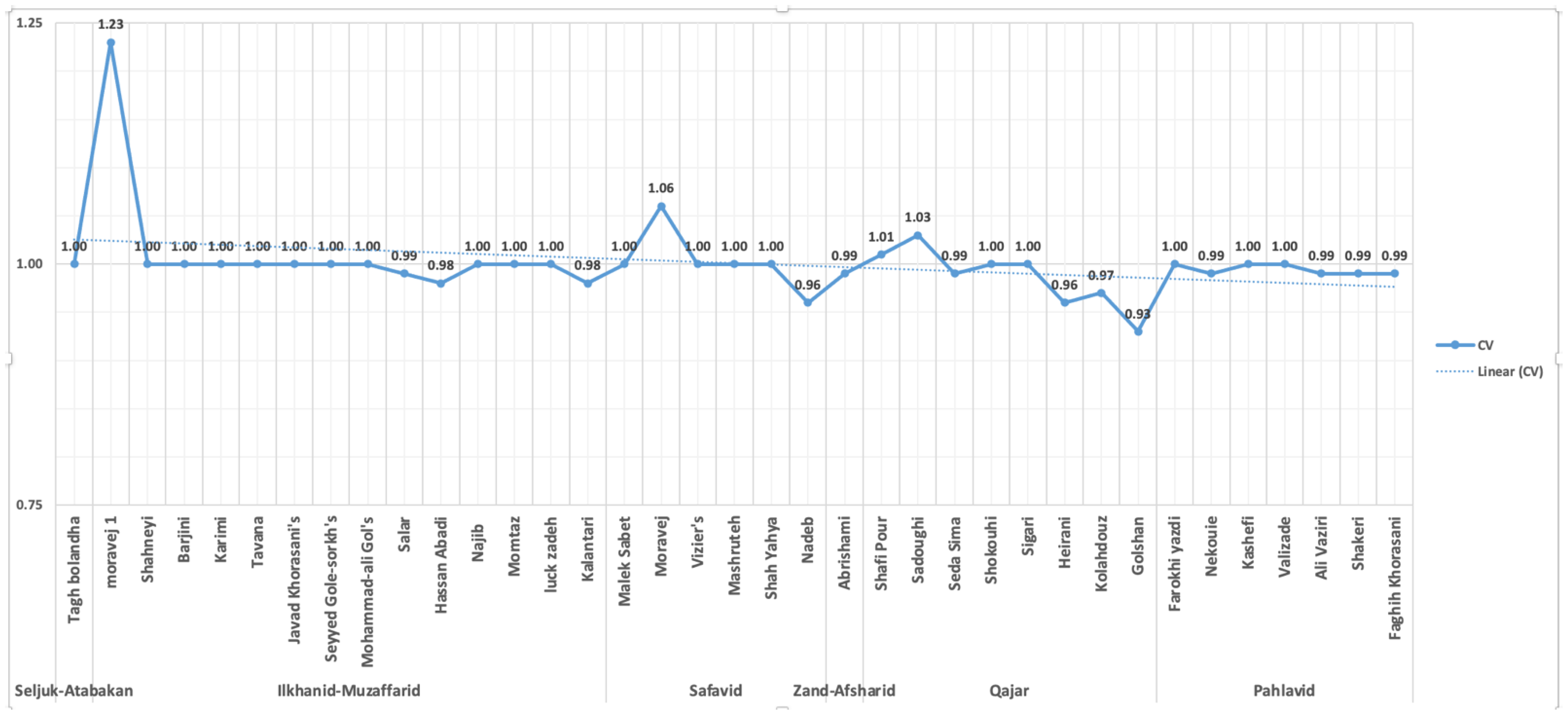
CV for each house may indicate that a pattern exists in their planning. Not only is the trendline relatively flat, but the
SD/
μ × 100 for CV is 4%, which indicates a tightly clustered set of data, with only a few statistical outliers (
Figure 11). The primary outliers are the Moravej 1 House, Moravej House and the Golshan House.
Difference Factor (
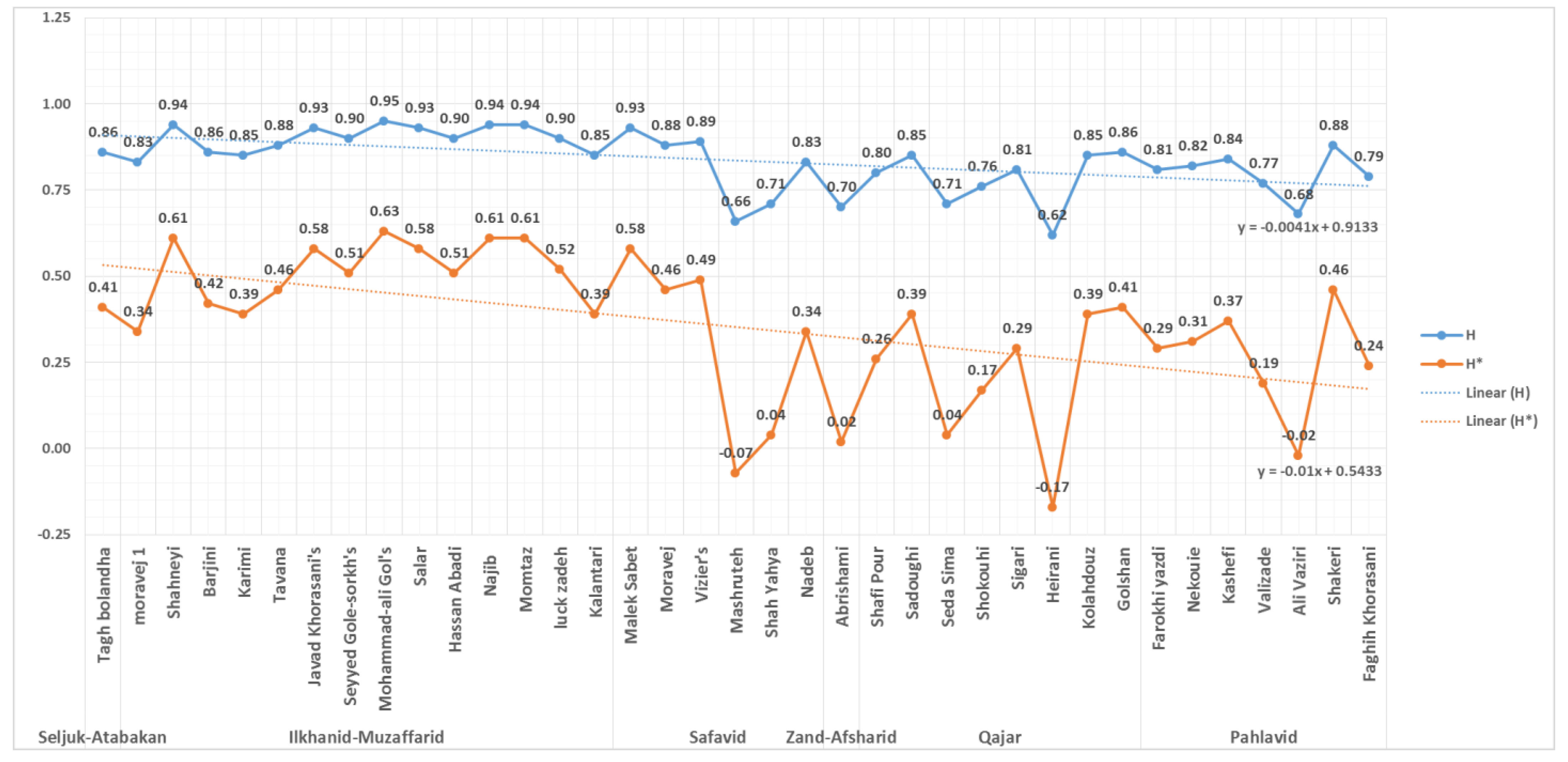
H) provides an indication of the degree to which the spatial distribution of rooms in a plan, relative to the position of the yard, is more or less deliberate or distinctive. An
H result close to 0 would infer a high level of specificity or hierarchy in a plan, whereas a result closer to 1 might suggest a more generic and undifferentiated set of spatial relations in the plan. The mean for
H across the set is 0.84 (
Table 4) and the trendline marginally reduces over time (
Figure 12), which confirms that there is a degree of homogeneity in the planning.
7. Conclusions
Using a variation of the Space Syntax plan graph analysis method, justified by courtyard location, this paper set out to examine three hypotheses about the planning of the Yazd courtyard house. Before reviewing the results, it is important to reiterate two limitations. The method chosen for this paper can only be used to directly comment on the topological properties of the architectural plan, which in turn may have indirect consequences for socio-cultural or climatic interpretations of the function of these houses. Furthermore, the particular software application resulted in some anomalous results and compounded rounding errors, which do occur when dealing with highly connected, matrix-style plans, and cannot easily be resolved. The use of the courtyard as carrier for the graph, while both original and appropriate, was responsible for some of these anomalies, and a future study will use a more conventional external carrier for a parallel analysis. The results for each hypothesis are as follows.
H1. Yazd courtyard houses typically have a single courtyard and similar total numbers of spaces. The data do not support the first part of this hypothesis, as μ KG0 = 2.05. On average, the exemplar Yazd courtyard houses have two or more courtyards, with a maximum of six. For the second part, the data do not support this hypothesis, as the standard deviation for K is 7.99 (47% of μK) and the houses range from 8 to 42 rooms. Notwithstanding this diversity, their size is, on average, increasing over time.
H2.The planning of Yazd courtyard houses is largely unchanged over time. Despite trendlines for TD being relatively level, SD/μ for TD is 55%, confirming a high level of variation. The trendlines for MD and RA are both falling and standard deviations emphasize the diversity in some (SD/μ for RA = 42%), but not all (SD/μ for MD = 15%) aspects of the data. Nevertheless, the data suggest that spatial hierarchy and depth (TD and MD), and integration and separation (public verses private, i and RA) have all gradually changed over time. In addition, despite the plans increasing in both size and complexity, the houses have become less private or spatially isolated.
H3. Yazd courtyard houses exhibit a clear pattern of planning relative to the courtyard. This hypothesis is about patterns in the frequency and topological location of the courtyard in the architectural plan. The result for this hypothesis is partially supported, although there is a need for future research to confirm this. Three sets of data are used for this analysis: (i) the ratio
KG0/
KG1/
KG2-4, (ii) trendlines for
RRA and CV, and (iii)
μ H. The
KG0/
KG1/
KG2- ratio in the data is 1/4.30/3.05 and, despite variations, there are multiple cases that cluster around this ratio. One implication of this result might be that changes in the number of rooms in a house were accommodated in the plan through the addition of further courtyards. Alternatively, over time, the practical importance of having a single, central courtyard may have been reduced, possibly as a reflection of economic changes, increased migration and urbanization rather than changing environmental conditions. The trendline for
RRA reinforces this reading. Thus, despite a growth in
K over time, and a parallel reduction in normalized levels of isolation of a node within the graph (
RRA), the normalized integration is relatively stable. In terms of spatio-structural complexity, a loose pattern may well exist around the ratio of yards to rooms. The final indicator,
μ H = 0.84, suggests that these 37 plans only possess a low level of spatial differentiation or deliberation. Such a finding would make sense for a building type that has a completely flexible or rhizomorphous spatial arrangement to accommodate seasonal adaption. Indeed, this approach was also common in some Renaissance European villas, and seasonal adaption has recently been tested for the first time using plan graph analysis of Palladian villas [
33]. The
μ H results for Palladian villas are even higher (more flexible or less distinctive) than for the Yazd courtyard houses.
These findings may pose challenges for two of the foundation assumptions in past research about the architectural planning of the Yazd courtyard house (
Table 6). The first hypothesis should, in hindsight, not have needed detailed analysis, as a cursory review of archived plans and surveys for this architectural type clearly shows diversity of size and the presence of a number of courtyards in these houses. Certainly, some of the houses that are more commonly studied in the literature have either a single courtyard, or a major courtyard coupled with a minor or secondary one. This is not, however, the standard across the exemplar works, and often two or more courtyards are of similar size and have different orientations. While the orientation and scale of courtyards are not further considered in this topological approach, the results have implications for the classic environmental interpretation of the planning of these houses. The focus on a single courtyard is clearly a limitation of some research; however, the present study suggests that all courtyards might serve the type of environmental role postulated in past research.
The second hypothesis confirms that not only has this planning type changed over time, but it has evolved in interesting ways. For example, the Ilkhanid period (1256–1335 CE, 651–736 AH) has the highest RRA, RA, MD and CV results. The houses of this period were more hierarchical, segregated or isolated and controlled. In contrast, the Qajar period (1781–1925 CE, 1195–1344 AH) had the highest levels of spatial accessibility or permeability (reflected in i). Indeed, the data identify the Ilkhanid and Qajar periods as having quite divergent social (and possibly cultural or political) conditions. This result has implications for the classic environmental interpretation of these houses, as the depth of rooms around courtyards has decreased over time. This would appear to signal the need for further environmental modelling and consideration using longitudinal data. Conversely, the dominant socio-cultural interpretation of spaces in these houses suggests that they may be becoming less private, a position with some support in the paper.
The findings of the final hypothesis are perhaps the most significant. A traditional, hierarchical or arborescent spatial planning pattern around courtyards was not identified in the data. Instead, there is an almost cellular growth pattern, wherein as houses became larger, additional courtyards and perimeter rooms were included in a rich matrix of spaces. This limited the mean depth and isolation of rooms, and maintained a relatively consistent relationship between the number of courtyards, perimeter rooms and second gradient rooms. This would not, however, have reduced the spatial complexity, or the cognitive complexity of navigating around and using these houses [
34]. There are also exceptions to this pattern. For example, it was mentioned previously in this paper that Vizier’s House from the Safavid period could be considered both a courtyard and a four-platform house. Vizier’s House is a statistical outlier in the data for hypothesis 3, suggesting that it might not be classified as a courtyard house at all. This case highlights the usefulness of this analysis approach, not only for testing hypotheses, but also for classifying different works. This capacity could be investigated in future research.


