Article

Countermeasures of Double Carbon Targets in Beijing–Tianjin–Hebei Region by Using Grey Model

1
College of Economics and Management, Hebei University of Technology, Tianjin 300401, China
2
College of Management Engineering and Business, Hebei University of Engineering, Handan 056038, China
*
Author to whom correspondence should be addressed.
Axioms 2022, 11(5), 215; https://doi.org/10.3390/axioms11050215
Submission received: 10 October 2021 / Revised: 15 April 2022 / Accepted: 18 April 2022 / Published: 5 May 2022
(This article belongs to the Special Issue Grey System Theory and Applications in Mathematics)

Abstract

:
In this paper, by combining the development characteristics of the Beijing–Tianjin–Hebei region, the fractional accumulation GM (1,1) model was used to predict the peak time of the Beijing–Tianjin–Hebei region, and the carbon peak year was predicted to be 2044. Then, according to the urbanization level and the proportion of the added value of the secondary industry in different regions in 2018, regions were divided into four categories: the first to reach the peak, the peak on schedule (easy), the peak on schedule (general), and the peak may be delayed. The Beijing–Tianjin–Hebei region plans to achieve a carbon peak by 2044 and proposes specific suggestions to achieve carbon neutrality by 2060 to achieve coordinated development of Beijing–Tianjin–Hebei and high-quality development.

1. Introduction

In recent years, China’s economic development has been undergoing a transformation from rapid development to high-speed development and high-quality development. At the same time as economic development, the industrial structure dominated by heavy industry and the energy structure dominated by fossil energy such as coal and petroleum has added difficulty to the goal of carbon emission reduction and carbon peak. When looking at the carbon emissions of all countries in the world, China’s carbon emissions rank first in the world. Facing such a situation, China has made a series of commitments on carbon emission reduction to the international community. For example, the carbon emission intensity should be reduced by 45% by 2020 and 60% to 65% by 2030 compared with 2005, and the carbon emission intensity should reach a peak by 2030. As the country with the largest total carbon emissions and the highest proportion in the world, realizing carbon peaks plays a vital role in global climate improvement. As one of the three strategic regions in China, the Beijing–Tianjin–Hebei region is one of the main forces to achieve the “dual carbon” goal. Among them, the regional carbon peaks in Beijing, Tianjin and Hebei also play an important role in the overall carbon peak in the Beijing–Tianjin–Hebei region and reduce the pressure on carbon emission reduction. Regional emission reduction has not always been an isolated issue, generally affected by the economic development, population distribution, policy and other factors in the region. This paper mainly focuses on the prediction of the overall carbon peak period in Beijing, Tianjin, Hebei Province and the Beijing–Tianjin–Hebei region and the analysis of the spatial difference of carbon peak, and proposes appropriate suggestions to promote the realization of the “dual carbon” goal.
In recent years, many scholars at home and abroad have used various models to study the peak value, driving factors, spatial and temporal distribution characteristics and evolution patterns of carbon emissions in various industries. Through reading a large number of the literature, carbon emission prediction models can be divided into statistical analysis, nonlinear intelligent model and grey prediction model. Fang et al. proposed an improved Gaussian process regression method to predict carbon dioxide emissions [1]. Yan et al. used the STIRPAT model to quantitatively analyze the relationship between population number, per capita GDP, energy intensity, urbanization level and carbon emissions in the Blue Economic Zone of Shandong Peninsula through ridge regression and set a scenario model to analyze the development trend of carbon emissions [2]. Zhang et al. used the STIRPAT model to study the overall development situation of Shanghai in the past 20 years, analyze the influencing factors of carbon emissions, and judge whether Shanghai can reach its peak in 2025 [3]. Application of the nonlinear intelligent learning model, Liu et al. used the Lasso-BP neural network combined model to predict the carbon emissions of Jiangsu Province [4]. Wang et al. predicted carbon emissions and carbon emission intensity based on the extreme learning machine model improved by the whale optimization algorithm [5]. Zhu et al. used support vector machines (SVM) and scenario analysis to predict the peak of carbon dioxide emissions from China’s transportation sector [6]. The common feature of this statistical type and nonlinear intelligent model is that the required sample data are large, and the parameters have a great influence on the model. However, in reality, there are fewer data that can be used for forecasting research, which causes a lot of uncertainty in the calculation results when applying statistical models and nonlinear intelligent models such as support vector machines and neural networks. As an alternative to the above models, the grey model has low requirements for data volume, and the prediction results are accurate even in the case of sparse data. Therefore, a large number of improved grey models are used for carbon emission forecasting: For example, Ding et al. used the discrete grey predictive model to estimate China and energy-related carbon dioxide emissions [7]. Liang and Lei used the STIRPAT panel model to analyze carbon emissions in six provinces in central China and used the GM (1,1) model to predict carbon emissions and carbon emission intensity [8]. Gao et al. used Gompertz’s law and fractional accumulation operator to establish a fractional accumulation grey Gompertz model to predict carbon emissions [9]. Gao et al. used a new fractional grey-scale Riccati model (FGRM (1,1)) model combining the environmental Kuznets hypothesis and differential information principle [10]. Xu used the non-equidistant grey model to predict carbon dioxide emissions in 53 countries and regions [11]. Xiang et al. used Simpson’s new information to prioritize the accumulation of lake carbon dioxide emissions for prediction [12]. Duan et al. used a new multi-kernel GMC (1,N) model to predict carbon dioxide emissions in Chongqing from 2016 to 2020 and make recommendations [13].
In addition to the research and prediction of carbon emissions by the above various prediction models, there are also studies on carbon dioxide emissions from various factors affecting carbon emissions and different industries. For example, Xu et al. aim to peak China’s carbon emissions by adjusting the energy mix [14]. Boamah et al. used a novel augmented hypo-variance brain storm optimization and impulse response function to predict carbon dioxide emissions in China. The results indicate that urbanization and import and export trade will be major contributors to CO2 emissions in the coming years [15]. Cui et al. used the Logarithmic Mean Divisia Index (LMDI) method to explore the driving force of Beijing’s historical carbon emissions, including green electricity, to provide suggestions for carbon emission reduction [16]. Ye et al. proposed a new time-delay multivariate grey model to measure the cumulative impact of CO2 emissions in China’s transportation sector [17].
In terms of the analysis of temporal and spatial differences in carbon emissions, Yang et al. analyzed the impact of the policy on spatial carbon emissions and the development of various regions in Beijing under the background of the non-capital function redistribution policy and put forward policy suggestions [18]. Xu et al. used the two-stage LMDI model to study the per capita carbon emissions in Jiangsu Province from 2003 to 2018 [19]. Yang et al. used a combinatorial model to explore the impact of technological factors on carbon emissions of Various industries in China from a spatial perspective [20]. Based on the carbon footprint theory, Zhao et al. analyzed the temporal and spatial differences in the depth of China’s electricity footprint [21]. Based on China’s Multi-resolution Emission Inventory (MEIC) model, Xu et al. analyzed the carbon emissions from industrial, power generation, residential and transportation sources in the Pearl River Delta region from 2008 to 2012 and mainly expounded on the corresponding spatial and temporal distribution and influencing mechanism [22].
In addition, the temporal and spatial differences in carbon emissions of various industries were analyzed. For example, Wang et al. used data envelopment analysis (DEA) and the Theil model to analyze agricultural carbon emission efficiency and regional differences in China [23]. Liu et al. studied the spatial-temporal pattern and evolution of carbon intensity and financial development at a provincial level in China and used the spatial Dubin model to study the impact of financial development on carbon intensity in China since 2007 [24]. Bai et al. used social network analysis to explore the characteristics of the spatial correlation network structure of carbon emissions from provincial transportation in China [25]. Ding et al. measured the carbon emissions of the planting industry by using the IPCC carbon emission coefficient method and further analyzed the driving factors of planting carbon emissions, providing reference suggestions for the low-carbon sustainable development of the planting industry and the high-quality development of China [26]. Cao et al. calculated the carbon emissions of the logistics industry in the Yangtze River Delta region and analyzed its spatial and temporal distribution characteristics and the driving factors affecting carbon emissions [27]. Based on Kaya characteristics, Wang et al. selected the basic indicators of the maturity of carbon emission reduction in the service industry, used the grey correlation model to calculate the maturity of carbon emission reduction in China’s service industry from 2006 to 2015, and analyzed the spatial pattern of its evolution by using the spatial autocorrelation method [28]. Tang et al. took Wulingyuan Scenic Area as an example to study the spatial-temporal evolution and influencing factors of carbon emissions of scenic spots in heritage tourism destinations [29]. Liu et al. investigated and analyzed the spatial correlation of provincial industrial carbon emissions in China from 2004 to 2017 based on the SNA-ICE model [30].
In this paper, the fractional GM (1,1) model was used to calculate the selected driving factors affecting carbon peak, and then the time to achieve carbon peak in the Beijing–Tianjin–Hebei region was predicted according to the standards of developed countries that have achieved carbon peak. Then the spatio-temporal differences of the Beijing–Tianjin–Hebei region were analyzed. The study of carbon emissions in two spatial dimensions greatly increases the pertinence of the region and can put forward effective suggestions to accelerate the pace of carbon peak carbon neutrality. In addition, this paper does not directly predict the carbon emissions in the Beijing–Tianjin–Hebei region to infer the time to achieve carbon peak but predicts the driving factors that affect carbon peak and predicts the time to achieve carbon peak in the Beijing–Tianjin–Hebei region based on the values of these indicators in the developed countries in Europe and the United States.
This paper is divided into five parts, and the rest of the content is distributed as follows: the study area and data sources are introduced in the second part, the carbon peak period prediction is in the third part, the spatial difference analysis of carbon emissions in Beijing–Tianjin–Hebei is shown in the fourth part and the conclusion and recommendations are given in the fifth part.

2. Introduction to the Research Area and Data Sources

The Beijing–Tianjin–Hebei region is located between 113°27′ and 119°50′ east longitude and 36°05′ and 42°40′ north latitude, spanning north China and northeast China, as shown in Figure 1. It is located in a superior geographical position and contains Beijing, Tianjin, 11 prefecture-level cities and two directly administered cities in Hebei Province, with different levels of economic development. Among them, Beijing and Tianjin have a higher level of economic development, mainly in the tertiary industry. Hebei is the cradle of modern industry in China; the industry is relatively developed, among which Tangshan, Handan, Xingtai and other places are more prominent industries. In order to study the time and peak of carbon peak, many domestic and foreign scholars use indicators such as per capita GDP, urbanization level, tertiary industry ratio, energy consumption and permanent population to predict carbon emissions. When predicting the time when the carbon peaks in the Beijing–Tianjin–Hebei region, this paper selects the per capita GDP, the level of urbanization and the proportion of the tertiary industry in combination with the development status of the Beijing–Tianjin–Hebei region. Therefore, we use the urbanization level, per capita GDP, and the proportion of tertiary industry in Beijing, Tianjin and Hebei cities from 2012 to 2019 to predict the time when carbon peaks in Beijing, Tianjin and Hebei. Among them, the statistical data for Beijing comes from the “Beijing Statistical Yearbook” over the years, the statistical data for Tianjin comes from the statistical bulletin over the years, and the data for Hebei comes from the “Economic Yearbook” over the years.

3. Prediction of Carbon Peak Period in Beijing–Tianjin–Hebei Region

There are many factors affecting peak carbon time, such as population size, urbanization level and total energy consumption. Therefore, predicting the time of carbon peak can be regarded as a grey problem. In this paper, the fractional accumulation GM (1,1) model is used to predict the influencing factors of carbon emissions in the Beijing–Tianjin–Hebei region. Firstly, the FGM (1,1) model can obtain more accurate results under the condition of limited data sets. Secondly, fractional accumulation emphasizes information priority and satisfies the principle of information priority. The problem of carbon peak and carbon neutralization has been proposed in recent years. The information on carbon emissions in recent years is very important to predict the time of carbon peak and carbon neutralization. Therefore, the FGM (1,1) model [31] is more accurate in predicting the selected driving factors affecting carbon emissions. The specific steps of the model are as follows.

3.1. FGM (1,1) Model

Step 1: Assume the original sequence is:
G ( 0 ) = ( g ( 0 ) ( 1 ) , g ( 0 ) ( 2 ) , , g ( 0 ) ( n ) )
where G ( 0 ) ( k ) 0 , k = 1 , 2 , , n .
The cumulative sequence of order r of G ( 0 ) is
G ( r ) = { g ( r ) ( 1 ) , g ( r ) ( 2 ) , g ( r ) ( n ) }
where g ( r ) ( k ) = i = 1 k C k i + r 1 k i g ( 0 ) ( i ) , C r 1 0 = 1 ,   C k k + 1 = 0 .
C k i + r 1 k i = ( k i + r 1 ) ( k i + r 2 ) ( r + 1 ) r ( k i ) !
Obtain the background value g for the r o r d e r cumulative sequence and calculation by the following equation:
Z ( r ) ( k ) = 1 2 ( g ( r ) ( k ) + g ( r ) ( k 1 ) )
Step 2: r-order accumulative sequence, the whitening differential equation of k for G ( r ) is,
d g ( r ) ( k ) d t + a g ( r ) ( k ) = b
where a is the development coefficient, and b is the grey effect.
After solving Equation (4), the time response function can be obtained as
g ( r ) ( k + 1 ) = ( g ( 0 ) ( 1 ) b a ) e a k + b a
Step 3: The least-squares method is used to obtain the parameter,
[ a ^ b ^ ] = ( C T C ) 1 C T D
where
C = ( 1 2 ( g ( r ) ( 1 ) + g ( r ) ( 2 ) ) 1 1 2 ( g ( r ) ( 2 ) + g ( r ) ( 3 ) ) 1 1 2 ( g ( r ) ( n 1 ) + g ( r ) ( n ) ) 1 )
D = [ g ( r ) ( 2 ) g ( r ) ( 1 ) g ( r ) ( 2 ) g ( r ) ( 1 ) g ( r ) ( n ) g ( r ) ( n 1 ) ]
Put a and b into the time response function g ^ ( r ) ( k + 1 ) = ( g ( 0 ) ( 1 ) b ^ a ^ ) e a ^ k + b ^ a ^ , thus g ^ ( r ) ( k + 1 ) is the fitted value at time k + 1 , which results in the sequence
G ^ ( r ) = { g ^ ( r ) ( 1 ) , g ^ ( r ) ( 2 ) , g ^ ( r ) ( n ) , }
Step 4: Through the accumulation,
G ( 1 ) = ( g ^ ( r ) ( 1 r ) ( 1 ) , g ^ ( r ) ( 1 r ) ( 2 ) , , g ^ ( r ) ( 1 r ) ( n ) )
can be obtained.
According to g ^ ( 0 ) ( k ) = g ^ ( 1 ) ( k ) g ^ ( 1 ) ( k 1 ) , k = 1 , 2 , , n , the fitted value of the original data can be obtained g ^ ( 0 ) ( 1 ) , g ^ ( 0 ) ( 2 ) , g ^ ( 0 ) ( n ) , and the predicted value is g ^ ( 0 ) ( n + 1 ) , g ^ ( 0 ) ( n + 2 ) , .
Step 5: Evaluate the model; the formula is as follows:
MAPE = 1 n k = 1 n | g ^ ( 0 ) ( k ) g ( 0 ) ( k ) g ( 0 ) ( k ) | × 100 %

3.2. The Calculation Process

Taking the forecast of the per capita GDP of Hebei as an example, the FGM (1,1) model is established based on the data from 2012 to 2019.The calculation process is as follows,
(1)
The initial dataset is
G ( 0 ) = { 38 , 596.63 ,   39 , 845.88 ,   40 , 143.33 ,   42 , 607.35 ,   47 , 827.52 ,   47 , 985 ,   47 , 772 ,   46 , 348 }
In MATLAB (R2018a), a particle swarm optimization algorithm was used to obtain the optimal order r = 0.26 of the FGM (1,1) model. Thus, the r -order cumulative sequence can be obtained as,
{ 38 , 596.63 ,   50 , 027.78 ,   57 , 088.75 ,   64 , 694.55 ,   74 , 732.97 ,   80 , 222.14 ,   84 , 334.4 ,   86 , 563.98 }
Use the least square method to calculate a ^ and b ^ ,
[ a ^ b ^ ] = [ 0.172 18,479.3 ]
where C = [ 44 , 312.2 1 53 , 558.3 1 60 , 891.6 1 69 , 713.8 1 77 , 477.6 1 82 , 278.3 1 85 , 449.2 1 ] , D = [ 11 , 431.15 7060.966 7605.804 10 , 038.42 5489.17 4112.26 2229.581 ] . Thus, the b ^ a ^ = 107 , 550.5 .
(2)
Put r and b ^ a ^ into g ^ ( r ) ( k + 1 ) = ( g ( 0 ) ( 1 ) b ^ a ^ ) e a ^ k + b ^ a ^ ; we can establish that
G ^ ( 0.26 ) ( k + 1 ) = ( 38 , 596.63 107 , 550.5 ) e 0.26 k + 107 , 550.5 , and
G ^ ( 0 ) = { 38 , 596.63 ,   39 , 300.4 ,   41 , 847.95 ,   43 , 923.47 ,   45 , 402.46 ,   46 , 370.29 ,   46 , 931.13 ,   47 , 176.44 }
(3)
Then, we can establish that the predictive sequence is
G ^ ( 0 ) = { 38 , 596.63 ,   39 , 300.4 ,   41 , 847.95 ,   43 , 923.47 ,   45 , 402.46 ,   46 , 370.29 ,   46 , 931.13 ,   47 , 176.44 }
(4)
MAPE = 100 % 8 k = 1 8 | g ^ ( 0 ) ( k ) g ( 0 ) ( k ) g ( 0 ) ( k ) | = 2.59 %

3.3. Validation of the Model

The calculation results of the per capita GDP of Hebei province are shown in Table 1.
The fitting results of the FGM (1,1) model were compared with those of the GM (1,1) model. The results show that FGM (1,1) model has a better fitting effect.

3.4. Index Prediction and Carbon Peak Time Prediction Result Analysis

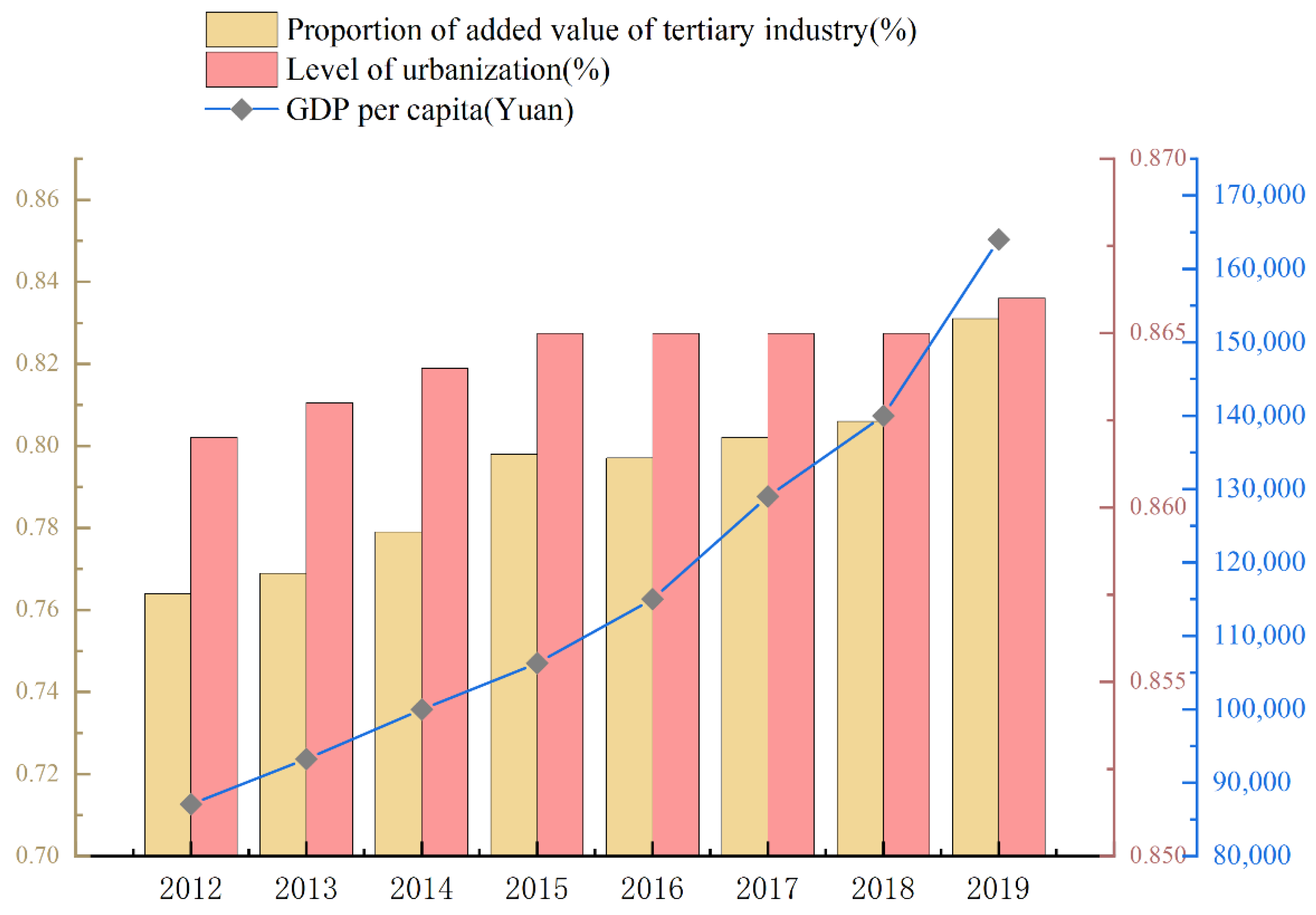
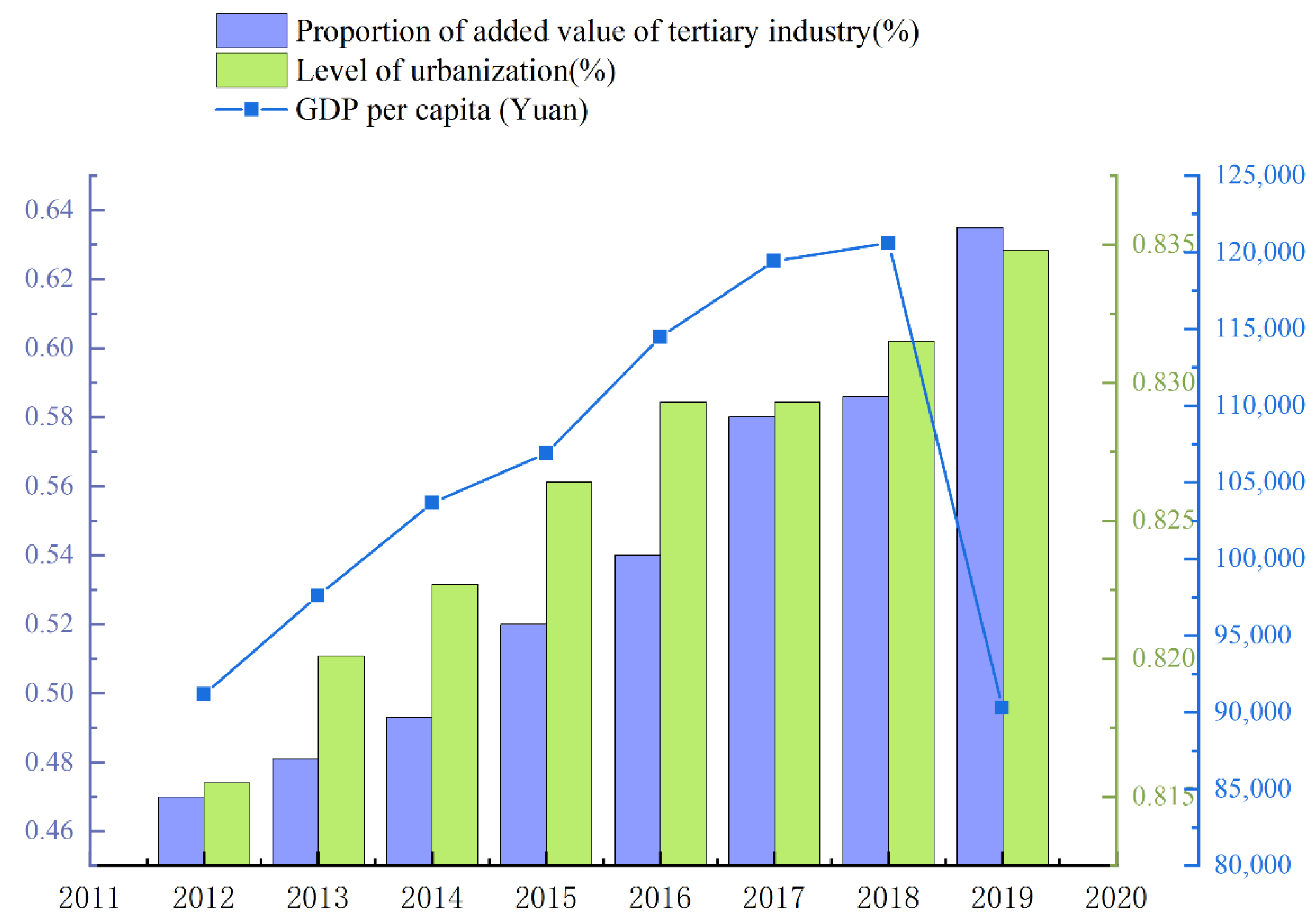
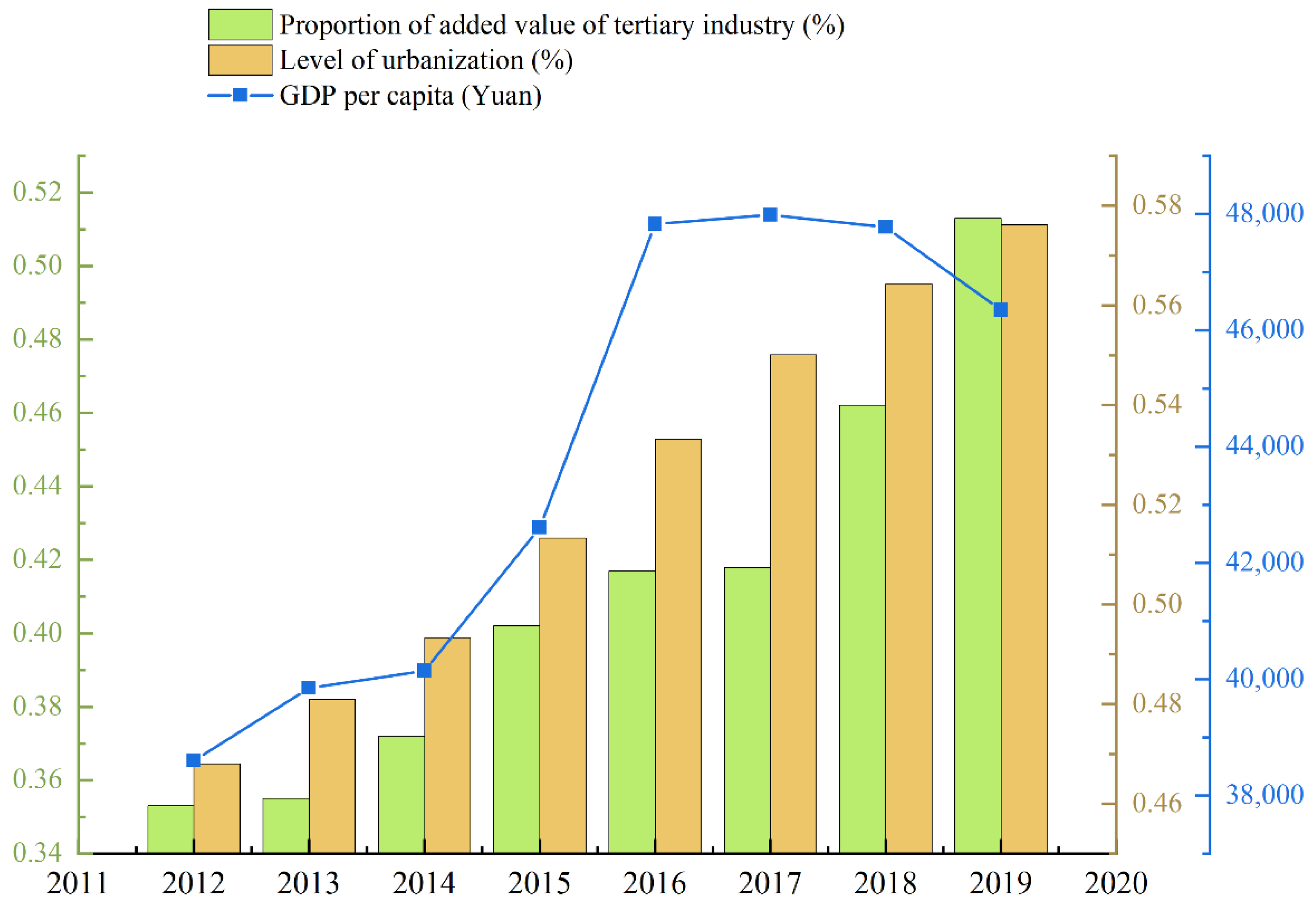
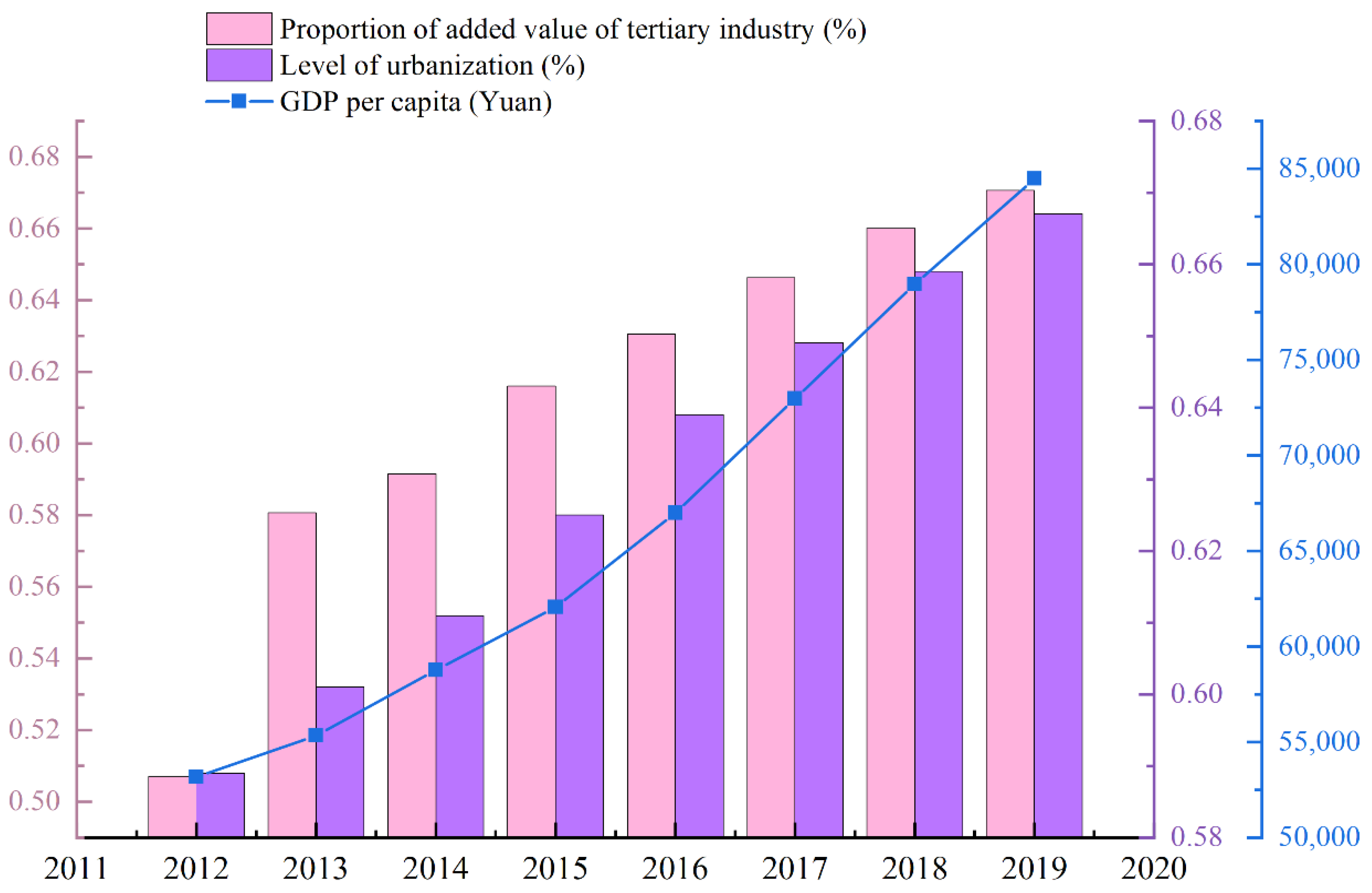
According to the development status of developed countries whose carbon emissions have reached the peak, it can be preliminarily determined that the carbon peak can be achieved when the per capita GDP reaches more than $20,000, the urbanization rate reaches more than 75%, and the added value of the tertiary industry reaches more than 65%.Based on the data of the three indicators from 2012 to 2019 in Figure 2, Figure 3, Figure 4 and Figure 5, the FGM (1,1) model is used to predict the future values of the above three indicators. Thus analysis of the Beijing–Tianjin–Hebei region carbon peak period.
According to the indicator data in Figure 2 and the achievement of carbon peak standards in developed countries, Beijing’s carbon emissions have already reached the peak, so there is no need to predict the carbon emissions deadline. It is only necessary to predict the indicators that have not reached the national carbon peak standards in Tianjin, Hebei and Beijing–Tianjin–Hebei regions. Due to the different calculation standards of Tianjin’s per capita GDP in 2019, the calculation results have declined, resulting in the use of the FGM (1,1) model calculation results to increase first and then decrease, which reflects the FGM (1,1); it works better in exponentially smoothed sequences. Therefore, the forecast of Tianjin’s per capita GDP uses the median forecast of the growth rate from 2012 to 2019. The urbanization level and the proportion of tertiary industry in Hebei province are calculated according to the average growth rate from 2012 to 2019. This method combines the FGM (1,1) model, and the statistical calculation makes the prediction result of carbon peak time in Beijing–Tianjin–Hebei region more accurate. The results of the carbon peak period are shown in Table 2.
According to the prediction results in Table 2, Beijing achieved the carbon peak target. According to the per capita GDP index, Tianjin will achieve the carbon peak goal in 2028. Judging by the proportion of the tertiary industry, the peak will be reached in 2020. The process of carbon peak realization in Hebei is slow. According to the three indicators of per capita GDP, urbanization level and the proportion of the tertiary industry, the time of carbon peak realization is 2053, 2027 and 2027, respectively. The entire Beijing–Tianjin–Hebei region will reach a carbon peak in 2044 at the latest. Based on the above results, Hebei should increase the intensity of carbon emission reduction, accelerate the pace of economic development, and take the road to green development.

4. Spatial Differentiation Analysis of Carbon Peak in Beijing–Tianjin–Hebei Region

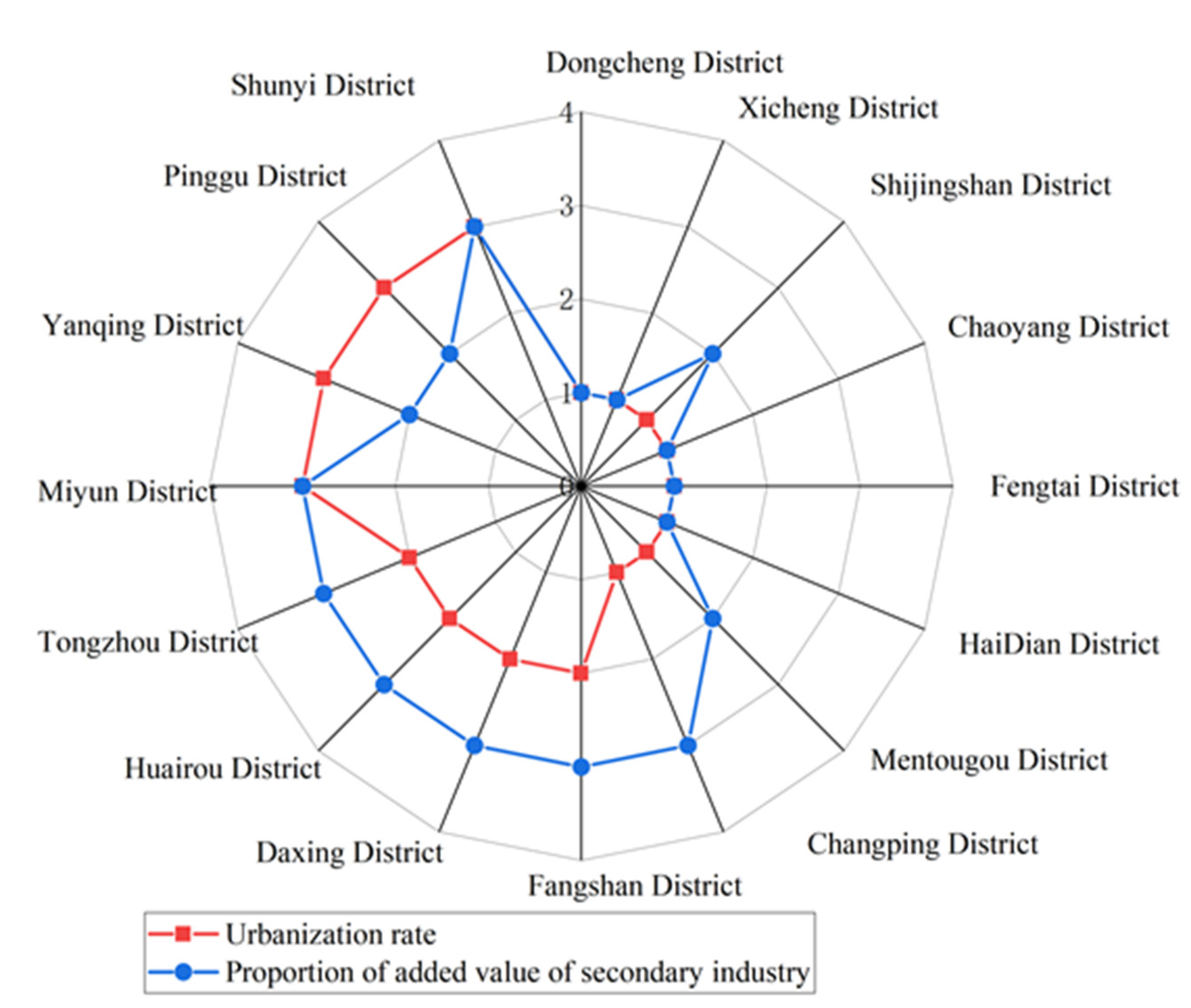
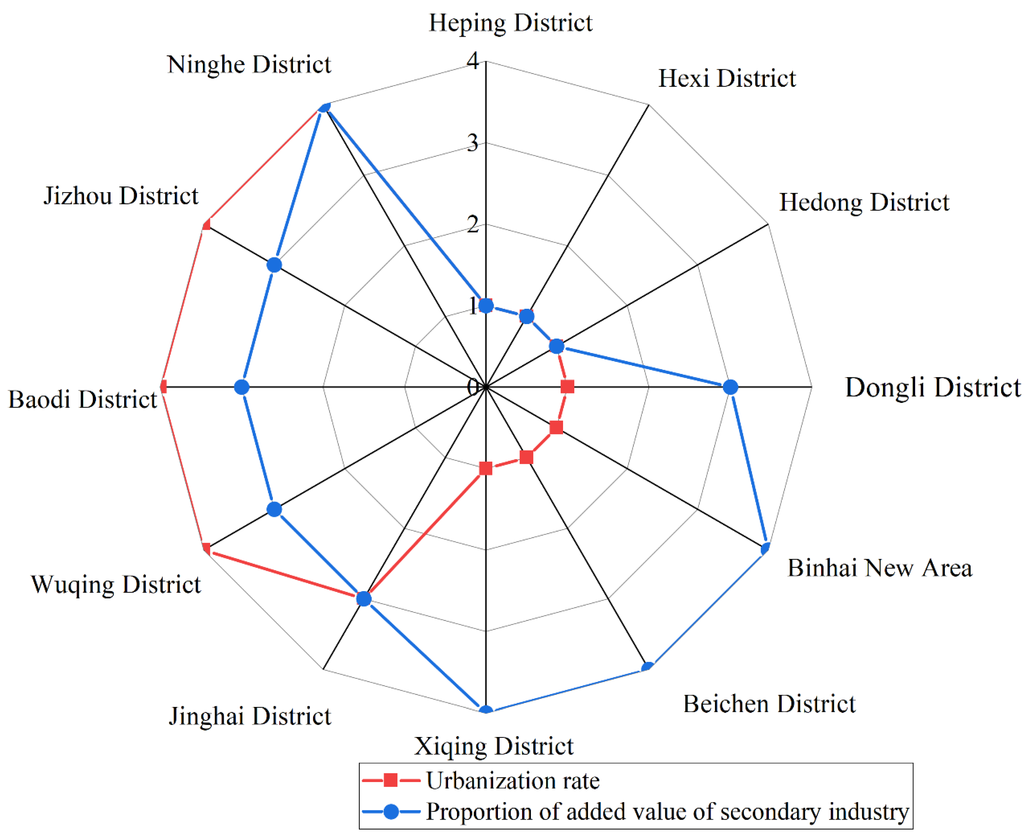
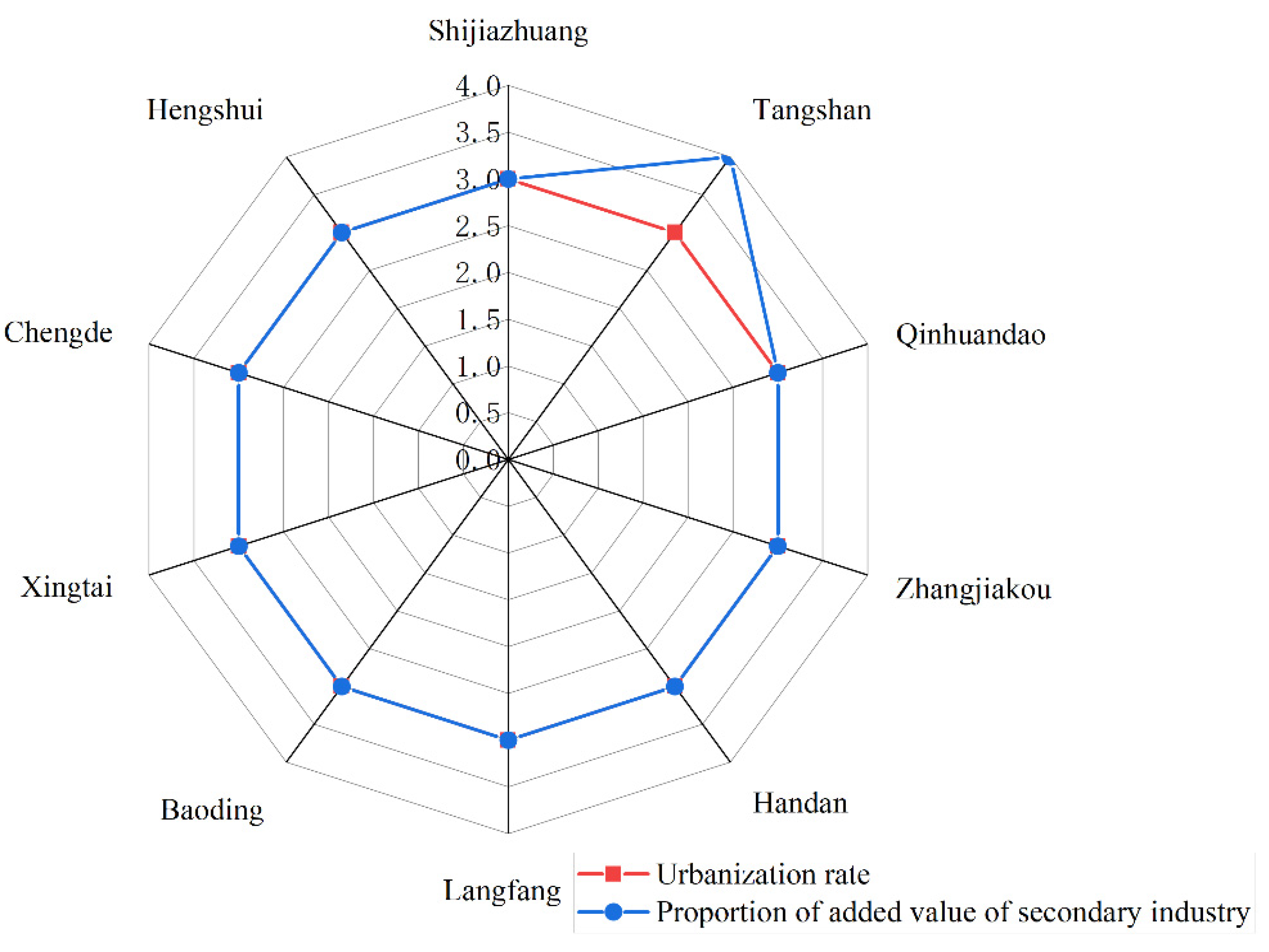
Beijing–Tianjin–Hebei is the abbreviation of Beijing–Tianjin–Hebei Province, where Beijing is the capital of China and Tianjin is one of the municipalities directly under the Central Government. Therefore, there is a big difference in the level of development between the Beijing–Tianjin–Hebei region. Through research, it was found that there are big differences in the level of urbanization and the proportion of the added value of the secondary industry between the Beijing–Tianjin–Hebei region. Based on the data of each district and city in 2018, this paper divides the urbanization level and the proportion of the added value of the secondary industry into four levels. Among them, the urban level was arranged in order of low to high, and the proportion of the added value of the secondary industry was arranged from high to low. A two-line radar chart was drawn. The results are shown in Figure 6, Figure 7 and Figure 8.
In the Figure 6, Figure 7 and Figure 8, the further away from the center of the circle the urbanization level is, the higher the urbanization level is. Generally speaking, the higher the urbanization level of a region is, the lower the proportion of the added value of the secondary industry is, and the easier it is for the carbon emissions of the region to reach the peak. Therefore, the degree of difficulty of carbon peak is divided into the first peak, peak on schedule (easy)and peak on schedule (general), which may be overdue peak four grades. It corresponds to a high level of urbanization and a low proportion of the added value of the secondary industry. The urbanization rate is high, and the proportion of the added value of the secondary industry is low. The level of urbanization is medium, and the proportion of the added value of the secondary industry is medium. Low level of urbanization, secondary industry accounted for a high proportion of added value.
According to Figure 6, the urbanization rate of each district in Beijing is in the top three levels, with the urbanization rate above 50%. The proportion of the added value of the secondary industry is lower than that of the central region. Most areas are expected to reach peak time. Among them, Dongcheng District, Xicheng District, Chaoyang District, Fengtai District, Shijingshan District, Haidian District can achieve the first peak, Changping area on schedule to peak (easy), the rest of the peak on schedule (general).
As shown in Figure 7, Tianjin’s six districts (Heping District, Hexi District, Hedong District, Hebei District, Nankai District, Hongqiao District) can take the lead in reaching the peak, Dongli District, Xiqing District, Beichen District, Binhai New District The level of urbanization is high, and the proportion of regional industry added value is also high. It can reach the peak on time (easy). The urbanization rate of Ninghe District and Jizhou District is low, and the proportion of secondary industry added value may reach the peak overdue. The urbanization rate of Wuqing District, Baodi District, and Jinghai District are equivalent to the proportion of the added value of the secondary industry, so it may reach the peak (general) on schedule.
According to Figure 8, the urbanization rate in all parts of Hebei is at the third level, with the urbanization rate ranging from 50% to 60%, while the secondary industry’s added value accounts for a medium to a high level. Among them, the proportion of the added value of the secondary industry in Tangshan is the highest. According to the division basis and the development status of Hebei Province over the years, Shijiazhuang may reach its peak as scheduled by 2030, and the goal of achieving carbon peaks in most other regions requires joint efforts from multiple parties.
In summary, there is a big difference in the degree of difficulty for Beijing, Tianjin and Hebei to achieve a carbon peak. Beijing and Tianjin are relatively easy to achieve carbon peak, while most parts of Hebei are more difficult to achieve carbon peak by 2030. Therefore, according to the functional positioning of Beijing, Tianjin and Hebei in the future, we should coordinate low-carbon development to achieve a carbon peak in the Beijing, Tianjin and Hebei region as soon as possible to help China achieve a carbon peak by 2030.

5. Conclusions and Countermeasures to Speed up the Realization of the Dual Carbon Goal in the Beijing–Tianjin–Hebei Region

Based on the above time-space analysis of carbon emissions in the Beijing–Tianjin–Hebei region, benchmarking European and American countries’ carbon-neutral time limit (2050) [32]. It is predicted that the Beijing–Tianjin–Hebei region will achieve a carbon peak in 2044. At this rate, the probability of achieving carbon neutrality in the Beijing–Tianjin–Hebei region by 2060 is slim. Therefore, it is necessary to accelerate the pace of regional carbon peaking and carbon neutrality to accelerate the achievement of the carbon peaking and carbon-neutral goals in the Beijing–Tianjin–Hebei region. In terms of space, carbon emissions in the Beijing–Tianjin–Hebei region are closely related to the level of regional urbanization and the proportion of the added value of the secondary industry. The carbon peak area is closely related to the level of urbanization, economic development and population in the area. With the rapid development of the social economy, the state has implemented a series of measures for the Beijing–Tianjin–Hebei region. For example, the coordinated development of Beijing–Tianjin–Hebei. The fractional accumulation GM (1,1) used in this paper to predict the carbon peak period in the Beijing–Tianjin–Hebei region is consistent with the results of Zang et al.’s research on the carbon dioxide emission peak in the Beijing–Tianjin–Hebei urban agglomeration [33]. That is, Beijing and Tianjin have achieved carbon peaks. In addition, the model can also be used for many aspects of forecasting, air quality forecasting and water quality forecasting, and it has a wide range of applications.
Since General Secretary Xi Jinping proposed the coordinated development of Beijing–Tianjin–Hebei in February 2014, Hebei Province has firmly grasped the key to resolving non-capital functions, effectively serving and undertaking the industrial transfer of Beijing-Tianjin, and accelerating the realization of high-quality development of Beijing–Tianjin–Hebei. The focus of work for non-capital functions should be clarified; the population should be evacuated; and shut down and transfer enterprises with high energy consumption, heavy pollution and high emissions. The proposal of this measure makes it easier for the Beijing–Tianjin area to achieve the “dual carbon” goal. However, Hebei Province needs many efforts to achieve the “dual carbon” goal. In fact, studies have shown that Beijing’s total carbon dioxide emissions will reach a historical peak in 2020, and the future carbon emissions will still be relatively large after reaching the peak [34]. This is closely related to the economic development, energy structure and population of Beijing’s various regions. As the capital of China, Beijing attracts more and more migrants, consumes a lot of carbon emissions, and has relatively high per capita carbon emissions. Therefore, to achieve effective control of the total carbon emissions in the Beijing area, huge efforts must be made [35]. In order to achieve the goal of carbon peaking and carbon neutrality on schedule, the 29th meeting of the Standing Committee of the Seventeenth People’s Congress of Tianjin passed the “Regulations for the Promotion of Carbon Neutrality of Carbon Peaking in Tianjin” on 27 September 2021. The Hebei Provincial Government issued the “Implementation Opinions on Establishing and Improving an All-Green and Low-Carbon Circular Development Economic System.” All parts of Beijing–Tianjin–Hebei are making efforts to achieve this end. In order for the Beijing–Tianjin–Hebei region to achieve the “dual carbon” goal as scheduled and effectively control the total carbon emissions, the following suggestions are put forward according to the difficulty level of achieving the carbon peak, as shown in Table 3, Table 4, Table 5 and Table 6.
While promoting the strategic adjustment of industrial structure and the industrial transformation and transfer between Beijing and Tianjin, the Beijing–Tianjin–Hebei region should also improve its carbon sink capacity. Carbon neutrality is mainly reflected in carbon sink capacity. When carbon dioxide emissions are controlled and reduced to a certain extent, the carbon sink capacity of the Beijing–Tianjin–Hebei region will be greatly improved. The carbon neutralization capacity of the region should be analyzed according to the regional population density and industrial type so as to make the intensive industrial areas and along the traffic trunk lines become carbon sink areas and form a network of carbon sink areas according to the traffic trunk lines in all directions of Beijing Tianjin Hebei region. In addition, the construction of urban greening and green screen at the edge of the city is also very important.

Author Contributions

Z.L.: Data curation, investigation, methodology, project administration and editing. M.W.: Resources, formal analysis, validation, visualization and participation in data query. L.W.: Conceptualization, funding acquisition and supervision. All authors have read and agreed to the published version of the manuscript.

Funding

This research was funded by the key research project in humanity and social science of Hebei Education Department (ZD202211), the Natural Science Foundation of Hebei Province (E2020402074), the young talent support scheme of Hebei Province (360-0803-YBN-7U2C) and Anhui philosophy and Social Sciences incubation project (AHSKF2020D01).

Data Availability Statement

The research data in this article come from Beijing Statistical Yearbook, Tianjin Statistical Yearbook and Hebei Economic Yearbook over the years.

Acknowledgments

The relevant researches are supported by the spatio-temporal evolution of county economy in Hebei Province under the background of coordinated development of Beijing-Tianjin-Hebei (SQ182026).

Conflicts of Interest

The authors declare that they have no conflict of interest.

References

  1. Fang, D.; Zhang, X.; Yu, Q.; Jin, T.C.; Tian, L. A novel method for carbon dioxide emission forecasting based on improved Gaussian processes regression. J. Clean. Prod. 2018, 173, 143–150. [Google Scholar] [CrossRef]
  2. Yan, W.; Huang, Y.; Dong, H. Carbon emission prediction of Shandong peninsula blue economic zone based on STIRPAT model. J. Univ. Jinan (Sci. Technol.) 2021, 35, 125–131. [Google Scholar]
  3. Zhang, Z.; Ren, Y.; Dong, H. Urban carbon emission peaking and low-carbon development: A case study of Shanghai. Environ. Eng. 2020, 38, 12–18. [Google Scholar]
  4. Liu, X.; Meng, X.; Wang, X. Carbon Emissions Prediction of Jiangsu Province Based on Lasso-BP Neural Network Combined Model. In The IOP Conference Series: Earth and Environmental Science, Proceedings of Carbon Emissions Prediction of Jiangsu Province Based on Lasso-BP Neural Network Combined Model; IOP: Bristol, UK, 2021; Volume 769, No. 2; p. 022017. [Google Scholar]
  5. Wang, K.; Niu, D.; Zhen, H.; Sun, L.; Xu, X. Carbon emission forecasting in China based on WOA-ELM Model. Ecol. Econ. 2020, 36, 20–27. [Google Scholar]
  6. Zhu, C.; Wang, M.; Du, W.; Dolezel, P. Prediction on Peak Values of Carbon Dioxide Emissions from the Chinese Transpor-tation Industry Based on the SVR Model and Scenario Analysis. J. Adv. Transp. 2020, 2020, 8848149. [Google Scholar] [CrossRef]
  7. Ding, S.; Xu, N.; Ye, J.; Zhou, W.; Zhang, X. Estimating Chinese energy-related CO2 emissions by employing a novel discrete grey prediction model. J. Clean. Prod. 2020, 259, 120793. [Google Scholar] [CrossRef]
  8. Liang, Y.; Lei, S. Analysis and trend forecast of carbon emission factors in the six provinces of central China—An empirical study based on STIRPAT and Grey GM(1,1) Model. Value Eng. 2019, 38, 11–14. [Google Scholar]
  9. Gao, M.; Yang, H.; Xiao, Q.; Goh, M. A novel method for carbon emission forecasting based on Gompertz’s law and fractional grey model: Evidence from American industrial sector. Renew. Energy 2022, 181, 803–819. [Google Scholar] [CrossRef]
  10. Gao, M.; Yang, H.; Xiao, Q.; Goh, M. A novel fractional grey Riccati model for carbon emission prediction. J. clean. prod. 2021, 282, 124471. [Google Scholar] [CrossRef]
  11. Xu, Z.; Liu, L.; Wu, L. Forecasting the carbon dioxide emissions in 53 countries and regions using a non-equigap grey model. Environ. Sci. Pollut. Res. Int. 2021, 28, 15659–15672. [Google Scholar] [CrossRef]
  12. Xiang, X.; Cai, Y.; Xie, S. Application of a new information priority accumulated grey model with simpson to forecast carbon dioxide emission. J. Adv. Math. Comput. Sci. 2020, 70–83. [Google Scholar] [CrossRef] [Green Version]
  13. Duan, H.; Wang, D.; Pang, X.; Liu, Y.; Zeng, S. A novel forecasting approach based on multi-kernel nonlinear multivariable grey model: A case report. J. Clean. Prod. 2020, 260, 120929. [Google Scholar] [CrossRef]
  14. Xu, G.; Schwarz, P.; Yang, H. Adjusting energy consumption structure to achieve China’s CO2 emissions peak. Renew. Sustain. Energy Rev. 2020, 122, 109737. [Google Scholar] [CrossRef]
  15. Boamah, K.B.; Du, J.; Adu, D.; Mensah, C.N.; Dauda, L.; Khan, M.A.S. Predicting the carbon dioxide emission of China using a novel augmented hypo-variance brain storm optimization and the impulse response function. Environ. Technol. 2021, 42, 4342–4354. [Google Scholar] [CrossRef] [PubMed]
  16. Cui, G.; Yu, Y.; Zhou, L.; Zhang, H. Driving forces for carbon emissions changes in Beijing and the role of green power. Sci. Total Environ. 2020, 728, 138688. [Google Scholar] [CrossRef] [PubMed]
  17. Ye, L.; Xie, N.; Hu, A. A novel time-delay multivariate grey model for impact analysis of CO2 emissions from China’s transportation sectors. Appl. Math. Model. 2021, 91, 493–507. [Google Scholar] [CrossRef]
  18. Yang, X.; Meng, C.; Lin, J. Research on the Spatio-temporal evolution and regional heterogeneity of carbon emissions in Beijing’s four functional zones. J. China Univ. Geosci. (Soc. Sci. Ed.) 2021, 21, 77–90. [Google Scholar]
  19. Xu, G.; Cai, Z.; Feng, S. Research on the temporal and spatial differences of carbon emissions and influencing factors based on the two-stage LMDI Model—Taking Jiangsu Province as an example. Soft Sci. 2021, 35, 107–113. [Google Scholar] [CrossRef]
  20. Yang, X.; Jia, Z.; Yang, Z.; Yuan, X. The effects of technological factors on carbon emissions from various sectors in China—A spatial perspective. J. Clean. Prod. 2021, 301, 126949. [Google Scholar] [CrossRef]
  21. Zhao, Z.Y.; Yuan, S.G.; Fu, Y.; Wang, Y.; Li, H. Analysis of the Spatial and Temporal Differences of China’s Power Carbon Footprint. J. Electr. Comput. Eng. 2020, 2020, 3701939. [Google Scholar] [CrossRef] [Green Version]
  22. Xu, Q.; Dong, Y.X.; Yang, R.; Zhang, H.O.; Wang, C.J.; Du, Z.W. Temporal and spatial differences in carbon emissions in the Pearl River Delta based on multi-resolution emission inventory modeling. J. Clean. Prod. 2019, 214, 615–622. [Google Scholar] [CrossRef]
  23. Wang, R.; Feng, Y. Research on China’s agricultural carbon emission efficiency evaluation and regional differentiation based on DEA and Theil models. Int. J. Environ. Sci. Technol. 2021, 18, 1453–1464. [Google Scholar] [CrossRef]
  24. Liu, H.; Song, Y. Financial development and carbon emissions in China since the recent world financial crisis: Evidence from a spatial-temporal analysis and a spatial Durbin model. Sci. Total Environ. 2020, 715, 136771. [Google Scholar] [CrossRef] [PubMed]
  25. Bai, C.; Zhou, L.; Xia, M.; Feng, C. Analysis of the spatial association network structure of China’s transportation carbon emissions and its driving factors. J. Environ. Manag. 2020, 253, 109765. [Google Scholar] [CrossRef]
  26. Ding, B.; Zhao, Y.; Deng, J. Research on Measurement, Decoupling Characteristics and Driving Factors of Carbon Emissions from China’s Planting Industry. J. China Agric. Resour. Reg. Plan. 2021, 1–14. [Google Scholar]
  27. Cao, J.; Zhou, L. Research on the Spatial and Temporal Distribution of Carbon Emissions of Logistics Industry in the Yang-tze River Delta and Its Influencing Factors. Stat. Decis. 2021, 37, 79–83. [Google Scholar]
  28. Wang, X.X.; He, A.Z.; Zhao, J. Regional disparity and dynamic evolution of carbon emission reduction maturity in China’s service industry. J. Clean. Prod. 2020, 244, 118926. [Google Scholar] [CrossRef]
  29. Tang, C.; Wan, Z.; Ng, P.; Dai, X.; Sheng, Q.; Chen, D. Temporal and Spatial Evolution of Carbon Emissions and Their Influencing Factors for Tourist Attractions at Heritage Tourist Destinations. Sustainability 2019, 11, 5944. [Google Scholar] [CrossRef] [Green Version]
  30. Liu, S.; Xiao, Q. An empirical analysis on spatial correlation investigation of industrial carbon emissions using SNA-ICE model. Energy 2021, 224, 120183. [Google Scholar] [CrossRef]
  31. Wu, L.; Liu, S.; Yao, L.; Yan, S.; Liu, D. Grey system model with the fractional order accumulation. Commun. Nonlinear Sci. Numer. Simul. 2013, 18, 1775–1785. [Google Scholar] [CrossRef]
  32. Zhang, Y.; Luo, H.; Wang, C. International Trend Analysis of Carbon Neutrality Action. Adv. Clim. Chang. Res. 2021, 17, 88–97. [Google Scholar]
  33. Zang, H.; Yang, W.; Zhang, J. Research on peak carbon dioxide emissions in Beijing-Tianjin-Hebei urban agglomeration. Environ. Eng. 2020, 38, 19–24. [Google Scholar]
  34. Li, J.; Gu, A.; Zhang, C. “Fourteenth Five-Year Plan” China’s provincial economic development, energy demand and carbon emissions prospects-based on the analysis of the CMRCGE model. Adv. Clim. Chang. Res. 2019, 15, 649–659. [Google Scholar]
  35. Qi, W.; Li, G. Residential carbon emission embedded in China’s inter-provincial population migration. Energy Policy 2020, 136, 111065. [Google Scholar] [CrossRef]
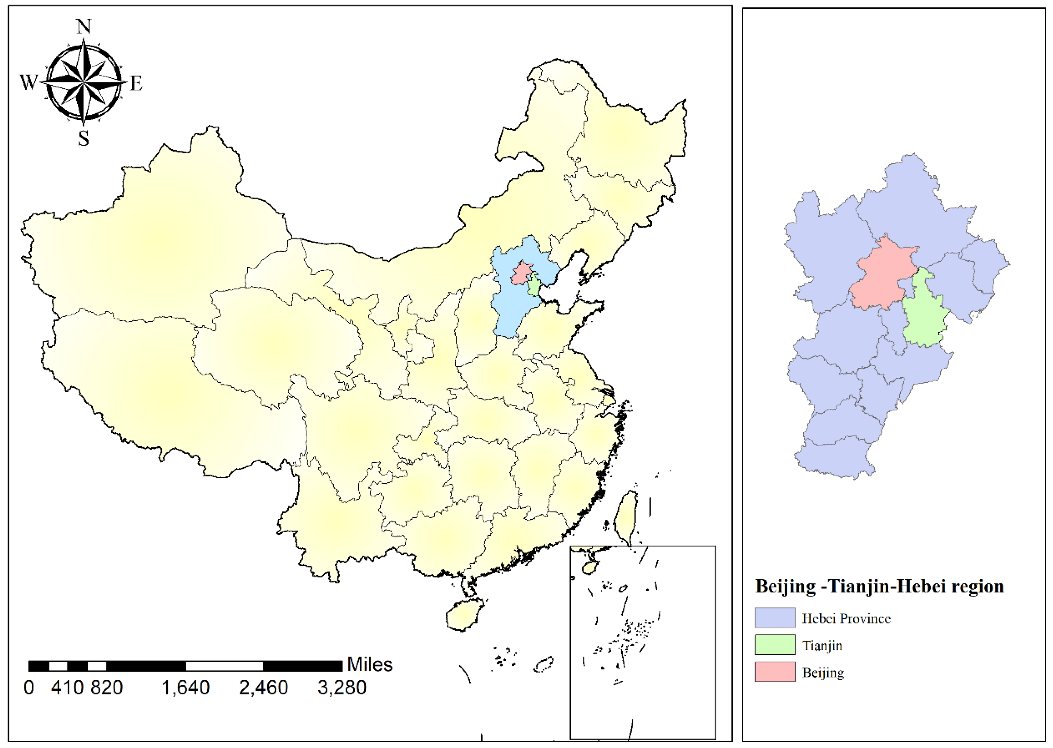
Figure 1. Geographical location of Beijing–Tianjin–Hebei region.
Axioms 11 00215 g001
Figure 2. Index data affecting carbon emission in Beijing.
Axioms 11 00215 g002
Figure 3. The development trend of indicators affecting the carbon peak period in Tianjin.
Axioms 11 00215 g003
Figure 4. Indicators affecting the carbon peak period in Hebei Province.
Axioms 11 00215 g004
Figure 5. Indicators of carbon emission period forecast in the Beijing–Tianjin–Hebei region from 2012 to 2019.
Axioms 11 00215 g005
Figure 6. Spatial analysis chart of the proportion of added value between urbanization and secondary industry in Beijing.
Axioms 11 00215 g006
Figure 7. Spatial analysis chart of the proportion of added value between urbanization and secondary industry in Tianjin (Note: Due to missing data of Hexi District, Nankai District, Hongqiao District and Jinnan District, these areas are not included in Figure 7).
Axioms 11 00215 g007
Figure 8. Spatial analysis chart of the proportion of urbanization rate and added value of the secondary industry in Hebei Province.
Axioms 11 00215 g008
Table 1. Fitting results of per capita GDP in Hebei Province.
YearReal ValueFGM (1,1)GM (1,1)
201238,596.6338,596.6338,596.63
201339,845.8839,300.4040,572.05
201440,143.3341,847.9541,860.43
201542,607.3543,923.4743,189.74
201647,827.5245,402.4644,561.25
201747,985.0046,370.2945,976.32
201847,772.0046,931.1247,436.32
201946,348.0047,176.4448,942.69
MAPE 2.59%3.1%
Table 2. The prediction results of the carbon peak period.
AreaGDP Per Capita/(Yuan/person)Level of Urbanization/%Proportion of Added Value of Tertiary Industry/%
Beijing2019164,00086.60%83.10%
Estimated realization time(129,000) 2018ImplementedImplemented
Tianjin201990,306.1283.48%63.50%
Estimated realization time(129,000) 2028Implemented(65%)2020
Hebei201946,34857.6251.03%
Estimated realization time(129,000) 2053(75%)2027(65%)2027
Beijing–Tianjin–Hebei Region201984,479.2366.767.06%
Estimated realization time(129,000) 2025(75%) 2044(65%)2018
Note: Calculated according to the exchange rate of 6.4593, the per capita GDP, urbanization rate and tertiary industry’s added value are 20,000 USD/person (equivalent to more than 129,000 RMB), 75% and 65%, respectively.
Table 3. Suggestions for areas that are the first to achieve carbon peak.
RegionImplementation of the Main BodyCorresponding SuggestionsCorresponding Region
First reach peak areaUrban government, Ecological environment administration, Energy department, Transportation management department, Development and Reform Commission
1.
Control the rate of population growth
2.
Adjust the energy consumption structure, increase the input of clean energy, reduce the consumption of fossil energy, strive to achieve the supply of clean energy, control the total amount of CO2 emissions
3.
Vigorously promote new energy vehicles
4.
Successful treatment of black and odorous water bodies has been achieved
5.
Protect the safety of drinking water, supervise water sources and protected natural areas
6.
Industries that consume energy and pollute heavily will be relocated
Dongcheng District,
Xicheng District, Shijingshan District,
Chaoyang District,
Fengtai District, Haidian District, Mentougou District,
Heping District,
Hexi District, Hedong District, Nankai District, Hongqiao District
Table 4. Recommendations for areas that are easy to peak carbon on time.
RegionImplementation of the Main BodyCorresponding SuggestionsCorresponding Region
Easy to peak on scheduleUrban government, Ecological environment administration, Development and Reform Commission
1.
The success rate of industrial transfer and transformation has reached 60%
2.
Expand the use of clean energy to 75%
3.
By 2020, regional black and odorous water bodies will be under control
4.
Pilot projects to monitor drinking water sources and protected natural areas
5.
Energy conservation and emission reduction, promote green development
6.
Control the development speed of construction industry, reduce the carbon emission of construction
Changping District, Fangshan District, Daxing District, Huairou District, Tongzhou District, Yanqing, Pinggu, Miyun District, Shunyi District, Binhai New District, Beichen District, Dongli District, Xiqing District, Shijiazhuang
Table 5. Recommendations for areas that are generally easy to achieve peak carbon on time.
RegionImplementation of the Main BodyCorresponding SuggestionsCorresponding Region
Generally easy to peak on scheduleEcological environment administration agency, District (city) government, Development and Reform Commission
1.
Further optimize the industrial structure and eliminate “disorderly and dirty” enterprises.
2.
Adjust the energy mix and increase the share of non-fossil energy in primary energy consumption.
3.
Strengthen coordinated control of greenhouse gases and conventional air pollutants, and realize air pollution days in autumn and winter.
4.
Vigorously promote clean energy heating and accelerate the project to replace bulk coal.
5.
Prevent rebounding after successful treatment of black and smelly water bodies.
Wuqing District, Baodi District, Jinghai District, Tangshan, Qinhuangdao, Handan, Xingtai, Baoding, Zhangjiakou, Chengde, Langfang, Hengshui
Table 6. Recommendations for areas that may be overdue for carbon peak.
RegionImplementation of the Main BodyCorresponding SuggestionsCorresponding Region
May reach peak overdueMunicipal ecological environment administration agency, Development and Reform Commission
1.
Focus on the areas that may be overdue to achieve the carbon peak target, and make reasonable adjustments to the energy structure and industrial structure of these areas
2.
To realize the construction of low-carbon industrial parks
3.
Strictly prevent the revival of “scattered and dirty” enterprises
4.
Relevant departments at all levels detailed and decomposed targets strictly implemented relevant tasks and requirements, and held accountable those who failed to meet the targets.
Jizhou District, Ninghe District
Publisher’s Note: MDPI stays neutral with regard to jurisdictional claims in published maps and institutional affiliations.