1. Introduction
The objective of this paper is to provide an overview of the naturally radioactive geologic units in known areas of Stara Planina (also known as the Balkan mountain range). The studied localities include Mezdreja and Gabrovnica (abandoned mines in the Janja granites), graphitic schists of the Paleozoic “Inovo Series”, and early Triassic sedimentary units in the Dojkinci–Jelovica area. These occurrences are known and have been described in papers, reports and books, largely from the perspective of mineral exploration, origin or ecology. This paper aims to characterize naturally radioactive units, with regard to their location, macroscopic and microscopic features, chemical composition, and radioactivity of a specific sample determined both in situ and in the laboratory. In other words, the objective is to provide answers to the questions: which are the particular geologic units? What are their petrologic, mineralogic, geochemical and radiometric characteristics? How did they come about? The paper presents the outcomes of research conducted in the part of Stara Planina in Serbia.
Natural radioactivity is a widely explored subject. On planet Earth, all living beings are exposed to radioactivity. The origin of natural radioactivity is from various rocks enriched with radio elements (uranium 238 and uranium 235, thorium 232 and potassium 40), generated in stars and from cosmic rays [
1]. In China and Brazil natural exposure can be up to 10 to 20 mSv/year. Uranium is widely distributed in nature; it is found in significant concentrations in many rocks and the oceans, as well as in lunar rocks and meteorites. In the Earth’s crust, it is more prevalent than silver, bismuth, cadmium or mercury (it is the 38th most common element). In general, the “Clarke” abundance of uranium is 0.003 ppm in ultramafic, 0.5 ppm in mafic, 1.8 ppm in intermediate, 3.5 ppm in acidic ingneous and up to 60 ppm in alkaline rocks. Also, the uranium content of soils can be up to 1 ppm [
2].
Collection of data on natural radioactivity in the former Yugoslavia began in 1948 at the national Geological Institute (Geoinstitute). Among the voluminous data on the radioactivity of rocks, waters (groundwater and surface water resources), soils, alluvions (recent riverine sediments), and air, most are in their original, or a certain type of interpreted form (such as statistical data), preserved in annual or periodic geological exploration reports, studies, papers, publications, and the like. They are accessible from the archives of Geoinstitute (now the Geological Survey of Serbia), but it is a challenge to unify and convert the data into current units, given that the units have since been changed several times.
Prospecting and exploration of nuclear minerals in Serbia, at different levels of detail, encompassed large areas. The number of data points is on the order of several hundred thousand. So far, the most extensive exploration was conducted in the geographical region of Šumadija (Mt. Bukulja zone) and in Stara Planina, Mt. Cer and Mt. Iverak, where uranium deposits have been identified and reserves estimated.
Uranium exploration on Stara Planina Mt. began in 1949. Extensive slick probe prospecting and walk-over radiometric prospecting were undertaken from 1949 to 1956. Geologic maps were produced on a scale of 1:50,000, and within the zones of the Aldina River and Mezdreja on a scale of 1:10,000. In late 1956 [
3], vein bodies were explored on the Mezdreja locality. Between 1957 and 1966, a geologic-structural map was produced for the Janja granite and exploration conducted on the sediments of the so-called Multicolored Series, of the dispersion aureoles on the Mezdreja locality and later, of the geological-mining operations at Gabrovnica and Mezdreja. Exploration was suspended from the early 1970s to 1978, and from 1978 to the early 1990s it was generally conducted within the area of the Multicolored Series and in the fault zones of the Janja granite.
Since 2000, there has been non-systematic/thematic exploration, generally of radioactivity and its impact on the environment on certain localities on Stara Planina Mt. [
4,
5,
6] (also the methodology in Bai et al. [
7] was considered for future work).
2. Geological Settings
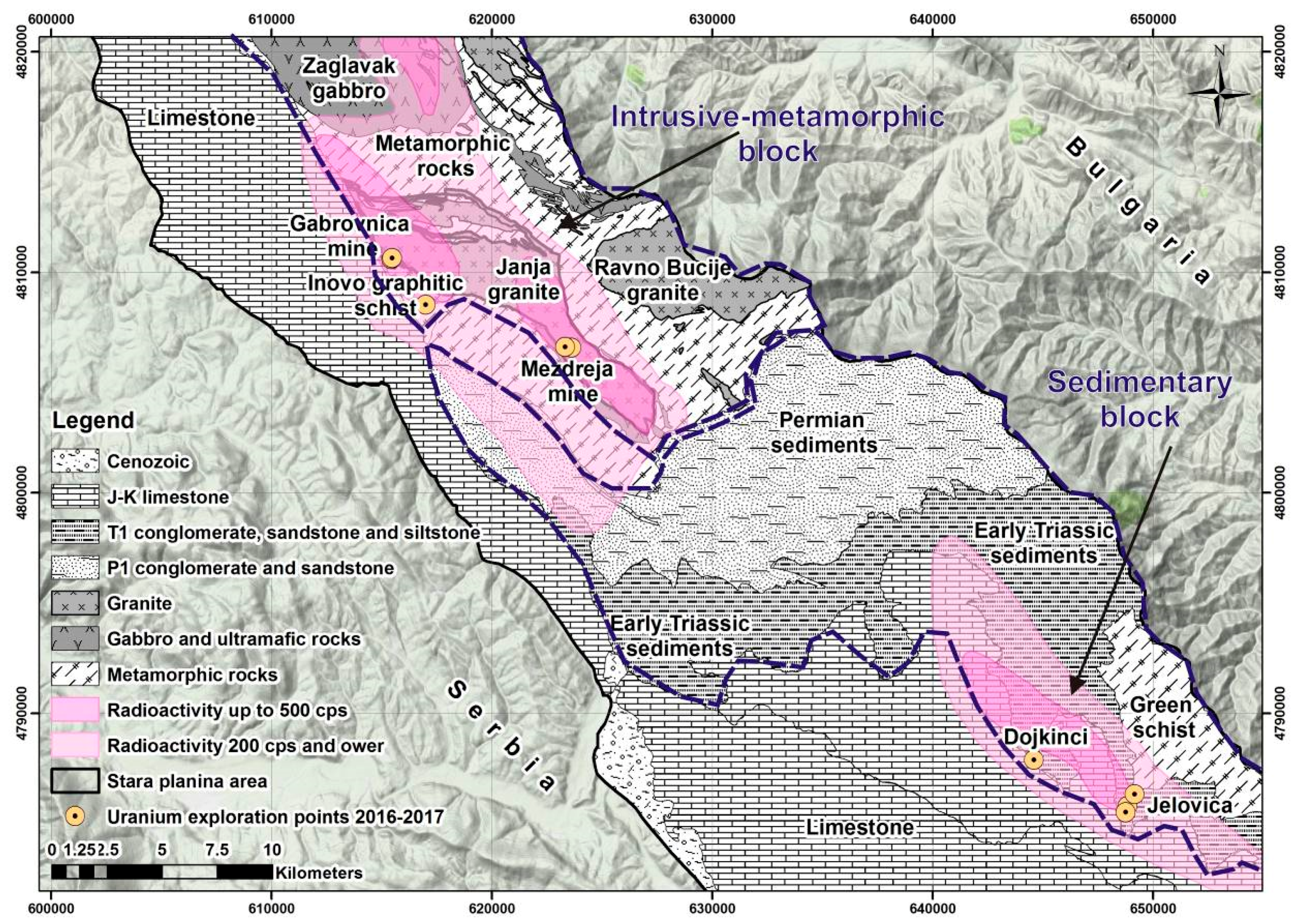
Stara Planina Mt. can be viewed from several perspectives, as a nature park and in terms of geography, geology and geodiversity. The present paper addresses areas of interest from the viewpoint of radioactivity. From the east (ridges) and south, the area is bounded by the border with Bulgaria and from the west (north to south) by several rivers: the Beli Timok, the Trgoviški Timok, the Stanjanska, the Klajča, the Temska and the Nišava. In general terms, only a small part of the mountain range is located in Serbia. The remainder is in Bulgaria and extends all the way to the Black Sea.
On the base geological map of the former Yugoslavia (scale 1:100,000), the area of interest is depicted in the sections on: Bor, Zaječar, Knjaževac and Belogradcig [
8], and in addition Pirot and Breznik [
9]. On the geological map of the Republic of Serbia, at a scale of 1:200,000 [
10], the area of interest is shown in the sections on Knjaževac–Zaječar and Priština–Niš. Both maps were used to produce overview schematic maps of the geologic units discussed in the paper (
Figure 1).
Generally speaking, Stara Planina Mt. is a complex geologic system, built up of different geologic units (with regard to the composition, characteristics and origin). From the north, where the geologic units are separated by structures and where granite and granodiorite intrusions begin, the area is defined by faults that separate the Late Jurassic in the south from the Early Cretaceous in the north. Towards the south, there is a complex geotectonic assemblage made up of the Janja (
Figure 1), Radičevo and Ravno Bučja granites; the Zaglavak gabbro massif; Paleozoic metamorphic rocks (Proterozoic–Cambrian, Silurian–Devonian, the Inovo Series and others); and Permian red sandstones and conglomerates. To the south, there are Mesozoic formations: Triassic (Kopren–Gostuša–Dojkinci), Jurassic (Basara, Odorovci), and Early Cretaceous (Visočka Ržana, Dimitrovgrad). In the southern part of the Mesozoic block the Jurassic and the Cretaceous are intersected by structures running from the northwest to the southeast. The northern boundary of Stara Planina is not clearly defined and can be followed on the Zaječar and Bor maps along Cretaceous formations and intrusions over a length of about 30 km northward and farther via Brusnik and Brestovac to Negotin, but this is not the subject of the present paper.
In 1997, Stara Planina was designated a nature park, where there are a number of unique examples of geodiversity.
The following genetic types of uranium deposits and occurrences can be distinguished on Stara Planina after Gertik [
11] and Kovacevic [
3]: 1. Uranium mineralization in pegmatites; 2. Uranium mineralization related to auto-metasomatic hydrothermal processes in granite; 3. Sedimentary infiltration deposits and occurrences; and 4. Metamorphogenic occurrences.
The map in
Figure 1 includes a schematic representation of the geology and distribution of radioactivity on Stara Planina. In general terms and based on Geoinstitute’s activities [
3], two levels of radioactivity have been identified: (1) about 200 cps, divided into three zones whose total surface area is 307.5 km
2; and (2) greater than 200 and up to 500 cps (mostly greater than 200 cps but rarely 500 cps), divided into four zones whose surface area is 70.84 km
2. The zones were explored by airborne gamma spectrometry during 1981. The methodology of airborne gamma survey consisted of the following: flights was carried out along the straight-line profiles that were at a distance of 250 m from each other. The flight height of a plane was between 100 and 200 m above the surface of the terrain. Detectors used in the airborne gamma survey were crystals of NaJ “GR-800D” activated by a thallium, dimension of crystals was 10 cm × 10 cm × 40 cm [
12].
In essence, the main sources of radioactivity on Stara Planina can be classified as: 1. Granitic endogenous, syngenetic–epigenetic deposits and occurrences; 2. Metamorphogenic, syngenetic; and 3. Sedimentary, including occurrences of uranium deposition and fluctuation caused by water in different types of sedimentary rocks formed in a continental setting, which could be classified under epigenetic types.
2.1. Geological Characteristics of the Janja Granite
The Janja granite massif has intruded into Late Proterozoic and Cambrian crystalline schists. The crystalline schists feature thermo-contact and metasomatic alterations. The primary structural elements include fractures filled with aplite, pegmatite and quartz veins. In places, the fractures trending NW–SE, concentrated on the fringes of the massif, exhibit white mica alteration.
In its north-western part, the massif bifurcates into two masses separated by amphibolites, amphibole schists, gneisses and mica gneisses. Peripherally there are alteration zones developed around the contacts characterized by silification, biotitization and local deposition of feldspar [
8]. The Janja granite is overall calc-alkaline in composition, but with variations such as monzonite–akerite fringes, and an alkaline granite core. Deformations and secondary alterations have been noted in the entire massif, particularly on the fringes. They are represented by a schistose texture, crushed minerals and crystallization of secondary minerals. The primary components are quartz, oligoclase, K-feldspar (microcline, rarely orthoclase), and biotite. The accessory components are sphene, apatite, zircon and magnetite, and the secondary components sericite, chlorite, epidote, calcite, limonite and a clayey substance. There are syenite diorites in the periphery of the Janja granite and on its fringes. Their origin is attributed to contact metasomatic processes in the syenite diorites.
Pegmatite veins are made up of quartz, plagioclase (albite–oligoclase) enriched with U [
13], microcline, biotite and muscovite. The accessory components are apatite, zircon, alanite and metallic minerals. There are quartz veins inside and around the massif. Their thickness is up to several meters and they are up to 200 m long. In addition to quartz, they contain tourmaline and metallic minerals.
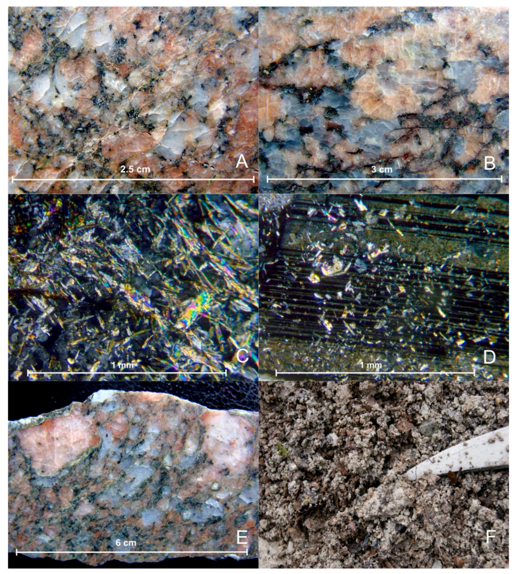
Typical naturally-radioactive geologic representatives were tested within the Janja granite. Samples of granite, the host rock at Mezdreja and Gabrovnica, were of primary interest (
Figure 2A,B). In addition to granite, tailing dump samples from Mezdreja (clayey material with cataclazed granite fragments), silicified batches with limonite stains and fragments of contact gabbroid with coarse (1.5 cm) K-feldspar were examined.
According to Radusinović [
14], in the areas of the uranium mines of Mezdreja and Gabrovnica, the following ore minerals were observed: uraninite and Th-uraninite, pitchblende, thorite, monazite–alanite phases, pyrite, pyrrhotyte, chalcopyrite, valerite, arsenopyrite, galenite, sphalerite, tetraedrite, bismuth, sulpho salts of bismuth and copper, molybdenite, magnetite, hematite and scheelite. Secondary minerals included: malachite, azurite, covellite and limonite, and gangue minerals: quartz, chalcedony, barite, strontianite, kalcite and dolomite.
Detailed information about granite and radioactivity in general is available in Mayers [
15], Rorers et al. [
16] and René and Dolníček [
17].
2.2. Geological Characteristics of Graphitic Schists from the Inovo Series
The Inovo Series transgresses the south-western part of the Janja granite–metamorphic system. Metaconglomerates and metasandstones are the base of the metamorphic-sediment domain. They are overlain by metasandstones containing argillophyllites, with schists in the upper part. The sequence is built up of chlorite–phyllite schists, green schists, amphibolites, graphitic schists, greywackes and conglomerates [
8].
The Inovo Series graphite-bearing schist is located in relative proximity to the Gabrovnica mine, 2.5 km southeast and 1.3 km southwest of the closest mapped point of the Janja granite (
Figure 1).
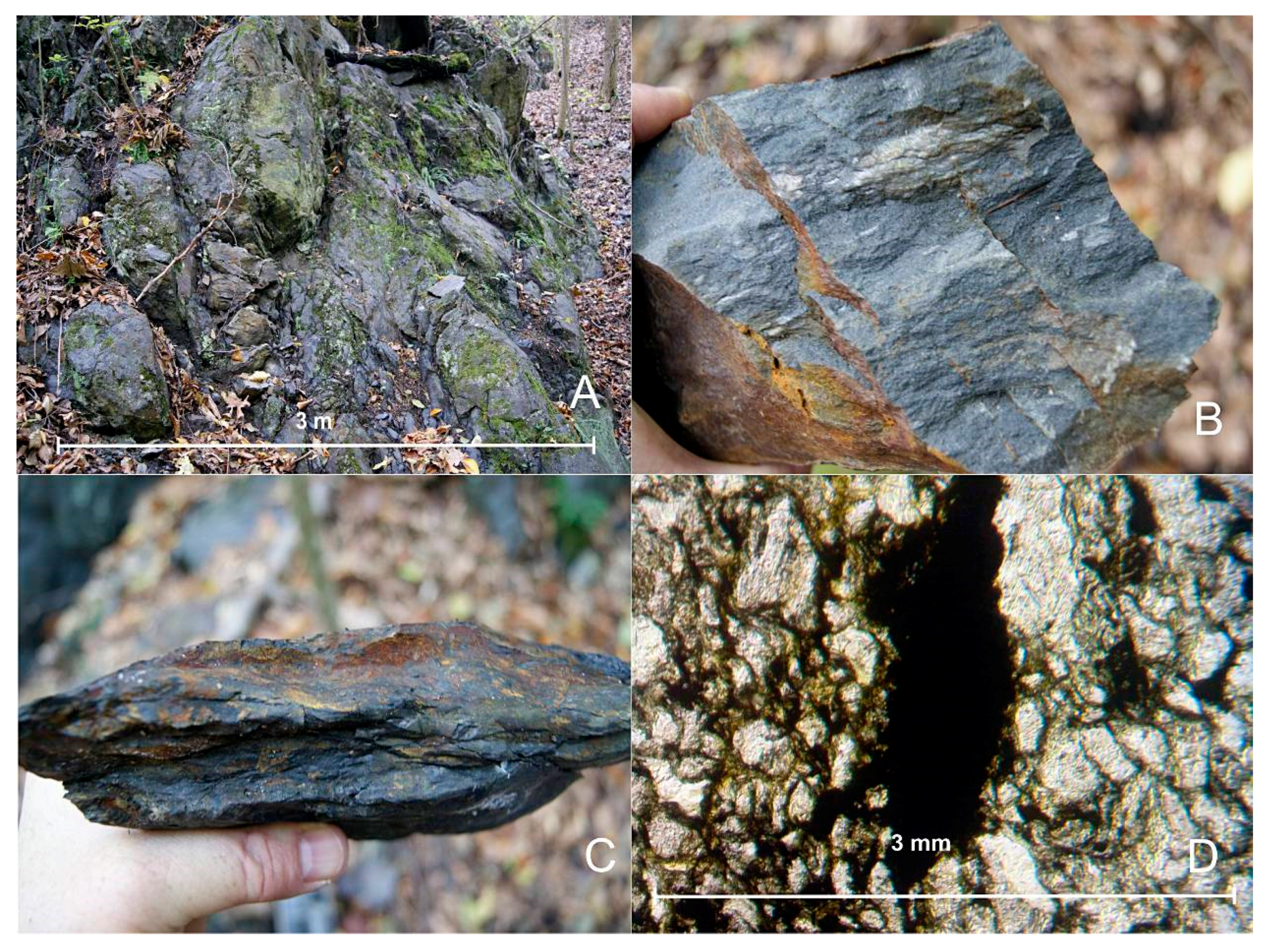
The Inovska River occurrence is situated in the river (on the riverbanks), developed in fractured, altered and brecciated metasandstones with interbeds and lenses of black graphitic schists (
Figure 3A–C), from 50 to 70 m thick.
The upper part of the domain contains layers of coarse-grained and fine-grained metasandstones with black clayey schist intercalations. In the lower part there are brecciated arkose metasandstones. The package dips to the northeast at an angle of 70°–80°.
Uranium mineralization is in the form of elongated lenses in the direction of the dip, following layers of metasediments between coarse-grained metasandstones and black clayey schists [
11]. The lens-like ore body runs along the dip to about 30 m. Ore bodies are built up of carbonitized, pyritized, chloritized and sericitized microconglomerates to arkose sandstones with traces of chalcopyrite and galenite.
2.3. Geological Characteristics of the Multicolored Series
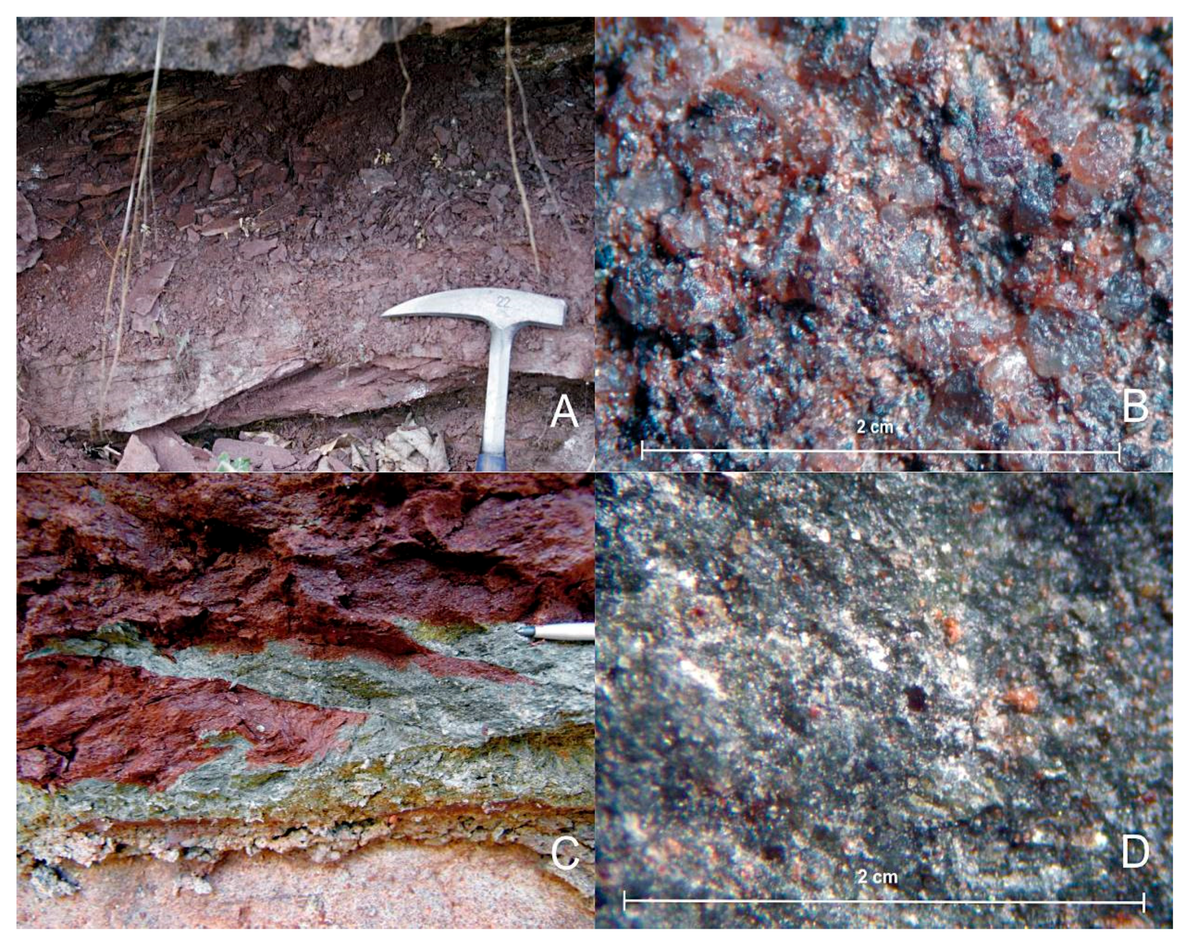
The observation points within the Multicolored Series are located in an area defined as Early Triassic. Known places where elevated uranium concentrations have been detected are in the part of the terrain called Dojkinci–Jelovica (
Figure 1). The area is known as that of “clastic rocks of Stara Planina”, a formation that features clearly defined continuous sedimentation in continental warm and humid climate conditions. The geology is represented by continental formations built up of fragments of crystalline schists and granites, light-red quartz conglomerates, red and gray sandstones, and gray to grayish-pink siltstones [
9]. The upper part of the Multicolored Series includes Middle Triassic marls and sandy limestones. Uranium mineralization is usually found in the form of pitchblende [
3]. The color of the sandstones varies from red (usually;
Figure 4A,B) to light green-gray (rarely). All siltstones exhibited elevated concentrations of uranium. From the north, the Early Triassic (Permo-Triassic) sediments of the Multicolored Series are in contact with Ripheo–Cambrian schists.
3. Methodology
The samples were collected at pre-determined locations. The goal was to find representative samples of naturally radioactive rocks. The sampling points are shown in the UTM system, zone 34N, ellipsoid WGS84.The weight of the samples was from 2 to 2.5 kg.
Thin sections were made from granite and schist samples, and where ore minerals were detected polished sections were also made. The samples were viewed macroscopically and microscopically on a Leitz Ortholux Pol 2 microscope (Wetzlar, Germany), at the Geological Survey of Serbia. The structure of the samples was examined using a Bresser binocular magnifier (Rhede, Germany).
On the ground, the radioactivity of the terrain and at the observation points was measured by a Radiation Detector Explouranium 110 (Mississauga, ON, Canada) in cps and Gamma-Scout (Newark, DE, USA) in µSv/h. The results are included in the descriptions of the tested samples. The values were recorded after a period of ten minutes, when they stabilized on the display and when there were no ±10% fluctuations. The data is presented in the paper in intervals characteristic of the tested location.
The samples were ground to 70 µm. Chemical analyses of powder were performed on an XRF Thermo Fisher Scientific Niton Xl3t Goldd+ analyzer (Waltham, MA, USA), at the University of Belgrade, Faculty of Civil Engineering. Each sample was tested two or three times, for about 180–190 s in the Soil mode, and checked by Test Allgeo. Some of the samples were analyzed in their solid state, for example schist; assays were performed on plate and schistosity in resection. The following elements were measured: Mo, Zr, Sr, U, Rb, Th, Pb, Au, Se, As, Hg, W, Cu, Ni, Co., Fe, Mn, Ba, Sb, Sn, Cd, Pd, Ag, Nb, Bi, Re, Ta, Hf, Cr, V, Ti, Ca, K, Sc, S, Cs and Te.
The radioactivity of the samples (
226Ra,
232Th,
40K and
137Cs) was measured at Vinča Nuclear Institute. Homogenized samples were dried in an oven at 105 °C to constant weight, placed in plastic Marinelli beakers, sealed and left for four weeks to reach radioactive equilibrium [
18]. Each prepared sample was placed in an HPGe detector and measured for 90,000 s. Gamma background in the laboratory was determined prior to testing, by measuring an empty Marinelli baker under identical conditions. The counting time for background measurement was 240,000 s. It was later subtracted from the measured gamma spectra of each sample.
The activity of the samples was measured using a high-resolution coaxial semiconductor detector with high-purity germanium crystal HPGe ORTEC GEM 50 and 50% relative efficiency at 1332 keV. The detector was shielded by lead in order to achieve the lowest possible background level.
Energy and efficiency calibration was undertaken before measurement. The calibration source used was a commercially available gamma standard, with mixed radionuclides-type MBSS 2 in Marinelli geometry of 0.5 L, developed by the Inspectorate for Ionizing Radiation of the Czech Metrological Institute, with the isotopes: 241Am, 109Cd, 57Co, 139Ce, 113Sn, 85Sr, 137Cs, 88Y, 203Hg, and 60Co. The energy of gamma lines of these radionuclides is highly suitable for calibration and covers the region of interest, i.e., from 30 to 3000 keV. Quality assurance of the measurements was carried out by daily efficiency and energy calibration, repeating each sample measurement.
Correction for radioactive decay and background, as well as analysis of the results, were conducted using dedicated software ORTEC Gamma Vision-32 Model A66-B32 Version 6.01 (Oak Ridge, TN, USA).
The 226Ra activity was determined by its decay products: 214Pb (295.22 keV, 351.93 keV) and 214Bi (609.31 keV, 1120.29 keV). In the case of 232Th, two photopeaks of 228Ac (911.20 and 698.97 keV) were used. The activities of 40K and 137Cs were derived from 1460.83 keV and 661.66 keV gamma lines, respectively.
5. Discussion
The occurrences described in this paper can be grouped into two geological-structural blocks [
19,
20] (
Figure 1): A. an intrusive metamorphic block, and B. a sedimentary block.
A. In the intrusive metamorphic block, the elevated radioactivity is associated with the Janja granite and Aldinac grandiorite porphyritic rocks, as well as graphitic schists of the Inovo Series, over a surface area of about 195 km2.
B. The radioactivity in the sedimentary block is associated with both secondary deposition of minerals and reddish Fe-rich cement. Elevated radioactivity has particularly been noted at points of contact between gray and red siltstones, where the gray parts have been deposited as lenses of different sizes in the basal reddish mass of continental sediments. The surface area is approx. 97 km2.
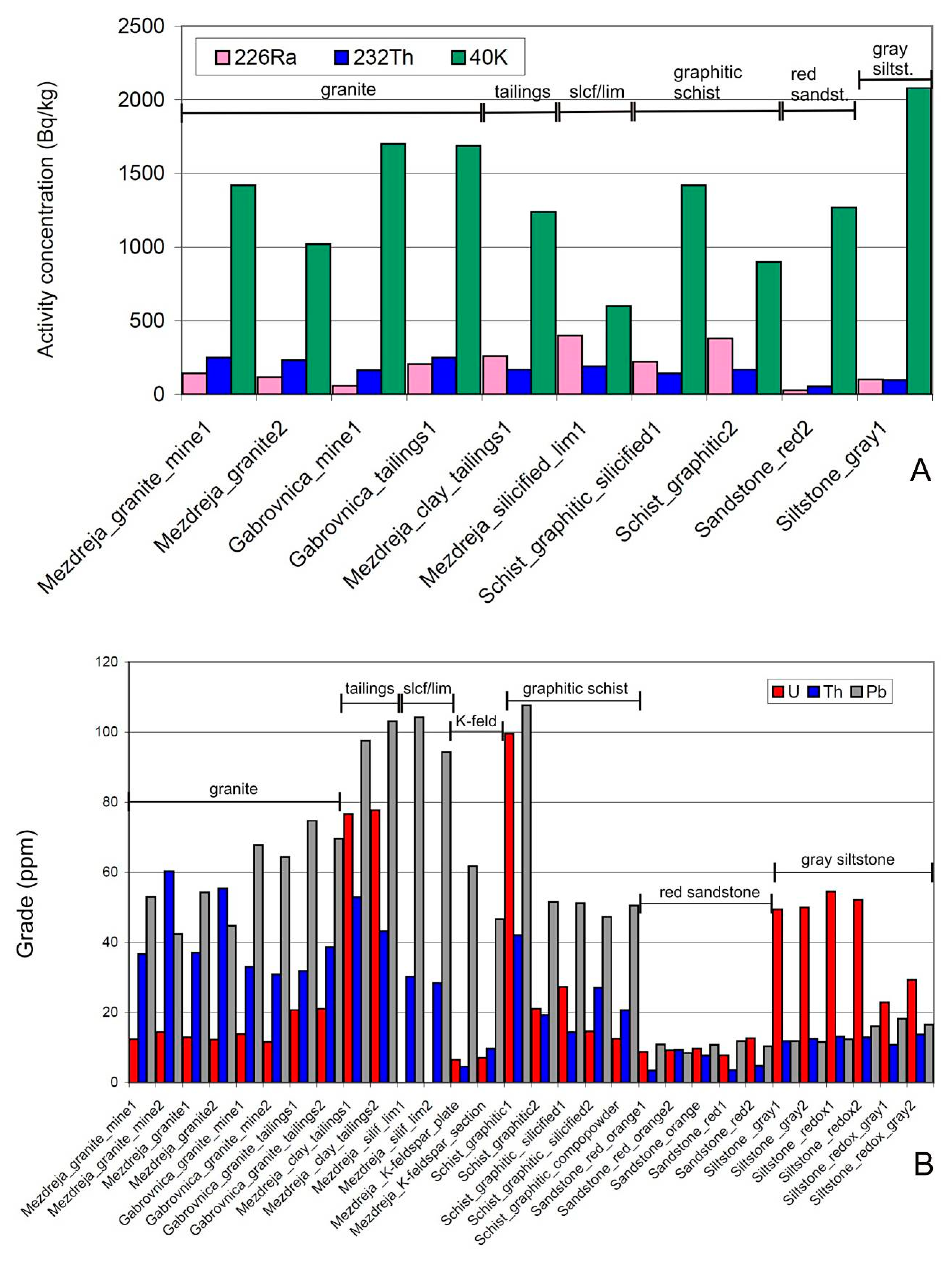
Figure 5 shows graphics of activity concentrations of
226Ra,
232Th and
40K and of U, Th and Pb grades. They refer to the text that follows.
The concentrations of uranium in the granite samples from Mezdreja and Gabrovnica were always lower than those of thorium by a factor of 3–4. At Mezdreja, the uranium concentrations varied from 12.21 to 14.39 ppm and those of thorium from 36.63 to 60.27 ppm. Radioactivity (
226Ra in Bq/kg) of the granites near the Mezdreja mine and at the mine portal measured 116 ± 5 and 142 ± 7, while
232Th was 230 ± 10 to 250 ± 10 Bq/kg. At Gabrovnica, the concentrations of uranium were from 11.61 to 21.09 ppm and of thorium from 30.82 to 38.66 ppm. Here the radioactivity (
226Ra) of the granite samples from the mine portal area were 58 ± 3 and of the granite samples from the mine dump 206 ± 9. The measured
232Th radioactivity of the mine portal granite was 163 ± 8 Bq/kg and of the mine dump granite 250 ± 10 Bq/kg. Hence, in both cases (Mezdreja and Gabrovnica), the thorium concentrations and radioactivity were higher than those of uranium. It should be noted that the concentrations of Pb at Gabrovnica were somewhat higher (from 64.27 to 74.66 ppm) than at Mezdreja (from 42.39 to 54.15 ppm). The grades of U and Th in the granite samples from Mezdreja and Gabrovnica were higher than in samples from volcanic islands of the Southern Tyrrhenian Sea, where U varied from 8.2 to 9.8 ppm and Th from 20.6 to 27.8 ppm [
21]. It should be noted that Stromboli, Salina, Filicuidi and Panarea are Late Quarternary and the Janja granite is Silurian. In addition, in eastern Mongolia (Berkh region) uranium anomaly No. 246 is alkaline biotite granite porphyry of middle-to-late Jurassic age, with 67 ppm U and 23 ppm Th [
22], including silicified and kaolin altered parts like in the Janja granite deposits.
Assays of coarse-grained pink K-feldspar sampled at Mezdreja, from the point of contact between the gabbroids and granites, showed that the concentrations of uranium were low (from 6.5 to 6.99 ppm), while those of Th varied from 4.56 to 9.72 ppm. The sample was a 2-cm solid grain, tested at the basis and section.
The concentrations of uranium in the clayey and kaolinized material from the Mezdreja mine tailings were higher than in fresh granites, but still lower than in the graphite-rich schist. The values ranged from 76.54 to 77.65 ppm of U. In this case there was less Th than U; Th concentrations were from 43.17 to 52.91 ppm. The concentrations of lead were nearly double those in granites, from 97.48 to 103.06 ppm. With regard to radioactivity, this material measured the highest equivalent values for uranium
226Ra—2600 ± 100 Bq/kg. The radioactivity of
232Th was 169 ± 2 Bq/kg and correlated with the values measured in the Mezdreje and Gabrovnica granites. This particular sample exhibited the highest radioactivity of
137Cs (10.8 ± 0.5 Bq/kg), compared to all the other samples tested in the research. In the granites,
137Cs measured 2.3 ± 0.1 at the pit and 4.8 ± 0.3 Bq/kg at the mine dump. The values of
137Cs at Mezdreja were low (less than 0.6 Bq/kg). In clay minerals, U enrichments are in illite-bearing uranium ore from Baiyanghe [
23] and the uranium mineralization is located near the fracture zone, which represents the center of hydrothermal fluid activity or mineralization, similar to the Mezdreja mine.
No uranium (LOD) was found in a sample of silicified-limonitic material from Mezdreja (slcf/lim on
Figure 5B). The concentration of thorium was from 28.42 to 30.25 ppm, and of lead from 94.31 to 104.22 (i.e., higher than in the other endogenous products tested). It is interesting to note that this sample measured the highest concentrations of cadmium (311.72–352.69 ppm). The radioactivity of
226Ra was 400 ± 20 Bq/kg and of
232Th 188 ± 9.
A highly-silicified sample from Mezdreja measured the highest concentration of strontium—from 1850.9 to 1962.7 ppm. In the samples from Mezdreja and of the monomineral pink K-feldspar, the concentrations were from 634.69 to 840.98 ppm and from 655.11 to 665.36 ppm, respectively. The Sr concentrations in the Gabrovnica granites were lower and ranged from 186.94 to 308.1 ppm.
In the endogenous group, specifically in the case of the Mezdreja and Gabrovnica granites and ore deposits, feldspar and mica minerals are the most important in terms of uranium concentrations. Given that the concentrations of uranium in the main petrogenic minerals are rather low, and the total amounts of such minerals and their spread large, they represent sources from which “hot” granites leach considerable concentrations of uranium. Uranium occurs as U
4+ in biotite, muscovite and minerals from the feldspar group. If these minerals have been altered under the influence of oxygen-rich hydrothermal or meteoric waters [
24], uranium in the form of U
6+ (as the U
6+O
2 ion) might be present in them, as well as in accessory minerals: sphene, zircon, monazite, ortite, xenotime, apatite, tourmaline, apatite [
25] and others.
Since uranium is remobilized from the primary granite at Mezdreja and Gabrovnica, it should be noted that in the presence of water and the H
+ ion: (1) kaolinite, the K
+ ion, U
4+ uranium ion and orthosilicilic acid are created from the primary “uranium-bearing” K-feldspar; and (2) sericite, K
+ ion, UO
22+ uranyl ion and again orthosilicilic acid might be formed. White mica (sericite) alteration has been observed in petrologic samples from Mezdreja and Gabrovnica (
Figure 2C,D). In the samples collected as part of the present research, sericitization was more pronounced at Mezdreja than at Gabrovnica. Biotite, another primary “uranium-bearing” mineral in granite, can also be transformed in two ways: (1) when the negative OH
− ion is present, creating sericite, silicon dioxide, water, aluminum silicate (which may occur as andalusite, kyanite or sillimanite), K
+ ion and U
4+ uranium ion; and (2) in the presence of water and the H
+ ion creating sericite, aluminosilicate, K
+ ion and UO
22+ uranyl ion.
The highest concentration of uranium in all samples was measured in the graphitic schist of the Inovo Series, rich in graphitic (organic) material (
Figure 3C,D), and it amounted to 99.47 ppm, as opposed to the schist samples from the same sequence that were richer in silicate material (
Figure 5B), which measured less uranium by a factor of nearly 4 (20.99–27.31 ppm). The concentration of Th was generally lower than that of U. The graphite-rich samples had nearly half the Th.
The samples that contained more silicate material had Th concentrations varying from the ratio 1:2 in favor of uranium to the same ratio in favor of thorium. The highest measured concentration of Th was 42.01 ppm in a graphite-rich sample. The concentration of lead varied from 47.33 to 51.55 ppm and was similar to the lead concentrations in the granites, particularly at Mezdreja where 107.69 ppm of Pb was exceptionally measured in graphitic schists (which exhibited the highest uranium concentrations). Radioactivity was measured in both cases. In the graphite-rich schist 226Ra was 380 ± 20 and in the graphite-poor schist 220 ± 10 Bq/kg, which correlated with the concentrations of U measured by XRF. The radioactivity of 232Th in the graphite-rich schist was 169 ± 8 and in the graphite-poor schist 141 ± 7 Bq/kg. The radioactivity of 137Cs was 3.7 ± 0.2 in the graphite-poor sample.
It should be noted that a household water well is located approximately 200 m from the observation point, in the vicinity of a river, so that the water should be tested for uranium as carried out in Montana [
26].
The highest Sr concentrations were noted in the graphitic schists of the Inovo Series with less organic material and the grade was 244.78 ppm.
Elevated concentrations of uranium in graphite schist are a result of redistribution of ore components under dynamic-thermal metamorphism conditions.
All the gray siltstones of the Multicolored Series measured uranium concentrations from 49.36 to 54.43 ppm. In this case the concentrations of thorium were lower by a factor of about 4 (from 11.83 to 13.13 ppm). Lead concentrations were similar to those of Th and ranged from 11.59 to 18.18 ppm. These samples exhibited somewhat elevated concentrations of Ba (from 590.14 to 603.42 ppm). The radioactivity of 226Ra was relatively low (102 ± 5 Bq/kg) and 232Th measured 97 ± 5 Bq/kg. The radioactivity of 40K was relatively high (2080 ± 90 Bq/kg). The values of 40K of the other samples were lower and ranged from 900 ± 40 to 1700 ± 80 Bq/kg (the lowest in the case of a highly silicified sample with limonite stains collected near Mezdreja).
The red sandstones of the Multicolored Series measured relatively low concentrations of uranium (
Figure 5B), from 7.78 to 12.64 ppm, and of thorium from 3.42 to 9.25 ppm. Lead concentrations varied from 8.42 to 11.81 ppm. These samples measured the lowest radioactivity of
226Ra—28 ± 1, and
232Th was 52 ± 3 Bq/kg.
In all sedimentary units the concentrations of strontium were much lower (in relation to granite and graphite schist samples) and generally varied from 90 to 120 ppm.
By way of an explanation of the uranium concentrations in the red members (mainly sandstone) of the Multicolored Series, it should be noted that the reduction of mobile uranium (U
6+) to insoluble uranium (U
4+), such as uraninite, takes place when the fugasity of oxygen in solution drops. This reaction occurs on account of iron or sulfur oxidation. When the solution (water) is rich in oxygen, bivalent iron will oxidize into trivalent iron, but if there is an excess of Fe
2+ relative to the oxygen, the oxygen will be spent and the uranyl ion is the one to convert bivalent iron into trivalent, or sulfides to sulfates, and is itself precipitated as uraninite. It is known in geology that iron oxidation in nature can result in uranium-bearing hematite [
27]. The typical red color is attributed to Fe hydroxides, largely deposited as cement. Their widespread presence suggests considerable incoming Fe from the Zaglavak gabbroids (granites carry a much smaller amount of Fe).
Uranium concentrations in the case of “Multicolored Series” sediments (gray siltstone) are attributable to adsorption to clays and organic-coaly material (well described in Wang et al. [
28]). This process takes place in the presence of specific adsorbents such as clay minerals, limonite, carbonate sediments or organic substances, humic acid or caustobiolites, with which the uranium-bearing solution comes into contact. Muto et al. [
29] tested uranium adsorption to the clays commonly found in nature: montmorillonite, haloizite and kaolin. The results they reported show that uranium is fixed most efficiently at pH from 6.1 to 6.2.
In the Dojkinci area, pH measured in the river was about seven, locally 7.4. In addition, in the Dojkinci–Jelovica area uranium migrativity and a reduction environment have been noted [
30]. Uranium is being deposited in a reduction environment, after the change of redox conditions. Organic substances are the major reducers of uranium, followed by iron compounds and clay minerals [
31]. In the zone of the geochemical barrier in Permo-Triassic sediments, pH levels of water recently measured about seven and Eh about 140 mV.


