Article

Formation Mechanism of Granitic Basement Reservoir Linked to Felsic Minerals and Tectonic Stress in the Qiongdongnan Basin, South China Sea

1
CNOOC China Limited, Hainan Branch, Haikou 570312, China
2
State Key Laboratory of Oil and Gas Reservoir Geology and Exploitation, Chengdu University of Technology, Chengdu 610059, China
*
Authors to whom correspondence should be addressed.
Minerals 2025, 15(5), 457; https://doi.org/10.3390/min15050457
Submission received: 18 March 2025 / Revised: 11 April 2025 / Accepted: 25 April 2025 / Published: 28 April 2025

Abstract

:
Recent exploration efforts in the Qiongdongnan Basin have revealed hydrocarbon resources within granitic basement rocks in buried hill traps. However, the formation mechanisms and primary controlling factors of these reservoirs remain poorly understood. In this study, we utilized data from six wells in the Qiongdongnan Basin, including sidewall cores, thin sections, imaging logging, and seismic reflection profiles, to analyze the petrological characteristics, pore systems, and fracture networks of the deep basement reservoir. The aim of our study was to elucidate the reservoir formation mechanisms and identify the key controlling factors. The results indicate that the basement lithology is predominantly granitoid, intruded during the late Permian to Triassic. These rocks are characterized by high felsic mineral content (exceeding 90% on average), with them possessing favorable brittleness and solubility properties. Fractures identified from sidewall cores and interpreted from image logging can be categorized into two main groups: (1) NE-SW trending conjugate shear fractures with sharp dip angles and (2) NW-SE trending conjugate shear fractures with sharp angles. An integrated analysis of regional tectonic stress fields suggests that the NE-trending fractures and associated faults were formed by compressional stresses related to the Indosinian closure of the ancient Tethys Ocean. In contrast, the NW-trending fractures and related faults resulted from southeast-directed compressional stresses during the Yanshanian subduction event. During the subsequent Cenozoic extensional phase, these fractures were reactivated, creating effective storage spaces for hydrocarbons. The presence of calcite and siliceous veins within the reservoir indicates the influence of meteoric water and magmatic–hydrothermal fluid activities. Meteoric water weathering exerted a depth-dependent dissolution effect on feldspathoid minerals, leading to the formation of fracture-related pores near the top of the buried hill trap during the Mesozoic exposure period. Consequently, the combination of high-density fractures and dissolution pores forms a vertically layered reservoir within the buried hill trap. The distribution of potential hydrocarbon targets in the granitic basement is closely linked to the surrounding tectonic framework.

1. Introduction

The concept of “Buried Hill” was first introduced by petroleum geologists in 1922 during oil exploration activities in Pennsylvania, United States [1]. A buried hill refers to a granite mountain underlying an unconformity surface, characterized by older, steeper strata that are of great geological significance for oil and gas. Based on lithology, buried hills are classified into four main types: granite-buried hills, carbonate-buried hills, metamorphic-buried hills, and volcanic-buried hills [2]. To date, large- and medium-sized oil and gas reservoirs have been discovered in buried hills of various lithologies. In basins with favorable hydrocarbon source conditions, in particular, the exploration of basement rocks within buried hills has become a critical focus [3]. In the Bohai Bay Basin in China, significant breakthroughs have been achieved in hydrocarbon exploration across all types of buried hill traps [4,5,6,7,8,9,10,11,12]. Exploration of granite-buried hill reservoirs, in particular, has led to numerous discoveries worldwide [13,14]. Notable examples include the Eldorado Oilfield in the United States [15]; the Precambrian granite-buried hill of the Ogira Oilfield in the Sirte Basin, Libya [16,17,18]; the Baihu Oilfield in the Cuu Long Basin, Vietnam [19]; the Daxiong Oilfield [20,21]; the Mesozoic granite-buried hill of the Penglai 9-1 Oilfield [22]; the Dongping area in the Qaidam Basin [23]; and the Huizhou Sag in the Pearl River Mouth Basin [24,25].
In recent years, several gas reservoirs have been discovered in buried hill traps within the Qiongdongnan Basin [26,27]. A vertical zoning reservoir model for these buried hill traps in the Songnan Low Uplift, Qiongdongnan Basin, has been established, highlighting lithology and weathering as two critical influencing factors. In addition, the structural attributes and evolutionary processes of these buried hills have been reconstructed [27,28,29,30]. The high felsic brittle mineral content in these rocks provides favorable material conditions for fracture formation [31]. While weathering and tectonism are widely recognized as the primary factors controlling reservoir development [32,33], the specific tectonic events contributing to fracture formation remain poorly understood.
In this study, we focus on six wells across three buried hill traps in the Qiongdongnan Basin (Figure 1), aiming to elucidate the factors responsible for the formation of granite reservoirs and their implications for hydrocarbon exploration.

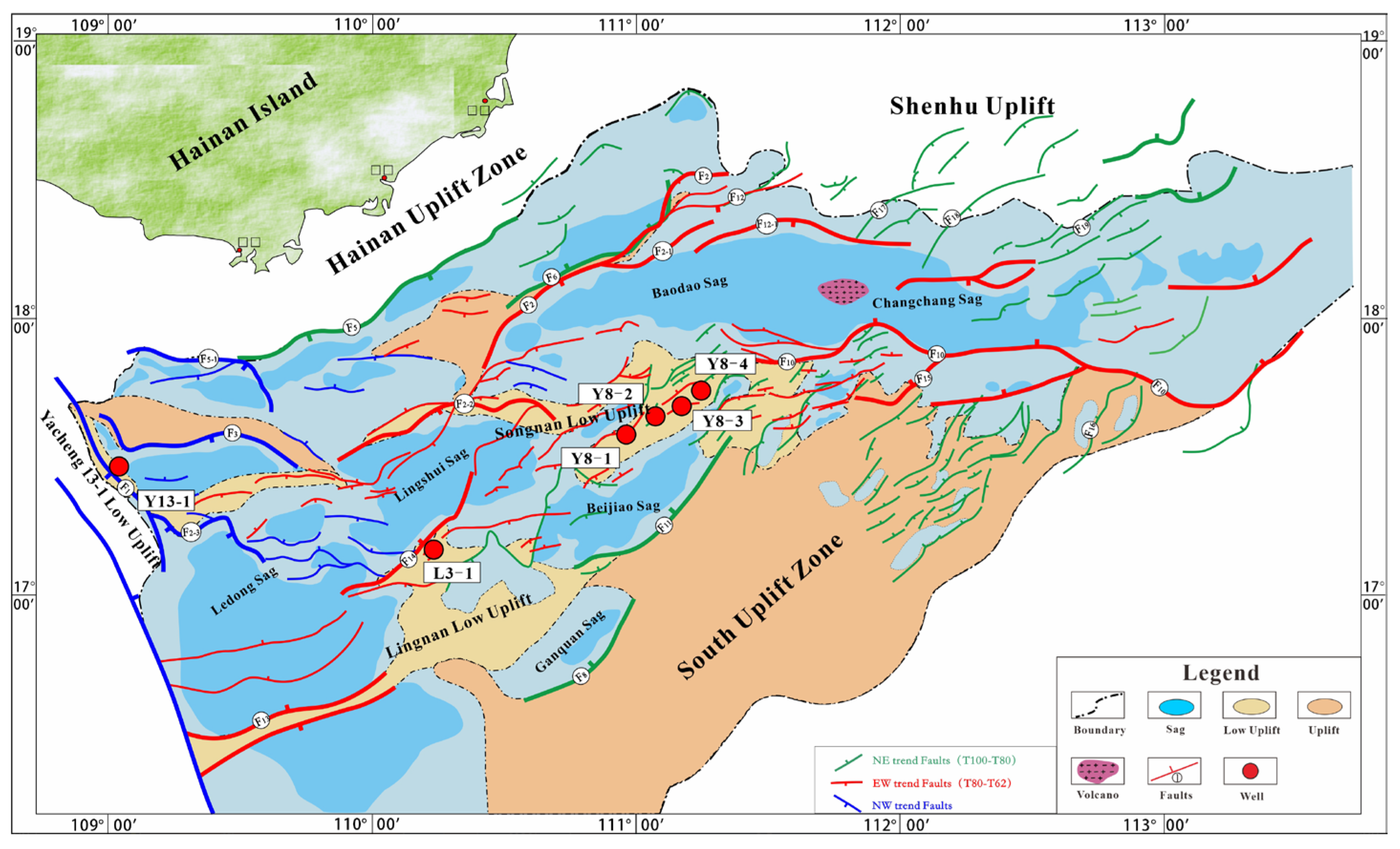
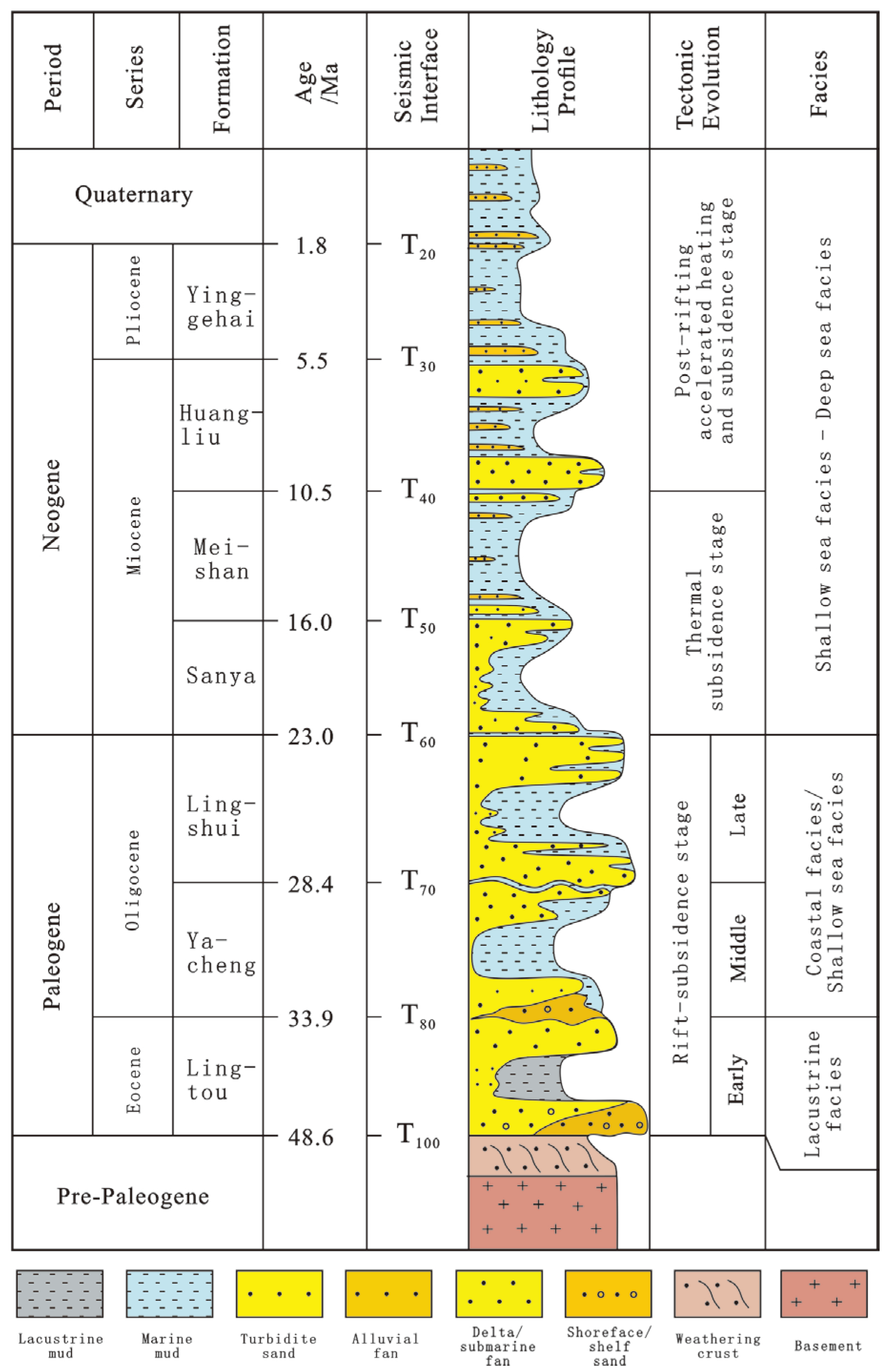
2. Geological Setting

The Qiongdongnan Basin is situated on the western side of the continental shelf along the northern margin of the South China Sea. The basin exhibits an overall NE-trending distribution and is bounded by the Yinggehai Basin to the west, which is dominated by a strike–slip fault system. To the east, it is separated from the Pearl River Mouth Basin by the Shenhu Uplift and a continental margin extensional fault system. The basin is flanked by the Hainan Island Uplift to the north and the Xisha Uplift to the south, covering an area of approximately 80,000 km2. Structurally, the basin is divided into four major zones from north to south: the northern depression zone, the northern uplift zone, the central depression zone, and the southern uplift zone. These zones are further subdivided into nine sags and seven low uplifts or uplifts (Figure 1) [34,35,36].
In terms of stratigraphy and sedimentation, the Qiongdongnan Basin is characterized by a sedimentary filling sequence primarily composed of Paleogene, Neogene, and Quaternary deposits (Figure 2). The maximum sedimentary thickness exceeds 12,000 m. The stratigraphic sequence, from bottom to top, includes the Yacheng Formation and Lingshui Formation of the Eocene and Oligocene; the Sanya Formation, Meishan Formation, and Huangliu Formation of the Miocene; the Yinggehai Formation of the Pliocene; and the Ledong Formation of the Quaternary. The tectonic evolution of the basin has been influenced by multiple tectonic domains, including the Paleo-Tethys, Paleo-Pacific, Neo-Tethys, and Paleo-South China Sea [37]. The Indosinian closure of the Paleo-Tethys Ocean and the Yanshanian subduction of the Paleo-Pacific Plate led to the widespread development of Middle Paleozoic magmatic basements in the study area. In contrast, Cenozoic tectonic activity primarily controlled basin formation, simultaneously generating two sets of boundary fault systems trending NE-SW and N-S. The transition of tectonic domains also provided the stress conditions necessary for the development of buried hill reservoirs.
The basement of the Qiongdongnan Basin is predominantly composed of Mesozoic and Cenozoic granites, with localized occurrences of metamorphic and volcanic rocks. These lithologies provide favorable conditions for the development of buried hill reservoirs. In recent years, extensive drilling has been conducted in the buried hills of the basin, leading to significant discoveries in structural traps such as the Yacheng 13-1 Low Uplift, the Lingnan Low Uplift, and the Songnan Low Uplift. These industrial discoveries have provided a wealth of research data and a solid foundation for further studies on buried hill reservoirs in the Qiongdongnan Basin.

3. Methods

In this study, we utilized drilling and logging data from six wells located in three major structural belts within the Qiongdongnan Basin. The wells include Y8-1, Y8-2, Y8-3, and Y8-4 in the Songnan Low Uplift; L3-1 in the Lingnan Low Uplift; and Y13-1 in the Yacheng 13-1 Low Uplift. The data comprise drilling cores, cuttings, element logging data, and geophysical logging curves. To ensure that we assessed the key factors (including lithology and structural characteristics) that have the strongest impact on the buried hill reservoir, we utilized the methods described below.

3.1. Microscopic Analysis of Thin Sections

Microscopic observation and statistical analyses were conducted at the National Key Laboratory of Oil and Gas Reservoir Geology and Development Engineering, Chengdu University of Technology. Thin sections were examined to identify and quantify different mineral components (e.g., quartz, feldspar, and dark minerals). In addition, the development and filling characteristics of fractures were observed and documented under a microscope. Totally, 33 samples from 6 wells were collected and 33 thin sections were examined.

3.2. Seismic Structure Interpretation

Three-dimensional seismic structure analysis was conducted at the Research Institute of CNOOC Hainan Branch. Landmark DSG 10 was used for loading and interpretation of the processed 3D seismic data volume. First, combined with the drilling calibration, T100 was calibrated by using the apparent wave impedance interface between the Cenozoic strata and the pre-Cenozoic strata in the seismic data. Second, the pre-Cenozoic buried hill was imaged, and its boundary faults were interpreted. Third, the fault structural elements (dip angle and fault throw) were counted by using typical sections, and the angle between fault strike, density, and current in situ stress was measured on the T100 plane.

3.3. Well Logging Data Analysis

3.3.1. Statistics of Fracture Characteristic Elements

Fracture characterization was conducted using imaging logging data acquired by the Schlumberger Company during the drilling process. Processed imaging logging data were interpreted using Techlog 2022. The fracture can be divided into 3 types, including tectonic fractures, dissolution fractures, and diagenetic fractures, based on their different characteristics from the imaging logging. The tectonic fractures are large in scale, characterized by continuous longitudinal development, relatively long lengths, and smooth fracture surfaces. The dissolution fractures have a smaller development scale, occurring in the areas with a relatively shallow depth in the buried hill, and their fracture surfaces are uneven. The diagenetic fractures have the smallest development scale, often only developing within a single rock layer and showing poor continuity. The fracture interpretation and density calculations were performed based on this set of data: (1) For different types of fractures, characteristic information (e.g., strike, dip angle, and length) was extracted and statistically analyzed, and (2) fracture density was calculated using data from the entire well section.

3.3.2. Geological Data from Drilling Wells

The reservoir stratification of the buried hill was determined through a comprehensive analysis of element logging and drilling speed data. A sudden decrease in fluid-mobile elements (e.g., K and Na) in the element logging data and a reduction in drilling speed upon entering the buried hill zone were used as key indicators. Gas layer data and reservoir physical parameters were derived from the integration of drilling gas logging data and logging interpretation results. The net-to-gross ratio was calculated based on logging interpretation statistics.

4. Results

4.1. Lithology and Fracture Characteristics

The basement lithology of the six drilled buried hills is primarily granite, including granodiorite, monzonitic granite, syenite, and granite and a few intermediate–basic rock interlayers, such as diabase (Figure 3).
(1)
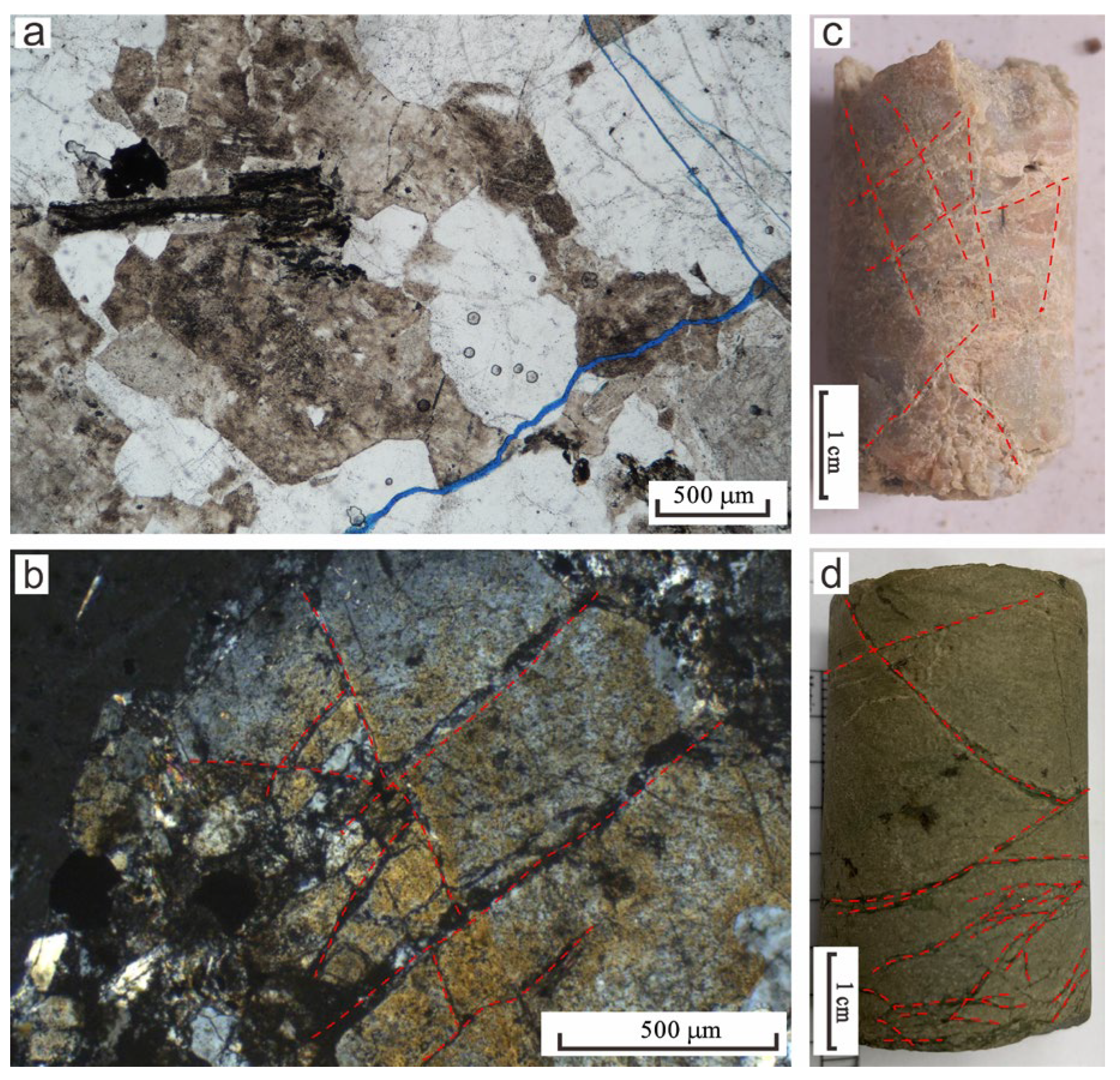
Granodiorite: The buried hill granodiorite in the Qiongdongnan Basin is widely developed. It is developed in Well L3-1 (depth of 4235~4244 m) and Well Y13-1 (depth of 3606~3620 m). Its microscopic characteristics are as follows: with a granite structure, the mineral composition is mainly plagioclase, alkaline feldspar, quartz, a small amount of biotite, muscovite, and iron; the rock contains multiple directional micro-cracks and is mostly filled with pyrite, and local mineral particles are broken in a network.
(2)
Monzonitic granite: The monzonitic granite in the buried hill of the Qiongdongnan Basin is widely developed. It is developed in Well Y8-1 (depth 2922~3054 m), Well Y8-2 (depth 3354~3492 m), Well Y8-3 (depth 2834 m~2986 m), Well Y8-4 (depth 2890~2939 m), Well L3-1 (depth 4328~4338 m), and Well Y13-1 (depth 3570~3610 m). The microscopic characteristics comprise a granite structure, mainly composed of plagioclase, alkaline feldspar, quartz, a small amount of biotite (less than 5%), and iron; biotite and plagioclase are mostly euhedral and subhedral, and alkaline feldspar and quartz are mostly subhedral and anhedral. The weathering of plagioclase is strong, and the surface clay and sericite are present. Alkaline feldspar is mainly striped feldspar, and the surface is clean; a small amount of quartz is granular, with a gray–white interference color and wavy extinction; black mica is brown scaly; iron is granular opaque; the rock develops multiple directional micro-cracks which are partially filled with pyrite, and the crystals are locally fractured, forming a network.
(3)
Syenite: The syenite in the buried hill of the Qiongdongnan Basin is less widely distributed. It is mainly found in Well Y8-1 (depth of 2974 m) and Well Y8-2 (depth of 3490 m). Its microscopic characteristics comprise a granite structure, mainly composed of alkaline feldspar and plagioclase and a small amount of quartz and biotite, epidote, and opaque minerals. Clayization is mostly developed on the surface of feldspar, and calcite vein filling can be seen.
(4)
Granite: Buried hill granites are widely distributed in the Qiongdongnan Basin. They are developed in Well Y13-1 (depth 3650~3690 m) and Wells Y8-3 and Y8-4 (depths 2897 m and 2969~2972.25 m). Its microscopic identification features are as follows: granite structure, massive structure; the main minerals are feldspar, quartz, and a small amount of biotite; this type of feldspar contains plagioclase and alkali feldspar. Plagioclase occurs as subhedral crystals, exhibiting polysynthetic twinning. It is predominantly altered to sericite and clay minerals, with minor alteration along crystal margins where the original cleavages and boundaries remain relatively preserved. The crystals consist of quartz, striped feldspar, orthoclase, and mica. Some crystals are altered; for example, orthoclase was altered to hydromica and kaolinite. Most of the mica is altered, and some is altered into chlorite.
(5)
Diabase: Diabase in the Qiongdongnan Basin is found in the basement of Well L3-1. It is developed as interlayers. The microscopic characteristics comprise a diabase structure, and the mineral composition is mainly plagioclase, pyroxene, and a small amount of quartz; plagioclase is subhedral; it can be seen that some feldspars are filled with pyroxene in the triangular framework formed by disorderly arrangement, and pyroxene is colorless–light yellow, with high protrusions. A small amount of quartz is granular, characterized by a gray–white interference color, with wavy extinction.
In addition, the microscopic results of the granite show that some of the cracks are filled with siliceous veins (Figure 3g), pyrite veins, and calcite veins (Figure 3h). These veins are characterized by hydrothermal processes related to early magmatic activities, and clay mineral filling veins, chlorite veins, and some minerals are weathered and dissolved (Figure 3i), with these factors being closely related to the process of atmospheric freshwater leaching after the uplift and denudation of the buried hill [26]. The former will lead to the filling and destruction of granite reservoir space, whereas the latter provides a favorable environment for the development of reservoir space [26,29].
Sidewall core observations and thin-section analyses reveal extensive fracture development from the top to the interior of buried hills in the Qiongdongnan Basin. These fractures are categorized into tectonic fractures, dissolution fractures, and diagenetic fractures (Figure 4), all constituting critical reservoir spaces at varying scales. Felsic magmatic rocks, under tectonic stress, preferentially develop multiple sets of conjugate fractures resembling micro-faults (Figure 4b), with extensive fracture surfaces serving as primary contributors to the fracture systems. Furthermore, some fractures observed in borehole cores and thin sections exhibit dissolution enlargement and mineral filling, reflecting multi-stage fluid–rock interactions (Figure 4c,d).
Based on the microscopic observation results of rock slices, the mineral composition of basement granites at different depths in the six wells was statistically analyzed. The statistical results show that the felsic mineral content in the basement lithology of Well Y8-1 in the Songnan Low Uplift is 84%~98%, and the dark mineral content is 2%~14%. The felsic mineral content in the basement lithology of Well Y8-2 is 77%~95%, and the dark mineral content is 2%~19%. The felsic mineral content in the basement lithology of Well Y8-3 is 82%~88%, and the dark mineral content is 2%~19%. The felsic mineral content in the basement lithology of Well Y8-4 is 85%~92%, and the dark mineral content is 5%~8%. The felsic mineral content in the basement of Well L3-1 in the Lingnan Low Uplift is 88%~96%, and the dark mineral content is 1%~10%. The felsic mineral content in the basement lithology of Well Y13-1 in the Yacheng 13-1 Low Uplift is 85%~96%, and the dark mineral content is 3%~8%.

4.2. Structural Characteristics

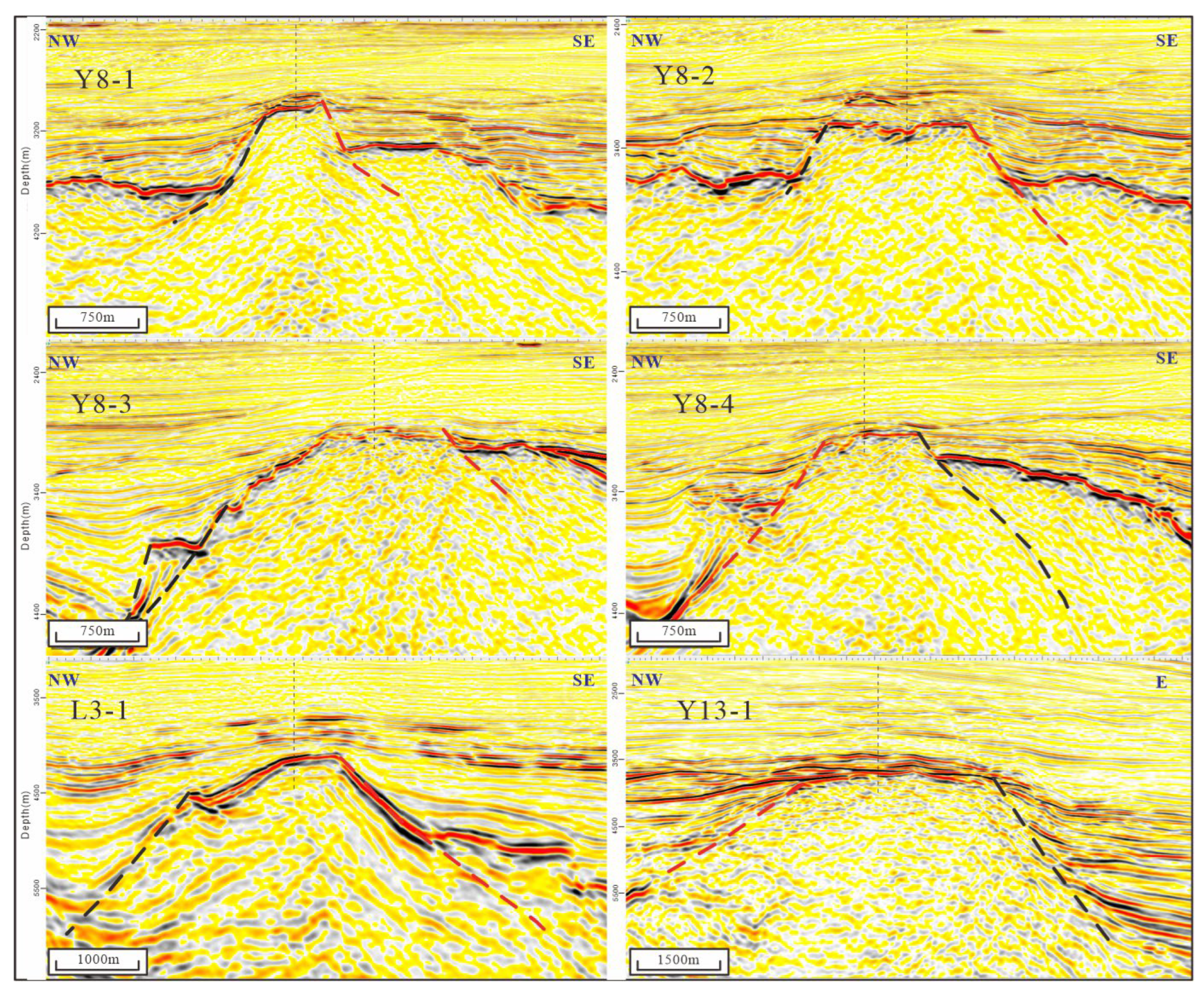
4.2.1. Structural Elements of the Buried Hill Boundary Fault

The boundary faults of buried hills are predominantly normal faults, and the target reservoirs within these buried hills are typically located on the hanging wall of these normal faults. To further investigate the relationship between the degree of fracture development in buried hill reservoirs and the boundary faults of the buried hills, the seismic profile interpretations (Figure 5) were utilized.
These key parameters, including the fault dip, dip angle, fault distance, fault density, the angle between the fault strike and the current in situ stress direction, and the distance between drilling locations and the fault, provide a foundation for subsequent analysis of the main structural elements controlling the reservoir. The key elements from the six wells are presented in Table 1, including fault strike, dip direction, dip angle, the angle between fault strike and maximum horizontal stress, fault throw, fault density, and distance from the well to the boundary fault.

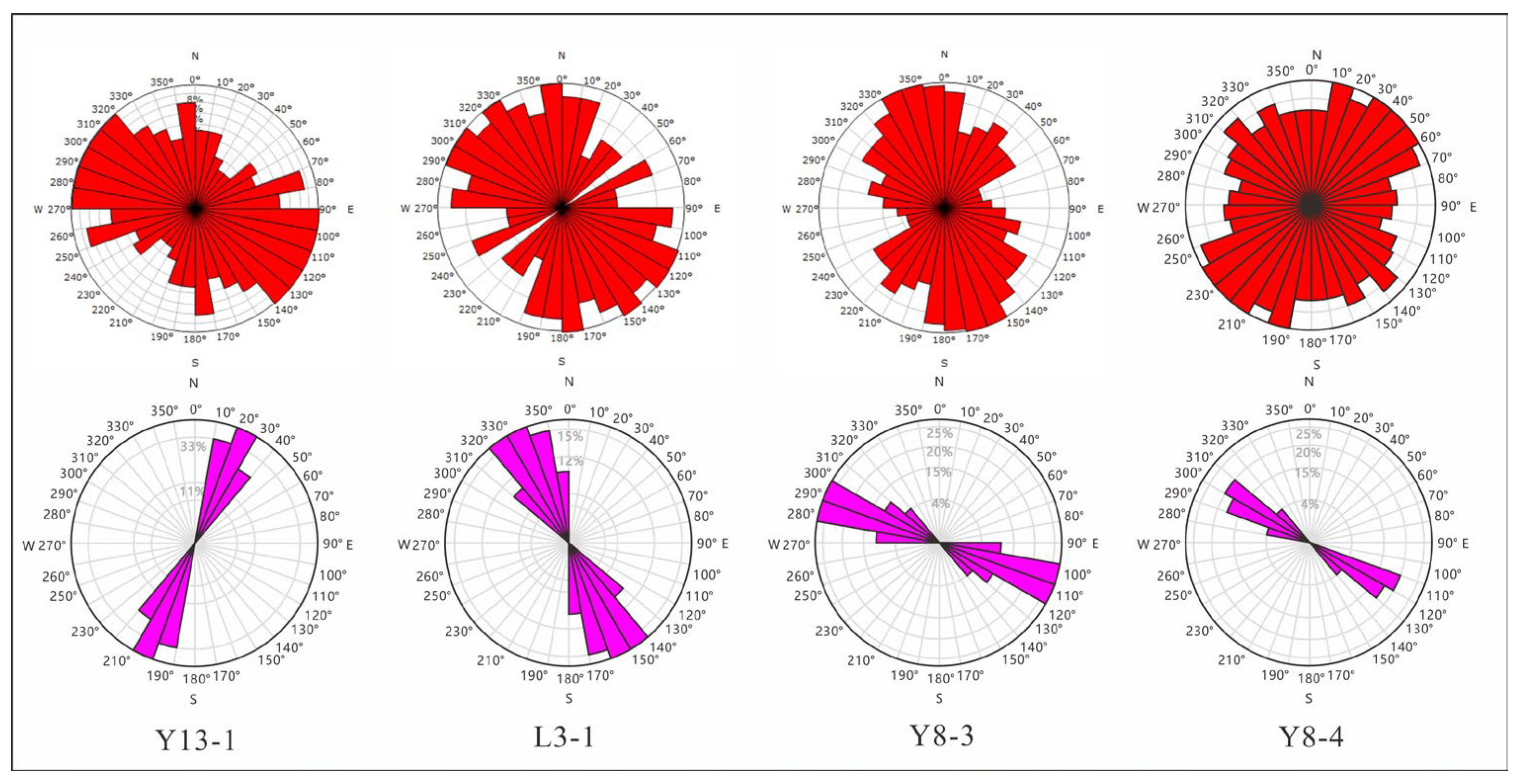
4.2.2. Fracture Occurrence Interpretation from Imaging Logging

The structural parameters of macroscopic boundary faults were interpreted in detail based on seismic data. Due to the lack of drilling cores, the microscopic fracture structural parameters are scarce. In this study, imaging logging data were used to analyze the structural elements of the reservoir fractures in the buried hill section of four typical wells (Wells Y8-1 and Y8-2 lack imaging logging data). Imaging logging can aid in observing a variety of fractures according to different characteristics, including continuous fractures, discontinuous fractures, dissolution fractures, and induced fractures. In this study, the current in situ stress data were primarily derived from the corresponding drilling imaging logging-induced fractures. The continuous fracture is an important basis for characterizing the reservoir fracture parameters in this study. The continuous fractures are primarily relatively large structural fractures that extend to meters in length, formed in igneous rocks under greater stress. They are the most widely distributed, most extensively studied, and most regularly found in rock. They regularly occur in groups. As shown in Figure 6, Well Y8-3 developed one group of continuous fractures with the dominant strike, and the strike was 150°~170°. Well Y8-4 developed three groups of continuous fractures with the dominant strike, and the strikes were 10°, 45°, and 140°, respectively. The angle between the 10° group of continuous fractures and the 45° group of continuous fractures is acute, and the strike is primarily in the northeast direction. Two groups of continuous fractures with dominant strikes developed in Well L3-1, with strikes of 110°~150° and 170°~190°, respectively. The angle between the two is acute and points to the NW direction. Well Y13-1 primarily develops two sets of continuous fractures with dominant strikes. The strikes are 90°~130° and 175°, respectively. The 90°~130° fractures can be divided into two subgroups. The angle between the fractures of these two subgroups is acute and points to the NW direction.

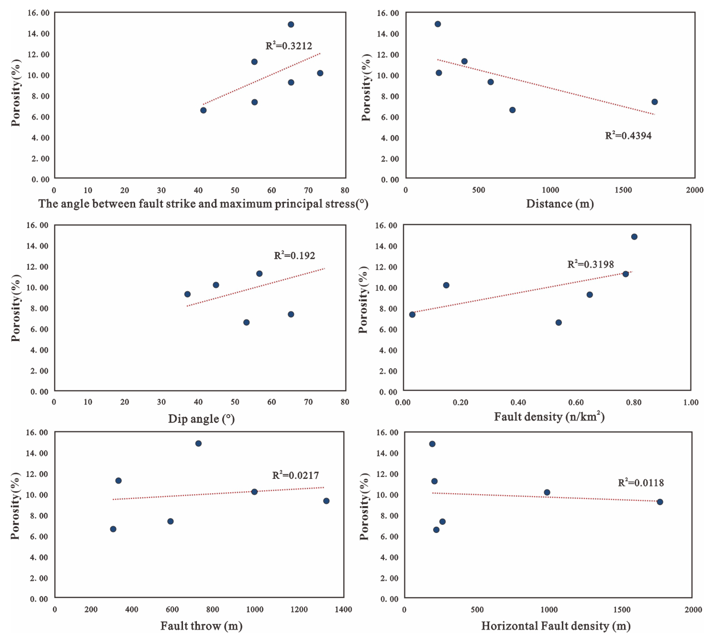
4.3. The Physical Properties of the Basement Reservoir and Its Zoning

In igneous rock reservoirs, permeability and net-to-gross ratio are often used to preliminarily evaluate the quality of such reservoirs. These two parameters were therefore selected as the evaluation parameters of reservoir quality in this study. From Table 2, it can be seen that in Well Y8-1, only the weathering fracture zone was drilled into and not the internal fracture zone. Its logging porosity is 14.9%, which also represents the porosity of Well Y8-1, which involved drilling into the buried hill section as a whole, and its net-to-gross ratio is 0.65. The weathering fracture zone and internal fracture zone are developed in Well Y8-2, and their weathering fracture zone porosity, inner crack zone porosity, whole reservoir porosity, and net-to-gross ratio are 6.6, 5.9, 6.3, and 0.53, respectively. The weathering fracture zone and internal fracture zone are developed in Well Y8-3, and their weathering fracture zone porosity, inner crack zone porosity, whole reservoir porosity, and net-to-gross ratio are 9.3, 10.1, 9.5, and 0.7, respectively. Well Y8-4 developed a weathering fracture zone and internal fracture zone, and their weathering fracture zone porosity, inner crack zone porosity, whole reservoir porosity, and net-to-gross ratio were 11.3, 8.7, 9.7, and 0.9, respectively. The weathering fracture zone and the internal fracture zone are developed in Well L3-1, and their weathering fracture zone porosity, inner crack zone porosity, whole reservoir porosity, and net-to-gross ratio are 10.2, 5.5, 6.3, and 0.5, respectively. The weathering fracture zone and the internal fracture zone are developed in Well Y13-1, and the weathering fracture zone porosity, inner crack zone porosity, whole reservoir porosity, and net-to-gross ratio are 7.4, 6.5, 6.8, and 0.8, respectively.

5. Discussion

In general, the basement reservoir is vertically divided into a soil–sand–gravel zone, a weathering fracture zone, a fracture zone, and a bedrock zone from top to bottom, which can be comprehensively interpreted using geological, geophysical, and geochemical data and other approaches [22,38,39,40,41,42,43,44,45]. The key factors that induced this layered architecture include lithology, tectonic stress, and weathering leaching [46,47,48,49,50]. In this case, the main type of rock in the buried hills in the Qiongdongnan Basin is granite, which is a favorable factor in the formation of a second storage space. The most important thing is that these granite plutons experienced compressional tectonic events and a following extensional stress setting.

5.1. The Felsic Minerals Contributing to Brittleness and Solubility

Higher content of unstable minerals, which are easily weathered and dissolved, is thought to aid in the formation of the second dissolution pores for basement rocks [51]. The results of the rock mechanics experiments show that the rocks with high unstable dark mineral content exhibit stronger ductility than those with low unstable dark mineral content. This factor leads to the latter forming fractures more easily under the same tectonic stress conditions [52]. As is widely recognized, light-colored feldspar minerals are soluble minerals characterized by brittleness [53,54,55,56,57,58,59,60]. The microscopic observation results of buried hill lithology and the statistical results of mineral components show that the buried hills of the Songnan Low Uplift, Lingnan Low Uplift, and Yacheng 13-1 Low Uplift in the Qiongdongnan Basin mainly develop granitic plutonic intrusive rocks, and the felsic minerals content is generally more than 80%. Because felsic minerals are more brittle and less ductile than ferromagnesian minerals, felsic minerals are more prone to form brittle fractures under pressure conditions. As such, the lithology of the three buried hill zones in the Qiongdongnan Basin has high felsic mineral content and low ferruginous mineral content, which provides a material basis for the formation of the fracture reservoir. The content of felsic minerals of the granitoid rocks in the three tectonic belts does not differ considerably. The felsic mineral content in the Songnan Low Uplift, Lingnan Low Uplift, and Yacheng 13-1 Low Uplift is 90%, 93%, and 91%, respectively. These findings therefore also indicate that high felsic mineral content is common among them, meaning that it is not the main factor responsible for differences in the buried hill reservoirs in the three tectonic belts.

5.2. Fracture Formation Linked to Multi-Stage Tectonic Activities

Recent research results regarding the geochronology of the buried hill granites in the western part of the Qiongdongnan Basin show that the lithologic granites in the basement of the buried hill are mainly concentrated in the Late Permian to Triassic [31]. After its formation, three major tectonic movements occurred against the backdrop of the closure of the Paleo-Tethys Ocean and the expansion of the South China Sea: Early Triassic Indosinian compressional orogeny, Yanshan thrust compressional activity, and Himalayan extension movement [61,62,63,64]. In this study, the strike of the continuous fractures of the four drilled imaging logging wells can be divided into the NE-trending X-type conjugate fracture group and the NW-trending X-type conjugate fracture group, which corresponds to the NE-trending compression in the Indosinian period and the NW-trending compression in the Yanshanian period. The acute angle direction of the conjugate shear fracture indicates the direction of the maximum principal stress of the extrusion, indicating that the granite-buried hill fractures in the western part of the Qiongdongnan Basin are likely to have been formed by the two tectonic activities of the late Indosinian and Yanshan periods. During the Himalayan period, the Qiongdongnan Basin underwent strong rifting from 33 Ma, forming a rift basin. Therefore, the boundary faults of the granite are also depression-controlling faults inside the basin. These fault activities will transform the fractures that formed in the basement earlier.
In general, the basement reservoirs are formed and controlled by three factors: lithology, structure, and fluid. The degree of tectonic transformation is the most important factor affecting the development of granite-buried hill reservoirs [51]. According to the tectonic evolution process of the uplift, it is believed that tectonics are mainly reflected in the occurrence and vertical development characteristics that control the development of fractures in the buried hill [65]. The unfilled or semi-filled structural fractures themselves can become effective reservoir space and also provide channel conditions for deep fluid and later organic acid dissolution into buried hill reservoirs [66].
The results of existing studies on buried hill reservoirs have demonstrated that fractures constitute a critical type of reservoir space in granite-buried hill reservoirs, and their development is often closely associated with fault activity. Although the results of previous studies have shown that the fracture orientation in the buried hills of the Bohai Bay Basin is relatively consistent with the strike of boundary faults [8,9,10,11,12], their relationship remains unclear in the Qiongdongnan Basin. The results of a study [67] by Barg and Skar (2005) highlight that normal faults generate associated fracture systems, with fracture density on the hanging wall exhibiting zonal characteristics. Specifically, fracture density is inversely proportional to the distance from the fault. Correlation analysis is a widely used method in the study of Earth science [68]. The correlation coefficient R2 can effectively indicate the correlation between the two elements. We analyzed the correlation between the structural elements of the boundary fault and the physical parameters of the buried hill. All six buried hills were developed with a weathering fracture zone, and some of them have not been drilled to the internal crack zone. We therefore selected the weathering fracture zone porosity to represent the physical parameters of the buried hill reservoir. The analysis results show that (Figure 7) the reservoir porosity is negatively correlated with the distance to the boundary fault, positively correlated with the fault density, and positively correlated with the angle between the boundary fault strike and the current maximum ground stress. However, no obvious correlation was found between the three structural elements of fault throw, tendency, and dip angle and reservoir physical properties.

5.3. The Formation Mechanism of the Basement Reservoir

Although buried hill reservoirs exhibit structural variations, they universally demonstrate tectonic–fluid synergistic control of reservoir development. The Bozhong 19-6 buried hill reservoir displays a tripartite vertical architecture (“weathered glutenite—strong weathered zone—weak weathered zone”), governed by the coupling mechanism between the structural stress concentration in fold hinge zones and the differential weathering of felsic minerals [69]. In contrast, the Bach Ho buried hill reservoir comprises a structurally fracture-dominated dual-layer configuration, relying on fracture systems generated by thrust fault networks, with a lack of significant weathered-modified layers [21]. The evolution of buried hill reservoirs in the Qiongdongnan Basin is controlled by lithology, multi-stage tectonics, and fluid interactions. The Indosinian–Yanshanian compressive phases established the fracture network framework: the closure of the Paleo-Tethyan domain during the Indosinian period induced NW-trending thrust fault systems, whereas the subduction of the Paleo-Pacific plate during the Yanshanian period generated NE-trending thrust systems. These compressive regimes promoted the development of NE-SW and NW-SE trend fracture sets in basement granites [26,27] (Figure 8). During the Cenozoic, the tectonic regime transitioned from compression to extension, triggering the inversion of pre-existing thrust faults and detachment faulting, which drove the structural differentiation of buried hills. Extensional stress facilitated fracture dilation and permeability enhancement. Meteoric water leaching during the uplift formed a weathering fracture zone at the top of the buried hill. Although the internal fracture zone exhibits weaker weathering–leaching intensity, it experienced superimposed hydrothermal dissolution and tectonic reworking. Consequently, a vertically stratified dual-layer reservoir architecture—comprising a weathering fracture zone and an internal fracture zone—was established (Figure 8).

6. Conclusions

From the findings presented above, the following conclusions can be drawn:
(1) The development of granitic basement reservoirs in the buried hill traps of the Qiongdongnan Basin is primarily controlled by tectonic activity. The basement lithology is dominated by granitoid rocks, which intruded during the late Permian to Triassic.
(2) The storage space within the basement reservoir is characterized by two sets of fractures: NE-SW trending and NW-SE trending. These fractures are associated with the Indosinian closure of the ancient Tethys Ocean and the Yanshanian subduction of the Paleo-Pacific plate, respectively.
(3) Meteoric water weathering exerts a depth-dependent dissolution effect on feldspathoid minerals, leading to the formation of fracture-related pores near the top of the buried hill trap during the Mesozoic exposure period. This process results in a vertically layered reservoir structure.
(4) The quality of buried hill reservoirs is closely related to regional structural characteristics, particularly the structural elements of boundary faults controlling the buried hills. Specifically, the porosity of buried hill reservoirs exhibits a negative correlation with the distance from faults, a positive correlation with fault density, and a positive correlation with the angle between the fault strike and the current maximum ground stress. These relationships provide a scientific basis for reservoir prediction in buried hill hydrocarbon exploration, particularly in areas with limited or no drilling data.

Author Contributions

Conceptualization, X.H. and Z.C.; data curation, W.W.; formal analysis, T.Z., Y.Q. and W.W.; funding acquisition, Z.C.; investigation, T.Z.; project administration, Q.H. and X.H.; software, W.W.; supervision, Q.H., X.H., Z.C. and A.C.; validation, T.Z.; writing—original draft, Q.H. and T.Z.; writing—review and editing, T.Z., X.H. and A.C. All authors have read and agreed to the published version of the manuscript.

Funding

This research was funded by the National Natural Science Foundation of China (Grant No. U24B2016) and the CNOOC science and technology project (Grant No. KJGG2022-0103, KJGG2022-0404).

Data Availability Statement

The original contributions presented in this study are included in the article. Further inquiries can be directed to the corresponding authors.

Acknowledgments

We would like to thank the reviewers for providing constructive suggestions on this paper. We would also like to thank the engineer Qu Changwei from Schlumberger for his contribution to buried hill imaging logging interpretation.

Conflicts of Interest

Qianwei Hu, Tengfei Zhou, Xiaohu He, Zhihong Chen and Wenbo Wang are employees of CNOOC China Limited, Hainan Branch. The paper reflects the views of the scientists and not the company.

References

  1. Powers, S. Reflected buried hills and their importance in petroleum geology. Econ. Geol. 1922, 17, 233–259. [Google Scholar] [CrossRef]
  2. Li, Y.H. Buried Hill Reservoir and Petroleum System in Rift Basin; Sichuan Science and Technology Press: Chengdu, China, 1998; pp. 1–2. [Google Scholar]
  3. Dou, L.R.; Wen, Z.X.; Wang, Z.M.; He, Z.J.; Song, C.P.; Liu, X.B. Resource potential, giant discoveries, and implications of ancient hydrocarbon plays worldwide. Acta Pet. Sin. 2024, 45, 1163–1173. [Google Scholar]
  4. Zhou, X.H.; Zhang, R.C.; Li, H.Y.; Wang, B.Q.; Guo, Y.H. Major controls on natural gas accumulations in deep-buried hills in Bozhong Depression, Bohai Bay Basin. J. China Univ. Pet. Ed. Nat. Sci. 2017, 41, 42–50. [Google Scholar] [CrossRef]
  5. Xu, C.G.; Zhou, J.X.; Yang, H.F.; Ye, T. New fields, new type sand resource potentials of oil-gas exploration in Bohai Sea. Acta Pet. Sin. 2024, 45, 163–182. [Google Scholar] [CrossRef]
  6. Hu, Z.W.; Xu, C.G.; Yang, B.; Huang, Z.; Su, W. Reservoir forming mechanism of Penglai 9-1 granite buried-hills and its oil geology significance in Bohai Sea. Acta Pet. Sin. 2017, 38, 274–285. [Google Scholar] [CrossRef]
  7. Xue, Y.A.; Li, H.Y.; Xu, P.; Liu, Q.S.; Cui, H.Z. Recognition of oil and gas accumulation of Mesozoic covered buried hills in Bohai sea area and the discovery of BZ 13-2 oilfield. China Offshore Oil Gas 2021, 33, 13–22. [Google Scholar] [CrossRef]
  8. Zhou, X.H.; Wang, Q.B.; Feng, C.; Ye, T.; Liu, X.J.; Hao, T.W.; Zhou, L. Formation Conditions and Geological Significance of Large Archean Buried Hill Reservoirs in Bohai Sea. Earth Sci. 2022, 47, 1534–1548. [Google Scholar] [CrossRef]
  9. Xu, C.C.; Zhou, J.X.; Yang, H.F.; Guan, D.Y.; Su, W.; Ye, T.; Zhao, J.D. Discovery of large-scale metamorphic buried-hill oilfield in Bohai Bay Basin and its geological significance. Acta Pet. Sin. 2023, 44, 1587–1598,1611. [Google Scholar] [CrossRef]
  10. Liu, P.C.; Lv, D.Y.; Yi, J.; Shan, X.L.; Zhang, J.R.; Liu, X.J.; Gao, F.H.; Wang, W.; Ren, S.Y.; Xu, H.J. Lithology characteristics, genesis and reservoir significance of metamorphic rocks in the Archean buried hill of Bozhong sag, Bohai Bay Basin: Case studies of Bozhong19-6 structural area and Anziling area. Acta Pet. Sin. 2024, 46, 320–334. [Google Scholar] [CrossRef]
  11. Xu, C.G.; Zhang, G.C.; Huang, S.B.; Shan, X.L.; Li, J.H. Formation of large- and medium-sized Cretaceous volcanic reservoirs in the offshore Bohai Bay Basin, East China. Pet. Explor. Dev. 2024, 51, 467–477. [Google Scholar] [CrossRef]
  12. Zhou, J.X.; Xu, C.Q.; Huang, Z.; Shan, X.L.; Zhang, J.T.; Yi, J. Enhanced formation conditions of the large-scale volcanic reservoir in the BZ8-3S large volcanic structure in Bozhong Sag, Bohai Bay Basin. Earth Sci. 2024, 50, 112–125. [Google Scholar] [CrossRef]
  13. Li, H.M. Reservoir Characteristics and Controlling Factors of Mesozoic Granite Buried-Hill in Songnan Low Uplift, Qiongdongnan Basin. Master’s Thesis, Jilin University, Changchun, China, 2022. [Google Scholar] [CrossRef]
  14. Shan, X.L.; Xu, C.G.; Yi, J.; Niu, C.M.; Hao, G.L.; Guo, J.N.; Yan, B. Mesozoic Magmatic Activities and Hydrocarbon Accumulationsin Magmatic Buried Hills in Typical Offshore Oil and Gas Basins of China. J. Jilin Univ. Earth Sci. Ed. 2024, 54, 1773–1787. [Google Scholar] [CrossRef]
  15. Hager, D.; Okla, T. A few notes on the future work of the petroleum geologist in the mid-continent oil fields. Trans. Am. Inst. Min. Metall. Eng. 1917, 75, 891–893. [Google Scholar] [CrossRef]
  16. Louis, C.C.; Gus, H.G. Stratigraphic and tectonic framework of Libya: Abstract. AAPG Bull. 1966, 50, 608. [Google Scholar]
  17. Smith, J.P.; Naylor, W.V. History of oil development in Libya. AAPG Bull. 1966, 50, 635. [Google Scholar]
  18. Barr, F.T.; Weeger, A.A. Sirte Basin and Tertiary Niger Delta Basin in Africa; Petroleum Industry Press: Beijing, China, 1998; pp. 87–89. [Google Scholar]
  19. Areshev, E.G.; Dong, T.L.; San, N.T. Reservoirs in fractured basement on the continental shelf of southern Vietnam. J. Pet. Geol. 1992, 15, 451–464. [Google Scholar] [CrossRef]
  20. Bae, W.; Nguyen, T.B.N.; Lee, W.K. A review of geological characteristics and improved oil recovery for a high temperature fractured basement reservoir, Vietnam. Energy Sources Part A Recovery Util. Environ. Eff. 2014, 36, 1895–1912. [Google Scholar]
  21. Cuong, T.X.; Warren, J.K. Bach ho field, a fractured granitic basement reservoir, Cuu Long Basin, offshore SE Vietnam: A “buried-hill” play. J. Pet. Geol. 2009, 32, 129–156. [Google Scholar] [CrossRef]
  22. Wang, X.; Zhou, X.H.; Xu, G.S.; Liu, P.B.; Gao, K.S.; Guan, D.Y. Characteristics and controlling factors of reservoirs in Penglai 9-1 largescale oilfield in buried granite hills, Bohai Sea. Oil Gas Geol. 2015, 36, 262–270. [Google Scholar] [CrossRef]
  23. Wu, J.; Gao, X.Z.; Zhou, W.; Zhang, Y.S.; Yang, Y.; You, C. Base rock weathering crusts and petroleum accumulation in Dongping area, Qaidam Basin. Xinjiang Pet. Geol. 2019, 39, 666–672. [Google Scholar] [CrossRef]
  24. Luo, W.; Cai, J.J.; Wan, Q.H.; Gao, X.; Yan, P. Reservoir condition analysis of a buried granite hill in the Huizhou depression and its petroleum geological significance. Mar. Geol. Quat. Geol. 2019, 39, 126–135. [Google Scholar] [CrossRef]
  25. Tian, L.X.; Shi, H.S.; Liu, J.; Zhang, X.T.; Liu, J.; Dai, Y.D. Great discovery and significance of new frontier exploration in Huizhou sag, Pearl River Mouth Basin. China Pet. Explor. 2020, 25, 22–30. [Google Scholar] [CrossRef]
  26. Hou, M.C.; He, X.H.; Jin, Q.Y.; Cao, H.Y.; He, L.W.; Que, Y.Y.; Chen, A.Q. Factors controlling the formation and distribution of Mesozoic buried hill reservoirs in the Qiongdongnan Basin. Oil Gas Geol. 2023, 44, 637–650. [Google Scholar] [CrossRef]
  27. You, L.; Xu, S.; Mao, X.; Zhong, J.; Jiao, Y.; Xiong, X. Reservoir Characteristics and Genetic Mechanisms of the Mesozoic Granite Buried Hills in the Deep-water of the Qiongdongnan Basin, Northern South China Sea. Acta Geol. Sin. Engl. Ed. 2021, 95, 259–267. [Google Scholar] [CrossRef]
  28. Xu, S.L.; You, L.; Mao, X.L.; Zhong, J.; Wu, S.J. Reservoir Characteristics and Controlling Factors of Granite Buried Hill in Songnan Low Uplift, Qiongdongnan Basin. Earth Sci. 2019, 44, 2717–2728. [Google Scholar] [CrossRef]
  29. Luo, Q.Y.; Gan, J.; Jiao, X.Y.; Hu, Q.W.; Chen, Y. Reservoir characteristics and controlling factor of buried hill of Lingnan Low Uplift in deep water area of Qiongdongnan Basin. Nat. Gas Geosci. 2023, 34, 2101–2111. [Google Scholar] [CrossRef]
  30. Xu, C.G.; Hou, M.C.; Wu, K.Q.; Xiong, F.H.; You, L.; Li, C.X.; Wang, W.B. Permian-Triassic felsic magmatism in the Qiongdongnan Basin: Implications for the tectonic properties and evolution of the northern continental margin of the South China Sea. Acta Petrol. Sin. 2024, 40, 2450–2468. [Google Scholar] [CrossRef]
  31. Hu, L.; Xiong, F.H.; Chen, A.Q.; Zhou, J.; Wang, W.B.; Hou, M.C. Granitic magmatism and tectonic evolution in Qiongdongnan basin and their constraints on the properties of buried hill reservoirs. Geol. Bull. China 2024, 43, 1191–1206. [Google Scholar]
  32. Wang, J.Q.; Chen, A.Q.; Hu, L.; Hou, M.C.; You, L.; He, X.H.; Cao, H.Y.; Que, Y.Y.; Xiong, F.H.; Wang, W.B. Combined control mechanism of weathering and tectonics for basement granite of Qiongdongnan Basin, South China Sea. Pet. Geol. Exp. 2024, 46, 1265–1274. [Google Scholar] [CrossRef]
  33. Hu, L.; Hu, Q.W.; Wang, S.Y.; Jiang, R.F.; Wang, Z.L.; Zhao, C.; Tian, L.X.; Zhang, C.M.; Bian, K.G. Origin of the overpressure and hydrocarbon accumulation characteristics of bedrock buried hills in the deepwater area, Qiongdongnan Basin. Earth Sci. 2023, 50, 433–452. [Google Scholar] [CrossRef]
  34. Wang, P.C.; Li, S.Z.; Suo, Y.H.; Guo, L.L.; Wang, G.Z.; Hui, G.G.; Santosh, M.; Somerville, I.D.; Cao, X.Z.; Li, Y. Plate tectonic control on the formation and tectonic migration of Cenozoic basins in northern margin of the South China Sea. Geosci. Front. 2020, 11, 1231–1251. [Google Scholar] [CrossRef]
  35. Ji, M.; Zeng, Q.B.; Yang, H.Z.; Guo, S.; Zhong, K. Structural characteristics of central depression belt in deep-water area of the Qiongdongnan Basin and the hydrocarbon discovery of Songnan low bulge. Acta Oceanol. Sin. 2021, 40, 42–53. [Google Scholar] [CrossRef]
  36. Lyu, C.F.; Li, C.; Chen, G.J.; Zhang, G.C.; Ma, M.; Zhang, Y.; Sun, Z.T.; Zhou, Q.S. Zircon U–Pb age constraints on the provenance of Upper Oligocene to Upper Miocene sandstones in the western Qiongdongnan Basin, South China sea. Mar. Pet. Geol. 2021, 126, 104891. [Google Scholar] [CrossRef]
  37. Zhu, W.L.; Wang, G.C. New venture of exploration of pre-cenozoic oil and gas in Chinese offshore areas. Earth Sci. Front. 2000, 7, 215–226. [Google Scholar]
  38. Dou, L.R.; Wang, J.C.; Wang, R.C.; Wei, X.D.; Shrivastava, C. Precambrian basement reservoirs: Case study from the northern Bongor Basin, the Republic of Chad. AAPG Bull. 2018, 102, 1803–1824. [Google Scholar] [CrossRef]
  39. Ye, T.; Wei, A.J.; Sun, Z.; Gao, K.S.; Cheng, Q. The reservoir characteristics and their significance for deliverability in metamorphic granite buried hill: A case study from the JZS oil field in the Liaodong Bay Basin, NE China. Arab. J. Geosci. 2019, 12, 630. [Google Scholar] [CrossRef]
  40. Guo, S.S.; Chen, X.J.; Liao, G.L.; Peng, Z.C. Zonation characteristics of the granite basement buried hill in Yongle 8 area of Qiongdongnan basin. China Offshore Oil Gas 2023, 35, 68–76. [Google Scholar]
  41. Qu, X.J.; Zhu, C.B.; Chen, X.J.; Chen, P.; Tan, B.; Xiong, Y.X.; Guo, S.S.; Jiang, N. Reservoir Interpretation of Intrusive Rock Buried-Hill with Mud-Logging Data while Drilling—Taking the Y Area in the Qiongdongnan Basin of the South China Sea as an Example. Energies 2022, 15, 3813. [Google Scholar] [CrossRef]
  42. Ren, S.Y.; Lv, D.Y.; Yi, J.; Shan, X.L.; Liu, X.J.; Zhu, B.H.; Wang, W.; Liu, P.C. Classification and Quantitative Characterization of Archean Metamorphic Buried Hill Reservoirs in the Bohai Sea. ACS Omega 2023, 8, 35193–35206. [Google Scholar] [CrossRef]
  43. Zhang, G.C.; Yang, D.S.; Guo, S.; Wang, L.; Lü, C.F. The formation of oil and gas in basement buried hills with its model of three-element controlling reservoir and the frontiers of deep water oil and gas exploration in the northern South China Sea. Nat. Gas Geosci. 2023, 34, 2045–2061. [Google Scholar]
  44. Liu, J.S.; Tang, H.F. Characteristics of Weathering Reservoirs and Differences in Fracture Formation in the Weathering Crust of the Pre-Cenozoic Basement of Lishui Sag, East China Sea Basin, China. Minerals 2024, 14, 270. [Google Scholar] [CrossRef]
  45. Xu, C.G.; Du, X.F.; Liu, X.J.; Xu, W.; Hao, T.W. Formation mechanism of hnigh-quality dep buriedhil reserroir of Archaean metamorphic rcks and its significance in petroleum exploration in Bohai Sea area. Oil Gas Geol. 2020, 41, 235–247+294. [Google Scholar] [CrossRef]
  46. Wang, D.Y.; Wang, Q.B.; Liu, X.J.; Zhao, M.; Hao, Y.W. Characteristics and developing patterns of gneiss buried hill weathering crust reservoir in the sea area of the Bohai Bay basin. Acta Petrol. Sin. 2019, 35, 1181–1193. [Google Scholar]
  47. Zhou, L.; Zhou, K.; Wang, G. Distribution features and main controlling factors of volcanic buried hill reservoirs in carboniferous basement of Junggar Basin. Arab. J. Geosci. 2020, 13, 1297. [Google Scholar] [CrossRef]
  48. Guo, L.L.; Wang, J.; Zhang, C.G.; Chen, H.D. Reservoir-forming rules and main controlling factors of Archean buried hill reservoir of middle to northern Liaoxi Uplift in Liaodong Bay area in Bohai Bay Basin. Pet. Geol. Exp. 2024, 46, 46–53. [Google Scholar]
  49. Peng, G.R.; Zhang, L.L.; Wu, Z.; Xie, S.W.; Zhao, J.W.; Lu, F.R.; Liang, C.; Pan, J.; Huang, L. Distribution laws of intensively weathering and leached zones in deep-water buried hills of the Pearl River Mouth Basin and their controlling factors. Nat. Gas Ind. 2024, 44, 97–107. [Google Scholar]
  50. Shi, L.; Liu, J.S.; Zhang, G.J.; Chen, Q.; Zhang, L.; Liu, W.C. Characteristics and main controlling factors of structural fracture development in deep buried hill reservoirs of basement metamorphic rocks:a case study of B block, Bohai Bay Basin. Pet. Geol. Exp. 2024, 46, 799–811. [Google Scholar]
  51. Zhang, P.F.; Liu, H.M.; Cao, Z.X.; Tian, M.R.; Tang, D.; Ma, S.K. Main Controling Factors of Archaeozoic Weathering Crust Reservoir: With Jiyang and Luxi Area as an Example. J. Jilin Univ. Earth Sci. Ed. 2015, 45, 1289–1298. [Google Scholar] [CrossRef]
  52. Song, G.M. Characteristics and Control Factors of Archean Buried-Hill Metamorphic Fractured Reservoirs in the BZ19-6 Structural Region, Bozhong Sag. Master’s Thesis, Jilin University, Changchun, China, 2021. [Google Scholar] [CrossRef]
  53. Ye, T.; Chen, A.Q.; Niu, C.M.; Wang, Q.B.; Guo, L.L. Characteristics and vertical zonation of large-scale granitic reservoirs, a case study from Penglai oil field in the Bohai Bay Basin, North China. Geol. J. 2020, 55, 8109–8121. [Google Scholar] [CrossRef]
  54. Ye, T.; Niu, C.M.; Wei, A.J. Characteristics and genetic mechanism of large granitic buried-hill reservoir, a case study from PengLai oil field of Bohai Bay Basin, north China. J. Pet. Sci. Eng. 2020, 189, 106988. [Google Scholar] [CrossRef]
  55. Ye, T.; Chen, A.Q.; Hou, M.C.; Niu, C.M.; Wang, Q.B. Characteristic of the Bodong segment of the Tanlu Fault Zone, Bohai sea area, eastern China: Implications for hydrocarbon exploration and regional tectonic evolution. J. Pet. Sci. Eng. 2021, 201, 108478. [Google Scholar] [CrossRef]
  56. Ye, T.; Chen, A.Q.; Niu, C.M.; Wang, Q.B.; Hou, M.C. Characteristics, controlling factors and petroleum geologic significance of fractures in the Archean crystalline basement rocks: A case study of the South Jinzhou oilfield in Liaodong Bay depression, North China. J. Pet. Sci. Eng. 2022, 208, 109504. [Google Scholar] [CrossRef]
  57. Wang, Y.J.; Xu, G.S.; Zhou, W.; Liang, J.J.; Xu, F.H.; He, S. Predicting Granitic Buried-Hill Reservoirs Using Seismic Reflection data—A Case Study from the Bongor Basin, Southwestern Chad. Front. Earth Sci. 2022, 10, 949660. [Google Scholar] [CrossRef]
  58. Liu, C.Y.; Li, H.Y.; Shan, X.L.; Yi, J.; Xu, P.; Ren, S.Y.; Niu, P.H. Development mechanism of metamorphic fractured reservoirs in the Bozhong area, Bohai Bay Basin: Implications from tectonic and magmatic hydrothermal activities. Geoenergy Sci. Eng. 2023, 229, 212030. [Google Scholar] [CrossRef]
  59. Li, Z.Y.; Guo, J.H.; Wu, S.Q. Characteristics and Genetic Mechanism of Granite Weathering Crust of Songnan Low Uplift, Qiongdongnan Basin, South China Sea. Minerals 2024, 14, 512. [Google Scholar] [CrossRef]
  60. Ye, T.; Chen, A.Q.; Yang, H.F.; Huang, Z.; Luo, J.; Hou, M.C. Tectonism and fracture-related dissolution induced the formation of the large-scale metamorphic granite reservoir: Implications from Bozhong 26–6 Precambrian bedrock trap, offshore Bohai Bay basin, Northern China. Mar. Pet. Geol. 2024, 160, 106593. [Google Scholar] [CrossRef]
  61. Lu, B.L.; Wang, P.J.; Wu, J.F.; Li, W.Z.; Wang, W.Y.; Lang, Y.Q. Distribution of the Mesozoic in the continental margin basins of the South China Sea and its petroliferous significance. Pet. Explor. Dev. 2014, 41, 545–552. [Google Scholar] [CrossRef]
  62. Lu, B.L.; Wang, P.J.; Zhang, G.C.; Wang, W.Y. Characteristic of regional fractures in South China Sea and its basement tectonic framework. Prog. Geophys. 2015, 30, 1544–1553. [Google Scholar]
  63. Zhang, G.C. Tectonic evolution of deepwater area of northern continental margin in South China Sea. Acta Pet. Sin. 2010, 31, 528–533+541. [Google Scholar]
  64. Zhang, G.C.; Jia, Q.J.; Wang, W.Y.; Wang, P.J.; Zhao, Q.L.; Sun, X.M.; Xie, X.J.; Zhao, Z.; Tang, W. On tectonic framework and evolution of the South China Sea. Chin. J. Geophys. 2018, 61, 4194–4215. [Google Scholar]
  65. Huang, S.B.; Liu, L.F.; Wu, K.Q.; Chen, S.P.; Jiang, X.; Hao, J. Control factors and comprehensive prediction of granite buried hill reservoirs in western segment of Shaleitian bulge, Bohai Sea. China Pet. Explor. 2017, 22, 108–115. [Google Scholar] [CrossRef]
  66. Wang, Y.S.; Zhang, P.F.; Wang, X.J.; Ma, S.; Luo, X.; Zhang, Y.Y.; Xiong, W.; Wang, Y.; Tian, W.; Liu, R.J. New understanding and research directions of oil and gas accumulation in Paleozoic buried hills, Jiyang Depression. Pet. Geol. Recovery Effic. 2024, 31, 1–17. [Google Scholar] [CrossRef]
  67. Barg, E.; Skar, Ø. Faults and fractures in the crust: Field observations and modeling approaches. J. Struct. Geol. 2005, 27, 1234–1256. [Google Scholar]
  68. Zhou, T.F.; Zhou, Y.Q.; Zhao, H.J.; Li, M.J.; Mu, H.Y. Depositional setting and enrichment mechanism of organic matter of lower cretaceous shale in ri-qing-wei basin in the central sulu orogenic belt. Front. Earth Sci. 2022, 9, 808916. [Google Scholar] [CrossRef]
  69. Ye, T.; Chen, A.; Niu, C.; Luo, J.; Hou, M. A fracture-related deep Archean crystalline basement reservoir facilitated by thrusting and mineralogy: Newly discovered Bozhong 19-6 large gas field, offshore Bohai Bay Basin, China. AAPG Bull. 2025, 109, 117–144. [Google Scholar] [CrossRef]
Figure 1. Structural outline map of the Qiongdongnan Basin (modified after [26]).
Minerals 15 00457 g001
Figure 2. Sketched stratum column of the Qiongdongnan Basin.
Minerals 15 00457 g002
Figure 3. Microscopic photos of buried hill lithology. (a) Granodiorite at a depth of 4266 m in Well L3-1; (b) Monzonitic granite at a depth of 4277 m in Well L3-1; (c) Diabase at a depth of 4370 m in Well L3-1, (d) Syenite at a depth of 3490 m in Well Y8-2, (e) Monzonitic granite at a depth of 2842 m in Well Y8-3; (f) Granite at a depth of 2897 m in Well Y8-4; (g) Siliceous hydrothermal fluid and pyrite filling fracture developed at the depth of 4238 m in Well L3-1, (h) Calcite filling fracture developed at a depth of 4257 m in Well L3-1; (i) Dissolution fractures developed at a depth of 2966 m in Well Y8-1.
Minerals 15 00457 g003
Figure 4. The fractures in thin sections and sidewall cores. (a) Structural fractures developed at a depth of 2916.5 m in Well Y8-3; (b) Conjugate fractures developed at a depth of 4167 m in Well Y3-1; (c) Dissolution fractures developed at a depth of 3054.1 m in Well L8-1; (d) Structural fractures developed at a depth of 4257 m in Well Y3-1.
Minerals 15 00457 g004
Figure 5. The seismic profiles crossing the buried hill traps.
Minerals 15 00457 g005
Figure 6. The rose diagram of the fracture strike based on imaging logging. The red rose represents the strike of continuous fractures, and the purple rose represents the induced fractures.
Minerals 15 00457 g006
Figure 7. Correlation analysis between structural elements of buried hill boundary faults and reservoir physical properties.
Minerals 15 00457 g007
Figure 8. Development model of buried hill reservoirs in the Qiongdongnan Basin.
Minerals 15 00457 g008
Table 1. Statistics of structural elements of typical drilled buried hill boundary faults.
WellFault StrikeThe AngleFault DipDip AngleDistance
(m)
Horizontal Fault Throw (m)Fault Throw (m)Fault Density (n/km2)
Y8-1NE∠55°65∠145°752191926980.80
Y8-2NE∠41°41∠145°537362162850.54
Y8-3NE∠55°65∠325°37586177213180.65
Y8-4NE∠55°55∠145°564042063100.87
L3-1NE∠48°73∠138°442269879700.15
Y13-1NW∠330°55∠240°6517212625620.03
Table 2. Statistics of the physical parameters of typical drilled buried hill reservoirs.
WellWeathering Fracture Zone Porosity (%)Inner Crack Zone Porosity (%)Whole Reservoir Porosity (%)Net-to-Gross Ratio
Y8-39.310.19.50.7
Y8-411.38.79.70.9
Y8-114.9/14.90.65
Y8-26.65.96.30.53
L3-110.25.56.30.5
Y13-17.46.56.80.8
Disclaimer/Publisher’s Note: The statements, opinions and data contained in all publications are solely those of the individual author(s) and contributor(s) and not of MDPI and/or the editor(s). MDPI and/or the editor(s) disclaim responsibility for any injury to people or property resulting from any ideas, methods, instructions or products referred to in the content.

