Article

Micropetrography as a Key Preliminary Tool for Addressing Provenance Issues: Insights from a Roman Istria Case Study (Croatia)

by
Katarina Šprem
Independent Researcher, 52100 Pula, Croatia
Minerals 2024, 14(12), 1233; https://doi.org/10.3390/min14121233
Submission received: 30 September 2024 / Revised: 24 November 2024 / Accepted: 27 November 2024 / Published: 3 December 2024
(This article belongs to the Special Issue Provenance Analyses of Ancient Stones Using Scientific Methods)

Abstract

:
The Istrian peninsula in western Croatia has surface deposits that consist mostly of Jurassic and Cretaceous carbonate sedimentary rocks, which have been exploited since prehistory. Under Roman rule, this exploitation intensified, as attested by dozens of quarries documented throughout the peninsula. Stone was used for everything from foundations of private houses to funerary monuments and public buildings. Micropetrography can be used to determine the geological age of the stone used in these structures, to then compare the results with a geological database of Roman quarries. As multiple quarries exploited deposits of the same age, however, micropetrography alone is insufficient to determine provenance, so it must be supplemented by transport and profitability analysis.

Graphical Abstract

1. Introduction

The Istrian peninsula, the westernmost part of the Republic of Croatia, is traditionally divided into three regions by its inhabitants: Red Istria represents the western and southern Istrian plain, named after the red soil terra rossa, which covers a large part of the Jurassic, Cretaceous and Eocene deposits. Grey Istria covers the area of central Istria and is famous for its Eocene turbidite deposits and flysch, while White Istria refers to eastern and northeastern Istria and the light-coloured Cretaceous and Eocene limestones [1].
In geological terms, the Istrian peninsula belongs to the northwestern part of the so-called Adriatic carbonate platform [2]. The term carbonate platform refers to a vast area where the conditions and environments for the deposition of shallow-sea carbonate sediments have been maintained for a long time, resulting in the formation of deposits of great thickness. On the Adriatic carbonate platform, sediments were deposited from the Middle Triassic to the Paleogene with an average thickness of carbonate rocks greater than 5000 m [3]. Based on geological research, the deposits discovered on the Istrian peninsula can be divided into four megasequences bounded by important unconformities of different durations and covered by Quaternary deposits. The isolated megasequences are in the following stratigraphic ranges: (I) Bathonian-lowermost Kimmeridgian, (II) upper Tithonian-lower/upper Aptian, (III) upper Albian-upper Santonian and (IV) Eocene [1].
The carbonate deposits of the Istrian peninsula began to be used by prehistoric inhabitants during the Bronze Age. Jurassic and Cretaceous surface deposits of limestone and dolomite were used for decorative, as well as construction, purposes, for ramparts [4] or the manufacture of burial chests [5]. Limestone was used as a material for ramparts and houses in some places as early as the end of the Early Bronze Age [6]. It is assumed that the stone was taken from the tops and slopes of the hill on which the settlement would be constructed, for which the best example is the Monkodonja hillfort [7,8].
Under Roman administration, the exploitation of limestone in the Istrian peninsula was organised in a more systematic way. The Roman history of Istria began in the 2nd century BCE with the second Roman-Histri war. After the defeat of the Histri in 178–177 BCE, Rome pacified the northern Adriatic. The colonies of Pola and Parentium were established around 45 BCE as a means of giving land to veterans and other Roman citizens, and the Histri were eventually integrated into the Roman state [9]. The Romans took over quarrying skills from previous civilisations, more precisely, the ancient Egyptian technique of channelling and the use of iron wedges, which was first developed in Greece. This technique of channelling resulted in striae, or traces of tools being left on quarry faces. It is one of the characteristics that can help us determine the age of exploitation of a certain outcrop. Another characteristic is a more or less regular layout of the quarry, which is a result of the Romans’ systematic approach to stone exploitation and the extraction of regular stone blocks. There were two techniques used for extracting stone blocks in antiquity—open pit and gallery. An open pit is the extraction of raw materials from the surface of the earth. In this way, the unwanted and low-quality surface layers of the stone are removed in order to access the higher-quality layers below. This type of extraction may differ depending on the type of rock mass being exploited. Specifically, thick-layered stone deposits are extracted differently than thin layered stone, which is separated by horizontal and vertical cracks. In an open pit, stone blocks can be extracted in one row or in steps depending on the terrain configuration, the composition of the rock mass, etc. On the other hand, gallery mines were created because cleaning the surface layers was considered unprofitable, and therefore, the extraction was performed from the side and resulted in the generation of tunnels and underground quarries [10].
During our research, we documented and described a large number of previously known quarries in the area of the Istrian peninsula, among which the so-called Cave Romane near Vinkuran stands out as the most famous (Table 1, Figure 1) [11,12,13]. We also discovered previously unknown quarries using remote sensing techniques (airborne laser scanning, ALS) and subsequently documented them as well. So far, all the Roman quarries discovered in the Istrian peninsula are of the open type.
In this paper, we will present the results of our research into the use of local raw material for profane and funerary purposes. We undertook micropetrographic analysis to determine places or quarries of origin for stone used in the making of fifteen (15) monuments originating from two agri: Parentium and Pola. We hypothesised their point of origin based on the closeness of a quarry to the colonia. Even though micropetrographic analyses should be accompanied by geochemical analyses to be certain about the exact origin of limestone, nevertheless, they represent a first step of research into provenance on this scale in this region.
Figure 1. Roman quarries on a geological map of the Istrian peninsula. The numbers on the map correspond to those in Table 1. The geological map follows [14,15,16,17,18,19].
Minerals 14 01233 g001
Table 1. Roman quarries in the Croatian part of the Istrian peninsula with their ager affiliation (territory to which they belong), bibliography and geological age of extracted deposits. The numbers on the left correspond to the numbers on the map. Data on geological age of deposits follows [20].
No.NameAgerBibliographyGeological Age
1Oprtalj—Sv. StjepanTergeste[21]Cenomanian
2Tar-Vabriga—Tarska valaParentium[12,13,21]Albian
3Tar-VabrigaParentium[12,13]Albian
4Poreč—Sv. NikolaParentium[12,13]Late Tithonian?
5Poreč—NaftaplinParentium[21,22]Oxfordian–Kimmeridgian
6Poreč—Sv. AnđeoParentium[21,22]Oxfordian–Kimmeridgian?
7Vrsar—Sv. JurajParentium[12,13]Oxfordian–Kimmeridgian
8VrsarParentium[12,13,21]Late Tithonian
9Vrsar—VankanelaParentium[21]Oxfordian–Kimmeridgian
10Vrsar—Monte RiccoParentium[12,13,21]Oxfordian–Kimmeridgian
11Vrsar—Biškupovi vrhi (Monte del Vescovo)Parentium[21]Oxfordian–Kimmeridgian
12Vrsar—Biškupovi vrhi 2 (Monte del Vescovo 2)Parentium[21]Oxfordian–Kimmeridgian
13Vrsar—Flengi SmokovacParentium[21]Oxfordian–Kimmeridgian
14Vrsar—Flengi VršćićParentium[21]Oxfordian–Kimmeridgian
15Vrsar—FlengiParentium[21]Oxfordian–Kimmeridgian
16Vrsar—Prekijov vrh 3Parentium[21]Oxfordian–Kimmeridgian
17Vrsar—Prekijov vrh 2Parentium[21]Oxfordian–Kimmeridgian
18Vrsar—Prekijov vrh 1Parentium[21]Oxfordian–Kimmeridgian
19Vrsar—Delići Kontija 1Parentium[21]Oxfordian–Kimmeridgian
20Vrsar—Delići Kontija 2Parentium[21]Oxfordian–Kimmeridgian
21Vrsar—Kloštar Parentium[21]Early Berriasian
22Rovinj—Majorov vrhPola[23]Oxfordian–Kimmeridgian
23Rovinj—Uvala SolinePola[12,13,24]Oxfordian–Kimmeridgian
24Rovinj—Uvala Križ (Faborso)Pola[12,13]Oxfordian–Kimmeridgian
25Rovinj—Zlatni rt (Montauro)Pola[12,13,21]Late Tithonian
26Rovinj—Monte delle ArniPola[12,13]Late Berriasian–Early Valangian
27Rovinj—Rt DamjanPola[12,13,21]Hauterivian
28Bale—SkačotaPola[12,13,25]Hauterivian
29RakaljPola[21,26,27]Turonian–Campanian
30Marčana—Pločevi DvoriPola[12,13,21]Cenomanian
31Brijuni—Kamenolom u uvali MadonaPola[28]Barremian
32Brijuni—Kamenolom ZooPola[28]Barremian
33Brijuni—Kochov kamenolomPola[28]Barremian
34Brijuni—Čufarov kamenolomPola[28]Barremian
35Brijuni—Kamenolom pod GradinomPola[28]Aptian
36Pula—ŠandaljaPola[12,13]Cenomanian
37Pula—Pješčana UvalaPola[21]Cenomanian
38Pula—Vinkuran (Cave Romane)Pola[12,13,21,24,29]Cenomanian
39Medulin—PećinicePola[12,13]Cenomanian
40Pula—Uvala Soline 1Pola[21]Cenomanian
41Pula—Uvala Soline 2Pola[21]Cenomanian
42Pula—Uvala Soline 3Pola[21]Cenomanian
43BanjolePola[12,13]Cenomanian
44FraškerPola[21]Early Cretaceous
45Medulin—Premanturski školjićPola[12,21]Late Cretaceous?
46Medulin—VižulaPola[12,13]Late Cenomanian-Early Turonian
47Premantura—Rt MugliPola[21]Cenomanian
48Premantura—Otočić ŠekovacPola[21]Turonian–Campanian
49Premantura—Uvala Portić (Porto Rosso)Pola[12,13]Turonian–Campanian

2. Materials and Methods

We will present the results of the micropetrographic analysis of fifteen (15) Roman stone monuments and findings: eight (8) from the Parentium ager and seven (7) from the territory of Pola (ager polensis) (Table 2).
Our steps in this analysis were the following:
(1)
Documentation of ancient quarries in the selected area, with information on geological age and type of deposits.
(2)
Selection of Roman monuments and findings for analysis, depending on availability.
(3)
Establishment of a hypothesis on the origin of stone for their production.
(4)
Sampling archaeological sites and quarries.
(5)
Mineralogical–petrographic analysis, determination of rock type, microfacies, characteristic microfossils (when possible), determination of age, sample comparison.
(6)
Interpretation and conclusions.
The aim of the micropetrographic analysis was to determine the samples according to the two most commonly used classifications—Dunham’s classification based on the sedimentary structure [30] with additions by Embry and Klovan [31] and Folk’s classification based on the composition [32]. Next, we compared micropetrographic samples from archaeological contexts with samples from assumed raw material sources (quarries) in order to determine the provenance (Table 3). Microscopic samples, 30 μm thick, were made at the Laboratory for Geological Analysis of Materials (LaGeMa) of the Faculty of Mining, Geology and Petroleum Engineering of the University of Zagreb, Croatia. All microscopic samples of carbonate sedimentary rocks were treated with an Alizarin-red S. Micropetrographic and micropaleontological analysis was performed with the help of Associate Professor Dr Uroš Barudžija from the Faculty of Mining, Geology and Petroleum Engineering, University of Zagreb and Professors Dr Blanka Cvetko Tešović and Dr Vlasta Ćosović from the Faculty of Science and Mathematics, University of Zagreb, Croatia. The micropetrographic analysis was mostly performed on the author’s private petrographic microscope Radical, model RPL-3B, with some of the research performed on the Optika I3-1000 petrographic microscope at the Faculty of Mining, Geology and Petroleum Engineering in Zagreb. All the photomicrographs were taken at the METRIS—Research Centre for Materials of the Istrian University of Applied Sciences in Pula, Croatia.

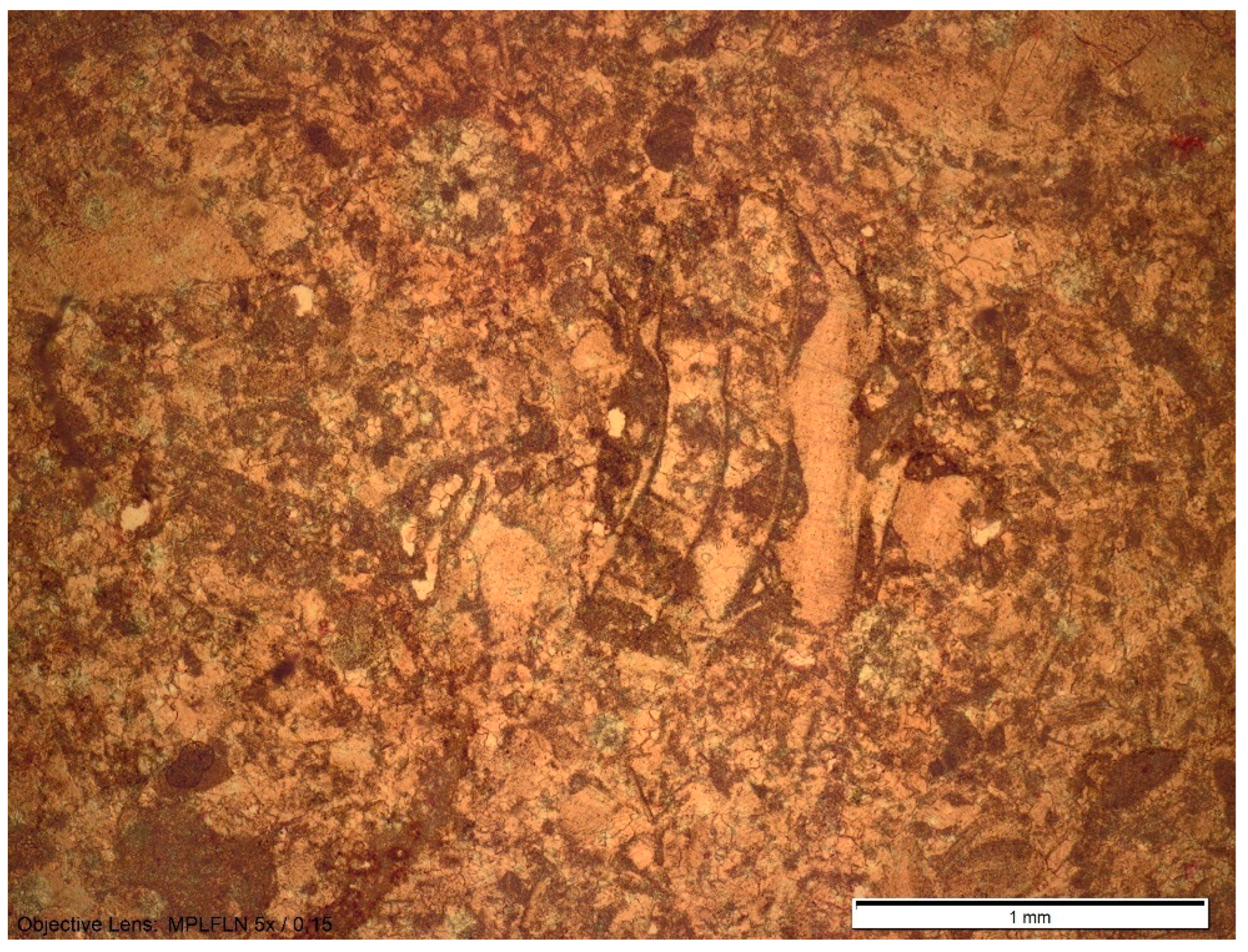
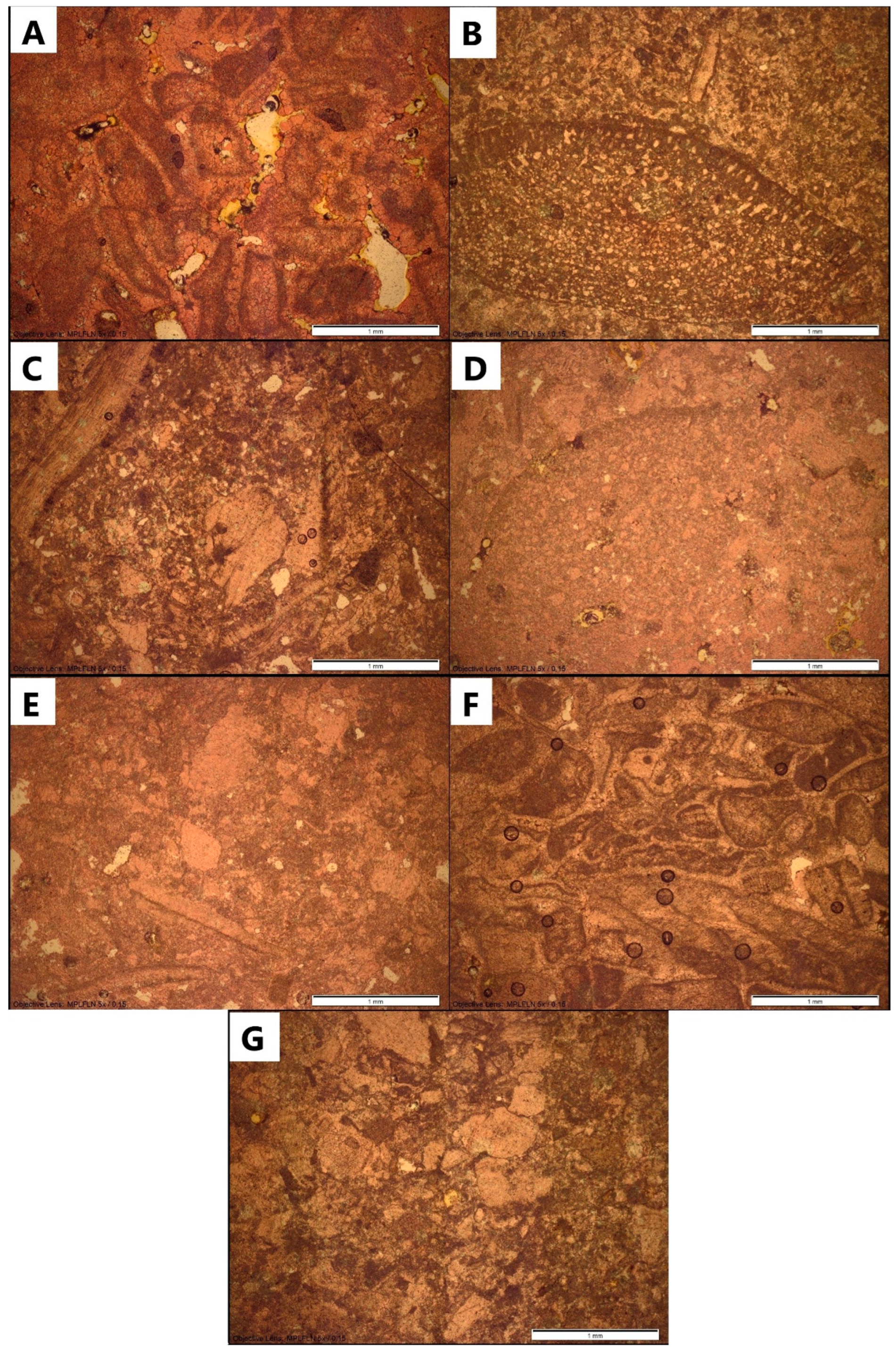
3. Micropetrographic Analysis of Archaeological Finds

3.1. Parentium Ager

Eight finds were sampled from the territory of the Parentium ager (Figure 2). One of the sites that we sampled is Monte Ricco, a villa rustica complex with a three-nave Roman cistern situated near the modern town of Vrsar (Orsera). The investigations started in 2014, and more recently indications of a metallurgical workshop have been discovered, while the remains of frescoes with vegetal and anthropomorphic motifs hint at the presence of a luxury complex. The finds of a large number of tubuli and tesserae also indicate the existence of a thermal complex [33,34]. The complex can be dated to around the middle of the 1st century BC, and it lasted at most until the end of the 1st century AD [33,34,35,36,37]. Four mosaic tesserae were selected for a micropetrographic analysis: two white and two dark grey (Figure 2B).
White tesserae were determined as packstone or a recrystallised biosparite to biomicrite with miliolids and echinoid spines and packstone or intramicrite with miliolids (Figure 3A,B). The presence of benthic foraminiferas (miliolids) and echinoid spines, as well as micrite matrix, point to shallow-water environments. Dark grey tesserae were determined as bioclastic packstone or biomicrite (biocalcarenite) (Figure 3C,D). Their dark grey colour points to deep-water sedimentation. No age-diagnostic microfossils are present, other than Pseudonummoloculina heimi (Bonet), which indicates the minimum age of the deposits from the middle Albian to the middle Campanian (personal communication Blanka Cvetko Tešović) [38,39].
In the lapidary of the Poreč Local Museum, samples were taken from three monument fragments—two epigraphic and one anepigraphic (S-5, S-6, S-7)—while one monument from the Parentium ager is kept in the Franciscan monastery in Pula (S-8). The hypothesised origin of the stone for the first two monuments (S-5 and S-6) was the Jurassic deposits of the Muča Formation due to their macroscopic similarity—they are white in colour and very brittle and easy to work on. These deposits were then sampled at the location of a Roman quarry at Biškupovi vrhi (Q-6), but a sample was also taken from the Roman quarry on the town beach in Poreč (Naftaplin) due to its proximity to the ancient city, even though, according to the geological map, these deposits are of a different age and lithology.
Sample S-5 is a large stone architrave block bearing part of a Latin funerary inscription (Figure 2C), see [40], EDR133257. The block dates to the 1st century CE. Sample S-5 was determined as a partially recrystallised bioclastic-oncoid wackestone or an oncoid biomicrite with dominant clasts of green algae. A certain porosity is noticeable in the sample. An important micropetrographic characteristic of this sample consists of a filamentous structure of the Upper Jurassic–Lower Cretaceous species Bacinella irregularis Radoičić (Figure 4) [41]. Bacinella irregularis was described as an alga incertae sedis due to the uncertainty of its phylogenetic position. However, some authors consider it a stromatoporoidea or a hydrozoan, such as Cladocoropsis Felix [41].
Sample S-6 represents the architrave of a temple with a frieze of plant tendrils decorated in low relief (Figure 2D). The fragment is dated between the 1st and 2nd centuries CE. The sample of this monument is more recrystallised than the previous one, and therefore, it is determined as algal oncosparite, with dominant clasts of green algae and the presence of peloids. Bacinella irregularis is also present (Figure 5A), forming the core of the oncoids, as well as Trocholina sp. Paalzow. The porosity of the sample is noticeable. Bacinella irregularis is characteristic for Aptian deposits in Istria, but it also appears in Jurassic deposits (Figure 5B) [41].
Sample S-7 was taken from a fragment of a stone block with part of a Latin funerary inscription for a certain Cladus dating to the 1st century CE (Figure 2E), see [40], EDR133193. The sample is a micritic limestone or mudstone with no microfossils or other characteristics that would help us determine its geological age (Figure 6).
Sample S-8 represents a stela of Calvia Marcella found in Maštelići near Vižinada dated from the second half of the 1st century BCE to the beginning of the 1st century CE (Figure 2A), see [40], EDR134380. The limestone is a bioclastic packstone or biomicrite with predominant rudist fragments and orbitolinid tests (Figure 7).

3.2. Ager Polensis

Seven profane and funerary monuments held at the Franciscan monastery in Pula from the ager polensis were sampled.
Sample S-9 was taken from the lid of a sarcophagus found in Šišan, carrying the remains of one Octavius Silonis (Figure 8A), see [40], EDR138835. It dates from the second half of the 1st century BCE to the beginning of the 1st century CE. The sample was identified as bioclastic grainstone with predominant micritised bioclasts (fragments of bivalves and spines of sea urchins) or a recrystallised biosparite (Figure 9A).
Sample S-10 comes from the cippus of C. Vibius Albanus (Figure 8B), see [40], EDR137613. This tombstone was found in Pula, and the sample was identified as floutstone, or a rudist biomicrudite with dominant rudist fragments (Figure 9B).
A fragment of the tombstone of Pollentia Clymena—sample S-11—was found in Pula at the end of the 19th century (Figure 8C). It dates to the end of the 1st century CE, see [40], EDR137267. The sample is a bioclastic packstone to floutstone, or a rudist biomicrite to biomicrudite. It contains rudist fragments and several specimens of orbitolinid tests (Figure 9C).
Sample S-12 was taken from a funerary monument of Maecenas Rufus (Figure 8D). The monument was found in the area of today’s Valmade settlement, near the road leading from Pula to Šišan, see [40], EDR071694. The sample was determined as a bioclastic packstone to floutstone, or rudist biomicrite to biomicrudite with predominant rudist fragments and orbitolinae (Figure 9D).
Sample S-13 represents the stela made by Vibia Arbuscula, a freedwoman (Figure 8E), see [40], EDR137683. She had it commissioned for herself and Gaius Vibius Felix, a man she herself set free. The monument was found in Pula in the second half of the 19th century and dates back to the 1st–2nd century CE. The sample was determined as a bioclastic wackestone to packstone, or a rudist biomicrite with predominant rudist fragments (Figure 9E).
Sample S-14 represents an architrave with an inscription and plant relief on the lower side (Figure 8F), see [40], EDR135646. It dates from the end of the 1st century BCE to the first half of the 1st century CE at the latest and was found in Carrara Street in Pula near the Double Gate at the beginning of the 20th century. The sample was determined as a bioclastic grainstone or biosparite with recrystallised and micritised bioclasts of rudists and other bivalves and urchin spines (Figure 9F).
Sample S-15 was taken from a stela of Anusia Tertia and Titus Sornatius dated from the second half of the 1st century BCE to the beginning of the 1st century CE (Figure 8G), see [40], EDR136447. It was found in Pula at the beginning of the second half of the 19th century. The sample was determined as a bioclastic packstone to floutstone, or a rudist biomicrite to biomicrudite with predominant rudist fragments and orbitolinae (Figure 9G).

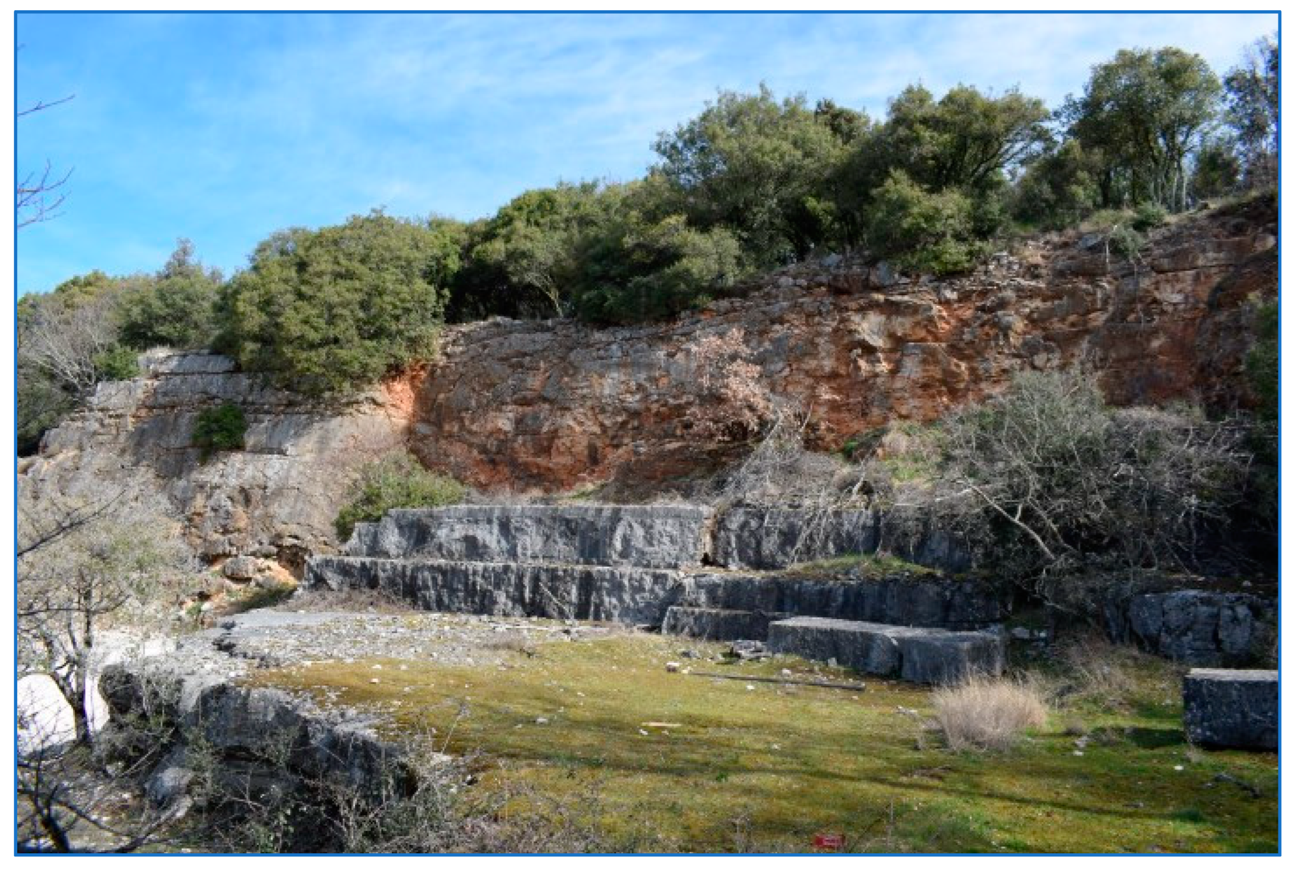
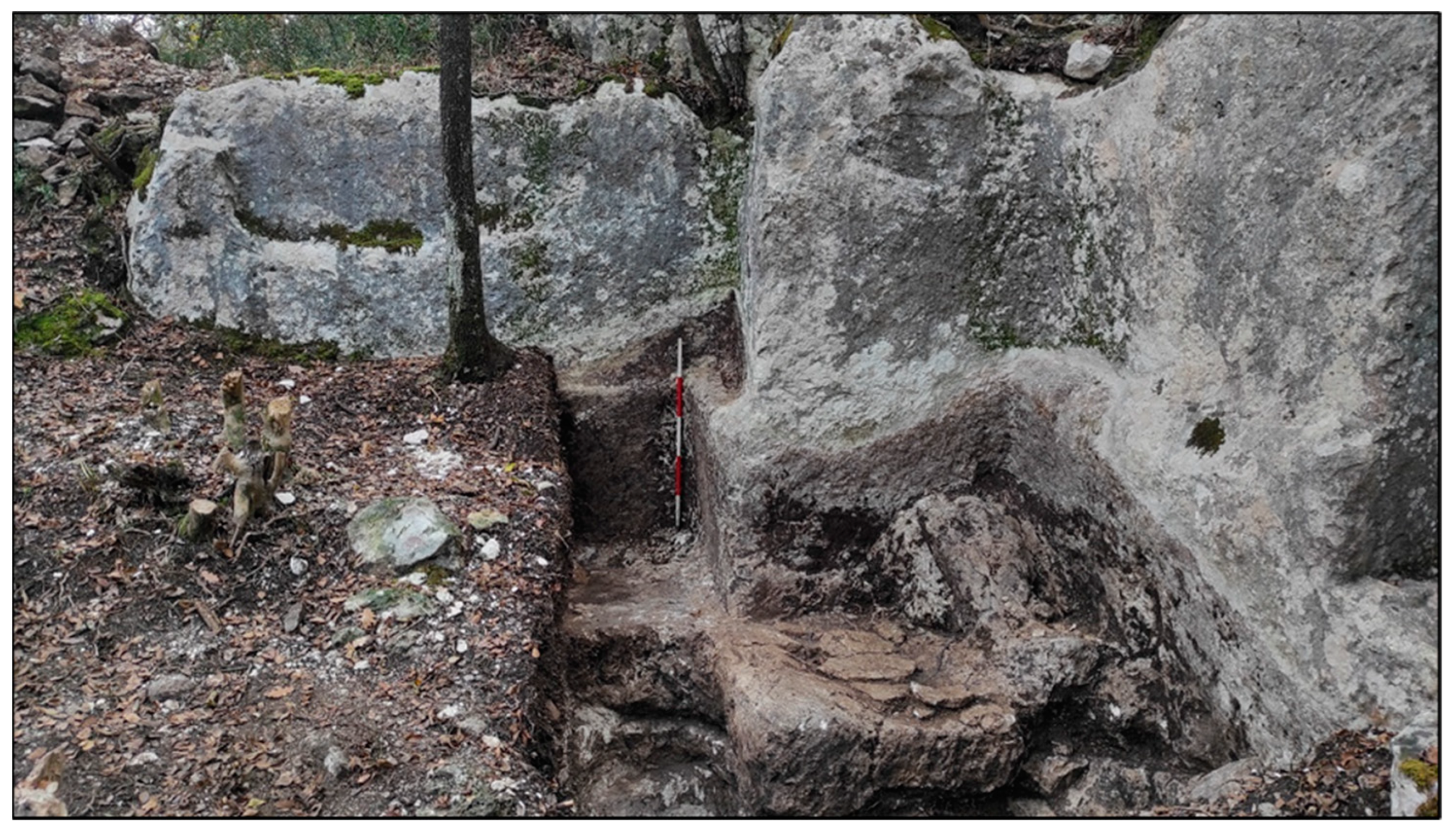
4. Sampled Roman Quarries

In the next part we will describe quarries, which are hypothesised to be potential sources of stone for the sampled monuments: Monte Ricco, Naftaplin, Monte del Vescovo, Pješčana Uvala, Cave Romane and Marčana.

4.1. Monte Ricco Quarry

On the southern side of the Monte Ricco hill is a quarry that is not used today and that shows no signs of Roman exploitation (Figure 10) [12]. However, on the hill itself, a Roman cistern and a villa rustica were excavated in the last 10 years [42], which leads us to conclude that the hill might have functioned as a source of stone for the rural estate. Other than Roman remains, fragments of prehistoric pottery were also found during the excavation of the site [36]. Today, the quarry is filled with rubble. The quarry exploited Upper Jurassic (Upper Tithonian) deposits called Kirmenjak, one of the most famous Istrian stones known for its hardness and endurance [43]. Two samples taken for micropetrographic analysis were determined as mudstone to grainstone, or pelsparite with peloids and Favreina microcoprolites (Q-1), and mudstone to packstone, or fenestral micrite (dismicrite) (Q-2) (Figure 11). Peloids and Favreina microcoprolites point to low intertidal, shallow subtidal or supratidal environments [44].

4.2. Poreč (Naftaplin) Quarry

In the modern town of Poreč, at the city beach (Naftaplin), a quarry was opened in antiquity based on Upper Jurassic (Oxfordian-Lower Kimmeridgian) deposits (Figure 12) [20]. Tool traces are still visible in some parts. The quarry was also used in later periods, especially during the Middle Ages [22]. A sample taken from the quarry was determined as a fenestral mudstone or dismicrite (Q-3; Figure 13).

4.3. Biškupovi Vrhi (Monte Del Vescovo) Quarry

A quarry with tool marks was documented and excavated at the locality of Biškupovi vrhi (Monte del Vescovo) near the modern town of Vrsar (Figure 14) [45]. The tool marks consist of striae made by a pick and channels for extracting stone blocks. Three measured channels have a width of 18 to 20 cm, which is comparable to channels in Roman quarries in the region of Dalmatia. The layout of the quarry is regular and squared, which also matches the layouts of known Roman quarries and their systematic exploitation of stone blocks [10].
In September and October 2020, the quarry was excavated as part of the ArchaeoCulTour project (Full name The Archaeological Landscape in a Sustainable Development of Cultural Tourism in the Municipality of Vrsar, HRZZ-PAR-2017-02-1: https://ffpu.unipu.hr/cirla/en/projects/archaeocultour, accessed on 28 November 2024), during which several roughly worked stone blocks were found [45]. The length, width and height of the extracted stone blocks can be estimated according to the channels in the quarry, as well as the exposed blocks at the bottom. The extracted stone blocks were 2 × 1 × 0.8 in length, width and height. We assume they were intended to be used as sarcophagi. The stone extracted here is soft and brittle, which makes it easier to process. The geological age of these deposits is Late Jurassic (Oxfordian–Lower Kimmeridgian) [46]. A sample was taken (Q-6) and determined, via micropetrographic analysis, to be a recrystallised ooid-bioclastic grainstone or oosparite to biosparite rich with bioclasts of Chablaisia chablaisensis (Septfontaine) (Figure 15) [45]. This lithotype is characteristic of environments of a tidal bar and predominant tidal influence [47].

4.4. Pješčana Uvala Quarry

During the construction of a house on a private plot in the fall of 2020, a Roman quarry was discovered in the settlement of Pješčana Uvala near Pula (Figure 16). It was investigated by Arheo TiM d.o.o. in the autumn of the same year. (I would like to thank Teodora Godinović Mikačić from Arheo TiM d.o.o. for allowing me to document and sample the quarry.) An unfinished sarcophagus was found in situ at the bottom of the quarry that was damaged probably during manufacture and subsequently left in the quarry. Another sarcophagus and a sarcophagus lid were found in the sediment. In December of the same year, the quarry was laser-scanned to obtain a precise layout, see [21], Figure 165. The dimensions of the quarry are approximately as follows: length 31 m; width, 23 m; height of one of its faces, 3.5 m. It can be roughly dated from the first to the fourth century AD (Personal communication, Teodora Godinović Mikačić). The quarry is located about 600 m southwest of the famous Cave Romane quarry in Vinkuran and lies on deposits of the same age. It is located closer to the coast than the aforementioned quarry, which makes the stone blocks extracted from this place easier to transport by sea to another location.
Petrographic samples were taken at two locations in the quarry. One sample was determined as a rudstone to floutstone or biomicrite to biosparudite (Q-7) and the other a floutstone or biomicrudite (Q-8), both with predominant rudist fragments and the sporadic appearance of orbitolinae (Figure 17).

4.5. Cave Romane (Vinkuran)

The most famous Roman quarry in the Istrian peninsula is the Cave Romane quarry near Vinkuran, south of Pula (Figure 18). Lower Cenomanian limestone extracted here was used for the outer shell of the Roman Amphitheatre in Pula [11,12]. To this day, it has preserved the name Cave Romane, probably due to its significance or an awareness among locals of its age. The quarry is located about 500 m from Veruda Bay, which, along with the slope of the terrain, facilitated land transport to the coast and then by sea to other destinations [13]. Tool marks can still be seen in the quarry, and a recent field survey documented a part of the quarry with traces of Roman exploitation high above the western cliff, which is hidden by dense vegetation. Channels documented in this quarry are 20 cm wide. Today, the quarry is used for concerts due to its excellent acoustics, while the cliff faces are used by climbers.
We took three samples; sample Q-9 was determined to be bioclastic floutstone or biomicrite, sample Q-10 was determined to be bioclastic packstone to floutstone or biomicrite to biomicrudite, while sample Q-11 was determined to be bioclastic floutstone or biomicrudite. Rudist fragments are dominant in all three samples, while orbitolinae appear less often (Figure 19).

4.6. Marčana

Between the towns of Marčana and Mutvoran, a large quarry is located (Figure 20). It was probably used in antiquity since the quarry faces preserve toolmarks and channels consistent with Roman-period extraction, while several stone monuments from Pula and Nesactium show structures similar to these deposits [12]. Limestone extracted here is of the Cenomanian age [20].
Two petrographic samples were taken from the quarry (Q-12 and Q-13). Both samples were determined to be grainstones or biosparites with predominant shell fragments (rudists) and urchin spines (Figure 21). This microfacies is typical for Wilson’s platform-edge and platform sand shoal facies belts strongly influenced by tidal currents [48].

5. Connectedness, Transport and Profitability Analysis

The transport of goods in Istria, including stone blocks from quarries to their end location, depended largely on the connectedness of the peninsula. Istria is surrounded by the sea on two sides, while in the north, it is bounded by the Ćićarija mountainous plateau, which can only be crossed in two or three places. Marshy valleys and rivers in the north also represent serious obstacles for the establishment of roads. The southern part of the Istrian peninsula is flatter and without rivers, which makes it easier for overland traffic [12]. The road network that was established after the pacification of the peninsula during the reign of Augustus followed the routes of prehistoric roads that connected the most important settlements before Antiquity [12,49]. Roads were established between military checkpoints for better control of the conquered area so that travel could be faster and safer. Along the coastal areas, roads were mostly used as an alternative to maritime traffic during winter when sailing was limited [49].
In antiquity, overland transport was generally much more expensive than maritime transport, as attested, for instance, by the so-called Price Edict of Diocletian. Russell has extrapolated ratios of the transport costs by sea, river downstream, river upstream and land, respectively, at 1:3.9:7.7:42 [50], which explains why the focus of Roman politics was on maritime transport [12]. The indented western coast of Istria was connected to the surrounding areas through maritime trade but also through piracy since prehistory [4]. It is rich in many sheltered bays that could have served as anchorages for ships, while later, they probably had an important economic role as various products were imported and exported through them. On the other hand, the eastern coast of Istria is steep, which makes it difficult for ships to anchor [12]. Navigation itself depended on weather and seasonal circumstances, as well as on economic and other needs. In particular, short-distance navigation along the coast was developed, and this type of navigation almost completely replaced overland transport. The main navigation route led between the larger islands and the mainland so that the vessels were protected from the open sea, yet close enough to a bay to be able to take shelter in it if necessary [49].
Since there are huge differences in cost between land and maritime transport, it is important to keep in mind the connection between the proximity of the source of stone and the possibility of transportation. Due to maritime transport being the cheapest, the quarries from which stone blocks were extracted were most often located near the mouth of the river or on the seashore [50]. That is also the case in Dalmatia, where a large number of roman quarries are located on islands [51] which facilitates transport. In the Istrian peninsula, most of the quarries were opened on the seashore, with the exception of the quarries in the Orsera municipality (Flengi and Delići-Kontija), Bale-Skačota and Pula-Šandalja. However, the stone extracted there could have been needed locally for many of the villae rusticae documented and researched in their vicinity [52], or if necessary, the stone could have been transported via roads, which were supposedly extended in the vicinity [53]. Nevertheless, the primary reason for opening a quarry still remains the quality of the stone itself.

6. Results and Discussion

We sampled fifteen (15) Roman monuments and sites for a comparative micropetrographic analysis. We divided them according to their ager affiliation and decided to compare their lithofacies to a quarry or an outcrop according to their closeness to Pola or Parentium.
Monte Ricco gave us an interesting example of the decorative use of limestone in the form of tesserae. The problem with these tesserae is the absence of age-diagnostic fossils, which could point to the specific age of the stone. According to their texture, composition and facies, the darker tesserae indicate deposition in a deep-water environment, like the Sveti Duh formation of Late Cenomanian–Early Turonian (Figure 22).
A micropetrographic and microfacies analysis based on Roman tesserae was also carried out by colleagues from Slovenia. A. Šmuc and co-authors conducted analyses on a total of 42 limestone tesserae from 15 different mosaics from archaeological sites in Ljubljana, Izola, Mošnje, Ptuj, Črnomelje and Šentpavel, with the aim of determining their origin [54]. They investigated white and black tesserae and determined several specific microfacies. According to the environment deposition, rock age and microfacies characteristics, they tried to find outcrops that would suit them. They were guided by the work of Flügel and Flügel who also performed research on tesserae from Roman sites and divided the source of origin into local (within ten kilometres), regional (within 40 km) and foreign or imported (further than 40 km) [55]. The geological age of the studied tesserae from Slovenia was determined at the level of the period (Jurassic, Cretaceous), epochs (Upper or Lower Cretaceous) or age (Cenomanian, Turonian, etc.), and based on that, the researchers suggested ancient quarries that could have been the source for the studied tesserae. Their analysis suggested that all tesserae were brought to these sites from much further away since they were regional or imported; their origin lies outside the radius of ten kilometres [54].
Two monuments from the Poreč Local Museum, sampled under S-5 and S-6, had macroscopic similarities to Upper Jurassic Muča deposits. These deposits outcrop in the north and south of the Lim channel, and at least a dozen quarries with tool marks were documented [21]. One of them is Monte del Vescovo (Biškupovi vrhi) (Figure 23). We investigated it and took samples [45]. The rock from the quarry was determined as a recrystallised ooid-bioclastic grainstone, i.e., biosparite to oosparite. Any one of the documented quarries opened on these deposits could have been the source for the two monuments, since they are all located close to the presumed heading of a Roman road [53]. We also took a sample from a quarry closer to the city of Poreč (Naftaplin), which we determined to be a fenestral mudstone or dismicrite. What makes the Parentium monuments S-5 and S-6 and the Jurassic deposits of the Muča formation similar is the presence of Bacinella irregularis, as well as the general similarity in microfacies.
Our third sample from the Parentium ager, S-7, a stone block with a funerary inscription, showed us the limitations of the micropetrographic analysis discussed by Šprem and Barudžija [56]. When the sample does not contain characteristic microfossils, the age of the sample cannot be determined.
The funerary monument S-8 is made from a limestone characteristic of the Rušnjak formation of the Upper Cretaceous, with the most famous extraction point being the Cave Romane quarry near Vinkuran, south of Pula. But considering the place where this monument was found (just north of the Mirna valley in north-western Istria), it is unlikely that the stone for its manufacture was brought from the south of Istria. Moreover, deposits of the same age can also be found on the northern bank of the Mirna River extracted in the St. Stjepan quarry, closed off 60 years ago (Figure 24) [57]. Given the fact that the Mirna River was navigable in ancient times as far as Motovun [58], it was easy to transport the stone to desired locations by river. It is possible that St. Stjepan’s quarry was active during Roman administration of the peninsula, and the stone for the stela of Calvia Marcella might have come from there. However, we have not yet sampled the quarry, so this remains only a hypothesis.
Most of the funerary monuments from the Pula area—S-10, S-11, S-12, S-13 and S-15—are made of Cenomanian limestone like the one exploited in the Vinkuran quarry. But Cenomanian limestone was also extracted from the newly discovered quarry in Pješčana Uvala, and it is very difficult to distinguish between the two lithotypes. The Pješčana Uvala quarry is located closer to the coast; therefore, the stone blocks were easier to transport via boat. Two monuments from the area of Pula—S-10 and S-14—are distinguished by a lithotype that was exploited in the Marčana quarry, further away than Pješčana Uvala or Vinkuran quarry. This could indicate that people sought this stone rather than the one closer to Pola, for some reason. We must certainly mention that there is a possibility the same lithotype may have been extracted in as yet undiscovered quarries closer to Pula, for example, the Pećine quarry near Ližnjan which we have not yet sampled, but which was mentioned and described by Tišljar [44].

7. Conclusions

The Istrian peninsula is rich in carbonate surface deposits of the Jurassic, Cretaceous and Paleogene Age. They were exploited for construction and funerary purposes since later prehistory and usually extracted in the immediate vicinity of the settlement. With the arrival of the Roman administration, the exploitation of limestone became systematic, as evidenced by the rectangular layouts of the quarries, which were the result of extracting regular blocks using the channelling technique. The quarries were also mostly situated near the sea due to lower cost of maritime transport.
We sampled fifteen (15) monuments from the Parentium ager and ager polensis, both funerary and profane. Funerary monuments and temple fragments were mostly made from local stone, but not always. The sarcophagus of Octavius Silonis from Šišan (S-9) and architrave fragment with plant relief (S-14) from ager polensis showed us that the closest source was not always the first choice. Their proposed origin is the quarry in Marčana, which means that it must have been opened very early after the foundation of Pola in 45 BCE. Other funerary monuments from the ager polensis—S-10, S-11, S-12, S-13 and S-15—were made from Cenomanian limestone, like the one exploited in Vinkuran and Pješčana Uvala. Both quarries have similar lithotypes, meaning they are mostly indistinguishable. It is to be hoped that different approaches might eventually be able to discriminate between these quarry sources. It is important to point out the vicinity of both the Vinkuran and Pješčana Uvala quarries to the Soline Bay, which facilitated the transport of extracted stone blocks.
An architrave with a Latin funerary inscription (S-5) and an architrave with plant tendrils in low relief (S-6) from the area of Parentium are made of limestone of a Late Jurassic age. It is brittle, which makes it easier to work on. Deposits of a similar age are dispersed throughout the ager, and at least a dozen quarries with tool marks were documented. The lithotype of the sample was similar to the one we took from Monte del Vescovo quarry, which shows that this white and brittle limestone was sought after during the Roman administration.
A stone block with a Latin funerary inscription (S-7) from Parentium showed no characteristic microfossils or other details that might point us in the direction of its source. This is one limitation of the micropetrographic analysis—other than several quarries having similar lithotypes, samples can also be void of any defining characteristic. The case with tesserae from Monte Ricco showed us the other limitation. Samples can be too small for us to be able to detect age-diagnostic fossils; therefore, we can only interpret the sedimentation environment like we did with the darker tesserae.
Even though micropetrographic analysis cannot answer the question of the provenance of stone itself, it is nevertheless a first step in the right direction. Since Istrian geology is very specific, with surface deposits mostly of a Jurassic and Cretaceous Age and with Roman quarries opened mostly depending on transport possibilities, we suggested some considerations on stone exploitation. We are also aware that not all places of Roman exploitation are yet discovered. This research is developmental in nature and will be continued in years to come. Geochemical and stable isotope analyses will be needed to answer the questions of provenance in more detail.

Funding

This research was funded by the Croatian Science Foundation, grant number ESF-DOK-01-2018, and Croatian Science Foundation, Vrsar Municipality, Vrsar Tourist Board and Maistra d.d., grant number HRZZ-PAR-2017-02-1.

Data Availability Statement

The raw data supporting the conclusions of this article will be made available by the authors on request.

Acknowledgments

The data presented in this paper are the result of the author’s doctoral research, for which the assistant position at the Faculty of Humanities was financed by the Croatian Science Foundation through the project Young Researchers’ Career Development (ESF-DOK-01-2018). Postgraduate tuition was financed by the project ArchaeoCulTour—Archaeological landscape in a sustainable to the development of cultural tourism in the Municipality of Vrsar (HRZZ-PAR-2017-02-1), financed by the Croatian Science Foundation, Municipality of Vrsar, Tourist Board of Municipality of Vrsar and Maistra d.d., for which I sincerely thank my mentor and project manager Robert Matijašić. The doctoral research was also partly financed by the ArchaeoCulTour project and partly by the author herself. I owe a debt of gratitude to Darko Komšo, director of the Archaeological Museum of Istria in Pula, Croatia, and Gaetano Benčić from the Museum of Poreč territory, for their approval of the sampling of the Roman monuments. For their help with the micropetrographic analysis I would like to thank Uroš Barudžija, Blanka Cvetko Tešović and Vlasta Ćosović. I would also like to thank Ener and Vedrana Špada from METRIS—Research Centre for Materials of the Istrian University of Applied Sciences, for their help with the photomicrographs, and Dan P. Diffendale for his helpful comments on this paper. The author is grateful to the three anonymous reviewers who contributed to improve this paper through comments and suggestions.

Conflicts of Interest

The author declares no conflict of interest.

References

  1. Vlahović, I.; Velić, I.; Dubravko, M. A brief introduction to the geology of Istria. In Proceedings of the 7th Croatian Geological Congress with International Participation Excursion Guide-Book, Poreč, Croatia, 2–4 October 2023; Fio Firi, K., Čobić, A., Eds.; Hrvatski Geološki Institut: Poreč, Croatia, 2023; pp. 1–13. [Google Scholar]
  2. Vlahović, I.; Tišljar, J.; Velić, I.; Dubravko, M. Evolution of the Adriatic Carbonate Platform: Paleogeography, main events and depositional dynamics. Palaeogeogr. Palaeoclimatol. Palaeoecol. 2005, 220, 333–360. [Google Scholar] [CrossRef]
  3. Tišljar, J. Sedimentologija Karbonata i Evaporita; Institut za Geološka Istraživanja: Zagreb, Croatia, 2001. [Google Scholar]
  4. Gabrovec, S.; Mihovilić, K. Istarska grupa. In Praistorija Jugoslavenskih Zemalja V; Gabrovec, S., Ed.; Akademija Nauka i Umjetnosti Bosne i Hercegovine: Sarajevo, Bosnia and Herzegovina, 1987; pp. 293–338. [Google Scholar]
  5. Codacci-Terlević, G. Prilog poznavanju brončanodobnih pogrebnih običaja u Istri–Stanje istraženosti istarskih tumula te rezultati istraživanja tumula iz uvale Marić kod Barbarige. Histria Archaeol. 2004, 35, 41–74. [Google Scholar]
  6. Hänsel, B.; Kristina, M.; Monkodonja, B.T. Utvrđeno protourbano naselje starijeg i srednjeg brončanog doba kod Rovinja u Istri. Histria Archaeol. 1997, 28, 37–107. [Google Scholar]
  7. Buršić-Matijašić, K. Gradinska Naselja. Gradine Istre u Vremenu i Prostoru; Leykam International: Zagreb, Croatia, 2008. [Google Scholar]
  8. Hänsel, B.; Mihovilić, K.; Biba, T. Monkodonja. Istraživanje Protourbanog Naselja Brončanog Doba Istre. Knjiga 1. Iskopavanje i Nalazi Građevina; Monografije i Katalozi 25, Arheološki muzej Istre: Pula, Croatia, 2015. [Google Scholar]
  9. Matijašić, R. Romanizaton of the Histri in the Early Roman Period. In Illyrica Antiqua in Honorem Duje Rendić-Miočević, Proceedings of the Internatonal Conference, Šibenik, 12–15 September 2013; Demicheli, D., Ed.; Department of Archaeology, Faculty of Humanities and Social Sciences, University of Zagreb: Zagreb, Croatia, 2017; pp. 379–390. [Google Scholar]
  10. Parica, M. Arheološki Tragovi Kamenarstva u Dalmaciji od Prapovijesti do Kraja Srednjeg Vijeka (Archaeological Evidence of Stone Quarrying in Dalmatia from Prehistory to the End of the Middle Ages). Ph.D. Thesis, University of Zagreb, Zagreb, Croatia, 2014. (Summary in English). [Google Scholar]
  11. Crnković, B. The Origin of the Dimension Stone of the Arena in Pula. Rud.-Geološko-Naft. Zb. 1991, 3, 63–67. [Google Scholar]
  12. Matijašić, R. Gospodarstvo antičke Istre; Zavičajna Naklada “Žakan Juri” Pula: Pula, Croatia, 1998. [Google Scholar]
  13. Šonje, A. Iz kojeg istarskog kamena potječe kupola Teodorikova mauzoleja u Ravenni. In Materijali, Tehnike i Strukture; Suić, M., Zaninović, M., Eds.; Odjel za Arheologiju, Centar za Povijesne Znanosti: Zagreb, Croatia, 1980; pp. 149–160. [Google Scholar]
  14. Pleničar, M.; Polšak, A.; Dragutin, Š. Osnovna Geološka Karta SFRJ M 1:100 000, List Trst L 33-88; Geološki Zavod Ljubljana: Ljubljana, Slovenia; Inštitut za Geološka Istraživanja Zagreb: Zagreb, Croatia; Savezni Geološki Institut Beograd: Beograd, Serbia, 1969. [Google Scholar]
  15. Šikić, D.; Polšak, A.; Nikola, M. Osnovna Geološka Karta SFRJ M 1:100 000, List Labin L 33-101; Inštitut za Geološka Istraživanja Zagreb: Zagreb, Croatia; Savezni Geološki Institut Beograd: Beograd, Serbia, 1969. [Google Scholar]
  16. Šikić, D.; Pleničar, M.; Marko, Š. Osnovna Geološka Karta SFRJ M 1:100 000, List Ilirska Bistrica L 33-89; Inštitut za Geološka Istraživanja Zagreb: Zagreb, Croatia; Savezni Geološki Institut Beograd: Beograd, Serbia, 1972. [Google Scholar]
  17. Polšak, A.; Dragutin, Š. Osnovna Geološka Karta SFRJ M 1:100 000, List Rovinj L 33-100; Inštitut za Geološka Istraživanja Zagreb: Zagreb, Croatia; Savezni Geološki Institut Beograd: Beograd, Serbia, 1969. [Google Scholar]
  18. Polšak, A. Osnovna Geološka Karta SFRJ M 1:100 000, List Pula L 33-112; Inštitut za Geološka Istraživanja Zagreb: Zagreb, Croatia; Savezni Geološki Institut Beograd: Beograd, Serbia, 1967. [Google Scholar]
  19. Magaš, N. Osnovna Geološka Karta SFRJ M 1:100 000, List Cres L 33-113; Institut za Geološka Istraživanja Zagreb: Zagreb, Croatia; Savezni Geološki Zavod Beograd: Beograd, Serbia, 1968. [Google Scholar]
  20. Miko, S.; Kruk, B.; Dedić, Ž.; Kruk, L.; Peh, Z.; Kovačević-Galović, E.; Anto, G. Rudarsko-Geološka Studija Potencijala i Gospodarenja Mineralnim Sirovinama Istarske Županije; Hrvatski Geološki Institute: Zagreb, Croatia, 2013. [Google Scholar]
  21. Šprem, K. Eksploatacija Kamene Sirovine u Prapovijesti i Antici Istarskoga Poluotoka (Exploitation of Stone Raw Material in Prehistory and Antiquity in the Istrian Peninsula). Ph.D. Thesis, University of Zagreb, Zagreb, Croatia, 30 September 2022. (Summary in English). [Google Scholar]
  22. Benčić, G. Note sulla lavorazione ed esportazione della pietra d’Istria nel medioevo. In Artisani et Mercatores: Artisans and merchants in the Adriatic Sea; Crljenko, M.M., Uljančić, E., Eds.; Državni Arhiv u Pazinu: Pazin, Croatia; Zavičajni Muzej Poreštine: Poreč, Croatia; Sveučilište Jurja Dobrile u Puli: Pula, Croatia, 2019; pp. 100–117. [Google Scholar]
  23. Paić, A. Sondažno arheološko istraživanje na lokalitetima Monmaggior i Mon dei Arni u sklopu TZ Valalta u Rovinju. 2024. [Google Scholar]
  24. Mlakar, Š. Amfiteatar u Puli; Arheološki muzej Istre u Puli: Pula, Croatia, 1996. [Google Scholar]
  25. Buršić-Matijašić, K.; Robert, M. The Extraction and Use of Limestone in Istria in Antiquity. In ASMOSIA XI Proceedings of the XI ASMOSIA Conference; Matetić Poljak, D., Marasović, K., Eds.; University of Split, Arts Academy in Split: Split, Croatia, 2018; pp. 925–931. [Google Scholar]
  26. Girardi-Jurkić, V. Korištenje kamena u gradnji amfiteatra u Puli. Histria Antiq. 1997, 3, 21–28. [Google Scholar]
  27. Zlatunić, R. Povijest i razvoj tehnologije vađenja kamena i kamenoklesarstva. In Tragovima Kamenoklesara; Starac, A., Ed.; Arheološki Muzej Istre u Puli: Pula, Croatia, 2006; pp. 185–206. [Google Scholar]
  28. Premužić Ančić, M.; Sanja, G. Quarries on the island Veliki Brijun, The Beginnings of their rehabilitation and adaptive reuse in Croatia. A Sch. J. Archit. Urban Plan. 2017, 25, 74–85. [Google Scholar]
  29. Girardi-Jurkić, V. The Cavae Romanae quarry. Properties and use of the stone for the amphitheatre in Pula. In Interdisciplinary Studies on Ancient Stone. Proceedings of the IX ASMOSIA Conference; Garcia-M., A.G., Mercadal, P.L., de Llanza, I.R., Eds.; Institut Català d’Arqueologia Clàssica: Tarragona, Spain, 2012; pp. 640–644. [Google Scholar]
  30. Dunham, R.J. Classification of carbonate rocks according to depositional texture. In Classification of Carbonate Rocks, AAPG Memoir 1; Ham, W.E., Ed.; American Association of Petroleum Geologists: Tulsa, OK, USA, 1962; pp. 108–121. [Google Scholar]
  31. Embry, A.F.; Edward Klovan, J. A late Devonian Reef tract on Northeastern Banks Island, N.W.T. Bull. Can. Pet. Geol. 1971, 19, 730–781. [Google Scholar]
  32. Folk, R.L. Spectral Subdivision of limestone types. In Classification of Carbonate Rocks, AAPG Memoir 1; Ham, W.E., Ed.; American Association of Petroleum Geologists: Tulsa, OK, USA, 1962; pp. 62–84. [Google Scholar]
  33. Bulić, D. Izvješće o Arheološkom Istraživanju na Lokalitetu Monte Ricco Kraj Vrsara u Lipnju 2020; Godine: Boston, MA, USA, 2020. [Google Scholar]
  34. Bulić, D. Izvješće o Arheološkom Istraživanju na Lokalitetu Monte Ricco Kraj Vrsara 2020; Godine: Boston, MA, USA, 2020. [Google Scholar]
  35. Bulić, D. Izvješće Arheološkog Istraživanja Antičke Cisterne na Lokalitetu Monte Ricco 2018; Godine: Boston, MA, USA, 2018. [Google Scholar]
  36. Bulić, D. Izvješće o Arheološkom Istraživanju na Lokalitetu Monte Ricco Kraj Vrsara 2019; Godine: Boston, MA, USA, 2019. [Google Scholar]
  37. Buršić-Matijašić, K.; Matijašić, R. Projekt RAT-ROPH i arheološko istraživanje u Vrsaru 2014. i 2015. Godine. Obavijesti Hrvat. Arheol. Društva God 2016, XLVIII, 17–26. [Google Scholar]
  38. Cvetko Tešović, B.; Glumac, B.; Damir, B. Integrated biostratigraphy and carbon isotope stratigraphy of the Lower Cretaceous (Barremian to Albian) Adriatic-Dinaridic carbonate platform deposits in Istria, Croatia. Cretac. Res. 2011, 32, 301–324. [Google Scholar] [CrossRef]
  39. Velić, I. Stratigraphy and Palaebiogeography of Mesozoic Benthic Foraminifera of the Karst Dinarides (SE Europe). Geol. Croat. 2007, 60, 1–113. [Google Scholar] [CrossRef]
  40. Epigraphic Database Roma. Available online: http://www.edr-edr.it/default/index.php (accessed on 24 November 2024).
  41. Schlagintweit, F.; Bover-Arnal, T.; Ramon, S. New insights into Lithocodium aggregatum Elliott (1956) and Bacinella irregularis Radoičić (1959) (Late Jurassic–Lower Cretaceous): Two ulvophycean green algae (? Order Ulotrichales) with a heteromorphic life cycle (epilithic/euendolithic). Facies 2010, 56, 509–547. [Google Scholar] [CrossRef]
  42. Buršić-Matijašić, K. (Ed.) Monte Ricco Kraj Vrsara. Rimskodobne Preobrazbe I Ponovna Uporaba Prapovijesnih Gradina Istre; CIRLA Monografije, Svezak 1, Sveučilište Jurja Dobrile u Puli i Općina Vrsar: Pula, Croatia, 2020. [Google Scholar]
  43. Cotman, I. Istraživanje arhitektonsko-građevnog kamen. In Kamen Pazin 1954–2004; Josip, B., Ivan, C., Eds.; “KAMEN” d. d.: Pazin, Croatia, 2004; pp. 80–101. [Google Scholar]
  44. Tišljar, J. Sedimentne Stijene; Školska Knjiga: Zagreb, Croatia, 1994. [Google Scholar]
  45. Šprem, K. What to expect when you’re documenting and excavating a Roman quarry–Monte del Vescovo, Istria, Croatia. In From Quarries to Rock-Cut Sites. Echoes of Stone Crafting; Anais, L., Katy, W., Gabriele, G., Claudia, S., Marie-Elise, P., Eds.; Sidestone Press: Leiden, The Netherlands, 2023; pp. 45–62. [Google Scholar]
  46. Matičec, D.; Velić, I.; Tišljar, J.; Vlahović, I.; Marinčić, S.; Ladislav, F. Osnovna Geološka Karta Republike Hrvatske M 1:50 000, List Rovinj 3 (572/3); Zavod za geologiju, 1 list; Hrvatski Geološki Institute: Zagreb, Croatia, 2015; ISBN 978-953-6907-26-7. [Google Scholar]
  47. Velić, I.; Matičec, D.; Vlahović, I.; Josip, T. Statigrafski slijed jurskih i donjokrednih karbonata (bat-gornji alb) u zapadnoj Istri (ekskurzija A). In First Croatian Geological Congress. Excursion Guide-Book; Igor, V., Ivo, V., Eds.; Institute of Geology and Croatian Geological Society: Zagreb, Croatia, 1995; pp. 30–66. [Google Scholar]
  48. Flügel, E. Microfacies of Carbonate Rocks. Analysis, Interpretation and Application; Springer: Berlin/Heidelberg, Germany, 2010. [Google Scholar]
  49. Matijašić, R. Povijest Hrvatskih Zemalja u Antici do Cara Dioklecijana; Leykam International: Zagreb, Croatia, 2009. [Google Scholar]
  50. Russell, B. The Economics of the Roman Stone Trade; Oxford University Press: Oxford, UK, 2014. [Google Scholar]
  51. Parica, M. Nekoliko primjera lučkih instalacija antičkih kamenoloma na dalmatinskim otocima. Histria Antiq. 2012, 21, 345–354. [Google Scholar]
  52. Bulić, D. Rimska Ruralna Arhitektura Istre u Kontekstu Ekonomske i Socijalne Povijesti. Ph.D. Thesis, University of Zadar, Zadar, Croatia, 9 January 2015. (Summary in English). [Google Scholar]
  53. Šprem, K. All aboard! Quarries and transport in Roman Istria. In Proceedings from the 7th Scientific Conference Methodology and Archaeometry; Ina, M., Ed.; University of Zagreb Faculty of Humanities and Social Sciences: Zagreb, Croatia, 2021; pp. 67–85. [Google Scholar]
  54. Šmuc, A.; Dolenec, M.; Lesar-Kikelj, M.; Lux, J.; Pflaum, M.; Šeme, B.; Županek, B.; Gale, L.; Sabina, K. Variety of black and white limestone tesserae used in Ancient Mosaics in Slovenia. Archaeometry 2016, 59, 205–221. [Google Scholar] [CrossRef]
  55. Flügel, E.; Christof, F. Applied Microfacies Analysis: Provenance Studies of Roman Mosaic Stones. Facies 1997, 37, 1–48. [Google Scholar] [CrossRef]
  56. Šprem, K.; Uroš, B. Micropetrographic analysis as a tool for the determination of limestone sources in Istria–applications and limitations. In Proceedings from the 8th and 9th Scientific Conference Methodology and Archaeometry; Ina, M., Ed.; University of Zagreb Faculty of Humanities and Social Sciences: Zagreb, Croatia, 2022; pp. 121–128. [Google Scholar]
  57. Cotman, I. Probna podzemna eksploatacija arhitektonsko-građevnog kamena u kamenolomu “Kanfanar“, Istra. Rud.-Geološko-Naft. Zb. 1996, 8, 81–89. [Google Scholar]
  58. Milotić, I. Dolina Mirne u Antici; Ekološki Glasnik: Zagreb, Croatia, 2004. [Google Scholar]
  59. Bergant, S.; Matičec, D.; Fuček, L.; Palenik, D.; Korbar, T.; Šparica, M.; Koch, G.; Ivan, G. Osnovna Geološka Karta Republike Hrvatske M 1:50 000, List Rovinj 2 (366/2); Zavod za geologiju, 1 list; Hrvatski Geološki Institut: Zagreb, Croatia, 2020; ISBN 978-953-6907-75-5. [Google Scholar]
Figure 2. Sampled finds and monuments from the territory of Parentium. (A) Stela of Calvia Marcela (S-8), (B) white and dark grey limestone tesserae from Monte Ricco (S-1 to S-4), (C) stone architrave with an inscription (S-5), (D) architrave with a frieze (S-6) and (E) stone block with an inscription (S-7).
Minerals 14 01233 g002
Figure 3. Photomicrographs of white (A,B) and dark grey tesserae (C,D) from Monte Ricco, magnification 50×, PPL, gauge length 1 mm.
Minerals 14 01233 g003
Figure 4. Photomicrographs of Bacinella irregularis in sample S-5. Magnification 50×, PPL, gauge length 1 mm.
Minerals 14 01233 g004
Figure 5. The filamentous structure of Bacinella irregularis in sample S-6 (A) and sample Q-6 from Biškupovi vrhi (B). PPL, gauge length 1 mm.
Minerals 14 01233 g005
Figure 6. Photomicrograph of a sample taken from a stone beam (S-7), magnification 50×, PPL, gauge length 1 mm.
Minerals 14 01233 g006
Figure 7. Photomicrograph of sample S-8. Rudist fragments can be seen throughout, magnification 50×, PPL, gauge length 1 mm.
Minerals 14 01233 g007
Figure 8. Sampled funerary and profane monuments from the ager polensis. (A) S-9, (B) S-10, (C) S-11, (D) S-12, (E) S-13, (F) S-14, (G) S-15.
Minerals 14 01233 g008
Figure 9. Photomicrographs of samples taken from funerary and profane monuments held at the Franciscan monastery in Pula, Croatia, magnification 40×, PPL. (A) S-9, (B) S-10, (C) S-11, (D) S-12, (E) S-13, (F) S-14, (G) S-15.
Minerals 14 01233 g009
Figure 10. Monte Ricco quarry before backfilling (photo: Jan Sonnemans).
Minerals 14 01233 g010
Figure 11. Photomicrographs of samples from the Monte Ricco quarry, magnification 50×, PPL, gauge length 1 mm. (A) Sample from the high cliff, (B) sample from the bottom of the cliff face.
Minerals 14 01233 g011
Figure 12. Roman quarry at Poreč city beach (Naftaplin).
Minerals 14 01233 g012
Figure 13. Photomicrograph of a sample from Naftaplin quarry, magnification 50×, PPL, gauge length 1 mm.
Minerals 14 01233 g013
Figure 14. Monte del Vescovo Roman quarry with the bottoms of the channels visible, which gives us an idea of the height of the extracted stone blocks.
Minerals 14 01233 g014
Figure 15. Photomicrograph of the Monte del Vescovo quarry sample, magnification 50×, PPL, gauge length 1 mm. An oncoid with a Bacinella irregularis core can be seen on the left side of the photomicrograph.
Minerals 14 01233 g015
Figure 16. Pješčana Uvala Roman quarry. A sarcophagus can be seen in the middle right of the photo.
Minerals 14 01233 g016
Figure 17. Photomicrographs of samples from the Pješčana Uvala Roman quarry, magnification 50×, PPL, gauge length 1 mm. (A) Q-7. Rudist fragments can be seen dispersed in the sample. (B) Q-8. An orbitolinid test surrounded by rudist fragments.
Minerals 14 01233 g017
Figure 18. Cave Romane quarry, Vinkuran. (a) Entrance to the quarry, (b) tool traces seen on the quarry face, length of the wooden meter two meters.
Minerals 14 01233 g018
Figure 19. Photomicrographs of samples taken from the Cave Romane Roman quarry near Vinkuran, magnification 50×, PPL, gauge length 1 mm. Orbitolinid tests and rudist fragments characteristic of Cenomanian are predominant. (A) Q-10, (B) Q-11, (C) Q-12.
Minerals 14 01233 g019
Figure 20. Marčana quarry. (a) Quarry face with tool marks, (b) channel with a width of 20 cm.
Minerals 14 01233 g020
Figure 21. Photomicrographs of samples taken from the Marčana quarry, magnification 50×, PPL, gauge length 1 mm. Cortoids are dominant in both samples, along with a certain amount of porosity. (A) Q-12, (B) Q-13.
Minerals 14 01233 g021
Figure 22. Sveti Duh formation and Roman quarries in the Istrian peninsula.
Minerals 14 01233 g022
Figure 23. Geologic map of a part of the Parentium ager. Limestone of Muča formation (MU) can be seen throughout the map, and the Biškupovi vrhi quarry can be seen on the lower half of the figure (The geological map follows [46]).
Minerals 14 01233 g023
Figure 24. Geologic map of the eastern part of the Mirna valley. The Sv. Stjepan quarry can be seen in the upper right, while the site is on the lower left (The geological map follows [59]).
Minerals 14 01233 g024
Table 2. Samples from archaeological contexts taken for micropetrographic analysis.
SiteAgerNo of SampleType of Sample
Monte RiccoParentiumS-1white tessera
ParentiumS-2white tessera
ParentiumS-3black tessera
ParentiumS-4black tessera
PorečParentiumS-5stone beam
ParentiumS-6temple trabeation
ParentiumS-7stone beam
MaštelićiParentiumS-8funerary monument
PulaPolaS-9sarcophagus lid
PolaS-10cippus
PolaS-11funerary monument
PolaS-12funerary monument
PolaS-13funerary monument
PolaS-14architrave
PolaS-15funerary monument
Table 3. Samples from presumed Roman quarries taken for micropetrographic analysis.
QuarryAgerNo of SampleNo on the Map
Monte RiccoParentiumQ-110
ParentiumQ-2
PorečParentiumQ-55
Biškupovi vrhiParentiumQ-611
Pješčana UvalaPolaQ-737
PolaQ-8
Cave RomanePolaQ-938
PolaQ-10
PolaQ-11
MarčanaPolaQ-1230
PolaQ-13
Disclaimer/Publisher’s Note: The statements, opinions and data contained in all publications are solely those of the individual author(s) and contributor(s) and not of MDPI and/or the editor(s). MDPI and/or the editor(s) disclaim responsibility for any injury to people or property resulting from any ideas, methods, instructions or products referred to in the content.

