Article

Unconformities and Gold in New Zealand: Potential Analogues for the Archean Witwatersrand of South Africa

1
Geology Department, University of Otago, Dunedin 9010, New Zealand
2
School of Geography, Earth and Atmospheric Sciences, University of Melbourne, Melbourne 3145, Australia
3
Department of Earth Sciences, Stellenbosch University, Stellenbosch 7602, South Africa
4
Effective Investments Pty Ltd., South Perth 6951, Australia
*
Author to whom correspondence should be addressed.
Minerals 2023, 13(8), 1041; https://doi.org/10.3390/min13081041
Submission received: 19 June 2023 / Revised: 30 July 2023 / Accepted: 2 August 2023 / Published: 4 August 2023

Abstract

:
Possible young analogues for regionally extensive unconformities (100 to 400 km2) in the gold-bearing Witwatersrand Supergroup (Archean, South Africa) occur in the South Island of New Zealand. Extensive marine unconformities in New Zealand show progression from an unconformity surface to conglomerate to clean well-sorted sandstone to marine mudstone, as is also found in the major Witwatersrand auriferous reef horizons. The hosting young sedimentary basins of the South Island rest on thin or thick crust on inboard and outboard foreland settings, with variable alluvial gold budgets. They expose the Cretaceous–Oligocene Waipounamu Erosion Surface unconformity that formed when most of New Zealand was subsiding, and Pleistocene–Holocene unconformities related to global sea level changes. The Witwatersrand gold-bearing reef sediments are a good match for such marine transgressions, but not alluvial fans or braided streams. Most Witwatersrand gold is immediately above planar unconformity surfaces and not restricted to, or concentrated in, erosion channels that are incised through the reefs. However, in modern alluvial fans or braided streams, gold is almost entirely in erosion channels on a smaller scale than the Witwatersrand gold reef packages and not spread across the planar unconformities. Alluvial fans and braid plains in New Zealand dilute gold with large volumes of gravel.

1. Introduction

The Witwatersrand Supergroup is the main component of a ~10-km-thick sedimentary basin with minimal igneous rocks but with Archean greenstone strata above and below [1,2,3]. Preserved basins of this thickness and composition are rare in the Archean. Within the Supergroup are multiple unconformities and a small number are well documented through deep drilling and mining [4]. These extensive planar surfaces can be 100 to 400 km2 and are overlain immediately by reef packages of distinctive lithologies, with many containing economic gold. The scale and shape of the unconformities and their associated reef packages provide valuable information on the environment of sedimentary deposition and on possible origins of the mineral components of the reef. The Witwatersrand Supergroup has been deformed [5] and metamorphosed to greenschist facies throughout all its goldfields [6].
New Zealand’s South Island, including both its onshore and offshore parts, is well studied by field mapping and geophysics, albeit with economically small placer gold mining. The value of using New Zealand as an analogue for sedimentary processes in the Witwatersrand basin was recognised in the 19th century [7] and extended more recently [8,9]. These authors focused on modern aeolian processes in marginal marine environments. No analogue is perfect, but the study of modern analogues such as New Zealand provides a useful context in which to examine some features of the Archean Witwatersrand rocks. More specific geological links between New Zealand and the Witwatersrand basin are outlined in Section 2.2 below.
In this study, we present observations from four Cretaceous to Holocene sedimentary basins in New Zealand, all of which have local placer gold accumulations, to evaluate possible younger analogues of tectonic, lithological, sedimentological, and placer accumulation processes that may be relevant to the interpretation of the Witwatersrand gold. Sedimentation in the four New Zealand basins initially developed in the Cretaceous under an extensional tectonic regime, which has evolved to compressional tectonics from the Late Oligocene until the present. Consequently, these basins have a broadly similar geological history to the Witwatersrand basin of early extension, a compressional event, and are inferred to be foreland basins.
Despite the young age of the New Zealand basins, there have been variable amounts of post-depositional authigenic and diagenetic mineralogical alteration of the sediments. Some of these post-depositional processes occurred under low-oxygen geochemical conditions, which may be relevant to the low-oxygen conditions inferred for parts of the Archean Witwatersrand basin. Finally, we use the tectonic, sedimentary, and post-depositional alteration contexts of the New Zealand basins to evaluate the similarities and differences between modern geological processes and inferred processes relevant to gold mineralisation in the Witwatersrand basin. This paper looks at unconformities in general and especially those of the South Island, and the distribution and nature of the unconformities in the Witwatersrand, including their reef packages.

2. Approach and Methods

Our study primarily involves comparisons of relevant aspects of the Archean Witwatersrand Supergroup of South Africa to similar aspects of Cretaceous–modern New Zealand geology, particularly with respect to the nature and origin of unconformities. Hence, we use the published literature for these two contrasting regions and combine these established observations and interpretations in a novel way. To this end, we initially introduce key stratigraphic and structural features of the Witwatersrand Supergroup in general, and then document the similar features of young New Zealand geology. These parallel sets of observations are combined and evaluated in the Discussion section. Throughout the paper, we specifically separate processes of the formation of unconformities from placer gold accumulation processes that can locally accompany unconformity formation.

2.1. Witwatersrand Supergroup Background

As the dominant source of mined gold globally, the Witwatersrand Supergroup (Figure 1 and Figure 2) has been extensively documented during mining, deep drilling, and seismic surveys. The resulting literature on the Witwatersrand gold deposits and the hosting rocks is vast and diverse, and a relevant fraction of this literature has been used in this study as a background context (see reference list). In particular, there have been over a century of publications providing reasons for which the major Witwatersrand reef packages might be marine [2,7,10,11,12]. However, there is still a strong influence of researchers who favour a non-marine fluvial setting [13,14,15].

2.2. Southern New Zealand as a Witwatersrand Analogue

The following general features of New Zealand make comparisons to the Witwatersrand a valuable exercise:
  • New Zealand is a relatively small fragment of new continental crust (Figure 3a) that is broadly similar in size (~1000 km across) to that inferred for the proto-Kaapvaal craton (Figure 1a);
  • The New Zealand crust hosts sedimentary basins (Figure 3) of similar scale (up to 7 km thick) to the Witwatersrand basin;
  • The New Zealand sedimentary basins have a similar tectonic history to the West Rand and Central Rand Groups (lower Wits and upper Wits, respectively), with initial extension and subsidence followed by compression and uplift-related sedimentation (Figure 2a and Figure 3; Table 1);
  • The Miocene to Holocene history of compression-related sedimentation in New Zealand reflects foreland basins (Figure 3), with a range of features that are relevant to the Central Rand Group, which is also inferred to have been a foreland basin [16];
  • The New Zealand sedimentary basins have many diverse unconformities within the sedimentary sequence, allowing comparison to the unconformities that are a key part of the Central Rand Group architecture (Figure 2b);
  • Southern New Zealand has widespread primary and placer gold (Figure 3), so that the nature of placer gold deposits in young and active compressional basins can be readily observed;
  • Phanerozoic examples are resolvable because of the contrasting marine and non-marine fossils in the various associated sediments.
To illustrate and quantify the key features of placer gold accumulation in the New Zealand context, we summarise extensive previous work on the geological and tectonic contexts of placer deposits in the sedimentary basins of the South Island in Table 1 [9,17,18,19,20,21,22]. More specific details of the South Island placer deposits in Table 1 and the text and figures herein have also been published previously [23,24,25,26,27,28,29,30,31,32].
Figure 1. Location and geological setting for the Witwatersrand basin (a) in Southern Africa and (b) in the Archean Kaapvaal Craton, adapted from [33]. (c) Locations of principal goldfields.
Minerals 13 01041 g001

2.3. Fluvial Channel Terminology

Fluvial channels are important features of non-marine placer gold deposits, and, in this study, we describe two principal types, initially in the context of young sedimentary systems in New Zealand, and then in the Witwatersrand deposits in the Discussion section. We refer to braid channels as the channels that carry most of the water and coarse sediment in an active alluvial fan and downstream braid plain. These channels migrate laterally across a valley, with occasional lateral steps (avulsions). In contrast, erosion channels form by incision into the underlying substrate as a result of changing base levels and/or tectonic uplift. The two channel types are related, in that braid channels can evolve into erosion channels and braid channels dominate the wide erosional valley floors that have been incised into older sediments and/or basement rocks. Braid channels typically form with 1–2 m depth, whereas erosion channels can be tens to hundreds of metres in depth as tectonic uplift progresses. In the context of detrital gold accumulation to form non-marine placer deposits, it is the erosion channels that are most important, as they focus on longer-term water flow and the reworking of gold-bearing sediments to remove the finer components (winnowing) [22]. Resultant residual gold concentrations occur, with remnant coarse debris, at the bases of such channels (thalwegs), and these are the principal targets of placer mining [22]. Conversely, while rivers in braid channels can carry detrital gold, this setting generally lacks the repeated reworking of the sediments to concentrate gold, and, commonly, flood events in such channels cause the dilution of the gold with other debris.
Figure 2. Stratigraphic, structural, and lithological setting of the Witwatersrand basin and the principal features of the unconformities in the sequence. (a) Generalised stratigraphic column with inferred tectonic settings through time, summarised from [2,33]. (b) Sketch section of numerous unconformities within in a single Central Rand Group goldfield, modified from [34]. (c) Principal present and inferred pre-metamorphic rock types at a typical unconformity in the Central Rand Group as in (a,b), sketched from [2], with generalised gold distribution summarised from [35].
Minerals 13 01041 g002
Figure 3. Tectonic setting of Cretaceous–Holocene sedimentary basins in Southern New Zealand. (a) Principal onshore and offshore topographic and structural features of the South Island of New Zealand on the Pacific–Australian tectonic plate boundary (DEM modified from niwa.co.nz). (b) Surface topography of the southern South Island (DEM modified from geographx.co.nz), with sketch cross-sections through the four principal sedimentary basins described in this paper (Table 1), with separate depositional components related to extensional and compressional tectonics. The two principal marine transgressional unconformities are indicated: WES = Waipounamu Erosion Surface (purple); the Holocene surface is pink. Transport directions of detrital gold are shown over time for Late Cenozoic compressional tectonics.
Minerals 13 01041 g003

3. Observations on Archean Witwatersrand, South Africa

3.1. Witwatersrand Structure and Stratigraphy

The Archean Kaapvaal Craton underlies much of South Africa and is known from outcrop, geophysics, drilling, and spatially restricted mining (Figure 1). It comprises greenstone belts, extensive granitic rocks, and some sedimentary basins that include the Witwatersrand Supergroup [2,3]. The ten-kilometre-thick Witwatersrand Supergroup was deposited on the proto-Kaapvaal Craton. During and after the sedimentary basin on the south side, the proto-Kaapvaal craton grew in the north by terrain accretion with the docking of island arcs at 2980 to 2960 Ma and the subsequent Limpopo Belt collisional orogeny at approximately 2672 to 2620 Ma [36]. The Limpopo collision is coincident with the global Archean gold event (Figure 2a) [37].
The Witwatersrand Supergroup is divided into a lower West Rand Group, dominated by 4 km of fine- to medium-grained clastic metasedimentary rocks, and an upper Central Rand Group of ~3 km of medium- to coarse-grained clastic rocks with minor shale units (Figure 2) [3]. The base of the Witwatersrand Supergroup is dated as younger than 2985 ± 14 Ma; the boundary between the West Rand Group and Central Rand Group is between 2914 and 2902 Ma, and the top of the Central Rand Group around 2780 Ma [38,39,40]. Two younger units, the Ventersdorp Contact Reef of ~2780 Ma and the Black Reef of ~2640 Ma, also contain significant gold. All these units precede the end of the global gold event of 2700 to 2600 Ma (Figure 2a) [37], the suggested global oxidation event at approximately 2450 to 2300 Ma [41], and the defined Archean–Proterozoic boundary of 2500 Ma. The significance of these ages is that several of the Archean basins, including the Witwatersrand, were already in place before the major global gold event.
The West Rand Group (lower Witwatersrand) has equal proportions of shelf mudstone and arenite of mainly marine origin. Laterally persistent magnetic shales and banded iron formations occur throughout the West Rand Group as 13 discrete units for over 200 km from Klerksdorp to the South Rand goldfield [42]. Gold and uraninite have been mined from several reefs in the West Rand Group and older Dominion Group rocks but in much smaller quantities than the Central Rand Group. The Central Rand Group (upper Witwatersrand) is almost 3 km thick and dominated by arenite, with thick conglomerate units more abundant towards the top, and an important marker, the 80-m-thick shale unit (Booysens Shale) [33].
The Witwatersrand goldfields are the largest and most productive gold deposits in the world [1]. Gold is present within the Witwatersrand Supergroup, which was initiated as an extensional basin, followed by sedimentation linked to compressional tectonics, which is commonly interpreted to have been a foreland basin [43,44]. Over 90% of the gold is within the upper third of the Witwatersrand Supergroup, closely associated with unconformities. Some of these unconformities are the focus of deformation structures that are temporally coincident with Limpopo tectonics [5,45,46,47]. On a smaller scale, gold is hosted in 0–2-m-thick reef packages on the unconformity surfaces. Many sedimentary features are still preserved in areas of low strain, but there has been substantial post-depositional structural, textural, and mineralogical alteration, and the sequence has metamorphosed to greenschist facies [6].
There has been controversy over the past 130 years about the origin of the gold, ranging from sedimentary placers, variably modified placers [48,49], and a relatively new syngenetic model [50] to hydrothermal processes akin to those in Archean greenstone gold deposits [33,51,52,53].

3.2. Unconformities in the Witwatersrand Supergroup

One of the most notable features of the architecture of the Central Rand Group in the Witwatersrand basin is some remarkably extensive planar unconformities that occur in the sequence (Figure 2b). These unconformities are the most thoroughly documented features of the basin because they host most of the economic gold and have been followed across tens of kilometres in mines for more than a century, with hundreds of km linking goldfields [3,4,54]. The planarity of these unconformities can be traced over hundreds of square kilometres within the basin.
Unconformities are common throughout the Witwatersrand Supergroup and vary from those with a discordance of several degrees, and with kms of lost sequence, to many with 0–2 degrees of discordance (Figure 2b) [34], and there are likely some that have been overlooked where there is sparse drilling. The best-documented unconformities are mineralised in the upper Witwatersrand (where underground access, multiple drill holes, and seismic surveys provide constraints on the geometry of these planes). Underground access is poor in the lower Witwatersrand and the fewer drill holes are supplemented by surface mapping around Johannesburg and Klerksdorp. Towards the basin margin, the unconformities become stacked by repeated tilting during sedimentation, which is a feature of the mined areas [33]. The rock units above and below the unconformities are fully lithified, as expected at greenschist facies [2,33].
A subset of Witwatersrand unconformities has a distinctive 0–2 m overlying sedimentary sequence referred to as a reef package [6,35,55]. There is carbon on the surface of the major reef unconformities as carbon seams, veinlets, or nodules (called flyspeck carbon), and the great economic importance of gold with carbon means that the distribution of the latter has been mapped in detail across many tens of km2 [2,56] and studied in detail [57]. Conglomerate overlies the carbon seam or unconformity and varies from a single layer of quartz pebbles to thicker single or multiple units of quartz pebble conglomerate. A distinctive quartz arenite is up to tens of cm thick and characterised by its distinctive glassy appearance of round, well-sorted quartz sand that is strongly lithified.
There are two contrasting depictions of reef packages in the literature (outlined above) that reflect different audiences and intent. Most publications and underground tours are designed to show reef packages with conglomerate and mineralisation, without complications of deformation or alteration (e.g., Figure 2c, right side). In contrast, foliated zones, breccias, faults, and dykes are common, and quartz veins are generally more abundant in reef packages compared to surrounding arenites (e.g., Figure 2c, left side). Several mesoscopic underground studies of reef packages document the higher strain in the reef packages compared to the bulk of the surrounding arenites. At a broad scale incorporating the study of many mines, the strain is reflected in reference to slate, phyllite, and crenulated schist for shale units in the heterogeneous reef package spanning various goldfields [6] and the K8, Black Bar, Green Bar, and Khaki shale units [15].
Specific studies at the top of the Witwatersrand Supergroup in the Ventersdorp Contact Reef (VCR) reveal a yellow phyllite in a high-strain zone with quartz veins in altered metabasalt juxtaposed with the VCR—the major reef in the Deelkraal mine [58]. The interface of the upper Witwatersrand and basal Ventersdorp Supergroups has been interpreted as a major rheological contrast exerting control over deformation, fluid flow, and gold distribution. The reef packages, such as the Carbon Leader and Basal Reef, have also been identified as the foci of large-scale alteration involving heterogeneous distributions of pyrophyllite and chloritoid in shales [33,45,47,52,59]. The mineralogical heterogeneity is explained by these authors as being caused by the substantial removal of Si, Fe, Mg, and Ca by fluids well after burial. At the Elandsrand mine, the Ventersdorp Contact Reef at the top of the Witwatersrand Supergroup is highly mineralised on a major angular unconformity but lacks some reef package characteristics. The deformation influences the reef thickness by structural duplication and by thinning. This research has been extended to other parts of the Ventersdorp Contact Reef [47,60]. Similar structural features [61] are also recorded in the Rand goldfields [62,63,64,65,66] and Evander [46], including bedding plane faults, quartz veins, ramps, duplexes, mylonitic schists, and phyllites. Two types of quartz veins are recorded in the reef package, both rheology-controlled: one is layer-parallel and can be hundreds of m in length, and the other is tens of cm in length and perpendicular to layering [2,10]. It is understandable that, in sedimentological studies, the detail of structural complexity is not emphasised, but where there is an absence of any reference to the existing published structural work, many readers are left unaware that deformation structures exist, are common, and are very important.

3.3. Gold and the Witwatersrand Unconformities

Most of the Witwatersrand gold has been mined from a small proportion of the unconformities, with some but not all of those overlain by a reef package. Because of the mining, these unconformities are well constrained, as are their gold distributions (albeit confidential to the host company) and various mineral components in the conglomerate, arenite, and shale. Major reef horizons are as follows (Figure 1 and Figure 2a) [2]:
  • Welkom (Basal Reef);
  • Klerksdorp (Vaal Reef, Ventersdorp Contact Reef, VCR);
  • Carletonville (Main Reef group, e.g. Carbon Leader, VCR);
  • West Rand (Main Reef group, Bird Reefs, Kimberley Reef, VCR);
  • Central Rand (Main Reef group, Kimberley Reef);
  • East Rand (Main Reef group, Kimberley Reef);
  • Evander (Kimberley Reef).
The Main Reef group refers to some closely spaced reef packages near the base of the upper Witwatersrand (Central Rand Group). Minor reefs are on unconformities throughout the whole Witwatersrand Supergroup and there are auriferous conglomerate layers intermittently from the base of the Dominion Group to the Black Reef (Figure 2a). A reef package succession similar to the major Witwatersrand reefs also occurs in the Black Reef [67]. In the conglomerate units, gold is not necessarily confined to the base but may be common near the base, middle sections, or top (Figure 2c) [10,35]. Gold grains from Witwatersrand ores are around 0.01 mm to 0.05 mm, making them mostly invisible underground [45,53]. Coarser gold is rare and, when present, associated with some carbon and with quartz veins.
Within single goldfields, unconformities are several hundred km2 in area; for example, the unconformity beneath the Ventersdorp Contact Reef is continuous for 450 km2 [47]. If the currently accepted correlations [3] are correct, then the major unconformity surfaces span multiple goldfields and could be thousands of km2 in total, although not economically mineralised throughout. Gold mineralisation on the major reefs is remarkably continuous across individual goldfields with semi-continuous stoping for 10 s km.

4. Cretaceous–Holocene Geology of South Island, New Zealand

4.1. Geological Setting

When seeking modern analogues for the Witwatersrand unconformities in the New Zealand setting, there are very few comparable features to choose from. We describe here the only two such features in the southern South Island, and both are of marine origin (Figure 4 and Figure 5). The Waipounamu Erosion Surface formed during the Cretaceous–Oligocene marine transgression, and Pleistocene–Holocene sea level changes have created extensive planar surfaces offshore [18,68].
These surfaces have formed in active and evolving tectonic environments. New Zealand currently lies on the tectonic boundary between the Pacific Plate to the east and the Australian Plate to the west (Figure 3) [18]. The onshore boundary in the South Island, which is the focus of this paper, is the transpressional Alpine Fault (active Oligocene to recent; Figure 3). Compression-driven uplift on the southeastern side of this fault has created the Southern Alps, which has been rising since the inception of the fault zone in the Miocene. The erosion of these mountains, and other subsidiary compressional mountain ranges, provided the Miocene to Holocene sediment for the adjacent sedimentary basins (Figure 3 and Table 1) [17,18].
The mountains and basins are built on continental crust of varying thickness, a legacy of Cretaceous regional extension that initiated extensional sedimentary basins, and these basin sediments lie beneath the younger compressional components (Figure 3 and Table 1). The basement underlying the basins (Table 1) consists of regionally complex Paleozoic–Mesozoic metasedimentary rocks that range in metamorphic grade from prehnite–pumpellyite to amphibolite facies [17,18]. The regional extension of this basement continued into the Oligocene, resulting in the thinning of the Canterbury crust, and the basement rocks remain below sea level in most of the Canterbury foreland basin [18]. In contrast, the thicker crust beneath Otago and Southland has resulted in an emergent basement since the Miocene, and Miocene–Holocene sedimentation has occurred in multiple small non-marine basins between ridges of older schist and greywacke rocks [25,29]. The narrow Waiau Basin in Western Southland was initiated as an extensional basin but has since undergone compression synchronous with Miocene–Holocene sedimentation [17]. On the west side of the South Island, the Westland inboard rivers flow steeply to the coast, and most sedimentation has occurred as an offshore wedge [18]. Only small, faulted slices of pre-Miocene extensional sediments are preserved locally onshore in Westland.

4.2. Planar Marine Unconformities

The most extensive planar unconformity is the Waipounamu Erosion Surface (WES, Figure 3, Figure 4 and Figure 5) [68]. The low-relief unconformity surface dominates the presently exposed landscape of most of Otago and the eastern portions of the mountains at the edge of the Canterbury foreland basin, although it has since been disrupted by faulting and folding. This surface developed by marine planation as the sea transgressed across the subsiding landscape of the South Island during the extensional phase of sedimentary basin development (Figure 5a,b). The surface is time-transgressive, with initiation offshore to the east of the present landmass in the Cretaceous, and it evolved inland progressively, culminating in the essentially complete submergence of the land in the Oligocene. The original areal extent of the Waipounamu Erosion Surface was >100,000 km2, encompassing the whole of the South Island and at least some of the North Island [68]. In the Southern Alps, Miocene to Holocene rapid uplift yielded the so-called “spiky mountain” landscape (Figure 3b and Figure 4d) and facilitated sufficient erosion to remove all traces of the Waipounamu Erosion Surface there.
Remnants of the Waipounamu Erosion Surface are best preserved on the “lumpy” ranges of Central and Eastern Otago (Figure 4) and within remnants of the sedimentary sequences in Otago and Canterbury. The Waipounamu Erosion Surface transgressed over the top of extensional tectonic depressions that hosted fluvial sediments and associated coal-bearing strata, and it planed off intervening basement ridges [68].
The other principal planar unconformity in Southern New Zealand, also of marine origin, is in offshore shelf environments, where it formed during Late Pleistocene–Holocene marine transgression after periods of syn-glacial sea level low stands on both sides of the South Island [69,70]. The uplift of the South Island landmass was, and is, sufficiently rapid to prevent the Holocene marine transgression from encroaching large distances onshore, as the Waipounamu Erosion Surface did. However, the soft coastal sediments in Canterbury and Westland are being eroded rapidly (~1 m/year laterally; Figure 4 and Figure 6) and large parts of the Otago shelf were formed by the planation of soft Miocene sediments (Figure 4c and Figure 5e) [69,70,71]. Likewise, Cretaceous quartz pebble conglomerates on the Otago coast have been levelled and are still actively planned with landward erosion, contributing to the residual quartz gravel and sand on the Holocene unconformity surface (Figure 7a).
Figure 4. Contrasting appearances of the two principal marine transgressional unconformities on the eastern side of the South Island (Figure 3b). (a) Canterbury thin crust foreland basin has the Waipounamu Erosion Surface (WES) mostly below sea level, with uplifted and erosional remnants on the margins of the mountains. The Holocene unconformity is developing via coastal retreat at a rate of metres/year [71]. (b) Active Canterbury beach with lithic cobbles and sand derived from inland mountains and recycling of the immediately adjacent Pleistocene gravels that are being eroded during coastal retreat. (c) Topography of the Otago offshore shelf and immediate hinterland of the Otago foreland basin complex on thick crust. Low-relief shelf surface formed during Late Pleistocene–Holocene marine transgression, with extensive residual sand and gravel on surface [70]. Onshore land surface is dominated by the originally planar WES (Paleocene–Eocene in this area) that has been deformed and eroded. (d) Contrasting mountain range topography of inland Otago, with the Waipounamu Erosion Surface largely preserved (dashed line and foreground) on schist basement as rounded topography, and completely eroded from spiky mountains in the distance (west).
Minerals 13 01041 g004
Figure 5. Geometry and lithology of unconformities in the Otago foreland basin complex (Figure 3b). (a) Interpretive cross-section (not to scale) comparing generalised unconformities within the sedimentary sequence. Miocene–Holocene onshore unconformity configurations are schematic and indicative of irregular and localised erosion and deposition. (b) Sketch section through the Paleocene Waipounamu Erosion Surface (WES) near the onshore east coast, showing principal lithologies. (c) Low-tide view of Holocene wave-cut platform incised during sea level rise. A similar Pleistocene beach terrace is indicated in background. (d) Residual quartz-rich sediments on schist basement unconformity at a Pleistocene beach terrace. (e) Sketch section through residual quartz sediments on the offshore Otago shelf [69].
Minerals 13 01041 g005
Figure 6. Present topography and sedimentation in the Westland inboard wedge (Figure 3b). (a) Oblique digital view of the onshore topography (from geographx.co.nz), showing the steep orogen-normal rivers that transport fresh lithic sediment to the coast and offshore shelf. (b) Sketch lithologic sections through the upper ten metres of Late Pleistocene–Holocene sediment on the offshore shelf, immediately below the Holocene transgressional unconformity, summarised from [32]. (c) Typical modern Westland beach with erosional scarp formed as the Holocene transgressional unconformity evolves shoreward. Residual lithic sediments have been reworked on the beach. (d) Close view of an erosional beach scarp, showing the lithological variations in the higher Pleistocene beach.
Minerals 13 01041 g006
Figure 7. Outcrop features of quartz pebble conglomerates (QPC) in onshore Otago foreland basin complex [25,31]. (a) Cretaceous quartz pebble conglomerates coastal exposure that is being eroded and recycled on to the Holocene marine transgressional unconformity. (b) An internal unconformity within Cretaceous quartz pebble conglomerates sequence, with relict cobble accumulation. Carbonaceous material has been deformed and locally remobilised in the underlying sandstone. (c) Miocene quartz pebble conglomerates in an erosion channel in basement, with most pebbles recycled from Eocene (and ultimately Cretaceous) deposits. The Miocene conglomerate rests on the Waipounamu Erosion Surface schist basement, which has been tilted and dissected and has a groundwater-driven clay alteration zone (white). Exposures were created by placer mining extracting gold from the base of the channel. (d) Eocene quartz pebble conglomerates that has been silica-cemented by groundwater immediately above the Eocene Waipounamu Erosion Surface.
Minerals 13 01041 g007

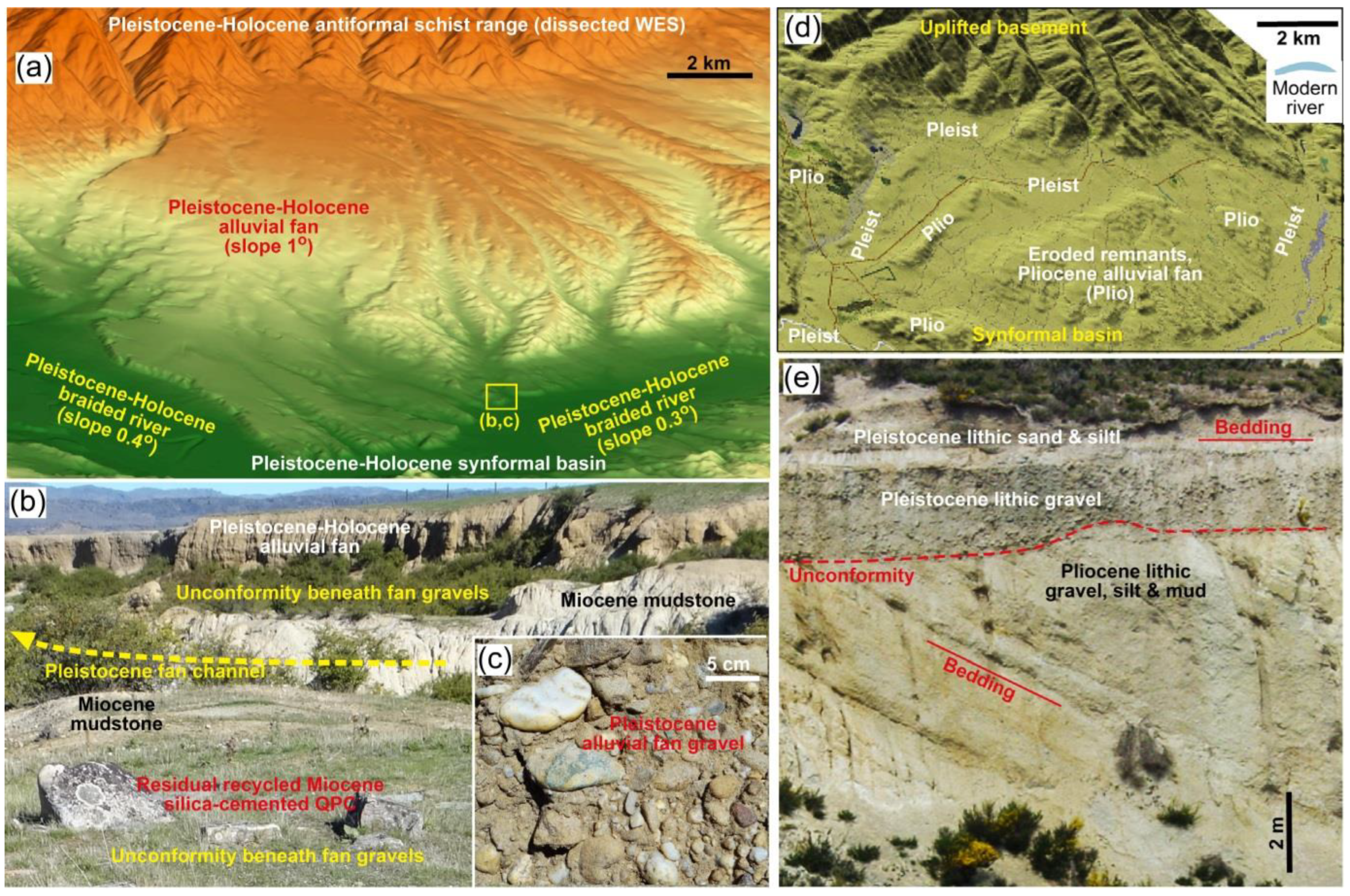
4.3. Non-Marine Unconformities

Non-marine unconformities in the South Island sedimentary basins are almost entirely fluvial in origin. They are numerous and widespread throughout all the non-marine parts of the sedimentary basins (Figure 5a). However, unlike the marine unconformities described above, the non-marine unconformities are highly irregular in geometry, are generally localised in scale (1–1000 m laterally), and are fluvial channels with a range of gradients (some very steep) and orientations related to the immediate eroding topography.
The erosion and recycling of pre-existing quartz pebble conglomerate sediments in the Otago sedimentary sequence has led to more rounded and better sorted quartz cobbles, pebbles, and sand, so that channelised unconformities are typically characterised by mature sediments with residual coarse clasts [20]. These processes occur at all scales from the metre scale, as in the internal unconformities in the Cretaceous fluvial sequence (Figure 7b) and in large (>50 m scale) erosion channels formed as the Eocene and Miocene recycling of quartz pebble conglomerates developed renewed deposits on low-relief surfaces in inland Otago (Figure 3 and Figure 7c,d) [25]. Recycled quartz pebble conglomerate deposits formed locally through the Pliocene and Pleistocene on hill slopes in the inland Otago foreland basin.
With the increased uplift and associated steeper relief in the Pliocene and Pleistocene, large alluvial fans developed internal to and at the foot of the rising basement ranges (Figure 8). These fans were deeply channelised, with multiple unconformities on the 10–100 m scale in width and the 1–10 m scale in depth [25,29]. Sediments were dominated by coarse lithic gravels rather than quartz pebble conglomerates, although a minor component of recycled quartz pebble conglomerate debris persisted (Figure 8). The fans grew unconformably over older sediments and basement and extended for tens of km2, but these underlying unconformities were also channelised (1–50 m scales). The ongoing uplift of mountain ranges also uplifted portions of early formed fans and resulted in the localised recycling of older gravels into younger fans (Figure 8d). New channelised unconformities developed during this process.
The Canterbury foreland basin is distinctly different from Otago in overall architecture, as most of the sediment from rising mountains has been deposited near sea level on a broad area of low relief formed by the coalescence of fluvial braid plains (Figure 9) [16]. To the west of this braid plain, a relatively narrow set of mountain ranges leads steeply back to the main Southern Alps. The broad braid plain has been formed through the Pliocene and Pleistocene by rivers with active gravel-dominated beds that are several kilometres wide, with braid channels that have migrated across the plain and intersected one another at various times. Modern rivers are currently cutting down through older gravels and recycling them but have a similar large-scale braided morphology (Figure 9a) [71]. The braid plain extended farther east during the Pleistocene, but coastal erosion is encroaching, and most sediment now heading offshore is fine-grained material that overlies the Holocene shelf unconformity (Figure 9b). Within the thick pile of lithic gravel that has resulted (Figure 9a–d), there are numerous fluvial unconformities that have formed on the scale of individual river courses: up to 3 km wide and ~100 km long (Figure 4a and Figure 9a). These unconformities are highly channelised internally, with 10–100-m-deep erosion channels, especially near the rising mountain front (Figure 9a,d). Even the most distal portions of the active braid plain are incised up to 10 metres to leave broad-flanking Pleistocene terraces (Figure 9d) [18,71].
At the edge of the mountain front, Pleistocene alluvial fans have spread eastwards to merge with the braid plain (Figure 9). These fans are even more channelised than the braid plains, and the internal unconformities are deeper, narrower, and more irregular than those on the braid plain. Farther inland, small basins and river valleys retain remnants of the Waipounamu Erosion Surface and associated marine sediments, but most of the inland area is underlain by an unaltered but deeply eroded basement where the Waipounamu Erosion Surface has been eroded to leave spiky mountains (Figure 4a) [18,68].

4.4. Placer Gold Concentrations in New Zealand

Most placer gold in the South Island has been derived from Cretaceous orogenic (gold only) vein systems in greenschist facies schists [72]. Placer accumulations began during the Cretaceous tectonic extension, when basement ridges that were uplifted on extensional basin margins were eroded, shedding detrital gold into the fluvial system [31]. This gold was accompanied by abundant barren metamorphic quartz vein debris from the basement schist, and rounded quartz pebbles are a major component of the earliest placer deposits. Subsequent tectonic uplift and erosion has caused the recycling of gold and quartz pebbles, the addition of new quartz debris and gold, and ongoing transport and redeposition, numerous times throughout the subsequent history of Otago and Southland [20,25]. The addition of abundant lithic debris from rising mountains, especially from the Pliocene to Holocene, has resulted in the considerable dilution of gold in fluvial systems.
In addition to the gold sources in the Cretaceous Otago schist, auriferous quartz veins were emplaced in the rising Southern Alps, beginning in the Miocene in Otago and continuing through the Pliocene and Pleistocene in the Canterbury–Westland mountains [21,22]. Detrital gold from these sources has contributed to placer accumulations in the Waiau Basin, the Canterbury foreland basin, and the Westland inboard wedge, primarily on beaches [9,21,22].
The all-time placer gold production from South Island sedimentary basins has been ~15 Moz (465 t), with ~8 Moz coming from fluvial placers of the Otago foreland basin complex and 7 Moz coming from the Westland inboard wedge [23]. The Westland placer gold was both fluvial and beach gold. The other major sources of gold are the operating Macraes orogenic (hard rock) mine, with all-time production exceeding 5 Moz from an endowment over 12 Moz [73], and ~3 Moz produced from orogenic deposits in Westland [23].
The onshore fluvial placer gold concentrations are focused in erosion channels within the fluvial sequences, from the Cretaceous to Holocene (Figure 8b and Figure 10). Alluvial fans and downstream rivers that flow on the basement are the most significant sites for placer gold accumulation (Figure 7c, Figure 8a,b and Figure 10). Mining typically focused on the lowest part of the erosion channels (the thalweg), where coarse gravel hosted heavy mineral concentrations with gold (Figure 10a,b), and gold concentrations declined rapidly away from the thalweg both laterally and vertically. Likewise, other heavy minerals were not concentrated at shallower levels within these channels and on the channel margins, and any heavy minerals have been substantially diluted by silicate gravel and sand and/or a silt matrix. This is particularly true in relatively young (Pliocene–Holocene) sediments that are dominated by lithic debris. These essentially barren gravels were removed in mining merely to provide access to the thalweg material below (Figure 10c). Channels were unconformably incised into the underlying basement (Figure 10a,c) or soft sediment (Figure 8b and Figure 10b,d) on scales from centimetres to tens of metres. In low-relief coastal environments, the channels are smaller and shallower, but heavy mineral concentrations are still preferentially found in the thalweg (Figure 10e), even if only a few cm deep (Figure 10f).
In overall gold production, marginal marine settings have been subordinate to the fluvial settings but constitute the most important placer accumulations associated with the Waiau, Westland, and Canterbury basins [9,23,30]. Gold in this setting occurs with other heavy minerals (including garnet, ilmenite) in localised seams (cm scale) on active beaches and in remnants of Pleistocene beaches both onshore and offshore (Figure 6c,d) [8,32]. These heavy mineral concentrates, with and without gold, are widespread at and immediately below the Pleistocene–Holocene offshore shelf unconformities [32,69]. Pleistocene beaches (above present sea level due to tectonic uplift or as high-stand levels) contain gold with heavy mineral concentrates in Westland and on the coast of the Waiau Basin, and these minerals are commonly recycled onto the Holocene unconformity at modern beaches [26,30,74]. Previous work on New Zealand analogues to Witwatersrand [8] has emphasised the importance of marginal marine processes in concentrating detrital gold, especially processes on the New Zealand beaches.

4.5. Mineral Transformations in Young Sediments

Shallow groundwater passage through Cretaceous–Pleistocene non-marine sediments, especially along unconformity zones where more permeable rocks occur, has resulted in post-depositional water–rock interactions that have transformed the minerals in the host rocks. The most prominent and widespread of these processes has affected basement rocks immediately below an unconformity and mineral changes and cementation in sediments immediately above the unconformity [75]. Some of these mineral changes have occurred under oxidising conditions, yielding ferric iron oxyhydroxides from labile iron minerals, but most have occurred under low-redox conditions in which ferrous iron-bearing secondary minerals have been formed. These processes involving shallow groundwater are similar to, and overlap with, the processes that form various components of the regolith in some continental areas [76,77].
The Otago and Southland basement rocks have been extensively altered to white kaolinite and green Fe2+–smectite beneath Cretaceous–Pleistocene sediments on a scale of 1–20 metres (Figure 7c and Figure 10e) [30,75]. Lithic clasts in overlying gravels have been variably converted into the same minerals, resulting in some clay cementation. Quartz pebble conglomerates overlying clay-bearing basement are commonly cemented by silica to form hard quartzite layers, in which the quartz clasts have been dissolved and recrystallised (Figure 7d). Elsewhere, the cementation of quartz pebble conglomerates by pyrite is common (Figure 11a). Most poorly sorted lithic gravel deposits with a lithic sand and silt matrix have developed some clay, leading to cementation, so that they become scarp-forming units (Figure 10a,b,d).
Low-redox clay formation is generally accompanied by authigenic pyrite (Figure 5b and Figure 11b), the oxidation of which contributes to cementation by ferric oxyhydroxides. Nodules of crystalline pyrite have grown in sediment interstices authigenically (Figure 11c). The rapid erosion of rocks containing primary and authigenic sulphide minerals can lead to the preservation of detrital sulphides if they are rapidly deposited in water-saturated sediments (Figure 11g), and some detrital sulphides can persist in these sediments for thousands or even millions of years (Figure 11c) [24,78].
Detrital gold is malleable and the irregular primary shapes are rapidly transformed into flat flakes by fluvial pebble collision processes (Figure 12a–c). With ongoing fluvial transport, including recycling events, the flakes become thin and are commonly folded (Figure 12b,c) [27,28,79]. In addition, gold mobility in these same groundwaters has caused substantial shape changes to detrital flakes, producing pure gold overgrowths that are intergrown with authigenic clay (Figure 12d,e). Major shape changes also occur on beaches, where wind-driven sand blasting transforms fluvial flakes into those with a toroidal and spheroidal morphology (Figure 12f,g) [8,26,30].

5. Discussion

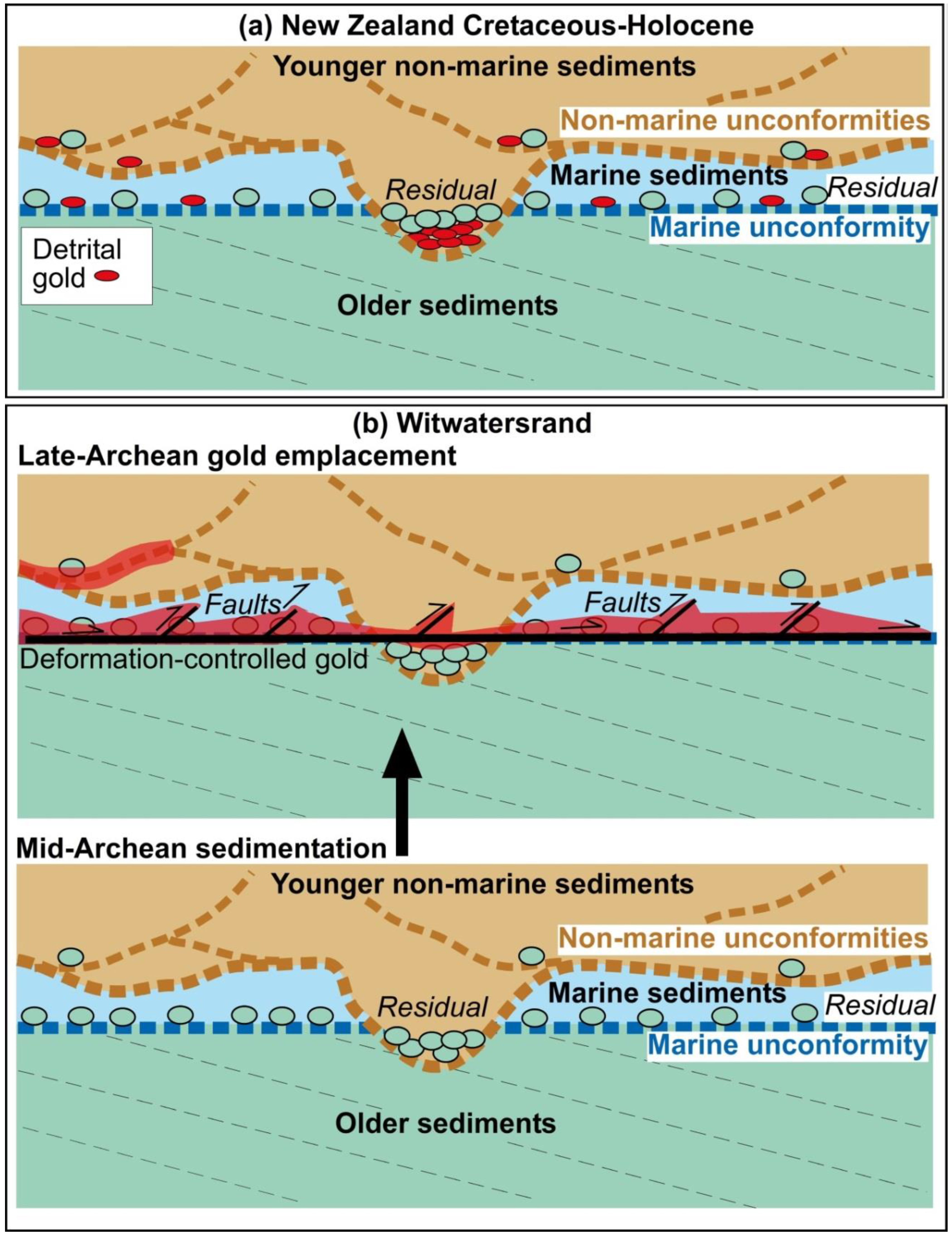
5.1. Marine Transgression Unconformity Surfaces Globally

The New Zealand examples of marine unconformities that we have described are representative of many similar features throughout the Phanerozoic geological record around the world. The Late Pleistocene–Holocene transgressional unconformities on the offshore shelf areas of New Zealand are also found on many, possibly most, shallow marine shelf zones around the world, because of eustatic sea level changes associated with Pleistocene glacial cycles that culminated in a sea level rise from the Last Glacial Maximum. Beringia (Bering Sea between Russia and Alaska) and Doggerland (North Sea) are the most famous examples, for their relevance to human migration immediately before the Holocene transgression and marine unconformity formation. Low-relief continental areas are susceptible to large-scale marine planation, such as Southern Namibia and the Nullarbor Plains of Southern Australia. The latter example is one of the largest such surfaces in the world, with a polygenetic post-Miocene history that includes substantial marine planation in the Pliocene [80], and the offshore extension was last planed during the Holocene marine transgression.
The Phanerozoic examples described above are resolvable because of the contrasting marine and non-marine fossil material in the various associated sediments, as well as via direct observations of the Holocene surfaces. These fossil-based distinctions are not available for the Archean Witwatersrand basin. Instead, the principal evidence for the marine origin of the Witwatersrand unconformities lies in their planar nature and large extent, features that are clearly not associated with non-marine unconformities in New Zealand (Figure 7, Figure 8 and Figure 9). The large-scale continuity of the overlying sediments in the upward-fining Witwatersrand reef package (Figure 2c) is also suggestive of a marine origin, as non-marine fluvial deposits in tectonic areas are typically discontinuous, as the New Zealand examples suggest. From this perspective, sections throughout New Zealand marine unconformities are broadly similar to a typical Witwatersrand reef package (Figure 2b,c versus Figure 5b and Figure 6b). Based on these observations of both the New Zealand and Witwatersrand unconformities, we deduce that the extensive planar Witwatersrand unconformities that have been exposed by mining had a marine transgressional origin.
Early Witwatersrand workers, without the benefit of modern tectonics or sequence stratigraphy, considered non-marine settings before concluding that a marine origin for the Witwatersrand reefs was more likely [7,10,11,81,82,83,84,85,86]. There have also been more recent advocates of a marine environment for the Witwatersrand, e.g., [12,52]. Despite the importance of the depositional environment (marine or non-marine), many of these papers are overlooked in subsequent reviews, and a non-marine setting has been tacitly assumed, e.g., [1,15].

5.2. Gold Placers on Marine Unconformities

In New Zealand, the beaches on the western shelf are the most efficient placer-forming environments in the marine setting (Figure 6) [8,32,74,87]. These beach placers, characterised by abundant Fe-Ti oxide accumulations (black sand), are also widespread on the offshore Holocene unconformity, in areas up to 50 km wide and hundreds of km long. However, these black sands have undergone reworking by storm waves as they became submerged during the sea level rise. Black sand beach placers in the Westland inboard wedge also contain significant fine-grained (generally <0.5 mm) detrital gold. Despite the delivery of abundant fluvial gold to present and past shorelines, there is only minor gold on the offshore shelf sediments at and immediately above the Holocene unconformity. Typical gold concentrations in this region are less than 0.1 g/t, typical particle sizes are <0.2 mm, and no significant placer concentrations have been identified [32]. Apparently, beach-based concentrations have been at least partially dispersed and diluted by wave reworking as the beaches were submerged during marine transgression.
The other potentially placer-bearing Holocene marine unconformity in New Zealand is on the Otago shelf, offshore of the most productive fluvial deposits of the Otago foreland basin complex. However, only minor fluvial gold is being transported by the low gradients of the rivers reaching this coast. For example, economic placer mining ceased ~90 km from the coast in the largest river (Clutha River, Figure 4c) [79]. Offshore gold exploration and surface sampling of the residual deposits on the Pleistocene–Holocene shelf (Figure 4c and Figure 5e) have failed to find any significant placer gold concentrations. Instead, any potential heavy mineral concentrations are diluted in the nearshore region with barren sand deposits [69,70].
As with the Holocene marine unconformities, the Waipounamu Erosion Surface is notable for the general lack of placer gold accumulations despite the abundance of fluvial gold in the coeval onshore regions. Some placer gold accumulations developed in marine glauconitic sand immediately above the Waipounamu Erosion Surface, where fluvial braid channels of quartz pebble conglomerate were eroded at the retreating coastline, especially during the Eocene stage of transgression [20]. However, these placers are of only local extent (km scale), and most of the Waipounamu Erosion Surface is defined by barren residual sediments (Figure 5b) [68].
Elsewhere in the world, very few Pleistocene–Holocene marine transgressional unconformities have placer mineral concentrations. The Nome placer gold deposits, in the Bering Sea, are a notable exception [88]. Similarly, offshore Namibia has placer diamond deposits on the Pleistocene–Holocene shelf [89]. A distinctive feature of both examples is that they are on coastlines with low volumes of sediment input from the adjacent landmasses, which would otherwise dilute the heavy mineral suite.

5.3. Fluvial Processes and Placer Gold

The Witwatersrand basin has been postulated as being dominated by fluvial sediments, especially alluvial fans and braid plains [14,15,90], and many studies start with an assumption of the fluvial setting. However, fluvial environments in modern settings, especially foreland basins, are entirely different from the sedimentary record of the Witwatersrand basin, especially with respect to the unconformities that we interpret to be of marine origin (above). Fluvial environments in New Zealand foreland basin settings are characterised by a short (1–10 km) set of alluvial fans emanating from uplifted mountain ridges, and these fans merge downstream into braided rivers (10–100 km scales) that dominate the landscape (Figure 4, Figure 6, Figure 8 and Figure 9). The gradients of most fans are typically low (1–2°; Figure 7a and Figure 8a), although small, steeper fans (up to 3°) can develop locally at the foot of steep mountains, where erosion rates are high (Figure 9e). Farther downstream, braided rivers have even lower gradients (<0.5°; Figure 8 and Figure 9).
The initial liberation of grains of gold from primary sources is limited during erosion at the heads of alluvial fans, and much of the gold remains encapsulated in lithic clasts. However, the recycling of uplifted paleo-placers readily provides gold to the fluvial system, and paleo-placers have been important sources of fluvial gold in the Otago foreland basin complex [20,22,79]. Once the detrital gold has moved to the distal parts of the alluvial fans and into the river system, transport in these low-gradient fluvial environments depends on the formation, folding, re-flattening, and refolding of flakes [26,27,28,79]. This gold is transported during flood events, along with lithic gravel, and the gold is widely dispersed through the gravel with little or no concentration [22].
Placer gold concentrations are invariably hosted in channels, and gold is best concentrated at or near an erosional unconformity at the base (the thalweg) of each channel (Figure 8 and Figure 10). These unconformities are highly irregular in shape and extent, as they are repeatedly intersected by younger migrating erosional channels at all scales, from metres to tens of kilometres wide and metres to tens of metres deep. The thalwegs became enriched in gold and other heavy minerals as a result of extensive winnowing by repeated flood events, which removed most of the sediment and left only a residue [22]. Before winnowing, the gold is greatly diluted by abundant barren lithic debris. This dilution process is most effectively displayed in the Canterbury foreland basin, where abundant lithic gravels in alluvial fans and braid plains have no significant concentrations of heavy mineral grains, including gold (Figure 9). The only (minor) gold concentrations occur on a beach near the mouth of the large Rakaia River (Figure 4a), where beach processes have allowed sufficient placer gold concentrations to be mined historically but on a small scale [9].
The relationship between placer gold and erosional fluvial channels on irregular unconformities is a worldwide phenomenon and has attracted mining for centuries [91,92,93]. We do not find these in the major Witwatersrand occurrences.

5.4. The Schematic Channels Interpreted in Witwatersrand Gold Mines

A significant shortcoming with all the sedimentological interpretations for the major Witwatersrand reefs is distinguishing schematic figures from quality data. The use of smoothed data without data points and lacking structural recordings means that correlations between gold and geology cannot be confirmed. Some maps from the 1970s with confidential gold data [34,94] are reproduced decades later, e.g., [50], with the gold data still confidential, despite the stopes being long closed.
The depiction of the major reefs being composed of linear channels [14,48,50] is difficult to rationalise with the planar orebodies because the planar character is well established by exploration drilling and actual mining. For the older mines of the Central Rand goldfield, a major sediment and gold entry point near Johannesburg is depicted with channels and gold distribution, e.g., [13] and many following publications. However, this interpretation is difficult to confirm without recorded gold grades or reef thickness data to reflect the sedimentology, and an understanding of the structural deformation. In the East Rand goldfield, there is a paucity of gold and sedimentological data due to several of the mines closing some years ago. In a rare example where actual gold grades are available, e.g., [50], the description of gold in channels is not convincing, the overall orebody appears planar, and structural deformation is overlooked. For the Central and East Rand goldfields, we suggest that some of the channels and entry points are derived from the genetic placer model, not solid data. The original entry points and channels [13] were meant to be conceptual and based upon their genetic biases; they have since been accepted as reality over time. The schema should only remain relevant whilst their assumed genetic model (placer) remains viable.
There are considerable sedimentological data for the stoped areas of the Basal Reef that are kilometres in width, and channels are drawn along the middle of higher-grade areas. A qualitative estimate using published maps suggests that most of the gold is between the schematic channels rather than within them [50]. Without recording deformational features, there remain multiple explanations for the measured bed thicknesses, with the original channels being only one possibility. Furthermore, there is no one-to-one relationship between gold and any channel thalweg; in fact, much of the gold appears to have been mined from outside the channel thalwegs. There are problems with the actual data for schematic channels, and these have been discussed previously [52,54]. There are undoubtedly linear channels in the Witwatersrand, but the geometry of the major economic gold distribution is planar and not primarily controlled by these channels.

5.5. Post-Depositional Changes

Onshore and offshore sediments are generally water-saturated after deposition, and observations of the New Zealand basin sediments show that chemical changes occur within the sediments on time scales of millions of years (Figure 8, Figure 10, Figure 11 and Figure 12), with only shallow burial (<0.5 km in some cases). The formation of kaolinite in lithic sediments and basement rocks was extensive, especially in non-marine settings. Much of this alteration of sediments occurred under low-redox conditions, resulting in widespread authigenic pyrite deposition in both marine and non-marine sediments (Figure 5b and Figure 11). Likewise, the authigenic formation of Fe2+-bearing phyllosilicates occurred under the prevailing low-redox conditions: smectite in onshore deposits and glauconite in offshore deposits. These latter mineral transformations involved silica mobility, with the dissolution of quartz clasts and quartz cementation.
In the Witwatersrand, it is difficult to determine the extent of the low-temperature mineral transformations that occurred before the metamorphic overprint. The sedimentary sequence has been metamorphosed to greenschist facies, with synchronous hydrothermal alteration at temperatures from 300 to 400 °C around 3 kbars or ~10 km depth [95]. These moderate-temperature processes induced extensive mineral transformations and lithification. Some of the authigenic processes described for the New Zealand basins are likely to have occurred in the Witwatersrand sequence. Quartz cementation, with the associated dissolution and shape changes of quartz clasts, probably occurred throughout the post-depositional history of the sediments. Quartz mobility is likely to have been especially pronounced in the quartz-rich sediments of the Witwatersrand reef packages, as is seen in New Zealand quartz pebble conglomerates and is pervasive in most Phanerozoic sedimentary sequences [96,97]. Likewise, some of the pyrite in New Zealand was authigenic to the unconformity zone soon after deposition. It is also possible that early formed authigenic pyrite, in non-marine sediments below an unconformity, was recycled as detrital pyrite clasts onto the marine unconformity of a reef package. The low-temperature recrystallisation of the authigenic pyrite occurred with increasing time and burial.

5.6. Critical Comparison: New Zealand Placers with Witwatersrand Gold

The Witwatersrand gold mine geology is distinctly different from the Phanerozoic channelised fluvial examples outlined above. We acknowledge that some erosion channels are present on and near the mined Witwatersrand unconformities, and some of these may be metres to several tens of metres deep and of unspecified width. However, there is little evidence of the significant enrichment of gold in the Witwatersrand thalwegs, even where the channels cut through a gold reef mined along an unconformity. The Witwatersrand unconformities are of primarily marine transgressional origin, albeit locally affected by fluvial channels. However, our observations of New Zealand and other global marine unconformities suggest that placer gold concentrations do not generally occur in offshore shelf environments. Hence, the Witwatersrand gold setting is paradoxical from a placer perspective: it is unlikely to be of fluvial origin because of the general lack of channels constraining the gold, and the gold is unlikely to be of placer origin in the marine transgression settings either.
Marine gold placers are relatively uncommon and account for 1% or less of global gold production. Nome is the largest goldfield in a marine environment, with production around 300 t, but this figure includes small auriferous quartz veins in a hinterland, detrital gold in creeks, gold in the back beach and active modern beach, and gold being dredged for 5 km offshore [88]. Westland NZ is also one of the largest but, as with Nome, much of its total production has come from onshore regions, adjacent to beach and marine accumulations. Neither Nome nor Westland is considered a viable analogue for the Witwatersrand.

6. Summary and Conclusions

Comparison with modern environments and especially the basins of the South Island, New Zealand suggests that the most productive Witwatersrand unconformities reflect marine transgressions. The planar Witwatersrand unconformity surfaces result from planation during marine incursions and are overlain by a reef package of conglomerates, followed by clean sandstone and then shale, reflecting deepening marine water (Figure 2c and Figure 13). These Witwatersrand unconformity surfaces of 10 s to 100 s km2 are much larger than most of the non-marine fluvial systems of braided rivers and particularly alluvial fans. The unconformities are directly responsible for two critical features that make Witwatersrand gold mineralisation so special: its high tonnage and its exceptional continuity. Globally, non-marine unconformities tend to have irregular geometry with variable gradients and orientation.
The planar Witwatersrand reefs do not match fluvial systems, which are highly channelised, or the much smaller beach deposits such as Nome Alaska or Westland NZ. Many of the channels and alluvial fan entry points shown on some Witwatersrand goldfield maps are schematic representations of a fluvial placer deposit and the locations of its entry points, fans, and channels in a conceptual model. However, we find little independent evidence for the entry points, and the planar distribution of gold does not match the geometry of the linear channels. In addition, it appears from past records that most gold has been mined from between the inferred channels. In the Witwatersrand, pressure solution has modified textures including pebbles, and the supposed preservation of original gold shapes, ventifacts, and driekanters (e.g., [8]) during greenschist facies metamorphism is speculative at best. The structural complexity has been significantly overlooked in sedimentological studies of Witwatersrand reef packages. Structural and alteration studies favour the gold being hydrothermal and tectonic, explaining the Witwatersrand appearance being unlike modern gold placers (Figure 13).
The world’s great Phanerozoic gold placer deposits, predominantly around the Pacific margins, occur close to the bases of erosional channels, where gold grains can settle due to their density and size, and all the less dense rock particles can be removed by the winnowing energy of fluvial systems. However, the gold-rich proximal parts of these fluvial systems are unlikely to be preserved in tectonically active areas. More distal braided river deposits, with their vast amounts of moving sediment at the margins of orogens, are more likely to be preserved, but these systems commonly involve the dilution of gold rather than enrichment. Beach environments concentrate gold where there are local primary sources of auriferous quartz veins but, globally, they are highly subordinate to modern placer gold deposits in fluvial systems.

Author Contributions

Conceptual development: D.C. and N.P.; South African geological components: N.P. and J.V.; New Zealand components: D.C., N.P. and J.V. Manuscript draft: N.P. Manuscript development: D.C., N.P. and J.V. All authors have read and agreed to the published version of the manuscript.

Funding

D.C. was funded by the University of Otago.

Data Availability Statement

All data for this study are available for cited references as summarised in the text, figures, and tables.

Acknowledgments

Useful feedback was provided by Hartwig Frimmel and especially Terence McCarthy on an earlier draft of this manuscript, although they do not necessarily agree with all the conclusions. Stephen Read (University of Otago) crafted the DEM base maps in Figure 4, Figure 8 and Figure 9. Constructive comments from four journal reviewers improved the presentation. We thank the editors for the invitation to be part of this Special Issue.

Conflicts of Interest

The authors declare no conflict of interest.

References

  1. Pretorius, D.A. Gold and uranium in quartz-pebble conglomerates. Econ. Geol. 1981, 75, 117–138. [Google Scholar]
  2. Phillips, G.N.; Law, J.D.M. Witwatersrand goldfields: Geology, genesis and exploration. SEG Rev. 2000, 13, 439–500. [Google Scholar]
  3. McCarthy, T.S. The Witwatersrand Supergroup. In The Geology of South Africa; Johnson, M.R., Anhaeusser, C.R., Thomas, R.J., Eds.; Geological Society of South Africa: Johannesburg, South Africa; Council of Geoscience: Pretoria, South Africa, 2006; pp. 155–186. [Google Scholar]
  4. Winter, H.D.L.R.; Brink, M.C. Chronostratigraphic subdivision of the Witwatersrand Basin based on Western Transvaal composite columns. S. Afr. J. Geol. 1991, 94, 191–203. [Google Scholar]
  5. Jolley, S.J.; Henderson, I.H.C.; Barnicoat, A.C.; Fox, N.P.C. Thrust-Fracture Network and Hydrothermal Gold Mineralization: Witwatersrand Basin, South Africa. In Fluid Flow and Mineralization; Special Publications; Mccaffrey, K.J.W., Lonergan, L., Wilkinson, J.J., Eds.; Geological Society: London, UK, 1999; Volume 155, pp. 153–165. [Google Scholar]
  6. Phillips, G.N. Metamorphism of the Witwatersrand goldfields: Conditions during peak metamorphism. J. Metamorph. Geol. 1987, 5, 307–322. [Google Scholar] [CrossRef]
  7. Bekker, G.F. The Witwatersrand Banket, with Notes on Other Gold-Bearing Pudding Stones; US Government Survey 18th Annual Report; US Government: Washington, DC, USA, 1897; Part V; pp. 153–184.
  8. Minter, W.E.L. Irrefutable detrital origin of Witwatersrand gold and evidence of eolian signatures. Econ. Geol. 1999, 94, 665–670. [Google Scholar] [CrossRef]
  9. Craw, D.; Youngson, J.H.; Leckie, D.A. Transport and concentration of detrital gold in foreland basins. Ore Geol. Rev. 2006, 28, 417–430. [Google Scholar] [CrossRef]
  10. Graton, L.C. Hydrothermal origin of the Rand gold deposits: Testimony of the conglomerates. Econ. Geol. 1930, 25, 1–185. [Google Scholar] [CrossRef]
  11. Verrezen, L. The facies technique of using sedimentology in valuation: A case study on the Vaal Reef palaeoplacer. Geocongress 1986, 86, 487–490. [Google Scholar]
  12. Bailey, A.C.; Law, J.D.M.; Cadle, A.B.; Phillips, G.N. The Zandfontein Quartzite Formation, a marine deposit in the Central Rand Group, Witwatersrand Supergroup. S. Afr. J. Geol. 1990, 93, 135–146. [Google Scholar]
  13. Brock, B.B.; Pretorius, D.A. Rand Basin Sedimentation and Tectonics. In The Geology of Some Ore Deposits in Southern Africa; Haughton, S.H., Ed.; Geological Society South Africa: Johannesburg, South Africa, 1964; pp. 549–599. [Google Scholar]
  14. Minter, W.E.L. Detrital gold, uranium, and pyrite concentrations related to sedimentology in the Precambrian Vaal Reef placer, Witwatersrand, South Africa. Econ. Geol. 1976, 71, 157–176. [Google Scholar] [CrossRef]
  15. Frimmel, H.E.; Minter, W.E.L. Recent developments concerning the geological history and genesis of the Witwatersrand gold deposits. S. Afr. Soc. Econ. Geol. Spec. Publ. 2002, 9, 17–45. [Google Scholar]
  16. Catuneanu, O. Flexural partitioning of the Late Archaean Witwatersrand foreland system, South Africa. Sed. Geol. 2001, 141, 95–112. [Google Scholar] [CrossRef]
  17. Turnbull, I.M.; Allibone, A.H. Geology of the Murihiku Area. In 1:250,000 Geological Map 20; Institute of Geological & Nuclear Sciences: Lower Hutt, NZ, USA, 2003. [Google Scholar]
  18. Cox, S.C.; Barrell, D.J.A. Geology of the Aoraki Area. In 1:250,000 Geological Map 15; Institute of Geological & Nuclear Sciences: Lower Hutt, NZ, USA, 2007. [Google Scholar]
  19. Craw, D.; Youngson, J.H.; Koons, P.O. Gold dispersal and placer formation in an active oblique collisional mountain belt, Southern Alps, New Zealand. Econ. Geol. 1999, 94, 605–614. [Google Scholar] [CrossRef]
  20. Youngson, J.H.; Craw, D.; Falconer, D.M. Evolution of Cretaceous–Cenozoic quartz-pebble conglomerate gold placers during basin formation and inversion, southern New Zealand. Ore Geol. Rev. 2006, 28, 451–474. [Google Scholar] [CrossRef]
  21. Upton, P.; Craw, D. Coeval emplacement and orogen-parallel transport of gold in oblique convergent orogens. Tectonophysics 2016, 693, 197–209. [Google Scholar] [CrossRef]
  22. Roy, S.; Upton, P.; Craw, D. Gold in the hills: Patterns of placer gold accumulation under dynamic tectonic and climatic conditions. Miner. Depos. 2018, 53, 981–995. [Google Scholar] [CrossRef]
  23. Williams, G.J. Economic Geology of New Zealand. Australas. Inst. Min. Met. Monogr. 1974, 4, 490. [Google Scholar]
  24. Falconer, D.M.; Craw, D. Supergene gold mobility: A textural and geochemical study from gold placers in southern New Zealand. In: Supergene environments, processes and products. Econ. Geol. Spec. Publ. 2009, 14, 77–93. [Google Scholar]
  25. Craw, D. River drainage reorientation during placer gold accumulation, southern New Zealand. Miner. Depos. 2013, 48, 841–860. [Google Scholar] [CrossRef]
  26. Craw, D.; Mitchell, M.; McCann, R.; Reay, A. Compositional variations and morphological evolution in platinum beach placers, southern New Zealand. Miner. Depos. 2013, 48, 81–97. [Google Scholar] [CrossRef]
  27. Craw, D.; Kerr, G.; Reith, F.; Falconer, D. Pleistocene paleodrainage and placer gold redistribution, western Southland, New Zealand. N. Z. J. Geol. Geophys. 2015, 58, 137–153. [Google Scholar] [CrossRef]
  28. Craw, D.; Kerr, G.; Falconer, D. Mineralogy and provenance of auriferous Waimumu Quartz Gravels, Southland, New Zealand. N. Z. J. Geol. Geophys. 2015, 58, 281–295. [Google Scholar] [CrossRef]
  29. Craw, D.; Hesson, M.; Kerr, G. Morphological evolution of gold nuggets in proximal sedimentary environments, southern New Zealand. Ore Geol. Rev. 2016, 80, 784–799. [Google Scholar] [CrossRef]
  30. Craw, D.; Kerr, G. Physical and chemical evolution of a Pleistocene marginal marine gold paleoplacer deposit, southern New Zealand. Ore Geol. Rev. 2021, 138, 104341. [Google Scholar] [CrossRef]
  31. Kerr, G.; Malloch, K.; Lilly, K.; Craw, D. Diagenetic alteration of a Mesozoic fluvial gold placer deposit, southern New Zealand. Ore Geol. Rev. 2017, 83, 14–29. [Google Scholar] [CrossRef]
  32. Fraser, N. Technical Report for Offshore Sampling of PP51979, West Coast; NZ Petroleum and Minerals, Mineral Report Series MR4761; Seafield Resources Ltd.: Toronto, ON, Canada, 2011; p. 89. [Google Scholar]
  33. Phillips, G.N.; Powell, R. Hydrothermal alteration in the Witwatersrand goldfields. Ore Geol. Rev. 2015, 65, 245–273. [Google Scholar] [CrossRef]
  34. Minter, W.E.L.; Hill, W.C.N.; Kidger, R.J.; Kingsley, R.J.; Snowden, P.A. The Welkom Gold Field. In Mineral Deposits of Southern Africa; Anhaeusser, C.R., Maske, S., Eds.; Geological Society of South Africa: Johannesburg, South Africa, 1986; Volume 1, pp. 497–539. [Google Scholar]
  35. Phillips, G.N. Anomalous gold in Witwatersrand shales. Econ. Geol. 1987, 82, 2179–2186. [Google Scholar] [CrossRef]
  36. Vearncombe, J.R.; McNaughton, N.J.; Porter, J.; Zi, J.-W.; Talavera, C. Age of the Archaean Murchison belt and mineralisation, South Africa. S. Afr. J. Geol. 2021, 124, 315–342. [Google Scholar] [CrossRef]
  37. Groves, D.I.; Goldfarb, R.J.; Robert, F.; Hart, C.J.R. Gold deposits in metamorphic belts: Overview of current understanding, outstanding problems, future research, and exploration significance. Econ. Geol. 2003, 98, 1–29. [Google Scholar]
  38. Armstrong, R.A.; Compston, W.; Retief, E.A.; Williams, I.S.; Welke, H.J. Zircon ion microprobe studies bearing on the age and evolution of the Witwatersrand triad. Precambrian Res. 1991, 53, 243–266. [Google Scholar] [CrossRef]
  39. Kositcin, N.; Krapĕz, B. Relationship between detrital zircon age-spectra and the tectonic evolution of the Late Archaean Witwatersrand Basin, South Africa. Precambrian Res. 2004, 129, 141–168. [Google Scholar] [CrossRef]
  40. Kositcin, N.; McNaughton, N.J.; Griffin, B.J.; Fletcher, I.R.; Groves, D.I.; Rasmussen, B. Textural and geochemical discrimination between zenotime of different origin in the Archaean Witwatersrand Basin, South Africa. Geochim. Cosmochim. Acta 2003, 67, 709–731. [Google Scholar] [CrossRef]
  41. Gaucher, C.; Frei, R. The Archean-Proterozoic Boundary and Great Oxidation Event. In Chemostratigraphy Across Major Chronological Boundaries; Sial, A.N., Gaucher, C., Ramkumar, M., Ferreira, V.P., Eds.; American Geophys Union Monograph; American Geophysical Union: Washington, DC, USA, 2018; Volume 240, pp. 35–46. [Google Scholar]
  42. Smith, A.J.B.; Beukes, N.J.; Gutzmer, J. The composition and depositional environments of Mesoarchean iron formations of theWest Rand Group of theWitwatersrand Supergroup, South Africa. Econ. Geol. 2013, 108, 111–134. [Google Scholar] [CrossRef]
  43. Burke, K.; Kidd, W.S.; Kusky, T.M. Archean foreland basin tectonics in the Witwatersrand Basin, South Africa. Tectonics 1986, 5, 439–456. [Google Scholar] [CrossRef] [Green Version]
  44. Catuneanu, O. Retroarc foreland systems—evolution through time. J. Afr. Earth Sci. 2004, 38, 225–242. [Google Scholar] [CrossRef]
  45. Barnicoat, A.C.; Henderson, I.H.C.; Knipe, R.J.; Yardley, B.W.D.; Napier, R.W.; Fox, N.P.C.; Kenyon, A.K.; Muntingh, D.J.; Strydom, D.; Winkler, K.S.; et al. Hydrothermal gold mineralization in the Witwatersrand Basin. Nature 1997, 386, 820–824. [Google Scholar] [CrossRef]
  46. Coward, M.P.; Spencer, R.M.; Spencer, C.E. Development of the Witwatersrand Basin, South Africa. In Early Precambrian Processes; Special Publications; Coward, M.P., Ries, A.C., Eds.; Geological Society: London, UK, 1995; Volume 95, pp. 243–269. [Google Scholar]
  47. Jolley, S.J.; Freeman, S.R.; Barnicoat, A.C.; Phillips, G.M.; Knipe, R.J.; Pather, A.; Fox, N.P.C.; Strydom, D.; Birch, M.T.G.; Henderson, I.H.C.; et al. Structural controls on Witwatersrand gold mineralisation. J. Struct. Geol. 2004, 26, 1067–1086. [Google Scholar] [CrossRef]
  48. Pretorius, D.A. The Geology of the Central Rand Goldfield. In The Geology of Some Ore Deposits of Southern Africa; Haughton, S.H., Ed.; Geological Society South Africa: Johannesburg, South Africa, 1964; Volume 1, pp. 63–108. [Google Scholar]
  49. Frimmel, H.E.; Groves, D.I.; Kirk, J.; Ruiz, J.; Chesley, J.; Minter, W.E.L. The formation and preservation of the Witwatersrand goldfields, the World’s largest gold province. Econ. Geol. 2005, 100, 769–797. [Google Scholar]
  50. Frimmel, H.E.; Nwaila, G.T. Geologic evidence of syngenetic gold in the Witwatersrand Goldfields, South Africa. Econ. Geol. Spec. Publ. 2020, 23, 645–668. [Google Scholar]
  51. Phillips, G.N.; Myers, R.E.; Palmer, J.A. Problems with the placer model for Witwatersrand gold. Geology 1987, 15, 1027–1030. [Google Scholar] [CrossRef]
  52. Phillips, G.N.; Myers, R.E. The Witwatersrand goldfields. II: An origin for Witwatersrand gold during metamorphism and associated alteration. Econ. Geol. Monogr. 1989, 6, 598–608. [Google Scholar]
  53. Barnicoat, A.C.; Phillips, G.M.; Law, J.D.M.; Walshe, J.L.; Phillips, G.N.; Fox, N.P.C. Refuting the Irrefutable: A New Look at a Well-Known Sample of Witwatersrand Gold Mineralisation. In Proceedings of the 2001: A Hydrothermal Odyssey Extended Abstracts, Townsville, Australia, 17–19 May 2001; Volume 59, pp. 16–17. [Google Scholar]
  54. Phillips, G.N.; Myers, R.E.; Law, J.D.M.; Bailey, A.C.; Cadle, A.B.; Beneke, S.D.; Giusti, L. The Witwatersrand goldfields. I: Post-depositional history, syn-sedimentary processes, and gold distribution. Econ. Geol. Monogr. 1989, 6, 585–597. [Google Scholar]
  55. Wiebols, J.H. Note on chloritoid in the Witwatersrand System. Trans. Geol. Soc. S. Afr. 1961, 64, 85–98. [Google Scholar]
  56. Austin, M.A. Topographic Control of Facies in the Proterozoic Carbon Leader Placer. In Proceedings of the Geocongress ’86; Extended Abstracts: An International Earth Science Congress, Johannesburg, South Africa, 7–11 July 1986; Geological Society of South Africa: Johannesburg, South Africa, 1986; pp. 437–440. [Google Scholar]
  57. Parnell, J. Petrographic evidence for emplacement of carbon into Witwatersrand conglomerates under high fluid pressure. Sed. Res. 1999, 69, 164–170. [Google Scholar] [CrossRef]
  58. Palmer, J.A.; Phillips, G.N.; McCarthy, T.S. Paleosols and their relevance to Precambrian atmospheric composition. J. Geol. 1989, 97, 77–92. [Google Scholar] [CrossRef] [PubMed]
  59. Phillips, G.N. Widespread fluid infiltration during metamorphism of the Witwatersrand goldfields: Generation of chloritoid and pyrophyllite. J. Metam. Geol. 1988, 6, 311–332. [Google Scholar] [CrossRef]
  60. Berlenbach, J.W. Aspects of bedding-parallel faulting associated with the Ventersdorp Contact Reef on the Kloof gold mine. S. Afr. J. Geol. 1995, 98, 335–348. [Google Scholar]
  61. Jolley, S.J.; Stuart, G.W.; Freeman, S.R.; Knipe, R.J.; Kershaw, D.; Mcallister, E.; Barnicoat, A.C.; Tucker, R.F. Progressive evolution of a late orogenic thrust system, from duplex development to extensional reactivation and disruption: Witwatersrand Basin, South Africa. In Deformation of the Continental Crust: The Legacy of Mike Coward; Special Publications; Geological Society: London, UK, 2007; Volume 272, pp. 543–569. [Google Scholar]
  62. Greenberg, R. Structure-gold relationships as revealed by some Witwatersrand mine survey plans. Trans. Inst. Min. Metall. 1964, 73, 1–10. [Google Scholar]
  63. Pitts, P.A. Aspects of Shear Strain in the East Rand Basin. In Natural Sciences; Rand Afrikaans University: Johannesburg, South Africa, 1990; p. 145. [Google Scholar]
  64. Mullins, M. Economic Gold Mineralisation in Shear Zones. In Rand Leases Gold Mine: Other Reefs Symposium; Extended Abstracts; Geological Society of South Africa: Johannesburg, South Africa, 1989; pp. 85–86. [Google Scholar]
  65. Roering, C.; Smit, C.A. Bedding parallel shear thrusting and quartz vein formation in Witwatersrand quartzite. J. Struct. Geol. 1987, 9, 419–427. [Google Scholar] [CrossRef]
  66. Coetzee, D.S.; Van Reenen, D.D.; Roering, C. Quartz vein formation, metamorphism, and fluid inclusions associated with thrusting and bedding-parallel shear in Witwatersrand quartzites, South Africa. S. Afr. J. Geol. 1995, 98, 371–381. [Google Scholar]
  67. Els, B.G. The question of alluvial fans in the auriferous Archaean and Proterozoic successions of South Africa. S. Afr. J. Geol. 1998, 101, 17–26. [Google Scholar]
  68. Landis, C.A.; Campbell, H.J.; Begg, J.G.; Mildenhall, D.C.; Paterson, A.M.; Trewick, S.A. The Waipounamu erosion surface: Questioning the antiquity of the New Zealand land surface and terrestrial fauna and flora. Geol. Mag. 2008, 145, 173–197. [Google Scholar] [CrossRef] [Green Version]
  69. Carter, R.M.; Carter, L.; Williams, J.J.; Landis, C.A. Moderm and Relict Sedimentation on the South Otago Continental Shelf, New Zealand. In New Zealand Oceanographic Institute Memoir; New Zealand Oceanographic Institute Memoir: Wellington, New Zealand, 1985; Volume 93, p. 43. [Google Scholar]
  70. Carter, L.; Carter, R.M. Holocene evolution of the nearshore sand wedge, South Otago continental shelf, New Zealand. N. Z. J. Geol. Geophys. 1986, 29, 413–424. [Google Scholar] [CrossRef]
  71. Leckie, D.A. Canterbury Plains, New Zealand: Implications for sequence stratigraphic models. AAPG Bull. 1994, 78, 1240–1256. [Google Scholar]
  72. Mortensen, J.K.; Craw, D.; MacKenzie, D.J.; Gabites, J.E.; Ullrich, T. Age and origin of orogenic gold mineralisation in the Otago Schist belt, South Island, New Zealand: Constraints from lead isotope and 40Ar/39Ar dating studies. Econ. Geol. 2010, 105, 777–793. [Google Scholar] [CrossRef]
  73. Craw, D.; MacKenzie, D. Macraes Gold Deposit, New Zealand. In Springer Briefs in World Mineral Deposits; Springer: Cham, Switzerland, 2016; p. 130. ISBN 978-3-319-35158-2. [Google Scholar]
  74. Ritchie, T.; Scott, J.; Craw, D. Garnet compositions track longshore migration of beach placers in western New Zealand. Econ. Geol. 2019, 114, 513–540. [Google Scholar] [CrossRef]
  75. Chamberlain, C.P.; Poage, M.A.; Craw, D.; Reynolds, R.C. Topographic development of the Southern Alps recorded by the isotopic composition of authigenic clay minerals, South Island, New Zealand. Chem. Geol. 1999, 155, 279–294. [Google Scholar] [CrossRef]
  76. Butt, C.R.M. Genesis of supergene gold deposits in the lateritic regolith of the Yilgarn Block, Western Australia. Econ. Geol. Monogr. 1989, 6, 460–470. [Google Scholar]
  77. Anand, R.R.; Paine, M. Regolith geology of the Yilgarn craton. Aust. J. Earth Sci. 2002, 49, 3–162. [Google Scholar] [CrossRef]
  78. Craw, D. Placer gold and associated supergene mineralogy at Macraes Flat, East Otago, New Zealand. N. Z. J. Geol. Geophys. 2017, 60, 353–367. [Google Scholar] [CrossRef]
  79. Youngson, J.H.; Craw, D. Variation in placer style, morphology and gold particle behaviour down gravel-bed rivers: An example from the Shotover/Arrow-Kawarau-Clutha River system, Otago, New Zealand. Econ. Geol. 1999, 94, 615–634. [Google Scholar] [CrossRef]
  80. James, N.P.; Bone, Y.; Carter, R.M.; Murray-Wallace, C.V. Origin of the late Neogene Roe Plains and their calcarenite veneer: Implications for sedimentology and tectonics in the Great Australian Bight. Aust. J. Earth Sci. 2006, 53, 407–419. [Google Scholar] [CrossRef]
  81. Gregory, J.W. The Origin of the Gold in the Rand Banket. Trans. Geol. Soc. S. Afr. Annex. 1908, 17, 2–41. [Google Scholar]
  82. Young, R.B. The Banket: A Study of the Auriferous Conglomerates of the Witwatersrand and the Associated Rocks; Gurney and Jackson: London, UK, 1917; p. 125. [Google Scholar]
  83. Sharpe, J.M. The economic auriferous banket of Upper Witwatersrand Beds and their relationship to sedimentation features. Geol. Soc. S. Afr. Trans. 1949, 52, 265–300. [Google Scholar]
  84. Brink, M.C. Tektoniese en Stratigrafiese Ontwikkeling van Die Witwatersrand-Supergroep en Verwante Gesteentes in Die Gebied Noord en oos van Klerksdorp. Ph.D Thesis, Randse Afrikaanse University, Johannesburg, South Africa, 1986; p. 330. [Google Scholar]
  85. Verrezen, L. Sedimentology of the Vaal Reef Palaeoplacer in the Western Portion of Vaal Reef Gold Mine. Master’s Thesis, Randse Afrikaanse Universiteit, Johannesburg, South Africa, 1987. [Google Scholar]
  86. Cadle, A.; Bailey, A.; Law, J.; Phillips, G.N. How valid is the fluvial model for the Witwatersrand Basin? Soc. Econ. Paleontol. Mineral. 1987, 4, 11. [Google Scholar]
  87. Christie, A.B. Exploration of Placer Titanomagnetite Iron Sand Deposits Offshore from the West Coast of the North Island. In Mineral Deposits of New Zealand: Exploration and Research; Christie, A.B., Ed.; Australasian Institute of Mining and Metallurgy: Carlton, Australia, 2016; Volume 31, pp. 443–450. [Google Scholar]
  88. Sainsbury, C.L. Geology, ore deposits and mineral potential of the Seward Peninsula, Alaska. US Bur. Mines Open File Rep. 1975, 73, 108. [Google Scholar]
  89. Coetzee, C.B. Mineral Resources of the Republic of South Africa Handbook 7; Geological Survey South Africa: Johannesburg, South Africa, 1976; pp. 17–30. [Google Scholar]
  90. Pretorius, D.A. The depositional environment of the Witwatersrand gold fields: A chronologic review of speculations and observations. Miner. Sci. Eng. 1975, 7, 18–47. [Google Scholar]
  91. Boyle, R.W. The geochemistry of gold and its deposits. Geol. Surv. Can. Bull. 1979, 280, 579. [Google Scholar]
  92. Hughes, M.J.; Phillips, G.N.; Carey, S.P. Giant placers of the Victorian gold province. SEG Newsl. 2004, 56, 11–18. [Google Scholar] [CrossRef]
  93. Garnett, R.H.T.; Bassett, N.C. Placer deposits. Econ. Geol. 2005, 100, 813–843. [Google Scholar]
  94. Minter, W.E.L. A sedimentological synthesis of placer gold, uranium and pyrite concentrations in Proterozoic Witwatersrand sediments. In Fluvial Sedimentology; Miall, A.D., Ed.; Canadian Society of Petroleum Geologists: Calgary, AB, Canada, 1978; Volume 5, pp. 801–829. [Google Scholar]
  95. Phillips, G.N.; Zhou, T.; Powell, R. Metamorphic temperature variations among Witwatersrand goldfields: Evidence from the pyrophyllite—chloritoid—chlorite mineral assemblage. S. Afr. J. Geol. 1997, 100, 393–404. [Google Scholar]
  96. Nenna, F.; Aydin, A. The formation and growth of pressure solution seams in clastic rocks: A field and analytical study. J. Struct. Geol. 2011, 33, 633–643. [Google Scholar] [CrossRef]
  97. Haile, B.G.; Line, L.H.; Klausen, T.G.; Olaussen, S.; Eide, C.H.; Jahren, J.; Hellevang, H. Quartz overgrowth textures and fluid inclusion thermometry evidence for basin-scale sedimentary recycling: An example from the Mesozoic Barents Sea Basin. Basin Res. 2020, 33, 1697–1710. [Google Scholar] [CrossRef]
Figure 8. Onshore alluvial fans in the Otago foreland basin complex [25]. (a) Oblique digital topography of a large Pleistocene fan emanating from a rising antiformal range (vertical scale exaggerated ×2 for clarity). (b) Distal portion of fan in (a), showing unconformity between fan gravels and underlying Miocene sediments, exposed by placer gold miners following an erosion channel. Numerous large boulders of silica-cemented Miocene quartz pebble conglomerates litter the exposed unconformity. (c) Typical fan gravels in (a,b), showing abundant lithic sediments (brown) and recycled Miocene quartz pebble conglomerates (white). (d) Oblique digital topography of an inland basin margin, showing remnants of a large Pliocene alluvial fan (Plio) that has been eroded and recycled into Pleistocene fluvial deposits (Pleist). (e) Unconformity between deformed, tilted and eroded Pliocene distal fan sediments (below; fan as in (d)) and Pleistocene lithic sediments (above), in an outcrop exposed by down-cutting of a Holocene river.
Minerals 13 01041 g008
Figure 9. Onshore alluvial fans and associated braid plains in the Canterbury foreland basin. (a) Digital topography (exaggerated vertical scale) of the mountain front of the main Canterbury foreland basin, with typical fluvial slope angles of Pleistocene surfaces and terraces of a major Holocene river (right) that has a braid plain on the floor of a broad erosional channel cut >100 m into older gravels. (b) Aerial view (from Google Earth) of coastline at foot of the braid plain, with active plumes of fine sediments extending offshore onto the Holocene shelf unconformity that is transgressing coastwards (Figure 3a). (c) Typical braid channel gravels, with coarse rounded lithic cobbles in a matrix of lithic sand and silt. (d) Sketch cross-section, modified from [18], through the mountain front to the edge of the plains (as in (b)), with deformed Pleistocene gravels resting unconformably on deformed older basin sequence. (e) Aerial view (from Google Earth) of an active Holocene alluvial fan, with white active braid channels, extending from a steep side-stream into an active braid plain in an axial river in a glaciated inland valley.
Minerals 13 01041 g009
Figure 10. Examples of fluvial channels at unconformities that have been mined for gold in Late Cenozoic sedimentary sequence in the southern South Island. Examples (ad) are in inland Otago foreland [22,25,29] and (e,f) are on the south coast, at the margin of the Waiau basin [30]. (a) Poorly sorted angular basement debris has accumulated in a proximal alluvial fan erosion channel, with gold concentration at the metre scale in channel thalweg (at tunnel). (b) Large-scale sluicing of distal Pleistocene fan gravels focused on the floors of erosion channels in underlying unconformity. (c) Mining in a narrow gorge followed Pleistocene and modern channel floors cut into basement. (d) Mine face in a Pliocene distal fan gravel, with gold concentrated with coarsest cobbles in channels eroded into consolidated silt. (e) Gravel erosion channel in basement beneath Pleistocene marginal marine sediments contains the only economic gold in a modern mine. (f) Small-scale heavy mineral concentrations (black sand with Au) are reworked into braid channels in temporary fans on a daily basis by shallow streams crossing a beach at low tide.
Minerals 13 01041 g010
Figure 11. Principal textures of sulphide minerals in Cretaceous–Holocene terrestrial sediments [24,27,30,31] (a) Authigenic pyrite cement (grey) in Cretaceous quartz pebble conglomerate (QPC) overlying an internal unconformity on a coal seam. (b) Authigenic pyrite veinlets (light grey) form a network through groundwater-altered Cretaceous lithic quartz pebble conglomerates, with associate ferrous iron-bearing authigenic clays. (c) Disaggregated Pliocene quartz pebble conglomerates heavy mineral fraction, with fragments of authigenic pyrite and a particle of detrital arsenopyrite. (d) Authigenic pyrite grown in interstices of a Pliocene QPC and transformed into authigenic marcasite. Authigenic clay coating has been overgrown by marcasite in places. Polished section with partially crossed polars to enhance internal structure. (e) Intergrown authigenic gold and marcasite in Pliocene quartz pebble conglomerates. Marcasite has blue tinge because of carbon coat for electron microscopy. (f) Crystalline authigenic pyrite cement in Pleistocene lithic sand. (g) Detrital sulphides from Holocene lithic gravel near an exposed orogenic deposit [73,78]: partially rounded arsenopyrite (top), coarse angular pyrite (left), and rounded pyrite (lower right).
Minerals 13 01041 g011
Figure 12. Typical morphological features of detrital gold in the southern South Island: (ae) in inland Otago basin complex [27,28,29,31]; (f,g) at the margin of the Waiau basin [30]. (a) Proximal coarse particle derived from a supergene enrichment zone in Mesozoic schist and recycled through Miocene quartz pebble conglomerates into lithic Pleistocene gravels. (b) Distal thin fluvial flakes with folded rims from Pliocene quartz pebble conglomerates, recycled from Miocene quartz pebble conglomerates. (c) Sections through distal flakes (etched to show internal structure) that were recycled from Miocene quartz pebble conglomerates into Pleistocene lithic gravels. (d) Cretaceous fluvial flake with rough surface formed by authigenic gold remobilisation. (e) SEM image of complex plates of authigenic gold (white) that has overgrown authigenic clay on the exterior surface of Cretaceous fluvial gold. (f) Toroidal and spheroidal gold formed by sand blasting of fluvial flakes on Pleistocene–Holocene beaches. (g) Section through beach gold as in (f), accompanied by detrital platinum (white).
Minerals 13 01041 g012
Figure 13. Cartoon summary of the comparisons of unconformity features between (a) Southern New Zealand and (b) Witwatersrand basin. Planar marine unconformities have residual conglomerates but little or no detrital gold. Non-marine unconformities are not planar, are highly channelised and irregular, and may have detrital gold in their thalwegs. Our conclusions emphasise the marine origin of the mid-Archean planar Witwatersrand unconformities, followed by late Archean hydrothermal gold mineralisation after deformation and metamorphism.
Minerals 13 01041 g013
Table 1. Summary of key features of New Zealand sedimentary basins relevant to placer gold deposits (references in text). Otago description includes Southland. QPC = quartz pebble conglomerate.
BasinOtagoWaiauCanterburyWestland
StyleForeland complexOblique forelandForelandInboard wedge
TectonicsCompressionTranspressionCompressionTranspression
Age of foreland sedimentsMiocene–HoloceneMiocene–HoloceneMiocene–HoloceneMiocene–Holocene
Crustal thickness~25 km~25 km<20 km>30 km
Basement rocksSchistGreywacke, crystallineGreywackeSchist, crystalline
Basement exposureAt and above sea levelBelow sea levelBelow sea levelAt and below sea level
Precursor Cretaceous–Oligocene extensional sedimentsCoastal, up to 1 km thick; eroded from inlandLocally >3 km thickLocally >2 km thickMostly eroded; minor remnants
Placer agesCretaceous–HoloceneMiocene–HoloceneModernPleistocene–Holocene
Fluvial placersAbundant; 8 Moz productionMinor productionNegligible; dilution dominatesCommon, post-glacial;
7 Moz production
Fluvial placer
unconformity control
Basement; syn-sedimentary deformation and erosionLocal basement ribsLocal basement ribsLocal basement exposures; syn-sedimentary deformation and erosion
Beach placersRare, negligible productionAbundant; minor productionNegligible productionCommon; moderate production
Gold sourceOtago; Mesozoic veins in schistOtago: Miocene veins
± Mesozoic veins
Southern Alps; Plio-Pleistocene veinsSouthern Alps;
Plio-Pleistocene veins
Placer recyclingFrequent, Cretaceous–
Holocene uplift and erosion
created QPCs
Common;
Pleistocene uplift and erosion
No dataCommon;
Pleistocene sea-level changes
Age gap, source-to-placerWide; 50–110 MaCoeval to ~20 MaCoeval to ~5 MaCoeval to ~5 Ma
Placer hostsLithic conglomerates;
Cretaceous–Pleistocene QPC
Lithic conglomerates
and sands
Lithic conglomerates and sandsLithic conglomerates
and sands
Principal associated heavy mineralsMagnetite, hematite, garnet, zirconIlmenite, garnet, zircon,
platinum
Zircon, epidoteIlmenite, garnet, zircon
Gold particle sizes2 to 0.1 mm flakes; rare cm nuggets1 mm flakes to 0.1 mm toroids and spheroids<0.5 mm flakes,
incipient toroids
2 to 0.1 mm flakes;
rare nuggets
Gold transport
direction,
Miocene–Holocene
Various; rivers from uplifted ranges across basin complexSW orogen-parallel rivers;
SE longshore drift
SE orogen-oblique riversNW orogen-normal rivers;
NE longshore drift
Clay alteration in
placers
Widespread in basement and sediments, Cretaceous–PlioceneLocalised in Pleistocene
sediments and basement
NilNil
Silica cementation associated with placersCommon in QPCs; recycled siliceous cobbles in Cretaceous–Holocene sedimentsNilNilNil
Authigenic pyrite in placersCommon, Cretaceous–
Pliocene; minor
detrital sulphides
Localised; Miocene–
Pleistocene
NilNil
Disclaimer/Publisher’s Note: The statements, opinions and data contained in all publications are solely those of the individual author(s) and contributor(s) and not of MDPI and/or the editor(s). MDPI and/or the editor(s) disclaim responsibility for any injury to people or property resulting from any ideas, methods, instructions or products referred to in the content.

