Article

Sedimentary Environments and Paleoclimate Control of the Middle Miocene Balikpapan Group, Lower Kutai Basin (Indonesia): Implications for Evaluation of the Hydrocarbon Potential

1
Department of Geology, Faculty of Earth Sciences, Geography and Astronomy, University of Vienna, 1090 Vienna, Austria
2
Geological Engineering Study Program, Sekolah Tinggi Teknologi Migas Balikpapan, Balikpapan 76127, Indonesia
*
Author to whom correspondence should be addressed.
Minerals 2023, 13(10), 1259; https://doi.org/10.3390/min13101259
Submission received: 17 August 2023 / Revised: 21 September 2023 / Accepted: 22 September 2023 / Published: 27 September 2023

Abstract

:
Sedimentary organic matter concentrated in source rocks forms the main source for the formation of hydrocarbons. Its deposition and preservation are strongly controlled by the depositional environment and paleoclimate. This study evaluates the paleoenvironment and the paleoclimatic controls of sediments in the Middle Miocene Balikpapan Group, Mahakam Delta of the Lower Kutai Basin, Indonesia. The sedimentary succession of the Mentawir Formation, encountered in three wells (MHK 1, MHK 3, and MHK 4), contains interbedded sandstones, siltstones, shales, and coal. Gamma ray log analysis has revealed four facies associations: (a) funnel-, (b) bell-, (c) cylindrical-, and (d) bow-shaped patterns, which, together with sedimentological and mineralogical analysis, suggest a fluvio-deltaic depositional environment during the Middle Miocene in the study area. Sedimentary successions from wells MHK 1 and MHK 3 comprise interbedded sandstone and siltstones and are interpreted to represent repeatedly occurring delta plain, delta front, and prodelta deposits. The succession encountered in well MHK 4 mostly consists of amalgamated sandstones and indicates a predominantly fluvial to upper delta plain environment with distributary channels and crevasse splays interbedded with only thin delta front deposits. X-ray diffractionclay fraction analysis shows that the <2 μm clay-sized fraction consists of kaolinite (38%–67%), illite (14%–29%), chlorite (2%–17%), and mixed-layer illite/smectite (I/S) (14%–30%). Kaolinite formation and abundance indicates a hinterland climate classified as type Af (tropical rainforest) and intensive chemical weathering conditions in the source areas related to tropical to sub-tropical climates with high precipitation. Under such climatic conditions, kaolinite and I/S mixed-layer minerals are preferentially formed because the characteristic ions, K+, Na+, Ca2+, and Fe2+, are leached away. Thus, the production, transport, distribution, and preservation of sedimentary organic matter in the onshore Mentawir Formation of the Balikpapan Group are predominantly controlled by the humid tropical climate and fluvio-deltaic processes.

1. Introduction

The origin, generation, and preservation of hydrocarbons are significantly influenced by sedimentary environments because they control the formation and distribution of both source and reservoir rocks [1,2]. The Kutai Basin and the Mahakam Delta have been regarded as a significant hydrocarbon province, in which oil and gas are primarily of humic origin [3,4,5]. The modern Mahakam Delta area has a wet, equatorial climate with high humidity and rain all year round [6]. Tidal range decreases from the delta front to the upstream Mahakam River and its value ranges from 1 to 3 m [7]. The tropical climate and fluvio-deltaictidal processes are also assumed to be the most important factors for the formation of petroleum source rocks in the Kutai Basin during the Miocene.
Fine-grained, organic-rich sedimentary rocks can generate hydrocarbons at higher temperatures and pressures [8,9,10,11,12]. Primary organic matter enrichment benefits from high primary production and adequate organic matter (OM) preservation conditions [1,13,14,15]. Primary productivity and preservation are directly and indirectly influenced by environmental factors such as paleoclimate, salinity, detrital input, and redox conditions [16,17,18]. More specifically, high primary production, low detrital input, and anoxic conditions are beneficial for organic matter enrichment and preservation. Furthermore, paleoclimate exerts a major external control on the depositional environment regarding parameters such as paleotemperatures and precipitation, which in turn control weathering, erosion, and terrestrial input.
Clay minerals provide a significant tool that can be used for the interpretation and understanding of problems related to paleoclimatic variations [19]. Warm and humid climatic conditions with strong chemical weathering are typified by the formation of kaolinitic clay minerals, whereas dry and arid climates with dominant physical weathering induce the formation of illite because these two-layer/three-layer clay minerals are conditioned by climate. Thus, climate exerts the major controlling factor over the clay type that can be formed at a particular point in time in a given location [20].
Since the Early Miocene, the Kutai Basin, the largest basin in Indonesia, has become a major fluvio-deltaic depocenter filled with siliciclastic sediments. From the Early Miocene to the Pliocene, rapid sedimentation indicates the major basin’s ongoing sediment supply. The hydrocarbon productive section (the Balikpapan Group) contains shales, sand, and coal, with carbonates being minor in terms of volume and extent. In the studied petroleum system of the Kutai Basin, the primary source rocks consist of organic-rich mudrock, coal seams, and organic-rich sandy facies. These rocks were deposited in fluvial, deltaic, and tidal settings, largely similar to the modern active Mahakam Delta [21,22,23]. The oil-generating potential in the Lower Kutai Basin, generally type III organic matter, is exceptionally high. In most cases, coal as a hydrocarbon source is more important than organic-rich shales. Depending on its rank, coal mainly consists of huminite and vitrinite macerals (type-III kerogen). With increases in rank, liptinite macerals (type II) lose their H-rich compounds. Shales contain phytoclasts (vitrinite and inertinite) and dispersed amorphous organic matter in a claymineral matrix [24,25]. Hence, coal seams could have source rock generation potential. Nevertheless, they are generally considered gas–prone, and high-rank coals are more prone to produce liquid hydrocarbon [25,26,27].
The shales and coal facies of the Balikpapan Group have relatively high organic carbon contents; therefore, they could be generally good source rocks and an example for coal-derived oil and gas systems [28,29]. The origin of organic matter in the Kutai Basin is generally believed to be derived from plant debris such as bark, wood, and leaves mostly influenced by a varying degree of chemical weathering and humid paleoclimate conditions [23,24,30,31,32]. This study evaluates the depositional palaoenvironment and paleoclimatic significance during deposition of the Balikpapan Group sediments in Middle Miocene period based on clay mineral analysis complemented with gamma ray log interpretation from available wells.

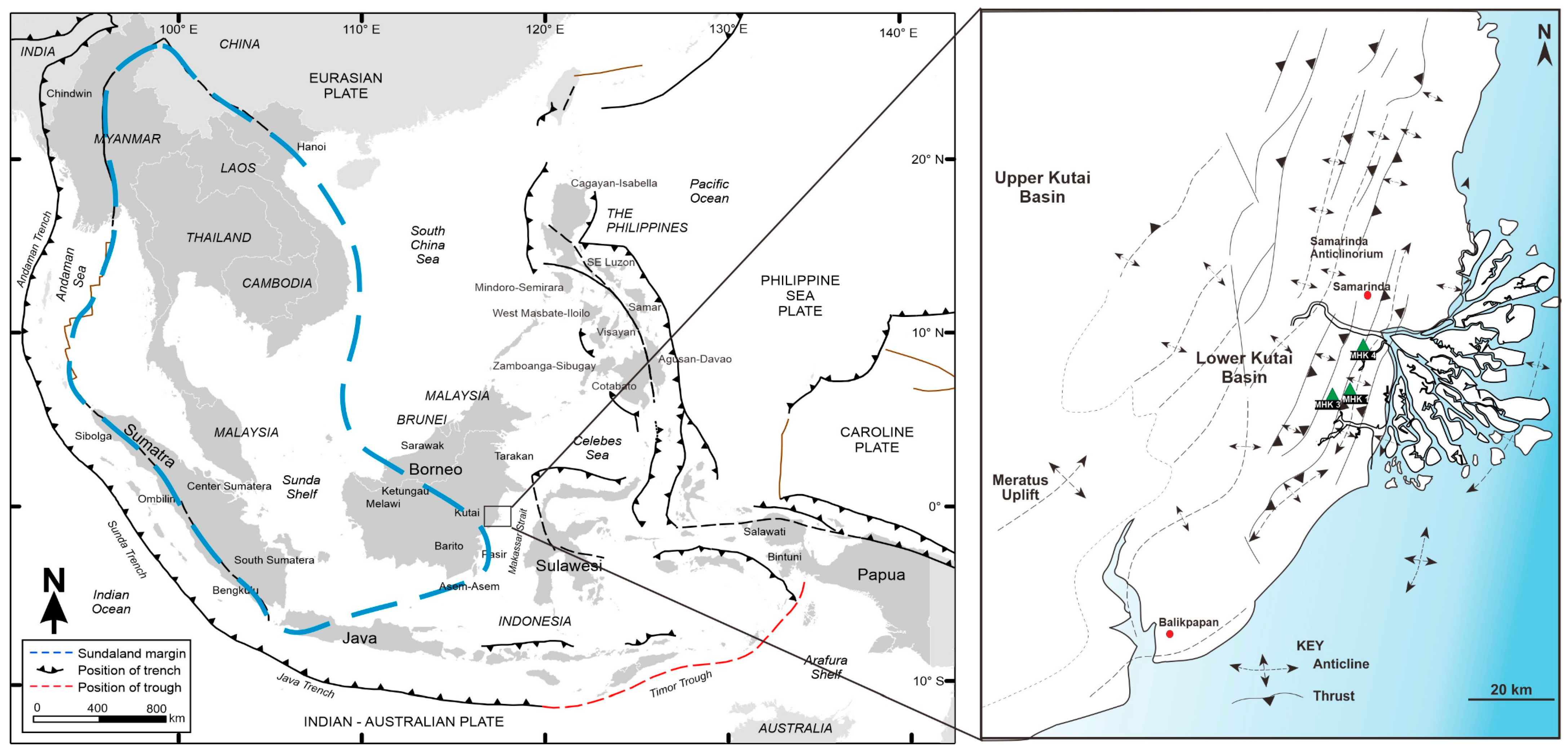
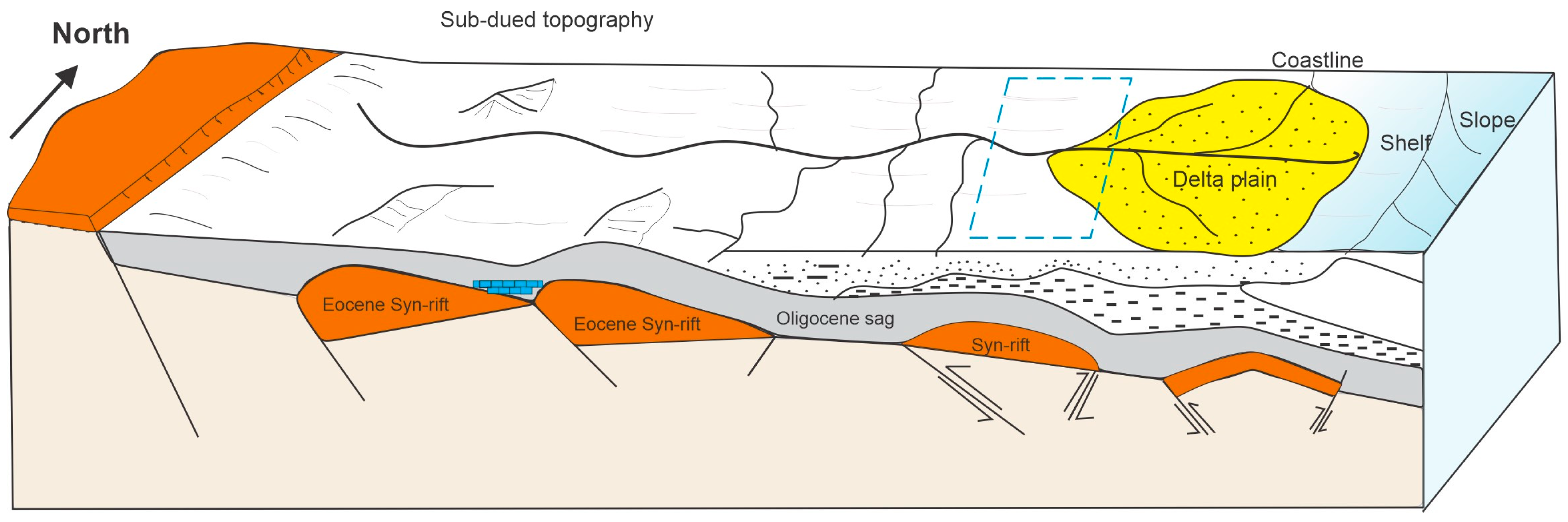
2. Geological Setting

The Cenozoic rift basins of Southeast Asia are situated in the Sundaland region, which encompasses much of present-day Indochina, Thailand, and western Indonesia (Figure 1). The countries in the Sundaland region have proved to be rich producers of oil and gas. The Lower Kutai Basin together with the Upper Kutai Basin (located further west) form the largest Cenozoic basin in Indonesia [32]. The recent Mahakam Delta is located along the eastern coast of Kalimantan, the Indonesian portion of the island of Borneo, approximately 50 km south of the equator. The tectono-stratigraphic history of the Kutai Basin was initially controlled by the complex and prolonged interaction of three plates, namely, the IndianAustralian Plate to the south, the Pacific Plate to the east, and the Eurasian Plate to the north. Essentially, there are three megasequences distinguished in the basin, namely, the syn-rift, post-rift, and syn-inversion phases, produced from the Eocene to the Late Miocene [33,34,35,36,37].
The Kutai Basin was formed during an extension that also resulted in the opening of the northern Makassar Strait and the Sulawesi Sea during the Middle Eocene. Later, a series of half-grabens formed in the Late Eocene during a subsequent regional extensional phase. In the Middle to Late Eocene, the resulting half-grabens were rapidly filled by syn-rift deposits. The final phase of basin evolution, an inversion, occurred in the Early Miocene and resulted in an uplift of the centre of the basin, leading to shallow-marine deposition in the basin. The basin inversion continued and affected mainly the eastern Lower Kutai Basin also during the Middle Miocene and Pliocene, further accelerating the process of delta progradation [38]. Presently, the Mahakam Delta forms the main active depocenter in the Lower Kutai Basin. In the Middle Miocene, when uplift was moving eastward, the Mahakam River incised the Samarinda anticlinorium and could not move laterally [38]. Thus, successive deltas have prograded from a single point source near the current head of the passes.
The paleodepositional environment of the Lower Kutai Basin has been compared to the modern delta [38,39,40,41,42,43,44]. The research area contains several oil and gas fields, where a combination of structure and stratigraphy is the dominant trapping mechanism. The study area is located in the Sanga-Sanga block of East Kalimantan and is mostly dominated by deltaicsediments of the Miocene age [42,45]. The structural setting of the studied region comprises double plunging anticlines and synclines bounded by thrust faults to the west and the east (Figure 2).
The Miocene sediments of the Lower Kutai Basin are divided into several lithostratigraphic units (Figure 3). The Middle Miocene to Pliocene Kampung Baru Group consists of the deltaic Tanjung Batu Formation to the west and the marine Sepinggan Formation to the east. The Middle Miocene Balikpapan Group includes the marine Gelingseh Formation’s upper carbonate to marine clastic Klandasan Tongue and the paralic-deltaic beds of the Mentawir Formation, respectively. The hydrocarbon-rich sandstone units are stratigraphically associated with the Mentawir and the Gelingseh Formation of the Balikpapan Group. The Lower Miocene Bebulu Group consists of the Maruat Formation and Pulau Balang Formation. These groups and their subdivisions are described at their type and reference localities [38,47,48,49].

3. Data and Methodology

The interpretation of the depositional environment and paleoclimate of the studied Middle Miocene Balikpapan Group succession benefited from a combined approach using electrofacies and mineralogical analysis. All 40 samples used in this study are cutting samples and were taken from the Mentawir Formation within a depth interval of 57 to 505 m in well MKH3. These samples were used for mineralogical analysis, mainly for clay mineralogy. The compositional and mineralogical examinations were evaluated using scanning electron microscopy (SEM-EDS) and X-ray diffraction (XRD) at the Department of Geology, University of Vienna (Austria). The gamma ray logs from three available wells, MHK1, MHK3, and MHK4 (Figure 4), led to the identification of characteristic facies types.

3.1. X-ray Diffraction (XRD)

Forty cutting samples of shale in well MHK3 were studied to identify the main mineralogical composition using X-ray diffraction (XRD) analysis. The mineralogical study of the samples by X-ray diffraction was conducted in two phases: the first one determined the mineralogy of the powdered bulk sample and the second phase focused on the study of the <2 µm fraction of the samples to analyze the clay fraction. Mineralogical composition was determined using X-ray powder diffraction (XRD) using a Panalytical PW 3040/60 X’Pert Pro X-ray diffractometer (CuK radiation, 40 kV, 40 mA, step size 0.0167, 5 s for each step).
For clay mineralogy investigation, samples were first disaggregated with diluted H2O2 to eliminate organic material, then treated with a 400 W ultrasonic probe for 3 min. Given that clay minerals have a grain size of less than 2 µm, an Atterberg cylinder settling method was used to separate the clay size fraction (24 h 33 min), which was dried at 60 °C. Oriented clay samples were made by pipetting suspensions (10 mg of sample in 1 mL of distilled water) onto glass slides and allowing them to air-dry. After analyzing oriented XRD mounts saturated with Mg and K ions, the samples were saturated with ethylene glycol (EG) and glycerol (Gly) at 60 °C for 12 h to detect expandable clay minerals such as smectite and vermiculite. In addition, the samples were heated to 550 degrees Celsius to destroy kaolinite and expandable clay minerals [50,51,52].

3.2. Scanning Electron Microscopy (SEM)

Ten cutting samples originating from well MHK3 were prepared for the SEM analysis and then coated with a thin carbon layer in order to obtain a conductive surface. SEM and EBSD used an Inspect S-50 instrument at the University of Vienna (Austria), operated at a 12.50 kV accelerating voltage.

3.3. Electrofacies Analysis

The electrofacies approach was developed and used for discriminating the depositional environment of facies in the subsurface by using gamma ray (GR) well log responses [53,54,55,56]. The systematic application of logs is widely used in hydrocarbon-related sedimentological studies [57,58,59,60]. Gamma ray logs measure the natural radioactivity component of the respective formation in American Petroleum Institute(API) values. The scale of the gamma ray log ranges from 0–150 API, where high API values indicate shale and low values indicate sand. Thus, deflections of the gamma ray log to the right and left are generally interpreted as shaly and sandy formations, respectively. In general, GR patterns include cylindrical, funnel, bell, bow, and irregular shapes [61].

4. Results

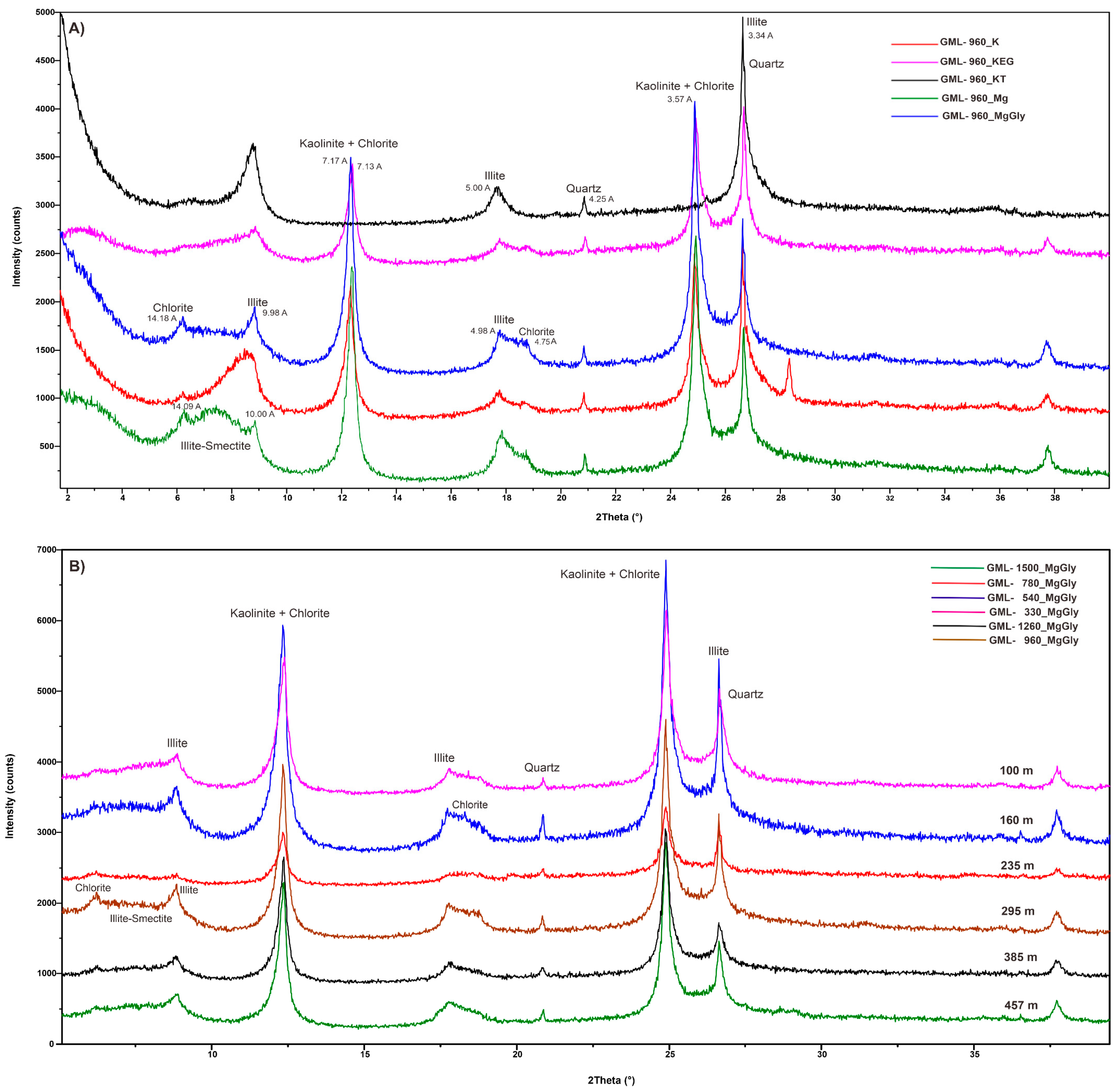
4.1. Bulk Mineralogy

The mineralogical composition of the 40 XRD samples from the Balikpapan Group indicate high contents of quartz and clay minerals (kaolinite, illite) (Figure 5). The samples contain very small to small amounts of muscovite, hematite, oxides (goethite), dolomite, siderite, and pyrite (0%–1%). Higher kaolinite contents in coal samples from the study area are associated with the acidic conditions of the coal-forming environment and mainly comprise syngenetic minerals. Illite is commonly found in coal interbedded with shallow marine sediments andfrequently occurring quartz is also syngenetic. Other minerals, such as siderite, can also form well in the final syngenetic phase and can be considered primary carbonates if they form under reducing conditions.

4.2. Clay Mineralogy (<2 μm Fraction)

Clay mineral distribution is controlled by sedimentary environments, burial history, and provenance lithologies. Kaolinite and mixed-layer illite/smectite (I/S) are the most abundant clay minerals encountered in the studied Mentawir Formation (Figure 6A). XRD results of the sample GML 960 at a depth 295 m indicate that the sample contains illite/smectite, kaolinite, illite, and chlorite (Figure 6A). Illite is identified by its 10 Å, 4.98 Å peaks. Chlorite is identified by its 14.18 Å, 7.13 Å, and 3.57 Å peaks, while kaolinite is identified by characteristic peaks of 7.17 Å and 3.57 Å. The I/S minerals also are identified by peaks between 10 Å and 14.09 Å, depending on the treatment. Based on clay mineral analysis of six cutting samples from depths of 100 m, 160 m, 235 m, 295 m, 385 m, and 457 m, all samples have a uniform clay mineral composition consisting of mixed-layer illite/smectite (I/S), kaolinite, illite, and chlorite (Figure 6B). Based on clay mineral analysis, kaolinite is the most common clay mineral in the studied section, composing around 38%–67%, followed by illite (14%–29%), chlorite (2%–17%), and mixed-layer illite/smectite (I/S) (14%–30%).

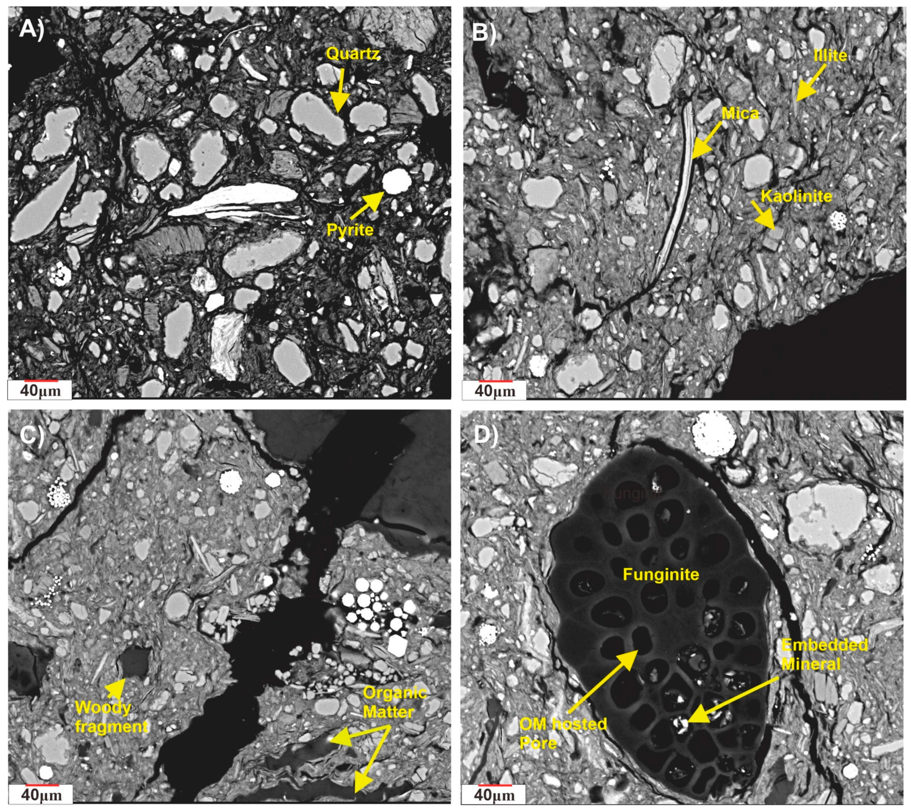
4.3. Scanning Electron Microscopy (SEM)

Quartz, fragments of lithic material, feldspars, micas, and clay minerals represent the most common grains found in the samples. As expected, pyrite is detected in organic-rich, fine-grained sediments deposited in the frontal zone of the delta. It typically occurs as either framboidal or euhedral crystal or masses with framboids are formed due to an abundance of carbonaceous matter intimately mixed with detrital iron and preserved under a strongly anoxic stratified water column (Figure 7A,B). Only a few of the samples have been examined and found to contain terrigenous woody organic particles, also known as type III kerogen. They have a distinct compaction-resistant structured shape with arcuate edges which allows them to be easily distinguished (Figure 7C). The Marcellus organic matter type and its possible influence on organic matter-hosted pore systems are intriguing. Small-scale spatial heterogeneity in organic matter-hosted porosity (Figure 7D) has been observed at the nanometer to micrometre scale in previous studies.

4.4. Electrofacies Pattern

Studies of sedimentary environments in the Balikpapan Group revealed that vertical profiles of grain size from a specific environment have certain log characteristics. In this study, gamma ray logs were used to identify lithologies and to correlate zones between the wells (Figure 8). The sediments of the Balikpapan Group, examined in three wells. MHK 1, MHK 3, and MHK 4, consist of interbedded coal with siltstone, claystone, and sandstone. The type of lithology found in well MHK 1 and well MHK 3 is very similar because the distance between the two wells is 200 m. Both wells are dominated by shale lithology, while well MHK 4, 17 km away from the two other wells, is dominated by sandstone. Four different gamma ray log shapes were identified in the Balikpapan Group: funnel-, bell-, cylindrical-, and bow-shaped patterns. These patterns are indicative of distinctive lithologies, which are associated with certain depositional environments. The vertical changes in the well logs can reflect changes in relative sea-level (e.g., short-term oscillations causing a seaward or landward shift of the depositional environment over time) as well as tectonic subsidence and minimaluplift.
The funnel shape is interpreted as a coarsening upward sequence with sandstones dominating at the top. The sediments in the Balikpapan Group, having the above trends, are suggested to be deposited in progradational settings. The funnel shape further indicates an increasing hydrodynamic energy condition upward [53,62], thus supporting the preservation of organic matter during rapid sedimentation with minimal alteration and oxidation [53]. The bell-shaped log facies in the Balikpapan Group can be interpreted as a fining-upward sequence with fine-grained facies (siltstone and claystone) at the top. The bell shape reflects a retrogradational trend with depositional energy decreasing upwards. A cylindrical shape indicates a sand-dominated, shale-free sequence with sharp upper and lower contacts [53]. Depositional energy is essentially constant, indicating an aggradational pattern of fluvial channels, deltaic distributaries, and tidal sands. It could also point to a slope and fan channel environment [63]; however, this interpretation is not favored here. The least occurring bow shape is defined as a cleaning-upward trend overlaid by a dirtying-upward trend [53]. Medium- to coarse-grained sandstone is overlain and underlain by fine-grained sediments (e.g., claystone). The shape is interpreted to reflect the lower front delta environment.

5. Discussion

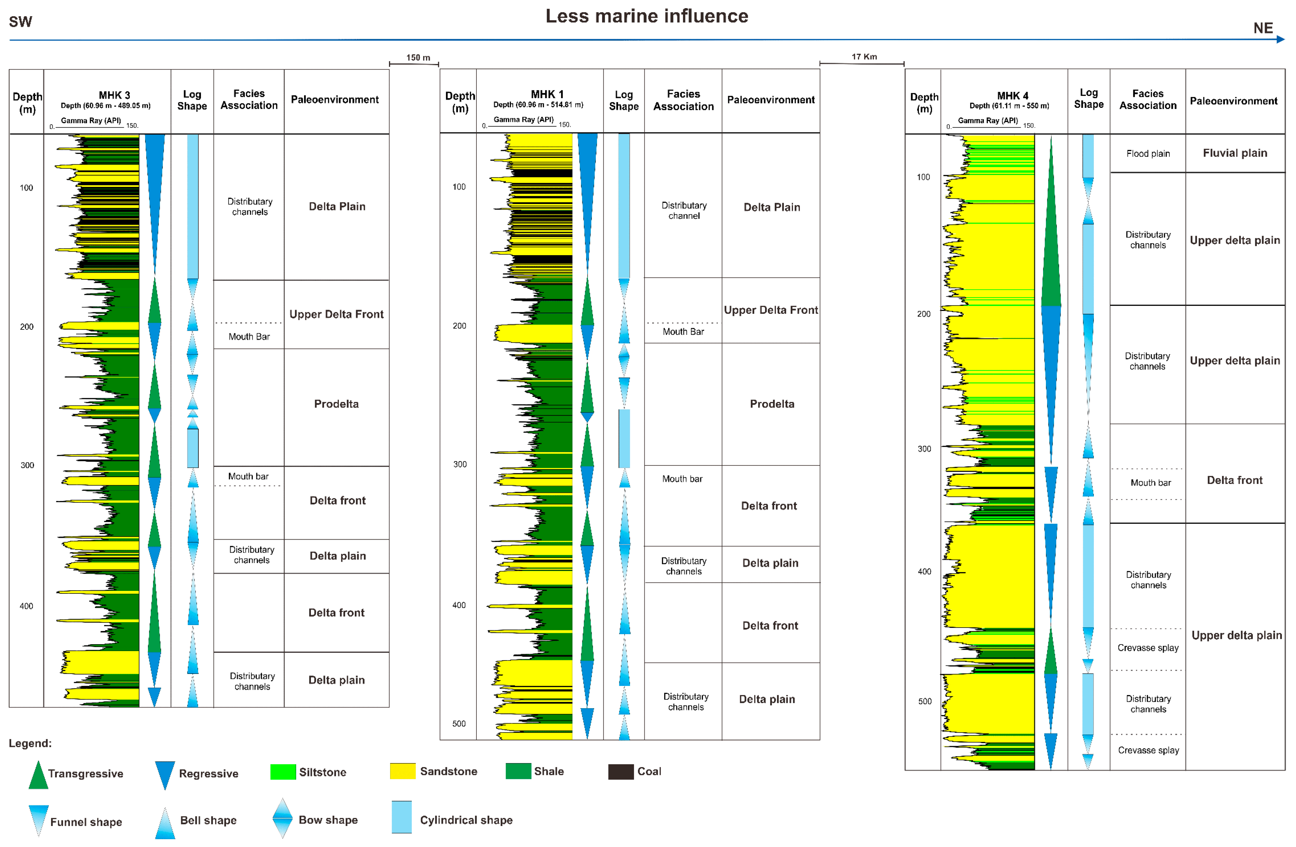
5.1. Depositional Environment

The modern Mahakam delta is regarded as a tidalfluvial-dominated delta system [43,64]. The delta system prograded to its current position during the Middle Miocene, depositing over 4 km of shallow marine and fluvial sediments [44,46]. Based on sample composition and mineralogical and gamma ray log analyses, the depositional environment is interpreted to have formed part of the fluvio-deltaic system during the Middle Miocene (Figure 9).
In the wells used in this study, prodelta fine-grained facies, delta front sandy-shale facies, and delta plain sandstone facies were identified. As previously mentioned, wells MHK 1 and MHK 3 in the southwest have higher proportions of fine-grained facies, which are interpreted as reflecting deposition along the delta front or in the area of the prodelta. The sandstones are generally thinner than in well MHK 4 and are divided into two groups. Thin sandstones, located in the central part of the logs, diplay coarsening upwards and are often isolated within fine-grained facies (Figure 8). These sandstones are interpreted as representing mouth bar deposits in the delta front area. Thicker sandstone beds, which are present in the upper and lowermost parts of wells MHK 1 and 3, are commonly interbedded with coal layers and show various degrees of amalgamation. These are interpreted as deposits of distributary channel on a delta plain.
In contrast, well MHK4 is almost entirely composed of amalgamated sandstones with funnel, bell, and cylindrical shapes in the gamma ray log (Figure 8). Sandstones are much thicker than in the two other wells and are only locally interbedded with thin layers of siltstones and coal. Thick amalgamated sandstones, interpreted as deposited in distributary channels, are intercalated with three fine-grained units that contain thinly bedded sandstones. The two lower units are interpreted as reflecting deposition in the inter-distributary area on the delta plain, with thin sandstones probably representing crevasse splay deposits. The fine-grained unit in the centre of the well is interpreted to reflect a delta front with sandy mouth bar deposits (Figure 8).
The research area is typified by high sediment input and rapid sedimentation, as well as by rapid sea level oscillations, indicated by the alternations of sandstone and claystone lithologies in the area. Following the inversion tectonic event at the end of the Early Miocene, a large amount of sediment prograded eastward from the newly formed Samarinda anticlinorium into the Makassar Strait, where the rate of increase in accommodation appears to have largely matched the rate of sediment input up to the present to form the active Mahakam Delta [38,40,65]. The fluvio-deltaic system had a single point of entry for sediment supply and, due to the ongoing basin inversion, most probably also had a relatively steep gradient. Based on these assumptions, it is proposed here that sediments in well MHK 4 reflect deposition in the upper part of the system, while wells MHK 1 and 3 could represent lower sections of the fluvio-deltaic system. Interestingly, the amount of coal layers is significantly higher in wells MHK 1 and 3, indicating existence of peat, mire conditions, or extensive standing pools of water in the low-lying area, where the lateral dispersal of sediments was possible. In contrast, the higher-lying region, as exemplified by well MHK 4, is characterized by sand-dominated deposition and thick amalgamated channel bodies with relatively poorly preserved fine-grained floodplain/delta plain deposits, pointing to vertical stacking with limited lateral depositional extent. The Mahakam distributaries appear to indicate the existence of a downstream facies change, with clean sand facies predominating in the upstream zone of the delta plain and muddier and thinner-bedded mouth bar sand facies in the downstream zone (Figure 9).
In addition, an abrupt vertical facies shift in wells MHK 1 and 3 from the distributary channel unit to the delta front and prodelta succession, and up to the distributary channels again, suggests an initial relative low sea level followed by a relative sea level rise and later by a sea level fall. A similar pattern is observed in well MHK 4, where thick distributary channels and their amalgamation imply marine regression, whereas deposition of mouth bar sediment encountered in the central part of the log point to the relative sea-level rise and deposition of more fine-grained material above the fluvio-deltaic sands. Well log analysis thus revealed that delta plain deposits predominate in the basal part of the logs. The central part is characterized by marine transgression and probably maximum flooding surface because the delta plain environment was vertically replaced by delta front and prodelta settings in the entire study area. The uppermost section of the logs reflects the return of delta and the fluvial plain environment, with distributary channels implying a marine regression. The sandiest section was probably deposited during lowstand and early transgressive periods, exemplified by a high degree of channel amalgamation and also the development of swamps in the near-coast area.

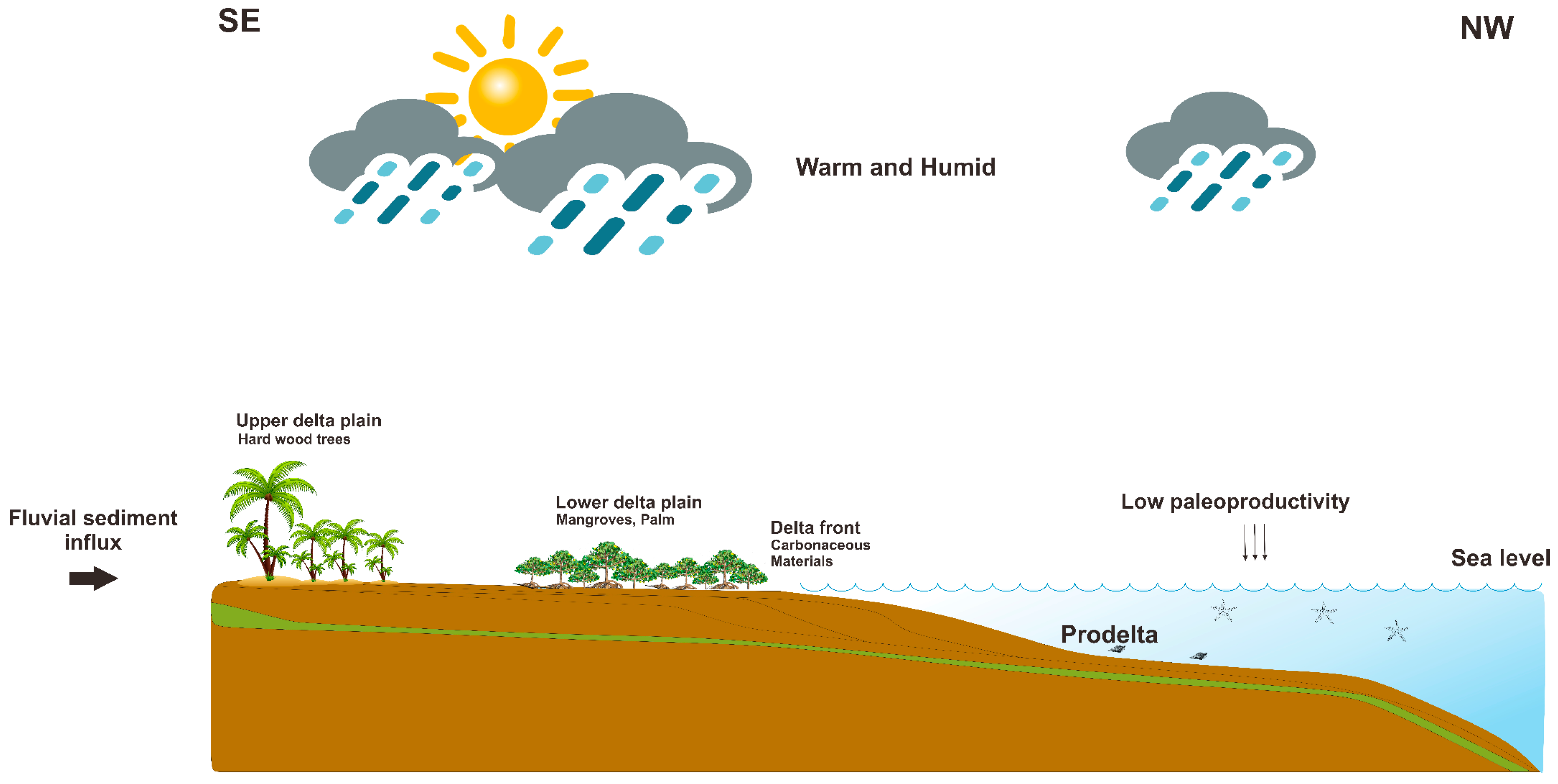
5.2. Paleoclimatic Conditions

The climate is considered to be a major determinant of organic matter input. A warm and humid climate is suitable for terrestrial plant growth, a mineral nutrient supply, and marine phytoplankton growth [19,66]. Using clay minerals in marine sediments, paleoclimatic conditions in the hinterland can be estimated [67,68,69]. The clay mineralogy in the Mahakam Delta indicates that the clay fraction is made up of mixed-layer illite/smectite, kaolinite, detrital illite, and chlorite. Mixed I/S clay minerals are the intermediate minerals for the transformation of smectite to illite. Four main genetic hypotheses for the origin of smectite and the mixed layer (I/S) exist: (1) reworking of soils and enrichment by differential settling, (2) alteration of volcanic material, (3) transformation of detrital minerals, and (4) authigenesis [70]. The majority of the K-feldspar alteration for both the shale and sandstone samples can be found in the Balikpapan Group. During the dissolution of K-feldspar and the upward migration of K, dickite particles likely grew in deeper intervals of the studied sequence, in contact with decarboxylated organic matter-acidified brines, while K-feldspar dissolved. Crystallization of these early kaolinite grains may have been aided by the migration of meteoric waters at some point in geologic history. This is interpreted to result from warm, humid conditions in a position near the equator since the Miocene (Figure 10). This area is classified today as type Af (tropical rainforest) with a minimum temperature of 18 °C and precipitation of 60 mm in the driest month of a normal year [71,72].
The paleoclimate of southeast Asia was more humid during the Middle Miocene due to the reported widespread expansion of rain forests [73]. A warmhumid paleoclimate was beneficial for organic sources, which were mainly aquatic algae and occasionally higher plants. A warmhumid paleoclimate with moderate paleosalinity and high fluvial nutrient input was also favorable for blooms of aquatic algae. The transformation of granitic and basic rocks into kaolinite takes place during the process of weathering. The Miocene weathering and subsequent leaching of the kaolinite from these rocks in the source regions was primarily responsible for its presence in the samples from the Mentawir Formation of the Balikpapan Group. In addition to the potential sediment supply from an antecedent stream, there may have been paleoclimate-related variations in the fluvial sediment supply to the Mahakam Delta. Similar climate changes have been suggested by other workers throughout the region [74]. Within the Middle Miocene, indicators of seasonality are also of limited occurrence, but short-lived acmes of conifer pollen suggest intermittent periods of cooler climate at times of low sea level [75]; some authors proposed that a climate that was drier and more seasonal may have been responsible for periods of woodland development and increased sediment supply.
The organic-rich sediments of the Balikpapan Group were deposited during the Miocene in a hot and humid climate. These paleoclimate conditions contributed to the preservation of organic matter as a result of the basin’s abundant terrestrial higher plant material production (Figure 11). Paleoclimate reconstructions and chronostratigraphic correlations indicate that deposition began in the latest Early Miocene and culminated during the Middle Miocene Climatic Optimum (MMCO) [44,76,77]. During the following global sea-level fall at 13.8 Ma, the delta mainly prograded and estimate the end-MMCO sea-level fall at 40–60 m, which would have driven or helped to establish a strong progradational delta succession and the change from a marine-influenced delta-front to more brackish to fluvial conditions.

5.3. Controlling Processes of Organic Matter Accumulation

Organic matter enrichment is a complicated geological processdominated by the interaction of various factors. The concentration of organic matter in fluvio-deltaic sediment is highly variable due to climatic and post-depositional exposure differences [78]. Terrestrial organic matter dominates marine or aquatic organic matter in such fluvial and deltaic sequences [79,80]. The accumulation and preservation of organic matter in the proximal delta is relatively higher than in the distal facies, and consists primarily of vegetal debris organic matter, such as wood and leaves, associated with thick-bedded shales and coal seams [25,32]. This variation in organic matter concentration is associated with the process of organic matter accumulation in recent sediments of the Mahakam Delta, which have a significantly higher organic matter content in the shallowest settings than in the outer offshore area [40]. Sedimentary organic matter corresponds to organic material directly or material indirectly derived from living organisms [81,82]. Quantity and quality in sediments are primarily the result of the interaction between biomass productivity, biochemical degradation, and organic matter deposition processes [82]. Organic matter is abundant along continental margins due to the high primary productivity of coastal waters and/or a high input of allochthonous land-derived terrestrial material. In fully marine environments, marine phytoplankton is the primary source of organic matter, whereas in certain shallow waters, marine phytobenthos is the primary source if sufficient light for photosynthesis is present [82]. Different environments have different degradational indices and biological origins for their entombed organic particles, and that assemblage of organic particles can indicate the depositional environment. Organic matter distribution and composition in delta channels, delta plain, subtidal platform, and delta front deposits reflects tide-influenced sedimentary processes. The accumulation of organic material in the Miocene Balikpapan Group is generally associated with coaly shales and coal in the environment of the delta plain, where organic material is generally of terrestrial origin. In the research area, the hydrocarbon source rock was derived from coal during the Miocene era and carbonaceous shale which was deposited in the fluvial delta-plain to delta-front environment (Figure 11). The Middle Miocene deposits accumulated in a deltaic environment largely similar to the modern Mahakam Delta and were covered by alluvial deposits. In such a deltaic sequence, the majority of organic matter is made up of higher land plants that are deposited close to but not precisely at the site of plant growth [83].
Organic-rich sediments from the Miocene indicate that the possible source rocks are delta plaindelta front coals and shales containing predominately type III kerogen organic matter. Delta front deposits are mostly black, organic-rich mud with plant fragments and silt laminae. Sulfur and siderite nodules indicate anoxic conditions in these sediments. Sediments from the Mahakam Delta plain are a mixture of muds and rare to abundant plant material (mangrove swamp, Nypa swamp, and transitional forest). The upper delta plain rainforest may also supply sedimentary organic matter. Sedimentary organic matter can be accounted for by the incorporation of produced leaves into waterways through direct leaf failure, slumping of channel banks, and sporadic tidal export. The plants in the lower delta plain make a dense, tangled web of dead Nypa palm petioles, leaves, and aerial roots [35,39,49]. Sedimentary organic matter in Mahakam deltaic environments comes mainly from delta plain vegetation. Organic matter from the delta plain, mostly degraded plant remains, is incorporated into the deltaic system by tidal channel erosion of Nypa and transitional forest. Vegetal debris such as wood and leaves accumulated in situ and was preserved by sedimentation, forming thick-layer coaly shales and coal beds.
SEM analysis used a polished block of sample GML 600 (depth 185 m) from well MHK 3. Samples from the Balikpapan Group are enriched in pyrite present in abundance in the forms of euhedral, framboidal pyrite and other concretions of a relatively large size for sedimentary pyrite (Figure 12). The percentages of pyritized phytoclasts indicate the environmental conditions in which pyrite crystals contaminate sedimentary organic matter in the delta system. However, pyrite and quartz have a strong correlation with the occurrence of coal facies in delta plain environments. Pyrite is also present owing to sulfate-reducing bacterial action in a reducing environment in which the organic matter (mangrove type) is easily preserved. In the mouth bars of the delta front, the confinement of the sedimentary environment creates reducing conditions where the organic matter again loses its molecular oxygen while the sulfate reducing microorganisms cause the formation of hydrogen sulfide. The large content of pyrite in the sediments indicates the intense mobilization of free sulfur by iron, which could explain the relatively low sulfur content of the oil in this area. The varied thin shapes of kaolinitic clay minerals under the SEM with embayed edges suggest that chemical weathering was stronger than physical weathering.
The diagenetic processes affecting organic matter are mediated by microorganisms, such as sulfate-reducing bacteria. Their activity contributes to the formation of framboidal pyrite crystals, resulting in the pyritization of organic matter [84,85]. The percentage of pyrite-infested phytoclasts is interpreted here as a measure of the sediment’s pyritization. However, crystals of pyrite were observed dispersed among organic particles on the surface of fragments of cuticle, or formed within pollen, fungal hyphae, microform lining, etc. Delta front and prodelta sediments have decreasing TOC values, sedimentation rates, and organic matter that has been pyritized. In sediments with less organic matter, the supply of metabolizable organic matter restricts pyritization and sulphate reduction. In marine siliciclastic sediments, slower mud deposition increases pyritization [86]. Pyrite-contaminated organic matter is rare to common in lower delta plain sediments.

6. Conclusions

Results of this study suggest that the depositional environment and paleoclimate control of Middle Miocene sediments are highly relevant for evaluation of the hydrocarbon potential in the Lower Kutai Basin, Indonesia. Kaolinite, illite, chlorite, and mixed illite-smectite layers form the main constituents of the Middle Miocene Mentawir Formation of the Balikpapan Group. Predominance of kaolinite (38%–67%) indicates that sediments of the studied formation were deposited during warm and humid climate conditions. Sediments of the studied interval were most likely deposited in a transitional fluvio-deltaic environment. The base level of the fluvial system that supplied sediment to the delta was controlled by sea-level oscillations, resulting in the deposition of transgressive-regressive vertical successions and also in lateral facies distribution along the fluvio-deltaic system. Under warm and humid climatic conditions, plankton was abundant, and organic matter supply was sufficient in the Middle Miocene Lower Kutai Basin. Most of the sedimentary organic matter in the Lower Kutai Basin is derived from the delta plain vegetation and is thus highly dominated by plant debris.

Author Contributions

Conceptualization, J.; methodology, K.S. and S.G.; validation, J., M.W. and S.G.; formal analysis, J.; investigation, J. and K.S.; data curation, J. and D.P.B.; writing—original draft preparation, J.; writing—review and editing, J., K.S., S.G. and M.W; visualization, J. and K.S.; Supervision, M.W. All authors have read and agreed to the published version of the manuscript.

Funding

This research was funded by the Ministry of Education and Culture of Indonesia and Austrian Agency for International Cooperation in Education and Research (OeAD GmbH): MPC-2020-01344. Open access was funded by the University of Vienna.

Data Availability Statement

Not applicable.

Acknowledgments

The authors acknowledge the state-owned enterprise for their permission in providing cutting rock samples to conduct this study. The authors thank the three anonymous reviewers who provided insightful comments that helped to improve this manuscript.

Conflicts of Interest

The authors declare no conflict of interest.

References

  1. Demaison, G.J.; Moore, G.T. Anoxic environments and oil source bed genesis. Org. Geochem. 1980, 2, 9–31. [Google Scholar] [CrossRef]
  2. Adepehin, E.J.; Ali, C.A.; Zakaria, A.A.; Sali, M.S. An overview of 20 years’ hydrocarbon exploration studies and findings in the Late Cretaceous-to-Tertiary onshore Central Sarawak, NW Borneo: 1997–2017 in retrospect. J. Pet. Explor. Prod. Technol. 2019, 9, 1593–1614. [Google Scholar] [CrossRef]
  3. Oudin, L.; Picard, P.F. Genesis of hydrocarbons in the Mahakam Delta and the relationship between their distribution and the overpressured zone. Indones. Pet. Assoc. 1982, 1, 181–202. [Google Scholar]
  4. Paterson, D.W.; Bachtiar, A.; Bates, J.A.; Moon, J.A.; Surdam, R.C. Petroleum system of the Kutei Basin, Kalimantan, Indonesia. In Proceedings of the International Conference on Petroleum Systems of SE Asia and Australasia, Jakarta, Indonesia, 21–23 May 1997; Indonesian Petroleum Association: Jakarta, Indonesia, 1997. [Google Scholar]
  5. Peters, K.E.; Snedden, J.W.; Sulaeman, A.; Sarg, J.F.; Enrico, R.J. A new geochemical-sequence stratigraphic model for the Mahakam Delta and Makassar Slope Kalimantan, Indonesia. Bull. Am. Assoc. Pet. Geol. 2000, 84, 12–44. [Google Scholar] [CrossRef]
  6. Bruenig, E.F. Oligotrophic forested wetlands in Borneo. In Forested Wetlands; Lugo, A.E., Ed.; U.S. Geological Survey: Riston, VA, USA, 1990; Volume 15, pp. 299–334. [Google Scholar]
  7. Pham Van, C.; de Brye, B.; Deleersnijder, E.; Hoitink, A.J.F.; Sassi, M.; Spinewine, B.; Hidayat, H.; Soares-Frazão, S. Simulations of the flow in the Mahakam river–lake–delta system, Indonesia. Environ. Fluid Mech. 2016, 16, 603–633. [Google Scholar] [CrossRef]
  8. Peters, K.E.; Cassa, M. Applied source rock geochemistry. In The Petroleum System from Source to Trap; AAPG Memoir: Tulsa, OK, USA, 1994; Volume 60, pp. 93–117. [Google Scholar] [CrossRef]
  9. Hunt, J.M. Petroleum Geochemistry and Geology; W. H. Freeman: New York, NY, USA, 1996; 743p. [Google Scholar]
  10. Jia, C.; Zheng, M.; Zhang, Y. Unconventional hydrocarbon resources in China and the prospect of exploration and development. Pet. Explor. Dev. 2012, 39, 129–136. [Google Scholar] [CrossRef]
  11. Jiang, Z.; Liang, C.; Wu, J.; Zhang, J.; Zhang, W.; Wang, Y.; Liu, H.; Chen, X. Several issues in sedimentological studies on hydrocarbon-bearing fine-grained sedimentary rocks. Acta Pet. Sin. 2013, 34, 1031–1039. [Google Scholar]
  12. Hu, S.; Zhu, R.; Wu, S.; Bai, B.; Yang, Z.; Cui, J. Exploration and development of continental tight oil in China. Pet. Explor. Dev. 2018, 45, 737–748. [Google Scholar] [CrossRef]
  13. Pedersen, T.F.; Calvert, S.E. Anoxia vs productivity: What controls the formation of organic-carbon rich sediments and sedimentary rocks. AAPG Bull. 1991, 74, 454–466. [Google Scholar]
  14. Paytan, A.; Griffith, E.M. Marine Barite: Recorder of Variations in Ocean export Productivity. Deep. Sea Res. Part II Top. Stud. Oceanogr. 2007, 54, 687–705. [Google Scholar] [CrossRef]
  15. Algeo, T.J.; Kuwahara, K.; Sano, H.; Bates, S.; Lyons, T.; Elswick, E. Spatial Variation in Sediment Fluxes, Redox Conditions, and Productivity in the Permian–Triassic Panthalassic Ocean. Palaeogeogr. Palaeoclimatol. Palaeoecol. 2011, 308, 65–83. [Google Scholar] [CrossRef]
  16. Hieronymus, B.; Kotschoubey, B.; Boulegue, J. Gallium behavior in some contrasting lateritic profiles from Cameroon and Brazil. J. Geochem. Explor. 2001, 72, 147–163. [Google Scholar] [CrossRef]
  17. Makeen, Y.M.; Hakimi, M.H.; Abdullah, W.H. The origin, type and preservation of organic matter of the Barremian—Aptian organic-rich shales in the Muglad Basin, Southern Sudan, and their relation to paleoenvironmental and paleoclimate conditions. Mar. Pet. Geol. 2015, 65, 187–197. [Google Scholar] [CrossRef]
  18. Ayinla, H.A.; Abdullah, W.H.; Makeen, Y.M. Source rock characteristics, depositional setting and hydrocarbon generation potential of cretaceous coals and organic rich mudstones from Gombe Formation, Gongola Sub-basin, Northern Benue Trough. NE Nigeria. Int. J. Coal Geol. 2017, 173, 212–226. [Google Scholar] [CrossRef]
  19. Chamley, H. Clay Sedimentology; Springer: Berlin/Heidelberg, Germany, 1989. [Google Scholar] [CrossRef]
  20. Churchman, G.J. The alteration and formation of soil minerals by weathering. In Handbook of Soil Science; Summer, M.E., Ed.; CRC Press: New York, NY, USA, 2000; Volume 1, pp. 3–27. [Google Scholar]
  21. Peters, K.E.; Fowler, M.G. Applications of petroleum geochemistry to exploration and reservoir management. Org. Geochem. 2002, 33, 5–36. [Google Scholar] [CrossRef]
  22. Bachtiar, A.; Heru, N.D.W.; Azzaino, Z.; Utomo, W.; Krisyunianto, A.; Sani, M. Surface data re-evaluation, Eocene source rock potential and hydrocarbon seepage, and Eocene sand reservoir prospectivity in West Sangatta, Northern Kutai Basin. In Proceedings of the Indonesian Petroleum Association, 37th Annual Convention and Exhibition, Jakarta, Indonesia, 15–17 May 2013; Indonesian Petroleum Association: Jakarta, Indonesia, 2013. [Google Scholar]
  23. Permana, A.K.; Sendjadja, Y.A.; Panggabean, H.; Fauxely, L. Depositional Environment and Source Rocks Potential of the Miocene Organic-Rich Sediments, Balikpapan Formation, East Kutai Sub-Basin, Kalimantan. J. Geol. Miner. Resour. 2018, 9, 171–186. [Google Scholar]
  24. Lambert, B.; Duval, B.C.; Grosjean, Y.; Umar, I.M.; Zaugg, P. Impact of an Evolving Geological Model on the Dramatic Increase of Gas Reserves in the Mahakam Delta: The Peciko Case History; AAPG Memoir: Tulsa, OK, USA, 2003; Volume 78, pp. 297–320. [Google Scholar]
  25. O’Keefe, J.M.K.; Bechtel, A.; Christanis, K.; Dai, S.; DiMichele, W.A.; Eble, C.F.; Esterle, J.S.; Mastalerz, M.; Raymond, A.L.; Valentim, B.V.; et al. On the fundamental difference between coal rank and coal type. Int. J. Coal Geol. 2013, 118, 58–87. [Google Scholar] [CrossRef]
  26. Fowler, M.G.; Gentzis, T.; Goodarzi, F.; Foscolos, A.E. The petroleum potential of some Tertiary lignites from northern Greece as determined using pyrolysis and organic petrological techniques. Org. Geochem. 1991, 17, 805–826. [Google Scholar] [CrossRef]
  27. Sykes, R.; Snowdon, L.R. Guidelines for Assessing the Petroleum Potential of Coaly Source Rocks Using Rock-Eval Pyrolysis. Org. Geochem. 2002, 33, 1441–1455. [Google Scholar] [CrossRef]
  28. Petersen, H.I. The petroleum generation potential and effectiveoil window of humic coals related to coal composition and age. Int. J. Coal Geol. 2006, 67, 221–248. [Google Scholar] [CrossRef]
  29. Davis, R.C.; Noon, S.W.; Harrington, J. The petroleum potential of Tertiary coals from Western Indonesia: Relationship to mire type and sequence stratigraphic setting. Int. J. Coal Geol. 2007, 70, 35–52. [Google Scholar] [CrossRef]
  30. Duval, B.C.; Cassaigneau, C.; Choppin de Janvry, G. Impact of the petroleum system approach to exploration and appraisal efficiency in the Mahakam Delta. In Proceedings of the 26th Annual Convention, Jakarta, Indonesia, 18–20 May 1998; Indonesian Petroleum Association: Jakarta, Indonesia, 1998. [Google Scholar]
  31. Peters, K.E.; Snedden, J.W.; Sulaeman, A.; Sarg, J.F.; Enrico, R.J. New Deepwater Geochemical Model for the Mahakam Delta and Makassar Slope, Kalimantan. In Proceedings of the 27th Annual Convention and Exhibition, Jakarta, Indonesia, October 1999; Indonesian Petroleum Association: Jakarta, Indonesia, 1999. [Google Scholar]
  32. Permana, A.K.; Kusworo, A.; Wahyudiono, J.; Sendjaja, Y.A.; Panggabean, H.; Fauziely, L. Chemostratigraphy and Paleoenvironment of the Miocene Organic Rich Sediments in the East Kutai Sub-Basin, Indonesia. J. Geol. Dan Sumberd. Miner. 2022, 23, 1–15. [Google Scholar] [CrossRef]
  33. Cloke, I.R.; Moss, S.J.; Graig, J. Structural controls on the Evolution of the Kutai Basin, East Kalimantan. J. Asian Earth Sci. 1999, 17, 137–156. [Google Scholar] [CrossRef]
  34. Van de Weerd, A.A.; Armin, R.A. Origin and evolution of the Tertiary hydrocarbon bearing basins in Kalimantan Borneo, Indonesia. Am. Assoc. Petrol. Geol. Bull. 1992, 76, 1778–1803. [Google Scholar]
  35. Husein, S.; Lambiase, J.J. Sediment dynamics and depositional systems of the Mahakam Delta, Indonesia: Ongoing Delta abandonment on a tide-dominated coast. J. Sediment. Res. 2013, 83, 503–521. [Google Scholar]
  36. McClay, K.R.; Dooley, T.; Ferguson, A.; Poblet, J. Tectonic evolution of the Sanga Sanga block, Mahakam delta, Kalimantan, Indonesia. Am. Assoc. Petrol. Geol. Bull. 2000, 84, 765–786. [Google Scholar]
  37. Fikri, H.N.; Sachsenhofer, R.F.; Bechtel, A.; Gross, D. Organic geochemistry and petrography in Miocene coals in the Barito Basin (Tutupan Mine, Indonesia): Evidence for astronomic forcing in kerapah type peats. Int. J. Coal Geol. 2022, 256, 103997. [Google Scholar] [CrossRef]
  38. Allen, G.P.; Chamber, J.L.C. Sedimentation in the Modern and Miocene Mahakam Delta. In Proceedings of the 26th Annual Convention, Jakarta, Indonesia, 18–20 May 1998; Indonesian Petroleum Association: Jakarta, Indonesia, 1998. [Google Scholar]
  39. Magnier, P.; Oki, T.; Kartaadiputra, L. The Mahakam Delta, Kalimantan, Indonesie. In Proceedings of the 9th World Petroleum Congress, Tokyo, Japan, 11–16 May 1975. [Google Scholar]
  40. Allen, G.P.; Laurier, D.; Thouvenin, J.P. Sediment Distribution Patterns in the Modern Mahakam Delta. In Proceedings of the 5th Annual Convention, Jakarta, Indonesia, 7–8 June 1976; Indonesian Petroleum Association: Jakarta, Indonesia, 1976. [Google Scholar]
  41. Verdier, A.; Oki, T.; Suardy, A. Geology of the Handil Field (East Kalimantan—Indonesia). In Giant Oil and Gas Fields of the Decade 1968–1978; Halbouty, M.T., Ed.; American Association of Petroleum Geologist Memoir: Tulsa, OK, USA, 1980; Volume 30, pp. 399–421. [Google Scholar] [CrossRef]
  42. Moss, S.J.; Chambers, J.L. Tertiary facies architecture in the Kutai basin, Kalimantan, Indonesia. J. Asian Earth Sci. 1999, 17, 157–181. [Google Scholar] [CrossRef]
  43. Storms, J.E.A.; Hoogendoorn, R.M.; Dam, R.A.C.; Hoitink, A.J.F.; Kroonenberg, S.B. Late-Holocene evolution of the Mahakam delta, East Kalimantan, Indonesia. Sediment. Geol. 2005, 180, 149–166. [Google Scholar] [CrossRef]
  44. Marshall, N.; Novak, V.; Cibaj, I.; Krijgsman, W.; Renema, W.; Young, J.; Fraser, N.; Limbong, A.; Morley, R. Dating Borneo’s deltaic deluge: Middle Miocene progradation of the Mahakam Delta. Palaios 2015, 30, 7–25. [Google Scholar] [CrossRef]
  45. Riadi, R.S.; Lambiase, J.J. Outcrop Analogues for Subsurface Sand Body Geometries in Regressive and Transgressive Mahakam Delta Successions, Indonesian Petroleum Association. In Proceedings of the 39th Annual Convention, Jakarta, Indonesia, 20–22 May 2015; Indonesian Petroleum Association: Jakarta, Indonesia, 2015. [Google Scholar]
  46. Clauer, N.; Rinckenbach, T.; Weber, F.; Sommer, F.; Chaudhuri, S.; O’Neil, J.R. Diagenetic evolution of clay minerals in oil-bearing Neogene sandstones and associated shales, Mahakam Delta Basin, Indonesia. Am. Assoc. Petrol. Geol. Bull. 1999, 83, 62–87. [Google Scholar]
  47. Marks, E.B.; Sujatmiko, S.L.; Dhanutirto, H.; Ismoyowati, T.; Sidik, B. Cenozoic Stratigraphic Nomenclature in East Kutai Basin, Kalimantan. In Proceedings of the 11th Annual Convention Proceedings, Jakarta, Indonesia, June 1982; Indonesian Petroleum Association: Jakarta, Indonesia, 1982. [Google Scholar]
  48. Supriatna, S.; Rustandi, E. Peta Geology Lembar Samarinda; Pusat Penelitian dan Pengembangan Geologi: Bandung, Indonesia, 1986. [Google Scholar]
  49. Widodo, S.; Oschmann, W.; Bechtel, A.; Sachsenhofer, R.F.; Anggayana, K.; Puettmann, W. Distribution of sulfur and pyrite in coal seams from Kutai Basin (East Kalimantan, Indonesia): Implications for paleoenvironmental conditions. Int. J. Coal Geol. 2010, 81, 151–162. [Google Scholar] [CrossRef]
  50. Als-Nielsen, J.; McMorrow, D. Elements of Modern X-ray Physics, 2nd ed.; John Wiley and Sons Ltd.: Chichester, UK, 2011. [Google Scholar]
  51. Moore, D.M.; Reynolds, R.C. X-ray Diffraction and Identification and Analysis of Clay Minerals, 2nd ed.; Oxford University Press: New York, NY, USA, 1997. [Google Scholar]
  52. Gier, S. Clay mineral- and organic diagenesis of the Lower Oligocene Schöneck Fishshale, western Austrian Molasse Basin. Clay Miner. 2000, 35, 709–717. [Google Scholar] [CrossRef]
  53. Selley, R.C. Concepts and Methods of Subsurface Facies Analysis; American Association of Petroleum Geologists: Tulsa, OK, USA, 1978; pp. 9–82. [Google Scholar]
  54. Ghazi, S.; Mountney, N.P. Subsurface lithofacies analysis of the Fluvial Early Permian Warchha Sandstone, Potwar Basin, Pakistan. J. Geol. Soc. India 2010, 76, 505–517. [Google Scholar] [CrossRef]
  55. Siddiqui, N.A.; El-Ghali, M.A.; Bin Abd Rahman, A.H.; Mijinyawa, A.; Ben-Awuah, J. Depositional environment of shallow-marine Sandstones from outcrop gamma-ray logs, Belait Formation, Meragang Beach, Brunei Darussalam. Res. J. Environ. Earth Sci. 2013, 5, 305–324. [Google Scholar] [CrossRef]
  56. Nazeer, A.; Abbasi, S.A.; Solangi, S.H. Sedimentary facies interpretation of Gamma Ray (GR) log as basic well logs in Central and Lower Indus Basin of Pakistan. Geod. Geodyn. 2016, 7, 432–443. [Google Scholar] [CrossRef]
  57. Pirson, S.J. Handbook of Well Log Analysis for Oil and Gas Formation Evaluation; Schlumberger Limited: Houston, TX, USA, 1963. [Google Scholar]
  58. Serra, O. Sedimentary Environment from Wireline Logs; Schlumberger Educational Services: Houston, TX, USA, 1990. [Google Scholar]
  59. Posamentier, H.W.; Allen, G.P. Siliciclastic Sequence Stratigraphy: Concepts and Applications; SEPM (Society for Sedimentary Geology): Tulsa, OK, USA, 1999; Volume 7, p. 210. [Google Scholar]
  60. Baouche, R.; Sen, S.; Debiane, K.; Ganguli, S.S. Integrated reservoir characterization of the Paleozoic and Mesozoic sandstones of the El Ouar field, Algeria. J. Pet. Sci. Eng. 2020, 194, 107551. [Google Scholar] [CrossRef]
  61. Schmitt, P.; Veronez, M.R.; Tognoli, F.M.W.; Todt, V.; Lopes, R.C.; Silva, C.A.U. Electrofacies Modelling and Lithological Classification of Coals and Mud-Bearing Fine-Grained Siliciclastic Rocks Based on Neural Networks. Earth Sci. Res. 2012, 2, 193. [Google Scholar] [CrossRef]
  62. Cant, D.J. Subsurface Facies Analysis. In Facies Models: Response to Sea Level Change; Walker, R.G., James, N.P., Eds.; Geological Association of Canada: St. John’s, NL, Canada, 1992; pp. 27–45. [Google Scholar]
  63. Euzen, T.; Power, M.R. Well log cluster analysis and electrofacies classification: A probabilistic approach for integrating log with mineralogical data. Am. Assoc. Petrol. Geol. Search Discov. 2014. Available online: http://www.searchanddiscovery.com/documents/2014/41277euzen/ndx_euzen.pdf (accessed on 20 March 2023).
  64. Galloway, W.E. Process framework for describing the morphologic and stratigraphic evolution of deltaic depositional systems. In Deltas, Models for Exploration; Broussard, M.L., Ed.; Houston Geological Society: Houston, TX, USA, 1975; pp. 87–98. [Google Scholar]
  65. Cibaj, I.; Syarifuddin, N.; Ashari, U.; Wieko, A.; Maryunani, K. Stratigraphic Interpretation of Middle Miocene Mahakam Delta Deposits: Implications for Reservoir Distribution and Quality; Indonesian Petroleum Association: Jakarta, Indonesia, 2007. [Google Scholar]
  66. Talbot, M.R. The origins of lacustrine oil source rocks: Evidence from the lakes of tropical Africa. Geol. Soc. Lond. 1988, 40, 29–43. [Google Scholar] [CrossRef]
  67. Jeong, G.; Yoon, H. The origin of clay minerals in soils of King George Island, South Shetland Islands, West Antarctica, and its implications for the clay-mineral compositions of marine sediments. J. Sediment. Res. 2001, 71, 833–842. [Google Scholar] [CrossRef]
  68. Grim, R.E.; Allaway, W.H.; Cuthbert, F.L. Reaction of Different Clay Minerals with Some Organic Cations. J. Am. Ceram. Soc. 1947, 30, 137–145. [Google Scholar] [CrossRef]
  69. Brooks, B.T. Evidence of Catalytic Action in Petroleum Formation. Ind. Eng. Chem. 1952, 44, 2570–2577. [Google Scholar] [CrossRef]
  70. Thiry, M.; Jacquin, T. Clay mineral distribution related to rift activity, sea-level changes and paleoceanography in the Cretaceous of the Atlantic Ocean. Clay Miner. 1993, 28, 61–84. [Google Scholar] [CrossRef]
  71. Rubel, F.; Brugger, K.; Haslinger, K.; Auer, I. The climate of the European Alps: Shift of very high resolution Köppen-Geiger climate zones 1800–2100. Meteorol. Z. 2017, 26, 115–125. [Google Scholar] [CrossRef]
  72. Bunting, S.W.; Bosma, R.H.; van Zwieten, P.A.; Sidik, A.S. Bioeconomic modelling of shrimp aquaculture strategies for the Mahakam Delta, Indonesia. Aquac. Econ. Manag. 2013, 17, 51–70. [Google Scholar] [CrossRef]
  73. Morley, R.J. Origin and Evolution of Tropical Rain Forests; John Wiley and Sons Ltd.: Chichester, UK, 2000; p. 362. [Google Scholar]
  74. Anshari, G.; Kershaw, A.P.; Van der Kaars, S. A Late Pleistocene and Holocene pollen and charcoal record from peat swamp forest, Lake Sentarum Wildlife Reserve, West Kalimantan, Indonesia. Palaeogeogr. Palaeoclimatol. Palaeoecol. 2001, 171, 213–228. [Google Scholar] [CrossRef]
  75. Caratini, C.; Tissot, C. Paleogeographical evolution of the Mahakam Delta in Kalimantan, Indonesia during the Quaternary and Late Pliocene. Rev. Palaeobot. Palynol. 1988, 55, 217–228. [Google Scholar] [CrossRef]
  76. Zachos, J.; Dickens, G.; Zeebe, R. An early Cenozoic perspective on greenhouse warming and carbon-cycle dynamics. Nature 2008, 451, 279–283. [Google Scholar] [CrossRef]
  77. de Boer, B.; van de Wal, R.S.; Lourens, L.J.; Bintanja, R. Transient nature of the Earth’s climate and the implications for the interpretation of benthic δ18O records. Palaeogeogr. Palaeoclimatol. Palaeoecol. 2012, 335–336, 4–11. [Google Scholar] [CrossRef]
  78. Littke, R. Deposition, Diagenesis and, Weathering of Organic Matter-Rich Sediments; Springer: Berlin/Heidelberg, Germany, 1993; 216p. [Google Scholar]
  79. Scheidt, G.; Littke, R. Comparative organic petrology of interlayered sandstones, siltstones, mudstones and coals in the Upper Carboniferous Ruhr basin, northwest Germany, and their thermal history and methane generation. Geol. Rundsch. 1989, 78, 375–390. [Google Scholar] [CrossRef]
  80. Smyth, M. Organic petrology and clastic depositional environments with special reference to Australian coal basins. Int. J. Coal Geol. 1989, 17, 635–656. [Google Scholar] [CrossRef]
  81. Durand, B.; Nicaise, G. Procedures for kerogen isolation. In Kerogen—Insoluble Organic Matter from Sedimentary Rocks; Durand, B., Ed.; ETDE World Energy Base: Paris, France, 1980; pp. 35–53. [Google Scholar]
  82. Tissot, B.P.; Welte, D.H. Petroleum Formation and Occurrence, 2nd ed.; Springer: Berlin/Heidelberg, Germany, 1984. [Google Scholar]
  83. Scheihing, M.H.; Pfefferkorn, H.W. The taphonomy of landplants in the Orinoco delta: A model for the incorporation of plant parts in clastic sediments of Late Carboniferous age of Euramerica. Rev. Palaeobot. Palynol. 1984, 41, 205–240. [Google Scholar] [CrossRef]
  84. Jorgensen, B.B. Mineralization of organic matter in the sea bed: The role of sulphate reduction. Nature 1982, 296, 643–645. [Google Scholar] [CrossRef]
  85. Tanean, H.; Paterson, D.W.; Endharto, M. Source Provenance Interpretation of Kutei Basin Sandstones and Implications for Tectono-stratigraphic Evolution of Kalimantan; Indonesian Petroleum Association: Jakarta, Indonesia, 1996; pp. 333–345. [Google Scholar]
  86. Tyson, R.V. Sedimentary Organic Matter: Organic Facies and Palynofacies; Chapman & Hall: London, UK, 1995; p. 615. [Google Scholar]
Figure 1. The present-day tectonic elements of Southeast Asia (left) and the tectonic framework of the Lower Kutai Basin (right) (modified after [33,34,37]).
Minerals 13 01259 g001
Figure 2. Schematic model for the Middle Miocene to recent deltaic progradation post-inversion facies tract. The blue box indicates the study area. (Modified after [42,46]).
Minerals 13 01259 g002
Figure 3. Chronostratigraphic chart for the Lower Miocene to present-day Lower Kutai Basin. This study focused on the Mentawir Formation of the Balikpapan Group (indicated by the red box). The stratigraphy is based on [47].
Minerals 13 01259 g003
Figure 4. Map showing locations of sampling wells (MHK 1, 3, and 4) in the research area. The location of the Kutai Basin, East Kalimantan, Indonesia is shown in red colour in the subfigure (upper left).
Minerals 13 01259 g004
Figure 5. Bulk mineralogy of various Balikpapan Group samples from different depths in well MHK 3, namely, GML 330 (100 m), GML 540 (165 m), GML 780 (240 m), GML 960 (300 m), GML 1260 (385 m), and GML 1500 (460 m).
Minerals 13 01259 g005
Figure 6. (A) X-ray diffraction patterns of the clay fraction of sample GML 960 (well MHK 3) at the depth of 295 m saturated with Mg, K, Mg, and glycerol, and K and ethylene glycol and heated to 550 °C; (B) X-ray diffraction patterns of all MgGly saturated samples of the Balikpapan Group in well MHK 3.
Minerals 13 01259 g006
Figure 7. SEM images (backscattered electron images) of sample GML 600 (depth 185 m) from well MHK 3; (A) pyrite and quartz, clay minerals, and clay matrix; (B) platy euhedral kaolinite, fibrous illite, and mica, (C) woody organic matter (type III kerogen) and organic matter; (D) organic matter (Funginite)-hosted pores and embedded minerals (quartz).
Minerals 13 01259 g007
Figure 8. Gamma ray logs of wells MHK 1, 3, and 4 were used to reconstruct a regressivetransgressive cycle within fluvio-deltaic sediments of the Balikpapan Group.
Minerals 13 01259 g008
Figure 9. Schematic drawing showing fluvio-deltaic depositional environment of the research area based on the interpretation of gamma ray logs along the NE to SW-trending Sanga-Sanga Block. The wells include deposits of distributary channel, delta plain, mouth bar/delta front, and prodelta.
Minerals 13 01259 g009
Figure 10. Clay mineral composition of <2 μm fraction of the studied area including mixed layer illite-smectite (black line), illite (green line), kaolinite (red line), and chlorite (blue line). Lithological section is from well MHK 3.
Minerals 13 01259 g010
Figure 11. Schematic illustration showing the influence of paleoclimate, distribution, and transport on fluvio-deltaic sediments and organic matter in the Mahakam Delta.
Minerals 13 01259 g011
Figure 12. SEM image showing mineral composition and organic matter in sample MHK 3 (depth of 185 m): (A) Euhedral crystalline pyrite (pyt), I—Illite and K—Kaolinite; (B) Framboidal pyrite (pyt); (C,D) Different types of organic matter (Funginite). Organic matter contains pores filled with quartz.
Minerals 13 01259 g012
Disclaimer/Publisher’s Note: The statements, opinions and data contained in all publications are solely those of the individual author(s) and contributor(s) and not of MDPI and/or the editor(s). MDPI and/or the editor(s) disclaim responsibility for any injury to people or property resulting from any ideas, methods, instructions or products referred to in the content.

