Article

Features of Arsenic Distribution in the Soils of Potash Mines

Natural Science Institute, Perm State University, Genkel st.4, Perm 614068, Russia
*
Author to whom correspondence should be addressed.
Minerals 2022, 12(8), 1029; https://doi.org/10.3390/min12081029
Submission received: 15 July 2022 / Revised: 12 August 2022 / Accepted: 13 August 2022 / Published: 16 August 2022
(This article belongs to the Special Issue Environment and Geochemistry of Sediments)

Abstract

:
The purpose of the present study is to analyse the distribution of arsenic in the soils of the Verkhnekamskoe potassium salt deposit (Perm Krai, Russia). The danger of arsenic pollution is determined by its high toxicity and carcinogenic hazard. Being a technophilic element, arsenic enters the environment primarily as a result of mining activities. Mining and processing sites for arsenic-containing ores are the most prone to technophilic arsenic accumulation. Solid wastes from potash production also contain elevated concentrations of arsenic. The content of arsenic in soils was determined by inductively coupled plasma mass spectrometry (ICP-MS). Statistical methods were used to analyse the features of arsenic distribution in soils of background areas and potash mining areas near production facilities. Three types of landscapes were studied within each territory, which were each distinguished by the leading processes of substance migration. Arsenic concentrations in both the background areas and the potash mining territories vary considerably, ranging from n × 10−1 to n × 10. The study found no statistically significant differences in arsenic concentrations in soils of potash mining areas and background areas. Arsenic concentrations in soils from various types of landscapes also do not differ statistically. Arsenic concentrations in soils of saline areas were found to be higher than in the rest of the territories. Outside of saline areas, the identified patterns of arsenic distribution in the soils of the Verkhnekamskoe potassium salt deposit indicate that potash operations are not a determinant in the technophilic accumulation of arsenic.

1. Introduction

Mining areas have an increased geochemical technogenic load due to mining and processing. In the hypergenesis zone, primary minerals are transformed, and toxic elements and their compounds are released into the environment [1]. Studies of natural environment components’ contamination with toxic trace elements in mining-affected areas are of particular interest.
Arsenic is a chemical element of the first class of environmental hazard with high toxicity and carcinogenic properties that pose a serious risk to humans [2,3]. Arsenic can enter the human body through the consumption of arsenic-contaminated water or agricultural products grown on arsenic-contaminated soils. In India, Bangladesh, Nepal, China, Taiwan, Thailand, Argentina, Mexico, and other countries, arsenic contamination of groundwater used for drinking is a concern [3,4]. In this regard, effective methods for detecting [5] and removing arsenic from drinking water are being actively developed [6,7,8].
As a technophilic element, arsenic enters the environment primarily as a result of the mining and processing of minerals, where it is a major component in the ore or is present as an impurity as well as in the composition of pesticides used in agriculture. Arsenic compounds are found in small quantities in ores, hydrocarbon feedstocks, industrial clays, etc. During the mining and processing of minerals, arsenic is emitted into the atmosphere with inorganic pollutants, discharged into sewage, deposited in solid waste dumps, and washed out by atmospheric precipitation, polluting surface water and groundwater. Localised areas of ecologically hazardous pollution are formed as a result of arsenic distribution in the natural environment [9].
The assessment of arsenic contamination of soils in mining areas has received a lot of attention in China, which holds 70% of the world’s arsenic reserves [10]. Arsenic concentrations of up to 76,400 mg/kg with an average concentration of 1205.97 mg/kg have been found in soils near waste sites of mining and processing of arsenic-containing ore in Yunnan province, southwest China [10].
Negative environmental impacts, such as increased concentrations of a variety of trace elements in the natural environment, can also occur after mining has ceased, e.g., as a result of tailings material dispersion into the natural environment [11], or a lack of mothballing of abandoned mining sites [12]. The following elements dominate in the geochemical series in the surface element concentrations within the areas affected by the Dalnegorsk and Krasnorechensk tailings (Dalnegorsk district, Primorsky Krai, Russia): manganese, zinc, and arsenic; zinc, manganese, lead, and arsenic, respectively [11]. Arsenic and other trace element concentrations in mining wastes reach levels that classify tailings sites as technogenic deposits. The arsenic content in tailings of tin ore deposits in the Kavalerovsky region (Primorsky Krai, Russia) reaches 0.01–0.05% [12]. Arsenic has the highest concentrations in technogenic soils of tailings among toxic elements and exceeds average concentrations in the earth’s crust by 20–886 times in gold ore tailings, 152–5340 times in polymetallic tailings, and 1.2–172 times in rare-metal tailings [13].
Pollutants are carried out of the technogenic system via air and water streams, causing changes in the geochemical background of adjacent territories. The mining plant “Khrustalnensky GOK” (Primorsky Krai, Russia) ceased its operations at the beginning of the 21st century. In different soil horizons up to the depth of 45 cm within the area affected by tailing dumps of the mining plant, arsenic concentrations are 317.27–377.86 mg/kg [1], while the established approximate allowable concentrations are 2–10 mg/kg, depending on the grain size composition and acidity of soils. The arsenic content in tin ore processing dust ranges from 16.04 to 28.3 mg/kg [14]. In soils near an arsenic-containing ore (As4S4) mining facility that closed in 2011 (Hunan Province, China), arsenic is the main pollutant, with average concentrations of 394 mg/kg, exceeding background values by 23 times. Arsenic contamination of soil was detected at a relatively close distance—about 500 m from the sources of exposure [15].
According to [16], the majority of the As found in soils at abandoned mine sites (Rita Mine, Tres Amigos Mine, Las Viescas Mine (northern part of Castilla-León, Spain))is in the so-called “residual fraction”, i.e., in grains of specific As minerals that come from wastes and are later integrated within the soil mineral fraction. Mechanical dispersion is thus quantitatively greater than chemical dispersion.
Researchers consider arsenic to be the most dangerous of all mining waste pollutants due to the prolonged activity (chemical transformation and migration) of arsenic technogenic formations in the natural environment [12,17] and the high bioavailability of arsenic [11,18].
The geochemical stress caused by the potassium industry (extraction and processing of fossil salts) is seen in an increase in the content of potassium and sodium chlorides in soils and natural waters near potash enterprises and waste disposal sites [19,20]. In addition to easily soluble compounds, fossil salts contain impurities of high-risk elements such as zinc, lead, copper, nickel, cadmium, and arsenic [21], which create areas of technogenic dispersion when extracted on the earth’s surface.
Several studies [22,23,24,25,26] explore the mineral and trace element compositions of salt rocks, insoluble salt residues, and potassium production wastes, which determine the man-made transformation of the geochemical spectra of natural environment components.
Halite, sylvite, and carnallite dominate the mineral composition of the Verkhnekamskoe salt deposit (Perm Krai, Russia) [24] with varying percentages of their content in different beds. The main components of the chemical composition of productive formations of the deposit are NaCl (45.31–76.11 wt%), KCl (15.25–31.04 wt%), MgCl2 (0.24–0.34 wt% in sylvinite formations; 5.97–12.48 wt% in carnallite formations), and CaSO4 (1.15–2.68 wt%) [27], which determine the predominance of Na+, K+, Mg+, and Ca2+ cations and Cl and SO42− anions in salt compositions. At the same time, approximately 30 trace elements were found in the ores of the deposit [22], with the metals of greatest ecological interest being zinc, lead, copper, nickel, cadmium, and arsenic, which is related to metalloids. These elements can be found as minerals on their own or as impurities that isomorphically replace the main cation. The mineral composition is very diverse, containing both soluble and slightly soluble compounds. Most researchers believe that the majority of these elements are found in the insoluble ore residue [22], which is mainly represented by carbonates (10–20%), sulphates (5–30%), and aluminosilicates (42–51%), the mineral composition of which is dominated by dolomite and magnesite, anhydrite and gypsum, hydroslides and feldspars, respectively [27].
The content of insoluble residue in different strata of the potassium deposit as well as potassium production wastes is as follows (in wt%): 2.6–6 (in sylvinite stratum), up to 6 (in carnallite rock), up to 10–12 (in interstitial rock salt), 15–40 (in clay and anhydrite interlayers), up to 4 (in solid potash waste), 15–70 (in the solid phase of clay-salt pulp), and 5–28 (in slimes) [24,27]. Cu-As-Sb is present in the composition of minerals–micro impurities of insoluble residue of sylvinite, carnallite, and rock salt [28]. The content of arsenic in the insoluble salt rock residue reaches 6.1 µg/g [24], while solid wastes of potassium production contain 0.48–30.7 mg/kg of arsenic [26].
The results of determining the background content of a number of macrocomponents and trace elements, including arsenic, in soils of six natural zones of Perm Krai (Russia) are presented in [29]. In general, Perm Krai has an average regional content of arsenic, which is 7.52 ± 0.25 mg/kg. In the soils of the middle and southern taiga, in the contact zone of which the potash industry facilities are located, the average arsenic content is 5.77 ± 0.62 and 7.83 ± 0.62 mg/kg, respectively. According to A.P. Vinogradov, arsenic accumulation relative to its average content in the earth’s crust was noted in all natural areas of Perm Krai. The following concentration factors were found: 4.42 for Perm Krai, 3.39 for the Middle Taiga natural area, and 4.61 for the Southern Taiga natural area. Relative to the calculated regional average content [29], the Middle Taiga area is characterised by element dispersion (the dispersion factor is 1.3). The Southern Taiga area is distinguished by insignificant accumulation (the concentration factor is 1.04). It should be noted that in [29], the distribution of arsenic and other determined elements is estimated by natural areas without regard to soil type, composition, or physical and chemical properties.
The goal of this research is to analyse the specifics of arsenic distribution in soils near potash mines in Perm Krai (Russia), where the Verkhnekamskoe salt deposit is being developed. The studies included: (1) an analysis of the landscape structure of the study area; (2) a comparative analysis of arsenic content in soils of background territories and potash mining territories near production facilities, with a detailed range of arsenic concentrations determined by saline soil studies. The obtained results provide useful information on the arsenic content in the mining-affected area. The findings can be used to assess the role of salt mining in the formation of territorial environmental situations.

2. Materials and Methods

The study considers the soils of the Verkhnekamskoe potassium salt deposit (Perm Krai, Russia). The potash industry in Perm Krai is associated with the development of one of the world’s largest deposits—the Verkhnekamskoe salt deposit, whose development started in the 1930s. In addition to the potash facilities, other major regional industrial enterprises in metallurgy, chemistry, and oil production, as well as residential and agricultural development, have all greatly contributed to the transformation of the natural environment in the area.
The confinement of the territory to the taiga zone in humid climate conditions has determined the dominance of typical taiga soils with a clear morphogenetic differentiation of the profile. A clarified and silt-lightened eluvial horizon forms under the humus horizon. This horizon is underlain by a median horizon with morphologically and analytically pronounced illuvial accumulation. The local territorial differentiation of soil formation factors leads to the development of intrazonal soil processes in river valleys under constant moistening. It determines the development of regenerative conditions in the environment. Economic activity alters the profile structure, acidity range, and chemical composition of natural soils.
Methods of system analysis and generalisation of theoretical and experimental research, statistical processing of empirical data, and modern instrumental and chemical methods are used in this work. The findings of geo-ecological soil studies from 2012 to 2021 are summarised and analysed.
Field studies included a route reconnaissance survey of the territory, the laying and description of soil trenches with soil taxonomic identification, and soil sampling from the upper humus horizon (0–10 to 0–20 cm) for subsequent laboratory tests. The soil was sampled from the background areas remote from economic activities (the planned development area of the Verkhnekamskoe salt deposit), developed areas of the deposit (adjacent to production facilities), and saline soil areas affected by potash industry facilities. Within the background area, sampling was conducted at three sites: (1) eluvial and transit landscapes occupied by typical forest communities on zonal soils; (2) eluvial and transit former agricultural landscapes; (3) transaccumulative and accumulative landscapes within wetland ecotopes and small river floodplains. A total of 81 soil samples were collected within the background areas. In addition, 64 soil samples were also collected within potash mining areas from (1) eluvial and transit landscapes occupied by forest vegetation on conditionally natural zonal soils; (2) eluvial and transit former agricultural landscapes; (3) transaccumulative landscapes within small river valleys. Furthermore, soils were sampled at sites with high concentrations of water-soluble salts and chloride-ion concentrations in soils ranging from 1.49 to 36.35 g/kg. Salinisation areas are distributed locally, located near salt waste disposal sites, and have no direct impact on the soil structure of the area. Seven soil samples were collected at the salinisation sites. The granulometric composition of soils was determined in the field using the rolling cord method according to N.A. Kachinsky [30]. Three to four grams of soil were moistened until they formed a thick paste (no water was squeezed out of the soil). The soil was well kneaded and mixed by hand before being rolled out in the palms into a cord (about 3 mm thick) and then rolled up into a ring (about 3 cm in diameter). When rolled, the cord takes on a different appearance depending on the granulometric composition of the soil. If no cord is formed, the soil has sandy composition (sand); rudiments of the cord are formed—the soil has loamy–sandy composition (loamy sands); the cord crumbles when rolled—the soil has light loamy composition (light loam); the cord is continuous, the ring is breaking up when rolled—the soil has medium loamy composition (medium loamy loam); the cord is continuous, the ring has cracks—the soil has heavy loamy composition (heavy loamy loam); the cord is continuous, the ring is continuous without cracks—the soil has clayey composition (clay).
Laboratory tests were conducted in the Nanomineralogy Sector of the Perm State University’s Collaborative Use Centre and the Hydrochemical Analysis Laboratory of the Geology Department of Perm State University. Analytical studies were conducted using unified methods.
The As concentrations were measured using the Aurora M90 ICP-MS spectrometer (Bruker, Fremont, CA, USA). Autoclave digestion was used to dissolve the sample prior to ICP-MS measurements. To achieve an efficient digestion, sediment was used with various acids or mixtures, such as concentrated HNO3 or other acids (HCl, HClO4, and H2SO4) or H3BO3 solution diluted with deionized water. For the analysis, 0.1 g sample weights were used. Control samples (blank samples) and one standard sample were decomposed together with the analysed samples. To ensure the accuracy of the sample analysis, standard samples from the Institute of Geochemistry, Siberian Branch of the Russian Academy of Sciences (Irkutsk, Russia) were used. The validity of the analytical methods was confirmed by the analysis of the standard reference material Gabbro Essexit STD-2A (GSO 8670-2005).The following are the typical measurement errors for the method used, depending on chemical element concentrations: <0.001 µg/dm3—RSD >25%; 0.001–0.1 µg/dm3—RSD 25–10%; 0.1–1 µg/dm3—RSD 10–5%; >1 µg/dm3—RSD 5%.
The pH was determined using the national standard method (GOST 26483-85 [31], Russia) by extracting soil samples with a potassium chloride solution prepared at 75 g of potassium chloride per 1000 cm3 of solution, which was followed by a pH-meter measurement (ANION 4100, Infraspak-Analit, Novosibirsk, Russia). The measurement error was less than 0.1 pH.
The obtained results were statistically processed using STATISTICA 12 software (StatSoft. Inc., Tulsa, OK, USA) and Microsoft Office Excel 2019 (Microsoft, USA). The Cheddock scale was used to assess the correlation between arsenic content and soil pHKCl with Spearman’s rank correlation coefficient. The statistical significance of the Spearman’s correlation coefficient was determined using the Student’s t-criterion. The Mann–Whitney U-criterion with a 95% confidence probability was used to assess the reliability of differences in arsenic content in soils from background areas and potash mining territories. The Kruskal–Wallis H-criterion with a 95% confidence probability was used to assess the reliability of differences in arsenic content in soils from selected types of landscapes. The Kruskal–Wallis criterion is used to compare three or more samples; thus, it was used to evaluate the differences between the three studied landscape types within the background areas and the three types of landscapes within potash mining areas. The FactoMineR package in R was used to perform principal component analysis (PCA) to visualise the correlations [32]. Figures were made using the package “ggplot2” [33].
The contamination factor ( C F ) was calculated as the ratio between the metal concentrations and its background values:
C F = C i / C B i
C F is the contamination factor;
C i (mg/kg) is the concentration of a target element in a sampled soil;
C B i (mg/kg) is the background value of the element.
The criteria adopted to determine the extent of the contamination were as follows: no contamination/low contamination ( C F < 1), moderate (1 ≤ C F < 3), high (3 ≤ C F < 6), and very high (6 ≤ C F ) [34].
Potential Ecological Risk Index, proposed by Hakanson [35], is a standard and widely used method in modern research [36] for assessing the ecological risk posed by potentially toxic elements in soils. The ecological risk factor ( E r i ) for individual elements, e.g., arsenic, was calculated using its toxicity factor ( T r i ) according to the formula:
E r i = T r i ( C i / C B i )
E r i is the ecological risk factor for individual elements;
T r i is the toxicity response factor. The toxicity coefficient of arsenic is 10 [36];
C i (mg/kg) is the concentration of a target element in a sampled soil;
C B i (mg/kg) is the background value of the element.
For risk assessments, we adopted the following classification: E r i ≤ 40 represented low risk; 40 <   E r i ≤ 80 moderate risk; 80 <   E r i ≤ 160 considerable risk; 160 <   E r i ≤ 320 high risk; 320 <   E r i very high risk [37].

3. Results and Discussion

The soils of the taiga zone, which include the studied soils, are characterised by the active development of the oxidogenesis processes in conditions of free access of oxidants to weathering products, resulting in a decrease in the migration activity of chemical elements, especially oxidised forms of iron and manganese. As a result, weathering products and soils of humid taiga landscapes become saturated with these elements.
Under oxidising conditions, the predominant form of arsenic among the dissolved forms is As(V), which is present in the form of arsenic acid oxyanions. Arsenic adsorption in soils occurs mainly on the surfaces of colloidal soil particles. These particles can be represented by clay, oxides or hydroxides of aluminium, iron and manganese, calcium carbonates, and organic matter. Because iron oxide and hydroxide are the best adsorbents, iron arsenates are the most common arsenic compounds in acidic soils [38]. Studies of the correlations between clay and arsenic content in the top layer of soils also show that oxygen iron compounds play a determining role in clay fractions. The absorption of arsenic by clays is determined by the content of oxide and hydroxide forms of iron. Purified quartz sand without clay fractions, for example, showed minimal adsorption of arsenic oxyanions [38]. The low arsenic content is typical of soils in the State of Pará (Brazilian Amazon) with a predominant sand fraction [39].
Researchers noted that arsenic adsorption has a strong pH dependence due to the variable charge of the adsorbent surface (iron oxides and hydroxides). The maximum adsorption of arsenic oxyanions is observed in acidic conditions, at pH values close to 3. In the pH range from 3 to 7, arsenic adsorption is reduced up to 95–85%. A sharp reduction in arsenic adsorption is observed at pH 7–10 with an average of about 8.5. In this pH range, iron oxides and hydroxides have a zero charge. A higher pH value promotes the formation of a total negative charge on the adsorbent surface, preventing the adsorption of arsenic oxyanions from the solution. At pH values of 9–10, arsenic adsorption is reduced to 40–50% [38]. Soils generally have a pH below 8.6, at which most iron oxide and hydroxide surfaces should be positively charged, facilitating the adsorption of arsenic oxyanions [38]. The results of experiments evaluating the adsorption of arsenic by various clay minerals indicate that kaolinite, montmorillonite, illite, halloysite, and chlorite have the highest adsorption of As(V) at pH around 7, and that it decreases with increasing pH [38].
Table 1 shows the statistical characteristics of the pHKCl of the studied soils. In 90% of cases, the soils in the background areas had pHKCl values ranging from 3 to 7. Acidic soils with pHKCl values < 3 were observed in 10% of cases. Soils of eluvial and transit former agricultural landscapes had relatively higher pHKCl values. In 100% of cases, pHKCl values ranged from 3 to 7, and in 96% of cases, pHKCl values were above 5. Zonal soils of eluvial and transit landscapes occupied by typical forest communities in 93% of cases had pHKCl values in the range from 3 to 7. In 7% of cases, more acidic soils were found. Within the areas of transaccumulative and accumulative landscapes of wetland ecotopes and small river floodplains, the proportion of acidic soils with pHKCl < 3 increased to 22%. In 78% of cases, the pHKCl values ranged from 3 to 7.
Soils in potash mining areas generally had higher pHKCl values. Soils with pHKCl < 3 were not found in these areas. In 95% of cases, soils had pHKCl values ranging from 3 to 7. pHKCl values > 7 were observed in 5% of cases. In 100% of cases, soils of eluvial and transit former agricultural landscapes had pHKCl values ranging from 3 to 7, as in background areas.
Zonal soils of the territories of eluvial and transit landscapes occupied by typical forest communities in 97% of cases had pHKCl values ranging from 3 to 7. In 3% of cases, more alkaline soils were found. Within the transaccumulative landscapes of small river valleys, the proportion of soils with pHKCl > 7 increased to 17%. In 83% of cases, pHKCl values ranged from 3 to 7.
Saline areas had even higher pHKCl values—all pHKCl values were >7, but they had a minimal spread compared to the rest of the study area.
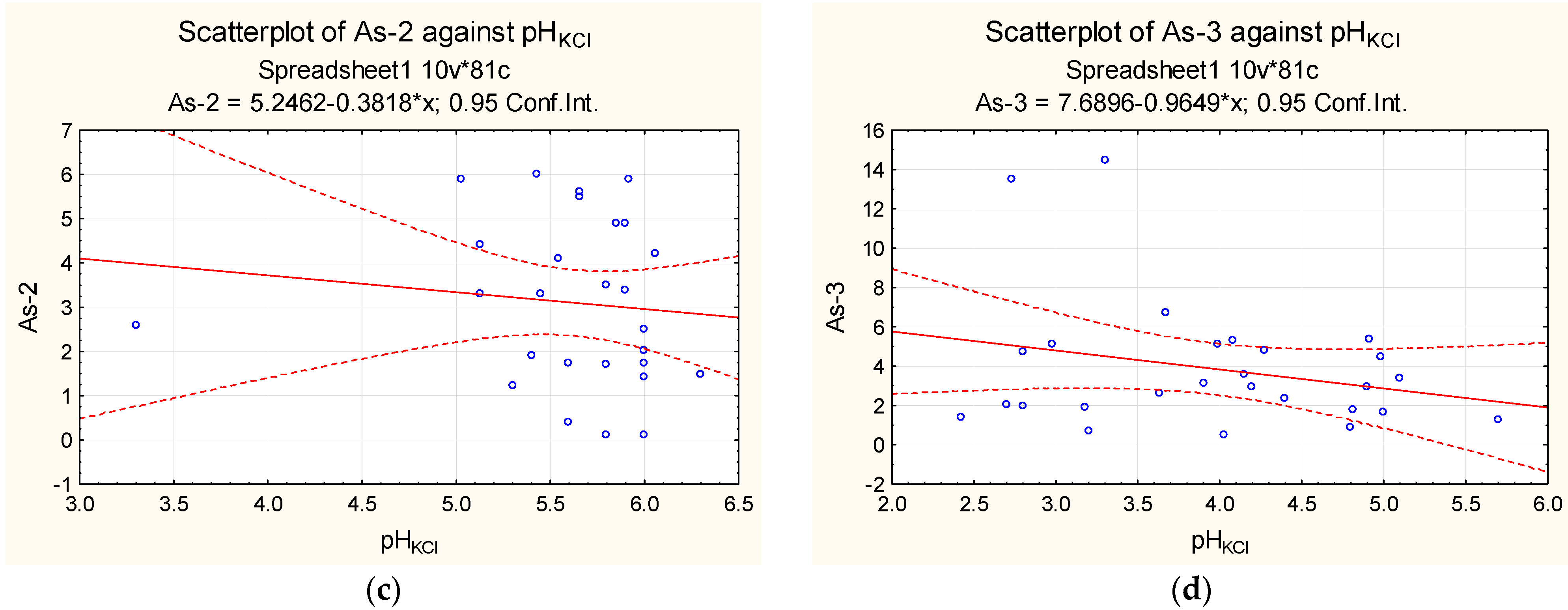
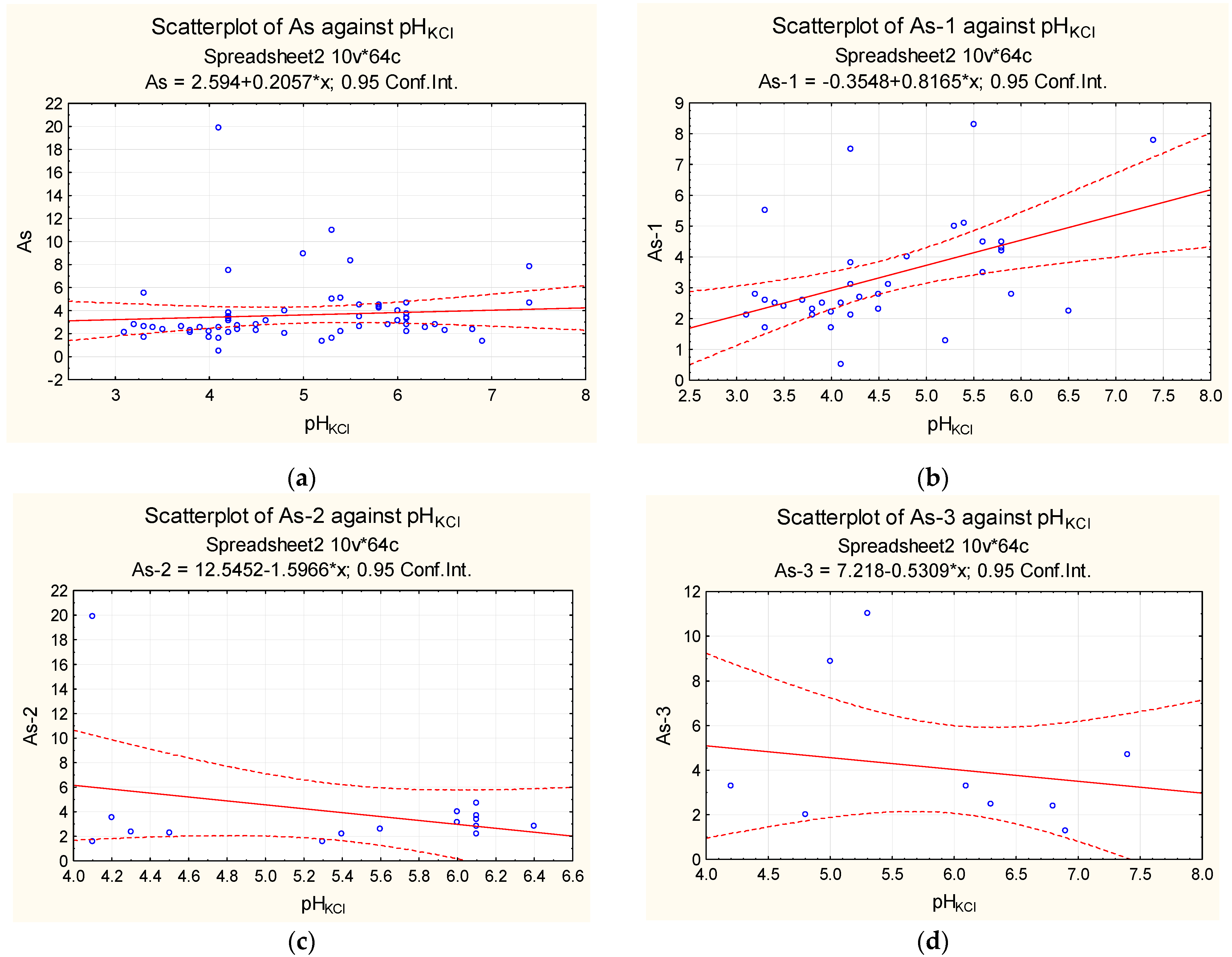
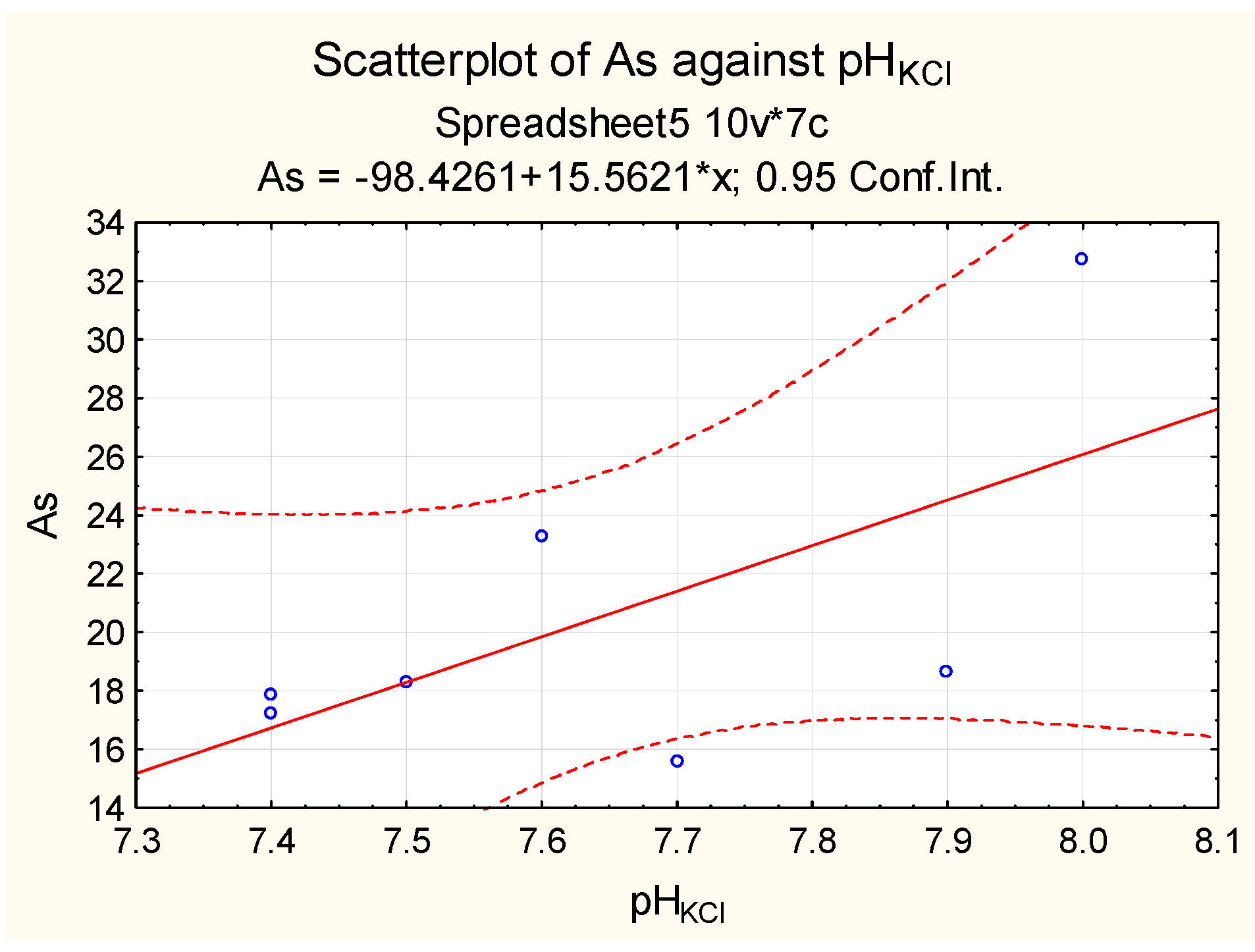
No correlation was found between arsenic content and the soil pHKCl (Figure 1 and Figure 2, Table 2). The lack of a strong correlation can be explained by the prevailing range of pHKCl values. Only 2% of the total number of soil samples fell within the pHKCl range from 7 to 10, which is characterised by a decrease in arsenic adsorption by soil colloids [38], while all values were close to its lower limit (pHKCl = 7.4). The observed correlation between arsenic content and pHKCl of soils in the saline areas cannot be considered reliable, as it is not statistically significant (Figure 3, Table 2).
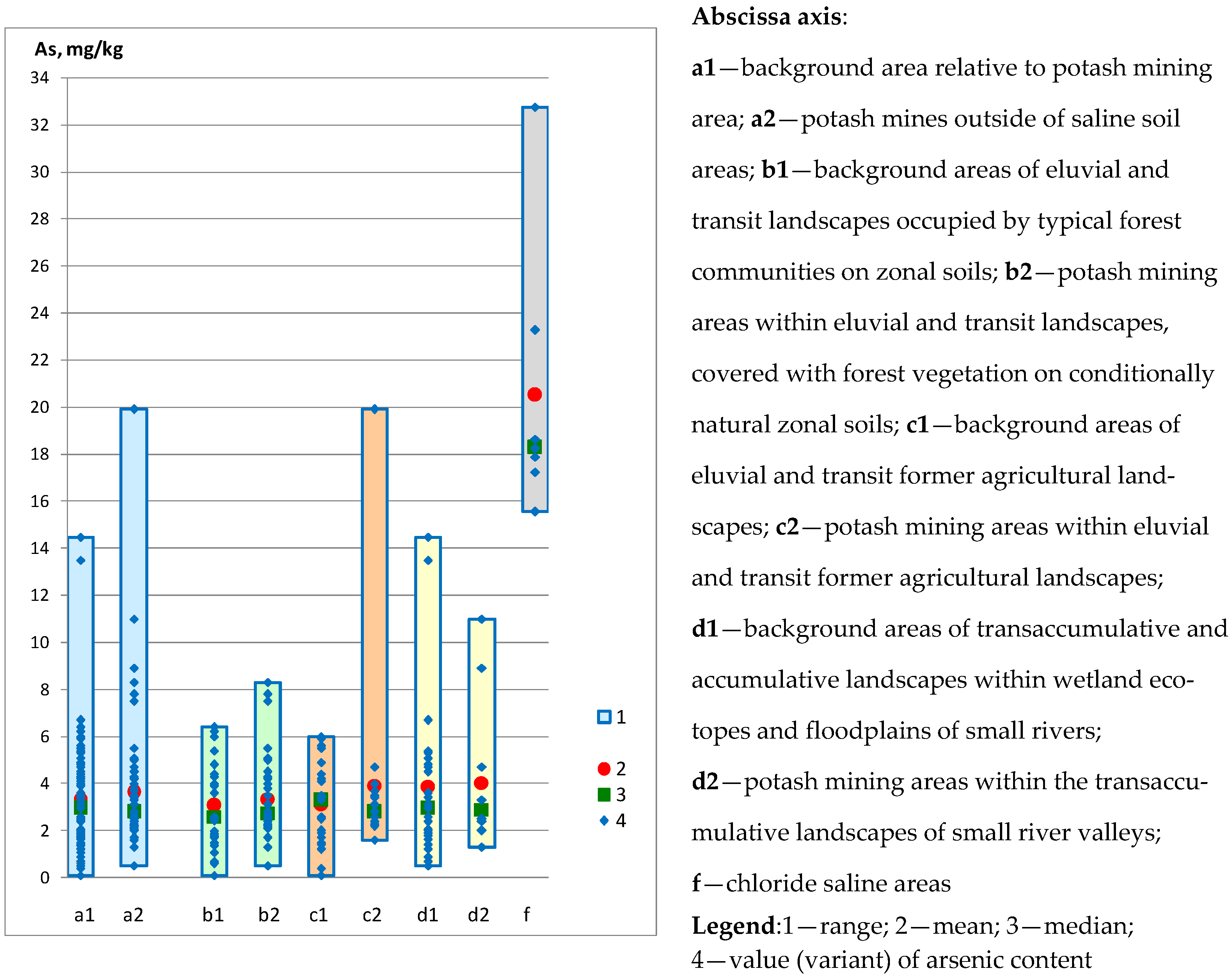
By analysing the features of arsenic distribution in different types of landscapes (Table 3, Table 4 and Table 5, Figure 4 and Figure 5), the following patterns can be identified. Arsenic concentrations in both background and potash mining territories vary considerably (from n × 10−1 to n × 10), with 97% of values falling within the range from n × 10−1 to n. A smaller range of variation and the most uniform distribution were found for areas of eluvial and transit landscapes occupied by typical forest communities on zonal soils, both in background areas and potash mining areas, and for background areas of eluvial and transit former agricultural landscapes. There were no statistically significant differences in arsenic content in the soils of potash mining areas outside of saline areas and the background areas. The concentration factors, calculated as the ratio of average arsenic concentrations in the soils of potash mining territories to the average concentrations in the background areas, are 1.04–1.26. The contamination factor ( C F ) values for As are moderate. The ecological risk factor ( E r i ) values for As regarding the toxicity response factor ( T r i ) are 10.41–12.65, indicating low risk, both for the area as a whole and for each of the identified landscape types. There are also no statistically significant differences in arsenic content in the soils of the examined landscape types.
Dissolved sulphate, nitrate, and chloride in saline soil concentrations were shown to have little effect on arsenic adsorption [38]. Nonetheless, studies have found higher arsenic concentrations in saline soils than in the rest of the area. Arsenic concentrations in saline soils are comparable to those in solid wastes from potassium production, as shown in [26]. The concentration factors of average values are 6.12 in relation to background territories and 5.65 in relation to potash mining territories outside of saline areas. The contamination factor ( C F ) values for As are very high. The ecological risk factor ( E r i ) for As regarding the toxicity response factor ( T r i ) is 61.22, indicating moderate risk.
Outside of saline areas, the average arsenic content in soils of both background and potash mining territories is lower than the average regional contents shown in [29]. Relative to the calculated regional average content [29], soils are characterised by element dispersion: the factor of dispersion within background areas ranges from 1.94 to 2.46; within potash mining areas, it ranges from 1.86 to 2.24. Soils in saline areas relative to the calculated regional average content [29] are characterised by element accumulation: the concentration factor is 2.73.
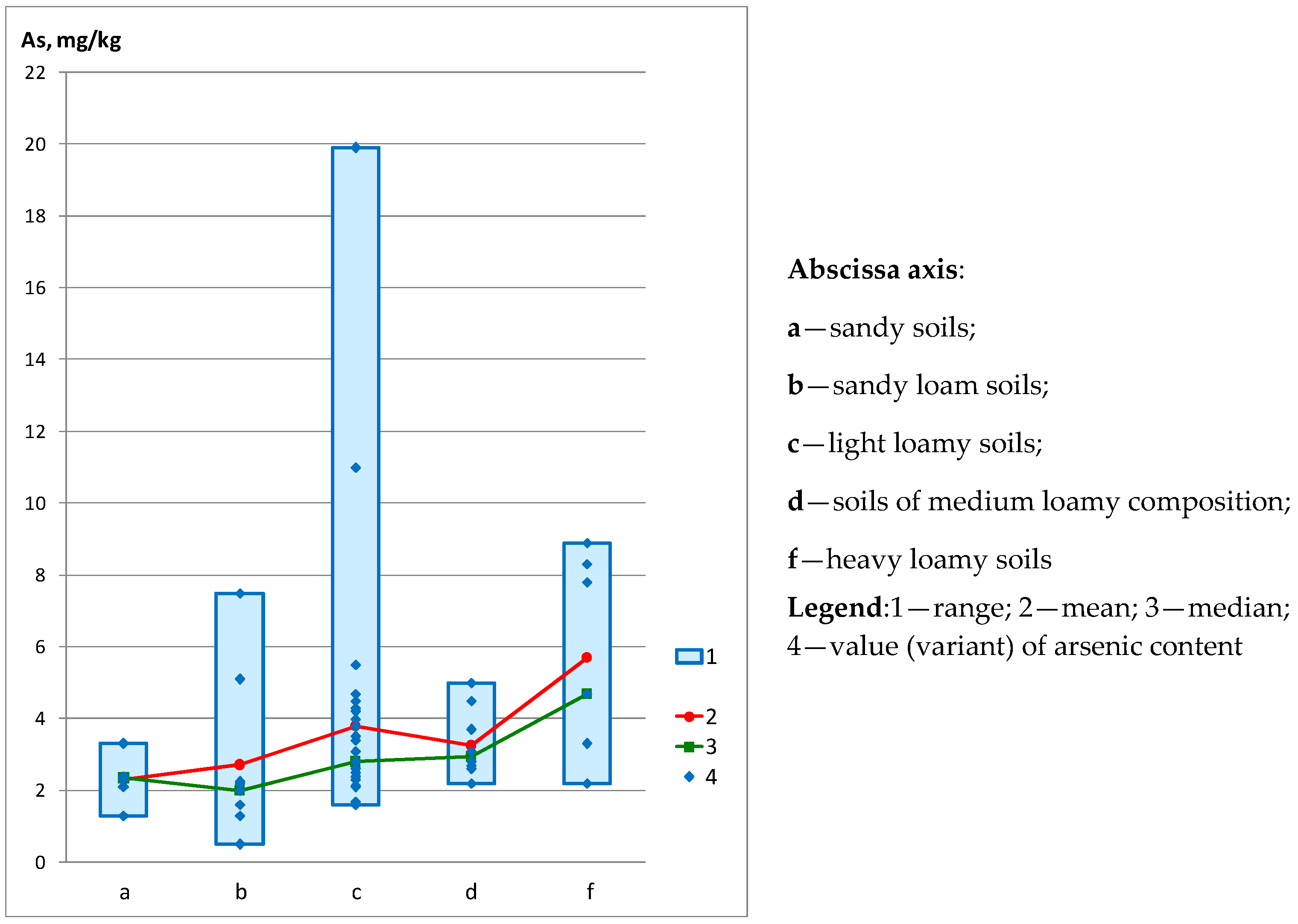
Arsenic concentrations differ statistically in soils with different granulometric compositions (Table 2 and Table 5, Figure 5). The average arsenic content in soils of heavy loam composition is 1.5–2.5 times higher than its average content in other soils. Minimum average values are typical of soils with prevailing sandy fractions in their granulometric composition. The identified characteristics support the role of clay particles as an adsorbent.
In environmental studies, permissible arsenic concentrations in soils are determined based on particle size distribution and pHKCl. In Russia, the permissible concentration is 2 mg/kg for sandy and sandy loam soils, 5 mg/kg for sour (pHKCl < 5.5) loamy and clayey soils, and 10 mg/kg for near neutral and neutral (pHKCl > 5.5) loamy and clayey soils.
Soils of potash mining territories outside of saline areas in 20% of cases exceed permissible concentrations by 1.05–3.98 times. The ranges of exceedances in soils of different granulometric composition are similar: 1.05–3.75 in soils of sandy and sandy loam composition, and 1.1–3.98 in loamy and clayey soils. Despite their lower adsorption capacity, sandy soils consistently exceed the permissible values (69% of cases). This is due to the lower permissible arsenic concentrations in sandy and sandy loam soils.
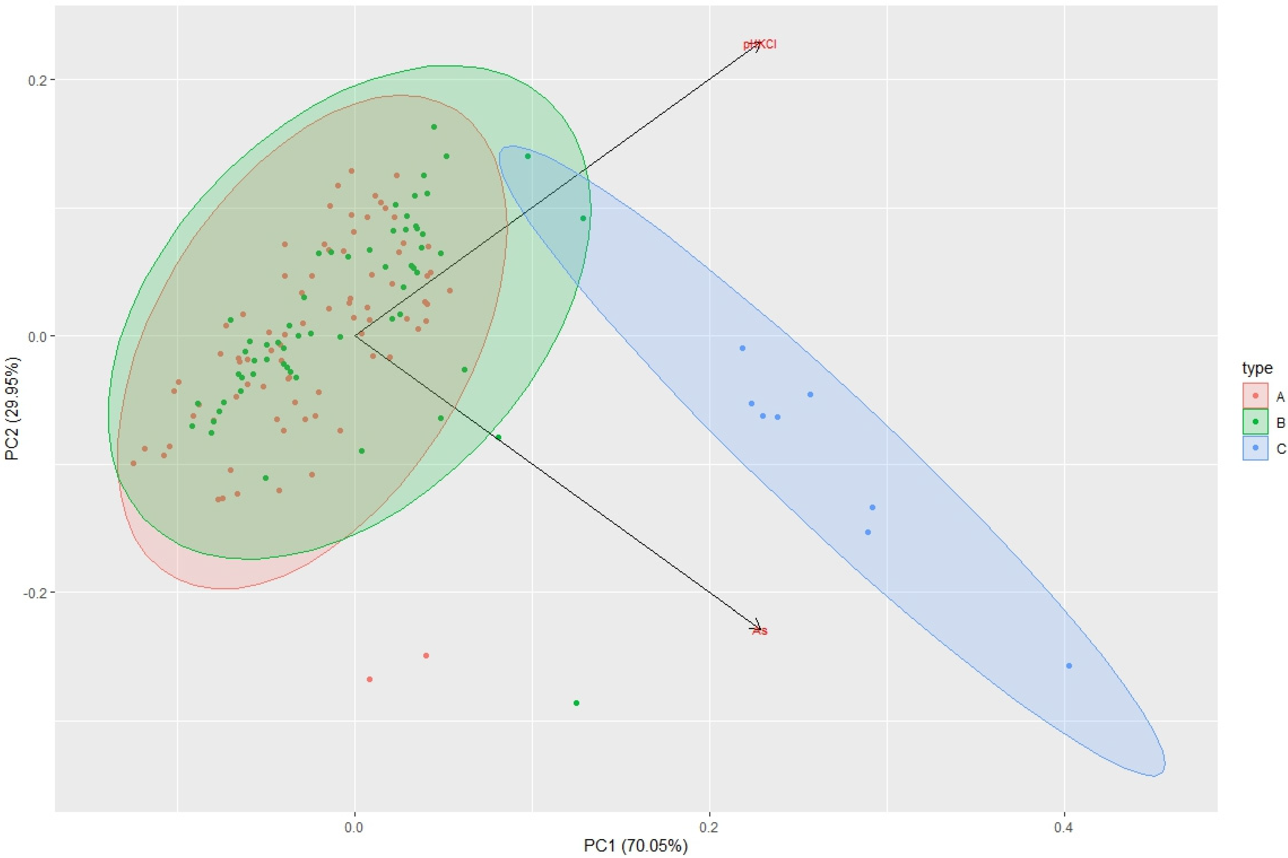
The principal component analysis (PCA) was used to detect patterns and analyse linear dependencies in samples of arsenic and pHKCl concentrations in background areas as well as non-saline and saline areas near potash enterprises(Figure 6). The first PC1 axis explains 70.05% of the total variance between samples and the second PC2 axis explains 29.95%.
Figure 6 shows the general distribution patterns of arsenic and pHKCl for Samples A (background area) and B (potash mining areas outside of saline areas), with changes in acid–alkaline conditions playing the most essential role. Sample C (saline areas near potash mines) has considerably more variation in arsenic content.
The world’s largest potash mining operations (Russia, Belarus, and Germany) are located in temperate latitudes in a humid climate zone [40,41]. Therefore, it can be assumed that the patterns of arsenic distribution in soils of potash mining areas in other countries with similar environmental conditions will be similar to those identified in this study.

4. Conclusions

The findings show a significant range of variation in arsenic concentrations in soils from both potash mining areas and background areas. In 97% of cases, arsenic concentrations range from n × 10−1 to n. No statistically significant differences in arsenic concentrations were found in the soils of potash mining territories, background territories, and soils of different types of landscapes. The soils of saline areas have higher arsenic concentrations than the rest of the territories. The arsenic concentrations in saline soils are comparable to those found in potash production solid waste. Saline areas are distributed locally, usually near salt waste disposal sites (salt dumps, sludge storages).
Despite high arsenic concentrations in the insoluble salt rock residue and solid waste from potash production, the identified patterns suggest that the activities of the potash companies operating in the Verkhnekamskoe potassium salt deposit are not determinants in the technophilic accumulation of arsenic in potash mining territories outside of saline areas. Arsenic concentrations in background soils can be used to adjust its regional background concentrations. Information on this toxic element is required by environmental studies for construction projects.

Author Contributions

Conceptualization, T.K. and E.M.; data curation, V.Z.; formal analysis, V.Z.; funding acquisition, T.K. and E.M.; investigation, T.K. and P.B.; methodology, T.K., E.M. and P.B.; project administration, T.K. and E.M.; resources, E.M.; software, E.M.; supervision, E.M.; validation, E.M.; visualization, T.K. and P.B.; writing—original draft, T.K. and V.Z.; writing—review and editing, T.K., E.M. and P.B. All authors have read and agreed to the published version of the manuscript.

Funding

The research was supported by the Perm Research and Education Centre for Rational Use of Subsoil, 2022.

Data Availability Statement

Not applicable.

Conflicts of Interest

The authors declare no conflict of interest.

References

  1. Kolobanov, K.A.; Filatova, M.Y.; Bubnova, M.B.; Romashkina, E.A. Improving valuation of ecosphere pollution from mining waste using mathematical tools. Min. Inf. Anal. Bull. 2021, 4, 85–99. (In Russian) [Google Scholar] [CrossRef]
  2. Lalmalsawmi, J.; Zirlianngura; Tiwari, D.; Lee, S. Low cost, highly sensitive and selective electrochemical detection of arsenic (III) using silane grafted based nanocomposite. Environ. Eng. Res. 2020, 25, 579–587. [Google Scholar] [CrossRef]
  3. Gupta, A.D.; Giri, B.S.; Rene, E.R.; Chaturvedi, P.; Goswami, M.; Singh, H. Batch and continuous reactor studies for the adsorption of As(III) from wastewater using a hybrid biochar loaded with transition metal oxides: Kinetics and mass transfer analysis. Environ. Eng. Res. 2021, 26, 200438. [Google Scholar] [CrossRef]
  4. Khosravi-Darani, K.; Rehman, Y.; Katsoyiannis, I.A.; Kokkinos, E.; Zouboulis, A.I. Arsenic Exposure via Contaminated Water and Food Sources. Water 2022, 14, 1884. [Google Scholar] [CrossRef]
  5. Tiwari, D.; Jamsheera, A.; Zirlianngura; Lee, S. Use of hybrid materials in the trace determination of As(V) from aqueous solutions: An electrochemical study. Environ. Eng. Res. 2017, 22, 186–192. [Google Scholar] [CrossRef]
  6. Jung, Y.; Kamimoto, Y. Arsenic removal properties by electrolyzed and calcined manganese dioxide. Environ. Eng. Res. 2020, 25, 735–741. [Google Scholar] [CrossRef]
  7. Peng, Y.; Li, Y.; Tang, S.; Zhang, L.; Zhang, J.; Zhao, Y.; Zhang, X.; Zhu, Y. Dynamic Adsorption of As(V) onto the Porous α-Fe2O3/Fe3O4/C Composite Prepared with Bamboo Bio-Template. Water 2022, 14, 1848. [Google Scholar] [CrossRef]
  8. Sun, Y.; Yu, F.; Han, C.; Houda, C.; Hao, M.; Wang, Q. Research Progress on Adsorption of Arsenic from Water by Modified Biochar and Its Mechanism: A Review. Water 2022, 14, 1691. [Google Scholar] [CrossRef]
  9. Voronchikhina, E.A.; Zhdakaev, V.I. Arsenic in natural and technogenic geosystems of the Perm Territory. In Proceedings of the Sergeev Readings. Materials of the Annual Session of the Scientific Council of the Russian Academy of Sciences on the Problems of Geoecology, Engineering Geology and Hydrogeology, Perm, Russia, 2–4 April 2019; pp. 278–283. (In Russian). [Google Scholar]
  10. Liu, G.; Shi, Y.; Guo, G.; Zhao, L.; Niu, J.; Zhang, C. Soil pollution characteristics and systemic environmental risk assessment of a large-scale arsenic slag contaminated site. J. Clean. Prod. 2020, 251, 119721. [Google Scholar] [CrossRef]
  11. Mayorova, L.P.; Cherentsova, A.A.; Krupskaya, L.T.; Golubev, D.A.; Kolobanov, K.A. Assessment of manmade air pollution due to dusting at mine tailings storage facilities. Min. Inf. Anal. Bull. 2021, 1, 5–20. (In Russian) [Google Scholar] [CrossRef]
  12. Krupskaya, L.T.; Zvereva, V.P.; Sklyarova, G.F.; Orlov, A.M. Aboveground mining waste storage as an ecosphere pollution source and waste exploitability in Russia’s Far East. Min. Inf. Anal. Bull. 2021, 2, 5–21. (In Russian) [Google Scholar] [CrossRef]
  13. Abramov, B.N. Toxicity assessment of mine tailings ponds in Transbaikalia. Min. Inf. Anal. Bull. 2021, 11, 136–145. (In Russian) [Google Scholar] [CrossRef]
  14. Rastanina, N.K.; Golubev, D.A.; Shavrin, E.I. Ecosphere and health conditions within the influence zone of a closed mine in Primorye. Min. Inf. Anal. Bull. 2021, 3, 114–127. (In Russian) [Google Scholar] [CrossRef]
  15. Ran, H.; Guo, Z.; Yi, L.; Xiao, X.; Zhang, L.; Hu, Z.; Li, C.; Zhang, Y. Pollution characteristics and source identification of soil metal(loid)s at an abandoned arsenic-containing mine, China. J. Hazard. Mater. 2021, 413, 125382. [Google Scholar] [CrossRef] [PubMed]
  16. Álvarez-Quintana, J.; Álvarez, R.; Ordóñez, A. Arsenic in Soils Affected by Mining: Microscopic Studies vs. Sequential Chemical Extraction. Int. J. Environ. Res. Public Health 2020, 17, 8426. [Google Scholar] [CrossRef]
  17. Kachor, O.L. Development of a model for the migration of arsenic along the soil profile from accumulated waste from the mining industry. Earth Sci. Subsoil Use 2019, 42, 144–150. (In Russian) [Google Scholar] [CrossRef]
  18. Bailey, A.S.; Jamieson, H.E. Characterization of arsenic-hosting solid phases in tailings dust from giant mine: Implications for air quality monitoring at legacy mine sites. Geol. Soc. Am. Abstr. Programs 2017, 49, 6. [Google Scholar] [CrossRef]
  19. Khayrulina, E.A.; Khomich, V.S.; Liskova, M.Y. Environmental issues of potash deposit development. Izvestiya TulGU. Earth Sci. 2018, 2, 112–126. (In Russian) [Google Scholar]
  20. Khayrulina, E.; Mitrakova, N.; Poroshina, N.; Menshikova, E.; Perminova, A. Formation of solonchak in the area of the discharged ancient brine wells (Perm krai, Russia). Front. Environ. Sci. 2022, 10, 858742. [Google Scholar] [CrossRef]
  21. Menshikova, E.A.; Voronchikhina, E.A.; Zhdakaev, V.I. Water migration technophilic elements in the extraction and processing of minerals salts: Problems and prospects of ecologizations. In Proceedings of the Modern Problems of Reservoirs and Their Watersheds: VII All-Russian Scientific and Practical Conference with International Participation, Perm, Russia, 2 June 2019; pp. 150–155. (In Russian). [Google Scholar]
  22. Baboshko, A.Y.; Bachurin, B.A. Heavy metals in potash industry waste. Min. Inf. Anal. Bull. 2009, 5, 369–376. (In Russian) [Google Scholar]
  23. Tchaikovsky, I.I.; Utkina, T.A.; Isaeva, G.A. Evolution of the mineral composition of the insoluble salt residue of the Verkhnekamskoye deposit. Gorn. Echo 2021, 4, 17–20. (In Russian) [Google Scholar] [CrossRef]
  24. Smetannikov, A.F.; Onosov, D.V.; Sinegribov, V.A.; Novikov, P.Y. Noble metal extraction from K-Mg ore processing waste. Min. Inf. Anal. Bull. 2013, S4, 216–231. (In Russian) [Google Scholar]
  25. Bayandina, E.O.; Kudryashov, A.I. Insoluble Salt Residue of the Verkhnekamsk Deposit; Tipograf: Perm, Russia, 2015; pp. 21–36. [Google Scholar]
  26. Khokhryakova, E.S. Ecogeochemical assessment of solid potash waste based on the content of trace elements. Gorn. Echo 2020, 3, 30–35. (In Russian) [Google Scholar] [CrossRef]
  27. Belkin, P.A.; Kataev, V.N. Regularities of the chemical composition of technogenic transformation which groundwater undergoes in the areas of the potash deposits development. News Ural. State Min. Univ. 2018, 2, 55–64. (In Russian) [Google Scholar] [CrossRef]
  28. Smetannikov, A.F.; Filippov, V.N. Some features of the mineral composition of salt rocks and products of their processing (on the example of the Verkhnekamsk salt deposit). In Problems of Mineralogy, Petrography and Metallogeny. Scientific Readings in Memory of P.N. Chirvinsky; PSU: Perm, Russia, 2010; Volume 13, pp. 99–113. (In Russian) [Google Scholar]
  29. Dziuba, E.A. Determination of local background content of some macro- and microelements in the soils of the Perm region. Geogr. Bull. 2021, 1, 95–108. (In Russian) [Google Scholar] [CrossRef]
  30. Opekunova, M.G.; Opekunov, A.Y.; Kukushkin, S.Y.; Ganul, A.G. Background contents of heavy metals in soils and bottom sediments in the north of Western Siberia. Eurasian Soil Sci. 2019, 52, 380–395. (In Russian) [Google Scholar] [CrossRef]
  31. Gost 26483-85; Soils. Preparation of Salt Extract and Determination of its PH by CINAO Method. The National Standard. USSR State Committee for Standards: Moscow, Russia, 1985; 6p. (In Russian)
  32. Lê, S.; Josse, J.; Husson, F. FactoMineR: An R package for multivariate analysis. J. Stat. Softw. 2008, 25, 1–18. [Google Scholar] [CrossRef]
  33. Wickham, H. ggplot2: Elegant Graphics for Data Analysis; Springer: New York, NY, USA, 2009; pp. 2197–5736. [Google Scholar]
  34. Ruiz-Roso, J.; García-Lorenzo, M.L.; Castiñeiras, P.; Muñoz-Martín, A.; Crespo-Feo, E. 3D Spatial Distribution of Arsenic in an Abandoned Mining Area: A Combined Geophysical and Geochemical Approach. Minerals 2020, 10, 1130. [Google Scholar] [CrossRef]
  35. Hakanson, L. An ecological risk index for aquatic pollution control, a sedimentological approach. Water Res. 1980, 14, 975–1001. [Google Scholar] [CrossRef]
  36. Pan, L.; Guan, X.; Liu, B.; Chen, Y.; Pei, Y.; Pan, J.; Zhang, Y.; Hao, Z. Pollution Characteristics, Distribution and Ecological Risk of Potentially Toxic Elements in Soils from an Abandoned Coal Mine Area in Southwestern China. Minerals 2021, 11, 330. [Google Scholar] [CrossRef]
  37. Yuan, D.; Liu, Y.; Guo, X.; Liu, J. Characteristic contaminants in snowpack and snowmelt surface runoff from different functional areas in Beijing, China. Environ. Sci. Pollut. Res. 2018, 25, 36256–36266. [Google Scholar] [CrossRef] [PubMed]
  38. Putilina, V.S.; Galitskaya, I.V.; Yuganova, T.I. The Behavior of Arsenic in Soils, Rocks and Groundwater. Transformation, Adsorption/Desorption, Migration; State Public Scientific and Technical Library of the Siberian Branch of the Russian Academy of Sciences: Novosibirsk, Russia, 2011; 249p. (In Russian) [Google Scholar]
  39. Gonçalves, D.A.M.; Pereira, W.V.d.S.; Johannesson, K.H.; Pérez, D.V.; Guilherme, L.R.G.; Fernandes, A.R. Geochemical Background for Potentially Toxic Elements in Forested Soils of the State of Pará, Brazilian Amazon. Minerals 2022, 12, 674. [Google Scholar] [CrossRef]
  40. Prakash, S.; Verma, J.P. Global Perspective of Potash for Fertilizer Production. In Potassium Solubilizing Microorganisms for Sustainable Agriculture; Meena, V., Maurya, B., Verma, J., Meena, R., Eds.; Springer: New Delhi, India, 2016. [Google Scholar] [CrossRef]
  41. Garrett, D.E. Potash: Deposits, Processing, Properties and Uses; Springer Science & Business Media: Berlin/Heidelberg, Germany, 2012. [Google Scholar]
Figure 1. Dependence of arsenic content in background soils on pHKCl: (a) background area relative to potash mining area (As); (b) background areas of eluvial and transit landscapes occupied by typical forest communities on zonal soils (As-1); (c) background areas of eluvial and transit former agricultural landscapes (As-2); (d) background areas of transaccumulative and accumulative landscapes within wetland ecotopes and floodplains of small rivers (As-3).
Minerals 12 01029 g001aMinerals 12 01029 g001b
Figure 2. Dependence of arsenic content in soils of potash mining areas on pHKCl: (a) potash mining areas outside of soil salinisation areas (As); (b) potash mining areas within eluvial and transit landscapes, covered with forest vegetation on conditionally natural zonal soils (As-1); (c) potash mining areas within eluvial and transit former agricultural landscapes(As-2); (d) potash mining areas within the transaccumulative landscapes of small river valleys (As-3).
Minerals 12 01029 g002
Figure 3. Dependence of arsenic content in soils of saline areas.
Minerals 12 01029 g003
Figure 4. Change in arsenic content of soils.
Minerals 12 01029 g004
Figure 5. Change in arsenic content in soils of potash mining areas as a function of soil particle size distribution.
Minerals 12 01029 g005
Figure 6. Analysis of the main components for samples A (background area), B (potash mining territories outside of salinity areas), and C (salinity areas).
Minerals 12 01029 g006
Table 1. Variation of pHKCl in soils.
SamplingMin. ValueMax. ValueAverage ValueMedian
Background area relative to potash mining area:
Entire territory (n = 81)2.426.304.564.61
by landscape type:
Areas of eluvial and transit landscapes occupied by typical forest communities on zonal soils (n = 27)2.605.544.104.03
Eluvial and transit former agricultural landscapes (n = 27)3.306.305.615.80
Transaccumulative and accumulative landscapes within wetland ecotopes and floodplains of small rivers (n = 27)2.425.703.954.03
Potash mining areas outside of soil salinisation areas:
Entire territory (n = 64)3.107.405.034.90
by landscape type:
Areas of eluvial and transit landscapes occupied by forest vegetation on conditionally natural zonal soils (n = 36)3.107.404.554.20
Eluvial and transit former agricultural landscapes (n = 16)4.106.405.405.80
Transaccumulative landscapes within small river valleys (n = 12)4.207.405.986.20
Areas of soil salinisation in the zone affected by the potash industry:
Chloride-type soil salinity areas—content Cl 1.49–36.35 g/kg
(n = 7)
7.408.007.647.60
Table 2. Assessment of the correlation between arsenic content and soil pHKCl by Spearman’s coefficient (ρ).
Samplingρ *Tightness of Correlation on the Cheddock ScaleStatistical Significance of the Spearman’s Correlation Coefficient
t (ρ)tcriticalcritical)Significance
Assessment
Background area relative to potash mining area:
Entire territory (n = 81)−0.064low−0.5661.991the relationship is not statistically significant
(p = 0.572786)
by landscape type:
Areas of eluvial and transit landscapes occupied by typical forest communities on zonal soils
(n = 27)
0.064low0.0640.382the relationship is not statistically significant (p > 0.05)
Eluvial and transit former agricultural landscapes
(n = 27)
−0.225low−0.2250.382the relationship is not statistically significant (p > 0.05)
Transaccumulative and accumulative landscapes within wetland ecotopes and floodplains of small rivers
(n = 27)
−0.105low−0.1050.382the relationship is not statistically significant (p > 0.05)
Potash mines outside of soil salinisation areas:
entire territory (n = 64)0.276low2.2621.999the relationship is statistically significant (p = 0.027297)
by landscape type:
Areas of eluvial and transit landscapes occupied by forest vegetation on conditionally natural zonal soils
(n = 36)
0.485moderate0.4850.33the relationship is statistically significant (p < 0.05)
Eluvial and transit former agricultural landscapes
(n = 16)
0.229low0.2290.503the relationship is not statistically significant (p > 0.05)
Transaccumulative landscapes within small river valleys
(n = 12)
0.075low0.0750.587the relationship is not statistically significant (p > 0.05)
Areas of soil salinisation in the zone affected by potash industry:
Chloride-type soil salinity areas—content Cl 1.49–36.35 g/kg (n = 7)0.563significant0.5630.786the relationship is not statistically significant (p > 0.05)
* ρ—Spearman’s correlation coefficient; ρcritical—Spearman’s criterion critical value; t—Student t-test; tcritical—critical value of Student’s t-test.
Table 3. Statistical characteristics of arsenic distribution in soils.
SamplingMin. ValueMax. ValueAverage ValueMedianSD *V
mg/kg%
Background area relative to potash mining area:
Entire territory (n = 81)0.1014.483.352.962.4573.17
by landscape type:
Areas of eluvial and transit landscapes occupied by typical forest communities on zonal soils (n = 27)0.106.403.062.601.8259.55
Eluvial and transit former agricultural landscapes (n = 27)0.106.003.103.301.8659.98
Transaccumulative and accumulative landscapes within wetland ecotopes and floodplains of small rivers (n = 27)0.5014.483.882.963.3586.42
Potash mines outside of soil salinisation areas:
Entire territory (n = 64)0.5019.903.632.802.8177.35
by landscape type:
Areas of eluvial and transit landscapes occupied by forest vegetation on conditionally natural zonal soils (n = 36)0.508.303.362.751.7752.67
Eluvial and transit former agricultural landscapes (n = 16)1.6019.903.922.804.34110.71
Transaccumulative landscapes within small river valleys (n = 12)1.3011.004.042.902.9873.70
- on the granulometric composition of soils
Sandy soils (n = 6)1.303.302.302.350.6427.91
Sandy loam soils (n = 9)0.507.502.722.002.1980.52
Light loamy soils (n = 32)1.6019.903.802.803.3989.30
Soils of medium loamy composition (n = 10)2.205.003.252.950.8927.34
Heavy loamy soils (n = 7)2.208.905.704.702.6346.10
Areas of soil salinisation in the zone affected by the potash industry:
Chloride-type soil salinity areas—content Cl 1.49–36.35 g/kg (n = 7)15.5632.7520.5118.275.8928.72
* SD—Standard deviation; V—Coefficient of variation.
Table 4. Mann–Whitney U-test for significance of differences in arsenic content in soils, p < 0.05.
Samplingn *T *U *Ucritical *Assessing the Credibility of Differences
1Background areas of eluvial and transit landscapes occupied by typical forest communities on zonal soils27810432367Differences between samples are
not significant
Potash mining areas within eluvial and transit landscapes, covered with forest vegetation on conditionally natural zonal soils361206
2Background areas of eluvial and transit former agricultural landscapes27588210150Differences between samples are
not significant
Potash mining areas within eluvial and transit former agricultural landscapes16358
3Background areas of transaccumulative and accumulative landscapes within wetland ecotopes and floodplains of small rivers27529151107Differences between samples are
not significant
Potash mining areas within the transaccumulative landscapes of small river valleys12251
* n—number of values in the sample; T—sum of ranks in the sample; U—criterion value; Ucritical—critical importance.
Table 5. Assessment of the significance of differences in arsenic content in soils by Kruskal–Wallis H-criterion, p < 0.05.
Samplingn *T *H *p-ValueAssessing the Credibility of Differences
1Background areas of eluvial and transit landscapes occupied by typical forest communities on zonal soils2710690.34850.84009The result is
not significant
at p < 0.05
Background areas of eluvial and transit former agricultural landscapes271087
Background areas of transaccumulative and accumulative landscapes within wetland ecotopes and floodplains of small rivers271165
2Potash mining areas within eluvial and transit landscapes, covered with forest vegetation on conditionally natural zonal soils3611710.0760.96269The result is
not significant
at p < 0.05
Potash mining areas within eluvial and transit former agricultural landscapes16506
Potash mining areas within the transaccumulative landscapes of small river valleys12403
3Background relative to potash mines area81575919.86660.00005The result
is significant
at p < 0.05
Potash mines outside of soil salinisation areas644831
Areas of soil salinisation in the zone affected by the potash industry71038
4Potash mining areas with sandy soils6115.514.23190.00659The result
is significant
at p < 0.05
Potash mining areas with sandy loam soils9171
Potash mining areas with light loamy soils321077.5
Potash mining areas with medium loamy soils10370.5
Potash mining areas with heavy loam soils7345.5
* n—number of values in the sample; T—sum of ranks in the sample; H—criterion value.
Publisher’s Note: MDPI stays neutral with regard to jurisdictional claims in published maps and institutional affiliations.