Fusion of Lineament Factor (LF) Map Analysis and Multifractal Technique for Massive Sulfide Copper Exploration: The Sahlabad Area, East Iran
Abstract
1. Introduction
2. Geology of the Study Area
2.1. Regional Tectonics
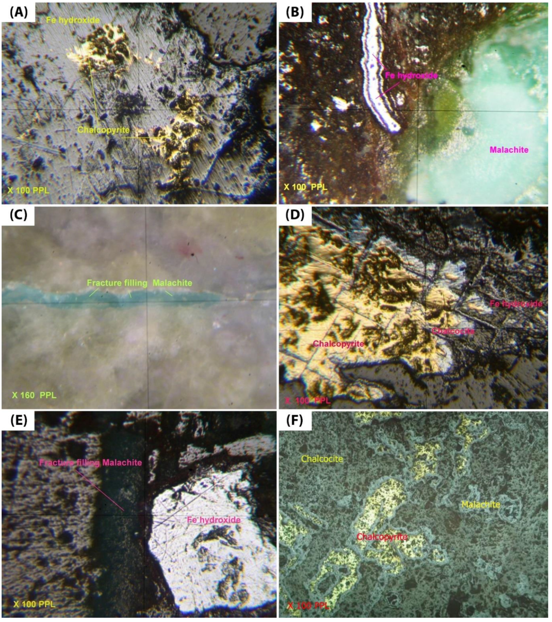
2.2. Copper Mineralization in the Study Area
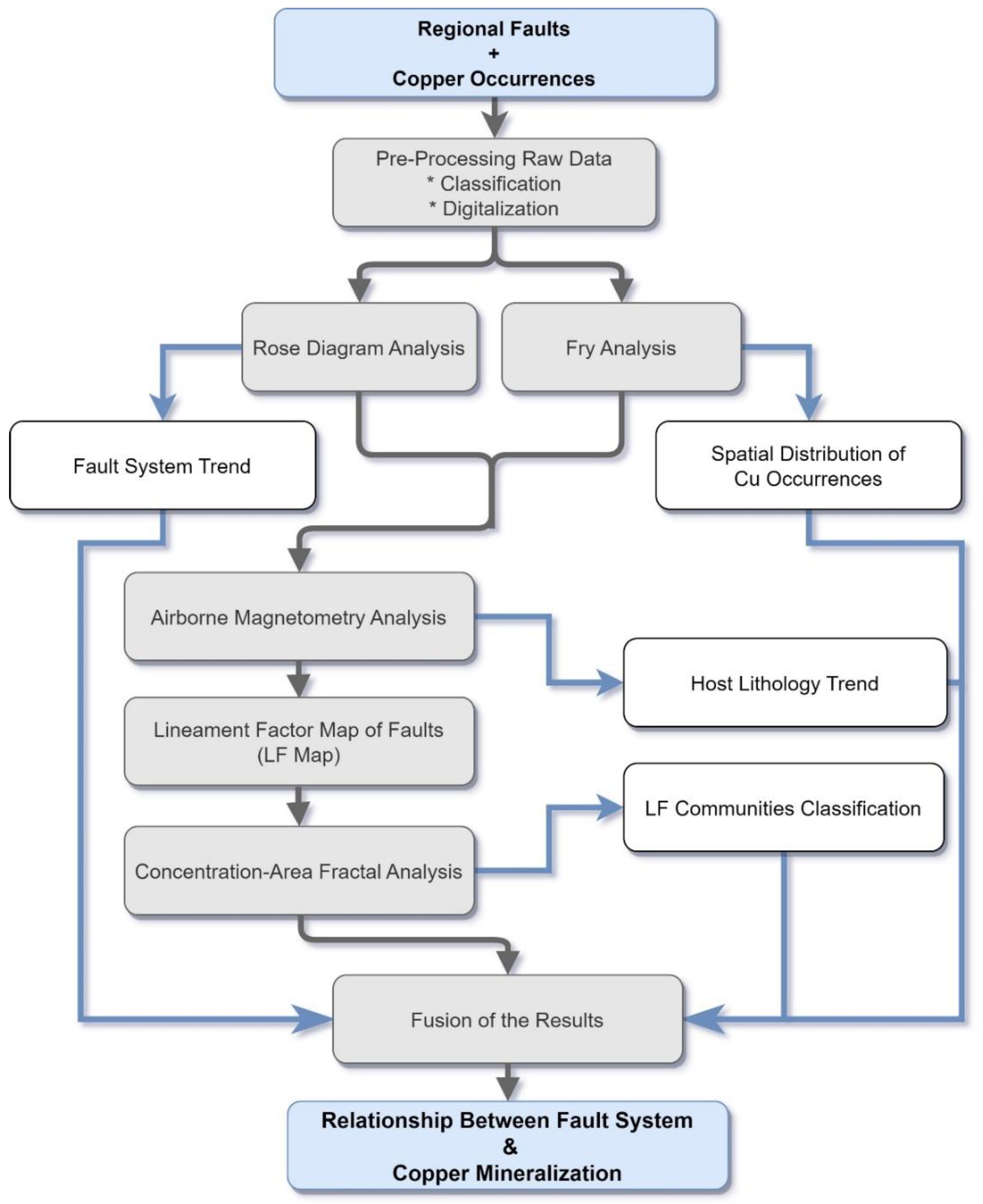
3. Materials and Methods
3.1. Geology and Geophysical Data
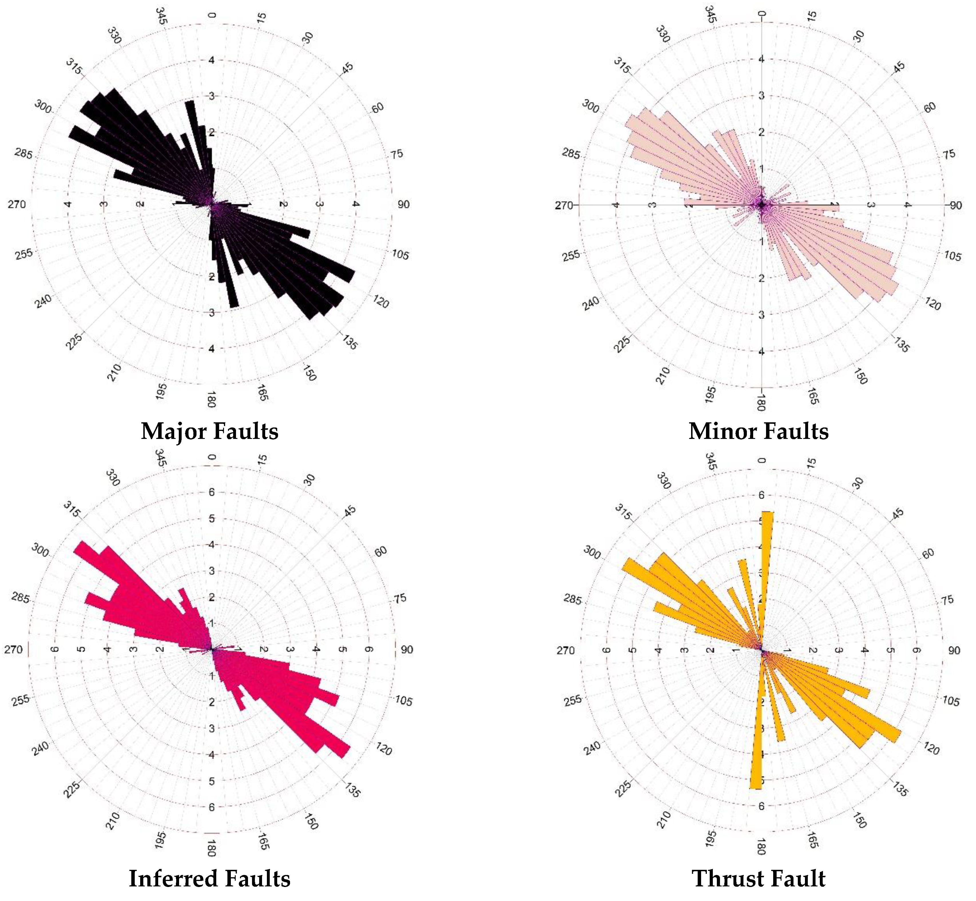
3.2. Rose Diagram Analysis
3.3. Fry Analysis
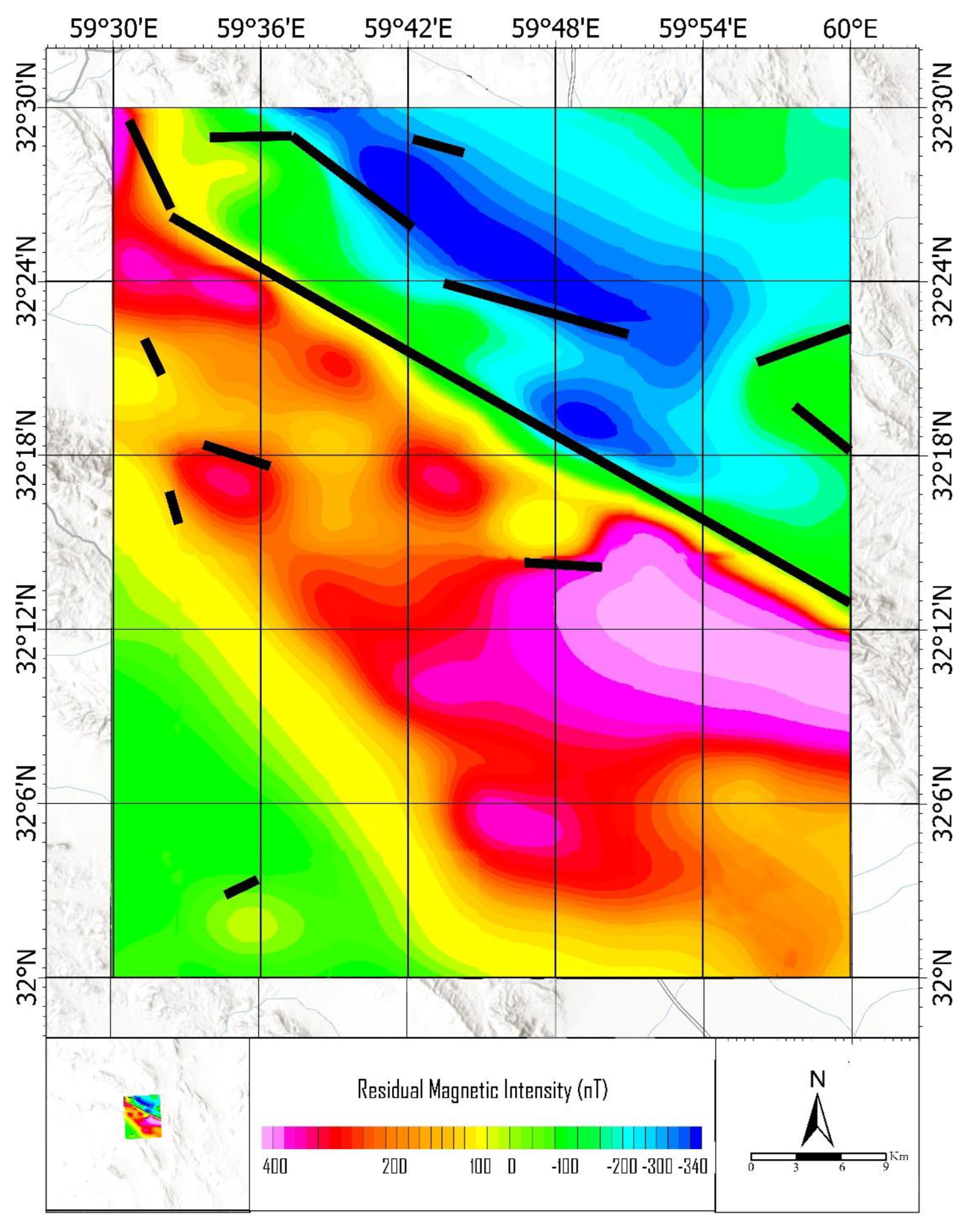
3.4. Airborne Magnetometry Analysis
3.5. Concentration–Area (C-A) Fractal Analysis
4. Analysis and Results
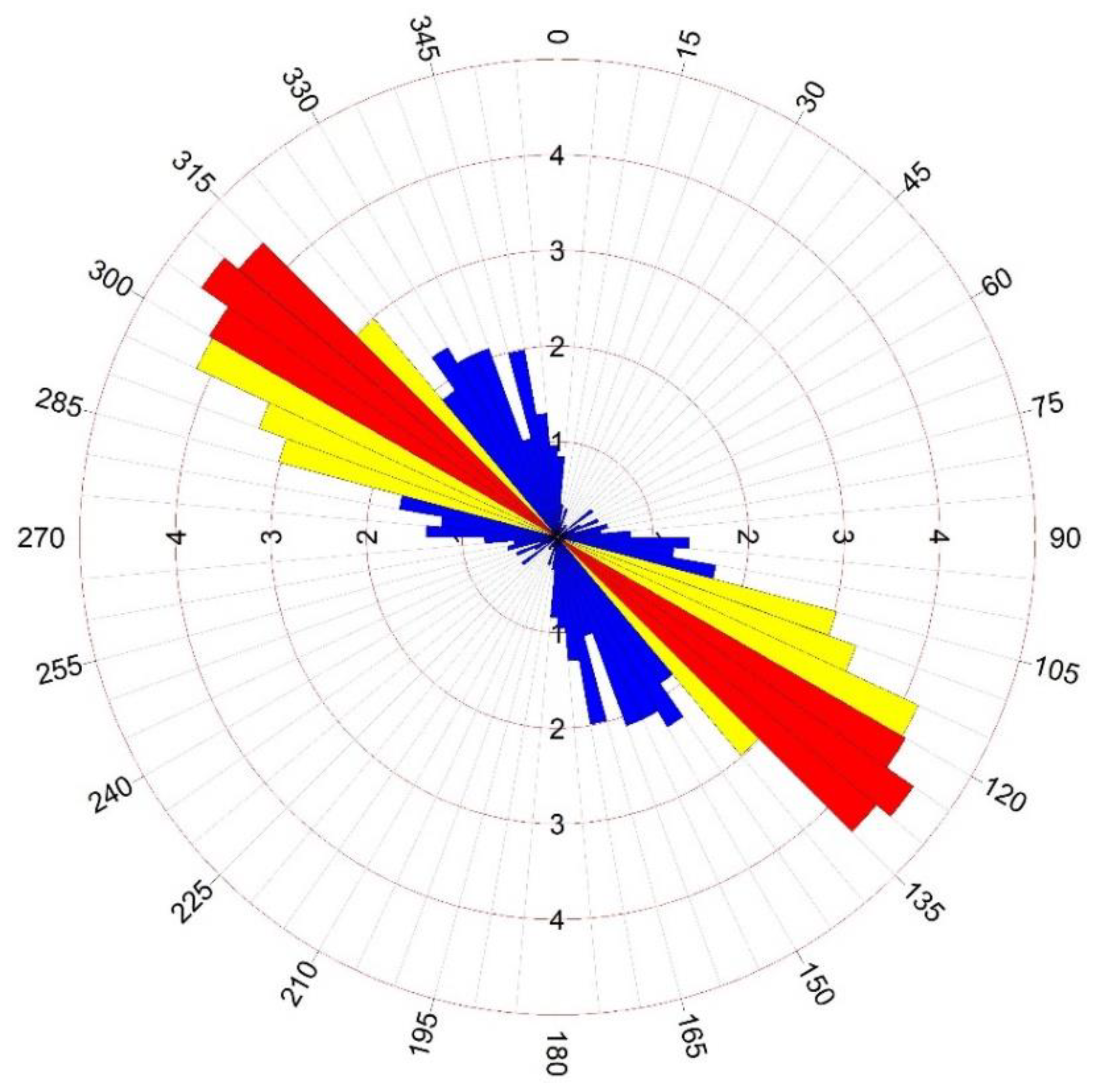
4.1. Rose Diagram Analysis
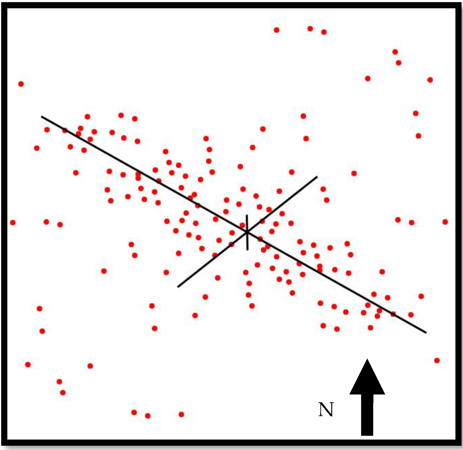
4.2. Fry Analysis
4.3. Lithology Trend Analysis
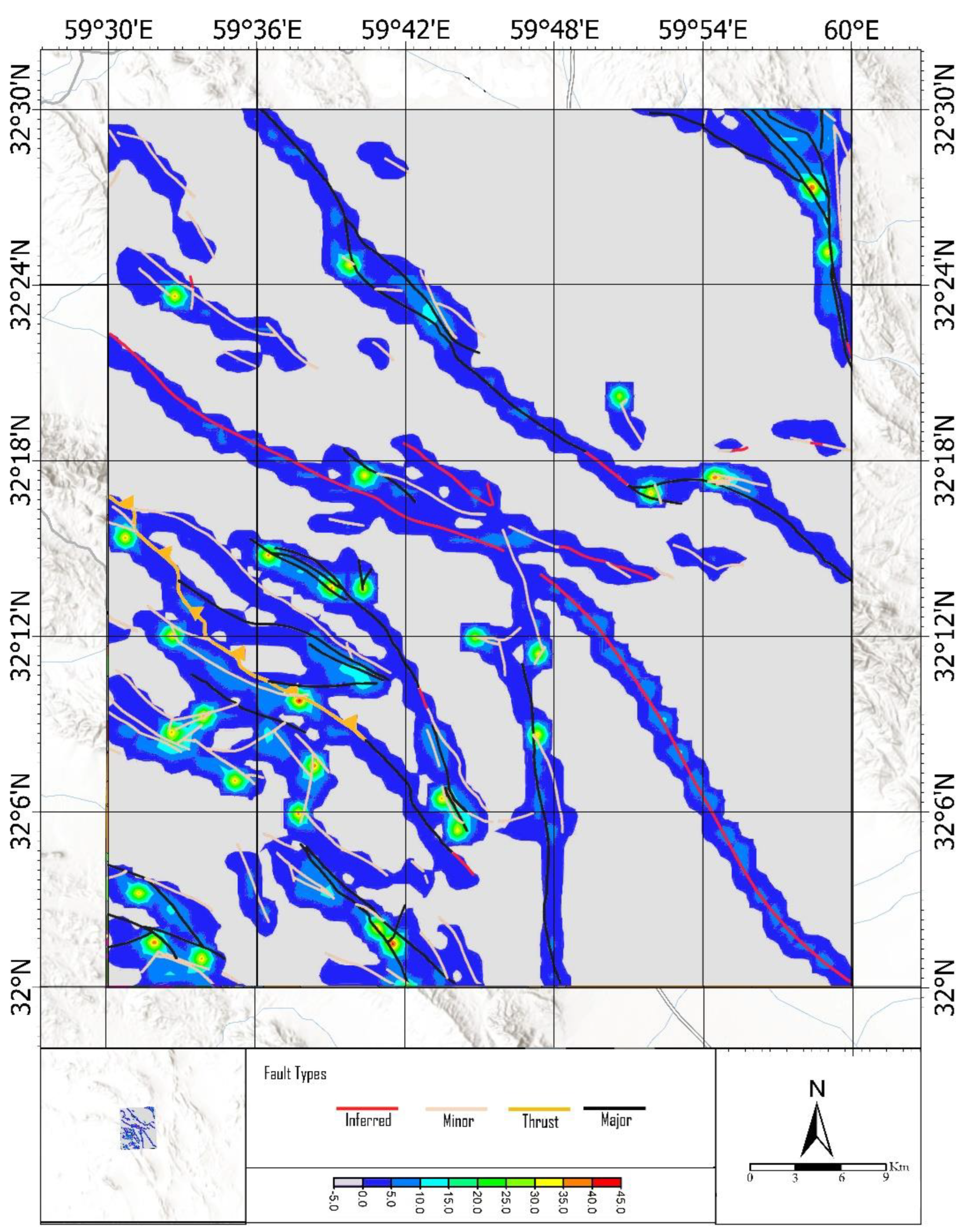
4.4. Lineament Factor (LF) Map Analysis
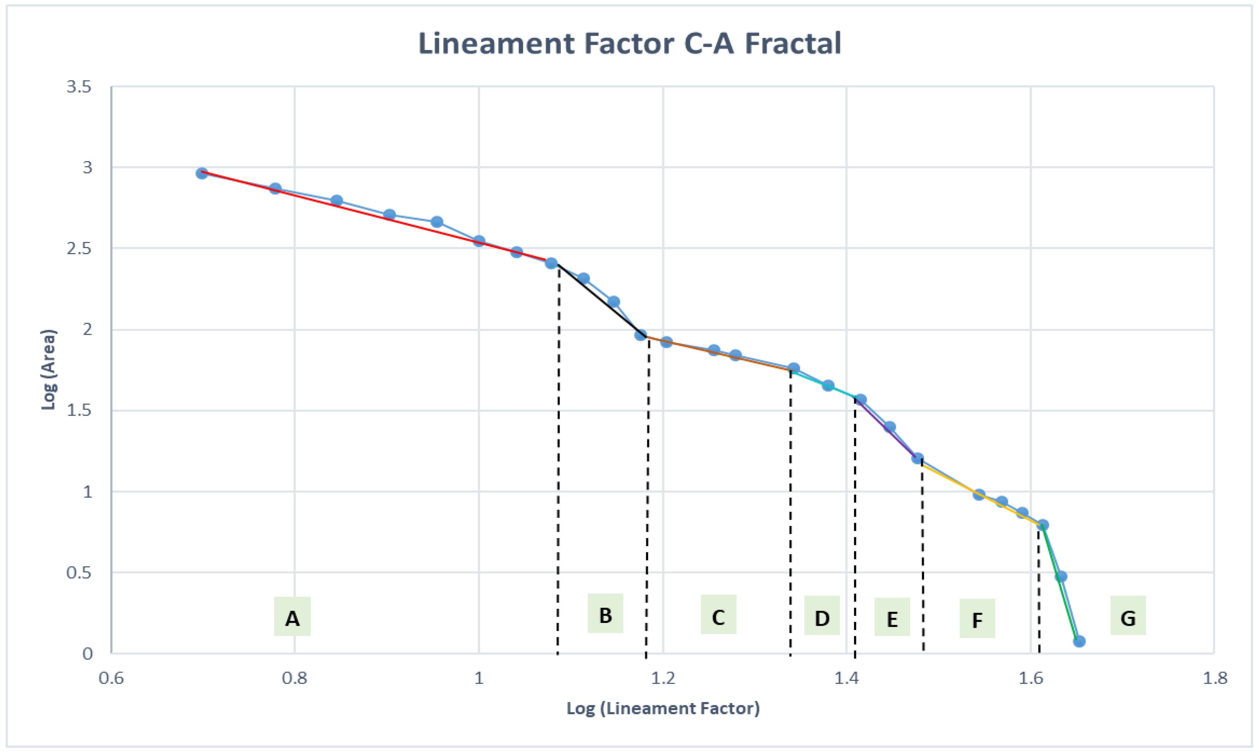
LF Map Classification by Fractal Modeling
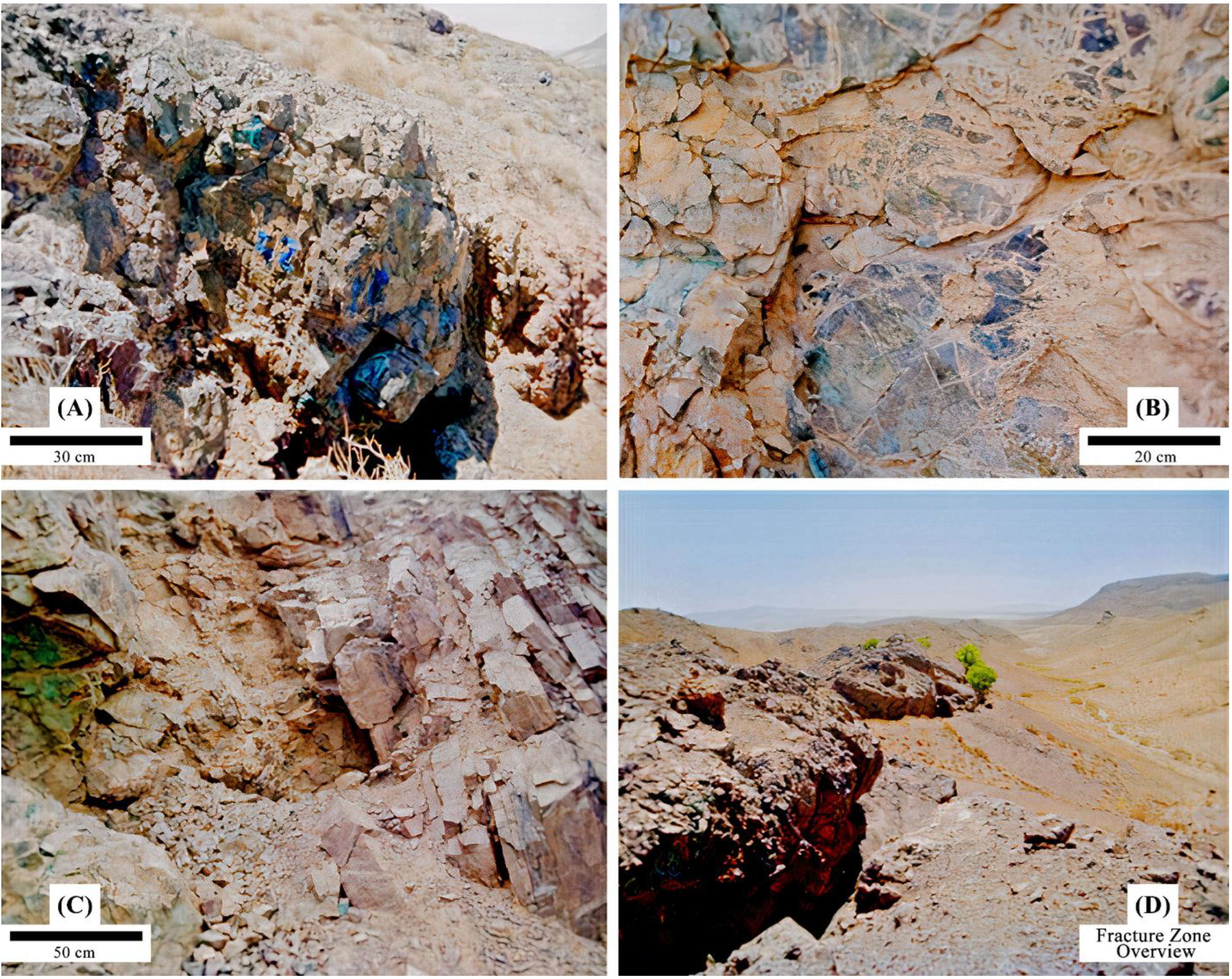
4.5. Field Evidence
5. Discussion
6. Conclusions
- In general, the trend of faults at the regional scale is northwest-southeast, which is consistent with the trend of lithology units related to mineralization.
- Based on the classified information related to faults in mines, deposits and copper indices of the Sahlabad area, it is observed that in most cases, mineralization has taken place at the fault systems that have a trend perpendicular to the faults in the area.
- Studies on airborne magnetometric data indicate that the faults identified by this method are faults associated with intrusive masses, and thus the faults control the lithology trend in the area.
- Overall, it can be said that the faults in the area control the bedrock lithology and the source of massive sulfide copper mineralization in the region, while the regional faults (on a mining scale) in mines, deposits and indices control the mineralization in the region.
Author Contributions
Funding
Data Availability Statement
Acknowledgments
Conflicts of Interest
References
- Hoggard, M.J.; Czarnota, K.; Richards, F.D.; Huston, D.L.; Jaques, A.L.; Ghelichkhan, S. Global distribution of sediment-hosted metals controlled by craton edge stability. Nat. Geosci. 2020, 13, 504–510. [Google Scholar] [CrossRef]
- Prior, Á.; Benndorf, J.; Mueller, U. Resource and grade control model updating for underground mining production settings. Math. Geosci. 2021, 53, 757–779. [Google Scholar] [CrossRef]
- Baseri, F.; Nezafati, N. Structural and Chemical Controllers of the North and Northwest of Torud Based on Involved Fluid Studies, Structural and Geochemical Analyses. Teh. Glas. 2021, 15, 339–349. [Google Scholar] [CrossRef]
- Tuduri, J.; Chauvet, A.; Barbanson, L.; Labriki, M.; Dubois, M.; Trapy, P.-H.; Lahfid, A.; Poujol, M.; Melleton, J.; Badra, L. Structural control, magmatic-hydrothermal evolution and formation of hornfels-hosted, intrusion-related gold deposits: Insight from the Thaghassa deposit in Eastern Anti-Atlas, Morocco. Ore Geol. Rev. 2018, 97, 171–198. [Google Scholar] [CrossRef]
- Malaekeh, A.; Ghassemi, M.R.; Afzal, P.; Solgi, A. Fractal Modeling and Relationship between Thrust Faults and Carbonate-Hosted Pb-Zn Mineralization in Alborz Mountains, Northern Iran. Geochemistry 2021, 81, 125803. [Google Scholar] [CrossRef]
- Ghasempoor, F.; Heyhat, M.R.; Khatib, M.M. Investigation of the Relationship between Faults and Joints with Copper Mineralization, Using Remote Sensing and Magnetism in Vorezg Region (East of Ghaen-Birjand). J. Tecton. 2020, 4, 35–57. [Google Scholar]
- Shirazy, A.; Shirazi, A.; Hezarkhani, A. Behavioral Analysis of Geochemical Elements in Mineral Exploration: Methodology and Case Study; LAP LAMBERT Academic Publishing: Saarbrücken, Germany, 2020. [Google Scholar]
- Shirazy, A.; Shirazi, A.; Hezarkhani, A. Advanced Integrated Methods in Mineral Exploration; LAP LAMBERT Academic Publishing: Saarbrücken, Germany, 2022; p. 160. [Google Scholar]
- Haddad-Martim, P.M.; Carranza, E.J.M.; de Souza Filho, C.R. The fractal nature of structural controls on ore formation: The case of the iron oxide copper-gold deposits in the Carajás Mineral Province, Brazilian Amazon. Econ. Geol. 2018, 113, 1499–1524. [Google Scholar] [CrossRef]
- Sun, T.; Xu, Y.; Yu, X.; Liu, W.; Li, R.; Hu, Z.; Wang, Y. Structural controls on copper mineralization in the Tongling Ore District, Eastern China: Evidence from spatial analysis. Minerals 2018, 8, 254. [Google Scholar] [CrossRef]
- Zhang, L.C.; Bai, Y.; Zhu, M.T.; Huang, K.; Peng, Z.D. Regional heterogeneous temporal–spatial distribution of gold deposits in the North China Craton: A review. Geol. J. 2020, 55, 5646–5663. [Google Scholar] [CrossRef]
- Nadoll, P.; Sośnicka, M.; Kraemer, D.; Duschl, F. Post-Variscan structurally-controlled hydrothermal Zn-Fe-Pb sulfide and F-Ba mineralization in deep-seated Paleozoic units of the North German Basin: A review. Ore Geol. Rev. 2019, 106, 273–299. [Google Scholar] [CrossRef]
- Aita, S.K.; Omar, A.E. Exploration of uranium and mineral deposits using remote sensing data and GIS applications, Serbal area, Southwestern Sinai, Egypt. Arab. J. Geosci. 2021, 14, 2214. [Google Scholar] [CrossRef]
- Dasgupta, S.; Mukherjee, S. Remote sensing in lineament identification: Examples from western India. In Developments in Structural Geology and Tectonics; Elsevier: Amsterdam, The Netherlands, 2019; Volume 5, pp. 205–221. [Google Scholar]
- Moradpour, H.; Rostami Paydar, G.; Pour, A.B.; Valizadeh Kamran, K.; Feizizadeh, B.; Muslim, A.M.; Hossain, M.S. Landsat-7 and ASTER remote sensing satellite imagery for identification of iron skarn mineralization in metamorphic regions. Geocarto Int. 2020, 35, 1–28. [Google Scholar] [CrossRef]
- Eldosouky, A.M.; El-Qassas, R.A.; Pour, A.B.; Mohamed, H.; Sekandari, M. Integration of ASTER satellite imagery and 3D inversion of aeromagnetic data for deep mineral exploration. Adv. Space Res. 2021, 68, 3641–3662. [Google Scholar] [CrossRef]
- Riahi, S.; Bahroudi, A.; Abedi, M.; Aslani, S.; Elyasi, G.R. Integration of airborne geophysics and satellite imagery data for exploration targeting in porphyry Cu systems: Chahargonbad district, Iran. Geophys. Prospect. 2021, 69, 1116–1137. [Google Scholar] [CrossRef]
- Uwiduhaye, J.d.A.; Ngaruye, J.C.; Saibi, H. Defining potential mineral exploration targets from the interpretation of aeromagnetic data in western Rwanda. Ore Geol. Rev. 2021, 128, 103927. [Google Scholar] [CrossRef]
- Shebl, A.; Csámer, Á. Reappraisal of DEMs, Radar and optical datasets in lineaments extraction with emphasis on the spatial context. Remote Sens. Appl. Soc. Environ. 2021, 24, 100617. [Google Scholar] [CrossRef]
- Innocent, A.J.; Chidubem, E.O.; Chibuzor, N.A. Analysis of aeromagnetic anomalies and structural lineaments for mineral and hydrocarbon exploration in Ikom and its environs southeastern Nigeria. J. Afr. Earth Sci. 2019, 151, 274–285. [Google Scholar] [CrossRef]
- Hedayat, B.; Ahmadi, M.E.; Nazerian, H.; Shirazi, A.; Shirazy, A. Feasibility of Simultaneous Application of Fuzzy Neural Network and TOPSIS Integrated Method in Potential Mapping of Lead and Zinc Mineralization in Isfahan-Khomein Metallogeny Zone. Open J. Geol. 2022, 12, 215–233. [Google Scholar] [CrossRef]
- Nicolis, O. Review chapter on mineral exploration section. In Methods and Applications in Petroleum and Mineral Exploration and Engineering Geology; Elsevier: Amsterdam, The Netherlands, 2021; pp. 231–235. [Google Scholar]
- Nicolis, O. Statistical analysis of geological faults for characterizing mineral deposits. In Methods and Applications in Petroleum and Mineral Exploration and Engineering Geology; Elsevier: Amsterdam, The Netherlands, 2021; pp. 285–293. [Google Scholar]
- Khosravi, V.; Shirazi, A.; Shirazy, A.; Hezarkhani, A.; Pour, A.B. Hybrid Fuzzy-Analytic Hierarchy Process (AHP) Model for Porphyry Copper Prospecting in Simorgh Area, Eastern Lut Block of Iran. Mining 2022, 2, 1–12. [Google Scholar] [CrossRef]
- Talebi, H.; Mueller, U.; Peeters, L.J.; Otto, A.; de Caritat, P.; Tolosana-Delgado, R.; van den Boogaart, K.G. Stochastic Modelling of Mineral Exploration Targets. Math. Geosci. 2022, 54, 593–621. [Google Scholar] [CrossRef]
- Shahbazi, S.; Ghaderi, M.; Afzal, P. Prognosis of of gold mineralization phases by multifractal modeling in the Zehabad epithermal deposit, NW Iran. Iran. J. Earth Sci. 2021, 13, 31–40. [Google Scholar]
- Betts, P.G.; Giles, D.; Lister, G. Aeromagnetic patterns of half-graben and basin inversion: Implications for sediment-hosted massive sulfide Pb–Zn–Ag exploration. J. Struct. Geol. 2004, 26, 1137–1156. [Google Scholar] [CrossRef]
- Patten, C.G.; Coltat, R.; Junge, M.; Peillod, A.; Ulrich, M.; Manatschal, G.; Kolb, J. Ultramafic-hosted volcanogenic massive sulfide deposits: An overlooked sub-class of VMS deposit forming in complex tectonic environments. Earth-Sci. Rev. 2021, 224, 103891. [Google Scholar] [CrossRef]
- Melekestseva, I.Y.; Zaykov, V.; Nimis, P.; Tret’Yakov, G.; Tessalina, S. Cu–(Ni–Co–Au)-bearing massive sulfide deposits associated with mafic–ultramafic rocks of the Main Urals Fault, South Urals: Geological structures, ore textural and mineralogical features, comparison with modern analogs. Ore Geol. Rev. 2013, 52, 18–36. [Google Scholar] [CrossRef]
- Agharezaei, M.; Hezarkhani, A. Delineation of geochemical anomalies based on Cu by the boxplot as an exploratory data analysis (EDA) method and concentration-volume (CV) fractal modeling in Mesgaran mining area, Eastern Iran. Open J. Geol. 2016, 6, 1269–1278. [Google Scholar] [CrossRef]
- Shirazi, A.; Shirazy, A.; Karami, J. Remote sensing to identify copper alterations and promising regions, Sarbishe, South Khorasan, Iran. Int. J. Geol. Earth Sci. 2018, 4, 36–52. [Google Scholar]
- Shirazy, A.; Hezarkhani, A.; Shirazi, A.; Timkin, T.V.; Voroshilov, V.G. Geophysical explorations by resistivity and induced polarization methods for the copper deposit, South Khorasan, Iran. Bull. Tomsk. Polytech. Univ. Geo Assets Eng. 2022, 333, 99–110. [Google Scholar] [CrossRef]
- Tirrul, R.; Bell, I.; Griffis, R.; Camp, V. The Sistan suture zone of eastern Iran. Geol. Soc. Am. Bull. 1983, 94, 134–150. [Google Scholar] [CrossRef]
- Reyre, D.; Mohafez, S. A First Contribution of the NIOC-ERAP Agreements to the Knowledge of Iranian Geology; Editions Technip: Paris, France, 1972. [Google Scholar]
- Nabavi, M. An Introduction to the Iranian Geology; Geological Survey of Iran: Tehran, Iran, 1976; Volume 110. [Google Scholar]
- Samani, B.; Ashtari, M. The development of geology in Sistan and Baluchestan region. Q. J. Earth Sci. 1991, 4, 26–40. [Google Scholar]
- Carey, S.W. The Expanding Earth; Elsevier: Amsterdam, The Netherlands; Oxford, UK; New York, NY, USA, 1976; p. 488. [Google Scholar]
- Alavi, M. Sedimentary and structural characteristics of the Paleo-Tethys remnants in northeastern Iran. Geol. Soc. Am. Bull. 1991, 103, 983–992. [Google Scholar] [CrossRef]
- Navai, I. Geological Map of Sahlabad Area (on Sacale 1:100,000); Geological Survey of Iran (GSI): Tehran, Iran, 1974. [Google Scholar]
- Ghorbani, M. Geological Setting and Crustal Structure of Iran. In The Geology of Iran: Tectonic, Magmatism and Metamorphism; Springer: Berlin/Heidelberg, Germany, 2021; pp. 1–22. [Google Scholar]
- Ghorbani, M. A summary of geology of Iran. In The Economic Geology of Iran; Springer: Berlin/Heidelberg, Germany, 2013; pp. 45–64. [Google Scholar]
- Monazami Bagherzade, R. Economic Geology Report (Hammer Exploration) Sahlabad Sheet (Scale 1:100,000); Geological Survey and Mineral Exploration of Northeast Iran: South Khorasan Province, Iran, 2001; p. 20. [Google Scholar]
- Samimi Namin, M. Report on Potential Detection and Preliminary Exploration of Iron, Gold and Copper in Sarbisheh City; Madankav Consulting Engineers Co.: Tehran, Iran, 2006; p. 238. [Google Scholar]
- Zaman, Z.K. Detailed Exploration Operation Report of Kooh Kheiri Copper Deposit; Industries and Mines Organization of South Khorasan Province, Iran: South Khorasan Province, Iran, 2012. [Google Scholar]
- Kav, P.K. Detailed Exploration Report of Mesgaran Copper Deposit; Parsi Kan Kav Eng. Co.: Soth Khorasan Province, Iran, 2013; p. 477. [Google Scholar]
- Jalili, F. Detailed Exploration Operation Report of Zahri Copper Deposite; Industries and Mines Organization of South Khorasan Province: South Khorasan Province, Iran, 2014. [Google Scholar]
- GSI. Report of Systematic Geochemical Explorations in the Sahlabad Area (Sheet on Scale 1:100,000—Geochemistry of Stream Sediments); Geological Survey of IRAN (GSI): Tehran, Iran, 2001; p. 644. [Google Scholar]
- Friedberg, J.L.; Yousefi, E. Aeromagnetic Map of Iran: Quaderangle, No. D7, Based on Airborne Survey by Aero Service Corporation under Contract to the Geological Survey of Iran; Geological Survey of Iran: Tehran, Iran, 1978. [Google Scholar]
- Hill, J.S. Post-Orogenic Uplift, Young Faults, and Mantle Reorganization in the Appalachians. Ph.D. Thesis, The University of North Carolina at Chapel Hill, Chapel Hill, NC, USA, 2018. [Google Scholar]
- Akgün, E.; İnceöz, M.; Manap, H.S. Geological lineament analyses application to a fault segment on the east Anatolian fault zone. In Proceedings of the International Multidisciplinary Scientific GeoConference: SGEM, Albena, Bulgaria, 28 June–6 July 2019; Volume 19, pp. 547–552. [Google Scholar]
- Ahmadfaraj, M.; Mirmohammadi, M.; Afzal, P.; Yasrebi, A.B.; Carranza, E.J. Fractal modeling and fry analysis of the relationship between structures and Cu mineralization in Saveh region, Central Iran. Ore Geol. Rev. 2019, 107, 172–185. [Google Scholar] [CrossRef]
- Wu, R.; Chen, J.; Zhao, J.; Chen, J.; Chen, S. Identifying Geochemical Anomalies Associated with Gold Mineralization Using Factor Analysis and Spectrum–Area Multifractal Model in Laowan District, Qinling-Dabie Metallogenic Belt, Central China. Minerals 2020, 10, 229. [Google Scholar] [CrossRef]
- Maanijou, M.; Daneshvar, N.; Alipoor, R.; Azizi, H. Spatial Analysis on Gold Mineralization in Southwest Saqqez Using Point Pattern, Fry and Fractal Analyses. Geotectonics 2020, 54, 589–604. [Google Scholar] [CrossRef]
- Behyari, M.; Rahimsouri, Y.; Hoseinzadeh, E.; Kurd, N. Evaluating of lithological and structural controls on the barite mineralization by using the remote sensing, Fry and fractal methods, Northwest Iran. Arab. J. Geosci. 2019, 12, 167. [Google Scholar] [CrossRef]
- Nguemhe Fils, S.C.; Mimba, M.E.; Nyeck, B.; Nforba, M.T.; Kankeu, B.; Njandjock Nouck, P.; Hell, J.V. GIS-Based Spatial Analysis of Regional-Scale Structural Controls on Gold Mineralization Along the Betare-Oya Shear Zone, Eastern Cameroon. Nat. Resour. Res. 2020, 29, 3457–3477. [Google Scholar] [CrossRef]
- Amirihanza, H.; Shafieibafti, S.; Derakhshani, R.; Khojastehfar, S. Controls on Cu mineralization in central part of the Kerman porphyry copper belt, SE Iran: Constraints from structural and spatial pattern analysis. J. Struct. Geol. 2018, 116, 159–177. [Google Scholar] [CrossRef]
- Habibkhah, N.; Hassani, H.; Maghsoudi, A.; Honarmand, M. Application of numerical techniques to the recognition of structural controls on porphyry Cu mineralization: A case study of Dehaj area, Central Iran. Geosyst. Eng. 2020, 23, 159–167. [Google Scholar] [CrossRef]
- Zheng, D.; Ni, C.; Zhang, S.; Chen, Z.; Zhong, J.; Zhu, J.; Li, Y.; Yan, Y. Significance of the spatial point pattern and Fry analysis in mineral exploration. Arab. J. Geosci. 2020, 13, 883. [Google Scholar] [CrossRef]
- Anguera, J.; Andújar, A.; Jayasinghe, J.; Chakravarthy, V.; Chowdary, P.; Pijoan, J.L.; Ali, T.; Cattani, C. Fractal antennas: An historical perspective. Fractal Fract. 2020, 4, 3. [Google Scholar] [CrossRef]
- Karaca, Y.; Baleanu, D. A novel R/S fractal analysis and wavelet entropy characterization approach for robust forecasting based on self-similar time series modeling. Fractals 2020, 28, 2040032. [Google Scholar] [CrossRef]
- Babič, M.; Mihelič, J.; Cali, M. Complex network characterization using graph theory and fractal geometry: The case study of lung cancer DNA sequences. Appl. Sci. 2020, 10, 3037. [Google Scholar] [CrossRef]
- Sadeghi, B.; Cohen, D.R. Category-based fractal modelling: A novel model to integrate the geology into the data for more effective processing and interpretation. J. Geochem. Explor. 2021, 226, 106783. [Google Scholar] [CrossRef]
- Nazarpour, A. Application of CA fractal model and exploratory data analysis (EDA) to delineate geochemical anomalies in the: Takab 1: 25,000 geochemical sheet, NW Iran. Iran. J. Earth Sci. 2018, 10, 173–180. [Google Scholar]
- Saadati, H.; Afzal, P.; Torshizian, H.; Solgi, A. Geochemical exploration for lithium in NE Iran using the geochemical mapping prospectivity index, staged factor analysis, and a fractal model. Geochem. Explor. Environ. Anal. 2020, 20, 461–472. [Google Scholar] [CrossRef]
- Asadi, H.H.; Sansoleimani, A.; Fatehi, M.; Carranza, E.J.M. An AHP–TOPSIS predictive model for district-scale mapping of porphyry Cu–Au potential: A case study from Salafchegan area (central Iran). Nat. Resour. Res. 2016, 25, 417–429. [Google Scholar] [CrossRef]
- Berger, B.R.; Ayuso, R.A.; Wynn, J.C.; Seal, R.R. Preliminary model of porphyry copper deposits. US Geol. Surv. Open-File Rep. 2008, 1321, 55. [Google Scholar]
- Pirajno, F. Hydrothermal Processes and Mineral Systems; Springer Science & Business Media: Berlin/Heidelberg, Germany, 2008. [Google Scholar]
- Carranza, E.J.M. Controls on mineral deposit occurrence inferred from analysis of their spatial pattern and spatial association with geological features. Ore Geol. Rev. 2009, 35, 383–400. [Google Scholar] [CrossRef]
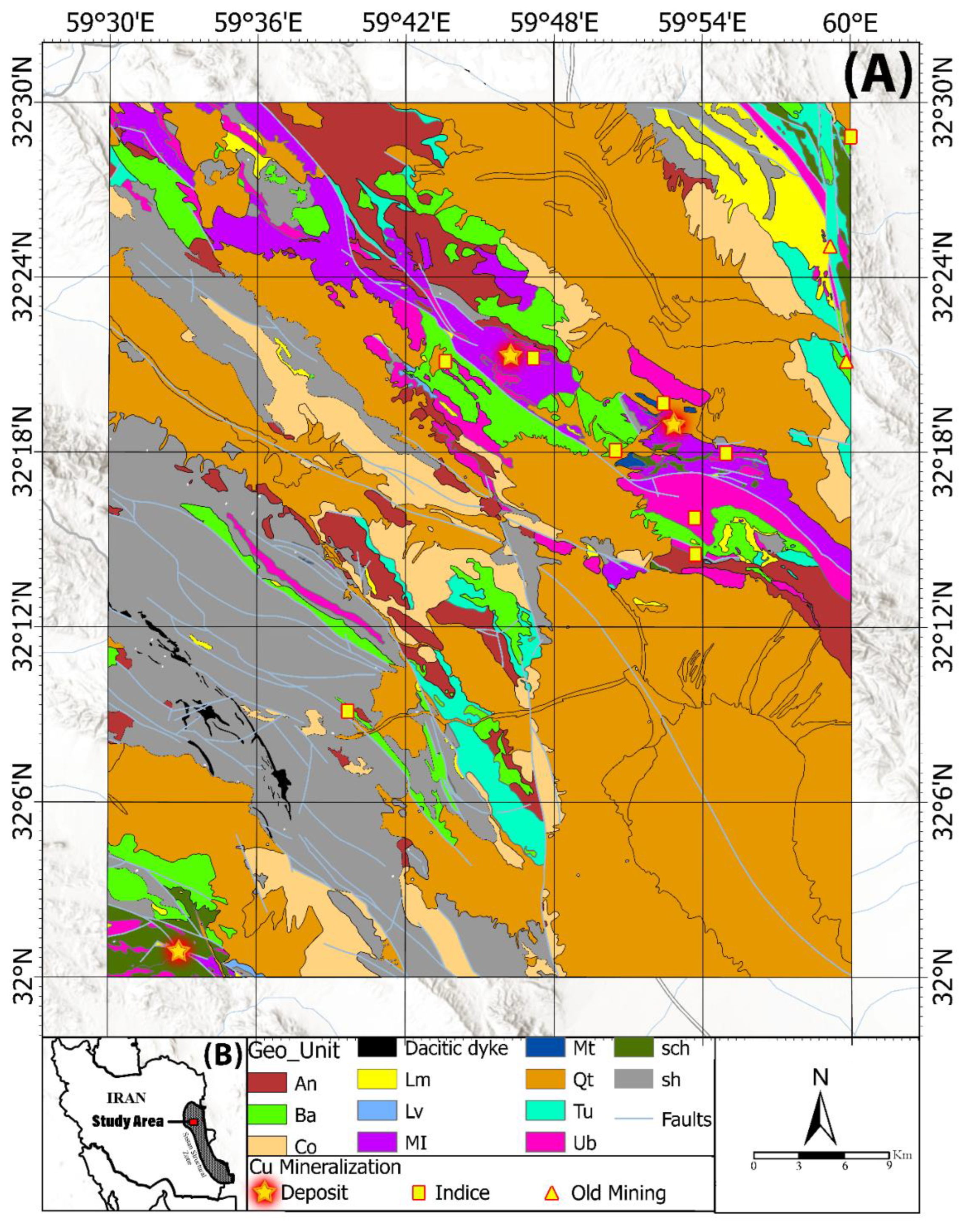
| Row | Copper Mineralization Name | Anomaly Center Coordinates | Anomaly Area (Km2) | Alteration | Lithology (Host Rock) | Cu Dominant Mineral | |
|---|---|---|---|---|---|---|---|
| Longitude (E) | Latitude (N) | ||||||
| 1 | Mesgaran Deposit | 59°52′49″ | 32°18′58′’ | 8 | Phy + Arg + Pp + Chl + Qtz | Ba + Anb | Cpy + Mch |
| 2 | Chah-Rasteh Deposit | 59°46′15″ | 32° 21′19″ | 4 | Phy + Arg + Pp + Chl + Cab | An + Anb | Ch + Mch |
| 3 | Zahri Deposit | 59°32′52″ | 32°00′50″ | 2 | Phy + Arg + Pp + Hem | Ub + Sch | Cpy + Ch + Mch |
| 4 | Kasrab Abandoned Mine | 59° 59′45″ | 32°21′05″ | 3.8 | Phy + Arg + Pp + Sep | Ub | Mch |
| 5 | Cheshme-Zangi Abandoned Mine | 59°59′08″ | 32°25′02″ | 2.5 | Phy + Arg + Pp + Silicification | Limestone shale + Listwanite | Cpy + Mch |
| 6 | Shir-Shotor Indice | 59°53′50″ | 32°14′28″ | 1 | Arg + Pp + Sep | An + Serpentinite (Ub) | Mch + Az |
| 7 | Dastgerd Indice | 59°43′39″ | 32°21′03″ | 2 | Arg + Pp + Sep + Hem | Harzburgite | Mch |
| 8 | Torshaab Indice | 59°59′56″ | 32°28′48″ | 5 | Phy + Arg + Pp + Hem + Lm | Sch | Mch + Az |
| 9 | Chah-Anjir Indice | 59°53′37″ | 32°15′44″ | 2 | Pp + Sep | Serpentinite (Ub) | Mch + Az |
| 10 | Zargaran Indice | 59°47′09″ | 32°21′14″ | 1 | Phy + Arg + Pp + Lm + Goe + Hem | An + Db | Mch + Az |
| 11 | West Mesgaran Indice | 59°52′26″ | 32°19′36″ | 1.5 | Arg + Pp + Hem + Lm | Mtd | Cpy + Mch + Az |
| 12 | Mirsimin Indice | 59° 54′58″ | 32°17′53″ | 9 | Arg + Pp + Hem | Db | Cpy + Mch + Az |
| 13 | Kuharod Indice | 59°50′31″ | 32°18′01″ | 1 | Phy + Arg + Pp + Hem | Db | Mch |
| 14 | Barghan Indice | 59° 39′38″ | 32°09′05″ | 2 | Arg + Pp + Lm + Geo + Hem | Db + Limestone | Mch |
| Communities | Background | Medium Intensity | High Intensity | ||||
|---|---|---|---|---|---|---|---|
| Sub-Communities | A | B | G | D | E | F | G |
| LF Threshold | Less than 12 | 12–15 | 15–22 | 22–26 | 26–30 | 30–41 | More than 41 |
| Distance from LF High-Intensity Community (Km) | Distance from Regional Faults (Km) | Copper Mineralization | Row |
|---|---|---|---|
| 1.9 | 1.1 | Mesgaran Deposit | 1 |
| 4.1 | 0.95 | Chah-Rasteh Deposit | 2 |
| 0.45 | Coincident | Zahri Deposit | 3 |
| 4.3 | Coincident | Kasrab Abandoned Mine | 4 |
| Coincident | Coincident | Cheshme-Zangi Abandoned Mine | 5 |
| 2.79 | Coincident | Shir-Shotor Indice | 6 |
| 3.67 | 1.64 | Dastgerd Indice | 7 |
| 1.8 | Coincident | Torshaab Indice | 8 |
| 1.52 | 0.8 | Chah-Anjir Indice | 9 |
| 3.5 | 1.49 | Zargaran Indice | 10 |
| 1.34 | 1.25 | West Mesgaran Indice | 11 |
| Coincident | Coincident | Mirsimin Indice | 12 |
| 1 | Coincident | Kuharod Indice | 13 |
| 1.59 | Coincident | Barghan Indice | 14 |
| 1.99 | 0.51 | Average Distance (Km) | |
Publisher’s Note: MDPI stays neutral with regard to jurisdictional claims in published maps and institutional affiliations. |
© 2022 by the authors. Licensee MDPI, Basel, Switzerland. This article is an open access article distributed under the terms and conditions of the Creative Commons Attribution (CC BY) license (https://creativecommons.org/licenses/by/4.0/).
Share and Cite
Shirazi, A.; Hezarkhani, A.; Pour, A.B. Fusion of Lineament Factor (LF) Map Analysis and Multifractal Technique for Massive Sulfide Copper Exploration: The Sahlabad Area, East Iran. Minerals 2022, 12, 549. https://doi.org/10.3390/min12050549
Shirazi A, Hezarkhani A, Pour AB. Fusion of Lineament Factor (LF) Map Analysis and Multifractal Technique for Massive Sulfide Copper Exploration: The Sahlabad Area, East Iran. Minerals. 2022; 12(5):549. https://doi.org/10.3390/min12050549
Chicago/Turabian StyleShirazi, Aref, Ardeshir Hezarkhani, and Amin Beiranvand Pour. 2022. "Fusion of Lineament Factor (LF) Map Analysis and Multifractal Technique for Massive Sulfide Copper Exploration: The Sahlabad Area, East Iran" Minerals 12, no. 5: 549. https://doi.org/10.3390/min12050549
APA StyleShirazi, A., Hezarkhani, A., & Pour, A. B. (2022). Fusion of Lineament Factor (LF) Map Analysis and Multifractal Technique for Massive Sulfide Copper Exploration: The Sahlabad Area, East Iran. Minerals, 12(5), 549. https://doi.org/10.3390/min12050549


