
Volumetric Quantification and Quality of Water Stored in a Mining Lake: A Case Study at Reocín Mine (Spain)


 ,
,  and
and
Abstract
1. Introduction
2. Materials and Methods
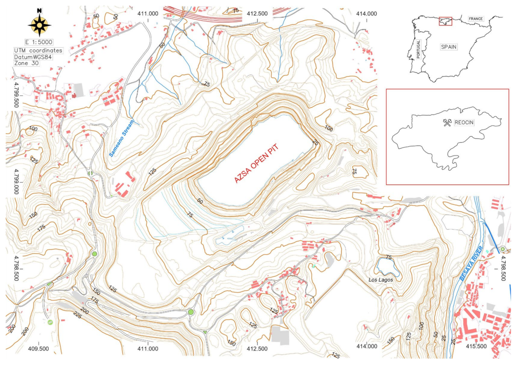
2.1. Study Area
2.1.1. Climatology
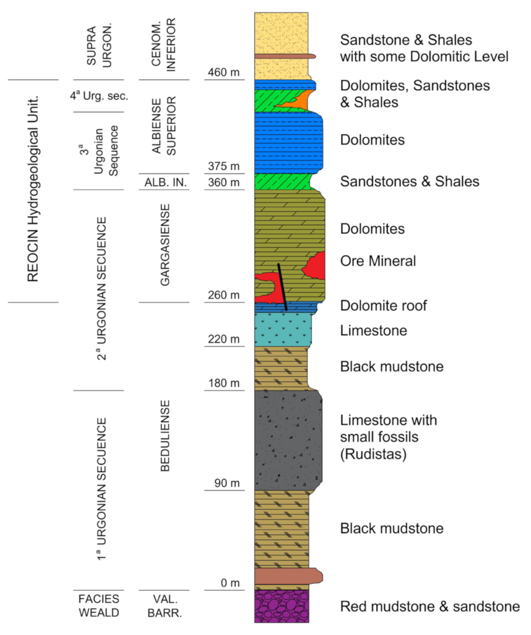
2.1.2. Geology
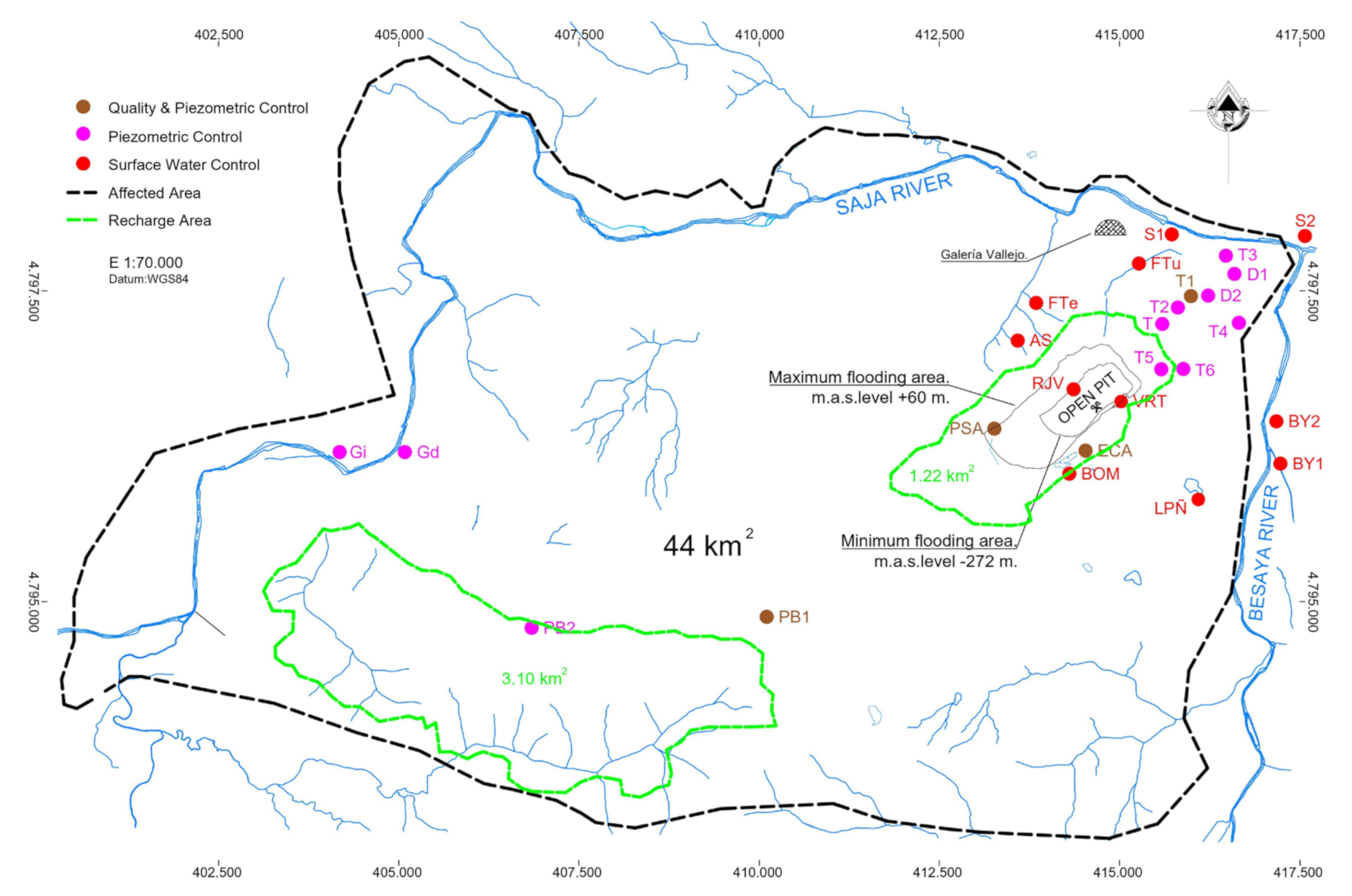
2.1.3. Hydrogeology
2.2. Methodology
2.2.1. Hydrogeochemical Karstic Aquifer Characterization
2.2.2. Pluviometric Study
2.2.3. Potential Mine Water Uses
3. Results and Discussions
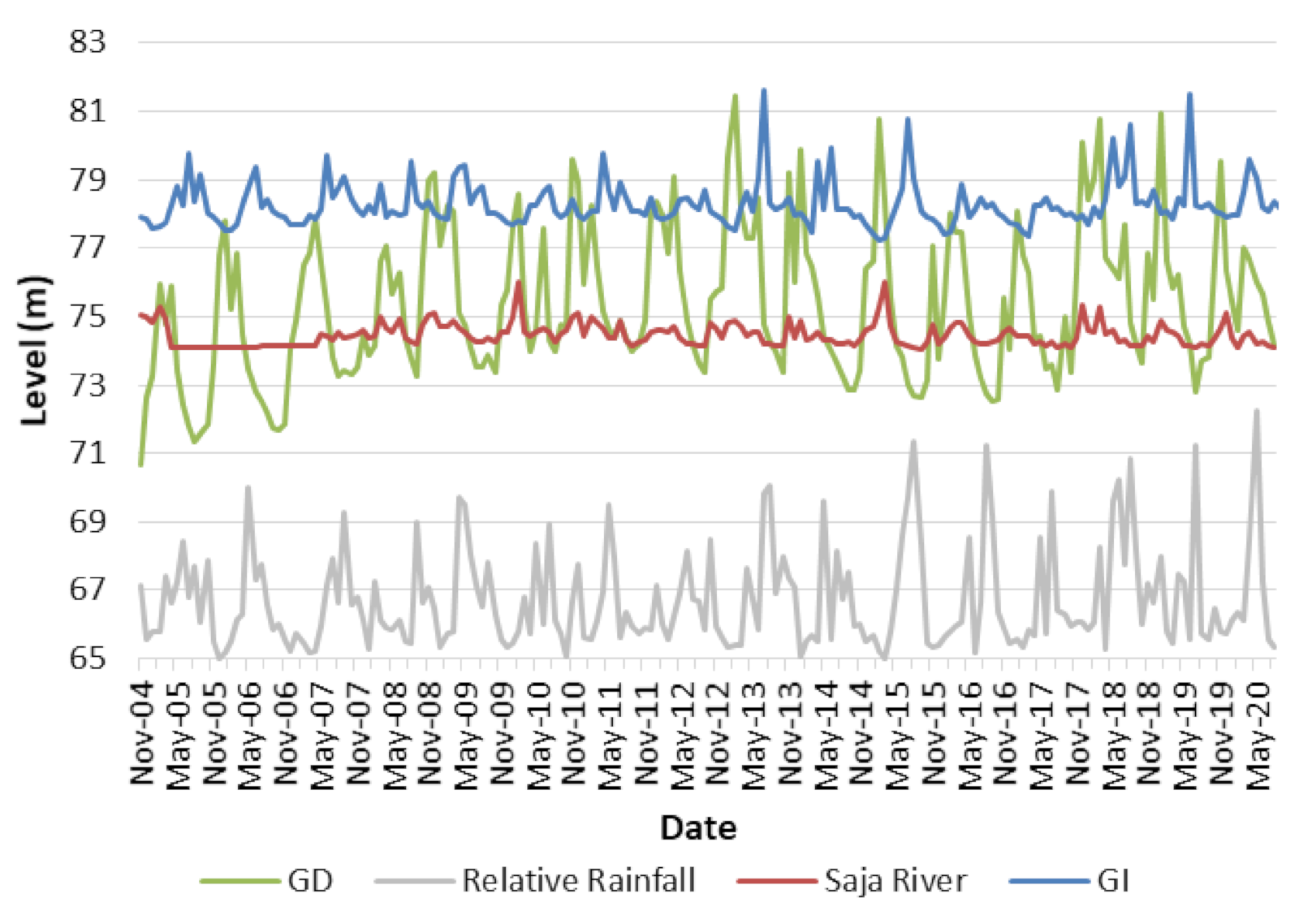
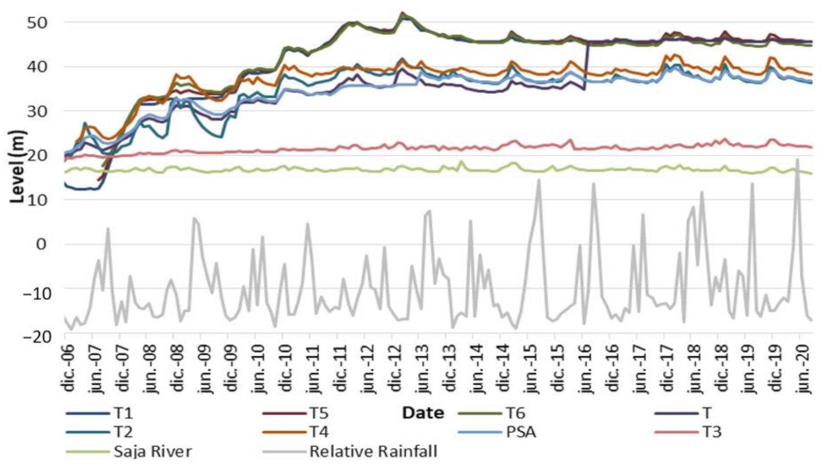
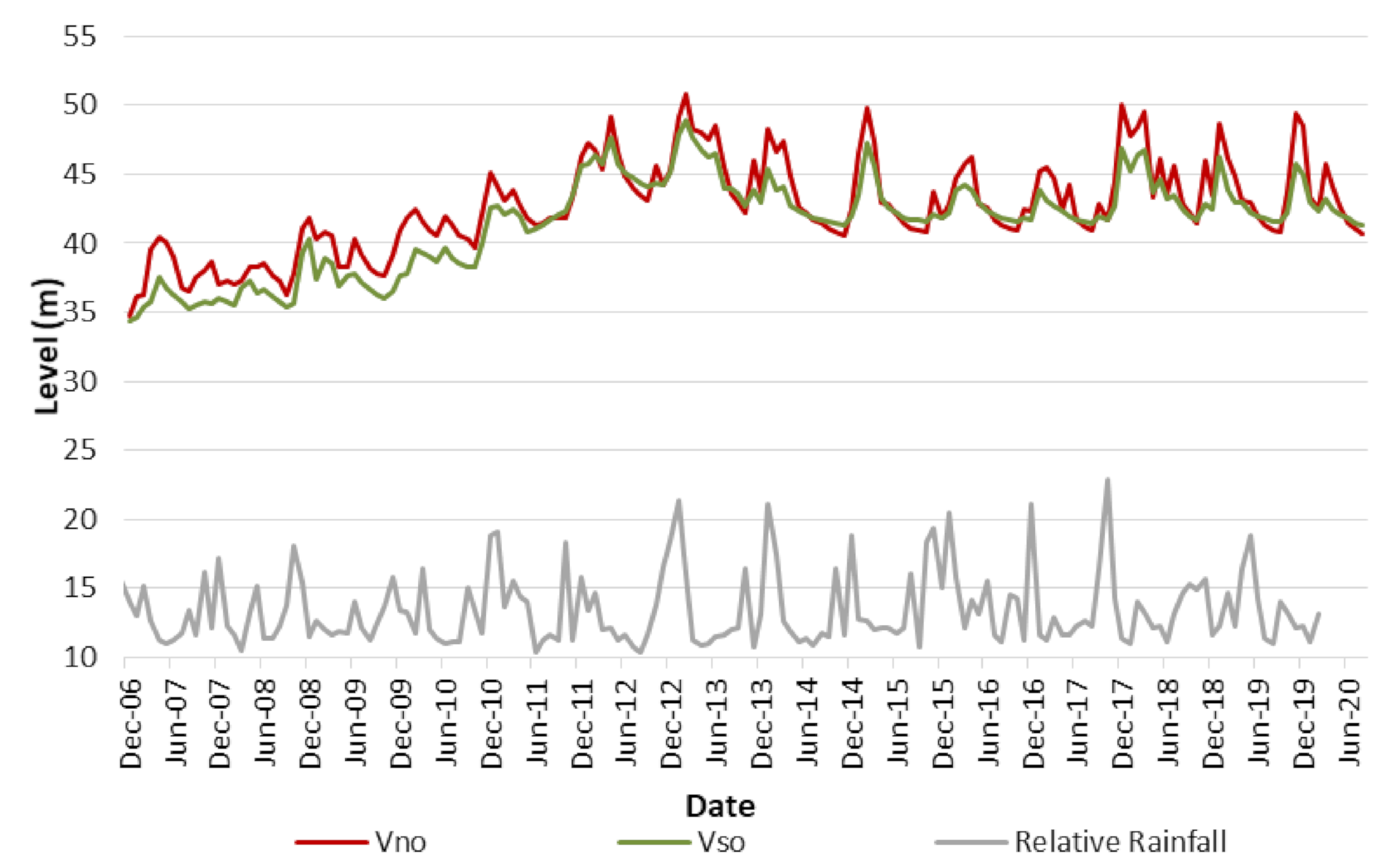
3.1. Hydrological Study
3.2. Pluviometric Study
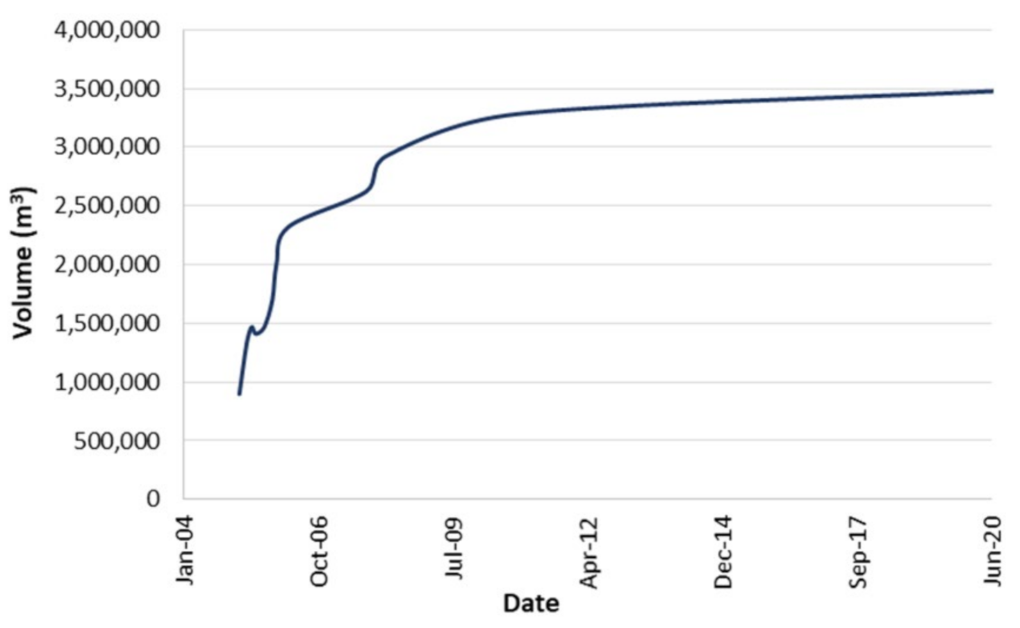
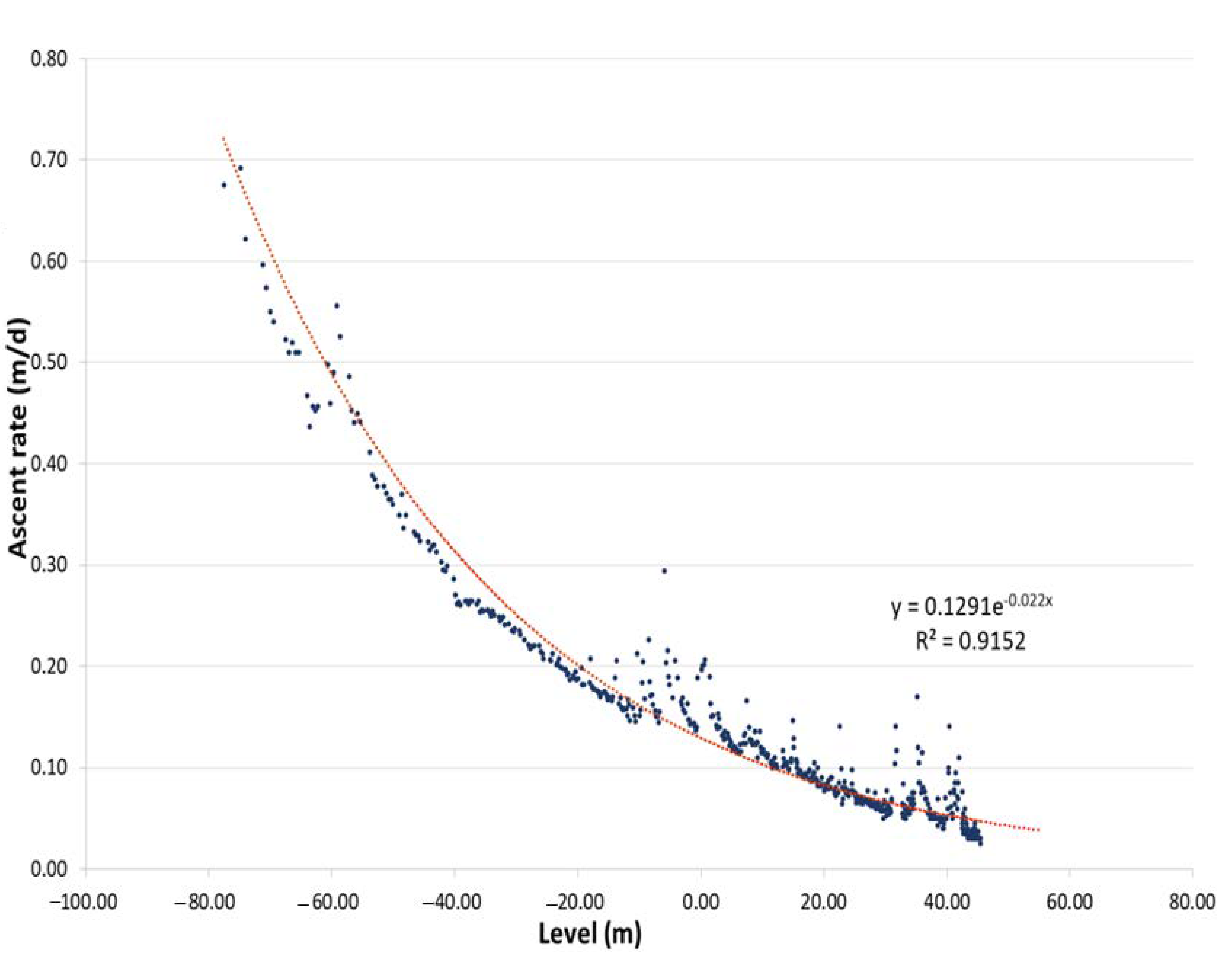
3.3. Void Volume Estimation
3.4. Potential Mine Water Uses
4. Conclusions
Author Contributions
Funding
Data Availability Statement
Acknowledgments
Conflicts of Interest
References
- Velasco, R.F.; Herrero, J.M.; Yusta, I.; Alonso, J.A.; Seebold, I.; Leach, D.L. Geology and geochemistry of the Reocin zinc–lead deposit, Basque– Cantabrian Basin, northern Spain. Econ. Geol. 2003, 98, 1371–1396. [Google Scholar] [CrossRef]
- Symons, D.T.; Lewchuk, M.T.; Kawasaki, K.; Velasco, F.; Leach, D.L. The Reocín zinc–lead deposit, Spain: Paleomagnetic dating of a late Tertiary ore body. Miner. Depos. 2009, 44, 867. [Google Scholar] [CrossRef]
- Pendás, F.; Cienfuegos, P.; García, R.; Cueva, J.M.; Pelayo, C.; Loredo, J. Consecuences of pumping cessation at Reocín Mine, Cantabria (Spain). In Water in Mining Environments, Proceedings of the IMWA Symposium, Cagliary, Italy, 27–31 May 2007; Cidu, R., Frau, F., Eds.; IMWA: Cagliari, Italy, 2007. [Google Scholar]
- Fernandez-Rubio, R.; Del Olmo, A.G. Mining drainage and water supply under sustainable constraints. In Proceedings of the IMWA: Water resources at risk, American Institute of Hydrology, Denver, CO, USA, 14–18 May 1995. [Google Scholar]
- Plata-Bedmar, A. Investigation of the origin of the water discharging at the Reocin Mine using isotope techniques. Isotope techniques in the study of the hydrology of fractured and fissured rocks. In Proceedings of the Advisory Group Meeting, IAEA, Vienna, Austria, 13–17 March 1989. [Google Scholar]
- Plata, A. Parameters of carbonate rock aquifers from tracer methods. Hydrogeological Processes in Karst Terranes. In Proceedings of the Antalya Symposium and Field Seminar, Antalya, Turkey, 7–17 October 1990. [Google Scholar]
- Finlayson, B.; Sauro, U. International cooperation in research on karst environments. Hydrogeological Processes in Karst Terranes. In Proceedings of the Antalya Symposium and Field Seminar, Antalya, Turkey, 7–17 October 1990. [Google Scholar]
- Fernandez-Rubio, R.; Lorca, D.F. Mine water drainage. Mine Water Environ. 1993, 12, 107–130. [Google Scholar] [CrossRef]
- Trilla, J.; López, C.F.; Peón, A. Sobre el origen y dinámica de las aguas fluyentes de las explotaciones minerales de Reocín (Santander, España). In Proceedings of the Water Mining and Undergound World Congress (SIAMOS-78), Granada, Spain, 18–22 September 1978; pp. 293–307. [Google Scholar]
- Fernández, G.; Reinoso, J.; Fernández, G. El karst de la mina de Reocín: Un problema hidrológico. In Jornadas Sobre Tecnología del Agua en la Minería; IGME: Madrid, Spain, 1992; pp. 31–54. [Google Scholar]
- Fernández-Rubio, R. Investigations about the origin of water inflow at Reocin Mine (Santander, Spain). In Proceedings of the 1st International Mine Water Congress, Budapest, Hungary, 19–24 April 1982; pp. 101–120. [Google Scholar]
- Reutilización turística del patrimonio minero de Cantabria. Cuadernos de Turismo 2009, 23, 69–88.
- Ley de Minas 22/1973, por el que se Establece el régimen jurídico de la Investigación y Aprovechamiento de los Yacimientos Minerales y demás Recursos Geológicos. BOE 176. Available online: http://www.cma.gva.es/admon/normativa/legislacion/legis/001001000360.html (accessed on 17 February 2021).
- Real Decreto 975/2009, de 12 de junio, Sobre gestión de los Residuos de las Industrias Extractivas y de Protección y Rehabilitación del Espacio Afectado por Actividades Mineras. BOE 143. Available online: https://www.boe.es/buscar/doc.php?id=BOE-A-2009-9841 (accessed on 17 February 2021).
- Juncosa, R.; Delgado, J.; Padilla, F.; Rodríguez-Vellando, P.; Hernández, H. Improvements in Mero River Watershed Water Supply Regulation Through Integration of a Mining Pit Lake as a Water Supply Source. Mine Water Environ. 2016, 35, 389–397. [Google Scholar] [CrossRef]
- Manual de Restauración de minas a cielo abierto; Asociación Nacional de Empresarios fabricantes de Áridos ANEFA, Gobierno de La Rioja. Consejería de Turismo, Medio Ambiente y Política Territorial, Dirección General de Política Territorial: Logroño, Spain, 2006.
- Sena, C.; Molinero, J. Water Resources Assessment and Hydrogeological Modelling as a Tool for the Feasibility Study of a Closure Plan for an Open Pit Mine (La Respina Mine, Spain). Mine Water Environ. 2009, 28, 94–101. [Google Scholar] [CrossRef]
- Fontaine, R.C.; Davis, A.; Fennemore, G.G. The comprehensive realistic yearly pit transient infilling code (CRYPTIC): A novel pit lake analytical solution. Mine Water Environ. 2003, 22, 187–193. [Google Scholar] [CrossRef]
- Banks, S.B.; Banks, D. Abandoned mines drainage: Impact assessment and mitigation of discharges from coal mines in the UK. Eng. Geol. 2001, 60, 31–37. [Google Scholar] [CrossRef]
- McCullough, C.D.; Lund, M.A. Opportunities for Sustainable Mining Pit Lakes in Australia. Mine Water Environ. 2007, 25, 220–226. [Google Scholar] [CrossRef]
- McCullough, C.D.; Schultze, M.; Vandenberg, J. Realizing Beneficial End Uses from Abandoned Pit Lakes. Minerals 2020, 10, 133. [Google Scholar] [CrossRef]
- Czegka, W.; Junge, F.W. Zwenkau: The genesis from a lignite open cast mine to a recreation lake. Hydro-and geochemical impacts. SDGG 2007, 81–83. [Google Scholar]
- Schultze, M.; Geller, W. Filling and management of pit lakes with diverted river water and with mine water-German experiences. In Mine Pit Lakes: Closure and Management, 1st ed.; ACG Australian Centre for Geomechanics: Nedlands, Australia, 2011; pp. 107–120. [Google Scholar]
- Hinwood, A.; Heyworth, J.; Tanner, H.; Mccullough, C.D. Recreational Use of Acidic Pit Lakes—Human Health Considerations for Post Closure Planning. J. Water Resour. Prot. 2012, 4, 1061–1070. [Google Scholar] [CrossRef]
- Juncosa, R.; Delgado, J.; Cereijo, J.L.; Muñoz, A. Hydrochemical Evolution of the filling of the Mining Lake of As Pontes (Spain). Mine Water Environ. 2019, 38, 556–565. [Google Scholar] [CrossRef]
- Preene, M.; Younger, P.L. Can you take the heat? Geothermal energy in mining. Mining Technol. 2014, 123, 107–118. [Google Scholar] [CrossRef]
- Banks, D. An Introduction to Thermogeology: Ground Source Heating and Cooling, 2nd ed.; Wiley: Chichester, UK, 2012; pp. 133–149. [Google Scholar]
- Raymond, J.; Therrien, R. Optimizing the design of a geothermal district heating and cooling system located at a flooded mine in Canada. Hydrogeol. J. 2014, 22, 217–231. [Google Scholar] [CrossRef]
- Banks, D.; Steven, J.; Berry, J.; Burnside, N.; Boyce, A. A combined pumping test and heat extraction/recirculation trial in an abandoned hematite ore mine shaft, Egremont, Cumbria, UK. Water Resour. Manag. 2019, 5, 51–69. [Google Scholar]
- Watzlaf, G.R.; Ackman, T.E. Underground mine water for heating and cooling using geothermal heat pump systems. Mine Water Environ. 2006, 25, 1–14. [Google Scholar] [CrossRef]
- Malolepszy, Z.; Demollin-Schneiders, E.; Bowers, D. Potential use of geothermal mine waters in Europe. In Proceedings of the World Geothermal Congress, Antalya, Turkey, 24–29 April 2005; pp. 24–29. [Google Scholar]
- Loredo, J.; Ordóñez, A.; Jardón, S.; Álvarez, R. Mine water as geothermal resource in Asturian coal mining watersheds (NW Spain). In Proceedings of the IMWA Congress 2011 Mine Water—Managing The Challenges, Aachen, Germany, 4–11 September 2011; Rüde, R.T., Freund, A., Wolkersdorfer, C., Eds.; IMWA: Aachen, Germany, 2011; pp. 177–181. [Google Scholar]
- López-Pamo, E.; Sánchez-España, J.; Santofimia, E.; Reyes, J.; Martín-Rubí, J.A. Limnología físico-química del lago formado Durante la Inundación de la Corta de Reocín, Cantabria; Unpublic Report; Instituto Geológico y Minero de España (IGME), Ministerio de Ciencia e Innovación: Madrid, Spain, 2010.
- Eary, L.E. Predicting the effects of evapoconcentration on water quality in mine pit lakes. J. Geochem. Explorat. 1998, 64, 223–236. [Google Scholar] [CrossRef]
- Boente, C.; Martín-Méndez, I.; Bel-Lan, A.; Gallego, J.R. A novel and synergistic geostatistical approach to identify sources and cores of Potentially Toxic Elements in soils: An application in the region of Cantabria (Northern Spain). J. Geochem. Explorat. 2020, 208, 106397. [Google Scholar] [CrossRef]
- Hamdi, E.; Du Mouza, J.; Fleurisson, J.A. Evaluation of the part of blasting energy used for rock mass fragmentation. Fragblast 2001, 5, 180–193. [Google Scholar] [CrossRef]
- Fernández, P. Propuesta de Valorización del Patrimonio Minero de Reocín, Cantabria. Master’s Thesis, University of Cantabria, Cantabria, Spain, June 2016. [Google Scholar]
- Fernández, J.R.; Alonso, J.A.; Loredo, J.L. La inundación de la mina de Reocín. In Investigación y Gestión de los Recursos del Subsuelo; López-Geta, J.A., Loredo, J., Fernández, L., Pernía, J.M., Eds.; IGME: Madrid, Spain, 2008; pp. 389–405. [Google Scholar]
- Rouch, R.; (CNRS, Paris, France); Gourbault, N.; (CNRS, Paris, France). Etude de la Derive des Animaux dans les eaux de la mine de Reocín (Torrelavega-Santander-Espagne). Personal communication. 1980. [Google Scholar]
- Fernández, R.; (FRASA Ingenieros Consultores, Madrid, Spain). Estudio Hidrogeológico del Sinclinal de Santillana (Cantabria) Relacionado con el cese de Bombeo del agua de la mina de Reocín. Personal communication. 2004. [Google Scholar]
- Ford, D.C.; Williams, P.W. Karst Geomorphology and Hydrology, 2nd ed.; John Wiley & Sons: Chichester, UK, 2007. [Google Scholar]
- Fernández, R.; Baquero, J.C.; Lorca, D.; Verdejo, J. Hidrogeología de la mina de Reocín. In Investigación y Gestión de los Recursos del Subsuelo; López-Geta, J.A., Loredo, J., Fernández, L., Pernía, J.M., Eds.; IGME: Madrid, Spain, 2008; pp. 423–455. [Google Scholar]
- Castro, J.; Moore, J. Pit lakes: Their characteristics and the potential for their remediation. Environ. Geol. 2000, 39, 1254–1260. [Google Scholar] [CrossRef]
- White, W.B. Karst hydrology: Recent developments and open questions. Eng. Geol. 2002, 65, 85–105. [Google Scholar] [CrossRef]
- Pisabarro, A.; Pellitero, R.; Serrano, E.; Gómez-Lende, M.; González-Trueba, J.J. Ground temperatures, landforms and processes in an Atlantic mountain. Cantabrian Mountains (Northern Spain). Catena 2017, 149, 623–636. [Google Scholar] [CrossRef]
- Bruschi, V.M.; Bonachea, J.; Remondo, J.; Gómez-Arozamena, J.; Rivas, V.; Méndez, G.; Cendrero, A. Analysis of geomorphic systems’ response to natural and human drivers in northern Spain: Implications for global geomorphic change. Geomorphology 2013, 196, 267–279. [Google Scholar] [CrossRef]
- Grandia, F.; Canals, À.; Cardellach, E.; Banks, D.A.; Perona, J. Origin of ore-forming brines in sediment-hosted Zn-Pb deposits of the Basque-Cantabrian Watershed, Northern Spain. Econ. Geol. 2003, 98, 1397–1411. [Google Scholar] [CrossRef]
- Yue, S.; Ouarda, T.B.M.J.; Bobée, B.; Legendre, P.; Bruneau, P. The Gumbel mixed model for flood frequency analysis. J. Hydrol. 2000, 228, 3–4. [Google Scholar] [CrossRef]
- APHA. Standard Methods for the Examination of Water and Wastewater, 20th ed.; American Public Health Association; American Water Works Association; Water Environment Federation: Washington, DC, USA, 2005. [Google Scholar]
- Álvarez, R.; Ordoñez, A.; De Miguel, E.; Loredo, C. Prediction of the flooding of a mining reservoir in NW Spain. J. Environ. Manage. 2016, 184, 219–228. [Google Scholar] [CrossRef]
- Hrdinka, T. Typology and potential utilization of anthropogenic lakes in mining pits in the Czech Republic. Limnol. Rev. 2005, 7, 47–53. [Google Scholar]
- Nixdorf, B.; Lessmann, D.; Deneke, R. Mining lakes in a disturbed landscape: Application of the EC Water Framework Directive and future management strategies. Ecol. Eng. 2005, 24, 67–73. [Google Scholar] [CrossRef]
- Gammons, C.H.; Harris, L.N.; Castro, J.M.; Cott, P.A.; Hanna, B.W. Creating lakes from open pit mines: Processes and considerations, with emphasis on northern environments. Canad. Tech. Rep. Fish. Aq. Sci. 2009, 8, 1–106. [Google Scholar]
- Ordoñez, A.; Jardón, S.; Álvarez, R.; Andrés, C.; Pendás, F. Hydrogeological definition and applicability of abandoned coal mines as water reservoirs. J. Environ. Monit. 2012, 14, 2127–2136. [Google Scholar] [CrossRef]
- Doupé, R.G.; Lymbery, A.J. Environmental risks associated with beneficial end uses of mine lakes in southwestern Australia. Mine Water Environ. 2005, 24, 134–138. [Google Scholar] [CrossRef]
- Real Decreto 140/2003, por el que se Establecen los Criterios Sanitarios de la Calidad del agua de Consumo Humano. BOE 45 (Sec. 1). pp. 7228–7245. Available online: https://www.boe.es/boe/dias/2003/02/21/pdfs/A07228-07245.pdf (accessed on 17 February 2021).
- Akcil, A.; Koldas, S. Acid Mine Drainage (AMD): Causes, treatment and case studies. J. Clean. Prod. 2006, 14, 1139–1145. [Google Scholar] [CrossRef]
- Valenzuela, P.; Domínguez-Cuesta, M.J.; Meléndez-Asensio, M.; Jiménez-Sánchez, M.; de Santa María, J.A.S. Active sinkholes: A geomorphological impact of the Pajares tunnels (Cantabrian range, NW Spain). Eng. Geol. 2015, 196, 158–170. [Google Scholar] [CrossRef]
- Unsal, B.; Yazicigil, H. Assessment of Open Pit Dewatering Requirements and Pit Lake Formation for the Kışladağ Gold Mine, Uşak, Turkey. Mine Water Environ. 2016, 35, 180–198. [Google Scholar] [CrossRef]
- Instituto Nacional de Estadística. Demografía y Población. Available online: http://www.ine.es/dyngs/INEbase/es/categoria.htm?c=Estadistica_P&cid=1254734710984 (accessed on 15 June 2020).
- Hamm, V.; Sabet, B. Modelling of fluid flow and heat transfer to assess the geothermal potential of a flooded coal mine in Lorraine, France. Geothermics 2010, 39, 177–186. [Google Scholar] [CrossRef]
- Rybach, L. Geothermal energy: Sustainability and the environment. Geothermics 2003, 32, 463–470. [Google Scholar] [CrossRef]
- Pujades, E.; Orban, P.; Bodeux, S.; Archambeau, P.; Erpicum, S.; Dassargues, A. Underground pumped storage hydropower plants using open pit mines: How do groundwater exchanges influence the efficiency? Appl. Energy 2017, 190, 135–146. [Google Scholar] [CrossRef]
- Wessel, M.; Madlener, R.; Hilgers, C. Economic feasibility of semi-underground pumped storage hydropower plants in open-pit mines. Energies 2020, 13, 4178. [Google Scholar] [CrossRef]
- Pujades, E.; Willems, T.; Bodeux, S.; Orban, P.; Dassargues, A. Underground pumped storage hydroelectricity using abandoned works (deep mines or open pits) and the impact on groundwater flow. Hydrogeol. J. 2016, 24, 1531–1546. [Google Scholar] [CrossRef]
- Kitsikoudis, V.; Archambeau, P.; Dewals, B.; Pujades, E.; Orban, P.; Dassargues, A.; Erpicum, S. Underground pumped-storage hydropower (UPSH) at the Martelange Mine (Belgium): Underground reservoir hydraulics. Energies 2020, 13, 3512. [Google Scholar] [CrossRef]


| ZONE | NAME | DEPTH (m) |
|---|---|---|
| WEST | Golbardo Izquierda (GI) | 86 |
| Saja River under Golbardo bridge | 85 | |
| Golbardo derecha (GD) | 98 | |
| El Burco 1 | 217 | |
| El Burco 2 | 203 | |
| Pozo Santa Amelia (PSA) | 108 | |
| EAST | Torres (T) | 100 |
| Torres 1 (T1) | 54 | |
| Torres 2 (T2) | 32 | |
| Torres 3 (T3) | 38 | |
| Torres 4 (T4) | 38 | |
| Torres 5 (T5) | 100 | |
| Torres 6 (T6) | 92 | |
| Saja River under Ganzo bridge | 29 | |
| Galería Vallejo | North (Vno) | 56 |
| South (Vso) | 56 |
Publisher’s Note: MDPI stays neutral with regard to jurisdictional claims in published maps and institutional affiliations. |
© 2021 by the authors. Licensee MDPI, Basel, Switzerland. This article is an open access article distributed under the terms and conditions of the Creative Commons Attribution (CC BY) license (http://creativecommons.org/licenses/by/4.0/).
Share and Cite
Barral, N.; Husillos, R.; Castillo, E.; Cánovas, M.; Lam, E.J.; Calvo, L. Volumetric Quantification and Quality of Water Stored in a Mining Lake: A Case Study at Reocín Mine (Spain). Minerals 2021, 11, 212. https://doi.org/10.3390/min11020212
Barral N, Husillos R, Castillo E, Cánovas M, Lam EJ, Calvo L. Volumetric Quantification and Quality of Water Stored in a Mining Lake: A Case Study at Reocín Mine (Spain). Minerals. 2021; 11(2):212. https://doi.org/10.3390/min11020212
Chicago/Turabian StyleBarral, Noemí, Raúl Husillos, Elena Castillo, Manuel Cánovas, Elizabeth J. Lam, and Lucas Calvo. 2021. "Volumetric Quantification and Quality of Water Stored in a Mining Lake: A Case Study at Reocín Mine (Spain)" Minerals 11, no. 2: 212. https://doi.org/10.3390/min11020212
APA StyleBarral, N., Husillos, R., Castillo, E., Cánovas, M., Lam, E. J., & Calvo, L. (2021). Volumetric Quantification and Quality of Water Stored in a Mining Lake: A Case Study at Reocín Mine (Spain). Minerals, 11(2), 212. https://doi.org/10.3390/min11020212