Quality of Peri-Urban Soil Developed from Ore-Bearing Carbonates: Heavy Metal Levels and Source Apportionment Assessed Using Pollution Indices

 ,
,
Abstract
1. Introduction
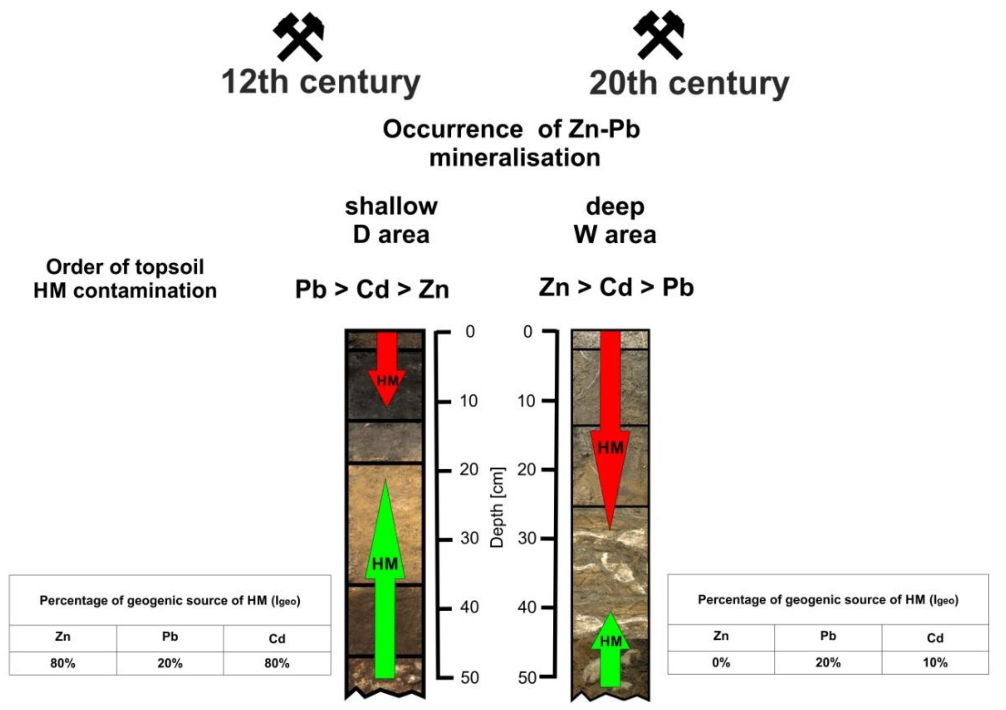
2. Study Area
3. Material and Analytical Methods
4. Soil Pollution Assessment
5. Results and Discussion
6. Conclusions
Supplementary Materials
Author Contributions
Funding
Acknowledgments
Conflicts of Interest
References
- Norgate, T.E.; Jahanshahi, S.; Rankin, W.J. Assessing the environmental impact of metal production processes of metal production processes. J. Clean. Prod. 2007, 15, 838–848. [Google Scholar] [CrossRef]
- Chrastný, V.; Vaněk, A.; Teper, L.; Cabala, J.; Procházka, J.; Pechar, L.; Drahota, P.; Penížek, V.; Komárek, M.; Novák, M. Geochemical position of Pb, Zn and Cd in soils near the Olkusz mine/smelter, South Poland: Effects of land use, type of contamination and distance from pollution source. Environ. Monit. Assess. 2012, 184, 2517–2536. [Google Scholar] [CrossRef]
- Vaněk, A.; Chrastný, V.; Komárek, M.; Penížek, V.; Teper, L.; Cabala, J.; Drábek, O. Geochemical position of thallium in soils from a smelter-impacted area. J. Geochem. Explor. 2013, 124, 176–182. [Google Scholar] [CrossRef]
- Kalinovic, T.S.; Serbula, S.M.; Radojevic, A.A.; Kalinovic, J.V.; Steharnik, M.M.; Petrovic, J.V. Elder, linden and pine biomonitoring ability of pollution emitted from the copper smelter and the tailings ponds. Geoderma 2016, 262, 266–275. [Google Scholar] [CrossRef]
- Ghayoraneh, M.; Qishlaqi, A. Concentration, distribution and speciation of toxic metals in soils along a transect around a Zn/Pb smelter in the northwest of Iran. J. Geochem. Explor. 2017, 180, 1–14. [Google Scholar] [CrossRef]
- Varol, M. Assessment of heavy metal contamination in sediments of the Tigris River (Turkey) using pollution indices and multivariate statistical techniques. J. Hazard. Mater. 2011, 195, 355–364. [Google Scholar] [CrossRef] [PubMed]
- Ogbeibu, A.E.; Omoigberale, M.O.; Ezenwa, I.M.; Eziza, J.O.; Igwe, J.O. Using pollution load index and geoaccumulation index for the assessment of heavy metal pollution and sediment quality of the Benin River, Nigeria. Nat. Environ. 2014, 2, 1–9. [Google Scholar] [CrossRef]
- Loska, K.; Wiechuła, D.; Korus, I. Metal contamination of farming soils affected by industry. Environ. Int. 2004, 30, 159–165. [Google Scholar] [CrossRef]
- Diatta, J.B.; Chudzinska, E.; Wirth, S. Assessment of heavy metal contamination of soils impacted by a zinc smelter activity. J. Elementol. 2008, 13, 5–16. [Google Scholar]
- Li, Z.; Ma, Z.; van der Kuijp, T.J.; Yuan, Z.; Huang, L. A review of soil heavy metal pollution from mines in China: Pollution and health risk assessment. Sci. Total Environ. 2014, 468–469, 843–853. [Google Scholar] [CrossRef]
- Dziubanek, G.; Piekut, A.; Rusin, M.; Baranowska, R.; Hajok, I. Contamination of food crops grown on soils with elevated heavy metals content. Ecotoxicol. Environ. Saf. 2015, 118, 183–189. [Google Scholar] [CrossRef] [PubMed]
- Ettler, V. Soil contamination near non-ferrous metal smelters: A review. Appl. Geochem. 2016, 64, 56–74. [Google Scholar] [CrossRef]
- Nouri, M.; Haddioui, A. Assessment of metals contamination and ecological risk in ait Ammar abandoned iron mine soil, Morocco. Ekológia 2016, 35, 32–49. [Google Scholar] [CrossRef]
- Obiora, S.C.; Chukwu, A.; Davies, T.C. Heavy metals and health risk assessment of arable soils and food crops around Pb-Zn mining localities in Enyigba, southeastern Nigeria. J. Afr. Earth Sci. 2016, 116, 182–189. [Google Scholar] [CrossRef]
- Xue, S.; Shi, L.; Wu, C.; Wu, H.; Qin, Y.; Pan, W.; Hartley, W.; Cui, M. Cadmium, lead, and arsenic contamination in paddy soils of a mining area and their exposure effects on human HEPG2 and keratinocyte cell-lines. Environ. Res. 2017, 156, 23–30. [Google Scholar] [CrossRef] [PubMed]
- Liu, J.; Wang, J.; Xiao, T.; Bao, Z.; Lippold, H.; Luo, X.; Yin, M.; Ren, J.; Chen, Y.; Linghu, W. Geochemical dispersal of thallium and accompanying metals in sediment profiles from a smelter-impacted area in South China. Appl. Geochem. 2018, 88, 239–246. [Google Scholar] [CrossRef]
- Wu, J.; Long, J.; Liu, L.; Li, J.; Liao, H.; Zhang, M.; Zhao, C.; Wu, Q. Risk assessment and source identification of toxic metals in the agricultural soil around a Pb/Zn mining and smelting area in Southwest China. Int. J. Environ. Res. Public Health 2018, 15, 1838. [Google Scholar] [CrossRef]
- Wiggenhauser, M.; Bigalke, M.; Imseng, M.; Müller, M.; Keller, A.; Murphy, K.; Kreissig, K.; Rehkämper, M.; Wilcke, W.; Frossard, E. Cadmium isotope fractionation in soil-wheat systems. Environ. Sci. Technol. 2016, 50, 9223–9231. [Google Scholar] [CrossRef]
- Dinis, L.; Savard, M.M.; Gammon, P.; Bégin, C.; Vaive, J. Influence of climatic conditions and industrial emissions on spruce tree-ring Pb isotopes analyzed at ppb concentrations in the Athabasca oil sands region. Dendrochronologia 2016, 37, 96–106. [Google Scholar] [CrossRef]
- Wei, X.; Lyu, S.; Yu, Y.; Wang, Z.; Liu, H.; Pan, D.; Chen, J. Phylloremediation of air pollutants: Exploiting the potential of plant leaves and leaf-associated microbes. Front. Plant Sci. 2017, 28, 1318. [Google Scholar] [CrossRef]
- Liu, J.; Wei, X.; Zhou, Y.; Tsang, D.C.W.; Bao, Z.; Yin, M.; Lippold, H.; Yuan, W.; Wang, J.; Feng, Y.; et al. Thallium contamination, health risk assessment and source apportionment in common vegetables. Sci. Total Environ. 2020, 703, 135547. [Google Scholar] [CrossRef] [PubMed]
- Wang, J.; Jiang, Y.; Sun, J.; She, J.; Yin, M.; Fang, F.; Xiao, T.; Song, G.; Liu, J. Geochemical transfer of cadmium in river sediments near a lead-zinc smelter. Ecotoxicol. Environ. Saf. 2020, 196, 110529. [Google Scholar] [CrossRef] [PubMed]
- Durkalec, M.; Szkoda, J.; Kolacz, R.; Opalinski, S.; Nawrocka, A.; Zmudzki, J. Bioaccumulation of Lead, Cadmium and Mercury in Roe Deer and Wild Boars from areas with different levels of toxic metal pollution. Int. J. Environ. Res. 2015, 9, 205–212. [Google Scholar] [CrossRef]
- Kapusta, P.; Sobczyk, Ł. Effects of heavy metal pollution from mining and smelting on enchytraeid communities under different land management and soil conditions. Sci. Total Environ. 2015, 536, 517–526. [Google Scholar] [CrossRef]
- Weissmannová, H.D.; Pavlovský, J. Indices of soil contamination by heavy metals—Methodology of calculation for pollution assessment (minireview). Environ. Monit. Assess. 2017, 189, 616. [Google Scholar] [CrossRef]
- Barbieri, M. The importance of enrichment factor (EF) and geoaccumulation index (Igeo) to evaluate the soil contamination. J. Geol. Geophys. 2016, 5, 237. [Google Scholar] [CrossRef]
- Baran, A.; Wieczorek, J. Application of geochemical and ecotoxicity indices for assessment of heavy metals content in soils. Arch. Environ. Prot. 2015, 41, 54–63. [Google Scholar] [CrossRef]
- Baran, A.; Wieczorek, J.; Mazurek, R.; Urbański, K.; Klimkowicz-Pawlas, A. Potential ecological risk assessment and predicting zinc accumulation in soils. Environ. Geochem. Health 2018, 40, 435–450. [Google Scholar] [CrossRef]
- Wieczorek, J.; Baran, A.; Urbański, K.; Mazurek, R.; Klimowicz-Pawlas, A. Assessment of the pollution and ecological risk of lead and cadmium in soils. Environ. Geochem. Health 2018, 40, 2325–2342. [Google Scholar] [CrossRef]
- Zang, Z.; Li, Y.; Li, H.; Guo, Z.; Zhang, R. Spatiotemporal variation and pollution assessment of Pb/Zn from smelting activities in China. Int. J. Environ. Res. Public Health 2020, 17, 1968. [Google Scholar] [CrossRef]
- Mazurek, R.; Kowalska, J.B.; Gąsiorek, M.; Zadrożny, P.; Wieczorek, J. Pollution indices as comprehensive tools for evaluation of the accumulation and provenance of potentially toxic elements in soils in Ojców National Park. J. Geochem. Explor. 2019, 201, 13–30. [Google Scholar] [CrossRef]
- Blaser, P.; Zimmermann, S.; Luster, J.; Shotyk, W. Critical examination of trace element enrichments and depletions in soils: As, Cr, Cu, Ni, Pb, and Zn in Swiss forest soils. Sci. Total Environ. 2000, 249, 257–280. [Google Scholar] [CrossRef]
- Desaules, A. Critical evaluation of soil contamination assessment methods for trace metals. Sci. Total Environ. 2012, 426, 120–131. [Google Scholar] [CrossRef]
- Wu, J.; Teng, Y.; Lu, S.; Wang, Y.; Jiao, X. Evaluation of soil contamination indices in a mining area of Jiangxi, China. PLoS ONE 2014, 9, e112917. [Google Scholar] [CrossRef]
- Maanan, M.; Saddik, M.; Maanan, M.; Chaibi, M.; Assobhei, O.; Zourarah, B. Environmental and ecological risk assessment of heavy metals in sediments of Nador lagoon, Morocco. Ecol. Indic. 2015, 48, 616–626. [Google Scholar] [CrossRef]
- Rachwał, M.; Kardel, K.; Magiera, T.; Bens, O. Application of magnetic susceptibility in assessment of heavy metal contamination of Saxonian soil (Germany) caused by industrial dust deposition. Geoderma 2017, 295, 10–21. [Google Scholar] [CrossRef]
- Leach, D.L.; Viets, J.G.; Powell, J.W. Textures of ores from the Silesian-Cracow zinc-lead deposits, Poland: Clues to the ore-forming environment. Pol. Geol. Inst. Pap. 1996, 154, 37–50. [Google Scholar]
- Szuwarzynski, M. Ore bodies in the Silesian-Cracow Zn-Pb ore district, Poland. Pol. Geol. Inst. Pap. 1996, 154, 9–24. [Google Scholar]
- Górecka, E. Mineral sequence development in the Zn-Pb deposits of the Silesian-Cracow area, Poland. Pol. Geol. Inst. Pap. 1996, 154, 37–50. [Google Scholar]
- Molenda, D. Mining of Lead and Silver in the Silesia-Cracow Region Up to the Middle of the 16th Century; Ossolineum: Wrocław, Poland, 1963. [Google Scholar]
- Panek, S. The History of Lead and Zinc Ore Mining in Jaworzno-Trzebinia-Chrzanow. Unpublished work, Jaworzno. 1995. [Google Scholar]
- Cabala, J.; Sutkowska, K. Past exploitation and processing of Zn-Pb ore influence on the industrial soil minerals composition. Olkusz and Jaworzno district. Pr. Nauk. Inst Górnictwa Polit Wrocł Studia Mater. 2006, 117, 13–22. [Google Scholar]
- Sutkowska, K.; Teper, L. Anthropogenic forms of urban post-mining landscape by example of Jaworzno. Prz. Górn. 2012, 68, 70–77. [Google Scholar]
- Teper, E. Dust-particle migration around flotation tailings ponds: Pine needles as passive samplers. Environ. Monit. Assess. 2009, 154, 383–391. [Google Scholar] [CrossRef] [PubMed]
- Aleksander-Kwaterczak, U.; Helios-Rybicka, E. Contaminated sediments as a potential source of Zn, Pb, and Cd for a river system in the historical metalliferous ore mining and smelting industry area of South Poland. J. Soils Sediments 2009, 9, 13. [Google Scholar] [CrossRef]
- Aleksander-Kwaterczak, U.; Ciszewski, D.; Szarek-Gwiazda, E.; Kwandrans, J.; Wilk-Woźniak, E.; Waloszek, A. The influence of historical activity of the Zn-Pb ore mine in Chrzanów on the aquatic environment quality of the Matylda valley. Górnictwo Geol. 2010, 5, 21–30. [Google Scholar]
- Chlopecka, A.; Bacon, J.R.; Wilson, M.J.; Kay, J. Forms of Cadmium, Lead and Zinc in contaminated soils from Southwest Poland. J. Environ. Qual. 1996, 25, 69–79. [Google Scholar] [CrossRef]
- Cabala, J.; Teper, L. Metalliferous constituents of rhizosphere soils contaminated by Zn-Pb mining in southern Poland. Water Air Soil Pollut. 2007, 178, 351–362. [Google Scholar] [CrossRef]
- Sutkowska, K.; Teper, L.; Vaněk, A.; Czech, T.; Baran, A. Effect of historical zinc processing on soil: A case study in Southern Poland. In Proceedings of the 3rd World Congress on New Technologies (NewTech’17), Rome, Italy, 6–8 June 2017; p. 110. [Google Scholar] [CrossRef]
- Vaněk, A.; Chrastný, V.; Teper, L.; Cabala, J.; Penížek, V.; Komárek, M. Distribution of thallium and accompanying metals in tree rings of Scots pine (Pinus sylvestris L.) from a smelter-affected area. J. Geochem. Explor. 2011, 108, 73–80. [Google Scholar] [CrossRef]
- Pająk, M.; Halecki, W.; Gąsiorek, M. Accumulative response of Scots pine (Pinus sylvestris L.) and silver birch (Betula pendula Roth) to heavy metals enhanced by Pb-Zn ore mining and processing plants: Explicitly spatial considerations of ordinary kriging based on a GIS approach. Chemosphere 2017, 168, 851–859. [Google Scholar] [CrossRef]
- Augustyniak, M.; Orzechowska, H.; Kędziorski, A.; Sawczyn, T.; Doleżych, B. DNA damage in grasshoppers’ larvae—Comet assay in environmental approach. Chemosphere 2014, 96, 180–187. [Google Scholar] [CrossRef]
- Dmowski, K.; Rossa, M.; Kowalska, J.; Krasnodębska-Ostręga, B. Thallium in spawn, juveniles, and adult common toads (Bufo bufo) living in the vicinity of a zinc-mining complex, Poland. Environ. Monit. Assess. 2015, 187, 4141. [Google Scholar] [CrossRef]
- Kurek, S.; Sobczyński, P.; Szuwarzyński, M.; Wojnar, E. The characteristics of the Chrzanow region deposits. Pol. Geol. Inst. Pap. 1977, 45, 45–71. [Google Scholar]
- Håkanson, L. An ecological risk index for aquatic pollution controls sediment logical approach. Water Res. 1980, 14, 975–1001. [Google Scholar] [CrossRef]
- Tomlinson, D.L.; Wilson, J.G.; Harris, C.R.; Jeffrey, D.W. Problems in the assessment of heavy-metal levels in estuaries and the formation of a pollution index. Helgol. Wiss. Meeresunters. 1980, 33, 566–575. [Google Scholar] [CrossRef]
- Zhang, C.; Qiao, Q.; Piper, D.; Huang, B. Assessment of heavy metal pollution from a Fe-smelting plant in urban river sediments using environmental magnetic and geochemical methods. Environ. Pollut. 2011, 159, 3057–3070. [Google Scholar] [CrossRef] [PubMed]
- Müller, G. Index of geo-accumulation in sediments of the Rhine River. Geo. J. 1969, 2, 108–118. [Google Scholar]
- Detailed Geochemical Map of Upper Silesia. Sheet: Sławków, Olkusz, Nowa Góra, Myślachowice, Chrzanów, Dabrowa Górnicza, Strzemieszyce, Jaworzno and Libiąż; Pasieczna, A., Ed.; Polish Geological Institute: Warszawa, Poland, 2008. [Google Scholar]
- Lis, J.; Pasieczna, A. Geochemical Atlas of Upper Silesia 1:200,000; Publications of the Polish Geological Institute: Warszawa, Poland, 1995. [Google Scholar]
- Salminen, R. (Ed.) Geochemical Atlas of Europe 2005 Part 1 and 2; Geol. Survey of Finland: Espoo, Finland, 2005. [Google Scholar]
- Sutherland, R.A.; Tolosa, C.A.; Tack, F.M.G.; Verloo, M.G. Characterization of Selected Element Concentrations and Enrichment Ratios in Background and Anthropogenically Impacted Roadside Areas. Arch. Environ. Contam. Toxicol. 2000, 38, 428–438. [Google Scholar] [CrossRef] [PubMed]
- Gupta, S.; Jena, V.; Matic, N.; Kapralova, V.; Solanki, J.S. Assessment of geo-accumulation index of heavy metal and source of contamination by multivariate factor analysis. Int. J. Hazard. Mater. 2014, 2, 18–22. [Google Scholar]
- Szuszkiewicz, M.; Łukasik, A.; Magiera, T.; Mendakiewicz, M. Combination of geo- pedo- and technogenic magnetic and geochemical signals in soil profiles Diversification and its interpretation: A new approach. Environ. Pollut. 2016, 214, 464–477. [Google Scholar] [CrossRef]
- Szuszkiewicz, M.; Petrovsky, E.; Łukasik, A.; Gruba, P.; Grison, H.; Szuszkiewicz, M.M. Technogenic contamination or geogenic enrichment in Regosols and Leptosols? Magnetic and geochemical imprints on topsoil horizons. Geoderma 2021, 381, 114685. [Google Scholar] [CrossRef]
- Kabata-Pendias, A.; Pendias, H. Biogeochemistry of Trace Elements; PWN: Warszawa, Poland, 1999. [Google Scholar]
- Romero-Baena, A.J.; González, I.; Galán, E. Soil pollution by mining activities in Andalusia (South Spain)—The role of mineralogy and geochemistry in three case studies. J. Soils Sediments 2018, 18, 2231–2247. [Google Scholar] [CrossRef]


| Sample Point | Coordinates | Sample Number | Depth [cm] | pH | TC [%] | TOC [%] | TS [%] | HM Content [mg·kg−1] | ||
|---|---|---|---|---|---|---|---|---|---|---|
| Zn | Pb | Cd | ||||||||
| D1 | 50°14′19.2″ N 19°14′30″ E | a | 0–2 | 6.40 | 10.08 | 9.83 | 0.11 | 3329 ± 84 | 1674 ± 30 | 37.58 ± 3.27 |
| b | 2–25 | 7.04 | 3.29 | 2.78 | 0.03 | 3319 ± 79 | 1877 ± 39 | 32.40 ± 1.63 | ||
| D2 | 50°14′58.5″ N 19°14′18.7″ E | a | 0–2 | 4.26 | 20.92 | 20.92 | 0.14 | 701 ± 17 | 341 ± 6 | 11.75 ± 0.56 |
| b | 2–9 | 5.26 | 9.88 | 9.88 | 0.08 | 907 ± 8 | 353 ± 3 | 14.72 ± 0.36 | ||
| c | 9–19 | 6.23 | 1.35 | 1.35 | 0.01 | 482 ± 48 | 97 ± 10 | 4.54 ± 0.46 | ||
| d | 19–26 | 7.24 | 0.21 | 0.20 | 0.00 | 277 ± 30 | 55 ± 8 | 2.14 ± 0.27 | ||
| D3 | 50°15′7.2″ N 19°14′25″ E | a | 0–3 | 6.04 | 22.01 | 21.22 | 0.13 | 1438 ± 66 | 234 ± 12 | 7.46 ± 0.51 |
| b | 3–11 | 6.65 | 9.89 | 7.38 | 0.04 | 1291 ± 14 | 329 ± 0.2 | 11.29 ± 0.05 | ||
| c | 11–22 | 7.03 | 2.06 | 1.72 | 0.01 | 1170 ± 21 | 248 ± 0.3 | 6.99 ± 0.07 | ||
| D4 | 50°15′7.1″ N 19°14′33″ E | a | 0–2 | 6.41 | 8.55 | 8.50 | 0.07 | 1113 ± 12 | 275 ± 3 | 9.59 ± 0.45 |
| b | 2–14 | 6.71 | 7.14 | 6.28 | 0.07 | 1037 ± 16 | 269 ± 8 | 9.50 ± 0.13 | ||
| c | 14–34 | 6.91 | 1.41 | 1.39 | 0.01 | 937 ± 23 | 227 ± 6 | 8.11 ± 0.3 | ||
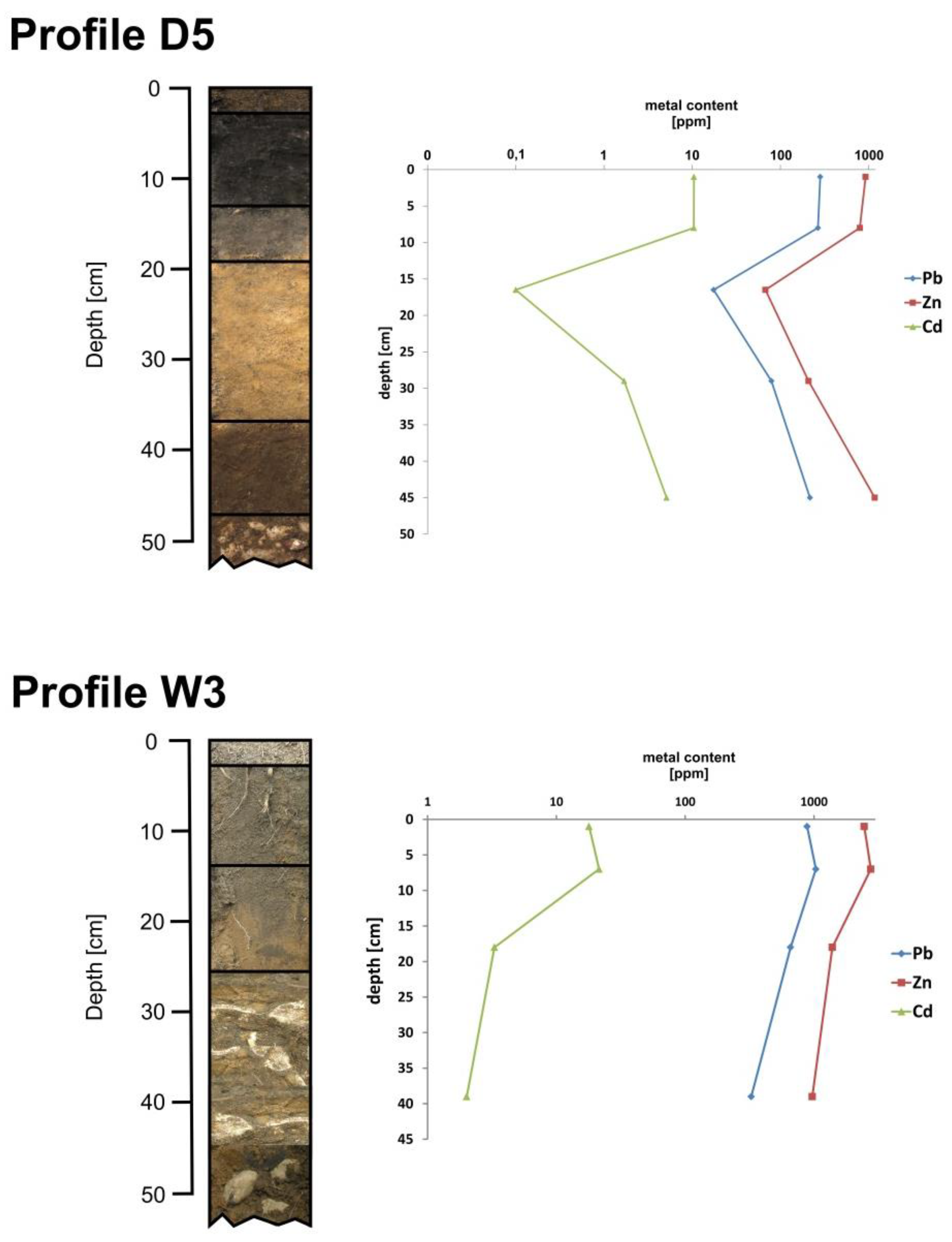
| D5 | 50°15′18.2″ N 19°14′25.6″ E | a | 0–2 | 5.55 | 23.12 | 23.12 | 0.17 | 926 ± 32 | 283 ± 11 | 10.46 ± 0.47 |
| b | 2–14 | 6.06 | 7.16 | 7.16 | 0.07 | 797 ± 18 | 267 ± 2 | 10.45 ± 0.04 | ||
| c | 14–19 | 5.96 | 0.20 | 0.20 | 0.00 | 68 ± 8 | 18 ± 2 | 0.31 ± 0.01 | ||
| W1 | 50°13’36.1” N 19°16’48.3” E | a | 0–2 | 6.74 | 5.76 | 5.76 | 0.06 | 2975 ± 45 | 440 ± 2 | 26.83 ± 0.23 |
| b | 2–18 | 6.97 | 3.40 | 3.40 | 0.04 | 3077 ± 54 | 456 ± 1 | 27.66 ± 0.13 | ||
| W2 | 50°13’36.2” N 19°16’58.1” E | a | 0–2 | 6.93 | 11.57 | 11.08 | 0.10 | 1861 ± 4 | 673 ± 8 | 14.45 ± 0.25 |
| b | 2–17 | 7.36 | 6.24 | 5.07 | 0.05 | 1831 ± 9 | 711 ± 6 | 11.86 ± 0.19 | ||
| W3 | 50°13’28.6” N 19°16’58.7” E | a | 0–2 | 6.34 | 9.22 | 9.22 | 0.07 | 2455 ± 34 | 885 ± 13 | 17.93 ± 0.14 |
| b | 2–12 | 6.67 | 7.47 | 7.47 | 0.07 | 2761 ± 34 | 1035 ± 18 | 21.44 ± 0.34 | ||
| c | 12–24 | 6.69 | 0.68 | 0.68 | 0.01 | 1388 ± 2 | 658 ± 14 | 3.30 ± 0.01 | ||
| W4 | 50°13’27.7” N 19°16’44.5” E | a | 0–2 | 6.74 | 13.89 | 13.84 | 0.12 | 1956 ± 3 | 329 ± 19 | 13.70 ± 1.06 |
| b | 2–20 | 7.08 | 7.11 | 7.10 | 0.07 | 2547 ± 9 | 502 ± 6 | 20.57 ± 0.30 | ||
| c | 20–30 | 7.10 | 2.03 | 2.03 | 0.02 | 2771 ± 27 | 328 ± 3 | 12.59 ± 0.31 | ||
| W5 | 50°13’27.8” N 19°16’35.4” E | a | 0–2 | 7.05 | 3.49 | 3.49 | 0.04 | 1063 ± 9 | 403 ± 2 | 7.42 ± 0.05 |
| b | 2–18 | 7.24 | 3.65 | 3.65 | 0.04 | 1052 ± 6 | 400 ± 14 | 7.32 ± 0.30 | ||
| c | 18–28 | 7.60 | 0.83 | 0.82 | 0.01 | 1124 ± 48 | 207 ± 8 | 4.39 ± 0.21 | ||
| W6 | 50°13’9” N 19°16’11” E | a | 0–3 | 6.21 | 2.04 | 2.04 | 0.02 | 630 ± 15 | 290 ± 4 | 6.28 ± 0.29 |
| b | 3–11 | 6.40 | 1.65 | 1.65 | 0.02 | 583 ± 17 | 275 ± 5 | 4.34 ± 0.01 | ||
| W7 | 50°13’8” N 19°15’56” E | a | 0–3 | 6.99 | 6.33 | 6.11 | 0.07 | 1063 ± 11 | 289 ± 1 | 5.81 ± 0.14 |
| b | 3–19 | 7.00 | 3.79 | 3.70 | 0.05 | 1169 ± 1 | 307 ± 2 | 7.09 ± 0.02 | ||
| c | 19–26 | 7.20 | 1.45 | 1.17 | 0.01 | 639 ± 1 | 118 ± 1 | 2.34 ± 0.01 | ||
| W8 | 50°13’15” N 19°15’56” E | a | 0–4 | 6.47 | 3.44 | 3.44 | 0.04 | 1003 ± 3 | 242 ± 1 | 4.38 ± 0.03 |
| b | 4–20 | 6.50 | 2.78 | 2.78 | 0.03 | 1080 ± 7 | 298 ± 1 | 6.05 ± 0.02 | ||
| W9 | 50°13’15” N 19°16’10” E | a | 0–3 | 6.01 | 1.59 | 1.59 | 0.02 | 480 ± 9 | 146 ± 5 | 3.90 ± 0.04 |
| b | 3–13 | 6.12 | 1.60 | 1.60 | 0.02 | 497 ± 2 | 169 ± 1 | 3.95 ± 0.01 | ||
| W10 | 50°13’25” N 19°15’59” E | a | 0–3 | 6.53 | 2.34 | 2.34 | 0.02 | 652 ± 7 | 207 ± 2 | 3.71 ± 0.01 |
| b | 3–17 | 6.56 | 2.31 | 2.31 | 0.03 | 727 ± 3 | 219 ± 1 | 4.20 ± 0.02 | ||
| Sample Point | Weighted Arithmetic Mean (mg·kg−1 Dry Weight) | Statistical Parameters | ||||||
|---|---|---|---|---|---|---|---|---|
| Zn | Pb | Cd | Zn | Pb | Cd | |||
| D1 | 3320 | 1861 | 32.82 | content | min. | 68 | 18 | 0.31 |
| D2 | 558 | 173 | 7.19 | max. | 3329 | 1877 | 37.58 | |
| D3 | 1251 | 275 | 8.62 | weighted arithmetic mean | 1351 | 550 | 13.01 | |
| D4 | 982 | 244 | 8.69 | median | 937 | 269 | 9.59 | |
| D5 | 619 | 203 | 7.73 | standard deviation | 910 | 535 | 9.83 | |
| coefficient of variation [%] | 77 | 123 | 83.29 | |||||
| W1 | 3066 | 454 | 27.57 | |||||
| W2 | 1159 | 492 | 7.04 | |||||
| W3 | 1032 | 361 | 4.14 | |||||
| W4 | 2582 | 432 | 17.45 | Zn | Pb | Cd | ||
| W5 | 1054 | 340 | 7.34 | content | min. | 480 | 118 | 2.34 |
| W6 | 595 | 279 | 4.87 | max. | 3077 | 1035 | 27.66 | |
| W7 | 1014 | 254 | 5.66 | weighted arithmetic mean | 1549 | 410 | 10.43 | |
| W8 | 1149 | 331 | 4.43 | median | 1102 | 317 | 6.68 | |
| W9 | 287 | 87 | 2.29 | standard deviation | 849 | 232 | 7.53 | |
| W10 | 714 | 217 | 4.11 | coefficient of variation [%] | 1102 | 317 | 6.68 | |
| baseline CB values | ||||||||
| Zn | Pb | Cd | ||||||
| 1 | 552 | 61 | 3.41 | carbonate bedrock for Dlugoszyn area | ||||
| 2 | 86 | 81 | 1.22 | carbonate bedrock for Wilkoszyn area | ||||
| 3 | 104 | 44 | 1.30 | median for topsoil for S Poland [59] | ||||
| 4 | 200 | 84 | 2 | median for topsoil in Cracow-Silesia region [60] | ||||
| 5 | 48 | 15 | 0.15 | median for topsoil in Europe [61] | ||||
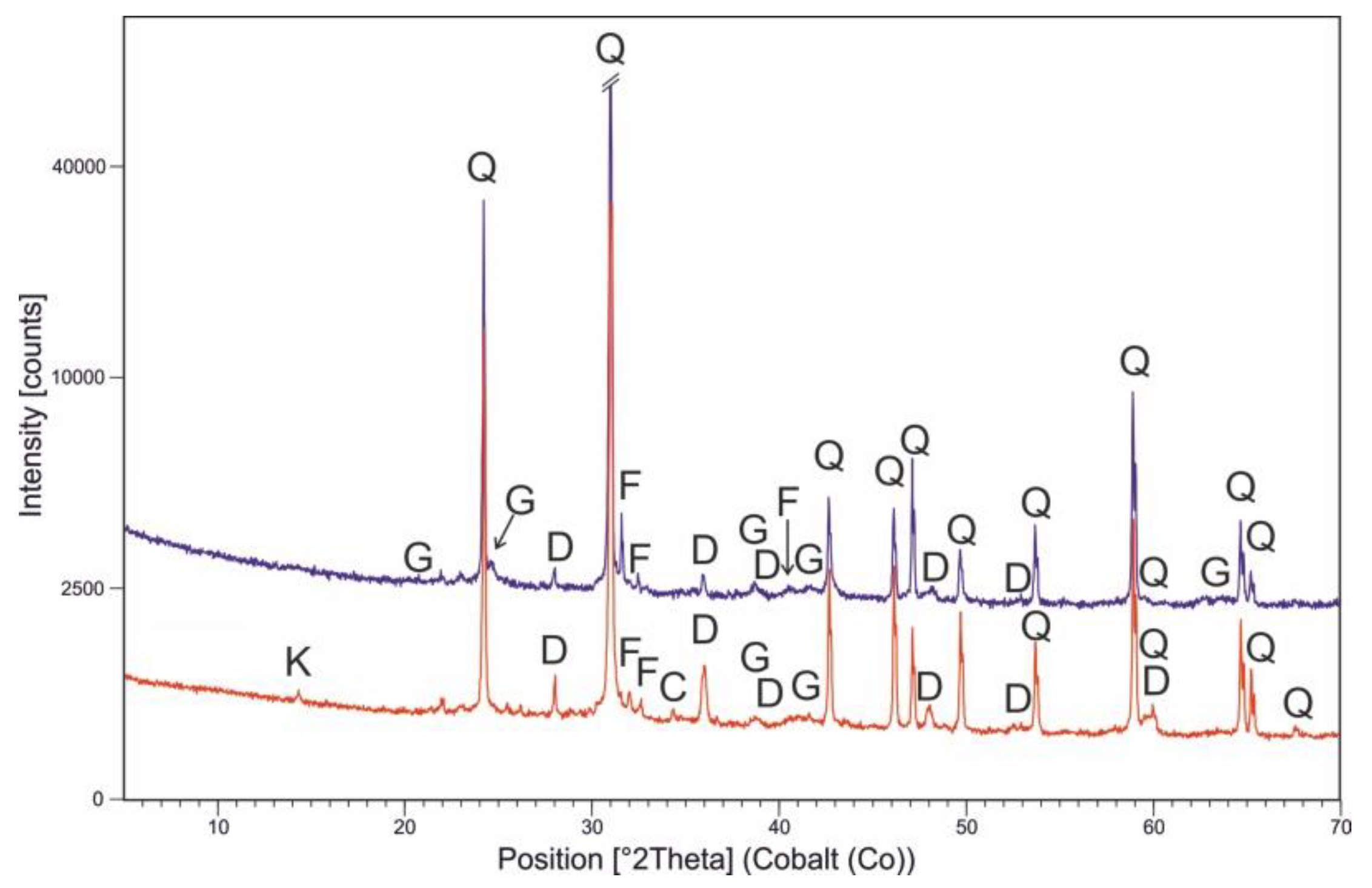
| Mineral Name | D Area | W Area |
|---|---|---|
| [%] | ||
| Quartz | 84.0 | 79.5 |
| Dolomite | 4.5 | 3.0 |
| Goethite | 0.5 | 11.5 |
| Microcline | 3.0 | 2.5 |
| Orthoclase | 3.0 | 1.0 |
| Albite | 2.5 | 2.5 |
| Kaolinite | 2.0 | - |
| Calcite | 0.5 | - |
| Sample Point | Cf | Cdeg | PLI | Igeo | ||||
|---|---|---|---|---|---|---|---|---|
| Zn | Pb | Cd | Zn | Pb | Cd | |||
| D1 | 6.0 | 30.6 | 9.6 | 46.2 | 12.1 | 2.0 | 4.3 | 2.7 |
| D2 | 1.0 | 2.8 | 2.1 | 6.0 | 1.8 | −0.6 | 0.9 | 0.5 |
| D3 | 2.3 | 4.5 | 2.5 | 9.3 | 3.0 | 0.6 | 1.6 | 0.8 |
| D4 | 1.8 | 4.0 | 2.5 | 8.3 | 2.6 | 0.2 | 1.4 | 0.8 |
| D5 | 1.1 | 3.3 | 2.3 | 6.7 | 2.0 | −0.4 | 1.2 | 0.6 |
| W1 | 35.8 | 5.6 | 22.6 | 64.0 | 16.5 | 4.6 | 1.9 | 3.9 |
| W2 | 13.5 | 6.1 | 5.8 | 25.4 | 7.8 | 3.2 | 2.0 | 1.9 |
| W3 | 12.0 | 4.5 | 3.4 | 19.9 | 5.7 | 3.0 | 1.6 | 1.2 |
| W4 | 30.1 | 5.3 | 14.3 | 49.8 | 13.2 | 4.3 | 1.8 | 3.3 |
| W5 | 12.3 | 4.9 | 6.0 | 23.2 | 7.1 | 3.0 | 1.7 | 2.0 |
| W6 | 6.9 | 3.4 | 4.0 | 14.4 | 4.6 | 2.2 | 1.2 | 1.4 |
| W7 | 11.8 | 3.1 | 4.6 | 19.6 | 5.6 | 3.0 | 1.1 | 1.6 |
| W8 | 13.4 | 4.1 | 3.6 | 21.1 | 5.8 | 3.2 | 1.4 | 1.3 |
| W9 | 3.3 | 1.1 | 1.9 | 6.3 | 1.9 | 1.2 | −0.5 | 0.3 |
| W10 | 8.3 | 2.7 | 3.4 | 14.4 | 4.2 | 2.5 | 0.8 | 1.2 |
| Pollution Index | Classes of Soil Quality | Studied Area | |||||
|---|---|---|---|---|---|---|---|
| D | W | ||||||
| Zn | Pb | Cd | Zn | Pb | Cd | ||
| Cf [%] | very high contamination | 0 | 20 | 20 | 90 | 10 | 20 |
| considerable contamination | 20 | 60 | 0 | 10 | 70 | 70 | |
| moderate contamination | 80 | 20 | 80 | 0 | 20 | 10 | |
| low contamination | 0 | 0 | 0 | 0 | 0 | 0 | |
| Cdeg [%] | very high contamination | 20 | 30 | ||||
| considerable contamination | 0 | 60 | |||||
| moderate contamination | 80 | 10 | |||||
| low contamination | 0 | 0 | |||||
| PLI [%] | extremely high pollution | 20 | 70 | ||||
| very high pollution | 0 | 20 | |||||
| high pollution | 20 | 0 | |||||
| moderate to high pollution | 40 | 0 | |||||
| moderate pollution | 20 | 10 | |||||
| unpolluted | 0 | 0 | |||||
| Igeo [%] | Class 6 extremely polluted | 0 | 0 | 0 | 0 | 0 | 0 |
| Class 5 highly to extremely polluted | 0 | 20 | 0 | 20 | 0 | 0 | |
| Class 4 heavy polluted | 0 | 0 | 0 | 50 | 0 | 0 | |
| Class 3 moderately to heavily polluted | 20 | 0 | 20 | 20 | 10 | 30 | |
| Class 2 moderately polluted | 0 | 60 | 0 | 10 | 70 | 60 | |
| Class 1 unpolluted to moderately polluted | 40 | 20 | 80 | 0 | 10 | 10 | |
| Class 0 unpolluted | 40 | 0 | 0 | 0 | 10 | 0 | |
| Sample Point | Cf | Cdeg | PLI | Igeo | ||||
|---|---|---|---|---|---|---|---|---|
| Zn | Pb | Cd | Zn | Pb | Cd | |||
| D1 | 31.9 | 42.3 | 25.2 | 99.5 | 32.4 | 4.4 | 4.8 | 4.1 |
| D2 | 5.4 | 3.9 | 5.5 | 14.8 | 4.9 | 1.8 | 1.4 | 1.9 |
| D3 | 12.0 | 6.3 | 6.6 | 24.9 | 7.9 | 3.0 | 2.1 | 2.1 |
| D4 | 9.4 | 5.6 | 6.7 | 21.7 | 7.1 | 2.7 | 1.9 | 2.2 |
| D5 | 5.9 | 4.6 | 5.9 | 16.5 | 5.5 | 2.0 | 1.6 | 2.0 |
| W1 | 29.5 | 10.3 | 21.2 | 61.0 | 18.6 | 4.3 | 2.8 | 3.8 |
| W2 | 11.1 | 11.2 | 5.4 | 27.7 | 8.8 | 2.9 | 2.9 | 1.9 |
| W3 | 9.9 | 8.2 | 3.2 | 21.3 | 6.4 | 2.7 | 2.5 | 1.1 |
| W4 | 24.8 | 9.8 | 13.4 | 48.1 | 14.8 | 4.0 | 2.7 | 3.2 |
| W5 | 10.1 | 9.1 | 5.6 | 24.9 | 8.0 | 2.8 | 2.6 | 1.9 |
| W6 | 5.7 | 6.3 | 3.7 | 15.8 | 5.1 | 1.9 | 2.1 | 1.3 |
| W7 | 9.7 | 5.8 | 4.4 | 19.9 | 6.3 | 2.7 | 1.9 | 1.5 |
| W8 | 11.0 | 7.5 | 3.4 | 22.0 | 6.6 | 2.9 | 2.3 | 1.2 |
| W9 | 2.8 | 2.0 | 1.8 | 6.5 | 2.1 | 0.9 | 0.4 | 0.2 |
| W10 | 6.9 | 4.9 | 3.2 | 15.0 | 4.7 | 2.2 | 1.7 | 1.1 |
| Sample Point | Cf | Cdeg | PLI | Igeo | ||||
|---|---|---|---|---|---|---|---|---|
| Zn | Pb | Cd | Zn | Pb | Cd | |||
| D1 | 16.6 | 22.1 | 16.4 | 55.2 | 18.2 | 3.5 | 3.9 | 3.5 |
| D2 | 2.8 | 2.1 | 3.6 | 8.4 | 2.7 | 0.9 | 0.5 | 1.3 |
| D3 | 6.3 | 3.3 | 4.3 | 13.8 | 4.5 | 2.1 | 1.1 | 1.5 |
| D4 | 4.9 | 2.9 | 4.3 | 12.2 | 4.0 | 1.7 | 1.0 | 1.5 |
| D5 | 3.1 | 2.4 | 3.9 | 9.4 | 3.1 | 1.0 | 0.7 | 1.4 |
| W1 | 5.4 | 13.8 | 15.3 | 34.5 | 10.5 | 3.4 | 1.9 | 3.2 |
| W2 | 5.9 | 3.5 | 5.8 | 15.2 | 4.9 | 2.0 | 2.0 | 1.2 |
| W3 | 4.3 | 2.1 | 5.2 | 11.5 | 3.6 | 1.8 | 1.5 | 0.5 |
| W4 | 5.1 | 8.7 | 12.9 | 26.8 | 8.3 | 3.1 | 1.8 | 2.5 |
| W5 | 4.8 | 3.7 | 5.3 | 13.7 | 4.5 | 1.8 | 1.7 | 1.3 |
| W6 | 3.0 | 3.3 | 2.4 | 8.7 | 2.9 | 1.0 | 1.1 | 0.7 |
| W7 | 5.1 | 3.0 | 2.8 | 10.9 | 3.5 | 1.8 | 1.0 | 0.9 |
| W8 | 5.7 | 3.9 | 2.2 | 11.9 | 3.7 | 1.9 | 1.4 | 0.6 |
| W9 | 1.4 | 1.0 | 1.1 | 3.6 | 1.2 | −0.1 | −0.5 | −0.4 |
| W10 | 3.6 | 2.6 | 2.1 | 8.2 | 2.7 | 1.3 | 0.8 | 0.5 |
| Sample Point | Cf | Cdeg | PLI | Igeo | ||||
|---|---|---|---|---|---|---|---|---|
| Zn | Pb | Cd | Zn | Pb | Cd | |||
| D1 | 69.2 | 124.0 | 218.8 | 412.0 | 123.4 | 5.5 | 6.4 | 7.2 |
| D2 | 11.6 | 11.5 | 47.9 | 71.1 | 18.6 | 3.0 | 2.9 | 5.0 |
| D3 | 26.1 | 18.4 | 57.4 | 101.9 | 30.2 | 4.1 | 3.6 | 5.3 |
| D4 | 20.5 | 16.3 | 57.9 | 94.7 | 26.8 | 3.8 | 3.4 | 5.3 |
| D5 | 12.9 | 13.5 | 51.5 | 78.0 | 20.8 | 3.1 | 3.2 | 5.1 |
| W1 | 63.9 | 30.3 | 183.8 | 278.0 | 70.9 | 5.4 | 4.3 | 6.9 |
| W2 | 24.2 | 32.8 | 46.9 | 103.9 | 33.4 | 4.0 | 4.5 | 5.0 |
| W3 | 21.5 | 24.1 | 27.6 | 73.2 | 24.3 | 3.8 | 4.0 | 4.2 |
| W4 | 53.8 | 28.8 | 116.4 | 199.0 | 56.5 | 5.2 | 4.3 | 6.3 |
| W5 | 21.9 | 26.7 | 48.9 | 97.5 | 30.6 | 3.9 | 4.2 | 5.0 |
| W6 | 12.4 | 18.6 | 32.5 | 63.5 | 19.6 | 3.0 | 3.6 | 4.4 |
| W7 | 21.1 | 16.9 | 37.8 | 75.8 | 23.8 | 3.8 | 3.5 | 4.7 |
| W8 | 23.9 | 22.0 | 29.6 | 75.5 | 25.0 | 4.0 | 3.9 | 4.3 |
| W9 | 6.0 | 5.8 | 15.3 | 27.0 | 8.1 | 2.0 | 1.9 | 3.3 |
| W10 | 14.9 | 14.5 | 27.4 | 56.7 | 18.1 | 3.3 | 3.3 | 4.2 |
Publisher’s Note: MDPI stays neutral with regard to jurisdictional claims in published maps and institutional affiliations. |
© 2020 by the authors. Licensee MDPI, Basel, Switzerland. This article is an open access article distributed under the terms and conditions of the Creative Commons Attribution (CC BY) license (http://creativecommons.org/licenses/by/4.0/).
Share and Cite
Sutkowska, K.; Teper, L.; Czech, T.; Hulok, T.; Olszak, M.; Zogala, J. Quality of Peri-Urban Soil Developed from Ore-Bearing Carbonates: Heavy Metal Levels and Source Apportionment Assessed Using Pollution Indices. Minerals 2020, 10, 1140. https://doi.org/10.3390/min10121140
Sutkowska K, Teper L, Czech T, Hulok T, Olszak M, Zogala J. Quality of Peri-Urban Soil Developed from Ore-Bearing Carbonates: Heavy Metal Levels and Source Apportionment Assessed Using Pollution Indices. Minerals. 2020; 10(12):1140. https://doi.org/10.3390/min10121140
Chicago/Turabian StyleSutkowska, Katarzyna, Leslaw Teper, Tomasz Czech, Tomasz Hulok, Michał Olszak, and Jan Zogala. 2020. "Quality of Peri-Urban Soil Developed from Ore-Bearing Carbonates: Heavy Metal Levels and Source Apportionment Assessed Using Pollution Indices" Minerals 10, no. 12: 1140. https://doi.org/10.3390/min10121140
APA StyleSutkowska, K., Teper, L., Czech, T., Hulok, T., Olszak, M., & Zogala, J. (2020). Quality of Peri-Urban Soil Developed from Ore-Bearing Carbonates: Heavy Metal Levels and Source Apportionment Assessed Using Pollution Indices. Minerals, 10(12), 1140. https://doi.org/10.3390/min10121140