Article

Geodynamic Emplacement Setting of Late Jurassic Dikes of the Yana–Kolyma Gold Belt, NE Folded Framing of the Siberian Craton: Geochemical, Petrologic, and U–Pb Zircon Data

by
Valery Yu. Fridovsky
1,*,
Kyunney Yu. Yakovleva
1,
Antonina E. Vernikovskaya
1,2,3,
Valery A. Vernikovsky
2,3,
Nikolay Yu. Matushkin
2,3,
Pavel I. Kadilnikov
2,3 and
Nickolay V. Rodionov
1,4
1
Diamond and Precious Metal Geology Institute, Siberian Branch, Russian Academy of Sciences, 677000 Yakutsk, Russia
2
A.A. Trofimuk Institute of Petroleum Geology and Geophysics, Siberian Branch, Russian Academy of Sciences, 630090 Novosibirsk, Russia
3
Department of Geology and Geophysics, Novosibirsk State University, 630090 Novosibirsk, Russia
4
A.P. Karpinsky Russian Geological Research Institute, 199106 St. Petersburg, Russia
*
Author to whom correspondence should be addressed.
Minerals 2020, 10(11), 1000; https://doi.org/10.3390/min10111000
Submission received: 30 September 2020 / Revised: 3 November 2020 / Accepted: 8 November 2020 / Published: 11 November 2020

Abstract

:
We present the results of geostructural, mineralogic–petrographic, geochemical, and U–Pb geochronological investigations of mafic, intermediate, and felsic igneous rocks from dikes in the Yana–Kolyma gold belt of the Verkhoyansk–Kolyma folded area (northeastern Asia). The dikes of the Vyun deposit and the Shumniy occurrence intruding Mesozoic terrigenous rocks of the Kular–Nera and Polousniy–Debin terranes were examined in detail. The dikes had diverse mineralogical and petrographic compositions including trachybasalts, andesites, trachyandesites, dacites, and granodiorites. The rocks showed significant similarities in distributions of REE, and their concentrations of most HFSEs were close to the intermediate ones between ocean islands basalts and enriched middle ocean ridge basalts. We propose that the subduction that was ongoing during the collision of the Kolyma–Omolon superterrane with Siberia led to melting in the asthenospheric wedge and in the lithosphere, which formed a mixed source for the dike systems from both an enriched and a depleted mantle source. The U–Pb SHRIMP-II dates obtained for the dikes corresponded to the Late Jurassic interval of 151–145 Ma. We present a geodynamic model for the northeastern margin of the Siberian Craton for the Tithonian age of the Late Jurassic.

1. Introduction

Identifying the conditions and ages of magmatism in gold-bearing provinces is important for understanding the nature of mineralization systems and the metallogenic evolution of orogenic events [1,2,3,4,5]. The Yana–Kolyma gold belt is the largest in the Verkhoyansk–Kolyma metallogenic province. It is ~1000 km long and ~200 km wide and is situated in the central part of the Verkhoyansk–Kolyma folded area. Past production of gold from the Yana–Kolyma gold belt since the 1930s was approximately 3200 tons, with current estimated resources of about 5000 tons of Au. The belt trends in parallel to the northeastern margin of the Siberian craton [4,6,7]. This is comparable with the scale of major Paleozoic–Mesozoic gold provinces of the World (e.g., Jiaodong, China; Juneau gold belt, Alaska, USA; Lachlan fold belt, Australia; Baikal fold belt, Russia; Southern Tien Shan, Uzbekistan) [8,9].
The Yana–Kolyma gold belt is host to widespread Late Jurassic dike magmatism of the Nera–Bokhapcha complex [10,11,12,13,14,15,16,17]. The compositions of the dikes vary from mafic to felsic; they can reach 15 km in length and can be up to 160 m wide [16]. They occur in groups mainly NE or sometimes NW and WE strike and can also occur near granitoid plutons formed due to the collision between the Kolyma–Omolon superterrane and the Siberian Craton. The dikes cut weakly metamorphosed Mesozoic (T3–J2) terrigenous deposits that compose the continental margin terranes on the northeast of the Siberian craton. For the gold deposits that associate with the dikes, however, the genetic and age connections between the dikes and gold mineralization are not fully understood. For instance, it is not clear in what geodynamic settings the dikes of various compositions formed, what their magmatic sources were, or what is the relationship between the dike and collisional granitoid magmatism and the probable pre-collision island arc magmatism. Published geochronological data for the dikes show a wide range of ages, which prevents reliably correlating their formation with tectonic events in the region. The Rb–Sr isochron ages for the rocks of the dikes indicate the minimal time interval for their emplacement is 17 m.y. from 162 Ma to 145 Ma (Malo–Tarynskoye deposit) [12,13,14,18]. Published U–Pb ages of zircons (SHRIMP-RG method) from felsic dikes of the southeastern fragment of the Yana–Kolyma gold belt set a very brief interval of 153–150 Ma [19]. The dikes are a great tool for reconstructing geodynamic settings and for studying the mantle/crustal input in the generation of magmatic melts in the Late Jurassic on the margin of the Siberian craton. This age interval is important in the development of the northeastern margin of the craton, as it corresponds to the transition from the subduction to collision processes and to the formation of extensive volcanic–plutonic belts and deposits of Au, Sn, and W.
Here, we discuss the results of geostructural, mineralogic–petrographic, geochemical, and U–Pb geochronological investigations of the mafic, intermediate, and felsic rocks from dikes of the Vyun gold deposit and the Shumniy occurrence (hereinafter, the Vyun and Shumniy sites) localized in the Mesozoic terrigenous rocks of the mid-western part of the Verkhoyansk–Kolyma folded area. This combination of a detailed geological characterization of the dikes and petrological and U–Pb zircon geochronology of the rocks enables us to establish their geodynamic emplacement setting and to propose a new tectonic model for the formation of the dikes and related gold deposits of the Yana–Kolyma gold belt.

2. Sample Description, Preparation, and Analytical Methods

2.1. Sample Description and Preparation

The dikes were sampled in trenches and natural outcrops of creeks Vyun and Shumniy (right feeders of Burgandzha River, basin of Elgandzha River). The number, rock types, and coordinates are given in Table 1. Preparation of the samples for analysis was done at the Diamond and Precious Metal Geology Institute, Siberian Branch of the Russian Academy of Sciences (Diamond and Precious Metal Geology Institute (DPMGI) SB RAS, Yakutsk, Russia) and included standard procedures for crushing and grinding.
The handpicked zircons were cast in EpoKwick resin (Buehler Ltd., Lake Bluff, IL, USA) along with reference zircons Temora 2 [20] and 91500 [21] at the Centre of Isotopic Research of A.P. Karpinsky Russian Geological Research Institute (VSEGEI, Saint Petersburg, Russia). The zircons were then half-sectioned and polished. The epoxy disks with the zircons were covered with gold in a cathodic–vacuum atomization unit for one min at a current strength of 20 mA. Transmitted and reflected light images as well as Cathodoluminescence (CL) and Backscattered electrons (BSE) microphotographs reflecting the inner structure and zoning of the zircons were taken to help select analytical spots on the grains surface. The CL and BSE images were obtained on a CamScan MX2500 scanning electron microscope (Electron Optic Services, Inc., Ottawa, Canada); the operating distance was 30.5 mm, accelerating voltage 12 kV, and the current of the practically completely focused beam on the Faraday cylinder 7 nA.

2.2. Analytical Methods

2.2.1. Petrographic Analysis

The petrographic composition of the rocks was studied on a P-211 POLAM polarizing microscope (AO LOMO, St. Petersburg, Russia) (DPMGI SB RAS, Laboratory of Geology and Mineralogy of Noble Metals). The mineralogical composition of the rocks was determined using a MIRA 3 LMU scanning electron microscope (Tescan Orsay, Brno, Czech Republic) at V.S. Sobolev Institute of Geology and Mineralogy SB RAS (Novosibirsk, Russia). Relative standard deviation during analysis of the main components (concentration >10–15 wt.% when recalculated for corresponding oxides) did not exceed 1.5%, and for components with concentrations 1–10 wt.%, no more than 2.0%. Studies of the secondary components with concentrations below 1 wt.% were qualitative.
The major element concentrations in the rocks were determined in the section on physical–chemical analytical methods of the DPMGI SB RAS by combined use of an SF-56 (AO LOMO, St. Petersburg, Russia) spectrometer for SiO2, Al2O3, Fe2O3, P2O5, and TiO2, a METTLER TOLEDO (Greifensee, Switzerland) titrator for MgO and CaO, atomic emission spectrometry on an FPA-0102 photometer for Na2O and K2O, and an atomic absorption spectrometry of an AAS-30 spectrophotometer for MnO. Elements detection limits: spectral photometry was from 0.1%; volume complexometric method was from 0.1%; flame photometry—0.02%; atomic absorption were from 0.0002%; gravimetry was from 0.2%.
The ICP-MS analyses were performed on an Agilent 7500ce (Agilent Technologies, Santa Clara, CA, USA) and an Element2 double-focusing sector field mass analyzer (Thermo Fisher Scientific, Waltham, MA, USA) at the A.P. Vinogradov Institute of Geochemistry SB RAS (Irkutsk, Russia) in accordance with the technique in [22]. The methodology is described in detail by A.E. Vernikovskaya et al. [23].

2.2.2. Zircon U–Pb Dating

The U–Th–Pb isotope analyses of zircons were carried out on the SHRIMP-II SIMS (Australian Scientific Instruments, Canberra, Australia) at the Centre of Isotopic Research of VSEGEI (Saint Petersburg, Russia) using a secondary electron multiplier in the single collector mode following the procedure described in [24]. The current of the primary oxygen ion beam was 4 nA with analytical spots approximately 30 µm in diameter. The collected results were processed with the SQUID-1 software v.1.12 (Berkeley, CA, USA) [25] and the Concordia diagrams were calculated using the ISOPLOT/Ex software v.3.22 (Berkeley, CA, USA) [26]. The U/Pb ratios were normalized to a 206Pb/238U ratio of 0.0668 for interspersed analyses of the TEMORA 2 reference zircon, which corresponded to 416.8 ± 0.3 Ma [20] based on the power law relationship 206Pb/U = a(UO/U)2 [24]. The concentrations of U and Th in the studied zircons were obtained using the 91500-reference zircon with known concentrations of 81.2 U ppm [21]. Common lead was corrected for measured 204Pb/206Pb ratios. For comparison, the 206Pb/238U age corrected for common lead at 207Pb was also calculated for Mesozoic zircons. Individual zircon measurement errors (of ratios and ages) are given on the 1σ level, errors of calculated concordant ages (for total measurements) are given on the 2σ level.

3. Tectonic Setting

3.1. Regional Geology

The Yana–Kolyma gold belt is defined in the central part of the late Mesozoic Verkhoyansk–Kolyma folded area, an accretionary-collisional structure of the northeastern margin of the Siberian Craton (Figure 1). It is localized in the eastern part of the Verkhoyansk fold and thrust belt and mainly within the Kular–Nera and the Polousniy–Debin terranes [4,6,27,28].
The Verkhoyansk fold and thrust belt is composed of Mesoproterozoic–Devonian carbonate-clastic and carbonate rocks and Carboniferous–Middle Jurassic clastic rocks of the passive continental margin of the Siberian Craton. The entire complex was formed by material discharged from the Siberian paleocontinent and has distinct facies changes from west to east with deep-water marine sediments increasingly replacing continental ones [29]. The sedimentary formations of the fold belt include deltaic complexes, submarine fans, proximal shelf deposits, continental slope, and rise deposits [6,30,31]. Igneous rocks in the northern and central parts of the Verkhoyansk fold belt are nearly nonexistent except for individual plutons and dikes of the Kolyma (J3–K1) and Nera–Bokhapcha (J3) complexes.
The Kular–Nera terrane extends for approximately 1100 km from the northwest to the southeast. It borders the Verkhoyansk fold and thrust belt along the large, regional-scale, and transcrustal Adycha–Taryn fault zone [6]. The latter is 40 km wide and over 1500 km long, including the Ten’ka fault to the south and the Baky–Bytantay fault to the north. Many large commercial gold deposits. such as Natalka, Pavlik, Degdekan, and Rodionovskoe, are localized along the Ten’ka fault [4]. The Kular–Nera terrane consists of sequences of upper Permian, Triassic and Lower Jurassic terrigenous sedimentary rocks corresponding to the deep-water part of the Siberian Craton passive continental margin (continental slope and rise). The northwestern part of the Kular–Nera terrane is composed of deformed carbonaceous and argillaceous Triassic–Lower Jurassic turbidites, and the southeastern part consists of upper Permian black shales turbidites [32]. These rocks are metamorphosed to the initial stages of the greenschist facies. The structural pattern is defined by linear folds and faults of northwestern strike manifesting several deformation stages [6,33]. Within the Kular–Nera terrane and in adjacent tectonic structures, the Adycha ore region of the Yana–Kolyma gold belt is defined. It contains a number of gold metallogenic zones (Inyali–Debin, Delakag–Nera, Adycha. etc.) [15,34]. The Vyun deposit and the Shumniy occurrence of the Vyun ore field that are considered in the present paper are located in the Delakag–Nera metallogenic zone.
The Polousniy–Debin terrane is located to the northeast and east of the Kular–Nera terrane. They are separated by the Chakry–Indigirka and Chai–Yureya faults. The Polousniy–Debin terrane is mainly composed of Upper Triassic–Upper Jurassic turbidites. The lower parts of the section are composed of rhythmically alternating argillaceous rocks and sandstones with olistostrome horizons, transitioning up-section into turbidites with a gradual increase of shallow-marine and coarse-grained deposits and a decrease in the rounding degree [35]. In the northern part of the block, the Upper Jurassic rocks have an argillaceous composition with individual andesite, andesibasalt, and basalt flows. In the southern part of the terrane, the alternating siltstone–shale and sandstones also have layers of tuff sandstones and tuff siltstones. In the Debin River basin, a tectonic lens of gabbroids and serpentinites was identified among Jurassic turbidites [36]. There is no consensus among researchers concerning the geodynamic nature of this terrane. Some consider it to be a tuffaceous–terrigenous complex of the back-arc basin (J2–3) of the Uyandina–Yasachnaya island arc [37,38]. Other assign these deposits to turbidites of the continental slope and rise of the Siberian paleocontinent [39]. Some researchers consider this rock association as a fragment of the accretionary wedge formed along the continental margin or the island arc [40,41]. The Polousniy–Debin terrane hosts the largest volume of the Kolyma complex granitoids and volcanic rocks and dikes of the Nera–Bokhapcha complex.
Fragments of the Omulevka terrane are located to the east of the Polousniy–Debin terrane across the Polousniy–Kolyma suture zone represented mostly by thrusts and strike-slips. They also have tectonic contacts with blocks of the Uyandina–Yasachnaya paleo-island arc and ophiolites. The latter marks the axis of the collisional belt of the Chersky Range and construct packs of tectonic sheets [6,40,42]. The fullest ophiolite sections are represented by serpentinized metamorphosed peridotites, ultramafic cumulates, gabbro–amphibolites, and metabasalts. According to Oxman [42], these ophiolites represent relicts of back-arc or marginal sea basins, and their obduction took place ca. 174 Ma.
Fragments of the Late Jurassic Uyandina–Yasachnaya island arc are composed of volcanogenic–sedimentary and volcanic rocks (andesites, basalts, rhyolites, typically large amounts of tuffs of various types and compositions) [49]. The age of this paleo-island arc corresponds to the Bajocian–Kimmeridgian interval (170–157 Ma) according to multiple ammonite and bivalve finds in the volcanogenic–sedimentary and terrigenous rocks [15,16,50]. There are different viewpoints about the subduction direction of the inferred slab [37,51]. Parfenov [6,51] argued for the formation of the Uyandina–Yasachnaya island arc due to the subduction zone dipping under the southwestern margin of the Kolyma–Omolon superterrane. Another group of researchers [16,37,38,45,52] argued that the slab plunged in the opposite direction—beneath the Siberian Craton. In this case, the Uyandina–Yasachnaya arc would occur in the continental margin setting and traces of the Oymyakon Ocean would be located to the northeast of the arc. This explanation agrees well with the location of the gold deposits of the Yana–Kolyma belt in the back-arc region, and they are consistent with the model of formation of orogenic deposits [53,54,55].
In the Omulevka terrane fragments, there are outcrops of upper Precambrian–lower Carboniferous carbonate and terrigenous–carbonate deposits with interbeds of gypsum, anhydrites, red-colored rocks, and conglomerates [42]. The upper Paleozoic rocks are represented by rather deep-water volcanogenic–siliceous–terrigenous rocks and Triassic–Middle Jurassic rocks consisting of siltstones and mudstones with interbeds of limestones, marls, siliceous rocks, andesites, and basalts. On different stratigraphic levels from the Precambrian to the upper Paleozoic, the sections contain volcanics of differentiated tholeiitic and alkaline series of continental rifts. Many researchers consider these fragments of the Omulevka terrane as part of the Kolyma–Omolon superterrane that was part of the Siberian paleocontinent in the early Paleozoic and separated from it in the Late Devonian (Famenian) due to the fact of continental rifting [6,40,56]. Paleomagnetic data support this idea [57]. The greatest discrepancy in latitudes for these terranes with Siberia is recorded for the Permian. In the Late Jurassic, they again drifted towards Siberia and became part of it after accretionary-collisional events.
The magmatic complexes of the studied region are mainly represented by the granitoids of the Main Belt and intermediate-felsic intrusions and volcanics of the Tas–Kystabyt Belt belonging to the Kolyma complex, as well as by mafic–felsic dikes of the Nera–Bokhapcha complex. The Main Belt intrusions are mainly composed of granites and granodiorites formed due to the collision between the frontal structures of the Kolyma–Omolon superterrane and the Verkhoyansk margin of Siberia [6,38,58]. The granites of the Kolyma complex correspond to the S- and I-geochemical types of granites [59]. More recent data indicate that subduction processes were involved in their formation [19]. The U–Pb age of zircons from the granites of the Main Belt is 155–144 Ma [19]. In the southeastern part of the Tas–Kystabyt Belt, dacites of the Taryn subvolcano (149.9 ± 1.2 Ma, U–Pb zircon, [44]) are exposed. The granitoids were preceded by mafic dikes (162 ± 4 Ma, whole rock, Rb–Sr, [12]) and diorites (161.8 Ma, amphibole, 40Ar–39Ar, [59]).
The tectonic structures, magmatism, and ore deposits of the Verkhoyansk–Kolyma folded area are closely related to the Late Jurassic–earliest Early Cretaceous subduction–accretion and collision events at the eastern active continental margin of the Siberian Craton [6]. In the north of the Kular–Nera terrane and in adjacent tectonic structures, the Adycha ore region is identified as part of the Yana–Kolyma gold belt. This region contains, among others, the Inyali-Debin, Adycha and Delakag–Nera metallogenic zones [15,34] with the latter including the Vyun ore field with the Vyun deposit and the Shumniy occurrence.

3.2. Geology of the Vyun Ore Field

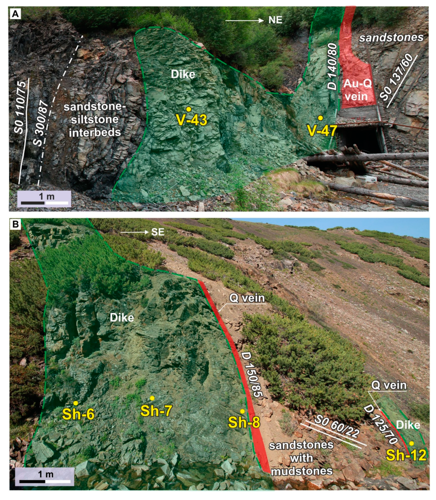
3.2.1. Structures and Host Rocks

The Vyun gold deposit (65°97′33.3″ N, 138°25′06.1″ E) and the Shumniy gold occurrence (66°01′58.7″ N, 138°14′90.4″ E) of the Vyun ore field are located in the upper reaches of the Adycha River (east feeder of the Yana River) (Figure 2). The general tectonic style of the Vyun field is determined by NW-striking imbricated structures and cross-strike NE-trending faults (Figure 2). The main thrust extends to ~400 km with a displacement of several tens of km [6]. In the footwall of the main—Charky–Indigirka—thrust, Upper Triassic deposits of the Kular–Nera terrane crop out, and the hanging wall consists of Middle Jurassic sandstones with siltstone and mudstone interbeds of the Polousniy–Debin terrane. The Charky–Indigirka thrust is manifested as a zone of intense folding and cataclasis of rocks, a tectonic mélange several tens of meters thick. The walls of the thrust are dominated by linear isoclinal and appressed asymmetric folds with a NW strike, SW vergence, and shallow hinges. Overprinting folds are characterized by steeply dipping hinges to the NE, N, and SE. Steep faults of NW strike are manifested as zones of cataclasis and folding several tens of meters wide. Vertical and horizontal displacements change in direction along the strike of the faults. The widely occurring NE-striking faults localize magmatic bodies.

3.2.2. Magmatism and Mineralization

Igneous rocks are widespread, and their age are estimated as Late Jurassic–Early Cretaceous [15,34]. The dikes consist of trachybasalts, andesites, trachyandesites, dacites, and granodiorites. There are also small granodiorite plutons (up to 6 × 3 km) with hornfelsed rims. Individual dikes are traced along strike to several kilometers and have thicknesses up to 30–40 m. Both the dikes and the small plutons have a northeastern strike (Figure 3). They form the Nitkan transverse belt 10–15 km wide and 30–40 km long. The NE strike of the dikes dominates in both walls of the Chakry–Indigirka thrust, and fewer dikes have sublatitudinal and NW strikes. The dikes are boudinaged and bent, which is manifested in different dip azimuths along the strike. Most of them are cut by sinistral strike-slip faults, thrusts, and normal faults. The dikes have many cataclasis manifestations but no clear indications of plastic deformations, which possibly were overprinted by the abundant secondary alterations of the rocks, which include gold–quartz–sulfide mineralization.
The ore bodies are veins, stockworks, and disseminations. On the Vyun deposit, the Shumniy occurrence and others, they are localized in dikes and fault zones (Figure 3). In veins and stockworks, the main minerals are quartz and carbonate with at most 1–3% of sulfides represented mostly by arsenopyrite. Rarer sulfides are pyrite, galena, sphalerite, chalcopyrite, tetrahedrite, freibergite, and argentotetrahedrite. There are insignificant quantities of bournonite and antimony. Gold in veins is free and characterized by high grades of up to several hundreds of g/t Au. The disseminated gold–sulfide mineralization is localized both in the fault zones up to several tens of meters thick and in dikes. The main ore minerals in them are auriferous pyrite and arsenopyrite. The host alteration is sericite–chlorite–quartz in composition. The structural control, ore mineralogy, and wall-rock alterations are typical of orogenic gold deposits [2,3].

4. Results

The studied igneous rocks underwent low temperature alterations due to the hydrothermal–metasomatism and regional metamorphism processes (no higher than the greenschists facies) (Figure 4). The intensity of the alterations increased from a moderate degree in intermediate and felsic rocks to a significant one in the mafic rocks. The phenocrysts did not exceed 10% of the rock volumes. Rock names in the study as a whole and in this section are given in accordance with their petrological and mineralogical characteristics (Table 2, Figure 5).

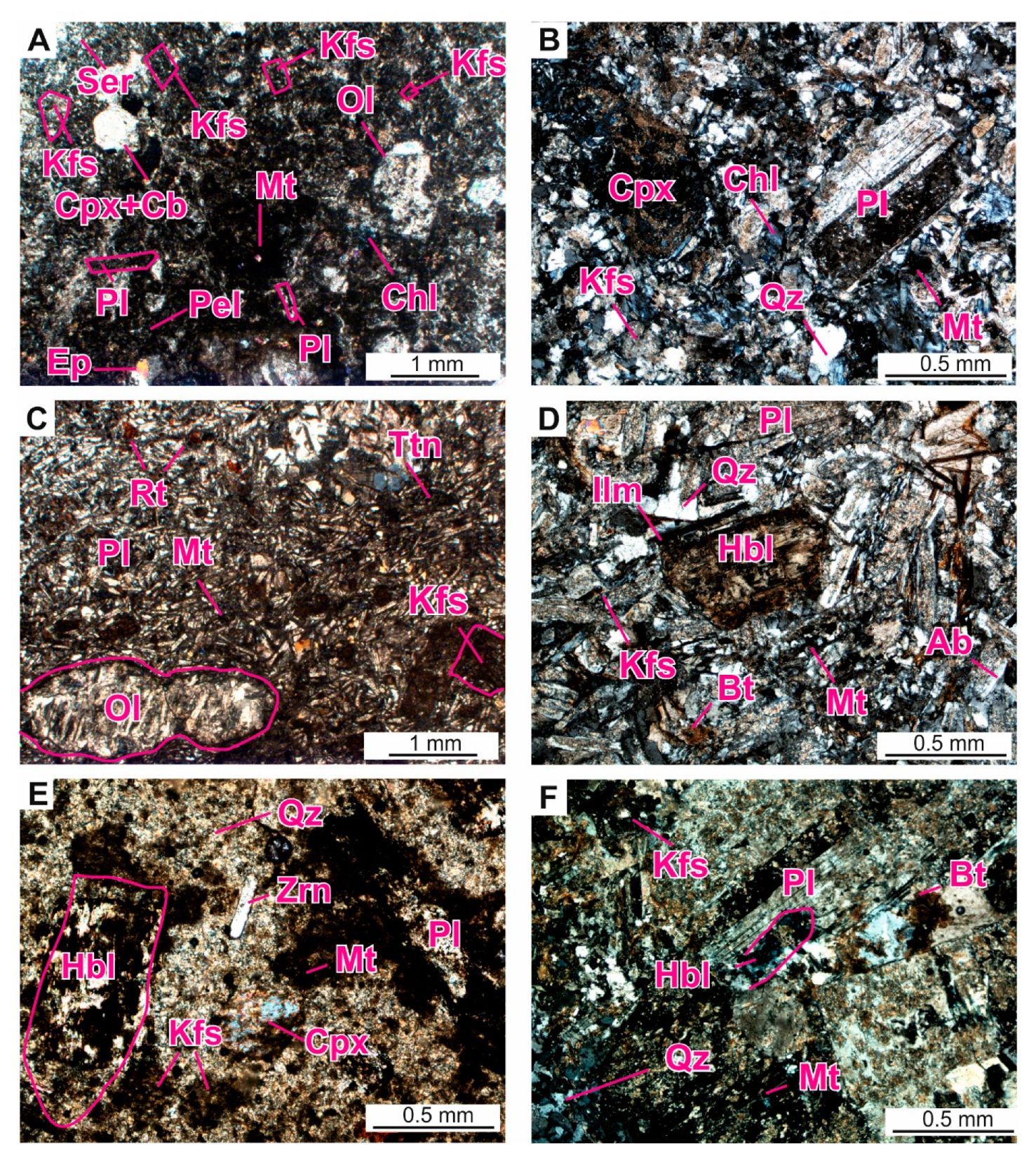
4.1. Petrography and Mineralogy
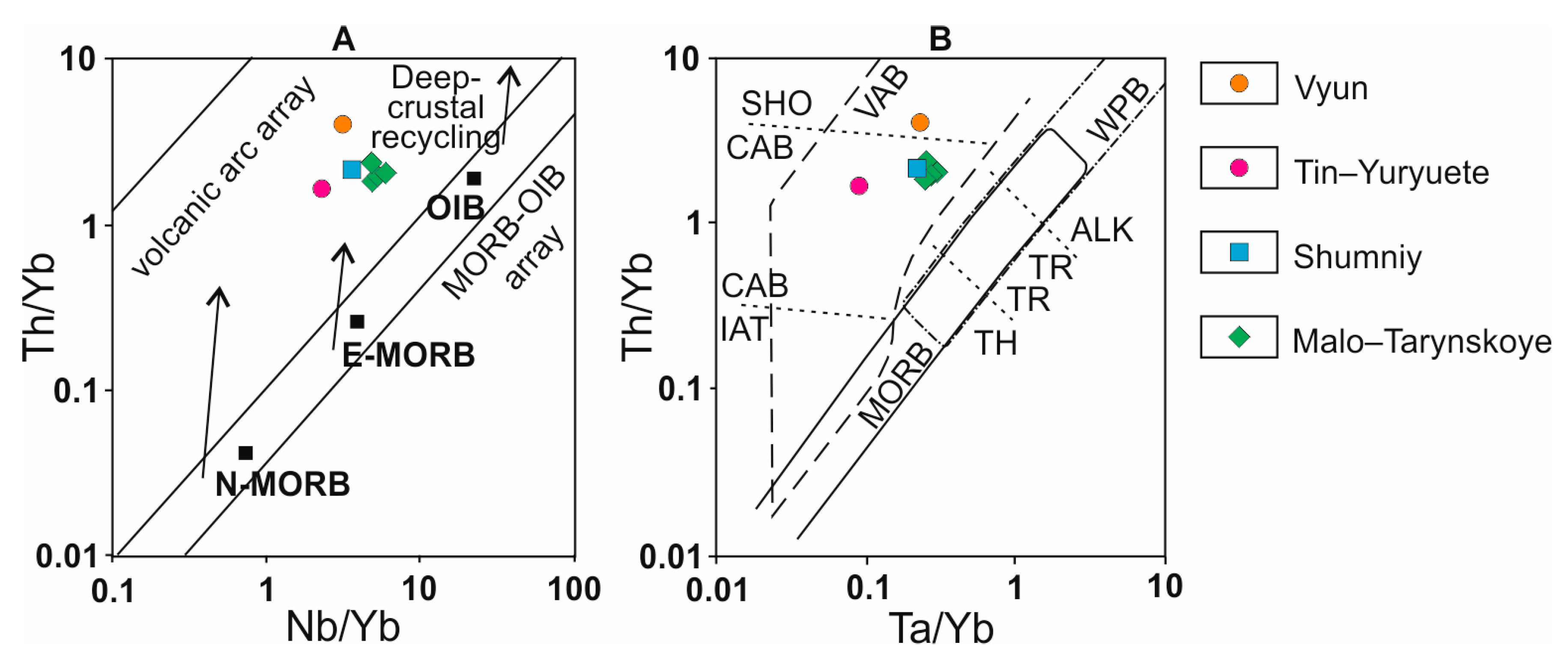
The trachybasalts had a fluidal structure (Figure 4A) and a hyalopilitic and fine-grained porphyritic texture. Olivine phenocrysts (up to 1 mm) were replaced by serpentine, iddingsite, and talc; some had kelyphite rims. Potassium feldspar and plagioclase phenocrysts (up to 0.4 mm) were replaced by albite, and idiomorphic clinopyroxene grains (up to 1 mm) were replaced by carbonate. The groundmass displayed pelitization, sericitization, chloritization, epidotization, and carbonatization. Accessory and opaque minerals included apatite, zircon, ilmenite, pyrite, and magnetite.
The andesites had a fine-grained porphyritic texture (Figure 4B) with plagioclase (up to 1 mm) and clinopyroxene (up to 0.5 mm) phenocrysts (up to 0.5 mm). The fine-grained groundmass had feldspars, clinopyroxenes, and quartz. Secondary minerals and aggregates included chlorite, sericite, albite, epidote, and pelite. Accessory and opaque minerals included apatite, zircon, magnetite, and pyrite.
The trachyandesites had a fine-grained porphyritic, hyalopilitic and intersertal texture (Figure 4C,D). Phenocrysts (up to 1–3 mm) were represented by olivine, potassium feldspar (X Or up to 100), plagioclase (X An up to 37) with potassium feldspar rims, clinopyroxene (CaO = 19.4–20.0 wt.%; FeO = 3.92–9.01 wt.%; MgO = 16.2–18.7 wt.%; Al2O3 = 1.42–2.57 wt.%; small amounts of Cr2O3, MnO, Na2O), and hornblende (SiO2 = 46.7–47.9 wt.%; CaO = 9.55–10.87 wt.%; Na2O = 0.35–0.42 wt.%; K2O = 1.36–1.48 wt.%; Mg# = 0.43–0.61). The groundmass was dominated by plagioclase microlites. Secondary minerals and aggregates included talc, iddingsite, albite, actinolite, chlorite, epidote, carbonates, sericite, and pelite. Accessory and opaque minerals included apatite, zircon, rutile, titanite, magnetite, ilmenite, pyrrhotine, pentlandite, chalcopyrite, and cobaltine.
The dacites (Figure 4E) had a fine-grained and porphyritic texture with hornblende, clinopyroxene, potassium feldspar, and plagioclase phenocrysts (up to 0.5–1 mm). The groundmass was dominated by quartz and feldspars. Secondary minerals and aggregates were chlorite, epidote, sericite, and pelite. Accessory minerals (up to 0.5 mm) were zircon and rutile.
The granodiorite (Figure 4F) had a medium-grained texture and contained mainly plagioclase (up to 4 mm), potassium feldspar, and quartz with lesser quantities of hornblende and biotite. Secondary minerals and aggregates were actinolite, chlorite, sericite, epidote, and pelite. Accessory and opaque minerals were apatite, ilmenite, and pyrite.

4.2. Geochemistry

The results of the chemical analyses of the major and trace elements for mafic, intermediate, and felsic rocks from dikes of the Vyun and Shumniy sites are shown in Table 2 and Table 3. These rocks had highly variable contents of SiO2 (46.8–70.5 wt.%), K2O (0.55–4.06 wt.%), and Na2O (0.78–6.01 wt.%). The loss on ignition (LOI) in these rocks decreased from 9.54–12.74 wt.% in mafic varieties to 4.39–11.85 wt.% and 2.52–5.43 wt.% in intermediate and felsic varieties, respectively. In the SiO2 versus Zr/TiO2 × 0.0001 diagram from [61], these volatile-enriched mafic and intermediate rocks were plotted in the fields for subalkaline and alkaline varieties (Figure 5). However, the lack of alkaline minerals in these rocks allowed us to assign them to trachybasalts and trachyandesites. On the other hand, the less altered felsic rocks, in accordance with their mineralogical–petrographic features and position on this diagram, corresponded to dacites and granodiorites. These results agreed well with major and trace elements concentrations for mafic rocks from the Malo–Tarynskoye site (Table 4 and [12]) and for mafic and felsic rocks from the Tin–Yuryuete site (Table 4 and [18]) (Figure 5). These rocks showed significant similarities in distributions of REE and on spider diagrams (Figure 6). They also showed similarities in distributions of trace elements on spider diagrams with the felsic rocks of the Ergelyakh pluton when compared using data from [13] (Figure 6). Samples from the Vyun and Shumniy sites had moderate (La/Yb)CN ratios (4.30–8.59) and either did not have or had small positive or negative anomalies of Eu/Eu* (0.95–1.11) in which they were similar to rocks from the Malo–Tarynskoye and Tin–Yuryuete sites (La/Yb)CN (5.05–7.55) and Eu/Eu* (0.99–1.1). All rocks showed negative Nb and Ta anomalies, which were the lowest of the rocks of Tin–Yuryuete, and had flat HREE distributions ((Tb/Lu)CN = 0.98–1.39). In these rocks, concentrations of most HFSEs were close to intermediate ones, between ocean islands basalts (OIBs) and enriched middle ocean ridge basalts (E-MORBs), as was the case for the large ion lithophile element Sr, while for such LILEs, such as Rb, K, and Ba, and the HFSE, Th, they were above or close to OIB concentrations (Figure 6).

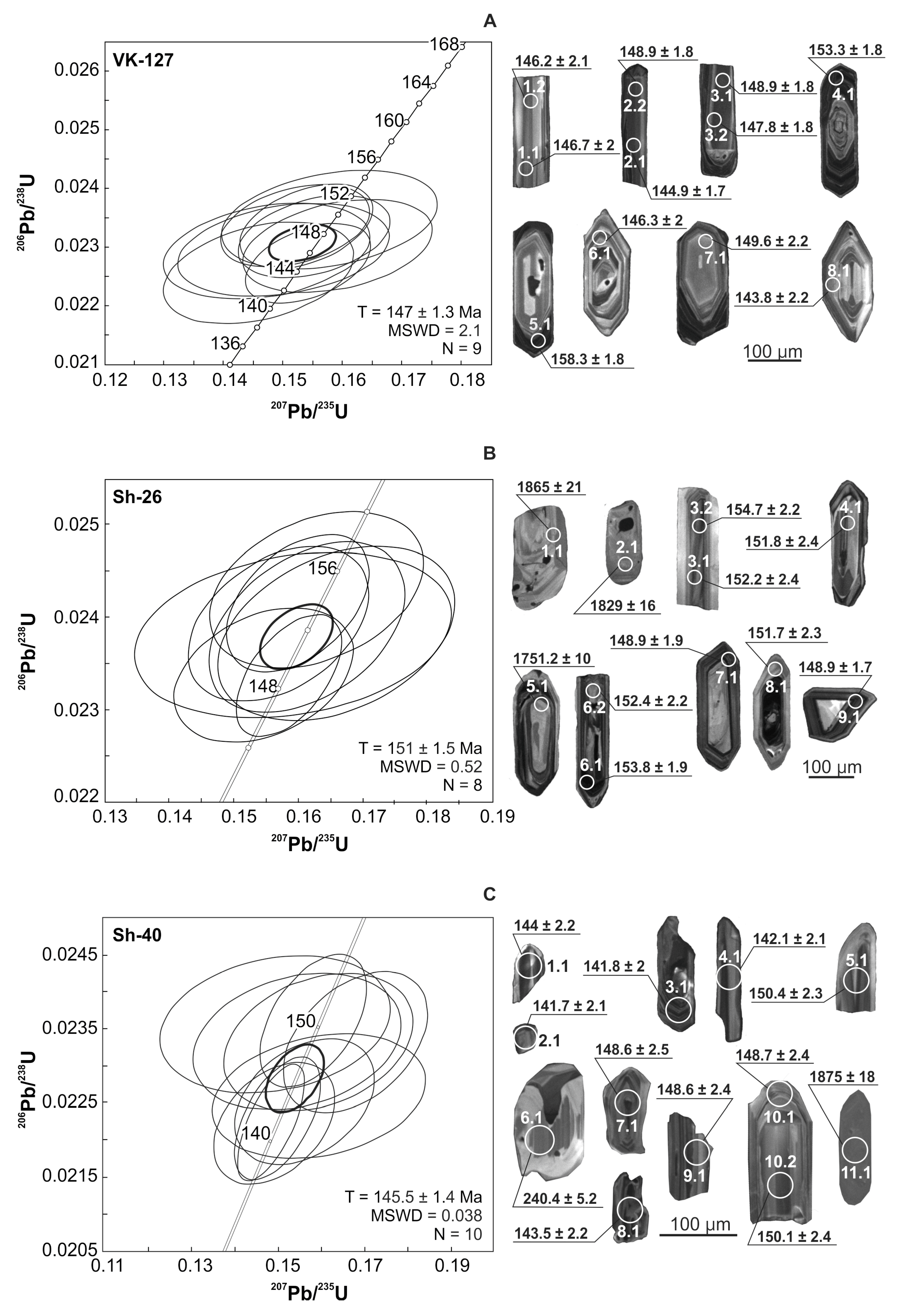
4.3. Zircon Morphology and U–Pb Geochronology

The zircons from the dacite sample VK-127 (n = 8) were 150 to 300 μm long (elongation coefficient Kelong = 1–4), prismatic, brown semitransparent, and idiomorphic (Figure 7A). In the CL images, they exhibited clear magmatic zoning. Measurements at spots 4.1 and 5.1 (dark zones in CL images) yielded higher values of U content relative to the other measurement spots (up to 1105 ppm, 680, on average; Th = 100–737 ppm; Th/U = 0.27–0.72). Their U–Pb ages (153.3 ± 1.8 and 158.3 ± 1.8 Ma, respectively) were apparently overestimated due to the matrix effect [65]. Measurements in the other spots (1.1, 1.2, 2.1, 2.2, 3.1, 3.2, 6.1, 7.1, and 8.1) yielded a Concordia age of 147.0 ± 1.3 Ma (MSWD = 2.1, probability = 0.15) corresponding to the time of crystallization of the dacite (Figure 7A, Table 5). The common lead (206Pbc) fraction was less than 0.3%.
The zircons from the granodiorite sample Sh-26 (n = 9) were brown and reddish, transparent and semitransparent idiomorphic grains of prismatic appearance (Figure 7B), varying in lengths from 150 to 400 μm. Most zircon grains were elongated along the (001) axis relative to the prism, with the elongation coefficient Kelong = 1.5–4. The predominant forms were prisms (110), while bipyramids (311) were less common. One grain (Figure 7B, spot 7.1) had prisms (111) in addition to the mentioned simple forms (110) and (311). In the CL images (Figure 7B), sub-idiomorphic grains demonstrated magmatic zoning and certain signs of a sectorial structure (spots 1.1, 2.1, and 5.1), while idiomorphic crystals and fragments showed magmatic zoning (spots 3.1/3.2, 4.1, 6.1/6.2, 7.1, 8.1, and 9.1). Based on the measurements, the zircons were divided into two age groups. The U content for the first group (spots 3.1/3.2, 4.1, 6.1/6.2, 7.1, 8.1, and 9.1) ranged from 236 to 1860 (634 on average), and the Th content was 51–372 (Th/U = 0.13–0.39; 0.25 on average). The common lead fraction (206Pbc) was less than 0.61% and had not significantly corrected the calculations of the U/Pb systems. The Concordia age was 151.5 ± 1.5 Ma (MSWD = 0.52, probability 0.47), corresponding to the time of rock crystallization (Figure 7B). The second group (spots 1.1, 2.1, and 5.1) was represented by xenocrysts with the following U contents: 246 ppm, 228 ppm, and 597 ppm; and Th contents 105 ppm, 85 ppm, and 112 ppm, respectively. The value of the Th/U ratio ranged between 0.19 and 0.44. These grains yielded discordant ages (207Pb/206Pb) of 1865 ± 21 Ma, 1829 ± 16 Ma, and 1751 ± 10 Ma.
The zircons from the trachyandesite sample Sh-40 (n = 10) were colorless or light-yellow, clear, idiomorphic, and sub-idiomorphic (Figure 7C) 30 to 120 μm long (elongation coefficient Kelong = 1–4). In the CL images, the zircons had a weak or moderate brightness with magmatic oscillatory zoning. The individual crystals (6.1) had mostly sectorial zoning. Measurements allowed defining a cluster (spots 1.1, 2.1, 3.1, 4.1, 5.1, 7.1, 8.1, 9.1, and 10.1/10.2), in which the U contents varied from 329 to 1584 ppm (647 ppm average), Th contents from 105 to 522 ppm, the Th/U ratio was in the range 0.25–0.6 (Table 5). The common lead fraction (206Pbc) was between 0.05% and 1.68%. Excluding spots 6.1 and 11.1 the zircons yielded a Concordia age of 145.5 ± 1.4 Ma (MSWD = 0.038, probability 0.85), which we accepted as the crystallization age for the andesite. One grain (spot 6.1) was clear and prismatic with smoothed out faces. This zircon had low U content (65 ppm), Th = 124 ppm, and a high Th/U ratio of 1.98%. The date obtained for this grain was 240.4 ± 5.2 Ma. Another grain (spot 11.1) was elongated (150 μm) and mainly faced by prism (100). Like the second group zircons from the granite–porphyry sample, this grain was a xenocryst with U and Th contents 265 ppm and 29 ppm, and a Th/U ratio of 1.13. The 207Pb/206Pb age obtained for this zircon w 1875 ± 18 Ma.

5. Discussion and Conclusions

The results of our studies of the dikes of the Vyun deposit and the Shumniy occurrence of the Yana–Kolyma gold belt localized in Mesozoic (T3–J2) terrigenous deposits of the continental margin blocks of the western Verkhoyansk–Kolyma folded area have shown the wide petrographic diversity of the rocks composing them. The compositions include trachybasalts, trachyandesites, dacites, and granodiorites. The dikes on all studied sites and occurrences are dipping at mainly steep angles and associating with various faults. Both the intensely altered mafic and the weakly altered intermediate and felsic rocks of the dikes have close trace elements contents, which are also close to those of Late Jurassic mafic and felsic dikes and small intrusions in the vicinity of the Malo–Tarynskoye and Tin–Yuryuete gold deposits. These trace element concentrations correspond to rocks between the E-MORB and OIB with middle ocean ridge basalt (MORB)-like HREE content (Figure 6). The rocks, including varieties with Kfs phenocrysts, are enriched in LILEs, such as Rb, Ba, K, and in HFSEs such as Th and U. The widest range in concentration among these incompatible elements was observed for K, which is slightly higher for the weakly altered intermediate and felsic rocks (K2O = 0.55–4.04 wt.%), unlike in the strongly altered mafic rocks (K2O = 1.18–4.06 wt.%). This is evidence in favor of a minor mobility of these components during the low temperature rock alteration processes. The rocks were depleted in HFSEs such has Nb, Ta, P, and Ti. The small range of contents of the latter two components in the rocks (P2O5 = 0.09–0.19 wt.%; TiO2 = 0.19–1.06 wt.%) also probably indicates their low mobility. These features also are agreeable with the input of a crustal component in their magmatic source and with fractional crystallization during the evolution of the melts. The mafic varieties were plotted in the fields of calk–alkaline and shoshonitic volcanic arc basalts on the Th/Yb versus Nb/Yb [66] and the Th/Yb versus Ta/Yb [67] tectonic discrimination diagrams (Figure 8). The igneous rocks of the dikes could have formed from a mantle peridotite–pyroxenite source with a 5% input of mantle wedge melting according to the model in [63] (Figure 6) and assimilation of a lower crustal component in a back-arc setting according to [68].
The paleogeodynamic setting for the formation of the Late Jurassic dikes of the Yana–Kolyma gold belt is shown on Figure 9. The Middle–Late Jurassic stage was characterized by the Kolyma–Omolon superterrane and the Verkhoyansk passive margin of the Siberian craton drifting closer to each other. This process was accompanying the subduction of the lithosphere of the small Oimyakon oceanic basin under the Siberian craton and the formation of the Uyandina–Yasachnaya ensialic arc in the Bajocian–Kimmeridgian as was shown previously from paleontological data [15,16,50]. The drift of the Kolyma–Omolon superterrane towards Siberia caused the fragmentation and accretion of the Omulevka terrane, the Uyandina–Yasachnaya island arc, and ophiolites to the margin of the craton. This imbrication of oceanic and continental crust led to the generation of granite melts at the lower–upper crust boundary, and to the formation of the Main belt granitoids in the interval 154–144 Ma (U–Pb data for zircon [19]). This is in good agreement with tectonic models for the studied middle fragment of the Verkhoyansk–Kolyma folded area according to [40,45]. The ongoing subduction led to melting in the asthenospheric wedge and in the lithosphere, which formed a mixed source for the dike systems from both an enriched and a depleted mantle source.
The formation of the mafic, intermediate, and felsic rocks of the dikes of the Nera–Bokhapcha complex took place prior to and synchronously with the collision: from the Oxfordian, at least 162 Ma, according to Rb–Sr geochronology [14] and up to the latest Tithonian, which is confirmed by our new U–Pb SHRIMP-II data for zircons from felsic rocks, 151–145 Ma. Available Ar–Ar dates (for amphibole) [45] and U–Pb SHRIMP-II zircon dates [44] for the intermediate and felsic dikes of the Tas–Kystabyt belt are also in the range of 162–145 Ma; however, assigning the igneous rocks of this belt to the same complex as the Nera–Bokhapcha rocks needs to be further verified.
The volcanic belt was segmented by NE-striking faults of strike-slip and normal fault kinematics that are traced in the southwest in the structures of the Kular–Nera terrane and disappear in the inner zone of the Verkhoyansk margin of Siberia. The NE-striking faults localized the dike suites of the Nera-Bokhapcha complex and the small plutons of the transverse magmatic belts (Nitkan, Burgala, Burkat, etc.). The emplacement of the dikes in NE-striking faults (transverse ramps) is in agreement with the southwestward tectonic transport in the Late Jurassic due to the developing northeastern convergent margin of the Siberian craton. Since the dikes are welding the early fold and thrust structures [69], we can assume this deformation manifested in the latest Late Jurassic (Tithonian) at the youngest. This was preceded by greenschist facies regional metamorphism on the regressive phase in the sedimentary rocks of the Siberian passive continental margin terranes [4]. The observed alignment of deposits and areas of dike magmatism, their association with large regional faults as well as the close ages of dikes and mineralization for some deposits indicate possible common deep sources of mineralization fluids and the Late Jurassic dike magmatism.

Author Contributions

Conceptualization, methodology, writing—original draft preparation, validation, funding acquisition, V.Y.F., K.Y.Y., A.E.V., V.A.V.; investigation, writing—review and editing, V.Y.F., K.Y.Y., A.E.V., V.A.V., N.Y.M., P.I.K., N.V.R.; visualization, K.Y.Y., N.Y.M., P.I.K., N.V.R.; Formal analysis, N.V.R. All authors have read and agreed to the published version of the manuscript.

Funding

This research was supported by the Diamond and Precious Metals Geology Institute, Siberian Branch of the Russian Academy of Sciences and was partially funded by the Russian Foundation for Basic Research (grant no. 18-45-140040 r_a, 18-05-00854, 18-05-70035, and 20-05-00360). This research was financially supported by the Russian Science Foundation (grant no. 19-17-00091).

Acknowledgments

Larisa T. Galechnikova (Section on Physical–Chemical Analytical Methods of DPMGI SB RAS) is thanked for helping with petrochemical studies.

Conflicts of Interest

The authors declare no conflict of interest. The funders had no role in the design of the study; in the collection, analyses, or interpretation of data; in the writing of the manuscript, or in the decision to publish the results.

References

  1. Green, A.H.; Donelly, T.H.; Jahnke, F.M.; Keays, R.R. Evolution of Gold-Bearing Veins in Dykes of the Woods Point Dyke Swarm, Victoria. Miner. Depos. 1982, 17, 175–192. [Google Scholar] [CrossRef]
  2. Groves, D.I.; Goldfarb, R.J.; Gebre-Mariam, M.; Hagemann, S.G.; Robert, F. Orogenic gold deposits: A proposed classification in the context of their crustal distribution and relationship to other gold deposit types. Ore Geol. Rev. 1998, 13, 7–27. [Google Scholar] [CrossRef]
  3. Goldfarb, R.; Groves, D.I.; Gardoll, S. Orogenic gold and geologic time: A global synthesis. Ore Geol. Rev. 2001, 18, 1–75. [Google Scholar] [CrossRef]
  4. Goryachev, N.A.; Pirajno, F. Gold deposit and gold metallogeny of Far East Russia. Ore Geol. Rev. 2014, 59, 123–151. [Google Scholar] [CrossRef]
  5. Kretschmar, U.; McBrid, D. The Metallogeny of Lode Gold Deposits: A Syngenetic Perspective; Elsevier: Amsterdam, The Netherlands, 2015; p. 350. [Google Scholar]
  6. Parfenov, L.M.; Kuzmin, M.I. (Eds.) Tectonics, Geodynamics and Metallogeny of the Territory of the Republic of Sakha (Yakutia); Nauka/Interperiodika: Moscow, Russia, 2001; 571p. (In Russian) [Google Scholar]
  7. Mikhailov, B.K.; Struzhkov, S.D.; Aristov, V.V.; Natalenko, M.V.; Tsymbalyuk, N.V.; Tyamisov, N.E.; Uzunkoyan, A.A. Gold potential of the Yana-Kolyma province. Rudy i Metally (Ores Met.) 2007, 5, 4–17. (In Russian) [Google Scholar]
  8. Goldfarb, R.; Taylor, R.; Collins, G.; Goryachev, N.; Orlandini, O. Phanerozoic continental growth and gold metallogeny of Asia. Gondwana Res. 2014, 25, 48–102. [Google Scholar] [CrossRef]
  9. Kerrich, R.; Goldfarb, R.; Groves, D.; Garwin, S.; Jia, Y. The characteristics, origins, and geodynamic settings of supergiant gold metallogenic provinces. Sci. China Ser. D-Earth Sci. 2000, 43, 1–68. [Google Scholar] [CrossRef]
  10. Indolev, L.N. Dikes of Eastern Yakutia Ore Regions; Nauka: Moscow, Russia, 1979; 189p. (In Russian) [Google Scholar]
  11. Volkov, A.V.; Egorov, V.N.; Prokof’ev, V.Y.; Sidorov, A.A.; Goryachev, N.A.; Biryukov, A.V. Gold deposits in dikes of the Yana-Kolyma belt. Geol. Ore Dep. 2008, 50, 275–298. [Google Scholar] [CrossRef]
  12. Zaitsev, A.I.; Fridovsky, V.Y.; Vernikovskaya, A.E.; Kudrin, M.V.; Yakovleva, K.Y.; Kadilnikov, P.I. Rb-Sr isotope study of the basitic dyke complex of the Taryn ore-magmatic system (northeastern Russia). Otechestvennaya Geol. (Domest. Geol.) 2018, 5, 50–61. (In Russian) [Google Scholar] [CrossRef]
  13. Zaitsev, A.I.; Fridovsky, V.Y.; Kudrin, M.V. Granitoids of the Ergelyakh Intrusion-Related Gold–Bismuth Deposit (Kular-Nera Slate Belt, Northeast Russia): Petrology, Physicochemical Parameters of Formation, and Ore Potential. Minerals 2019, 9, 297. [Google Scholar] [CrossRef] [Green Version]
  14. Zaitcev, A.I.; Fridovsky, V.Y.; Yakovleva, K.Y.; Kudrin, M.V.; Vernikovskaya, A.E. Composition and age of the basitic dikes of the Nastenka site of the Malo–Tarynskoe orogenic gold deposit (Verkhoyansk–Kolyma folded region. Northeast Russia). In Proceedings of the 19th International Multidisciplinary Scientific GeoConference-SGEM, Varna, Bulgaria, 30 June–6 July 2019; Bulgarian Acad. Sci.: Varna, Bulgaria, 2019; Volume 19, pp. 99–108. [Google Scholar] [CrossRef]
  15. Protopopov, R.I.; Trushelev, A.M.; Protopopov, G.K.; Fedorova, S.S.; Sherbakov, O.I.; Kutygin, R.V.; Zharikova, L.P.; Budnikov, I.V.; Smetannikova, L.I.; Yuganova, L.A.; et al. State Geological Map of the Russian Federation. Scale 1:1,000,000 (Third Generation). Series Verkhoyansk-Kolyma, Sheet Q-53—Verkhoyansk. Explanatory Note; VSEGEI Cartographic Factory: Saint Petersburg, Russia, 2016; 415p. (In Russian) [Google Scholar]
  16. Protopopov, R.I.; Trushelev, A.M.; Kuznetsov, Y.V. State Geological Map of the Russian Federation. Scale 1:1,000,000 (Third Generation). Series Verkhoyansk-Kolyma, Sheet Q-54—Ust-Nera. Explanatory Note; VSEGEI Cartographic Factory: Saint Petersburg, Russia, 2019; 845p. (In Russian) [Google Scholar]
  17. Gamyanin, G.N.; Fridovsky, V.Y.; Vikent’eva, O.V. Noble-metal mineralization of the Adycha-Taryn metallogenic zone: Geochemistry of stable isotopes. fluid regime. and ore formation conditions. Rus. Geol. Geophys. 2018, 59, 1271–1287. [Google Scholar] [CrossRef]
  18. Zaitsev, A.I.; Fridovsky, V.Y.; Kudrin, M.V. Rb-Sr classification of magmatic rocks of the western part of the Olchan-Nera metallogenic zone (Eastern Yakutia). Otechestvennaya Geol. (Domest. Geol.) 2016, 6, 43–51. (In Russian) [Google Scholar]
  19. Akinin, V.V.; Prokopiev, A.V.; Toro, J.; Miller, E.L.; Wooden, J.; Goryachev, N.A.; Alshevsky, A.V.; Bakharev, A.G.; Trunilina, V.A. U-Pb SHRIMP ages of granitoides from the main batholith belt (North East Asia). Dokl. Earth Sci. 2009, 426, 605–610. [Google Scholar] [CrossRef]
  20. Black, L.P.; Kamo, S.L.; Allen, C.M.; Davis, D.W.; Aleinikoff, J.N.; Valley, J.W.; Mundil, R.; Campbell, I.H.; Korsch, R.J.; Williams, I.S.; et al. Improved 206Pb/238U microprobe geochronology by the monitoring of a trace-element-related matrix effect; SHRIMP, ID–TIMS, ELA–ICP–MS and oxygen isotope documentation for a series of zircon standards. Chem. Geol. 2004, 205, 115–140. [Google Scholar] [CrossRef]
  21. Wiedenbeck, M.; Allé, P.; Corfu, F.; Griffin, W.L.; Meier, M.; Oberli, F.; von Quadt, A.; Roddick, J.C.; Spiegel, W. Three natural zircon standards for U-Th-Pb, Lu-Hf, trace element and REE analyses. Geostand. Newslet. 1995, 19, 1–23. [Google Scholar] [CrossRef]
  22. Smirnova, E.V.; Flem, B.; Anchutina, E.A.; Mysovskaya, I.N.; Lozhkin, V.I.; Petrov, L.L. Determination of REE, Y, Nb, Zr, Hf, Ta, Th and U in geological reference materials LSHC-1 and Amf-1 by solution and laser ablation ICP-MS. Geostand. Geoanalytic. Res. 2010, 34, 49–65. [Google Scholar] [CrossRef]
  23. Vernikovskaya, A.; Vernikovsky, V.A.; Matushkin, N.; Kadilnikov, P.; Metelkin, D.V.; Romanova, I.; Li, Z.-X.; Bogdanov, E. Early Ediacaran Magmatism in the Yenisei Ridge and Evolution of the Southwestern Margin of the Siberian Craton. Minerals 2020, 10, 565. [Google Scholar] [CrossRef]
  24. Williams, I.S. U–Th–Pb geochronology by ion microprobe. In Reviews in Economic Geology. Applications of Microanalytical Techniques to Understanding Mineralizing Processes; McKibben, M.A., Shanks III, W.C., Ridely, W.I., Eds.; Society of Economic Geologists, Inc.: Socorro, NM, USA, 1998; Volume 7, pp. 1–35. [Google Scholar] [CrossRef] [Green Version]
  25. Ludwig, K.R. SQUID 1.12 A User’s Manual. A Geochronological Toolkit for Microsoft Excel, 1st ed.; Berkeley Geochronology Center Special Publication: Berkeley, CA, USA, 2005; p. 22. Available online: http://bgc.org/isoplot_etc/squid/SQUID2_5Manual.pdf (accessed on 25 June 2020).
  26. Ludwig, K.R. User’s Manual for ISOPLOT/Ex 3.22. A Geochronological Toolkit for Microsoft Excel, 1st ed.; Berkeley Geochronology Center Special Publication: Berkeley, CA, USA, 2005; p. 71. Available online: http://www.bgc.org/isoplot_etc/isoplot/Isoplot3_75-4_15manual.pdf (accessed on 25 June 2020).
  27. Fridovsky, V.Y. Structures of gold ore fields and deposits of Yana-Kolyma ore belt. In Metallogeny of Collisional Geodynamic Settings; Mezhelovsky, N.V., Gusev, G.S., Eds.; GEOS: Moscow, Russia, 2002; Volume 1, pp. 6–241. (In Russian) [Google Scholar]
  28. Prokopiev, A.V.; Borisenko, A.S.; Gamyanin, G.N.; Pavlova, G.G.; Fridovsky, V.Y.; Kondrat’eva, L.A.; Anisimova, G.S.; Trunilina, V.A.; Ivanov, A.I.; Travin, A.V.; et al. Age constraints and tectonic settings of metallogenic and magmatic events in the Verkhoyansk–Kolyma folded area. Rus. Geol. Geophys. 2018, 59, 1237–1253. [Google Scholar] [CrossRef]
  29. Khain, V.E. Tectonics of Continents and Oceans; Nauchnyi Mir: Moscow, Russia, 2001. (In Russian) [Google Scholar]
  30. Prokopiev, A.V.; Ershova, V.B.; Miller, E.L.; Khudoley, A.K. Early Carboniferous paleogeography of the northern Verkhoyansk passive margin as derived from U–Pb dating of detrital zircons: Role of erosion products of the Central Asian and Taimyr–Severnaya Zemlya fold belts. Rus. Geol. Geophys. 2013, 54, 1195–1204. [Google Scholar] [CrossRef]
  31. Malyshev, S.V.; Khudoley, A.K.; Prokopiev, A.V.; Ershova, V.B.; Kazakova, G.G.; Terentyeva, L.B. Source rocks of Carboniferous-Lower Cretaceous terrigenous sediments of the northeastern Siberian Platform: Results of Sm-Nd isotope-geochemical studies. Rus. Geol. Geophys. 2016, 57, 421–433. [Google Scholar] [CrossRef]
  32. Konstantinovsky, A.A. Structure and geodynamics of the Verkhoyansk Fold-Thrust Belt. Geotectonics 2007, 41, 337–354. [Google Scholar] [CrossRef]
  33. Fridovsky, V.Y. Structural control of orogenic gold deposits of the Verkhoyansk–Kolyma folded region, northeast Russia. Ore Geol. Rev. 2018, 103, 38–55. [Google Scholar] [CrossRef]
  34. Vdovina, L.G.; Skuba, V.D.; Musalitin, L.A. State Geological Map of Russia, Scale 1:200,000 (Second Edition). Series Verkhoyansk, Sheet Q-54-XIX, XX (Upper Adycha R.). Explanatory Note; Yangeologiya: Bagatay, Russia, 2005. (In Russian) [Google Scholar]
  35. Gusev, G.S. Folded Structures and Faults of the Verkhoyansk–Kolyma System of Mesozoides; NAUKA: Moscow, Russia, 1979; 207p. (In Russian) [Google Scholar]
  36. Khanchuk, A.I.; Ivanov, V.V. Geodynamics of the East of Russia in the Meso-Cenozoic and Gold Mineralization; FEGI FEB RAS: Vladivostok, Russia, 1999. (In Russian) [Google Scholar]
  37. Ged’ko, M.I. The Late Jurassic Uyandina-Yasachnaya island arc. Geotektonika (Geotectonics) 1998, 2, 88–100. (In Russian) [Google Scholar]
  38. Zonenshain, L.P.; Kuzmin, M.I.; Natapov, L.M. Tectonics of lithospheric plates on the territory of the USSR. Volume 2; Nedra: Moscow, Russia, 1990; 334p. (In Russian) [Google Scholar]
  39. Tilman, S.M.; Bogdanov, N.A. Tectonic Map of the Northeast Asia; Kartografiya: Moscow, Russia, 1992.
  40. Sokolov, S.D. Tectonics of Northeast Asia: An overview. Geotectonics 2010, 44, 493–509. [Google Scholar] [CrossRef]
  41. Parfenov, L.M.; Khanchuk, A.I.; Badarch, G.; Miller, R.J.; Naumova, V.V.; Nokleberg, W.J.; Ogasawara, M.; Prokopiev, V.; Yan, H. Geodynamics Map of Northeast Asia: U.S. Geological Survey Scientific Investigations Map 3024, 2 Sheets, Sheet 1, Scale 1:5,000,000; USGS: Denver, CO, USA, 2013. Available online: http://pubs.usgs.gov/sim/3024 (accessed on 26 June 2020).
  42. Oxman, V.S. Tectonics of the Chersky Collisional Belt (Northeastern Asia); GEOS: Moscow, Russia, 2000; 268p. (In Russian) [Google Scholar]
  43. Metelkin, D.V.; Vernikovsky, V.A.; Tolmacheva, T.Y.; Matushkin, N.Y.; Zhdanova, A.I.; Pisarevsky, S.A. First paleomagnetic data for the New Siberian Islands: Implications for Arctic paleogeography. Gond. Res. 2016, 37, 308–323. [Google Scholar] [CrossRef]
  44. Prokopiev, A.V.; Bakharev, A.G.; Toro, J.; Miller, E.L. The Tas-Kystabyt magmatic belt (northeastern Asia): First U-Pb (SHRIMP) and Sm-Nd data. In Granites and Earth Evolution: Geodynamic Position, Petrogenesis and Ore Potential of Granitoid Batholiths; BSC SB RAS: Ulan Ude, Russia, 2008; pp. 305–308. (In Russian) [Google Scholar]
  45. Layer, P.W.; Newberry, R.; Fujita, K.; Parfenov, L.; Trunilina, V.; Bakharev, A. Tectonic setting of the plutonic belts of Yakutia, northeast Russia, based on 40Ar/39Ar geochronology and trace element geochemistry. Geology 2001, 29, 167–170. [Google Scholar] [CrossRef]
  46. Zaitsev, A.I.; Fridovsky, V.Y.; Kudrin, M.V. Intensive options of granitoid formation in Kurdat and Samyr massives, Tas-Kystabyt magmatic belt. Otechestvennaya Geol. (Domest. Geol.) 2017, 5, 80–89. (In Russian) [Google Scholar]
  47. Kotlyar, I.N.; Zhulanova, I.L.; Rusakova, T.B.; Gagieva, A.M. Discrimination scheme for Mesozoic magmatic complexes of the Kolyma-Okhotsk region and some particularities of their evolution. In Proceedings of Conference ‘Magmatism and Metamorphism of Northeastern Asia’, Magadan, Russia, 4–6 April 2000; NEISRI FEB RAS: Magadan, Russia, 2000; pp. 48–52. (In Russian) [Google Scholar]
  48. Izokh, A.E.; Goryachev, N.A.; Al’shevskii, A.V.; Akinin, V.V. Sokhatiny Differentiated Gabbro-Monzodiorite Intrusion from the Example of Sin-Batholitic Gabbroids of Yano-Kolymskaya System. Dokl. Earth Sci. 2012, 444, 549–552. [Google Scholar] [CrossRef]
  49. Trunilina, V.A.; Roev, S.P.; Orlov, Y.S.; Oxman, V.S. Magmatism of Different Geodynamic Settings (Junction Zone of the Verkhoyansk Margin of the Siberian Continent and the Kolyma-Omolon Microcontinent); YaSC SB RAS: Yakutsk, Russia, 1999; 168p. (In Russian) [Google Scholar]
  50. Paraketsov, K.V.; Paraketsova, G.I. Stratigraphy and Fauna of the Late Jurassic and Early Cretaceous Deposits of the North-East of the USSR; Nedra: Moscow, Russia, 1989; 289p. (In Russian) [Google Scholar]
  51. Parfenov, L.M. Continental Margins and Island Arcs of Mesozoic Formations of Northeastern Asia; Nauka: Novosibirsk, Russia, 1984; 192p. (In Russian) [Google Scholar]
  52. Stavsky, A.P.; Ged’ko, M.I.; Danilov, V.G. Uyandino-Yasachnaya volcanic island arc. In Geological Mapping of Volcanic-Plutonic Belts; Nedra: Moscow, Russia, 1994; pp. 265–297. (In Russian) [Google Scholar]
  53. Goldfarb, R.J.; Groves, D.I. Orogenic gold: Common or evolving fluid and metal sources through time. Lithos 2015, 233, 2–26. [Google Scholar] [CrossRef]
  54. Groves, D.I.; Santosh, M.; Deng, J.; Wang, Q.; Yang, L.; Zhang, L. A holistic model for the origin of orogenic gold deposits and its implications for exploration. Miner. Depos. 2019, 55, 275–292. [Google Scholar] [CrossRef]
  55. Groves, D.I.; Zhang, L.; Santosh, M. Subduction. mantle metasomatism, and gold: A dynamic and genetic conjunction. GSA Bull. 2019. [Google Scholar] [CrossRef]
  56. Parfenov, L.M.; Natapov, L.M.; Sokolov, S.D.; Tsukanov, N.V. Terranes and accretionary tectonics of Northeastern Asia. Geotektonika (Geotectonics) 1993, 1, 68–78. (In Russian) [Google Scholar]
  57. Stone, D.B.; Minyuk, P.; Kolosev, E. New paleomagnetic paleolatitudes for the Omulevka terrane of northeast Russia: A comparison with the Omolon terrane and the eastern Siberian platform. Tectonophysics 2003, 377, 55–82. [Google Scholar] [CrossRef]
  58. Natapov, L.M.; Stavstky, L.P. Geodynamic model of the northeast of the USSR and its use for metallogenic analysis. Sov. Geol. (Sov. Geol.) 1985, 3, 70–78. (In Russian) [Google Scholar]
  59. Bakharev, A.G.; Zaitsev, A.I. The Tas–Kystabyt magmatic belt. In Tectonics, Geodynamics and Metallogeny of the Rupublic of Sakha (Yakutia); Parfenov, L.M., Kuzmin, M.I., Eds.; MAIK Nauka/Interperiodika: Moscow, Russia, 2001; pp. 263–269. (In Russian) [Google Scholar]
  60. Whitney, D.L.; Evans, B.P. Abbreviations for names of rock-forming minerals. Am. Mineral. 2010, 95, 185–187. [Google Scholar] [CrossRef]
  61. Winchester, J.A.; Floyd, P.A. Geochemical discrimination of different magma series and their differentiation products using immobile elements. Chem. Geol. 1977, 20, 325–343. [Google Scholar] [CrossRef] [Green Version]
  62. McDonough, W.F.; Sun, S.-S. The composition of the Earth. Chem. Geol. 1995, 120, 223–254. [Google Scholar] [CrossRef]
  63. White, W.; Copeland, P.; Gravatt, D.R.; Devine, J.D. Geochemistry and geochronology of Grenada and Union islands, Lesser Antilles: The case for mixing between two magma series generated from distinct sources. Geosphere 2017, 13, 1359–1391. [Google Scholar] [CrossRef] [Green Version]
  64. Sun, S.-S.; McDonough, W.F. Chemical and isotopic systematics of oceanic basalts: Implications for mantle composition and processes. Geol. Soc. Lond. Spec. Publ. 1989, 42, 313–345. [Google Scholar] [CrossRef]
  65. Williams, I.S.; Hergt, J.M. U-Pb dating of Tasmanian dole rites; a cautionary tale of SHRIMP analysis of high-U zircon. In Beyond 2000, New Frontiers in Isotope Geoscience (Incorporating ACOG 4): Abstracts and Proceedings, Lorne, Australia, 30 January–4 February 2000; Woodhead, J.D., Hergt, J.M., Noble, W.P., Eds.; University of Melbourne: Melbourne, Australia, 2000; pp. 185–188. [Google Scholar]
  66. Pearce, J.A. Geochemical fingerprinting of oceanic basalts with applications to ophiolite classification and the search for Archean oceanic crust. Lithos 2008, 100, 14–48. [Google Scholar] [CrossRef]
  67. Pearce, J.A. Trace element characteristics of lavas from destructive plate boundaries. In Andesites: Orogenic Andesites and Related Rocks; Wyman, D.A., Ed.; John Wiley & Sons, Ltd.: Chichester, UK, 1982; pp. 525–548. Available online: http://orca.cf.ac.uk/id/eprint/8625 (accessed on 10 November 2020).
  68. Kelemen, P.B.; Hanghøj, K.; Greene, A.R. 3.18—One View of the Geochemistry of Subduction-Related Magmatic Arcs, with an Emphasis on Primitive Andesite and Lower Crust. Treatise Geochem. 2007, 3, 1–70. [Google Scholar] [CrossRef]
  69. Fridovsky, V.Y.; Yakovleva, K.Y.; Vernikovskaya, A.E.; Vernikovsky, V.A.; Rodionov, N.V.; Lokhov, K.I. Late Jurassic (151–147 Ma) Dike Magmatism of the Northeastern Margin of the Siberian Craton. Dokl. Earth Sci. 2020, 491, 117–120. [Google Scholar] [CrossRef]
Figure 1. Geology of the central part of the Verkhoyansk–Kolyma folded area with the main tectonic units, Jurassic–Cretaceous magmatism, and sites of investigations. Compiled using [6,39,43]. Colored numbers show ages in Ma: red—U–Pb SHRIMP-II method, magenta—U–Pb SHRIMP-RG method; blue—Ar–Ar method; black—Rb–Sr method (numbers in brackets come from the literature: (1)—[44]; (2)—[45]; (3)—[13]; (4)—[12]; (5)—[46]; (6)—[18]; (7)—[6]; (8)—[14]; (9)—[47]; (10)—[19]; (11)—[48]). Inset: VFTB––Verkhoyansk fold and thrust belt; OT—Okhotsk terrane; investigation sites are marked as numbers in yellow circles: 1—Malo–Tarynskoye site; 2—Tin–Yuryuete site; 3—Vyun deposit and Shumniy occurrence; sutures: P—Polousniy-Kolyma; S—South Anyui; thrusts: A—Adycha-Taryn; C—Chakry–Indigirka.
Minerals 10 01000 g001
Figure 2. Geology of the region of the Vyun and Shumniy creeks, sampling sites locations and new U–Pb ages. The approximate location of the area is shown on Figure 1.
Minerals 10 01000 g002
Figure 3. Photographs of dated dikes and locations of samples: (A) Vyun deposit, (B) Shumniy ore occurrence. Attitude: S0—bedding, S—fault, D—dike.
Minerals 10 01000 g003
Figure 4. Thin section photographs of rocks from dikes (crossed nicols): (A) sample V3-9, trachybasalt; (B) sample Sh-215, andesite; (C) sample Sh-25, trachyandesite; (D) sample Sh-39, trachyandesite; (E) sample VK-127, dacite; (F) sample Sh-26, granodiorite. Abbreviations of minerals names from [60]: Ab—albite, Bt—biotite, Cb—carbonate, Chl—chlorite, Cpx—clinopyroxene, Ep—epidote, Hbl—hornblende, Ilm—ilmenite, Kfs—potassium feldspar, Mt—magnetite, Ol—olivine, Pel—pelitization, Pl—plagioclase, Qz—quartz, Rt—rutile, Ser—sericite, Ttn—titanite, and Zrn—zircon.
Minerals 10 01000 g004
Figure 5. SiO2 versus Zr/TiO2 × 0.0001 diagram from [61] for the studied igneous rocks. Samples from the Tin–Yuryuete site included samples from [18]. Samples from the Malo–Tarynskoye deposit included samples from [12].
Minerals 10 01000 g005
Figure 6. REE diagram (A) and spider diagram (B) for the studied igneous rocks. Chondrite and primitive mantle normalizing values were from [62]. Blue and grey fields—concentrations for Grenada Island (Lesser Antilles island arc) basalts with, respectively, a peridotite–pyroxenite source (5% mantle wedge melting) and a mainly peridotite source (25% Mg-enriched mantle wedge melting) [63]. Concentrations from the Ergelyakh pluton granite–porphyry and granodiorite–porphyry were from [13].
Minerals 10 01000 g006
Figure 7. Concordia diagrams and cathodoluminescence (CL) images of zircons from dacite sample VK-127 (A); granodiorite sample Sh-26 (B); and trachyandesite sample Sh-40 (C) from the Vyun and Shumniy sites. Numbered circles on the grains denote analytical spots and correspond to the numbers in Table 5.
Minerals 10 01000 g007
Figure 8. Tectonic setting discrimination diagrams for the mafic igneous rocks: (A) Th/Yb versus Nb/Yb from [66]; (B) Th/Yb versus Ta/Yb from [67]. All data points on this diagram are from this study. Abbreviations are types of mafic volcanic rocks: MORBs—middle ocean ridge basalts; N-MORBs—normal middle ocean ridge basalts; E-MORBs—enriched middle ocean ridge basalts; OIBs—ocean islands basalts; WPBs—within plates basalts; ALK—alkalic; TH—oceanic tholeiitic; VABs—volcanic arc basalts; IAT—island arc tholeiitic; CABs—calk-alkaline basalts; SHO—shoshonitic; TRs—transitions between ALK and TH.
Minerals 10 01000 g008
Figure 9. Model section through the northeastern margin of Siberia for the latest Jurassic (Tithonian). A—Adycha–Taryn thrust; C—Chakry–Indigirka thrust; P—Polousniy–Kolyma suture.
Minerals 10 01000 g009
Table 1. List of the studied samples from the Vyun and Shumniy sites with GPS coordinates.
Number
Order
Sample No.Rock TypeCoordinates
NE
1V3-8Trachyandesite65.9640138.2590
2V3-9Trachybasalt65.9640138.2589
3V3-10Dacite65.9640138.2589
4VJ-108Trachyandesite65.9695138.2795
5V-20Trachyandesite65.9728138.2481
6V-21Trachyandesite65.9728138.2481
7V-22Trachyandesite65.9728138.2481
8V-43Trachyandesite65.9735138.2513
9V-47Trachyandesite65.9733138.2506
10VF-39Trachyandesite65.9733138.2298
11VK-8Trachybasalt65.9865138.2801
12VK-107Dacite65.9483138.2969
13VK-108Dacite65.9483138.2969
14VK-125Trachyandesite65.9760138.2603
15VK-127Dacite65.9759138.2605
16VK-128Trachyandesite65.9759138.2605
17Sh-6Trachyandesite66.0159138.1491
18Sh-7Andesite66.0159138.1491
19Sh-8Andesite66.0159138.1491
20Sh-12Trachybasalt66.0159138.1491
21Sh-25Trachyandesite66.0143138.1393
22Sh-26Granodiorite66.0143138.1393
23Sh-28Trachybasalt66.0143138.1393
24Sh-30Andesite66.0143138.1393
25Sh-38Trachybasalt66.0142138.1412
26Sh-39Trachyandesite66.0142138.1412
27Sh-40Trachyandesite66.0142138.1412
28Sh-41Andesite66.0142138.1412
29Sh-95Trachyandesite66.0215138.1954
30Sh-159Trachybasalt66.0123138.1774
31Sh-160Trachyandesite66.0123138.1774
32Sh-215Andesite66.0185138.1636
33Sh-217Andesite66.0185138.1636
34Sh-218Andesite66.0185138.1636
35K-4Andesite66.0166138.1996
36K-5Andesite66.0160138.2006
37K-8Trachyandesite66.0138138.2059
38K-9Trachyandesite66.0208138.1797
39K-11Andesite66.0207138.1798
40K-13Andesite66.0207138.1798
41K-14Trachyandesite66.0205138.1801
42K-15Trachyandesite66.0204138.1802
Table 2. Major element compositions of studied igneous rocks from the Vyun and Shumniy sites.
Sample NumberVK-8V3-9V3-8VJ-108V-20V-47V-21VK-128V-22V-43VK-
125
VF-39VK-
127
V3-10VK-
108
VK-
107
Sh-12Sh-38Sh-159Sh-28Sh-40
Number Order123456789101112131415161718192021
Rock TypeTBTBTATATATATATATATATATADDDDTBTBTBTBTA
Components, wt.%SiO246.851.454.254.855.356.356.456.557.158.861.562.464.166.167.670.549.451.551.852.254.2
TiO21.060.460.470.540.650.530.530.580.570.520.390.370.350.40.30.190.630.570.540.570.6
Al2O314.716.416.516.816.516.415.815.71716.915.615.316.915.315.314.817.515.614.215.216
Fe2O30.941.412.721.290.280.591.980.631.450.870.720.812.31.121.20.351.61.050.963.870.59
FeO6.223.222.123.154.114.112.583.763.623.4432.581.272.512.411.935.325.374.292.235.88
MnO0.140.080.080.10.110.10.110.170.120.130.070.060.070.050.080.070.130.130.10.040.11
MgO6.732.851.943.212.982.82.472.42.412.451.111.240.321.50.420.065.144.874.982.723.72
CaO7.726.816.365.225.424.976.35.295.135.043.383.82.713.082.372.424.216.266.315.233.86
Na2O1.420.781.230.90.992.043.551.140.182.982.923.263.850.966.893.794.731.811.232.722.35
K2O1.664.064.042.113.272.732.043.413.410.832.982.933.021.730.73.471.182.092.612.412.14
P2O50.170.090.110.120.120.110.120.110.120.120.10.110.10.10.10.090.120.110.111.380.17
LOI11.811.8210.0711.859.938.938.379.58.577.957.887.125.436.642.732.529.549.9412.7411.419.48
Tot.99.36100100100100100100100100100.0310010010010010010010010099.499.98100
Sample NumberSh-
39
Sh-
160
K-9Sh-8Sh-
25
Sh-
41
K-8K-5Sh-6K-13Sh-
215
K-4K-14K-15Sh-7Sh-
95
Sh-
218
K-11Sh-
217
Sh-
30
Sh-
26
Number Order222324252627282930313233343536373839404142
Rock TypeTATATAATAATAATAAAATATAATAAAAAGD
Components, wt.%SiO255.155.855.85656.256.656.756.956.95757.25858.358.358.959.559.960.160.260.664.2
TiO20.420.530.570.750.590.650.570.650.590.590.630.60.650.660.630.470.520.580.550.590.5
Al2O313.614.51518.316.516.414.915.215.914.91615.414.615.615.816.0415.715.515.516.116.4
Fe2O31.321.91.132.260.941.191.581.961.973.662.241.783.451.961.661.081.242.381.291.992.31
FeO3.624.024.525.853.575.574.274.024.72.084.144.082.794.754.485.034.724.114.293.853.56
MnO0.090.110.110.060.140.130.110.110.090.140.120.10.130.090.120.10.10.090.10.110.1
MgO3.873.075.673.072.313.755.945.953.92.163.436.192.744.12.593.22.923.472.782.332.98
CaO5.775.393.351.616.45.634.094.685.166.474.33.035.443.23.753.33.333.73.493.351.29
Na2O2.662.34.536.010.673.343.531.634.882.234.122.411.752.145.533.373.883.694.684.651.52
K2O2.42.151.180.583.250.551.221.911.142.131.121.772.162.170.552.271.391.190.980.933.1
P2O50.110.190.110.190.110.120.120.110.170.170.160.110.170.180.190.150.110.150.160.160.15
LOI11.1910.038.145.158.645.686.757.084.798.456.066.617.746.565.94.396.315.296.014.563.44
Tot.10099.410099.210010099.410010099.710010010010010099.1100100100100100
Here and in Table 3 and Table 4: A—andesite, D—dacite, GD—granodiorite, TA—trachyandesite, TB—trachybasalt.
Table 3. Trace element compositions of the studied igneous rocks from the Vyun and Shumniy sites.
Rock TypeATATATBTAGDTBTAATA
Sample NumberV-43V-47V-21V3-9VJ-108Sh-26Sh-28Sh-6Sh-215Sh-160
Components, ppmBe1.351.611.491.131.681.711.350.932.851.98
Ti2873301929942371269227122676319932342939
V44495362574242535291
Cr506047664411490133136220
Mn8149201059710806787817837899758
Co9.59.79.05.98.411.79.914.014.921
Ni8.15.65.05.04.5212.88.2182053
Cu8.6b.d.l.b.d.l.b.d.l.48202.778.79463
Zn5469494159116558710268
Ga18171717191920181817
Ge1.331.431.541.171.361.561.431.381.701.32
As9.97.2161812.03.5116.7140.934.9847
Rb806489115853310314.73018
Sr386358431549503303294408409692
Y15151612.612.61518181715
Zr134128132112120238237192195130
Nb6.15.76.05.25.39.69.17.67.76.2
Mo0.460.930.650.810.540.830.981.161.440.63
Sn1.14b.d.l.b.d.l.b.d.l.b.d.l.0.901.311.221.440.86
Ba5615805508396441219615561455546
La20171921211518151618
Ce42353941423437323338
Pr5.04.304.544.884.884.004.313.903.854.76
Nd19161818201616151519
Sm3.813.363.653.413.413.273.573.463.393.86
Eu0.920.91.021.060.920.970.961.091.021.06
Gd3.523.363.513.003.043.423.663.633.653.55
Tb0.560.510.530.450.460.530.610.560.540.57
Dy3.303.173.132.752.563.313.683.493.523.33
Ho0.670.620.680.520.520.710.770.760.770.68
Er2.041.952.071.591.662.172.402.212.271.98
Tm0.310.270.290.240.250.350.360.350.340.29
Yb2.031.932.001.681.662.362.532.252.361.83
Lu0.320.300.300.250.260.370.410.370.370.28
Hf3.983.863.743.303.606.46.55.45.63.89
Ta0.500.430.470.390.380.580.560.450.470.43
Tl0.520.540.550.650.600.380.630.340.220.29
Pb7.53.435.67.85.77.89.25.58.86.5
Th6.45.626.16.97.65.85.54.244.515.7
U1.881.801.932.062.242.002.131.741.871.74
Eu/Eu*0.950.981.011.111.020.990.981.030.991.02
(La/Yb)CN6.695.986.458.498.594.324.304.534.616.68
(Tb/Lu)CN1.191.161.201.231.210.981.011.0310.991.39
b.d.l.—concentration below detection limit. Here and in Table 4: Eu/Eu* = EuCN/(GdCN·SmCN)0.5; CN—elements concentrations normalized for chondrite taken from [64].
Table 4. Trace element compositions of trachybasalts from the Malo–Tarynskoye and Tin–Yuryuete sites.
Sample Number/ComponentsMTD-6MTD-7MTD-12MTD-17TYu-29TYu-40
Be, ppm0.881.131.591.630.910.63
Ti560257426120574333233886
V117117132120102114
Cr291280276325458474
Mn93610011087103611741064
Co222022232026
Ni323152436359
Cu183310.614.46.87.6
Zn766173647574
Ga1616191614.816
Ge1.581.421.801.341.561.51
As38316468293.24
Rb7466108926626
Sr756774428533270348
Y2018252014.018
Zr14213317413691103
Nb11.011.012.811.13.974.50
Mo1.370.610.390.370.350.30
Sn0.730.511.491.140.690.30
Ba302318539446531843
La2319292312.715
Ce464160482329
Pr5.75.17.35.82.843.49
Nd2320272410.514.4
Sm4.374.155.84.622.173.06
Eu1.431.261.461.320.861.11
Gd4.323.935.34.402.503.40
Tb0.620.590.730.650.370.55
Dy3.773.474.633.912.613.41
Ho0.750.710.930.740.550.69
Er2.242.202.982.421.722.10
Tm0.340.320.410.320.240.31
Yb2.131.922.612.231.711.95
Lu0.310.300.400.330.250.32
Hf3.953.794.813.842.452.94
Ta0.620.540.670.550.130.18
W0.300.3110.42.471.562.97
Tl0.370.320.500.380.300.26
Pb11.58.02.946.64.073.78
Th4.414.046.34.452.693.25
U1.211.141.851.200.780.88
Eu/Eu*1.081.060.991.031.101.07
(La/Yb)CN7.346.727.557.015.055.22
(Tb/Lu)CN1.361.341.351.341.011.17
Table 5. Results of U–Th–Pb isotope investigations of zircons (SHRIMP-II SIMS) from dikes at the Vyun and Shumniy sites.
Spot NumberContent, ppmIsotope RatiosError
Correlation
Age, Ma%D
206Pb*UTh232Th/
238U
%
206Pbc*
(1)
238U/206Pb*
(±%)
(1)
207Pb*/206Pb*
(±%)
(1)
207Pb*/235U
(±%)
(1)
206Pb*/238U
(±%)
(1)
206Pb/238U
(2)
206Pb/238U
(1)
207Pb/235U
(1) 207Pb/206Pb
Dacite, Sample VK-127
1.18.184132130.530.2243.4 ± 1.40.0502 ± 3.90.1592 ± 4.10.02302 ± 1.40.3146.7 ± 2146.5 ± 2150.0 ± 5.7 2
1.26.863471630.490.2743.6 ± 1.40.0466 ± 4.60.1473 ± 4.80.02294 ± 1.40.3146.2 ± 2.1146.6 ± 2.1139.5 ± 6.3 −5
2.120.710587140.700.1944 ± 1.20.0492 ± 2.50.1543 ± 2.80.02273 ± 1.20.4144.9 ± 1.7144.8 ± 1.8145.7 ± 3.8 1
2.221.410647370.720.1942.8 ± 1.30.0478 ± 2.70.1539 ± 30.02336 ± 1.30.4148.9 ± 1.8149.1 ± 1.9145.4 ± 4.0 −2
3.122.311057110.660.3442.8 ± 1.20.0472 ± 3.10.1521 ± 3.40.02337 ± 1.20.4148.9 ± 1.8149.2 ± 1.8143.8 ± 4.5 −3
3.220.210126360.650.2843.1 ± 1.20.0486 ± 3.10.1553 ± 3.40.02318 ± 1.20.4147.8 ± 1.8147.8 ± 1.8146.6 ± 4.6 −1
4.151.724924150.170.2741.6 ± 1.20.0473 ± 2.20.1569 ± 2.50.02406 ± 1.20.5153.3 ± 1.8153.6 ± 1.8148.0 ± 3.4 −3
5.163.929834830.170.2240.2 ± 1.20.0469 ± 1.70.1609 ± 2.10.02486 ± 1.20.6158.3 ± 1.8158.8 ± 1.8151.5 ± 2.9 −4
6.17.994041050.270.2843.6 ± 1.40.0474 ± 4.60.1501 ± 4.80.02295 ± 1.40.3146.3 ± 2146.6 ± 2.1142.0 ± 6.4 −3
7.16.913421000.300.2742.6 ± 1.50.0488 ± 4.50.1578 ± 4.70.02347 ± 1.50.3149.6 ± 2.2149.6 ± 2.2148.8 ± 6.5 0
8.17.313761860.510.2144.3 ± 1.60.0469 ± 4.20.1459 ± 4.50.02257 ± 1.60.4143.8 ± 2.2144.2 ± 2.3138.3 ± 5.8 −4
Granodiorite, Sample Sh-26
1.161.52461050.440.613.464 ± 1.20.1141 ± 1.14.541 ± 1.70.2887 ± 1.20.71635 ± 181610 ± 191738.4 ± 14.11865 ± 2114
2.161.6228850.380.123.1185 ± 1.20.1118 ± 0.94.839 ± 1.50.3139 ± 1.20.81760 ± 191752 ± 211791.7 ± 12.71829 ± 164
3.16.54319510.160.0041.86 ± 1.60.049 ± 3.50.1613 ± 3.90.02389 ± 1.60.4152.2 ± 2.4152.2 ± 2.4151.8 ± 5.4 0
3.27.993821160.310.2241.16 ± 1.40.0486 ± 3.90.1628 ± 4.20.02429 ± 1.40.3154.7 ± 2.2154.8 ± 2.2153.2 ± 5.9 −1
4.14.84236750.330.0041.98 ± 1.60.0505 ± 4.20.1659 ± 4.50.02382 ± 1.60.4151.8 ± 2.4151.5 ± 2.5155.8 ± 6.5 3
5.11385971120.190.013.722 ± 1.20.10713 ± 0.543.968 ± 1.30.2687 ± 1.20.91534 ± 161514 ± 171627.7 ± 10.41751.2 ± 1014
6.117.68503170.390.1141.41 ± 1.30.048 ± 2.50.1599 ± 2.80.02415 ± 1.30.4153.8 ± 1.9154 ± 1.9150.6 ± 4.0 −2
6.27.82380950.260.0041.8 ± 1.40.0476 ± 3.40.1569 ± 3.60.02392 ± 1.40.4152.4 ± 2.2152.7 ± 2.2148.0 ± 5.0 −3
7.115747950.130.3042.79 ± 1.30.048 ± 3.40.1546 ± 3.70.02337 ± 1.30.3148.9 ± 1.9149.1 ± 1.9146.0 ± 5.0 −2
8.16.15300700.240.4142.01 ± 1.50.0485 ± 6.10.159 ± 6.30.02381 ± 1.50.2151.7 ± 2.3151.8 ± 2.3150.0 ± 8.8 −1
9.137.418603720.210.1042.8 ± 1.20.04922 ± 1.80.1556 ± 2.10.02336 ± 1.20.6148.9 ± 1.7148.8 ± 1.7149.4 ± 2.9 0
Trachyandesite, Sample Sh-40
1.114.57363550.501.6844.27 ± 1.50.0512 ± 6.10.159 ± 6.30.02259 ± 1.50.2144 ± 2.2143.6 ± 2.1150.2 ± 8.8 4
2.112.76621630.250.3545 ± 1.50.0487 ± 3.50.1491 ± 3.80.02222 ± 1.50.4141.7 ± 2.1141.7 ± 2.1141.1 ± 5.0 0
3.130.315845220.340.0544.98 ± 1.40.04838 ± 1.60.1483 ± 2.10.02223 ± 1.40.7141.8 ± 2141.8 ± 2140.4 ± 2.8 −1
4.117.18904900.570.0944.87 ± 1.50.0488 ± 2.20.1498 ± 2.70.02229 ± 1.50.6142.1 ± 2.1142.1 ± 2.1141.8 ± 3.6 0
5.18.754322520.600.0042.35 ± 1.60.0486 ± 2.70.1581 ± 3.20.02361 ± 1.60.5150.4 ± 2.3150.5 ± 2.3149.1 ± 4.4 −1
6.12.13651241.980.9026.32 ± 2.20.0563 ± 9.70.295 ± 100.038 ± 2.20.2240.4 ± 5.2238.8 ± 5.1262.3 ± 23.1 9
7.17.193581070.310.2442.88 ± 1.70.0522 ± 3.70.1678 ± 40.02332 ± 1.70.4148.6 ± 2.5148 ± 2.5157.5 ± 5.9 6
8.113.77061890.280.4544.42 ± 1.50.0503 ± 3.90.1561 ± 4.20.02251 ± 1.50.4143.5 ± 2.2143.3 ± 2.2147.2 ± 5.8 3
9.16.633291610.500.3742.88 ± 1.60.0495 ± 5.30.1593 ± 5.60.02332 ± 1.60.3148.6 ± 2.4148.5 ± 2.4150.1 ± 7.8 1
10.17.63772170.590.5142.87 ± 1.60.048 ± 6.10.1543 ± 6.30.02333 ± 1.60.6148.7 ± 2.4148.8 ± 2.4145.7 ± 8.6 −2
10.28.113991050.270.5442.44 ± 1.60.0459 ± 7.10.149 ± 7.30.02356 ± 1.60.2150.1 ± 2.4150.7 ± 2.4141.3 ± 9.6 −6
11.177.12652911.130.382.965 ± 1.50.1147 ± 0.985.333 ± 1.80.3372 ± 1.50.81873 ± 241873 ± 271874.2 ± 15.11875 ± 180
Errors are given at the 1σ level. Pbc* and Pb*—common and radiogenic lead correspondingly; standard calibration error is 0.43% (not included in the given errors, but necessary when comparing data with other compounds), (1)—common lead corrected for measured 204Pb; (2)—Common Pb corrected by assuming 206Pb/238U–207Pb/235U age concordance (207Pb-method); %D—discordance.
Publisher’s Note: MDPI stays neutral with regard to jurisdictional claims in published maps and institutional affiliations.

