
Methodologies to Determine Geometrical Similarity Patterns as Experimental Models for Shapes in Architectural Heritage

 ,
,  and
and 
Abstract
:1. Introduction
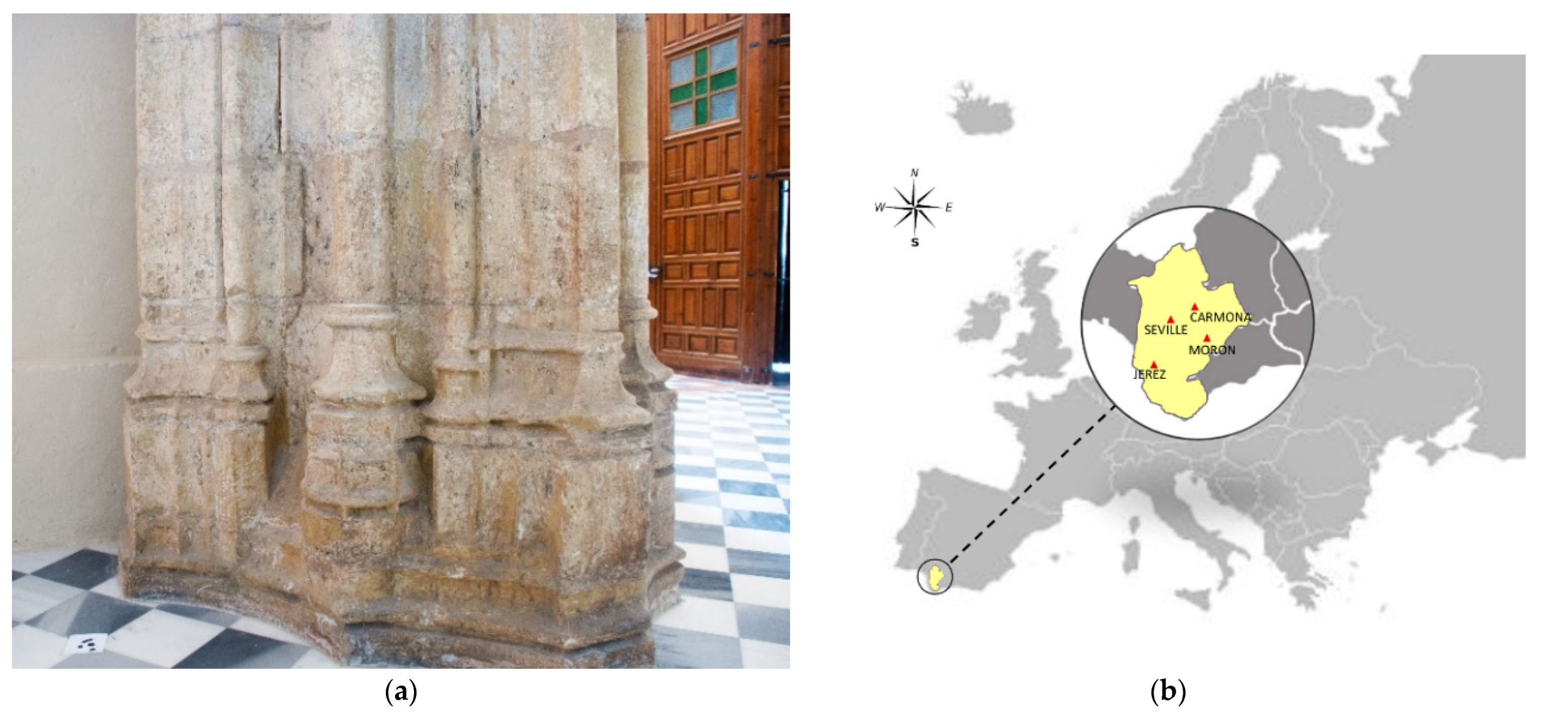
2. Case Studies
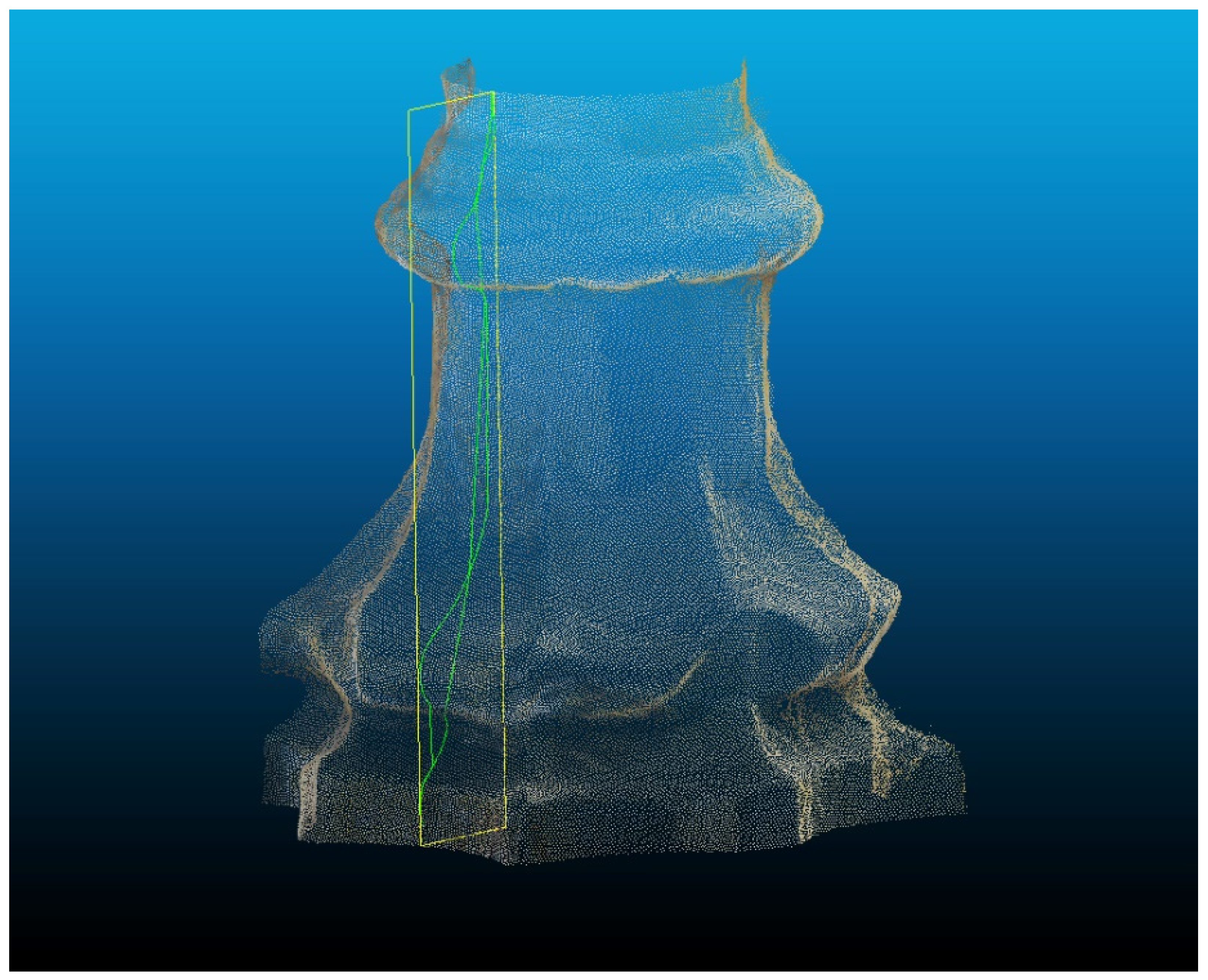
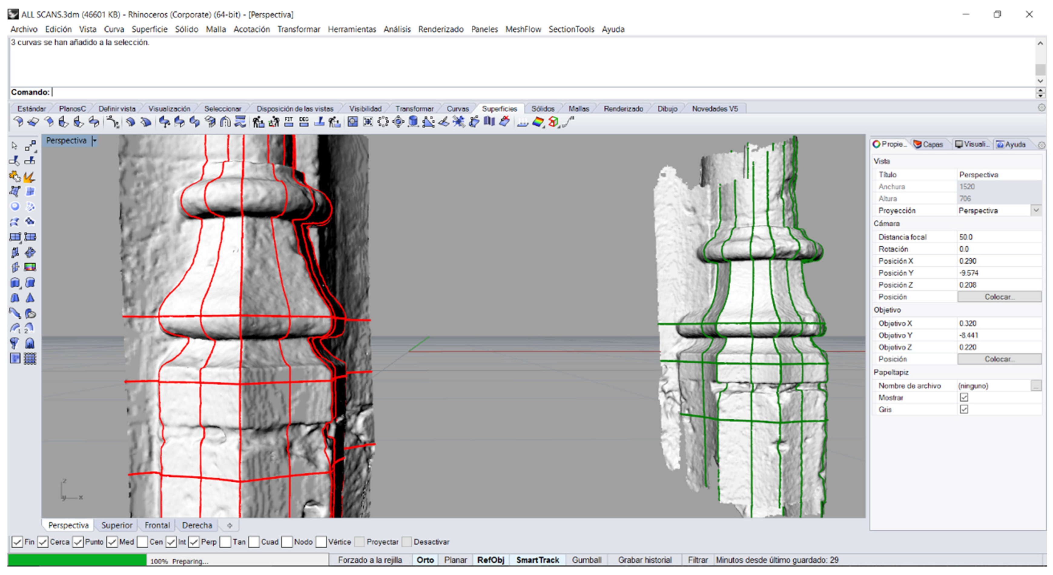
3. Data Acquisition
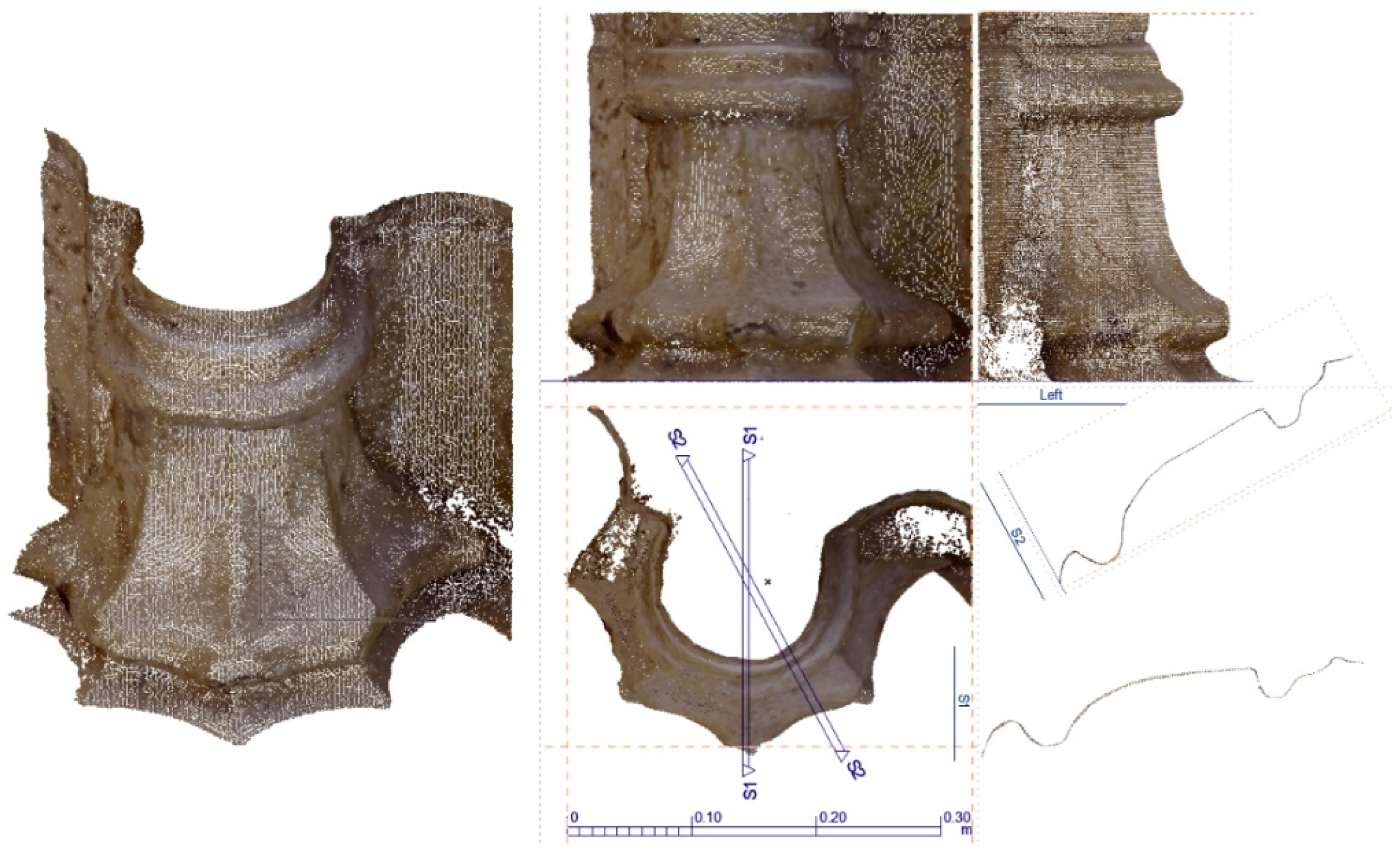
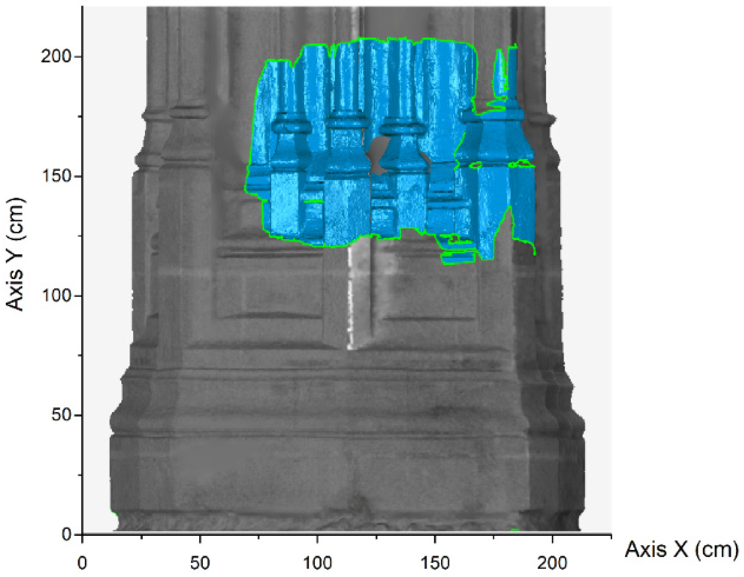
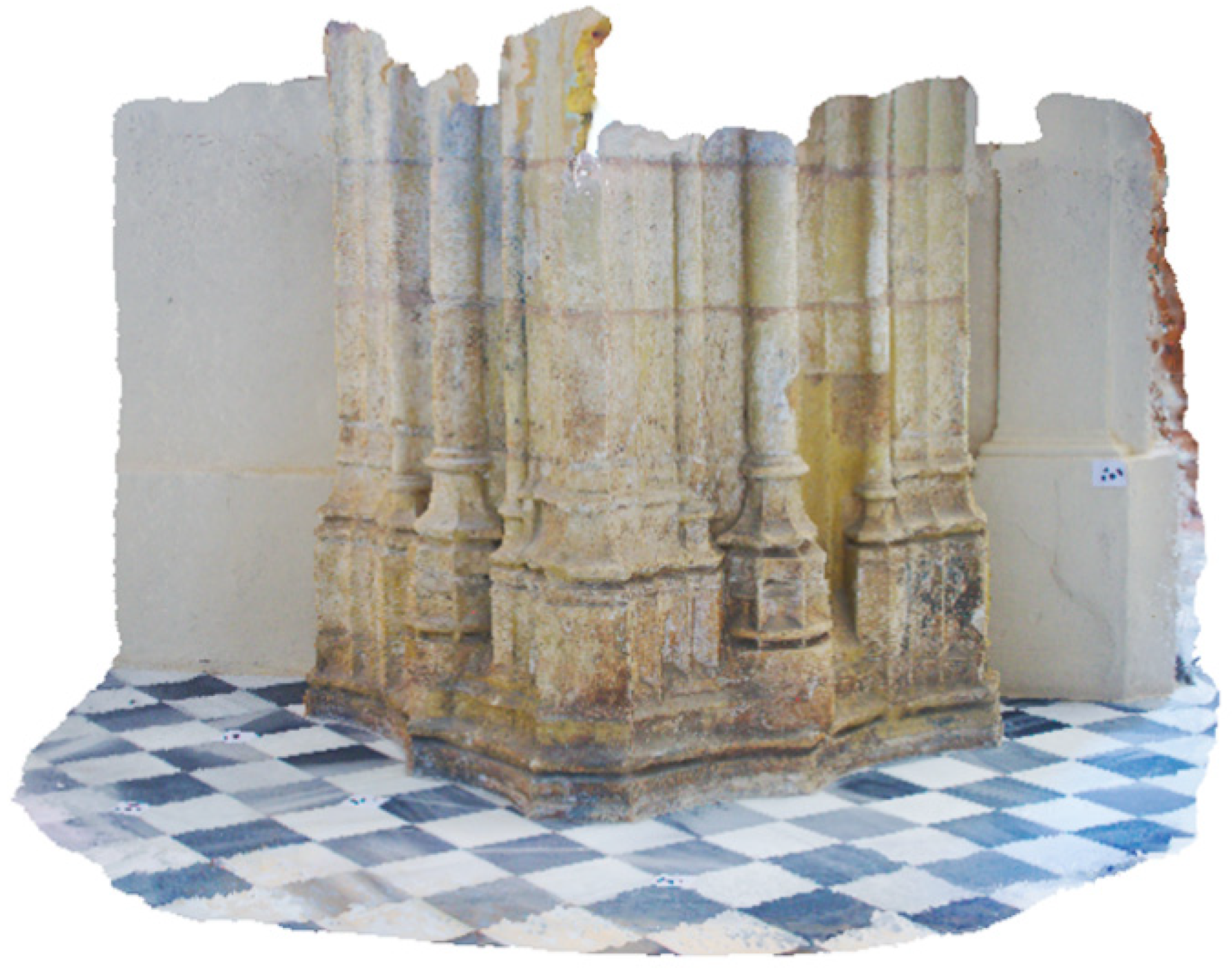
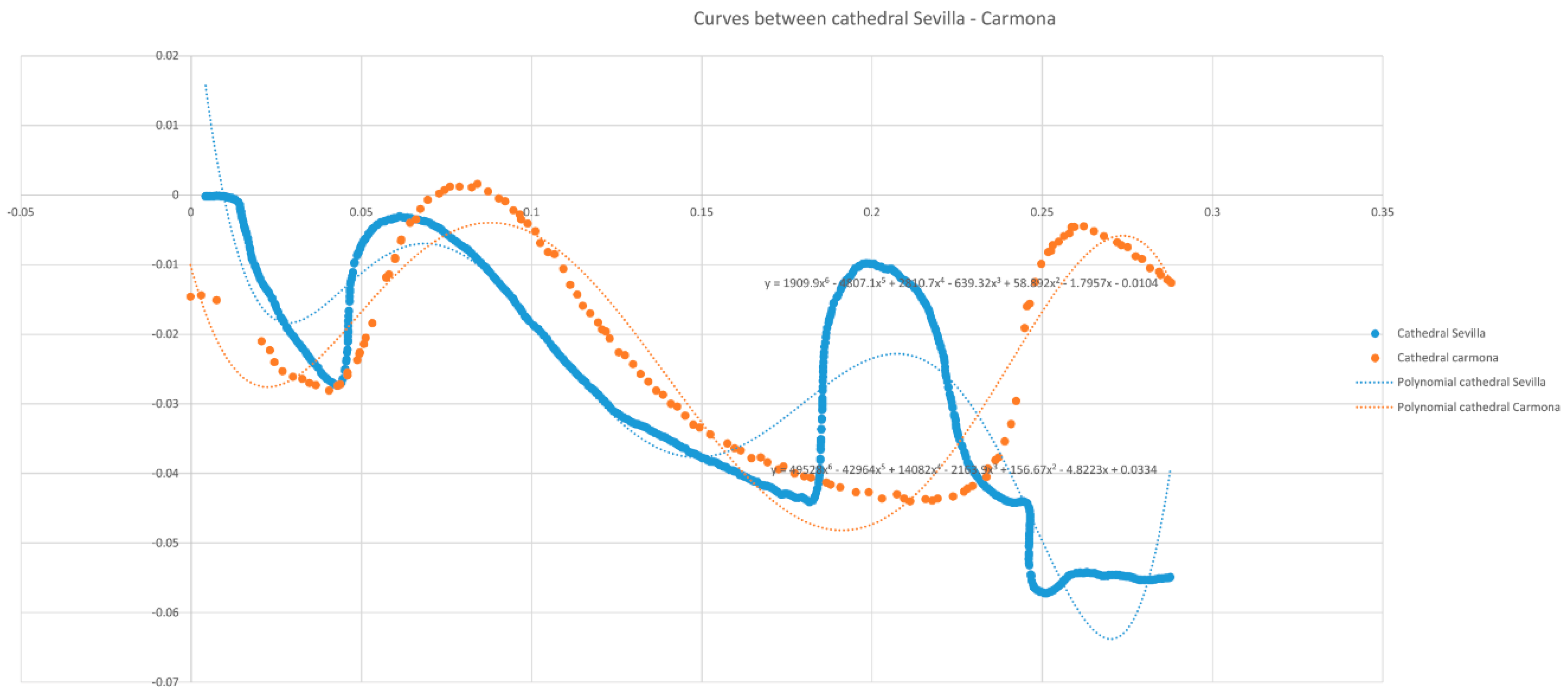
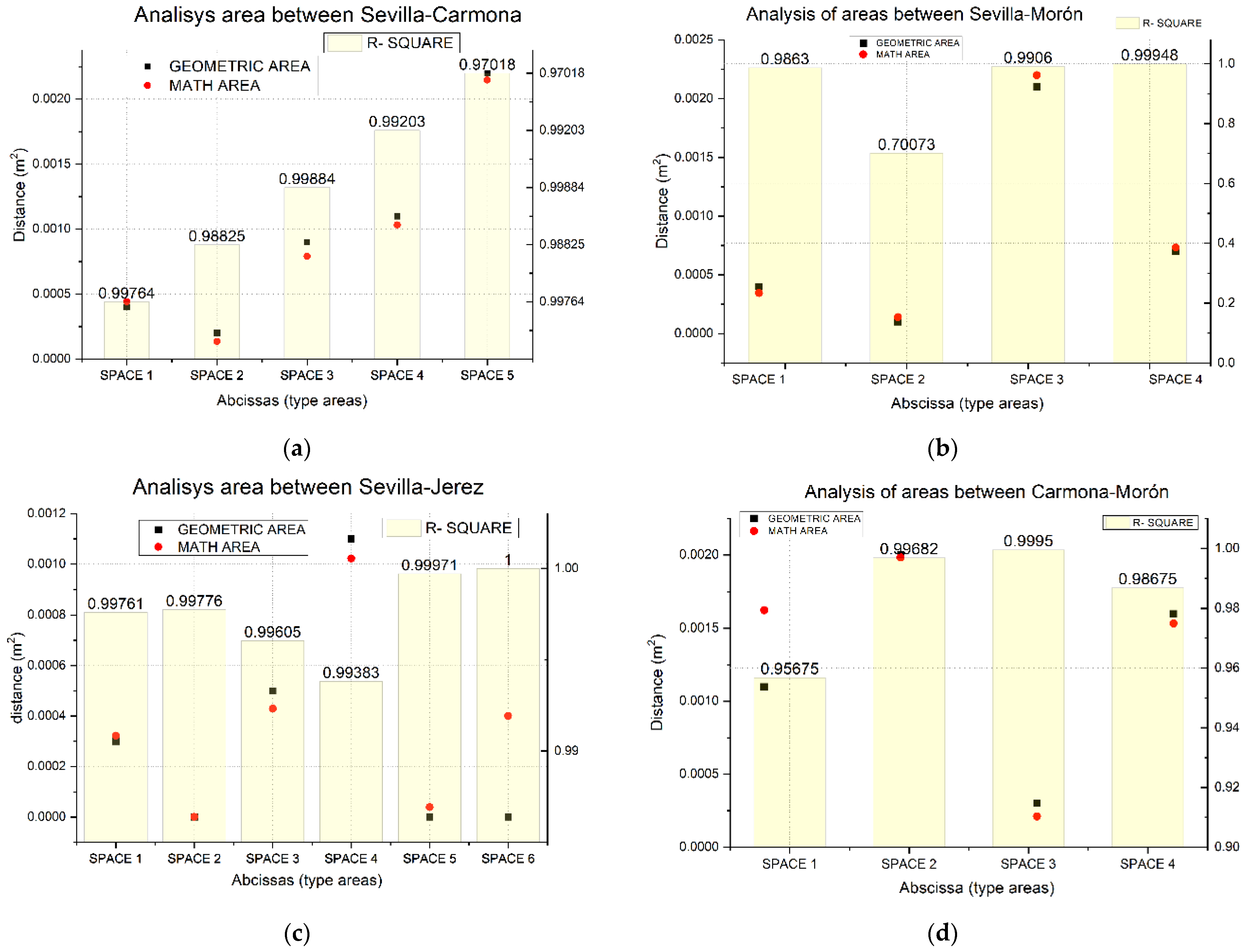
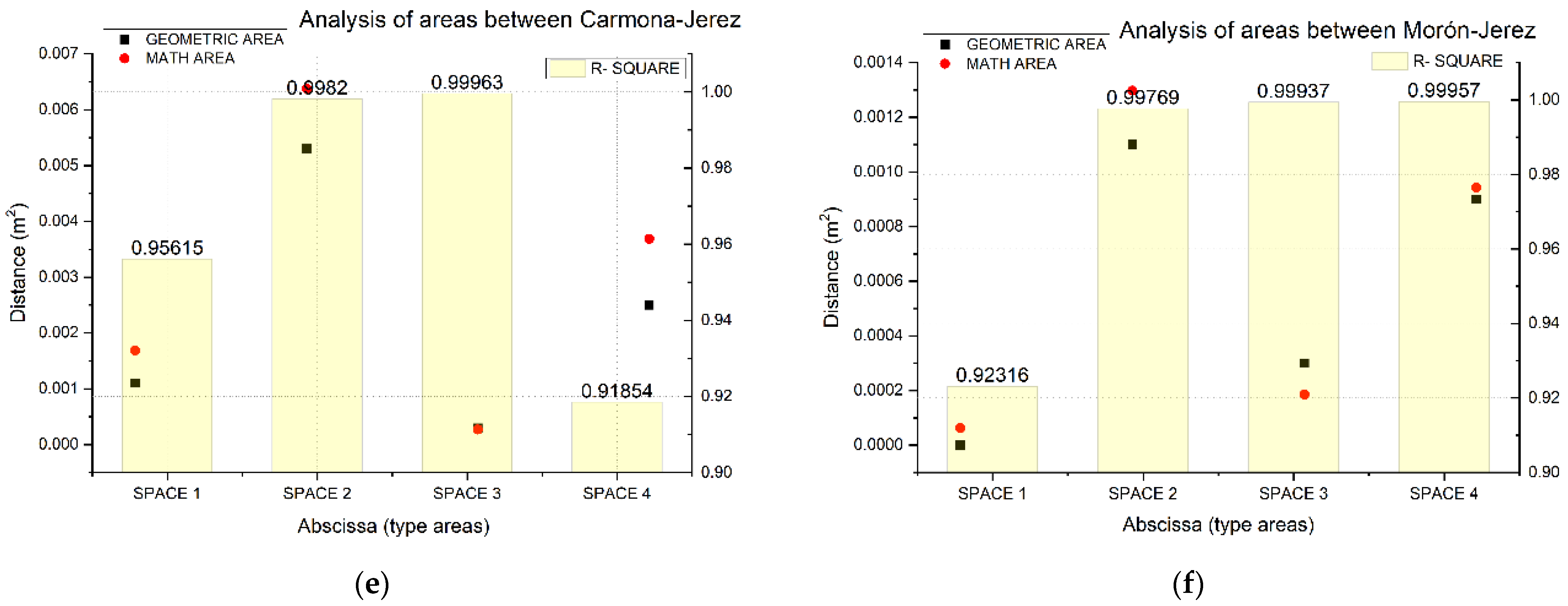
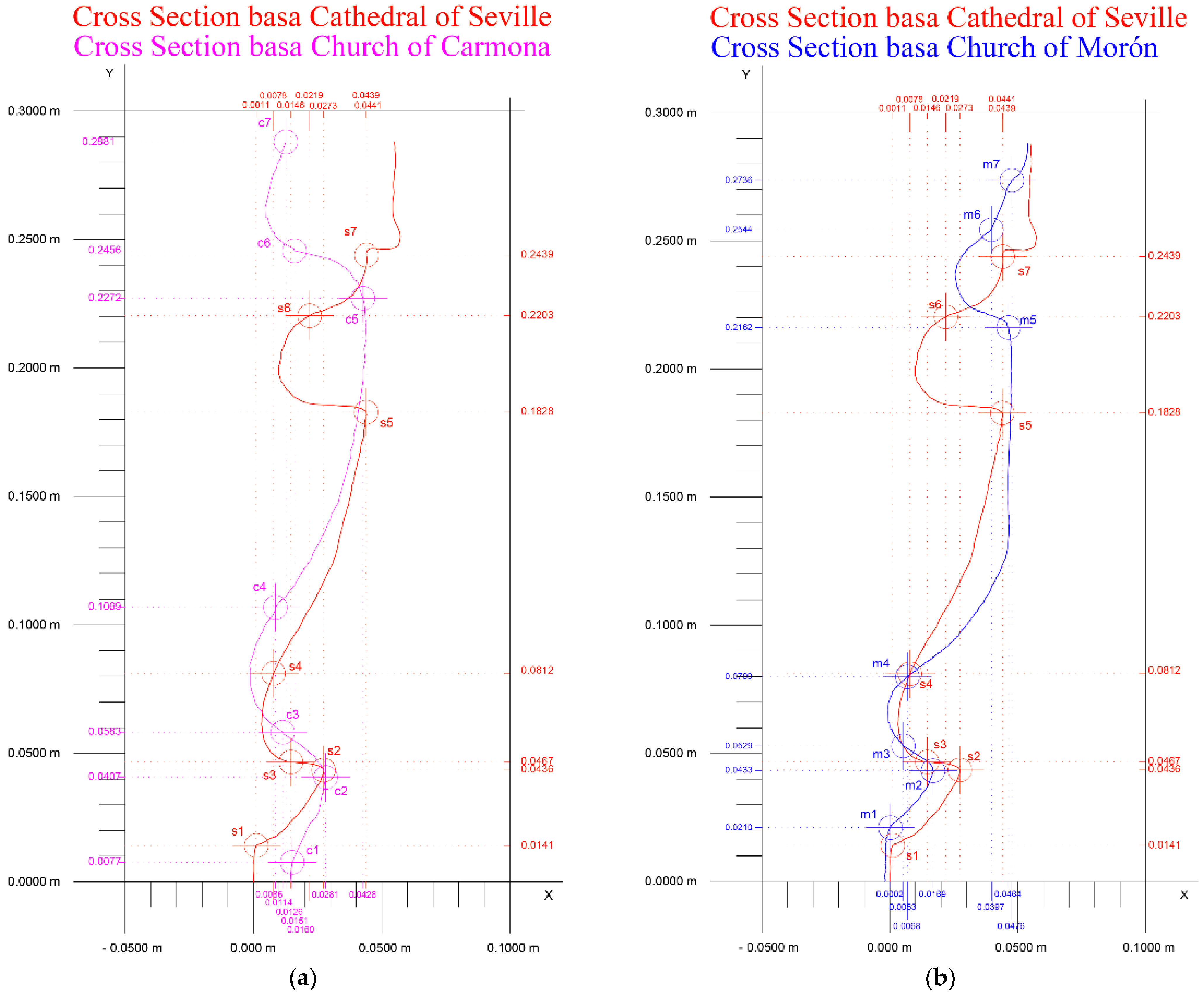
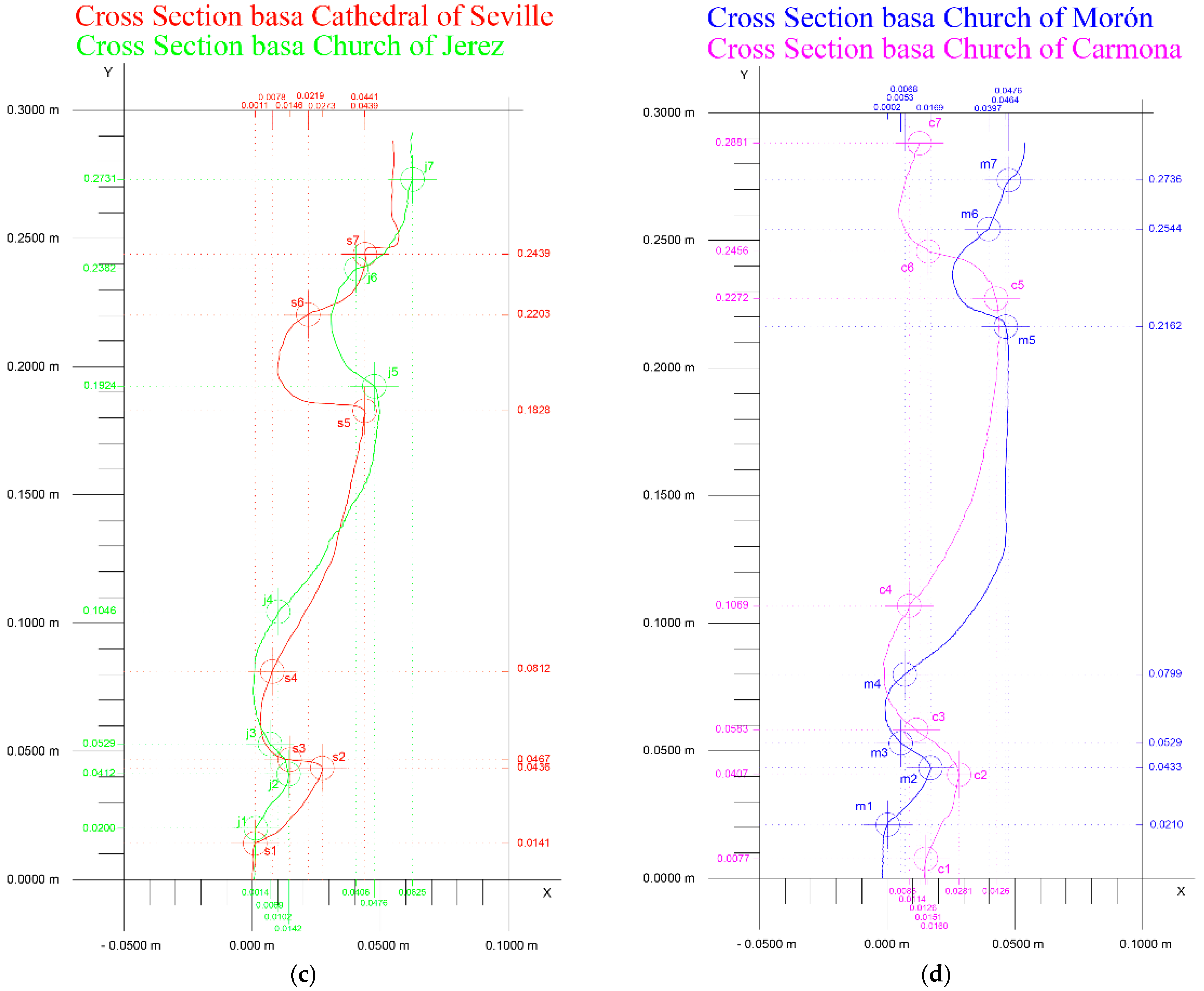
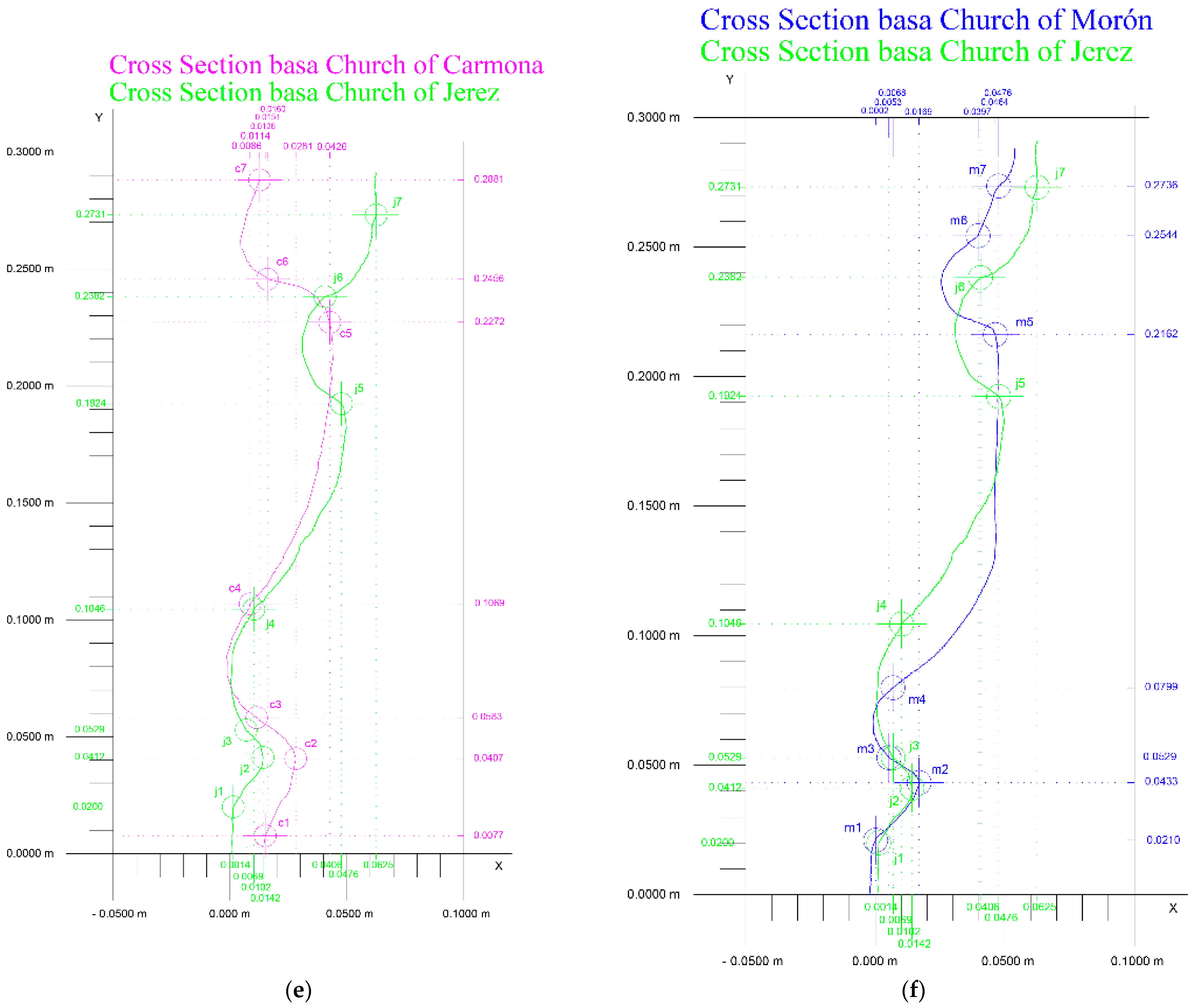
4. Methodological Analysis and Results
5. Discussion of Results
6. Conclusions
Author Contributions
Funding
Data Availability Statement
Conflicts of Interest
References
- Cursi, S.; Simeone, D.; Toldo, I. A semantic web approach for built heritage representation. In Proceedings of the International Conference on Computer-Aided Architectural Design Futures, São Paulo, Brazil, 8–10 July 2015; Volume 527, pp. 383–401. [Google Scholar]
- Dore, C.; Murphy, M. Semi-Automatic Modelling of Building Façades with Shape Grammars Using Historic Building Information Modelling. ISPRS-Int. Arch. Photogramm. Remote Sens. Spat. Inf. Sci. 2013, XL-5/W1, 57–64. [Google Scholar] [CrossRef]
- Pieraccini, M.; Guidi, G.; Atzeni, C. 3D digitizing of cultural heritage. J. Cult. Herit. 2001, 2, 63–70. [Google Scholar] [CrossRef]
- Yilmaz, H.M.; Yakar, M.; Gulec, S.A.; Dulgerler, O.N. Importance of digital close-range photogrammetry in documentation of cultural heritage. J. Cult. Herit. 2007, 8, 428–433. [Google Scholar] [CrossRef]
- Pavlidis, G.; Koutsoudis, A.; Arnaoutoglou, F.; Tsioukas, V.; Chamzas, C. Methods for 3D digitization of Cultural Heritage. J. Cult. Herit. 2007, 8, 93–98. [Google Scholar] [CrossRef]
- Mostaza, T.; Julio, P.J.; Jimeno, Z.; López, J.; Artemio, Q.; Tejera, M. Application of the Scanner Laser 3D to the Spatial Documentation of Archaeological. In Proceedings of the VIII CIA Pósters Teledetección, Teruel, Spain; 2009; pp. 403–408. [Google Scholar]
- Mañana-Borrazás, P.; Rodríguez-Paz, A.; Blanco-Rotea, R. An experience in the application of the 3D Laser Scanner to the documentation and analysis processes of Built Heritage: Its application to Santa Eulalia de Bóveda (Lugo) and San Fiz de Solovio (Santiago de Compostela). Arqueol. Arquit. 2008, 15–32. [Google Scholar] [CrossRef]
- Almagro Gorbea, A. Planimetry of the Alcazar of Seville. In Escuela de Estudios Árabes; CSIC: Granada, Spain, 2000; ISBN 84-7170-166-9. [Google Scholar]
- González Muñoz, M.J.; Rueda Ruiz, A.J.; Segura Sánchez, R.J.; Ogáyar Anguita, C.J.; Esteban Hoyas, A.; Lara, J. Use of 3D scanner-based systems for digitization and study of archaeological heritage. Virtual Archaeol. Rev. 2010, 1, 99. [Google Scholar] [CrossRef]
- Capolupo, A. Accuracy Assessment of Cultural Heritage Models Extracting 3D Point Cloud Geometric Features with RPAS SfM-MVS and TLS Techniques. Drones 2021, 5, 145. [Google Scholar] [CrossRef]
- Pepe, M.; Fregonese, L.; Crocetto, N. Use of SfM-MVS approach to nadir and oblique images generated throught aerial cameras to build 2.5D map and 3D models in urban areas. Geocarto Int. 2019, 37, 120–141. [Google Scholar] [CrossRef]
- Tavani, S.; Granado, P.; Riccardi, U.; Seers, T.; Corradetti, A. Terrestrial SfM-MVS photogrammetry from smartphone sensors. Geomorphology 2020, 367, 107318. [Google Scholar] [CrossRef]
- Wenzel, K.; Rothermel, M.; Fritsch, D.; Haala, N.; Wenzel, K.; Rothermel, M.; Fritsch, D.; Haala, N. Image Acquisition and Model Selection for Multi-View Stereo. ISPAr 2013, XL5, 251–258. [Google Scholar] [CrossRef] [Green Version]
- Teza, G.; Pesci, A.; Ninfo, A. Morphological Analysis for Architectural Applications: Comparison between Laser Scanning and Structure-from-Motion Photogrammetry. J. Surv. Eng. 2016, 142, 04016004. [Google Scholar] [CrossRef]
- Koutsoudis, A.; Vidmar, B.; Ioannakis, G.; Arnaoutoglou, F.; Pavlidis, G.; Chamzas, C. Multi-image 3D reconstruction data evaluation. J. Cult. Herit. 2014, 15, 73–79. [Google Scholar] [CrossRef]
- Westoby, M.J.; Brasington, J.; Glasser, N.F.; Hambrey, M.J.; Reynolds, J.M. ‘Structure-from-Motion’ photogrammetry: A low-cost, effective tool for geoscience applications. Geomorphology 2012, 179, 300–314. [Google Scholar] [CrossRef]
- Müller, P.; Wonka, P.; Haegler, S.; Ulmer, A.; Van Gool, L. Procedural modeling of buildings. In Proceedings of the ACM SIGGRAPH 2006 Papers, SIGGRAPH ’06, Boston, MA, USA, 30 July–3 August 2006; pp. 614–623. [Google Scholar] [CrossRef]
- Osello, A. The future of drawing with BIM for Engineers and Architects; Dario Flaccovio Editore srl.: Palermo, Italy, 2012; pp. 1–323. Available online: http://www.drawingtothefuture.polito.it/wp-content/uploads/2015/09/abstract_9788857901459-2.pdf (accessed on 28 January 2021).
- Andreetto, M.; Brusco, N.; Cortelazzo, G.M. Automatic 3-D modeling of textured cultural heritage objects. IEEE Trans. Image Process. 2004, 13, 354–369. [Google Scholar] [CrossRef] [PubMed]
- Girardeau-Montaut, D. CloudCompare Point Cloud Processing Workshop. Available online: www.cloudcompare.org@CloudCompareGPL (accessed on 28 January 2021).
- Rajendra, Y.D.; Mehrotra, S.C.; Kale, K.V.; Manza, R.R.; Dhumal, R.K.; Nagne, A.D.; Vibhute, A.D.; Rajendra, Y.D.; Mehrotra, S.C.; Kale, K.V.; et al. Evaluation of Partially Overlapping 3D Point Cloud’s Registration by using ICP variant and CloudCompare. ISPAr 2014, 40, 891. [Google Scholar] [CrossRef]
- Bassier, M.; Hadjidemetriou, G.; Vergauwen, M. Implementation of Scan-to-BIM and FEM for the Documentation and Analysis of Heritage Timber Roof Structures. Digit. Herit. Prog. Cult. Herit. Doc. Preserv. Prot. 2016, 1, 79–90. [Google Scholar] [CrossRef]
- Moyano, J.; León, J.; Nieto-Julián, J.E.; Bruno, S. Semantic interpretation of architectural and archaeological geometries: Point cloud segmentation for HBIM parameterisation. Autom. Constr. 2021, 130, 103856. [Google Scholar] [CrossRef]
- Zvietcovich, F.; Castaneda, B.; Perucchio, R. 3D solid model updating of complex ancient monumental structures based on local geometrical meshes. Digit. Appl. Archaeol. Cult. Herit. 2015, 2, 12–27. [Google Scholar] [CrossRef]
- Moyano, J.; Gil-Arizón, I.; Nieto-Julián, J.E.; Marín-García, D. Analysis and management of structural deformations through parametric models and HBIM workflow in architectural heritage. J. Build. Eng. 2021, 45, 103274. [Google Scholar] [CrossRef]
- Li, R.; Luo, T.; Zha, H. 3D Digitization and Its Applications in Cultural Heritage. In Lecture Notes in Computer Science (Including Subseries Lecture Notes in Artificial Intelligence and Lecture Notes in Bioinformatics); Springer: Berlin/Heidelberg, Germany, 2010; Volume 6436 LNCS, pp. 381–388. [Google Scholar] [CrossRef]
- De Reu, J.; Plets, G.; Verhoeven, G.; De Smedt, P.; Bats, M.; Cherretté, B.; De Maeyer, W.; Deconynck, J.; Herremans, D.; Laloo, P.; et al. Towards a three-dimensional cost-effective registration of the archaeological heritage. J. Archaeol. Sci. 2013, 40, 1108–1121. [Google Scholar] [CrossRef]
- Marín-Buzón, C.; Pérez-Romero, A.M.; León-Bonillo, M.J.; Martínez-álvarez, R.; Mejías-García, J.C.; Manzano-Agugliaro, F. Photogrammetry (SfM) vs. Terrestrial Laser Scanning (TLS) for Archaeological Excavations: Mosaic of Cantillana (Spain) as a Case Study. Appl. Sci. 2021, 11, 11994. [Google Scholar] [CrossRef]
- Tsiafakis, D.; Tsirliganis, N.; Pavlidis, G.; Evangelidis, V.; Chamzas, C. Karabournaki-recording the past: The digitization of an archaeological site. In Proceedings of the International Conference on Electronic Imaging & the Visual Arts EVA 2004, Florence, Italy, 29 March–2 April 2004. [Google Scholar]
- Koutsoudis, A.; Chamzas, C. 3D pottery shape matching using depth map images. J. Cult. Herit. 2011, 12, 128–133. [Google Scholar] [CrossRef]
- Zapassky, E.; Finkelstein, I.; Benenson, I. Ancient standards of volume: Negevite Iron Age pottery (Israel) as a case study in 3D modeling. J. Archaeol. Sci. 2006, 33, 1734–1743. [Google Scholar] [CrossRef]
- Karasik, A.; Smilansky, U. 3D scanning technology as a standard archaeological tool for pottery analysis: Practice and theory. J. Archaeol. Sci. 2008, 35, 1148–1168. [Google Scholar] [CrossRef]
- Koutsoudis, A.; Pavlidis, G.; Arnaoutoglou, F.; Tsiafakis, D.; Chamzas, C. Qp: A tool for generating 3D models of ancient Greek pottery. J. Cult. Herit. 2009, 10, 281–295. [Google Scholar] [CrossRef]
- SourceForge QP Real-Time Embedded Frameworks & Tools. Available online: https://sourceforge.net/projects/qpc/files/ (accessed on 28 February 2022).
- Koutsoudis, A.; Pavlidis, G.; Liami, V.; Tsiafakis, D.; Chamzas, C. 3D Pottery content-based retrieval based on pose normalisation and segmentation. J. Cult. Herit. 2010, 11, 329–338. [Google Scholar] [CrossRef]
- Fiorillo, F.; Remondino, F.; Barba, S.; Santoriello, A.; De Vita, C.B.; Casellato, A. 3D digitization and mapping of heritage monuments and comparison with historical drawings. ISPRS-Ann. Photogramm. Remote Sens. Spat. Inf. Sci. 2013, II-5/W1, 2–6. [Google Scholar] [CrossRef]
- Hess, M.; MacDonald, L.W.; Valach, J. Application of multi-modal 2D and 3D imaging and analytical techniques to document and examine coins on the example of two Roman silver denarii. Herit. Sci. 2018, 6, 5. [Google Scholar] [CrossRef] [Green Version]
- Bookstein, F.L. Morphometric Tools for Landmark Data Chapter 1. Introduction. In Morphometric Tools for Landmark Data: Geometry and Biology; Cambrige University Press: Cambrige, UK, 1991; Volume 435. [Google Scholar]
- Zelditch, M.; Swiderski, D.; Sheets, H. Geometric Morphometrics for Biologists; Academic Press: Cambridge, MA, USA, 2012. [Google Scholar] [CrossRef]
- Shott, M.J.; Trail, B.W. Exploring New Approaches to Lithic Analysis: Laser Scanning and Geometric Morphometrics. Lithic Technol. 2016, 35, 195–220. [Google Scholar] [CrossRef]
- Pintus, R.; Pal, K.; Yang, Y.; Weyrich, T.; Gobbetti, E.; Rushmeier, H. A Survey of Geometric Analysis in Cultural Heritage. Comput. Graph. Forum. 2016, 35, 4–31. [Google Scholar] [CrossRef]
- Xue, F.; Lu, W.; Webster, C.J.; Chen, K. A derivative-free optimization-based approach for detecting architectural symmetries from 3D point clouds. ISPRS J. Photogramm. Remote Sens. 2019, 148, 32–40. [Google Scholar] [CrossRef]
- Herrera Gómez, B.; Samper Sosa, A. Sobre La Fractalidad De Los Rosetones Góticos (About the Fraternity of Gothic Rosettes). In Proceedings of the XII Congreso Internacional Expresión Gráfica aplicada a la Edificación—Graphic Expression applied to Building International Conference—APEGA 2014, Madrid, Spain, 26–28 November 2014; Volume 2, pp. 558–571. [Google Scholar]
- Brown, C.T.; Witschey, W.R.T. The fractal geometry of ancient Maya settlement. J. Archaeol. Sci. 2003, 30, 1619–1632. [Google Scholar] [CrossRef]
- Mandelbrot, B.; Mandelbrot, B. The Fractal Geometry of Nature; WH Freeman: New York, NY, USA, 1982. [Google Scholar]
- Moyano, J.J.; Barrera, J.A.; Nieto, J.E.; Marín, D.; Antón, D. A geometrical similarity pattern as an experimental model for shapes in architectural heritage: A case study of the base of the pillars in the Cathedral of Seville and the church of Santiago in Jerez, Spain. ISPRS-Int. Arch. Photogramm. Remote Sens. Spat. Inf. Sci. 2017, XLII-2/W3, 511–517. [Google Scholar] [CrossRef]
- López, J.C. Estereotomía de la Piedra (Stone Stereotomy); COAAT: Murcia, Spain, 2004. [Google Scholar]
- Cruz Isidoro, F. Alonso de Vandelvira (1544-ca. 1626/7): Tratadista y Arquitecto Andaluz (Alonso de Vandelvira (1544-ca. 1626/7): Andalusian writer and architect); Universidad de Sevilla: Sevilla, Spain, 2001; Volume 316. [Google Scholar]
- Morales Martínez, A.J. Hernán Ruiz “El Joven” (Hernan Ruiz ’The Younger’); Ediciones Akal: Akal, Madrid, 1996. [Google Scholar]
- Capilla Tamborero, E. Hypothesis of geometric methods in profiles of voussoirs of ribbed vaults of the monastery of Santa Maria de la Valldigna (Valencia, Spain). In Dibujar, Construir, Soñar. Investigaciones en Torno a la Expresión Gráfica Aplicada a la Edificación/Drawing, Building, Dreaming. Research on Graphic Expression Applied to Building; Tirant lo Blanch: Castellón de la Plana, Spain, 2016; pp. 731–744. [Google Scholar]
- Ruiz de la Rosa, J.A. Execution drawings: Documentary value and way of knowledge of the Cathedral of Seville. In La Catedral Gótica de Sevilla: Fundación y Fábrica de la Obra Nueva; Universidad de Sevilla: Sevilla, Spain, 2007; pp. 297–348. [Google Scholar]
- De Rosa, J.A.R.; Estévez, J.C.R. Round Chapel in a Round Round: New Contributions on a Renaissance Hill in the Cathedral of Seville; Universidad de Sevilla: Sevilla, Spain, 2011. [Google Scholar]
- López Mozo, A.; Rabasa Díaz, E.; Sobrino González, M. The line in the material control of the form. In Proceedings of the Actas del Séptimo Congreso Nacional de Historia de la Construcción, Santiago de Compostela, Santiago, CA, USA, 26–29 October 2011; pp. 743–754. [Google Scholar]
- Boschert, S.; Rosen, R.; Boschert, S.; Rosen, R. Digital Twin—The Simulation Aspect. In Mechatronic Futures: Challenges and Solutions for Mechatronic Systems and Their Designers; Springer International: Heidelberg, Germany, 2016; pp. 59–74. [Google Scholar] [CrossRef]
- Caramazana Malia, D.; Romero Bejarano, M. New data on “the Gothic facades of Cadiz”: The patronage of Cardinal Diego Hurtado de Mendoza in the parish of Santiago de Jerez and the authorship of Rodrigo de Alcalá in the parish of San Jorge de Alcalá de los Gazules. Lab. Arte 2016, 28, 41–60. [Google Scholar] [CrossRef]
- Falcón Márquez, T. The Gothic Building, the Cathedral of Seville; Guadalquivir, S.L., Ed.; Ediciones: Sevilla, Spain, 1991. [Google Scholar]
- Pinto Puerto, F.; Guerrero Vega, J.M. Estudios previos a la intervención en la capilla de la antigua iglesia de San Miguel, en Morón de la Frontera (Sevilla) (Studies prior to the intervention in the chapel of the old church of San Miguel, in Morón de la Frontera (Seville)). Arqueol. Arquit. 2009, 6, 267–286. [Google Scholar] [CrossRef]
- Ojeda Barrera, A. The work of the primitive chapel of the Tabernacle of Santa María de Carmona. Lab. Arte 2014, 26, 73–93. [Google Scholar]
- Pomar Rodil, P.J. La pervivencia de la técnica medieval en la arquitectura andaluza: La Catedral de Jerez de la Frontera (Cádiz), una construcción “gótica” del pleno Barroco. In Proceedings of the Actas del Tercer Congreso Nacional de Historia de la Construcción, Sevilla, Spain, 26–28 October 2000; Volume 2, pp. 841–852, ISBN 84-95365-56-1. [Google Scholar]
- Juan Carlos RUIZ SOUZA y Antonio GARCÍA FLORES Ysambart y la renovación del gótico final en Castilla: Palencia, la Capilla del Contador Saldaña en Tordesillas y Sevilla. Hipótesis para el debate. An. De Hist. Del Arte 2009, 19, 43–76.
- Coveney, S.; Stewart Fotheringham, A.; Charlton, M.; McCarthy, T. Dual-scale validation of a medium-resolution coastal DEM with terrestrial LiDAR DSM and GPS. Comput. Geosci. 2010, 36, 489–499. [Google Scholar] [CrossRef]
- Forlani, G.; Pinto, L.; Roncella, R.; Pagliari, D. Terrestrial photogrammetry without ground control points. Earth Sci. Inform. 2014, 7, 71–81. [Google Scholar] [CrossRef]
- dos Santos, D.R.; Dal Poz, A.P.; Khoshelham, K. Indirect Georeferencing of Terrestrial Laser Scanning Data using Control Lines. Photogramm. Rec. 2013, 28, 276–292. [Google Scholar] [CrossRef]
- Akca, D.; Freeman, M. Quality assessment of 3D building data. Photogramm. Rec. 2010, 25, 339–355. [Google Scholar] [CrossRef]
- Moyano, J.; Nieto-Julián, J.E.; Bienvenido-Huertas, D.; Marín-García, D. Validation of Close-Range Photogrammetry for Architectural and Archaeological Heritage: Analysis of Point Density and 3d Mesh Geometry. Remote Sens. 2020, 12, 3571. [Google Scholar] [CrossRef]
- Gonçalves, J.A.; Henriques, R. UAV photogrammetry for topographic monitoring of coastal areas. ISPRS J. Photogramm. Remote Sens. 2015, 104, 101–111. [Google Scholar] [CrossRef]
- Campos, M.; Tommaselli, A.; Ivánová, I.; Billen, R. Data Product Specification Proposal for Architectural Heritage Documentation with Photogrammetric Techniques: A Case Study in Brazil. Remote Sens. 2015, 7, 13337–13363. [Google Scholar] [CrossRef]
- David, P.H. Darktable. Available online: https://www.darktable.org/ (accessed on 30 January 2020).
- Agisoft PhotoScan Software. Agisoft Metashape. Available online: https://www.agisoft.com/ (accessed on 30 January 2020).
- Geosystems Leica Geosystems (2008) Leica FlexLine TS02/TS06/TS09 User Manual. Available online: https://leica-geosystems.com/ (accessed on 16 March 2020).
- Moyano, J.; Nieto-Julián, J.E.; Antón, D.; Cabrera, E.; Bienvenido-Huertas, D.; Sánchez, N. Suitability Study of Structure-from-Motion for the Digitisation of Architectural (Heritage) Spaces to Apply Divergent Photograph Collection. Symmetry 2020, 12, 1981. [Google Scholar] [CrossRef]
- Jaud, M.; Passot, S.; Allemand, P.; Le Dantec, N.; Grandjean, P.; Delacourt, C. Suggestions to Limit Geometric Distortions in the Reconstruction of Linear Coastal Landforms by SfM Photogrammetry with PhotoScan® and MicMac® for UAV Surveys with Restricted GCPs Pattern. Drones 2019, 3, 2. [Google Scholar] [CrossRef]
- Guarnieri, A.; Remondino, F.; Vettore, A. Digital Photogrammetry and Tls Data Fusion Applied To Cultural Heritage 3D Modeling. Int. Arch. Photogramm. Remote Sens. Spat. Inf. Sci. 2006, 36, 1–6. [Google Scholar]
- Seminati, E.; Talamas, D.C.; Young, M.; Twiste, M.; Dhokia, V.; Bilzon, J.L.J. Validity and reliability of a novel 3D scanner for assessment of the shape and volume of amputees’ residual limb models. PLoS ONE 2017, 12, e0184498. [Google Scholar] [CrossRef]
- Psikuta, A.; Frackiewicz-Kaczmarek, J.; Mert, E.; Bueno, M.A.; Rossi, R.M. Validation of a novel 3D scanning method for determination of the air gap in clothing. Measurement 2015, 67, 61–70. [Google Scholar] [CrossRef]
- Kim, D.H.; Gratchev, I. Application of Optical Flow Technique and Photogrammetry for Rockfall Dynamics: A Case Study on a Field Test. Remote Sens. 2021, 13, 4124. [Google Scholar] [CrossRef]
- Hild, F.; Roux, S. Comparison of Local and Global Approaches to Digital Image Correlation. Exp. Mech. 2012, 52, 1503–1519. [Google Scholar] [CrossRef]
- Chou, P.A.; Koroteev, M.; Krivokuca, M. A Volumetric Approach to Point Cloud Compression—Part I: Attribute Compression. IEEE Trans. Image Process. 2020, 29, 2203–2216. [Google Scholar] [CrossRef]
- Mémoli, F.; Sapiro, G. Comparing Point Clouds. In Proceedings of the 2004 Eurographics/ACM SIGGRAPH Symposium on Geometry Processing—SGP, Nice, France, 8–10 July 2004. [Google Scholar] [CrossRef]
- Agisoft PhotoScan Software. Agisoft PhotoScan. Available online: https://www.agisoft.es/products/agisoft-photoscan/ (accessed on 9 May 2019).
- Antón, D.; Medjdoub, B.; Shrahily, R.; Moyano, J. Accuracy evaluation of the semi-automatic 3D modeling for historical building information models. Int. J. Archit. Herit. 2018, 12, 790–805. [Google Scholar] [CrossRef]
- Arias, P.; Ordóñez, C.; Lorenzo, H.; Herraez, J. Methods for documenting historical agro-industrial buildings: A comparative study and a simple photogrammetric method. J. Cult. Herit. 2006, 7, 350–354. [Google Scholar] [CrossRef]
- Lane, S.N.; James, T.D.; Crowell, M.D. Application of digital photogrammetry to complex topography for geomorphological research. Photogramm. Rec. 2000, 16, 793–821. [Google Scholar] [CrossRef]
- Pielke, R.A. Mesoscale Meteorological Modeling, 3rd ed.; Academic Press: Cambridge, UK, 1984. [Google Scholar]
- Olivier, M.D.; Robert, S.; Richard, A.F. A method to quantify canopy changes using multi-temporal terrestrial lidar data: Tree response to surrounding gaps. Agric. For. Meteorol. 2017, 237, 184–195. [Google Scholar] [CrossRef]
- Dabbour, L.M. Geometric proportions: The underlying structure of design process for Islamic geometric patterns. Front. Archit. Res. 2012, 1, 380–391. [Google Scholar] [CrossRef]
- Chiabrando, F.; Lingua, A.; Noardo, F.; Spanò, A. 3D modelling of trompe l’oeil decorated vaults using dense matching techniques. Int. Arch. Photogramm Remote Sens. Spat. Inf. Sci. 2014, 2, 97–104. [Google Scholar] [CrossRef] [Green Version]
- Gruen, A.; Akca, D. Least squares 3D surface and curve matching. ISPRS J. Photogramm. Remote Sens. 2005, 59, 151–174. [Google Scholar] [CrossRef]
- Remondino, F.; Spera, M.; Nocerino, E. State of the art in high density image matching. Photogramm. Rec. 2014, 29, 144–166. [Google Scholar] [CrossRef]
- Yang, J.; Kang, Z.; Cheng, S.; Yang, Z.; Akwensi, P.H. An Individual Tree Segmentation Method Based on Watershed Algorithm and Three-Dimensional Spatial Distribution Analysis From Airborne LiDAR Point Clouds. IEEE J. Sel. Top. Appl. Earth Obs. Remote Sens. 2020, 13, 1055–1067. [Google Scholar] [CrossRef]
- OriginLab OriginPro—Data Analysis and Graphing Software; OriginLab: Northampton, MA, USA, 2021.
- Robert McNeel & Associates Rhinoceros. Available online: https://www.rhino3d.com/ (accessed on 27 March 2020).
- Gines, J.L.C.; Cervera, C.B. Toward Hybrid Modeling and Automatic Planimetry for Graphic Documentation of the Archaeological Heritage: The Cortina Family Pantheon in the Cemetery of Valencia. Int. J. Archit. Herit. 2019, 14, 1210–1220. [Google Scholar] [CrossRef]
- Teppati Losè, L.; Chiabrando, F.; Spanò, A.; Teppati Losè, L.; Chiabrando, F.; Spanò, A. Preliminary Evaluation of a Commercial 360 Multi-Camera Rig for Photogrammetric Purposes. ISPAr 2018, 422, 1113–1120. [Google Scholar] [CrossRef]
- Wang, J.; Shahbazi, M.; Wang, J.; Shahbazi, M. Mapping Quality Evaluation of Monocular Slam Solutions for Micro Aerial Vehicles. ISPAr 2019, 4217, 413–420. [Google Scholar] [CrossRef]
- Marques, A.; Kenji Horota, R.; De Souza, E.M.; Rossa, P.; Aires, A.S.; Roberto Veronez, M.; Gonzaga, L.; Lessio Cazarin, C. Skewness-Adjusted Robust Statistical Assessment on Googles Earth 3D Models: Rapplee Ridge. In Proceedings of the International Geoscience and Remote Sensing Symposium (IGARSS), Yokohama, Japan, 28 July–2 August 2019; pp. 4348–4351. [Google Scholar] [CrossRef]
- De Luca, L.; Veron, P.; Florenzano, M. Reverse engineering of architectural buildings based on a hybrid modeling approach. Comput. Graph. 2006, 30, 160–176. [Google Scholar] [CrossRef]
- Brumana, R.; Oreni, D.; Raimondi, A.; Georgopoulos, A.; Bregianni, A. From survey to HBIM for documentation, dissemination and management of built heritage: The case study of St. Maria in Scaria d’Intelvi. In Proceedings of the 2013 Digital Heritage International Congress (DigitalHeritage), Marseille, France, 28 October–1 November 2013; Volume 1, pp. 497–504. [Google Scholar]
- David Lo Buglio, L.D.L. Representation of architectural artifacts definition of an approach combining the complexity of the 3D digital instance with the intelligibility of the theoretical model. Sci. Res. Inf. Technol. 2012, 2, 63–76. [Google Scholar] [CrossRef]
- Tommasi, C.; Achille, C.; Fassi, F. From point cloud to BIM: A modelling challenge in the Cultural Heritage field. Isprs-Int. Arch. Photogramm. Remote Sens. Spat. Inf. Sci. 2016, XLI-B5, 429–436. [Google Scholar] [CrossRef] [Green Version]
- Bay, H.; Ess, A.; Tuytelaars, T.; Van Gool, L. Speeded-Up Robust Features (SURF). Comput. Vis. Image Underst. 2008, 110, 346–359. [Google Scholar] [CrossRef]
- Daponte, P.; De Vito, L.; Mazzilli, G.; Picariello, F.; Rapuano, S. A height measurement uncertainty model for archaeological surveys by aerial photogrammetry. Measurement 2017, 98, 192–198. [Google Scholar] [CrossRef]
- Ramón Parra-Michel, J.; Martínez García, A.; Martínez, J.A. Standard uncertainty calculation by Monte Carlo technique for topography and hole-filed displacement measurement means ESPI. Nova Sci. 2013, 5, 51–75. [Google Scholar]

| Experimental Surveys | Standart Deviation (σ) (m) | RMS (m) | Min. Distance (m) | Max. Distance (m) | Average Distance (m) | Estimated Standard Error (m) |
|---|---|---|---|---|---|---|
| C. Sevilla-C. Carmona | 0.0110 | 0.0120 | 0 | 0.0440 | 0.0120 | 0.0010 |
| C. Sevilla-C. Morón | 0.0080 | 0.0110 | 0 | 0.0360 | 0.0080 | 0.0010 |
| C. Sevilla-C. Jerez | 0.0060 | 0.0060 | 0 | 0.0260 | 0.0060 | 0.0010 |
| C. Carmona-C. Morón | 0.0100 | 0.0080 | 0 | 0.0380 | 0.0130 | 0.0010 |
| C. Carmona-C. Jerez | 0.0150 | 0.0110 | 0 | 0.0520 | 0.0120 | 0.0010 |
| C. Jerez-C. Morón | 0.0060 | 0.0090 | 0 | 0.0180 | 0.0080 | 0.0010 |
| Experimental Surveys | Geometric Area (m²) | Mathematic Area (m²) | Average Distance | Estimated Standard Error (m) |
|---|---|---|---|---|
| C. Sevilla-C. Carmona | −0.0014 | −0.0013 | −0.0014 | 0.0001 |
| C. Sevilla-C. Morón | −0.0009 | −0.0010 | −0.0009 | 0.0001 |
| C. Sevilla-C. Jerez | −0.0013 | −0.0015 | −0.0014 | 0.0001 |
| C. Carmona-C. Morón | −0.0022 | −0.0017 | −0.0019 | 0.0004 |
| C. Carmona-C. Jerez | −0.0064 | −0.0081 | −0.0073 | 0.0012 |
| C. Jerez-C. Morón | −0.0005 | −0.0005 | −0.0005 | 0.0000 |
Publisher’s Note: MDPI stays neutral with regard to jurisdictional claims in published maps and institutional affiliations. |
© 2022 by the authors. Licensee MDPI, Basel, Switzerland. This article is an open access article distributed under the terms and conditions of the Creative Commons Attribution (CC BY) license (https://creativecommons.org/licenses/by/4.0/).
Share and Cite
Moyano, J.; Fernández-Alconchel, M.; Nieto-Julián, J.E.; Carretero-Ayuso, M.J. Methodologies to Determine Geometrical Similarity Patterns as Experimental Models for Shapes in Architectural Heritage. Symmetry 2022, 14, 1893. https://doi.org/10.3390/sym14091893
Moyano J, Fernández-Alconchel M, Nieto-Julián JE, Carretero-Ayuso MJ. Methodologies to Determine Geometrical Similarity Patterns as Experimental Models for Shapes in Architectural Heritage. Symmetry. 2022; 14(9):1893. https://doi.org/10.3390/sym14091893
Chicago/Turabian StyleMoyano, Juan, María Fernández-Alconchel, Juan E. Nieto-Julián, and Manuel J. Carretero-Ayuso. 2022. "Methodologies to Determine Geometrical Similarity Patterns as Experimental Models for Shapes in Architectural Heritage" Symmetry 14, no. 9: 1893. https://doi.org/10.3390/sym14091893
APA StyleMoyano, J., Fernández-Alconchel, M., Nieto-Julián, J. E., & Carretero-Ayuso, M. J. (2022). Methodologies to Determine Geometrical Similarity Patterns as Experimental Models for Shapes in Architectural Heritage. Symmetry, 14(9), 1893. https://doi.org/10.3390/sym14091893