Article

Transformations in the Agricultural and Scenic Landscapes in the Northwest of the Region of Murcia (Spain): Moving towards Long Awaited (Un)Sustainability

by
Ramón García-Marín
*,
Cayetano Espejo-Marín
,
Rubén Giménez-García
and
Víctor Ruiz-Álvarez
Department of Geography, University of Murcia, 30001 Murcia, Spain
*
Author to whom correspondence should be addressed.
Land 2020, 9(9), 314; https://doi.org/10.3390/land9090314
Submission received: 3 July 2020 / Revised: 20 August 2020 / Accepted: 3 September 2020 / Published: 4 September 2020

Abstract

:
Since the middle of the 20th century, irrigation in the southeast of Spain has displayed significant productive growth based on the intensive use of the scarce water resources in the area and the contribution of river flows from the hydrographic basin of the Tagus River to the hydrographic basin of the Segura River. Despite high levels of efficiency in the water use from the new irrigation systems, the water deficit has only intensified in recent years. The most dynamically irrigated areas (Campo de Cartagena, Valle del Guadalentín, Vega Alta del Segura and the southern coast of the Region of Murcia), were faced with a complex and trying future, resulting in numerous companies (agribusinesses) relocating to lease and acquire land in the northwest of Murcia to develop their intensive crops. The general objective of this article lies in the analysis of widespread landscape dynamics, and of agricultural dynamics in particular, in the rural environment of the northwest Region of Murcia (Spain). For this, an exhaustive analysis of the land cover and use transformations is carried out for the periods of time 1990–2000–2012–2018. The data studied come from the Corine Land Cover (CLC) project, carried out by the European Environment Agency (EEA). These spatial data are treated with geographical information systems (GISs) and represented by statistical and cartographic analyses and cross-tabulation matrices that indicate the dynamics of changes, loss and land gain. As the main result, we find that the areas occupied by new intensive irrigation on old rainfed farmland in the northwest Region of Murcia have increased in the last 30 years. Traditional irrigation is disappearing, and the environmental consequences (overexploitation of aquifers and decreased flows from natural sources), among others, are dire.

1. Introduction

Agriculture is the sector that consumes the most water and at the same time is the most affected by the scarcity of water in many places; it represents 70.0% of the world’s freshwater withdrawals and more than 90.0% of its consumption [1,2]. Agriculture is responsible for just over 80.0% of the hydrological footprint in Spain [3]. According to United Nations forecasts, by 2030, freshwater resources will decrease by 40.0% [4]. This fact, together with the increase in the world population, could generate a global water crisis. In this way, policies must be directed towards the sustainability of agricultural activities and the reduction in water consumption by crops [5].
The southeast of the Iberian Peninsula is undoubtedly the climatic region in Spain where avant-garde agriculture is most significant [6,7,8]. Throughout the second half of the 20th century, and particularly over the last three decades, innovation and new technologies have made overcoming the disadvantages of the climate possible. Scarce and irregular rainfall have led to a shortage of its own water resources. Today, those who follow new agricultural production systems, whether in greenhouses or in the open air, with high-frequency localised irrigation, crave water brought in from considerable distances (The Tajo–Segura Aqueduct), but not rain in situ, which stains the fruit, favours pests or causes damage in greenhouses. Thus, from this perspective, the scarcity of rain becomes an advantage for this new agriculture [9]. However, the water deficit has intensified in recent years, as irrigated areas continue to increase [10].
The scarcity of water resources has predominantly been defined as an emergency situation in the Spanish Southeast, a climatic region with semiarid characteristics which is in agreement with an overall traditional approach to water policies. It is also true that more or less at the same time as the WFD (Water Framework Directive) was published, a new, albeit limited in scope, trend started emerging. This new approach integrates the scarcity of water resources into planning policies and incorporates risk assessment as one possible scenario. The context within which this new approach developed was no longer characterised only by the traditional water policy paradigm reflected in the LPHN (National Hydrological Plan Law) (Ley 10/2001, de 5 de julio), the most emblematic infrastructure of which was the so-called “Ebro water transfer” [11,12]. During the late 1990s, a regionalist paradigm—characterised by the political use of water resources by different regional governments (Region of Murcia, among other Autonomous Communities), and a new water culture paradigm, which aimed to change traditional policies—also emerged [13,14], facilitating a change in the general direction of water policy [15], as represented by the publication of the AGUA (Actions for the Management and Use of Water) programme in 2004 [16,17,18]. Without abandoning the traditional objective—the generation of new resources, the programme stresses the importance of water treatment, reuse and the construction of large desalinisation plants, instead of large hydraulic infrastructures that promote inter-regional conflict. Despite the different policies and actions, the demands for water resources exceed the supply generated [19].
New irrigation methods, carried out primarily in localised irrigation, position southeast peninsular Spain among the areas with the highest agricultural income in Europe [10], although the aforementioned cultivation procedures have had a major impact on the economy and the landscape [20].
This avant-garde agriculture, which includes horticultural and fruit production, has radiated from the coastline to inland areas [8]. Procedures of this nature, with the notable participation of agricultural transformation societies (agribusinesses), have caused radical changes in the rural landscape, agricultural structures and farming systems of the affected areas, with the spread of advanced techniques and the introduction of new species and varieties [20,21,22].
A noteworthy aspect to mention is the unfavourable environmental impact of avant-garde agriculture. In the areas analysed, one of the impacts with the greatest repercussions may be the deterioration of groundwater due to the overexploitation of aquifers [23], but the damage caused to the soil by the fertigation system is also notable [24,25]. A solution to the problem of the elimination of waste materials, especially plastics, due to their nonbiodegradable nature is needed [26].
Current water policy and how this unfolds into the concentration of water rights in the southeast of Spain is a particular manifestation of what Harvey [27] calls accumulation by dispossession. His thesis is driven by two observations: (i) first, the chronic tendency within capitalism to produce crises of overaccumulation (to absorb surplus, capital pre-existing but hither to untapped markets are targeted, or new markets created); (ii) second, because capital continuously seeks to expand, and it needs territory. In agreement with Harvey, the neoliberal compulsion to privatize, liberalize, and deregulate shows that a new round of “enclosures of the commons” is a clear objective of policies [28].
According to Ahlers [29], “water management involves not only an understanding of its quantity and quality, but of the complex relationship between the social, economic, and political context with its biophysical materiality”. Water scarcity may be induced by biophysical changes in the hydrological cycle [30] but is also a consequence of the historic and contemporary social relations and transformation in the struggle for control over water [31,32]. Human activity and nature form a process of negotiation, shaping landscapes which are dynamic and continuously contested because the process is constituted by, and simultaneously constitutes, the political economy of access and control over resources [33].
On the other hand, and according to Subra [34], we can consider some local conflicts as a global geopolitical conflicts. In many cases, local conflicts are the effect of ecological discourse, which constantly connects the local and the global levels (think globally, act locally). Of course, the dimensions of the territory concerned, or its scale, plays an important role. However, a geopolitical conflict occurring in a small territory could effectively be classified as external or international geopolitics in the most striking sense of the term, as is the case of the numerous conflicts generated in southeastern Spain due to the scarcity of water resources, the increase in the irrigated area and the constant demand for water resources from other hydrographic basins with an international character (Tajo river basin) [35,36,37]. In these cases, the economic value of a small territory could make it an international issue. The intensity of geopolitical rivalries over a territory therefore has little to do with its surface area, except in cases where the small size of the territory is used as an argument to justify a geopolitical strategy. In the case study that concerns us, the excellent quality of groundwater attracts international companies to expand their irrigated lands, since their traditional irrigated areas are under enormous ecological and sociopolitical pressure [38,39,40]. Land use changes towards intensive uses constitute one of the dimensions of global change linking the local, regional and global levels. Although the loss of natural ecosystems has been the main concern, the disappearance of traditional agrosystems and cultural landscapes as a consequence of urban sprawl, growth of infrastructures and intensive irrigation is receiving increasing attention [41]. However, to tackle these losses of ecosystem services, work must be done locally. In this sense, and according to Alcon et al. [42], to increase the acceptability of a more ecological policy would imply translating to the farmers good and simple information to reduce the gap between the real and perceived cost of the specific agricultural measures that should be established in each case.
The regional economic development model cannot be understood without taking into account irrigated agriculture and its binding relationship with water availability [43]. In this mainly semiarid territory, the need to guarantee efficiency in agricultural water uses has been a constant that has led to the progressive modernisation of irrigation systems [44]. However, the total demand for water in the Segura River Basin has increased to exceed the limits of existing natural resources, leading to a structural water deficit with an unsustainable trend [45].
The most apparent territorial consequence of the agricultural development discourse in the Region of Murcia is summed up by the rapid expansion of the surface area conditioned to establish irrigated crops [46,47]. New reconditioning for irrigation has been carried out in territories where low-intensity rainfed agriculture was practised or remained uncultivated, so that the new use requires important reconditioning for plains and foothills, creating an artificial topography according to its requirements. New intensive farming landscapes quickly replace traditional farming landscapes [48]. This is the case for the lands dedicated to open-air crops in sectors of the northwest of Murcia, which are particularly mobile.
That said, in the northwest of the Region of Murcia, not everything is reduced to physiognomic modifications, because they manifest new and varied socioeconomic dynamics. First of all, the new irrigated areas have very tough competition regarding traditional orchards, whose smallholding structures have not been able to compete with the new highly technical farms [49]. Gradually, the presence of large agricultural production and marketing companies, mainly Spanish capital, have established themselves. It could be thought, in principle, that these new agricultural economies contribute significantly to the growth in income and jobs, as has happened in other nearby coastal and pre-coastal areas. However, this has not been the case. The labour needs were initially met with native workers, but soon they were gradually replaced by contingents of immigrants (mainly from the Maghreb and Ibero-America) residing in nearby cities such as Lorca, Totana, Fuente Álamo, or Cartagena who come by bus and return at the end of their working day [50]. Additionally, companies do not pay high taxes for the exploited farms, since for the most part the occupied lands continue to be registered as rainfed farms in the land register records.

1.1. Objective

The general objective of this study is to reveal the transformation of the landscape in the northwest Region of Murcia over the last three decades (1990–2018), especially as a consequence of the installation and increase in intensive irrigated crops. This study focuses, in essence, on analyzing the recent evolution of coverage and land use in the northwest of the Region of Murcia during the indicated period, the transitions and spatial dynamics between the coverage and land use, and the evolution of temporary irrigation crops.

1.2. Justification and Interest in the Investigation

It is clear that in this territory, as well as a continued growth of new irrigated areas, there has also been a disappearance of traditional orchards. In this sense, there is a recognition and a growing social demand regarding the need to conserve these traditional irrigation systems for their productive, environmental and cultural values [51,52,53].
Recently (March 2018), representatives of the four main original irrigation zones in the Segura river expressed their discontent to the then Minister of Agriculture for the creation of new intensively exploited farms that monopolise water resources in an opaque way1. This situation can collapse large areas of social irrigation, where family farms are abandoning agricultural activity.
The controversy generated in the northwest region about the disappearance and/or decrease in the river flows from their sources and springs also justifies the proposed investigation [23]. This dynamic is creating numerous conflicts with the farmers and the inhabitants of towns in the northwest of Murcia, who refuse to be “the emergency solution” of predatory regional socioeconomic development with its underground water resources [54,55]. Many examples of these protests come from ARECA (The Association of Irrigators of Caravaca)2. In a recently published article in “El Noroeste al Día” (Collaborative Portal of Northwest Murcia and the River Mula Counties (Murcia Region))3, this association expresses the following:
“The extraction of groundwater and the unstoppable illegal or uncontrolled transformation of rainfed to irrigated land, can destroy the sources and springs of the northwest. The overexploitation of the water reserves of the northwest of Murcia is already very evident, the consequence is the gradual decrease in the river flows in all its water sources, which have lost around 60.0% compared to the river flows existing in the early 1990s”.
Furthermore, on 18 April 2018, in the regional newspaper La Verdad the following news was published: The farmers will create a Council for the Defense of the northwest of Murcia, whose objective will be to “safeguard the natural heritage”4. ARECA denounces that the illegal transformation of rainfed land to intensive irrigation “has been especially high since 1990. All in all, we could be talking about estimates of more than 2000 hectares, without any type of control”.
We cannot forget that according to numerous models, the consequences of climate change could aggravate the deficit of available water resources. The effects of climate change are increasingly evident throughout the world, with regions experiencing water shortages presenting the greatest vulnerability. The Mediterranean area is expected to be highly vulnerable given its unbalanced distribution between the availability of water resources and the existing demands [56,57,58,59,60,61]. In this context, the notable increase in irrigated areas in recent decades leads to an increase in the existing water deficit and numerous problems regarding the overexploitation of aquifers [61].
In short, it seems opportune that during the current hydrological planning cycle (2015–2021)5, efforts are increased to reverse these trends of expansion of the surfaces of new irrigated areas, forcing a reduction in the quantitative and qualitative pressures on bodies of water, and surface and underground water. The new post-2020 CAP (Common Agricultural Policy) should help meet the agricultural and environmental challenges in the short and medium term, to which irrigation must adapt.

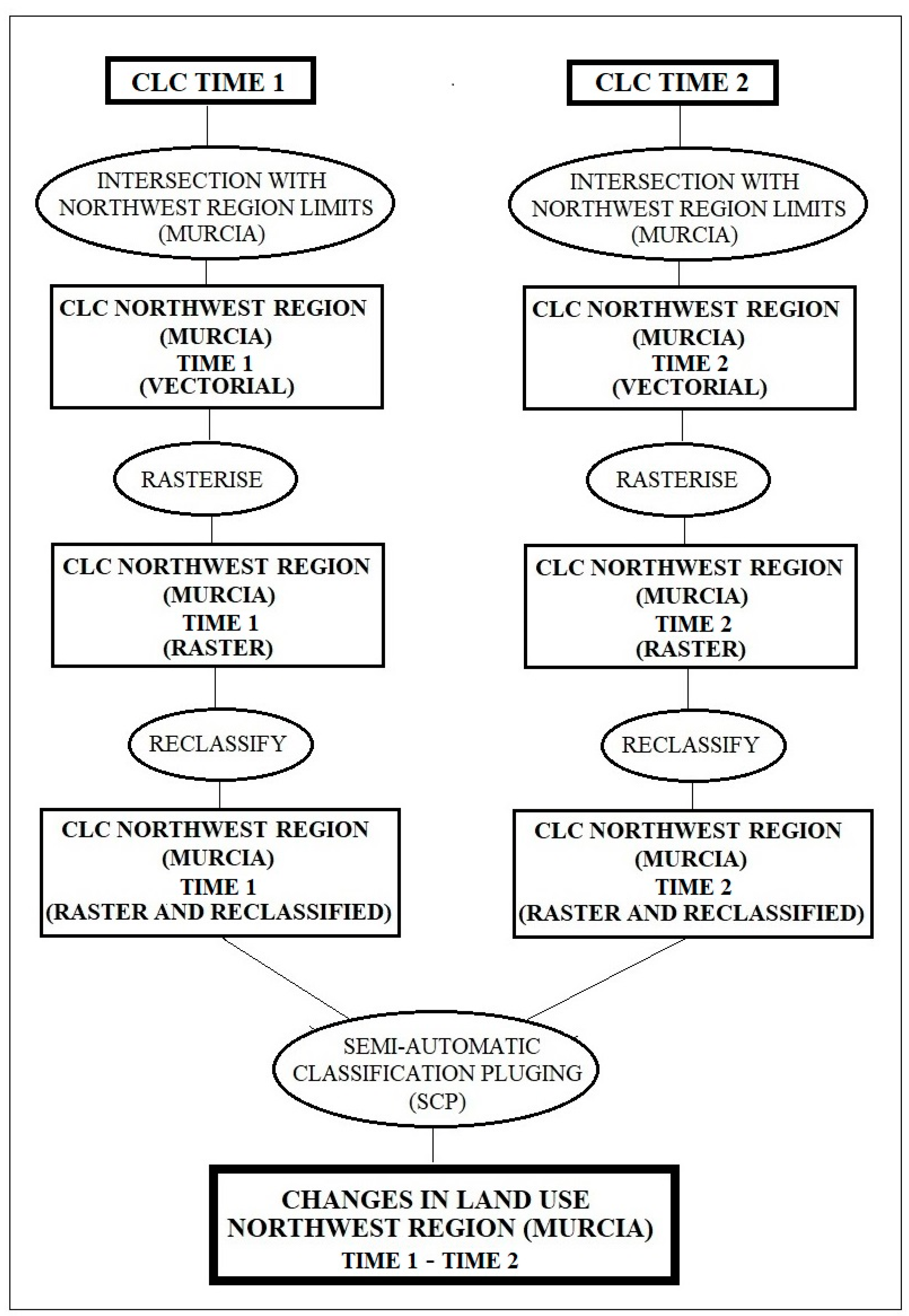
2. Materials and Methods
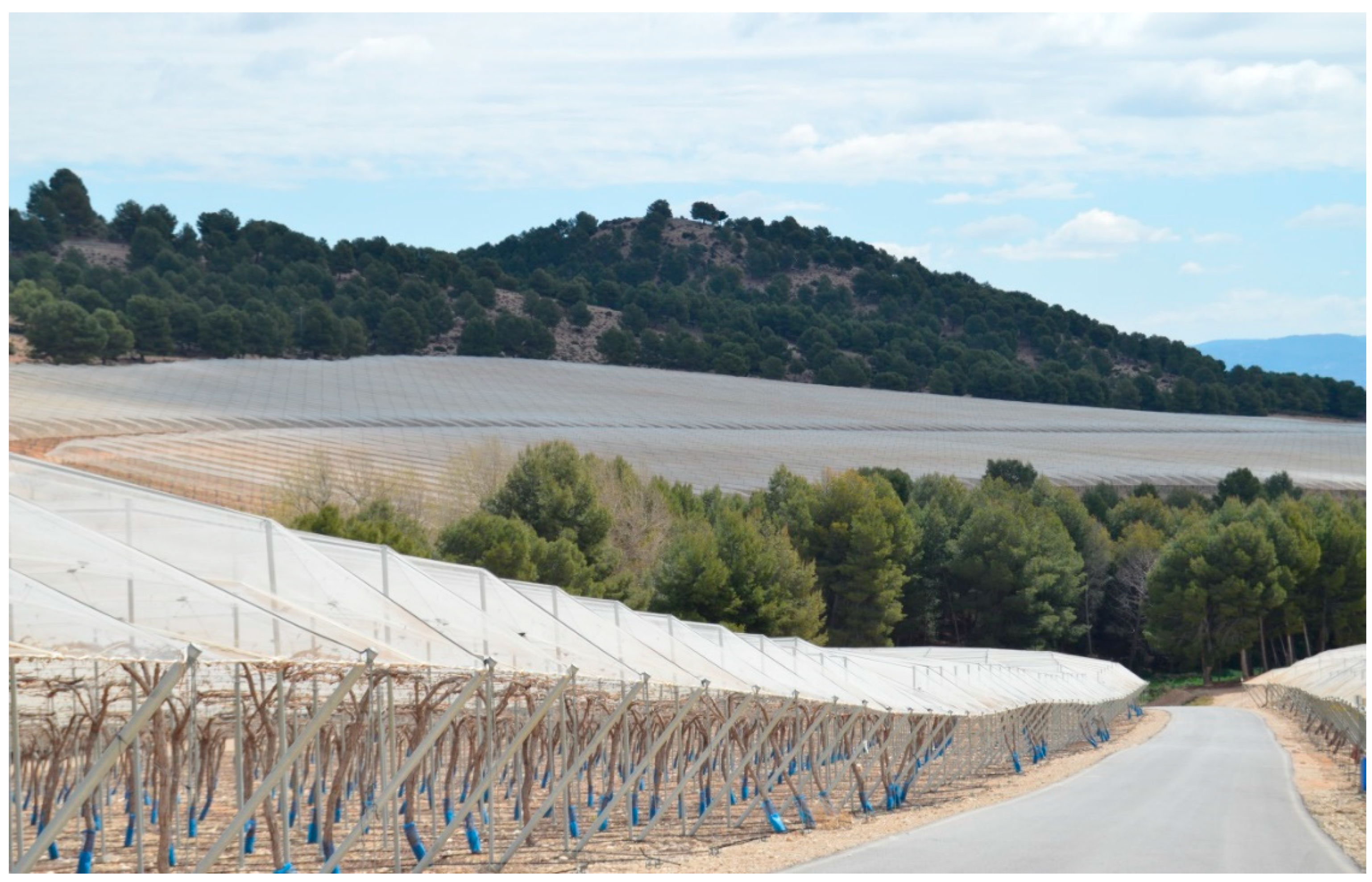
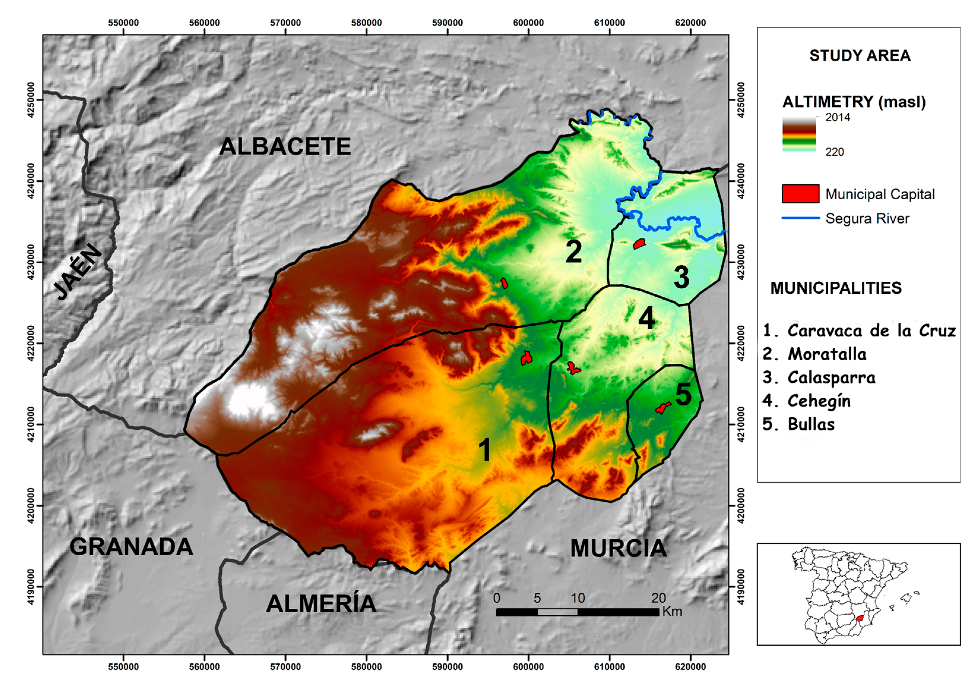
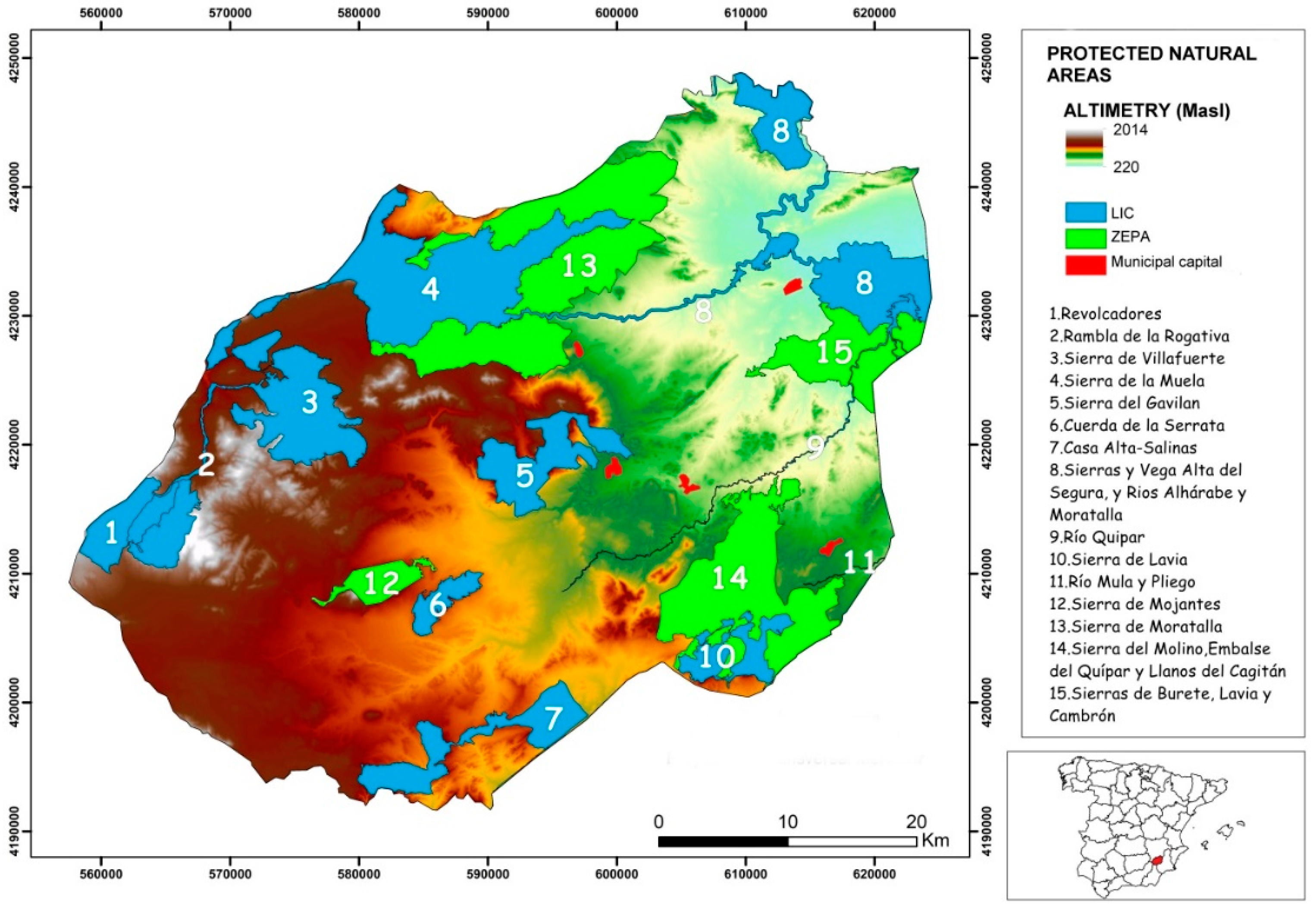
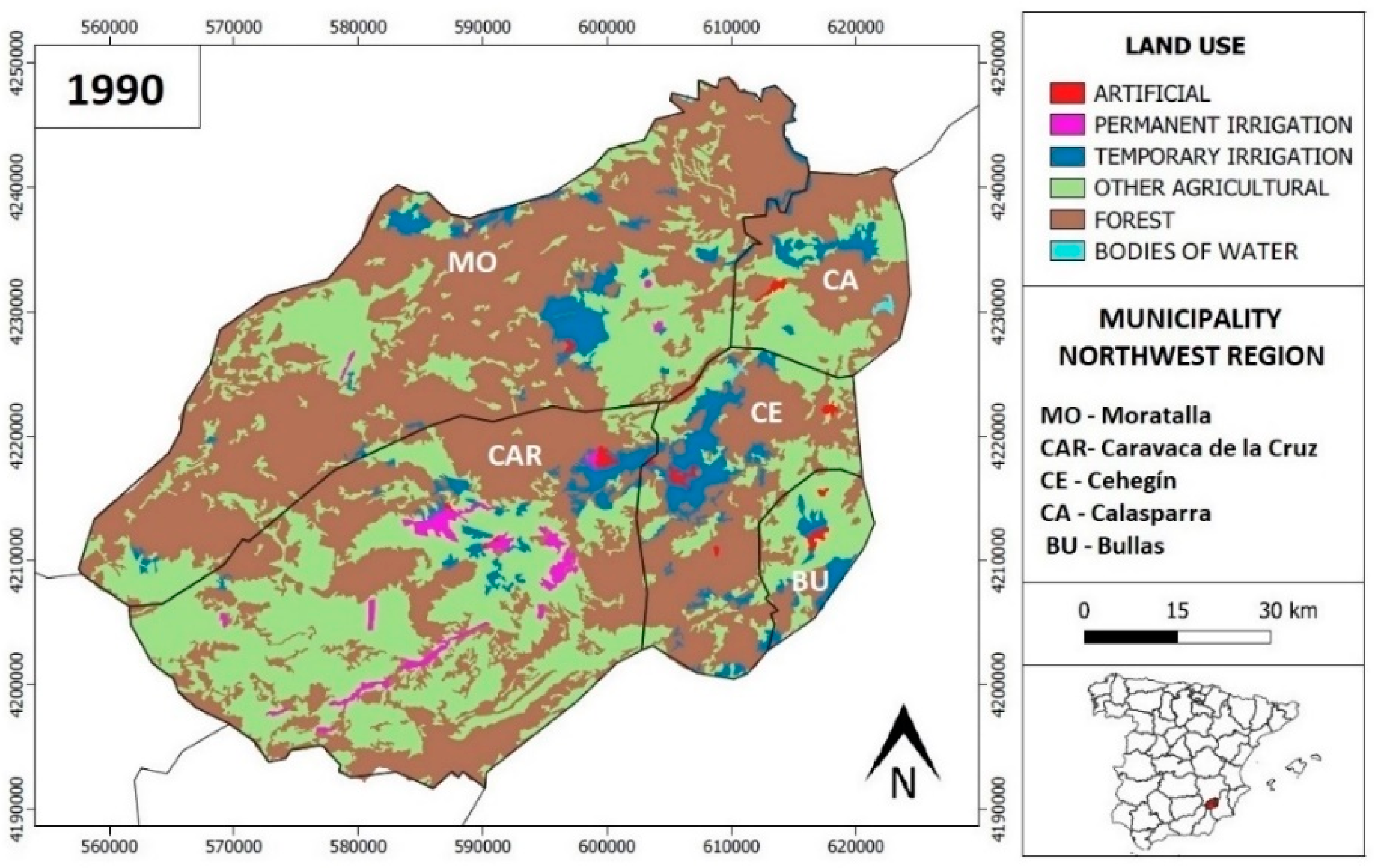
According to Stake [62], there are two main ways to approach an investigation: one oriented to measurements and the other to experience6, both of which enrich the understanding of the reality analysed. Furthermore, as claimed by Salkind [63], the analysis of data should provide a broad picture of the phenomenon that is interesting to explain, without forgetting that understanding the descriptive nature of an event is as important as understanding the phenomenon itself—for this reason it is not possible to evaluate or appreciate the progress that has been made without understanding the context in which such events took place.
The progress made in recent years by the GIS—geographical information system—together with the opening of geolocated databases, has motivated the development of projects that seek to investigate changes in coverage and land use [64]. The detail and reliability achieved by spatial data, generated through satellite images, make it possible to carry out analyses of territorial and landscape dynamics with a very high degree of precision [65]. The availability of temporary series offered by the main territorial data sources facilitates the comparison of changes in the coverage and land uses experienced in a specific territory [66].
Among the different sources that disseminate geo-referenced spatial information, this study draws on territorial data provided by the European Environment Agency (EEA), in its Corine Land Cover (CLC) project. The reasons for the use of this remote information source are the homogenisation of coverage and the breadth and updating of the space–time series provided.
To analyse the different territorial changes, the project compares the evolution of land cover between different time periods (1990–2000–2012–2018). For this, the spatial information (in vector format) obtained from the CLC project was processed using GIS software (ArcGIS 10.3 and Qgis 3.6.2) (Figure 1). The initial step consisted of filtering the data from the CLC project and thus adapting it to the analysed study area. Once the spatial information corresponding to the study area was obtained, the representation of the data was transformed, going from a vector format (polygons that represent the coverage and land use) to a raster (a board of pixels that acquire a value depending on the coverage or land use that they symbolize). When this geoprocess was executed, the spatial delimitation the study area (in this case the northwest Region of Murcia) was available, fragmented into a mesh of regular cells of a pre-established size (10 × 10 m, 100 m2).
Later, the 25 classes of land uses initially existing in CLC were grouped into six types in the reclassification process: (1) Artificial, (2) Permanent irrigation, (3) Temporary irrigation, (4) Other agricultural uses, (5) Forest and (6) Bodies of Water. In order to carry out a deep analysis, agricultural uses were divided into three different categories. Category 2 includes permanently irrigated land. Category 3 (temporary irrigation) includes vineyards, fruit trees, rice fields and olive groves. Finally, Category 4 (other agricultural products) covers rainfed agricultural land, grassland and heterogeneous agricultural areas.
Finally, the evolution of the data (rasterized and reclassified) between the different time periods studied was obtained by contrasting them with the Semi-Automatic Classification Plugin (SCP) tool [67].
The information obtained from this process was expressed through the use of cross-tabulation matrices or transition matrices, a method proposed by Pontius et al. [68] to analyse maps of land use among two temporary periods in order to detect the most significant changes between the different land uses (Table 1).
The matrix represents the ground cover during the first period (Time 1) in rows, and those of the second period (Time 2) in columns. Pij represents the proportion of land use that changes from category i to category j. Pjj, on the diagonal, indicates the persistence ratio of category j, while the other cells indicate a transition from category i to a different category j. Furthermore, the losses are expressed as the difference of category i between Time 1 and Time 2. The gains are expressed as the difference of category j between Time 1 and Time 2.
The described methodology is configured as a powerful instrument of analysis that allows us to understand the spatial transformation experienced between two specific moments in time, and to undertake effective territorial planning policies.
The proposed methodology would help in any other area with similar problems to effectively understand the changes in land use that have occurred, and thus try to make the best possible decisions to achieve a most sustainable development.

3. Study Area

The study area has an area of 2378 km2. A series of geographic circumstances are decisive in explaining the outstanding diversity of the territorial landscape mosaic in the northwest Region of Murcia, its singularities and its ecological coherence. Undoubtedly, water is, along with large landforms (Figure 2), a defining and identifying element of the landscapes of the territory being studied. Forest landscapes show a greater stability. This is the result of special biogeographic conditions, defined by the location of the territory in an area of climatic transition between the Mediterranean and continental environments, which is combined with great complexity and orographic and lithological diversity. It is pertinent to highlight the ecological value of these forest areas, with vegetation adapted to the particular conditions of the territory. These mountainous lands constitute a fundamental part of the local identity and are highly valued by the resident population.
The area studied presents a very abrupt, steep relief in the area of the headwaters of the main rivers, with the presence of mountain systems that, in the extreme north and northwest, exceed 1500 m in altitude. The average altitude is high, standing at 1050 m above sea level.
The rivers and streams or existing torrents are not only channels of an important natural resource such as water, but they also constitute rich ecosystems with very diverse values: ecological, landscape, cultural, etc. These are mostly sporadic water courses, which bridge steep slopes and transport water after heavy rains. These river landscapes are shaped as intermountain corridors that facilitate the connection between different mountain areas or between these areas and the nearby plains. While maintaining an outstanding natural character, they host a greater number of interventions of anthropic origin.
It is necessary to highlight a recent process, but of clear importance to the landscape: the pressure of agricultural use on land occupied by natural vegetation. The ploughing of nonagricultural lands for plant crops constitutes a transformation that breaks with the dynamics of reduction in the ploughed area that has been seen in recent decades, due to the low profitability of rainfed crops (Figure 3). In fact, in areas not affected by the development of intensive irrigated agriculture, the most frequent have been processes of abandonment of the less productive terraces that have come to be colonised by natural plant formations.
The study area has a large number of springs and seeps of water. The springs constitute fundamental enclaves in the configuration of the landscapes. They reveal the natural drainage points of the aquifers, frequently support wetlands and aquatic ecosystems, and have historically linked numerous settlements that have emerged under their protection, providing basic services such as a water supply to the population. In general, the quality of its water is excellent and the overexploitation of its aquifers has been scarce until a few years ago, unlike what happened with the coastal and pre-coastal hydrogeological units in the Region of Murcia, which are highly overexploited. This low overexploitation is due to the fact that the pressure and intensity of agricultural activities has been less than in other regional areas. Nevertheless, in recent years a clear increase in the irrigated area has been taking place (Figure 4 and Figure 5), which causes a significant negative impact on the aquifers of this territory [69]. The protected natural lands (Site of Community Importance (SCI) and Special Protection Area for wild birds (SPA) (Figure 6) are of great importance in this territory, occupying a total of 691.0 km2 (29.0% of the territory).

4. Results

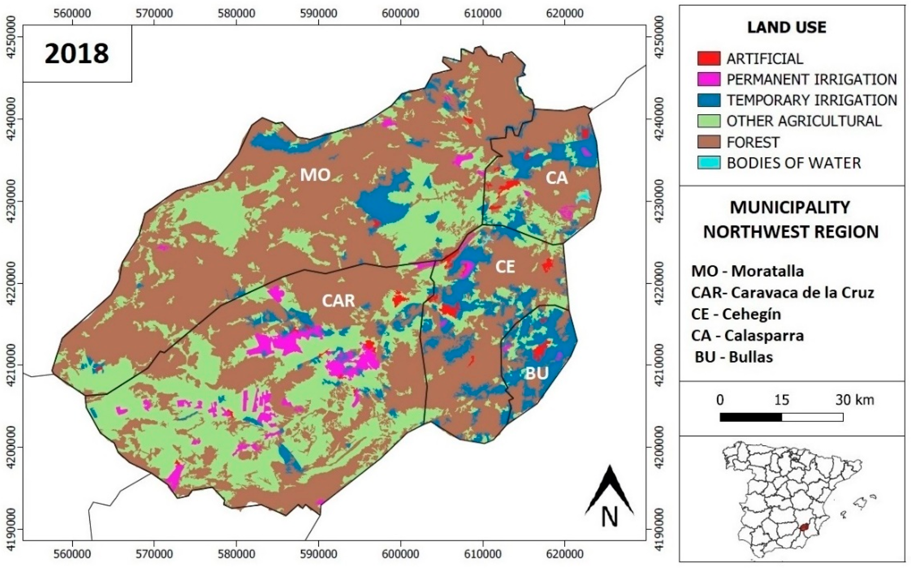
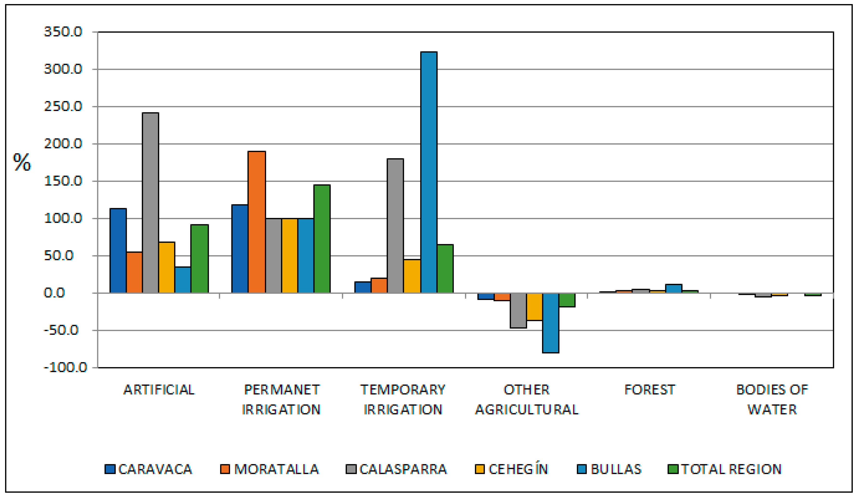
4.1. Recent Evolution of the Coverage and Land Use in the Northwest of the Region of Murcia (1990–2018)

Regarding land use, three main types can be distinguished: natural, agricultural and urban-industrial. The main use is natural (forest), representing around 56.7% of the total area. It is made up of wooded, shrubby and subshrub formations. Agricultural use constitutes around 28.5% of the territory and can be found in the valley areas and in the alluvial fans and glacis of quaternary origin. The proportion of land dedicated to rainfed and irrigated crops is similar, although in recent years, as already mentioned, there has been a notable increase in irrigated areas. Currently, fruit trees (cherry, peach and apricot trees) are the main irrigated crop, as cereals and almonds are on rainfed land. Urban and industrial areas only represent 5.0%.
Firstly, the temporal evolution of land use distribution (Table 2) is presented with the aim of evaluating the transformations that have taken place and in which period they have been most intense. Between 1990 and 2000, the changes are insignificant. The most important changes took place between 2000 and 2012, coinciding with a decade of great economic expansion until the economic crisis started in 2008. During this time period, the most notable increases are shown in the categories of permanent and temporary irrigation, with the increase in the permanent irrigation area that doubles its surface being especially significant. One of the causes of this spectacular growth lies in the transfer of agricultural enterprises from the pre-coastal valleys to the interior lands of the Region of Murcia, taking advantage of the greater availability of water resources in this territory. Between 2012 and 2018, there is a transfer of surface area from permanent to temporary irrigation, which in turn is occupied by fruit trees.
The effects generated by the urban expansion of the pre-existing settlements, the projection of new residential and industrial complexes and, above all, the proliferation of large areas of intensive cultivation, has led to a soil mutation that must be analysed. It is important to highlight that the artificial surface is very small in this territory, in comparison with the nearby municipalities of the Mediterranean coast. In 1990, the northwest of Murcia had just over 10.0 km2 of artificial soil. Three quarters of this small area was concentrated in the municipalities of Cehegín and Caravaca de la Cruz (Table 3).
The meager spatial dimension of the coverage made up of urban fabric contrasts with the development of agricultural and forest use. This discrepancy shows the marked rural character of the analysed land. In 1990 more than half of the regional land was occupied by forest mass, reaching 67.5% in the Moratalla municipality, 58.2% in Cehegín, and 52.5% in Calasparra (Figure 7).
In 1990, cultivated land occupied 44.4% (1056.5 km2) of the total area. Among the different agricultural typologies, rainfed agriculture stands out (included in the category “other agriculture”), with a total of 886.8 km2. This type of cultivation represents 83.9% of all agricultural land and is most clearly developed in Caravaca de la Cruz, a municipality in which, at the end of the last century, occupied half of the local area (429.5 km2).
The mutation of techniques and contributions in plantations meant that, between 1990 and 2018, the permanently irrigated cultivation area went from 24.4 to 59.6 km2, and the temporary irrigated area from 145.3 to 237.9 km2. This development occurred thanks to the occupation of land traditionally cultivated by rainfed plantations. Most of the rainfed land losses are located in the municipality of Bullas, which went from having almost fifty square kilometres occupied by this type of agriculture in 1990, to less than 10.0 km2 in 2018 (a decrease of almost 80.0%) (Table 4).
On the other hand, temporary irrigation shows the greatest increase. Within this category, fruit trees represented the majority of the surface, with a total of 211.3 km2 in 2018. These are distributed homogeneously in all the municipalities, although they have a greater presence in Bullas, Cehegín and Moratalla. Yet, rice fields make up an area of 8.1 km2, most of which is located in the municipality of Calasparra, which has one of the three protected designations of origin (PDO) for rice fields in Spain—the PDO Calasparra rice. Vineyards occupy an area of 9.3 km2, 84.9% of which are located in the municipalities of Bullas and Cehegín, and which are part of the PDO Bullas. Finally, olive groves have an area of 9.1 km2, with the municipality of Moratalla encompassing a larger area. Between the years 1950 and 1990, the area occupied by olive groves in the Region of Murcia was reduced considerably (−25.0%), but this decline had its lowest incidence in the municipality of Moratalla [70].
Bullas is the municipality with the greatest development of temporarily irrigated plantations, as it represents an increase of 321.4%. Calasparra provides an increase in the temporarily irrigated area of 180.3%, thanks to the presence of the Río Segura river and its traditional rice production (Figure 8). Cehegín also shows a notable increase in the temporary irrigated area (44.1%). Moratalla and Caravaca hardly increase their temporary irrigated area. The climatic and orographic conditions play a fundamental role in this distribution, since due to the higher average altitude, the municipalities of Moratalla and Caravaca are more vulnerable to the risk of frost.
Artificial land doubled its surface, forming the typology that experienced the second greatest increase in relative terms (91.3%). This fact explain, to a large extent, the development in the region of the marble limestone industry, with a dual purpose: extraction, and cutting and preparing the pieces for use by the construction sector [71].
The municipalities most affected by urban development are Calasparra (241.0%) and Caravaca de la Cruz (112.1%). However, one should not disregard the high burden of the artificial surface reached in Cehegín (6.5 km2). Nevertheless, the Spanish real estate boom, between 1997 and 2007, had little impact in this territory, unlike what happened in the municipalities of the Mediterranean coast and the areas adjacent to the most dynamic cities (Murcia, Cartagena or Lorca).
The area occupied by forest cover and bodies of water has hardly changed. Reforestation, especially in Calasparra and Bullas, has contributed to a slight increase of 2.3% in the surface of this category. For its part, the aforementioned increase in exploitation to which water resources are subjected, together with long periods of low water and the moment in which satellite images are taken, by which spatial data are estimated, determines the slight decrease in the surface occupied by bodies of water (Figure 9).

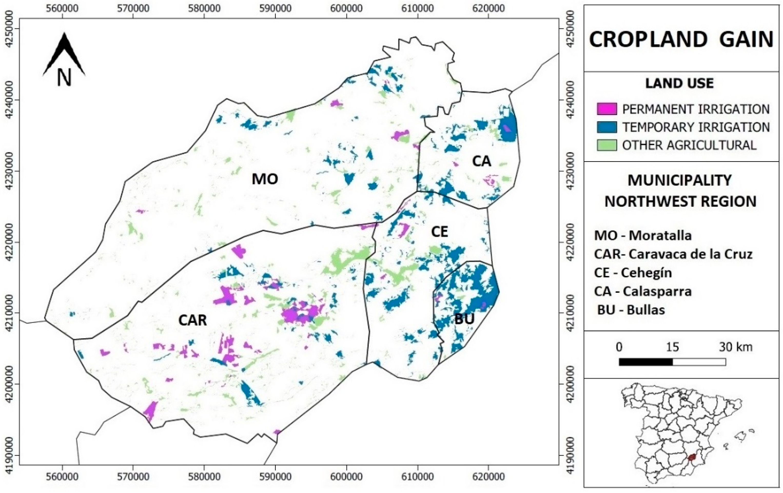
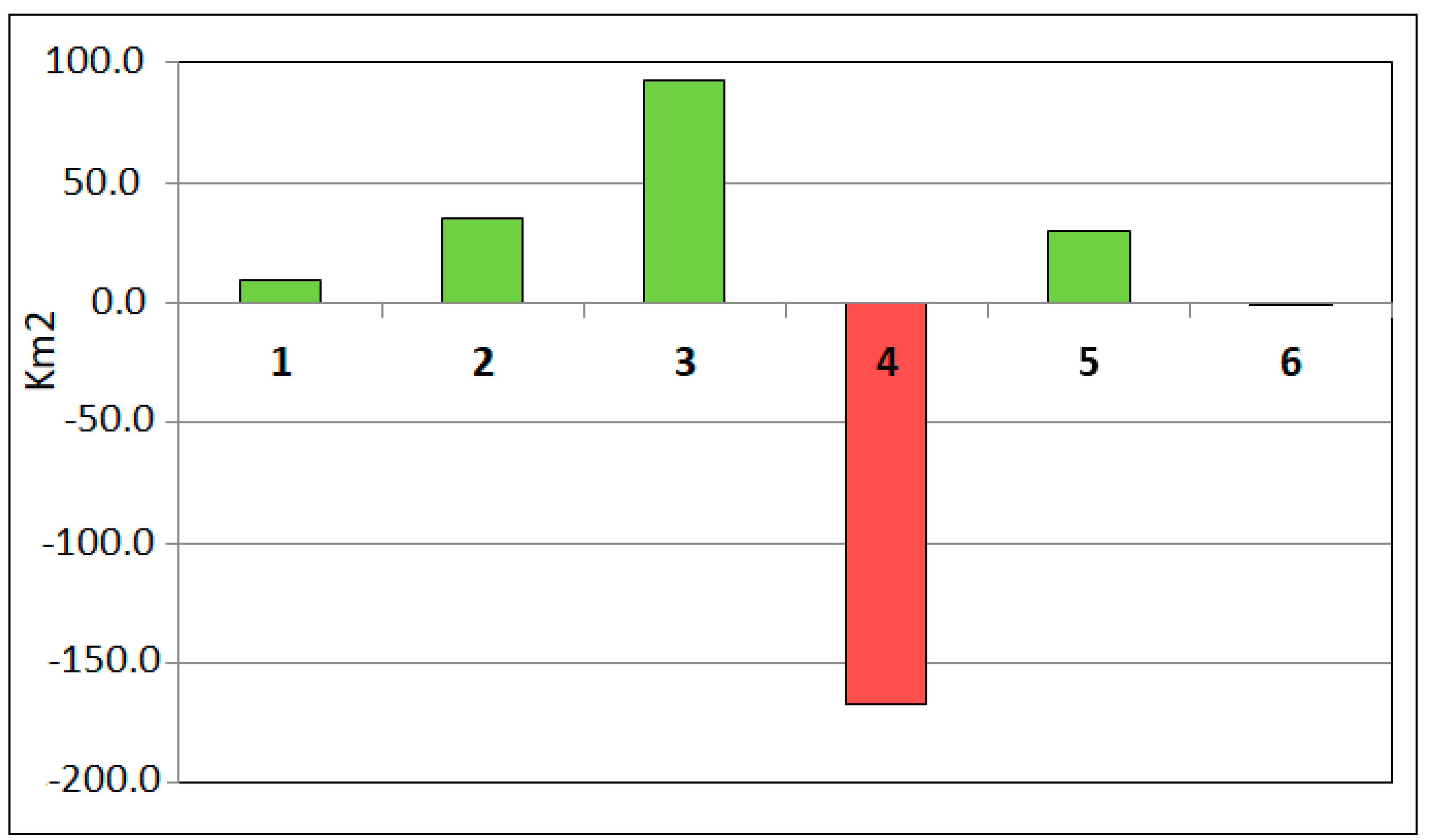
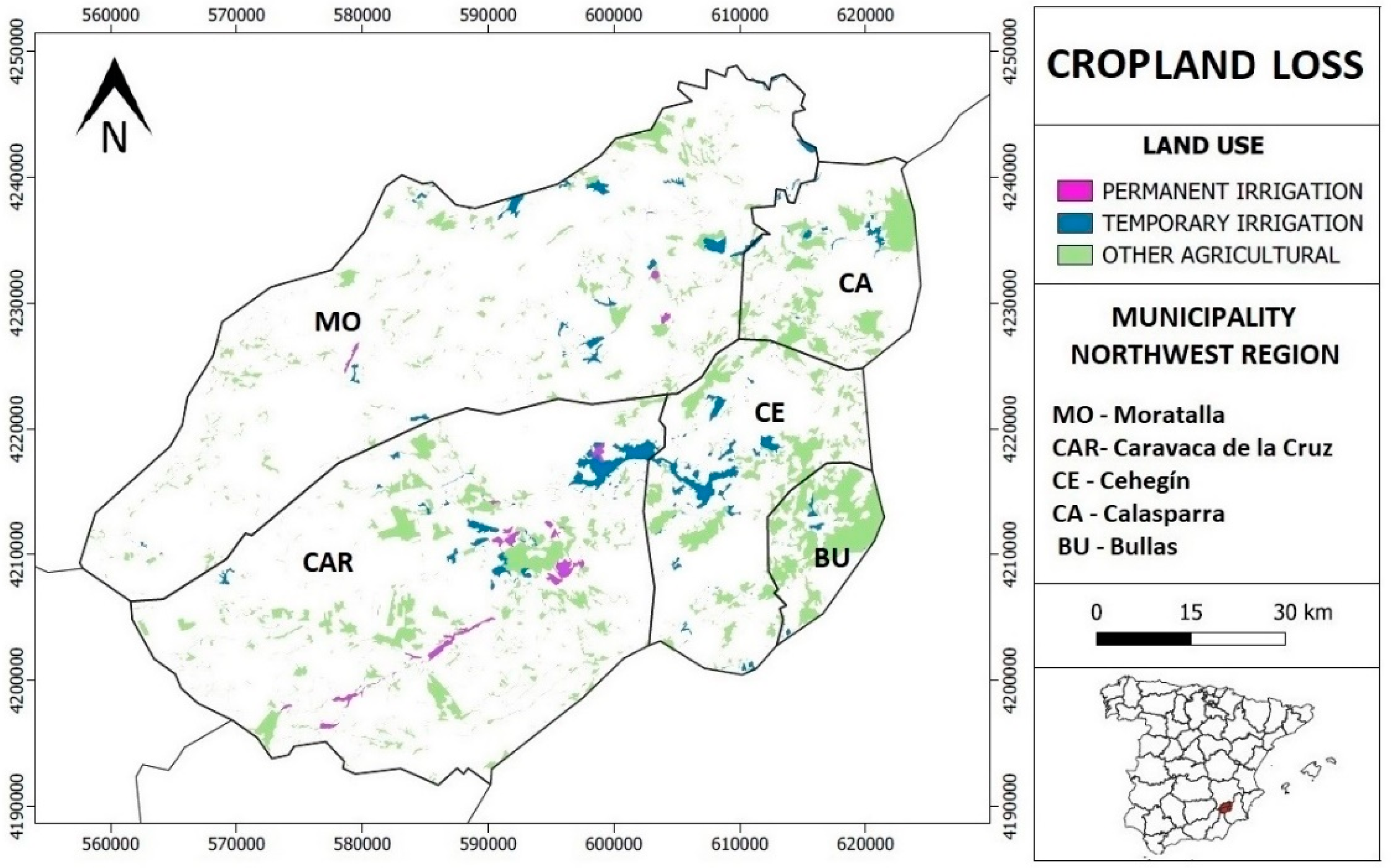
4.2. Transitions and Spatial Dynamics between Coverage and Land Use

In this section we contrast the changes that have occurred through a comparison by time pairs. Thanks to the analysis of the cross-tabulation matrix (Table 5), the spatial transitions that have occurred between the different territorial uses are examined: artificial (1), permanently irrigated agriculture (2), temporarily irrigated agriculture (3), other agricultural uses (4), forestry (5) and bodies of water (6). The figures reveal the total area gained and lost by each coverage, obtaining values that are represented cartographically.
Over the period which was analysed, the urbanised area which occupied 11.6 km2 only lost 2.0 km2. In total, 50.9% of the captured artificial surface came from rainfed crops; 30.2% was forest mass; the remaining 18.9% was irrigated agricultural land (regardless of the frequency of water contributions).
Most of the spatial area acquired by forest cover (90.8%) belonged to rainfed plantations (100.4 km2), both constituting the only categories that have yielded land in favour of the slight expansion of bodies of water (0.3 km2). This water coverage continued to be stable, persisting with 88.0% (2.2 km2) of the surface declared in the first year examined (1990).
The entire cultivated area has increased by 295.0 km2, and more than half is divided between temporarily irrigated land (142.5 km2) and other crops (105.6 km2). As previously mentioned, it is worth noting the incredible development of crops with temporary irrigation in the municipality of Bullas (322.1%), and permanently irrigated crops in Caravaca de la Cruz (117.5%). Within the category of temporary irrigation, fruit trees represent the majority of this increase, since between 1990 and 2018 there has been an increase of 91.9 km2. Calasparra (+358.2%) and Bullas (+314.7%) are the municipalities that show the greatest change. Regarding permanent irrigation, although there has been an increase in all municipalities, it should be noted that the municipality of Caravaca has the majority of this expansion; in this district or municipality there has been a spectacular growth in the surface of horticultural crops (lettuce, broccoli, chard, etc.), with very high water needs and the consequent overexploitation of aquifers.
The meteorological conditions marked by the altitude at which the western area of Moratalla is located, together with the large amount of surface that has some type of Site of Community Importance, SCI, and Special Area of Conservation, SAC, to determine the low presence of intensive crops, an aspect for which the use of traditional rainfed agriculture still prevails and there has been no significant transformations (Figure 10). In fact, the municipality of Moratalla, despite being the largest municipality, is the one that has lost the least area of rainfed crops. In this municipality, rural landscapes are a fundamental tourist resource [72]. In its territorial area, the cultivation of aromatic plants, such as lavendin or lavender, has boomed in recent years. These crops are part of the productive reconversion towards agroecology that is emerging in the northwest Region, which is constituted as a viable alternative to sustainable management in the use of water for irrigation, in a context of a semiarid climate [73].
The notable expansion achieved by plantations with water needs derives from the change in the land exploitation system, with the transformation of 124.6 km2 from rainfed land to temporary irrigation and 41.6 km2 from rainfed land to permanent irrigated crop. The sum of these exchanges between agricultural areas causes the rainfed cultivation area to acquire the greatest spatial decline observed (272.6 km2). This decline is especially noticeable to the south and east of the region (Figure 11).
The corresponding graphic represents the total balance of profit and loss and reveals the true development of each one of the analysed categories (Figure 12). In this sense, we can see the huge decline experienced by the category labelled as the rest of agriculture (167.0 km2). This collapse contrasts with the important gains made by the irrigation crop, especially when staggered (92.6 km2).
Finally, it is worth noting the significant increase in the area occupied by forest mass (29.7 km2), the contained evolution of the artificial area (9.6 km2) and the negligible spatial decline of the bodies of water (0.1 km2).

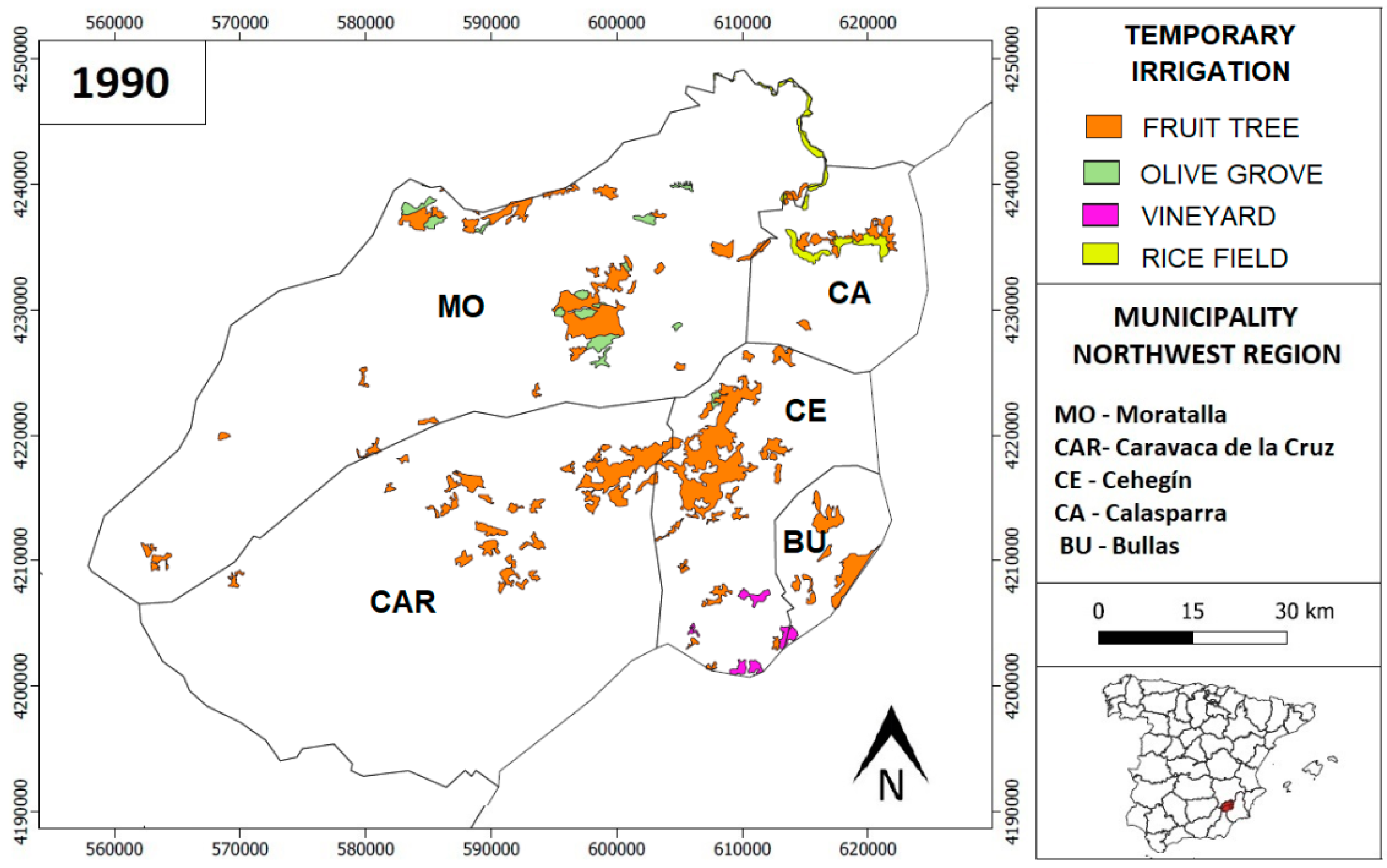
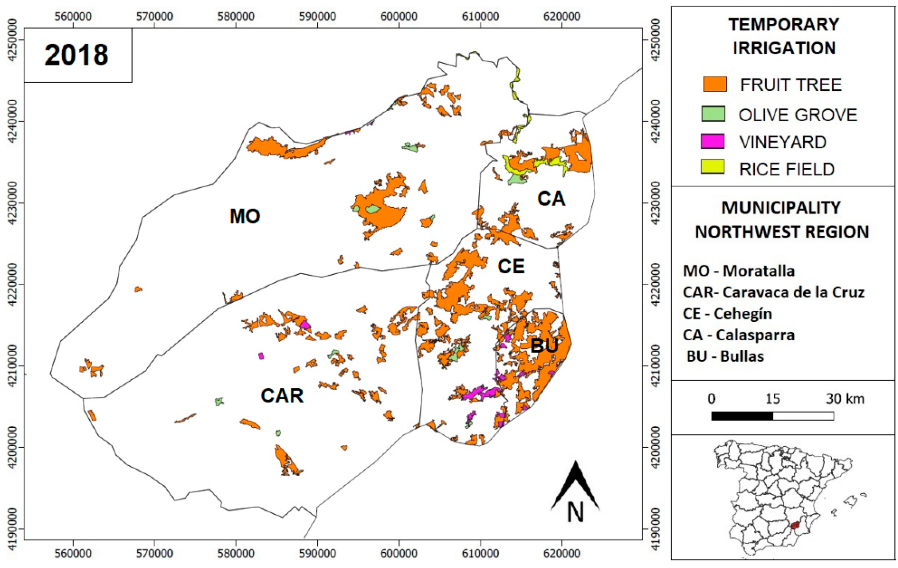
4.3. Evolution of Temporary Irrigation Crops

Among the three agricultural categories studied, it is interesting to analyse the evolution experienced, during the last three decades, by the different temporary irrigation crops because it is the category that has experienced the most notable change. In spite of conforming an agricultural typology that lacks the need to maintain a permanent water supply, the water demands requested for the correct development of the production of each of the crops in this category are different. In this sense, the amount of water required to plant fruit trees, rice or vineyards differs from that required for olive trees, which is the type of crop that requires the least amount of water.
The fruit tree is the most widespread type of temporarily irrigated crop in all municipalities. In 2018, this tree category occupies about 88.8% of all the agricultural area temporarily irrigated (211.3 km2). The development of this crop makes up, throughout the observed time series, practically all of the increase in ephemeral irrigated land (Table 6). Fruit trees are the temporarily irrigated crop that consume the most water and therefore their notable increase in the last three decades leads to an increase in the overexploitation of aquifers.
A third of the fruit trees planted in the study area at the beginning of the last decade of the last century are located in Cehegín. Although the representation exercised by this crop in this municipality loses weight over the years, the town with the largest area of fruit of the treated area (55.9 km2) was found in 2018. Among the different municipalities where this crop is present, Bullas has experienced the most remarkable spatial expansion, with an increase of more than 33.9 km2 (320.6%) between 1990 and 2018. One of the facts that contrasts the agricultural data of the two periods taken is the specialization that registers, at the beginning of the series, some municipalities in the production of one or two concrete cultures, and the multiproductive diverisfication that is appraised at the present time. Thus, practically all the temporarily irrigated crops in Caravaca and Bullas (1990) corresponds to fruit trees (Figure 13).
Of the crops studied, rice is the one with the greatest need for water, so its territorial opening is very limited and is also limited to the plains of the Segura river only. In this context, rice practically occupies the same area. Thus, the availability and presence of the continuous course of water of the Segura river means that Calasparra and Moratalla constitute the only municipalities with this type of production. However, the production dynamics experienced during the last years by both localities demonstrates the setback that the culture of this food has undergone in Moratalla, and the development acquired in the regional rice municipality par excellence (Calasparra). The impulse noticed in Calasparra has not been sufficient, and the regional surface planted of rice has decreased more than 21.0% in the last decades. Something similar happened with the olive trees, a product that was initially taken care of almost exclusively in Moratalla and, in spite of expanding to the rest of localities (except Bullas), its presence decreased by 15.1% (Figure 14).
Finally, the crop that occupies the smallest area in 1990 (vineyard) almost doubles its extension in 2018, spreading to all municipalities except Calasparra. The present production of vine has been diversified, with varieties oriented as much to the consumption of wine as of table grape. Regarding the fruit trees, the Cehegín host in 1990 had 88.0% of its soil covered by vineyards. The area occupied by this crop in this town increased to over 5.2 km2 (2018). In spite of this, the representation that supposes the surface of this culture in Cehegín decreased until being placed slightly above 50.0% of the total sowed space.

5. Discussion

The spatial dimension of sustainability is generating increasing interest from both scientific and social perspectives. The northwest of the region has experienced, over the last three decades, an unprecedented process of territorial transformation [74]. The abundant underground water resources and the large extension of undeveloped rural land (in terms of economic profitability) has served as an element of attraction for a large number of agricultural and real estate companies [75]. The presence of companies dedicated to various sectors has generated fierce competition for the control and exploitation of a land used, historically, in the traditional cultivation of orchards and rainfed land [49]. The strength of intensive agriculture has displaced the traditional use of land.
The leasing of land by large agro-export companies encouraged the use of agricultural land, with the insatiable water exploitation of the area. This fact caused a change of scenery, with the indiscriminate spread of crops irrigated permanently and temporarily.
According to [76] the imbalance between the resources and the demand has been caused by the expansion of irrigated areas, the emergence of illegal new irrigated lands and pumping wells, the increase in energy cost and the bad management of water use rights by the public water administration. In addition, climate change and frequent droughts in this semiarid region aggravate the situation. As a consequence, many aquifers are being overexploited [77]. In this sense, the fulfilment of the “good ecological status” objectives set by the Water Framework Directive, with a deadline of 2027, will be a difficult task for water managers.
The increase in new irrigated land is not exclusive to inland areas near the coast [78,79]. Additionally, in practically all cases, farmers, experts and managers are trying to adopt measures to reduce environmental and social impacts, minimizing the loss of agricultural productivity, of course.
The general objective in the analysed cases is to create an integrated and integral management system of the aquifers. Integral management means that both supply and demand management are considered, including the socioeconomic and environmental perspectives. The concept of integrated management implies that the process must involve the majority of economic and social agents affected [80,81,82].
In the Region of Murcia, [83] developed a new irrigated lands dynamic model, that includes five sectors: Irrigated Lands, Profitability, Available Space, Water Resources and Pollution. The dynamic model simulates the environmental effects regarding water consumption with reference to aquifer levels, natural outflows through springs, piezometric levels and aquifer water salinity. The exploration of scenarios shows that current policies based on the increase in water resources do not eliminate the water deficit problem because the feedback loops of the system lead to a further increase in irrigated land and continuation of the water deficit. In the Southeast of Spain, the increase in irrigated areas does not seem to have an end.
Returning to our concrete case study, mountainous rural communities have traditionally managed their land extensively, resulting in land uses that provide important ecosystem services for both rural and urban areas. According to [84], land use intensification results in economic development but is not enough to prevent population loss, and has a negative impact on both the water supply and on aesthetic services (landscape). The authors conclude that more proactive management policies are needed to mitigate a loss in ecosystem services. They propose a simulation model that may facilitate the choice of land use planning policies, contributing therefore to a more integrative and sustainable management of rural communities.

6. Conclusions

Obviously, the areas occupied by new intensive irrigation on old rainfed farmland in the northwest Region of Murcia have increased in the last 30 years. In the Region of Murcia, there is a traditional ambition (a desire which coincides with the title of this article) for the continuous increase in irrigated areas. However, the success of the new installed fruit and vegetable model is not without contradictions and tensions that are expressed as negative environmental- and social-outsourced needs. In its industrial development, it tends to move towards the reduction in natural biodiversity, dislodging and eliminating forms of life not directly linked to productivity. Its expansionary trend have also led to an unlimited use of basic natural resources such as soil and water, generating social, environmental and political problems. The continuous growth of the water needs of the agro-industrial model, despite improvements in the efficiency of water use, is generating temporary deficits not noticed by traditional farmers until a few years ago.
The development of management tools that can harmonize the exploitation of water resources with the sustainability of the reserves is the objective that the administration and agricultural entrepreneurs must agree on.
Given this conflictive situation, it is necessary to propose strategies for the progressive reduction in these new irrigated areas with little social and environmental commitment. In this sense, we propose a series of criteria to identify where a strategy in irrigation reduction is necessary:
  • Water limitation criteria: we propose applying indicators such as the Water Exploitation Index (WEI)7 and others.
  • Profitability criteria: we suggest evaluating the profitability of irrigation after incorporating environmental costs.
  • Environmental sustainability criteria: we recommend continuously analysing indicators on the quality status of water bodies, applying the Water Framework Directive. Likewise, we propose constantly examining indicators of circulating flows and even indicators of other impacts related to the energy balance or to the analysis of the life cycle of products.
  • Territorial sustainability criteria: we propose identifying irrigation systems located outside their areas of vocation or natural aptitude and to recognise the need to preserve crops with high cultural and environmental values (particularly traditional irrigation systems with a high diversity and mosaic crops). Being located in or not in the territory of the owners of agricultural companies may constitute another factor for the assessment of this territorial dimension.
  • The social viability criteria are a more open and complex question. Obviously, it is not easy to precisely define what is considered irrigation for social interest. Therefore, it is perhaps more useful to replace this concept, which may be ambiguous, with more specific operational criteria, such as the impact on local employment, the distribution of costs and benefits, or the identification of irrigated areas with high social conflict. In this sense, irrigation with high environmental costs and a low social profitability (large landowners, little distributed wealth, low-quality temporary employment) would be a candidate for a reduction in the irrigated area.
Finally, we believe that there is an urgent need to update the land registry of agricultural areas in order to carry out a fiscal adjustment of the lands transformed from rainfed land to irrigated and new farms that have emerged in recent years.

Author Contributions

Conceptualization, R.G.-M. and C.E.-M.; methodology, R.G.-M., R.G.-G., V.R.-Á.; formal analysis, R.G.-M., C.E.-M., R.G.-G. and V.R.-Á.; investigation, R.G.-M., C.E.-M., R.G.-G. and V.R.-Á.; data curation, R.G.-M., R.G.-G., V.R.-Á.; writing—original draft preparation, R.G.-M., C.E.-M., R.G.-G. and V.R.-Á.; writing—review and editing, R.G.-M., C.E.-M., R.G.-G. and V.R.-Á.; supervision, R.G.-M. All authors have read and agreed to the published version of the manuscript.

Funding

This research received no external funding.

Acknowledgments

Authors want to thank anonymous reviewers for their suggestions, which have helped to significantly improve the manuscript.

Conflicts of Interest

The authors declare no conflict of interest.

References

  1. Arahuetes, A.; Hernández, M.; Rico, A.M. Adaptation strategies of the hydrosocial cycles in the Mediterranean region. Water 2018, 10, 790. [Google Scholar] [CrossRef] [Green Version]
  2. Ricart, S.; Rico, A.M. Assessing technical and social driving factors of water reuse in agriculture: A review on risks, regulation and the yuck factor. Agric. Water Manag. 2019, 217, 426–439. [Google Scholar] [CrossRef]
  3. Rodríguez, R.; Garrido, A.; Llamas, M.R.; Varela, C. La huella hidrológica de la agricultura española. Ing. Agua 2009, 16, 27–40. [Google Scholar] [CrossRef] [Green Version]
  4. WWAP. The United Nations World Water Development Report 2015: Water for a Sustainable World; UNESCO: Paris, France, 2015; ISBN 978-92-3-100071-3. [Google Scholar]
  5. Caparrós-Martínez, J.L.; Rueda-Lópe, N.; Milán-García, J.; de Pablo Valenciano, J. Public policies for sustainability and water security: The case of Almeria (Spain). Glob. Ecol. Conserv. 2020, 23, 1–17. [Google Scholar] [CrossRef]
  6. Morales, A. Aspectos Geográficos de la Horticultura de ciclo Manipulado en España; Secretariado de Publicaciones-Universidad de Alicante: Alicante, Spain, 2007; ISBN 978-84-7908-354-0. [Google Scholar]
  7. Morales, A. Agua y territorio en la Región de Murcia; Fundación Centro de Estudios Históricos e Investigaciones Locales Región de Murcia: Murcia, Spain, 2001; ISBN 84-921128-7-5. [Google Scholar]
  8. Calvo, F. Les paysages de l’horticulture de cycle forcé en Espagne. Enquêtes Rural. 2002, 8, 101–117. [Google Scholar]
  9. Morales, A. Escasez y rentabilidad del agua en el Sureste de España: Agricultura de vanguardia, huertas tradicionales, nuevos regadíos y medio ambiente en el valle del Segura. In Medio Ambiente y Crisis Rural; Fundación Duques de Soria-Universidad de Valladolid: Valladolid, Spain, 1996; pp. 131–157. ISBN 84-7762-657-X. [Google Scholar]
  10. Gil, A. Agua y agricultura: Transformaciones recientes, problemas medioambientales y socioeconómicos. Geographicalia 1997, 34, 67–108. [Google Scholar] [CrossRef] [Green Version]
  11. Geteches, H.D. Spain’s Ebro River Transfers: Test Case for Water Policy in the European Union. Water Resour. Dev. 2003, 19, 501–512. [Google Scholar] [CrossRef]
  12. Swyngedouw, E. Liquid Power: Contested Hydro-Modernities in Twentieth-First Century Spain; The MIT Press: Cambridge, MA, USA, 2015; ISBN 978026202903213. [Google Scholar]
  13. López, E. Agua para todos: A new regionalist hydraulic paradigm in Spain. Water Altern. 2009, 2, 370–394. [Google Scholar]
  14. López, E.; De Stefano, L. Between a rock and a hard place: Re-defining water security, decentralisation and the elusive “Water Pact” in Spain. In Federal Rivers. Managing Water in Multi-Layered Political Systems; Garrick, D.E., Ed.; Eduard Elgal: Northampton, UK, 2015; pp. 158–176. ISBN 1843393158. [Google Scholar]
  15. Saurí, D.; Del Moral, L. Recent developments in Spanish water policy. Alternatives and conflicts at the end of the hydraulic age. Geoforum 2001, 32, 351–362. [Google Scholar] [CrossRef]
  16. Rico, A.M. Plan Hidrológico Nacional y Programa A.G.U.A.: Repercusión en las Regiones de Murcia y Valencia. Investig. Geográficas 2010, 51, 235–267. [Google Scholar] [CrossRef] [Green Version]
  17. Swyngedouw, E. Into the sea: Desalination as hydro-social fix in Spain. Ann. Assoc. Am. Geogr. 2013, 103, 261–270. [Google Scholar] [CrossRef]
  18. Swyngedouw, E.; Williams, J. From Spain’s hydro-deadlock to the desalination fix. Water Int. 2016, 41, 54–73. [Google Scholar] [CrossRef]
  19. March, H.; Saurí, D.; Rico, A.M. The end of scarcity? Water desalination as the new cornucopia for Mediterranean Spain? J. Hydrol. 2014, 519, 2642–2651. [Google Scholar] [CrossRef] [Green Version]
  20. Mata, R. Nuevos regadíos y cambio territorial: El caso del levante de Almería. In Historia, Clima y Paisaje. Estudios geográficos En memoria del profesor Antonio López Gómez; Universidad de Valencia, Universidad Autónoma de Madrid y Universidad de Alicante: Valencia, Spain, 2005; pp. 513–528. ISBN 84-370-5864-3. [Google Scholar]
  21. Gómez, J.M.; Gil, E.; García, R. El Antes y Después de la Modernización De Regadíos. la Experiencia de Mula; Editum: Murcia, Spain, 2006; ISBN 978-84-8371-617-5. [Google Scholar]
  22. Gil, E.; Gómez, J.M. Los paisajes rurales del Campo de Cartagena- Mar Menor. Del riego itinerante a la factoría bajo cubierta. In Atlas de Los Paisajes Agrarios de España, Ministerio de Agricultura; Alimentación y Medio Ambiente: Madrid, Spain, 2013; pp. 543–552. [Google Scholar]
  23. Rodríguez, T. Sobreexplotación de acuíferos y desertificación en el Sureste español. In Aridez, Salinización y agricultura en el Sureste Ibérico; Gil, A., Morales, A., Torres, F.J., Eds.; Fundación Ramón Areces-Instituto Euromediterráneo de Hidrotecnia: Madrid, Spain, 2004; pp. 105–134. ISBN 84-8004-672-4. [Google Scholar]
  24. Salas, M.C.; Urrestarazu, M.; Valera, D. La contaminación por nitratos en los sistemas agrícolas. Vida Rural 2003, 179, 38–41. [Google Scholar]
  25. Fernández, E.J. Agricultura, contaminación y protección de acuíferos. In Gestión y Contaminación de recursos hídricos: Problemas y soluciones; Pulido, A., Vallejos, A., Eds.; Servicio de Publicaciones-Universidad de Almería: Almería, Spain, 2003; pp. 277–280. ISBN 84-8240-662-0. [Google Scholar]
  26. Caballero Pedraza, A.; Romero Díaz, A.; Espinosa Soto, I. Cambios paisajísticos y efectos medioambientales debidos a la agricultura intensiva en la Comarca de Campo de Cartagena-Mar Menor (Murcia). Estud. Geográficos 2015, 76, 473–498. [Google Scholar] [CrossRef] [Green Version]
  27. Harvey, D. The New Imperialism; Oxford University Press: New York, NY, USA, 2003; ISBN 0-19-926431-7. [Google Scholar]
  28. Ahlers, R. Fixing and nixing: The politics of water privatization. Rev. Radic. Political Econ. 2010, 42, 213–230. [Google Scholar] [CrossRef]
  29. Harvey, D. Justice, Nature & the Geography of Difference; Blackwell Publishers: Cambridge, MA, USA, 1996; ISBN 978-1-557-86681-3. [Google Scholar]
  30. Prieto, F.; Ruiz, P.; Martínez, J. Prospectiva 2030 en los cambios de ocupación del suelo en España y sus impactos en el ciclo hidrológico. 2008. Available online: https://www.zaragoza.es/contenidos/medioambiente/cajaAzul/13S5-P2-PRIETO_RUIZ_ACC.pdf (accessed on 4 July 2020).
  31. Gil Olcina, A. La propiedad del agua en los grandes regadíos deficitarios del sureste peninsular: El ejemplo del Guadalentín. Agric. Y Soc. 1981, 35, 203–231. [Google Scholar]
  32. Alberola-Romá, A. Propiedad, control y gestión del agua en regadíos deficitarios del Sureste español: La Huerta de Alicante durante la Edad Moderna. Minius 2015, 23, 7–40. [Google Scholar]
  33. Swyngedouw, E. Accumulation by dispossession: Privatizing H2O. Capital. Nat. Soc. 2005, 16, 81–98. [Google Scholar] [CrossRef]
  34. Subra, P. Geopolitics: A Unique or Multidimensional Concept? Place, Issues and Tools of Local Geopolitics. Hérodote 2012, 3, 45–70. [Google Scholar] [CrossRef] [Green Version]
  35. Hernández-Mora, N.; Del Moral Ituarte, L.; La-Roca, F.; La Calle, A.; Schmidt, G. Interbasin water transfers in Spain: Interregional conflicts and governance responses. In Globalized Water; Springer: Dordrecht, The Netherlands, 2014; pp. 175–194. [Google Scholar] [CrossRef]
  36. Morote, Á.F.; Olcina, J.; Rico, A.M. Challenges and proposals for socio-ecological sustainability of the tagus–segura aqueduct (Spain) under climate change. Sustainability 2017, 9, 2058. [Google Scholar] [CrossRef] [Green Version]
  37. Morote, A.F.; Hernández, M.; Rico, A.M.; Eslamian, S. Interbasin water transfer conflicts. The case of the Tagus-Segura Aqueduct (Spain). Int. J. Hydrol. Sci. Technol. 2020, 10, 364–391. [Google Scholar] [CrossRef]
  38. Baños, P.; Pérez, I.; Pedreño, A. Aportaciones desde la investigación social al debate sobre agua y regadío. Rev. Cienc. Soc. 2009, 8, 83–98. [Google Scholar]
  39. Calatrava, J.; Martínez-Granados, D. El valor del uso del agua en el regadío de la cuenca del Segura y en las zonas regables del trasvase Tajo-Segura. Econom. Agrari. Y Recur. Nat. 2012, 12, 5–32. [Google Scholar] [CrossRef] [Green Version]
  40. Morote, Á.F.; Olcina, J.; Hernández, M. The use of non-conventional water resources as a means of adaptation to drought and climate change in Semi-Arid Regions: South-Eastern Spain. Water 2019, 11, 93. [Google Scholar] [CrossRef] [Green Version]
  41. Martínez Fernández, J.M.; Esteve Selma, M.A.; Baños, I.; Carreño, F.; Moreno, A. Dynamics and sustainability of Mediterranean traditional irrigated lands. In Handbook of Sustainable Development Planning; Edward Elgar Publishing: Cheltenham, UK, 2013; pp. 245–274. ISBN 9780857932150. [Google Scholar]
  42. Alcon, F.; De-Miguel, M.D.; Martínez-Paz, J.M. Assessment of real and perceived cost-effectiveness to inform agricultural diffuse pollution mitigation policies. Land Use Policy 2020, 104561, in press. [Google Scholar] [CrossRef]
  43. Colino Sueiras, J.; Martínez Paz, J.M. El agua en la agricultura del sureste español: Productividad, precio y demanda. Mediterr. Económ. 2002, 2, 199–221. [Google Scholar]
  44. Gil Meseguer, E. La Región de Murcia, un laboratorio de experiencias de ahorro y eficiencia en el uso del agua: La modernización de sus regadíos, entre las políticas agraria y ambiental de la Unión Europea. Papel. Geogr. 2010, 51–52, 131–145. [Google Scholar]
  45. Martínez Fernández, J.; Esteve Selma, M.A. Sequía estructural y algunas externalidades ambientales en los regadíos de la cuenca del Segura. Ing. Agua 2020, 7, 165–172. [Google Scholar] [CrossRef] [Green Version]
  46. Vivo, J.M.; Callejón, J. Análisis de los sectores productivos en la región de Murcia a partir del Valor Añadido Bruto. Cuad. Econ. Murc. 2005, 16, 65–76. [Google Scholar]
  47. Calvo, F. Sureste español: Regadío, tecnologías hidráulicas y cambios territoriales. Scr. Nova. Rev. Electrónica Geogr. Y Cienc. Soc. 2006, 10, 218. [Google Scholar]
  48. Gil, E. Los paisajes agrarios de la Región de Murcia. Pap. Geogr. 2006, 43, 19–30. [Google Scholar]
  49. García, R. Transformaciones recientes en las pequeñas huertas del noroeste murciano: Espacios de tradición y de gran valor paisajístico y ambiental. Pap. Geogr. 2010, 51, 105–113. [Google Scholar]
  50. Segura, P.; Pedreño, A. La hortofruticultura intensiva de la Región de Murcia: Un modelo productivo diferenciado. In La agricultura española en la era de la globalización; Etxezarreta, Miren (Coordinator); Ministerio de Agricultura, Pesca y Alimentación: Madrid, Spain, 2006; pp. 369–422. ISBN 84-491-0748-2. [Google Scholar]
  51. Krause, C.L. Our visual landscape: Managing the landscape under special consideration of visual aspects. Landsc. Urban Plan. 2001, 54, 239–254. [Google Scholar] [CrossRef]
  52. Stephenson, J. The Cultural Values Model: An integrated approach to values in landscapes. Landsc. Urban Plan. 2008, 84, 127–139. [Google Scholar] [CrossRef]
  53. Canales, G.; Ponce, M.D. Pareceres sobre la Huerta del Bajo Segura. El Poder de la Identidad y la Cultura en la valoración del Paisaje; Universidad de Alicante: Alicante, Spain, 2016; ISBN 978-84-16724-32-1. [Google Scholar]
  54. Pedreño, A.; Baños, P. Las aguas subterráneas y la política del desconcierto. In Agricultura familiar en España; Moyano, E., Coord, Eds.; Fundación de Estudios Rurales y Unión de Pequeños Agricultores: Madrid, Spain, 2006; pp. 106–116. [Google Scholar]
  55. Baños, P.; Pedreño, A.; Pérez, I. Cuando los cultivos de regadío se orientan exitosamente al mercado: Expansión territorial sin límite y efectos ambientales sobre recursos básicos en la Región de Murcia. In VI Congreso Ibérico sobre Gestión y Planificación del Agua; Fundación Nueva Cultura del Agua: Vitoria, Spain, 2008; Available online: https://fnca.eu/biblioteca-del-agua/directorio/file/1060-1306271427-ppt-c0303 (accessed on 4 July 2020).
  56. Vargas, E.; Pintado, P. The challenge of climate change in Spain. Water resources, agriculture and land. J. Hidrol. 2014, 518, 243–249. [Google Scholar] [CrossRef]
  57. Senent, J.; Pérez, J.; Bielsa, A.M. Assessment of Sustainability in Semiarid Mediterranean Basins: Case Study of the Segura Basin, Spain. Tecnol. Y Cienc. Agua 2016, 7, 67–84. [Google Scholar]
  58. Ruiz, V.; Belmonte, F.; García, R. Analysis of precipitations trends in the Region of Murcia (Southeast Spain) over the period 1956–2015. In Proceedings of the 6th International Conference on Meteorology and Climatology of the Mediterranean, Zagreb, Croatia, 20–22 February 2017; pp. 20–22. [Google Scholar]
  59. Miró, J.J.; Estella, M.J.; Caselles, V.; Gómez, I. Spatial and temporal rainfall changes in the Júcar and Segura basins (1955–2016): Fine-scale trends. Int. J. Clim. 2018, 38, 4699–4722. [Google Scholar] [CrossRef]
  60. Senent, J.; Pérez, J.; Carillo, J.; Soto, J. Using SWAT and Fuzzy TOPSIS to assess the impact of climate change in the headwaters of Segura River Basin (SE Spain). Water 2017, 9, 149. [Google Scholar] [CrossRef] [Green Version]
  61. García, J.L.; Senent, M.; Martínez, D.; Aragón, R. La sobreexplotación de acuíferos. In Sobreexplotación de Acuíferos en la Cuenca del Segura. Evaluación y Perspectivas; Senent, M., García, J.L., Eds.; Instituto Euromediterráneo del Agua: Murcia, Spain, 2014; pp. 63–112. ISBN 978-84-92988-22-8. [Google Scholar]
  62. Stake, R.E. Evaluación Comprensiva y Evaluación Basada en Estándares; Editorial Graó-Colección Crítica y Fundamentos: Barcelona, Spain, 2006; ISBN 84-7827-418-9. [Google Scholar]
  63. Salkind, N.J. Exploring Research; Pearson Education: London, UK, 2009; ISBN 978-0-205-09381-6. [Google Scholar]
  64. Buzai, G.D.; Baxendale, C. Aportes del análisis geográfico con Sistemas de Información Geográfica como herramienta teórica, metodológica y tecnológica para la práctica del ordenamiento territorial. Pers. Y Soc. 2013, 27, 113–141. [Google Scholar]
  65. Liverman, D.; Moran, E.F.; Rindfuss, R.R.; Stern, P.C. People and Pixels; National Academy Press: Washington, DC, USA, 1998; ISBN 978-0-309-06408-8. [Google Scholar]
  66. Gallardo, M. Cambios de Usos del Suelo y Simulación de Escenarios en la Comunidad de Madrid; Universidad Complutense: Madrid, Spain, 2014. [Google Scholar]
  67. Congedo, L. Semi-automatic classification documentation. Release 2016, 4, 29. [Google Scholar] [CrossRef]
  68. Pontius, R.G.; Shusas, E.; McEachern, M. Detecting important categorical land changes while accounting for persistence. Agric. Ecosyst. Environ. 2004, 101, 251–268. [Google Scholar] [CrossRef]
  69. López, F.; Quiñonero, J.M.; García, R.; Martín de Valmaseda, E.; Sánchez, M.C.; Chocano, C.; Guerrero, F. Fuentes y manantiales de la Cuenca del Segura: Región de Murcia; Instituto Euromediterráneo del Agua and Confederación Hidrográfica del Segura: Murcia, Spain, 2016; ISBN 978-84-92988-24-2. [Google Scholar]
  70. Espejo, C. El olivar. Un cultivo en retroceso en la Región de Murcia. Pap. Geogr. 1989, 15, 33–42. [Google Scholar]
  71. Andrés, J.L. Significado del distrito industrial de la piedra y el mármol en el desarrollo local. In Estudios sobre Desarrollo Regional; Servicio de Publicaciones de la Universidad de Murcia: Murcia, Spain, 2008; pp. 61–94. ISBN 978-84-8371-794-3. [Google Scholar]
  72. Millán, M. Análisis de la dinámica de un municipio impactado por el turismo rural. El ejemplo de Moratalla. Cuad. Tur. 1998, 1, 99–115. [Google Scholar]
  73. Chocano, C.; Sánchez, C.; López, F. La agroecología como alternativa a la prevención y lucha contra la desertificación en la Región de Murcia: La Comarca del Noroeste. Agroecología 2007, 2, 75–84. [Google Scholar]
  74. Martínez, C.; Cánovas, F. Identificación de áreas abandonadas en la Región de Murcia. In Abandono de Cultivos en la Región de Murcia: Consecuencias Ecogeomorfológicas; Romero, A., Ed.; Universidad de Murcia: Murcia, Spain, 2016; pp. 63–84. ISBN 978-84-16551-37-8. [Google Scholar]
  75. Alonso, F.; Martínez, C.; Serrato, F.; Fernández, M.A. Principales causas del abandono de cultivos en la Región de Murcia. In Abandono de Cultivos en la Región de Murcia: Consecuencias Ecogeomorfológicas; Romero, A., Ed.; Universidad de Murcia: Murcia, Spain, 2016; pp. 203–226. ISBN 978-84-16551-37-8. [Google Scholar]
  76. Rupérez-Moreno, C.; Senent-Aparicio, J.; Martínez-Vicente, D.; García-Aróstegui, J.L.; Cabezas Calvo-Rubio, F.; Pérez-Sánchez, J. Sustainability of irrigated agriculture with overexploited aquifers: The case of Segura basin (SE, Spain). Agric. Water Manag. 2017, 182, 67–76. [Google Scholar] [CrossRef]
  77. López, F.; Sánchez, M.C. Manantiales de la Comarca del Noroeste de la Región de Murcia: Un patrimonio natural amenazado. Pap. Geogr. 2010, 51–52, 169–188. [Google Scholar]
  78. Martín de Santa Olalla, F.; Brasa Ramos, A.; Fabeiro Cortes, C.; Fernández González, D.; López Córcoles, H. Improvement of irrigation management towards the sustainable use of groundwater in Castilla-La Mancha, Spain. Agric. Water Manag. 1999, 40, 195–205. [Google Scholar] [CrossRef]
  79. Lecina, S.; Isidoro, D.; Playán, E.; Aragüés, R. Irrigation modernization and water conservation in Spain: The case of Riegos del Alto Aragón. Agric. Water Manag. 2010, 97, 1663–1675. [Google Scholar] [CrossRef] [Green Version]
  80. Conan, C.; de Marsily, G.; Bouraoui, F.; Bidoglio, G. A long-term hydrological modelling of the Upper Guadiana river basin (Spain). Phys. Chem. Earth 2004, 28, 193–200. [Google Scholar] [CrossRef]
  81. Ortega, J.F.; De Juan, J.A.; Tarjuelo, J.M. Evaluation of the water cost effect on water resource management: Application to typical crops in a semiarid region. Agric. Water Manag. 2004, 66, 125–144. [Google Scholar] [CrossRef]
  82. De Santa Olalla, F.M.; Dominguez, A.; Ortega, F.; Artigao, A.; Fabeiro, C. Bayesian networks in planning a large aquifer in Eastern Mancha, Spain. Environ. Model. Softw. 2007, 22, 1089–1100. [Google Scholar] [CrossRef]
  83. Martínez Fernández, J.; Esteve Selma, M.A. The dynamics of water scarcity on irrigated landscapes: Mazarrón and Aguilas in south-eastern Spain. System Dynamics Review. J. Syst. Dyn. Soc. 2004, 20, 117–137. [Google Scholar] [CrossRef]
  84. Vidal-Legaz, B.; Martínez-Fernández, J.; Picón, A.S.; Pugnaire, F.I. Trade-offs between maintenance of ecosystem services and socio-economic development in rural mountainous communities in southern Spain: A dynamic simulation approach. J. Environ. Manag. 2013, 131, 280–297. [Google Scholar] [CrossRef]
1
Summary of the manifesto in Diario la Crónica Independiente (22 March 2018). Available at: http://lacronicaindependiente.com/2018/03/segura-transparente-exige-a-la-ministra-de-agricultura-que-ponga-por-fin-orden-en-la-cuenca/.
2
Caravaca: municipality of the Region of Murcia located in the Northwest region.
3
4
5
Royal Decree 1/2016 of January 8 (BOE of 19 January 2016), which approved the revision of numerous Hydrological Plans of different river basins, including the river basin zone of the Segura river. More information at: http://www.chsegura.es/chs/planificacionydma/planificacion15-21/.
6
Most commonly reported as quantitative and qualitative.
7
The WEI index (Water Exploitation Index) is used as an indicator of the pressure that water extraction exerts on available water resources, and allows identification of the areas most likely to suffer water stress. This indicator is calculated as the quotient between the average annual freshwater withdrawal and the long-term average of the available resource. A result above 20.0% indicates the presence of water stress, and greater than 40.0% a strong competition for water with difficulty in maintaining associated ecosystems.
Figure 1. Methodology for the treatment of spatial data (flow diagram). Source: Authors.
Land 09 00314 g001
Figure 2. Study area. The northwest Region of Murcia: altimetry, hydrographic network, municipal and provincial limits. Source: Authors.
Land 09 00314 g002
Figure 3. Surface of almond cultivation in rainfed land (Archivel, Caravaca de la Cruz). An old semiabandoned farmhouse can be seen and, in the background, the Sierra de Mojantes (1615 masl). Source: Authors.
Land 09 00314 g003
Figure 4. Surface of newly irrigated land (grapes) on the foothills of the Sierra del Gavilán, declared as a Site of Community Interest (LIC) (Archivel, Caravaca de la Cruz). The roads have been conditioned for the entry and exit of heavy load vehicles. Source: Authors.
Land 09 00314 g004
Figure 5. Old agricultural area of a traditional vegetable plot conditioned for the intensive cultivation of lettuce and broccoli. Archivel, Caravaca de la Cruz. Source: Authors.
Land 09 00314 g005
Figure 6. Spatial distribution of protected natural lands. (LIC: Sites of Community Interest, and ZEPA: Area of Special Protection for Birds). Source: Authors.
Land 09 00314 g006
Figure 7. Land use, 1990. Source: Corine Land Cover.
Land 09 00314 g007
Figure 8. Coverage and land uses 2018. Fuente: Corine Land Cover.
Land 09 00314 g008
Figure 9. Evolution of the surface occupied by coverage and land use (1990–2018). Source: Corine Land Cover.
Land 09 00314 g009
Figure 10. Gains from cultivated areas as a function of agricultural use (1990–2018). Source: Authors.
Land 09 00314 g010
Figure 11. Loss of cultivated area as a function of agricultural use (1990–2018). Source: Authors.
Land 09 00314 g011
Figure 12. Spatial dynamics of land cover and use according to categories (1990–2018). Source: Authors.
Land 09 00314 g012
Figure 13. Spatial distribution of temporary irrigation crops (1990). Source: Authors.
Land 09 00314 g013
Figure 14. Spatial distribution of temporary irrigation crops (2018). Source: Authors.
Land 09 00314 g014
Table 1. Cross-tabulation matrix.
Time 2Total Time 1Loss
Category 1Category 2Category 3
Time 1Category 1P11P12P13P1+P1+–P11
Category 2P21P22P23P2+P1+–P22
Category 3P31P32P33P3+P3+–P33
Total Time 2P + 1P + 2P + 3
GainP + 1−P11P + 2–P22P + 3–P33
Source: Pontius et al. (2004).
Table 2. Temporal evolution of land use distribution (Corine Land Cover (CLC) 1990, 2000, 2012 and 2018).
Surface (Km2)
Land Use1990200020122018
Artificial10.513.719.320.1
Permanet Irrigation24.441.788.459.4
Temporary Irrigation145.3158.4204.9237.9
Other Agricultural886.8855.5725.0719.8
Forest1308.41306.21338.01338.1
Bodies of Water 2.52.52.42.4
Total2378237823782378
Source: Corine Land Cover.
Table 3. Distribution of coverage and land use by municipalities (1990).
Surface 1990 (Km2)
Land UseCaravacaMoratallaCalasparraCehegínBullasTotal
Artificial2.50.91.33.91.910.5
Permanet Irrigation23.01.40.00.00.024.4
Temporary Irrigation29.347.413.244.211.2145.3
Other Agricultural429.5259.371.876.949.3886.8
Forest373.1643.796.9175.119.51308.4
Bodies of Water 0.00.41.40.70.02.5
Total857.4953.1184.6300.882.02378.0
Source: Corine Land Cover.
Table 4. Distribution of coverage and land use by municipalities (2018).
Surface 2018 (Km2)
Land UseCaravacaMoratallaCalasparraCehegínBullasTotal
Artificial5.31.44.36.52.620.1
Permanent Irrigation50.04.22.12.60.859.6
Temporary Irrigation33.756.337.063.747.2237.9
Other Agricultural389.6233.938.048.59.8719.8
Forest378.9657.0101.9178.921.61338.1
Bodies of Water0.00.41.40.70.02.4
Total857.4953.1184.6300.882.02378.0
Source: Corine Land Cover.
Table 5. Hue of change in spatial surface (km2).
2018
123456TotalLosses
199018.50.10.70.70.50.010.52.0
20.212.71.010.10.50.024.411.7
32.03.595.435.48.90.0145.349.9
45.941.6124.6614.2100.40.1886.8272.6
53.51.716.159.41227.50.21308.480.9
60.00.00.00.00.32.22.50.4
Total20.159.6237.9719.81338.12.42378.0417.5
Gains11.646.9142.5105.6110.60.3417.5
Source: Authors.
Table 6. Evolution of temporary irrigation crops (1990–2018).
Surface Temporary Irrigation 1990–2018 (km2)
Fruit FreeOlive GroveVineyardRice FieldTotal
Caravaca199029.30.00.00.029.3
201831.31.31.20.033.7
Moratalla199034.310.00.03.147.4
201850.53.50.32.056.3
Calasparra19906.10.00.07.113.2
201829.21.70.06.136.9
Cehegín199039.00.84.40.044.2
201855.92.75.20.063.7
Bullas199010.60.00.60.011.2
201844.50.02.70.047.2
Total1990119.410.75.010.3145.3
2018211.39.19.38.1237.9
Source: Corine Land Cover.

