1. Introduction
Territorial cohesion is one of the European Union’s current fundamental objectives [
1,
2,
3,
4,
5,
6]. In addition to the essential social and economic cohesion proposed by the EU since its origins, territorial cohesion was included in the 2007 Lisbon Treaty to call for the balanced and harmonious development of all European territories on the basis of their strengths [
1,
7,
8]. In order to achieve this objective, the European Union recognises that there is a uneven pattern of land occupation, as urban areas, especially the major cities, continue to take in the majority of the population, while a considerable number of rural areas, located in remote places or far from urban centres, are in gradual demographic decline [
9,
10]. It is evident that better-endowed rural areas with good communications that are within the area of influence of an urban centre have a greater capacity for setting up more balanced territorial development projects, as compared to other areas, in which a declining population hampers territorial cohesion and aggravates the social, economic and territorial problems that they have been experiencing for decades. These problems include the risks of poverty and social exclusion, difficulties with preserving their natural and cultural heritage and a limited response to the impact of globalisation, climate change and other environmental risks [
11,
12,
13,
14]. An essential role in the ability to adapt to each of these challenges is played by the demographic issue and, in particular, the processes of ageing and rural depopulation, which, according to the European Territorial Agenda 2020, constitute one of the main challenges in the immediate future of territorial cohesion [
14] (p. 6). Although the ageing of society is a reality found in all geographical contexts, in rural areas it is interpreted as being a direct consequence of the large-scale migration from the countryside to the city that has occurred in recent decades. Rural depopulation is, therefore, limited to the areas that have been suffering from this rural exodus, one of the main factors behind social and spatial change in rural areas today, in addition to the phenomenon of counter-urbanisation and intra-European migration [
15].
1.1. Demographic Problems in Rural Europe
Europe’s regional development policy, which is embodied in a variety of community initiatives, including Interreg and LEADER, and also implemented through successive territorial agendas (European Territorial Strategy 1999, the 2008 Green Paper on Territorial Cohesion, and the recent Territorial Agenda of the European Union 2020), emphasises the strengthening of inter-territorial and social cooperation to promote the competitiveness of the territories and, as a result, reverse the trend towards depopulation. While such policies are based on a very firm diagnosis of territorial imbalances in general, they are not, strictly speaking, policies aimed at reversing depopulation [
16]. In the case of LEADER, its main objectives are to improve the quality of life in rural areas through economic diversification, the participation of local stakeholders, inter-territorial cooperation, the redistribution of financial resources and the enhancement of endogenous heritage, in order to contribute to stabilising the population [
17,
18]. The absence of specific policies to counter depopulation is one of the reasons several institutions, such as the European Committee of the Regions, the Demographic Change Regions Network and the Northern Sparsely Populated Areas network, have been insisting on prioritising the problem of depopulation in European regional policy and, more specifically, on taking it into consideration when allocating structural funds for the next financial period, 2021–2027 [
18]. This concern has resulted in recent debates in the European Parliament, where it was accepted that each member state of the union should receive 5% of these funds for areas with a demographic crisis. In principle, the northern regions of Europe start from a more than favourable situation for benefiting from such initiatives, although it should be clarified that they have not suffered as rapid a population loss as the southern and eastern regions of Europe [
10].
For example, in Spain, rural depopulation has been particularly important since the second half of the 20th century. The population living in rural municipalities has shrunk by almost five million people since 1950, from 40.3% of the total population in that year, to only 12.1% of the total in 2018, according to official population censuses. This rural exodus is related to the demand for urban employment, which accelerated during the dictatorship of General Franco (1939–1975) as a result of the Stabilisation Plan (1959) [
19], and coincided in time with a lack of job opportunities in rural areas, an increasing shift to a service-based economy and growing mechanisation of agricultural tasks [
20,
21]. From the spatial point of view, the process resulted in the emptying out of the interior of Spain and a dense population around the periphery and in the main metropolitan centres [
21]. This ongoing emptying out of rural areas simply corroborates two facts: firstly, widespread neglect of the demographic problems of rural areas, a situation similar to that experienced in other European countries [
22] (p. 355) [
23]; and, secondly, confirmation of the fact that Spanish regional policy has not implemented measures to promote true spatial planning to correct these imbalances, nor has it been able to adapt to the changes and increasing complexity of the rural environment resulting from the effects of globalisation [
24] (p. 278).
1.2. The Enhancement of Territorial Heritage, Top-Down and Bottom-Up Approaches and Collaborative Governance
The problem of depopulation that we have just described represents one of the demographic challenges with the greatest social and political significance in Spain today. In fact, the Government Commission for the Demographic Challenge and the Ministry for the Ecological Transition and the Demographic Challenge were created in 2017 to specifically address these processes. Both bodies are working to amass a set of proposals, measures and actions that will balance the population pyramid, in collaboration with other institutions, such as the Autonomous Regions and the Spanish Federation of Municipalities and Provinces (SFMP). In general, the provision of basic services, access to the digital society, job creation, improved accessibility and economic diversification are some of the basic aspects on which decision making will focus in the immediate future [
25,
26,
27].
Many of these initiatives have a strong territorial component, which is why they are also shared by the European Territorial Agenda 2020, so as not only to promote territorial balance but also to ensure the overall competitiveness of the regions [
14]. In this task, the enhancement of cultural and natural heritage is a strategic factor in the global–local dialectic. At the local level, it can serve as a catalyst for economic diversification and, as a result, improve accessibility and service infrastructure. At the global level, it can, in relation to the Territorial Agenda, reduce vulnerability to external forces by protecting and improving all its assets, especially in vulnerable territories [
14], thereby playing an essential role in maintaining the population of rural areas. This role has also been reflected in the importance that European rural development policy has attached to heritage resources. Currently, of the six priorities for rural development policy set out for the financial period 2014–2020, the measures dedicated to fostering the enhancement of heritage occupy a very significant place in Priority 6 (social inclusion and economic development) and, specifically, in intervention 6B (promoting local development in rural areas). In fact, according to the reports published by the
European Network for Rural Development, there have been more than 9600 initiatives dedicated to natural and cultural heritage throughout the period [
28].
When we talk about natural and cultural heritage, we are referring, overall, to territorial heritage as a concept that clearly groups together the set of resources that have value (as legacy or heritage) in a given territory and can serve, when properly valued, as an instrument for socio-economic revitalisation and dynamism, especially in disadvantaged areas. We start from the leading role that the territory, and its landscapes, acquired at the turn of the century as “a strategic element of the highest order to guarantee adequate levels of development and quality of life for citizens” [
29] (p. 43), for which the European Union calls for “intelligent management” [
8]. In the new cultural attitude towards territory, the consideration of heritage as a “non-renewable, essential and limited asset” and a “complex and fragile reality” that “contains ecological, cultural and heritage values that cannot be reduced to the price of the land” [
30] is key to understanding its role in development strategies. In turn, we view the expansion of the concept of heritage [
31] (pp. 1730–1731) from a partial concern for protecting elements recognised as belonging to this category, especially material and architectural elements, to a more overarching view that encompasses elements of intangible culture, such as traditions and ways of life, along with landscapes, historical sites, sites and built environments, biodiversity, groups of diverse objects, past and present traditions, and vital knowledge and experiences [
32].
From this premise of understanding territory as heritage, territorial heritage addresses not only the built object but also the “construction of the space” [
33] (p. 33) and a new paradigm is formed as it becomes a complex cultural asset whose value lies in its material and intangible attributes (vectors through which heritage status can be gained), around which institutional and/or social identification operates. This recognition of the heritage value of a territory has been increasing in rural areas with the continual attention that has been paid to agricultural heritage, following H. Capel [
34] (pp. 73–74), which we will analyse here from the bottom-up perspective, referring to the value given to it by the local population, and top-down, the value attributed to it by institutions, in a process of gaining heritage status in two ways or collaborative governance [
35].
All this has a direct connection with territorial identity, since heritage, especially cultural heritage [
36], is a cornerstone of local, regional, national and European identity. Its appreciation and protection are essential for sustainability, as they will ensure the preservation of European values for future generations and the continuity of traditions and knowledge. The role played by local communities in preserving this legacy must also not be forgotten. European rural development initiatives, and, more specifically, Links Between Actions for the Development of the Rural Economy (LEADER) have contributed decisively to this objective. Since its launch in 1991, LEADER has proposed a rural development model in which the revival of indigenous territorial resources has played a key role. This reappraisal was made possible thanks to a new rural governance model based on the participation of all the local stakeholders in a district, which makes it possible to speak of a real democratisation of decision making [
37,
38,
39,
40]. The fact that a territorial strategy is designed in the interests of the local community allows us to demonstrate the importance of the bottom-up approach as the main sign of identity in the LEADER approach, along with other important aspects, such as participation, a territorial approach as the basis for an endogenous development model, multi-level cooperation and networking [
16,
41].
The appropriateness of the bottom-up approach to the design of development strategies in depressed areas is reflected in numerous published studies. In general, the advantages of this methodology are discussed over top-down approaches, which mostly correspond to decisions made by national and regional governments. The lack of knowledge regarding the territorial reality, the mismatch between the measures planned and the actual interests of the local community, the assessment of the success of these initiatives in terms of efficiency at the national or regional level, with no direct benefit to local communities [
42,
43], and other issues relating to the lack of participation by and cooperation between the social and economic agents are deficiencies that the bottom-up approach has tried to overcome [
38], [
41] (p. 313), [
42,
44,
45], [
46] (p. 108). In short, the LEADER methodology favours development strategies based on the local population playing a leading role, as it is best placed to understand its own territory and resources and their potential for development.
Other studies point to the possibilities for cooperation between the two perspectives (top-down and bottom-up), within neo-endogenous reflections that emphasise participation at all possible levels, both from the administrative and the territorial point of view [
47,
48]. It is evident that, with this approach, local and institutional stakeholders are connected by multiple forms of collaboration, with an emphasis on the fulfilment of common objectives or respect for a single regulatory and administrative framework, above all others. As a result, we find ourselves in a situation where the distinction between bottom-up and top-down approaches would be merely illusory [
49] (p. 91). An example of these connections is the implementation of European rural development policies, the objectives of which are shared by a number of interconnected decision-making areas and are subject to the same regulatory framework. The inclusion of local development strategies within regional or national rural development programmes would determine the greatest likelihood of success for the measures proposed [
41].
The interaction between top-down and bottom-up working methods is the main feature of so-called collaborative governance, the study of which has had a broad theoretical and practical influence in recent years. Its relevance has been analysed in studies on rural tourism [
50,
51], rural areas in general [
52], mountainous regions [
53] and studies in the field of public management [
54]. These investigations value strengthening the interactions between the public stakeholders, who stand at the peak of the top-down approach, and the private stakeholders, who, in the case of the countryside, would make up the essential local partnership required to promote the development of their districts from below. Collaboration between institutional and social stakeholders at different decision-making levels, but with common objectives, would strengthen the trust between the two, improve decision making, be very effective in resolving potential conflicts and become an appropriate working methodology for intervening in depressed areas or those with structural deficits [
50,
53]. In these areas, the top-down approach would be responsible for the design of appropriate policy frameworks, advocate the integration of sectoral policies involving the territory and coordinate initiatives based on cooperation with other national and international networks working along the same strategic lines of development. The bottom-up approach would, at the same time, focus on strengthening the structure of local governance and carrying out the relevant territorial diagnoses to shape the strategies mentioned above, a task in which local action groups would be the main protagonists.
Under these premises, based on collaborative governance, we present two initiatives in declining rural areas of Spain in which collaboration of various kinds was essential. Here, the collaborative governance stems, initially, from different institutions of an international, national or regional character, that is, from the “top down”, which created heritage enhancement initiatives of some importance. At the same time, these initiatives are being used by local or district associations to promote their own development strategy in the territory, from the “bottom up”. Our starting hypothesis is, therefore, that in the consolidation of these initiatives there is a two-speed process of collaborative governance: first institutional, and then local. We will analyse what happened at the Almaden Mining Park, which is listed as a World Heritage Site by UNESCO under the title “Mercury Heritage: Almadén and Idrija” and in the Molina-Alto Tajo District Geopark, which belongs to the UNESCO Geopark Network, both located in the Autonomous Region of Castilla-La Mancha, which borders on the region of Madrid and, therefore, the country’s capital. The choice of these territories is based, therefore, on their representativeness as areas in rural decline with an important recognized heritage. The objective centres around the importance today of territorial revival processes that are initiated by institutions (top-down approach) and then endorsed by increasing participation by local communities (bottom-up approach). In this regard, two aspects are important: the first is theoretical, based on the need for an interrelation between the two approaches in terms of collaborative governance, in order to minimise the current processes of depopulation and territorial dislocation; the second is applied, focusing on the characterisation of each initiative and on using the synergy of the resources that exist in the territory to ensure the viability of these initiatives and provide visitors with a high-quality experience. The results are, therefore, presented for two districts that are depressed in both demographic and socio-economic terms, with synergies from heritage resources for offering a combined package (rural, nature and/or cultural tourism) and in which the processes of gaining heritage status through collaborative governance are contributing to promoting the diversification of their activities.
2. Materials and Methods
The analysis starts with a necessary literature review of the concepts put forward. We highlight, in
Section 1, the importance of natural and cultural heritage in achieving territorial revival and the opportunities that collaborative governance presents for rural development. When we refer to collaborative governance, we believe it is necessary to define the concepts of bottom up and top down. The bibliographical references on this topic are very extensive, although, in selecting them, priority has been given to those that reflect on the growing interconnection between the public and private stakeholders involved in rural development processes, both endogenous and exogenous. In discussing territorial heritage, we consider as indispensable the contributions of several expert Spanish geographers, such as N. Ortega Valcárcel [
33], Rocío Silva and Víctor Fernández Salinas [
55], together with documents such as the
Manifesto for a “New Cultural Territory” (2006) and its
Addendum (2018), because of the importance of taking a heritage approach to a territory and its landscapes, as well as the volume
The Heritage Landscapes of Spain [
56].
This initial phase of the research, as mentioned in the introduction to this paper, serves to contextualise the study of two initiatives located in rural areas that exemplify, to a large extent, the relationships raised. The discussion is structured on two levels: the first deals with the recognition process for these initiatives (Almadén Mining Park and Molina-Alto Tajo District Geopark), highlighting the role played by public stakeholders based on administrative opinions that were the starting point for the process of territorial enhancement and, as a result, led to the recognition of the two parks as World Heritage sites by UNESCO. Next, we analyse the main synergies of the territorial resources existing in each area that, in short, shape the wealth and uniqueness of their heritage, making them unique examples on a global scale, in addition to strengthening their viability.
On the second level, the extent to which the local communities have adapted to these processes is studied. The reference areas will be both the associations of municipalities that are managing the LEADER community initiative through their respective Local Action Groups (LAG): the Association for the Development of the Almadén Montesur District, in the case of the Mining Park; and the Molina de Aragón-Alto Tajo Rural Development Association in the case of the Geopark; the activities generated within the management bodies for each of them; and also the assistance of other local associations that are reappraising certain resources on a regional scale. The level of cooperation between the bottom-up and top-down approaches established in the two districts is assessed through two essential tasks. The first is an analysis of the territorial strategies employed by each group, in order to see the extent to which the initiatives have been included in the local development process. The second is based on the information obtained from four semi-structured interviews with the managers of the Local Action Groups and the managers of the heritage enhancement initiatives (Mining Park and Geopark). The design of the interview was based on the theoretical principles of collaborative governance, with the aim of discovering the degree of cooperation between the levels. The questions referred to the degree of inter-administrative coordination, the steps taken to strengthen participation, the benefits to the territory and the local population, the contribution made by both actions to consolidating a territorial identity, an assessment of the opportunities that are open to each district within the current context of globalisation and the crisis caused by the COVID-19 pandemic, and the main weaknesses identified throughout the process.
The results of these interviews, together with an assessment of the entire process implemented under the top-down approach, will allow us to assess, in the discussion section, the degree of consolidation between these forms of collaborative governance, their direct impact on the development of the territories selected and the viability of the two initiatives based on the use of the rest of the existing territorial resources in each district.
3. Results
The results of the research centre around an analysis of two case studies located in two districts in the interior of Spain, both within the Autonomous Region of Castilla-La Mancha (
Figure 1). In both locations, the processes of applying for heritage status from an institution, in this case UNESCO, together with local initiatives through the LEADER rural development programmes, made it possible to implement highly worthwhile actions leading to their socio-economic revival, given that these are rural areas in decline. We mentioned that the first case study is the
Almaden Mining Park, listed as a World Heritage Site by UNESCO under the title “Mercury Heritage: Almadén and Idrija”. The park is located in the geographical district of the Sierra Morena and Valle de Alcudia, in the municipality of Almadén (Ciudad Real), in south-western Castilla-La Mancha. The second is the
Molina-Alto Tajo District Geopark, which forms part of the network of UNESCO Geoparks and is located in the high moorland region surrounding Molina de Aragon (Guadalajara), in north-eastern Castilla-La Mancha.
These are two areas that the Castilla-La Mancha regional government had already included in 2008 in the
Strategic Plan for the Sustainable Development of Rural Areas in Castilla-La Mancha, in which a large number of the municipalities in both districts were categorised as “Rural Areas to be Revitalised”. These areas are characterised by “low population density, a high reliance on agricultural activity, and significant geographical isolation or with limited territorial cohesion” [
57] (p. 46), aspects that they all share, along with depopulation, the absence of urban settlements and an ageing population. These limitations were, to a large extent, addressed by rural development programmes that diversified their economies, as far as possible, and profited from the endogenous resources linked with their territorial heritage, which gives them a certain individuality as compared to other areas. These resources must be understood as forming “a whole unit” [
58] (p. 72), related with the landscape and closely linked to the identity of the people who inhabit them and must survive in it.
The subsequent
Strategy for the Development of Areas with Depopulation and Socio-Economic Decline in Castilla-La Mancha (2014–2020) includes a number of municipalities in both districts in the five geographic areas with specific developmental needs that require integrated territorial investments (ITI), making it possible to receive both regional government funds and European structural and investment funds (ESIF). The objective of the strategy is to promote activities in particularly depressed areas and to move towards the socio-demographic recovery of areas classified as requiring ITI, using three vectors: digital connectivity, the promotion of economic activity and the sustainable use of the resources available in these areas [
59].
3.1. The Almadén Mining Park (Ciudad Real)
The Almadén Mining Park, which includes the former Almadén Cinnabar-Mercury Mines, is located in the
Sierra Morena and Valle de Alcudia, a geographical district in south-western Castilla-La Mancha. Important local towns include Puertollano and Almadén (pop. 5312 in 2019). The area is composed of small, semi-rural population centres (Almodóvar del Campo, Argamasilla de Calatrava, Almadén, etc.) and, above all, small villages (Cabezarados, Mestanza, Solana del Pino, etc.). It has a very low population density and its socio-economic base, despite a shift towards the service sector, remains largely linked to the rural environment. Around 33% of population are over 65 years old and only 6% have higher education. All the region decreases population since 2001. Its main city, Almadén, goes from 6975 inhabitants to 5312 in 2019. Its level of development is far from that of some nearby urban centres like Ciudad Real (pop. 74,746), the provincial capital and, above all, Puertollano (pop. 47,035), the main town in the Functional Urban Region that has been defined for this area [
60] (pp. 269–270) and acts as a service provider. The communication routes are arranged around a central axis, the N-420 road that crosses the region from north to south, and numerous ancillary regional and local roads. In addition, there are the conventional railway line (Madrid-Badajoz with stations in Puertollano and Brazatortas) and the high-speed line (the Madrid-Seville AVE with a station in Puertollano), which also cross this area in a north–south direction.
3.1.1. The Process for Gaining Heritage Status for the Almadén Mining Park
The process for gaining institutional recognition for its heritage status began by recognising the value of one of the most important mines in the world. It is more than 2500 years old and one-third of the cinnabar mined around the world has been extracted from this mine [
61]. The mines in Almadén and also those in Almadenejos, which started in pre-Roman times, were important during Roman times due to the use of vermilion (extracted from cinnabar) as a dye and under Arab rule, when mercury metallurgy began. The mines experienced their greatest boom following the discovery of America, as mercury was used to amalgamate the silver and gold from the New World. They were also active later on, in the 20th century, supplying the mercury used in thermometers and in the chemical industry. Later, the introduction of the European Mercury Strategy forced the closure of this type of mining owing to environmental issues. The end of activities at the beginning of this century marks the beginning of measures to enhance the mine’s material (buildings, furnaces, galleries, etc.) and intangible (mining culture) heritage, to help in regional development and alleviate the low socio-economic attractiveness of a highly rural area with a low population density, where a variety of Rural Development Programmes have been implemented over the 1990s.
The creation of the Almadén Polytechnic University School Geological Mining Group in 1984 is the first major benchmark in the protection of this type of heritage, together with the creation of the Francisco Pablo Holgado Historical Mining Museum (1989) and the Royal Forced Labour Prison Interpretation Centre (1995). In fact, the involvement of the University of Castilla-La Mancha was important in inventorying the elements with heritage value (Ecotourism in the Valle de Alcudia Strategic Planning Project-Futures Programme, Mining-Industrial Route in Ciudad Real province). In addition, a private initiative organised through the Almadén District Tourism Society (1995) began to promote tourism in the area. However, the action that finally raised the local people’s collective awareness and pushed them to defend something that had, until then, gone almost unnoticed was the Manifesto for the Rehabilitation of the Historical-Mining Heritage of the Almadén District, published by the Spanish Society for the Defence of Geological and Mining Heritage (SEDPHM) in 1996 [
62] (pp. 14–17). This was joined by the Association for the Defence of the Historical Heritage in Almadén (1998), the first PRODER Rural Development Programme (1998), now superseded by the LEADER programme, and, shortly after, the formation of the Almadén Round Table (2002), in which all government bodies (local, provincial, regional and national), trade unions, employers and the regional university participated.
The mining complex was added to the
National Industrial Heritage Plan in 2002, under the Spanish Historical Heritage Institute (now the Spanish Cultural Heritage Institute, Ministry of Culture and Sport), with a philosophy that can be summarised as the need for the protection, conservation and social projection of this heritage. The plan was a fundamental statement of the need to understand and document a key period in our history and establish the basis for its conservation, due to its rapid transformation and deterioration. This is how the state, through this agency, and the company that owns the mine (Mayasa) became involved in implementing the first tools to plan for and prepare the mine for tourist visits, through the drawing up of a
Master Plan, which was commissioned from the company Quality System and presented in 2003. It was fundamental for shaping the future Mining Park and restoring some of its most important elements [
63] (pp. 359–360) in the period 2004–2007, with funding of EUR 10 million. Sometime later, the Almadén Mining Complex (Ciudad Real) was included as one of the
49 elements selected by the National Plan, as one of the assets related to industrial activity in Spain. It was declared an Asset of Cultural Interest in 2008, and since 2011 the Almadén mining landscape has also formed part of the travelling exhibition
100 Elements of Spanish Industrial Heritage promoted by TICCIH-Spain (International Committee for the Conservation of Industrial Heritage) as one of the most important mining complexes in the Castilla-La Mancha region.
The creation of the Mining Park in 2004 (it was officially opened in 2008) sought to offer a high-quality cultural, educational and tourist space. Its main aim was to reverse the decline that set in when the mine was no longer economically viable and to show visitors the mining and metallurgical processes associated with mercury production along routes around the mine. The park exists within the context of initiatives to “reinvent” closed mining basins and includes many elements with great heritage value related to mining activity (which took place in both shafts and opencast pits). These activities were located in a space delimited by the mine walls that served to demarcate the mines, and some of the gates in these walls have been preserved and restored, such as the Charles IV Gate. This initiative allows part of the excavations to be visited and visitors can go down to underground galleries (forced labour gallery, etc.) and enter some of the buildings (former Quicksilver Warehouse, now the Mercury Museum). The tour underground makes it possible to visit a real mine and see a reconstruction of the mining work, as well as a number of points of geological interest. In addition, the tour of the aboveground areas allows visitors to see some items of great technological interest that are still preserved, including the two Alludel or Bustamante furnaces (1720–1928), used to convert the cinnabar ore into mercury (
Figure 2), which are an example of the technological exchanges between Spain and the New World. There is also the 18th-century San Carlos horse mill on the surface and San Andrés horse mill underground, which are masonry structures used to raise the minerals from the mine.
However, the most important initiative to publicise and introduce the site to cultural tourism circuits was linked to the recognition of its “outstanding universal value” as a site that should be protected for the benefit of humanity when it was registered, on 6 July 2012, on UNESCO’s World Heritage List under the title
Mercury Heritage: Almadén and Idrija, after two unsuccessful attempts. This registration includes two of the world’s largest mercury holdings that provide a valuable heritage in Europe [
63] (p. 360). It is particularly noteworthy that this mineral was mined in a very limited number of mines, of which the two largest were Almadén (Spain) and Idrija (Slovenia), where the activity took on an international, strategic dimension and where the exchanges were both economic, financial and related to technical knowledge (Criterion ii); and that both mines constitute the most important legacy of intensive mercury mining, especially in modern and contemporary times (Criterion iv).
In June 2015, after a process of analysis to demonstrate the authenticity of the site and the attractiveness and quality of the experience in regard to the selection criteria, the Almadén Mining Park was also included on the
European Route of Industrial Heritage (ERIH), as an Anchor Point of exceptional historical importance, offering a high-quality experience to its visitors [
64], who have exceeded 170,000 since its opening. In 2019, this route was declared a Council of Europe Cultural Itinerary.
In the town of Almaden, it is also possible to visit the restored Royal San Rafael Miner’s Hospital (18th century), Spain’s first hospital specialising in mining-related diseases. It houses the Mining Museum, where tools, implements, cartography and mining machinery are exhibited; the Hospital Museum, which recreates the hospital’s healthcare functions; and the Historical Mines Archive, which holds important documentation from the company Minas de Almadén and Arrayanes (Mayasa), which owns the mines. Here, we can also find Spain’s first Academy of Mines (1777) and one of the oldest bullrings in Spain (1752) with a hexagonal shape whose origin was related with the mines.
3.1.2. Synergy of Land Resources around the Almadén Mining Park
The geographical district in which the Mining Park is situated, the Sierra Morena and Valle de Alcudia (Ciudad Real), has a great wealth of natural and cultural elements with heritage value. From the viewpoint of the natural environment, its location on the northern slope of the Sierra Morena, on the border with Andalusia, stands out. In relation to cultural aspects, in addition to the mining tradition, there are the remains of a prehistoric settlement and agricultural landscapes.
The main
natural heritage resources are linked, first of all, with an almost undisturbed territorial environment characterised by the presence of gentle hills and shallow depressions, which are typical of the areas raised by the Hercynian orogeny on the Iberian Peninsula, in the western, mountainous sector of the Castilla-La Mancha region. There are also some interesting volcanic outcrops in the area. Two large natural landscapes can be distinguished: the Alcudia valley with its holm oaks and livestock pastures, and the sierras and mountains of the southern area, where the Almadén area is located. Their identifying signs [
65] (pp. 411–412) can be summarised as the presence of Mediterranean hills on a siliceous substrate, a hydrographic network that includes rivers, streams, riverside copses and marshes belonging to the Guadiana basin to the North, and the Guadalquivir basin to the south. It also has a great wealth of fauna, since it constitutes “a European paradise for bird watching” [
66] (p. 85), with great potential for ornithological tourism.
A large part of the area is part of the
Network of Protected Areas of Castilla-La Mancha and the
Natura 2000 network. Since 2011, the creation of the
Valle de Alcudia and Sierra Madrona Natural Park has been one of the main resources, given the excellent degree of conservation of its ecosystems and its exceptional importance for the geological heritage, biodiversity and landscape of Castilla-La Mancha. It covers 149,463 hectares, spread over eight municipal districts to the north-east of Almadén. The natural park contains gently eroded Paleozoic mountains and ridges, gorges, ravines, boulder fields and valleys, as well as Mediterranean vegetation that combines holm oaks, cork oaks, gall oaks, Pyrenean oak, juniper and strawberry trees, and an enormous biodiversity of fauna (wolves, Iberian goats, etc.) and especially birds, with more than 160 species [
67], including the imperial eagle and black stork. In addition, associated with this great natural wealth we find a number of intangible resources of some importance, such as the “Valle de Alcudia Crane Festival”, the third edition of which was held in January 2020. All this makes it possible, today, to maintain a service-based economy associated with rural tourism, eco-tourism, green and nature tourism that contributes to the diversification of the local economies. We can also add two Special Protection Areas for birds (SPAs) and five Special Protection Areas for flora and fauna with mammals, amphibians and reptiles, fish, invertebrates, plants and plant communities of interest, plus four important areas for birds designated by the International Birdlife Programme.
In addition, the main cultural heritage resources are linked to the presence of humans in this area, from prehistory to the present, both in the Paleolithic and, mainly, in the Neolithic periods. Numerous examples of schematic cave paintings from the latter period can now be visited that are included in the Mediterranean Arch UNESCO World Heritage Site (sites at La Batanera, Penaescrita, etc.), to which we can add late Bronze Age funerary steles (Alamillo, Almaden, Chillón, etc.). Settlement became more consolidated during the pre-Roman era and especially with Romanisation, when the Alcudia valley, which is rich in minerals, took advantage of its strategic location between Toledo and Cordoba. This is the reason that these archaeological heritage resources are complemented by sites such as La Bienvenida, formerly Sisapo, which was the management centre for the Almadén mines in Roman times.
Over the centuries, the activities that have given the area its uniqueness have been agriculture, predominantly sheep herding, because of the wealth of its pastures, and mining, due to the existence of lead, argentiferous galena and coal. For agriculture, its privileged position on the route between Castile and Andalusia during the Middle Ages and part of the modern age, when it was under the rule of the Order of Calatrava, made it into a centre for the herds of La Mesta, the guild of sheep herders, giving it a certain prosperity. This situation would change later on, when the route was diverted in the 18th century through the Despeñaperros gorge, improving communications between the centre and the south of the Peninsula but resulting in its subsequent isolation, which, together with land seizures during the 19th century, reinforced its rural character with the dominant presence of large estates [
68] (p. 116). Today, this “district is characterised by the presence of large farms engaged in rain-fed agriculture dedicated mostly to pasture and sheep farming” [
69] and hunting estates, forming a humanised landscape (
Figure 3) which currently provides resources associated with the
agricultural heritage such as pasture and, specifically, with what has been called the “heritage of transhumance” related to livestock routes (drovers’ roads, byways, paths, troughs, inns, etc.).
In terms of the resources associated with the area’s mining heritage, in addition to the Mining Park there are other sites, including Almadenejos with its reconstructed mine wall, as well as the remains of numerous mines dedicated to the extraction of lead and argentiferous galena (a mixture of lead and silver), whose origin dates back to the Roman period (Mina Diógenes, Fundición de Valderrepisa, etc.) and to the 18th and 19th centuries (Minas de Horcajo, etc.), which, for the most part, are in a precarious state of conservation; or more recently, in the late 19th and early 20th centuries, the coal mines around Puertollano where the Mining Museum is located.
To the above we can add outstanding examples of vernacular, civil and religious architecture, such as inns (the “Venta de la Inés” mentioned in Don Quixote) and their environs, manor houses and civil buildings (the Academy of Mines in Almadén) and bridges and parish churches (Nuestra Sra. de la Asuncion in Almodóvar del Campo). Finally, in the realm of immaterial resources related with the ethnographic heritage, important examples include the Santa Bárbara Mining Festival (Puertollano, Almadén, Hinojosas de Calatrava, Almodóvar del Campo, Cabezarrubias del Puerto and Almadén) and the Virgin of the Mine Festival (Almaden), the San Antón Livestock Festival (Villamayor de Calatrava), the San Isidro, San Antón and San Sebastian agricultural festivals throughout the district, and the feast days (Cabezarrubias del Puerto), along with the Festival of the Relic in San Lorenzo, the running of the bulls in Almodóvar del Campo, and the Carnival in Almadén. The cuisine has a certain variety of cheeses and dishes linked to livestock farming, such as migas and gachas and dishes of Arab origin in the area around Almadén (pisto de alboronía). The most important handicrafts include forging, carpentry, leather work and horn and wood carving.
3.1.3. The Mining Park and the Revival of Local Development
We have now had the opportunity to see how the mining complex at Almadén represents a key reference point in the identity of the district due to its historical, economic and social implications. The announcement of the closure of the mines and the socio-economic decline of many of the municipalities in the district led a number of social agents to decide to collaborate to create the Mining Park, as we have explained above. This was a clear example of collaborative governance between institutions, private initiative and the local population.
One of the associations created to promote the development of the district under the auspices of the rural development programmes was the
Association for the Development of the Almadén Montesur District [
70]. It was formed in 1996 and two years later it began to manage an Operational Programme for Rural Development (PRODER) and, since 2007, the EU’s LEADER initiative, currently LEADER Axis 19 (2014-2020). The association includes eight municipalities with a population of just over 11,000 inhabitants, with an average density of 10.02 inhabitants/Km
2. Although the Participative Territorial Strategy of the Local Action Group (LAG) points to the decline of mercury mining as the most important event in the district, the recognition of the park as a World Heritage Site was a milestone in their planning, “marking the future of rural development”. This idea is reflected in the existence of a number of initiatives by the mining company, the LAG and the town council intended to promote ecotourism. They include a Heritage and Tourism Round Table, which puts considerable effort into heritage conservation and tourism promotion, a commitment to training industrial heritage and mining guides, support for the establishment of tourism enterprises associated with the Park, and the use of the district’s rich resources, including the
Dehesa de Castilseras natural areas belonging to Mayasa, where the 2nd Trail and MTB race (a race combining running and cycling) was held.
The interconnections between the different public and private organisations were very beneficial during this period. Currently, there are applications for inclusion in a variety of interregional networks, such as the Interregional Mineland Project, which, in collaboration with other local action groups in other Spanish autonomous regions (Aragon and Andalusia), seeks to promote tourism to this type of destination. Interconnection with the regional government is considered a key factor here, as this collaboration requires the appropriate institutional permits. There are also collaborations at the national level, including the group’s possible inclusion in the Integral Quality System for Spanish Tourist Destinations (SIGTED), which is a national initiative (Secretariat of State for Tourism) that seeks to improve the quality of tourist destinations through a holistic approach, something that is particularly important in times of crisis like the current one. The fact that this proposal for inclusion in SIGTED was made with the joint collaboration of the LAG, Almaden Town Council and the Mining Park shows the level of local cooperation achieved and the efforts being made to implement measures to improve local tourism through collaborative governance.
On the part of the Park, there is a willingness to continue, as far as possible, pursuing all the pending actions to protect and increase its tourist resources. Funding has been requested for this from the Ministry of Public Works to refurbish the San Carlos horse mill in Almadenejos. Two old buildings are also being refurbished for use by the museum in order to increase the exhibition area dedicated to the miners and the training in printing that their children received at the school for the workers’ children. However, the pandemic in 2020 will no doubt jeopardise the future of this initiative, which was already experiencing problems regarding its economic viability. It may take two or three years for the number of tourists visiting to return to that seen in 2019 and it may not bring about economic recovery in the tourism sector—it would simply minimise the losses, as it is difficult for visitors to find accommodation in the area. It is, therefore, considered to be highly necessary to make use of all the resources in the district (natural and cultural) in order to offer a high-quality destination and experience to visitors.
3.2. The Molina-Alto Tajo District Geopark (Guadalajara)
The Molina-Alto Tajo District Geopark is located in the high moorland areas surrounding Molina de Aragón, which is one of the most attractive natural areas in the interior of the Iberian Peninsula. Historically, the town of Molina de Aragón (pop. 3275 in 2019), in north-eastern Castilla-La Mancha, was the seat of the Lord of Molina-Alto Tajo. This area is characterised by a very low population density, since in just over 4400 km
2 there is a population of some 7000. It is one of the least densely populated areas in Spain, which has led to its being called the “Spanish Siberia” or the “ground zero of European Union depopulation”. The town of Molina De Aragon itself does not have the rank of urban nucleus but its function is crucial in organising a territory that acts as a second level dependent area in the Guadalajara functional urban area [
60] (p. 265), in an isolated area with altitudes of over 1400 m. Three-quarters of the municipalities contain below 100 inhabitants, and 45% population are over 65 years old. Molina de Aragón, as the main city, continues to absorb the population lost by smallest municipalities, going from 3244 inhabitants to 3275 in 2019. The region’s economic base continues to be mainly linked to rural, forestry and livestock activities, among which rural tourism is gaining weight. It has a level of development far from that offered by the city of Guadalajara (pop. 85,871) and the industrial and service activities of the Henares corridor that connects it with Madrid. Here too, the roads are organised around a central axis, the N-211 road that crosses the area from north-east to south-west, and numerous ancillary regional and district roads. There are no railway lines in the area.
3.2.1. The Process to Gain Heritage Status for the Molina-Alto Tajo District Geopark
The natural wealth of the north-eastern area of the province of Guadalajara, especially in relation to its geology, has been decisive in the process of gaining heritage status that culminated with the creation of the Geopark in 2014. The area is characterised by its rich geological heritage and remarkable geodiversity, including the mountain ranges of the north-eastern Castilla-La Mancha Alpine chains, specifically the mountains that extend through the provinces of Guadalajara and Cuenca, alternating with deep valleys, ravines, canyons, high moorland and high plains. Over many decades, numerous research groups have highlighted the geological value of this territory. This district was even the subject of one of the oldest geological studies, as the monk Joseph Torrubia made a number of palaeontological and mineralogical findings, which he published in his work Apparatus For Spanish Natural History (1754), considered to be the first treatise on Spanish palaeontology. A significant part of the area forms part of the Protected Areas of Castilla-La Mancha Network and the Natura 2000 network and there are several Special Protection Areas for birds (SPAs) and Special Protection Areas for flora and fauna. This degree of protection demonstrates the area’s geomorphological value (Alto Tajo, the lakes and high moorland around Señorío de Molina, Parameras de Maranchón, Hoz del Mesa and Argoncillo), and biogeographical value (the savin juniper groves around Alustante-Tordesilos), among others. The Sierra de Caldereros has been declared a Natural Monument and Special Protection Areas for flora and fauna.
In 2000, the first step was taken to enhance the local territorial heritage by protecting part of this area; the
Alto Tajo Natural Park was created in an area stretching across the border between the provinces of Guadalajara and Cuenca. The natural space, now protected, includes the ravines linked to the Tajo river network, as well as its geological and biogeographical resources, with one of the clearest examples of a karst landscape in the interior of the Iberian Peninsula. In addition, its excellent degree of conservation is demonstrated by the presence in its pine forests and riparian forests of birds of prey, small mammals, reptiles, nine classes of amphibians and seven native species of fish [
71]. Today, it has become a national benchmark due to the implementation of numerous initiatives relating to geo-conservation, geological heritage inventories and geological outreach under programmes promoting the public use of natural heritage areas. These include the Geo-Routes Project, which began in 2006 with the aim of providing a set of interpretation resources relating to the protected area—namely, nine self-guided geological interpretation routes (with a total of 120 km and 91 stops equipped with boards and panels)—to which two outside the park, in the Valle del Mesa and Sierra de Caldereros, have been added more recently. Other inclusions are a collection of 10 brochures for visiting these routes, an internationally recognised geological guide to the Natural Park, and geological information in the four Interpretation Centres in the Natural Park. The work undertaken by the
Molina District Museum for more than a decade has been fundamental in popularising disciplines such as palaeontology, mineralogy, archaeology and the natural sciences, with exhibitions, publications, seminars and many other activities (more than 200 in the last 5 years). These include promoting inventories of the palaeontological and archaeological sites in the area and excavations to recover specimens in places threatened with destruction or theft, which are then exhibited in the museum’s collection.
To understand the path followed until the creation of the Geopark and, therefore, its universal recognition by UNESCO, it is essential to point out that—as in other areas—the geological heritage on which this initiative focuses can become a fundamental part of the social and economic welfare of its environment. It can also effectively contribute to the sustainable development of the rural environments in which is usually located, as the
Girona Declaration on the Protection of Geological Heritage [
72] shows. However, its recognition is limited and it is not exempt from the difficulties that stem from a lack of awareness regarding the need for conservation and protection by government departments and society, or the problems of finding funding for interpretation centres and/or museums. Even so, in the last two decades, international networks have proliferated that promote their recognition [
73] (p. 24). In 2001, under the auspices of UNESCO, the
Global Geoparks Network (GGN) was established, which began operating in 2004 as a legal, non-profit organisation whose members undertake to work together, exchange ideas for best practices and take part in joint projects to raise the quality standards of products and practices. Ratified in 2014 as part of UNESCO’s International Earth Science Programme, it is currently managed in collaboration with the Global Geoparks Network International Association. Initially made up of 17 parks in Europe and two in China, today it groups together 141 UNESCO World Geoparks in 38 countries, whose collaboration and cooperation are crucial [
74]. In this context, the
European Geoparks Network (EGN) was formed in 2011 as “the most important initiative for the conservation and promotion of geological heritage in the European Union” [
75]. It began at the turn of the century as an idea for grouping together four areas that shared important geological heritage and a sustainable territorial development strategy linked to the LEADER rural development programme. Today, it includes 74 territories listed as such in 24 countries and aims to offer support to its members on sustainable territorial development. In this context, each Geopark is responsible for a management and action plan describing its operation and activities regarding the identification and assessment of land heritage sites, the validation of items of natural and cultural heritage, geosite protection and geoconservation, heritage interpretation and geotourism infrastructure and activities, environmental education tools, advocacy, support for local businesses, oversight and international relations [
76] (p. 114-115). In Spain, the global and European network is represented by the
Spanish Geoparks Forum, which consists of 12 territories characterised by having a unique geological heritage, their own development strategy, defined boundaries and sufficient geographical area in which to generate their own economic development, taking into account the quality of life of their inhabitants [
77].
The Molina-Alto Tajo District Geopark project was proposed in this context to combine the efforts of the abovementioned bodies in a Natural Park and Museum, establishing effective cooperative links through a top-level organisational structure that would allow work to be undertaken in coordination with each other and in cooperation with other government departments and institutions, guaranteeing quality and scientific and social criteria. The official application was prepared by a team made up of representatives from the Guadalajara Provincial Council, Alto Tajo Natural Park (the Castilla-La Mancha regional government’s Agriculture Department), the Spanish Geological and Mining Institute (SGMI) and the Molina-Alto Tajo Rural Development Association, all coordinated by the Friends of the Molina Museum Association, the promoter of the Geopark. The Museum and the Natural Park function independently and devote part of their work to meeting, jointly, the objectives relating to geo-conservation, awareness raising and the promotion of tourism that define a Geopark [
78]. In fact, we should emphasise that this initiative allows the objectives established for Spanish Geoparks, to “explore, develop and promote the relationships between their geological heritage and all other heritage aspects—whether natural, cultural or intangible—present in the area” [
79], to be pursued from a comprehensive viewpoint that we are linking here to territorial heritage.
3.2.2. Synergy between Territorial Resources around the Molina-Alto Tajo District Geopark
The Molina-Alto Tajo District Geopark is located in the Molina (Guadalajara) high moorlands geographical region, which also presents a great wealth of natural and cultural elements with heritage value. Geographically it is located in the foothills of the Iberian System on the border between Castilla-La Mancha and Aragon, while its cultural aspects include a tradition of forestry and agriculture and traces of prehistoric settlements and a number of unusual mining sites, along with important civil and defensive buildings [
79].
Its main
natural heritage resources are linked, first and foremost, with an almost unpopulated and, therefore, mostly unaltered territorial environment in which the
geological heritage resources include the presence of important stratigraphic series from the Paleozoic (Ordovic and Siluric) and Mesozoic (Triassic, Jurassic and Cretaceous). Significant examples include the lower Silurian section, which is a global biostratigraphic reference; the section with the Toarcian-Aalenian boundary in Fuentelsaz, one of the three Global Boundary Stratotype Section and Point (GBSSP) reference points in Spain that have been approved by the International Union of Geological Sciences (IUGS); the fossilised trees from the Permian period in the Sierra de Aragoncillo; the aragonite type locality; the Permian-Triassic section in the Barranco de la Hoz (
Figure 4); and the folds near Orea and Cuevas Labradas.
The main features of the landscape, together with the beauty of the mountains and river valleys associated with the Tajo basin, include great lithological diversity (with rocks over 400 years old), the existence of various mineral deposits, particularly aragonite (El Portezuelo and Morro Gorrino in Molina, Los Callejones in Riba de Saelices, etc.), and palaeontological diversity (Argoncillo Fossil Forest), a number of tectonic faults (ravines, canyons, etc.) and a great geomorphological diversity that produces the varied landscapes found in the area. It also has a significant biogeographical richness, especially in its pine forests (wild pine, black pine, maritime pine, etc.), pyrenean and gall oak, together with holm oak and especially juniper groves in the high moorland areas (Spanish juniper, Phoenicean juniper and savin juniper). The geopark is also home to avian fauna (griffon vulture, Egyptian vulture, golden eagle, Bonelli’s eagle, peregrine falcon, etc.) including Dupont’s lark and mammals (rabbits, hares, roe deer, wild boar, etc.), and aquatic species (trout, crabs, etc.). Many of these resources support hiking trails, with a number of viewing points (Barranco de Hoz, Pellejero, Machorrillo, etc.), as well as various active and/or nature tourism initiatives that are linked with canyoning (Pozo Verde in Embid and Barranco de Las Covatillas), canoeing, cycling, etc. and even astronomical observation (Peralejos de las Truchas).
The main cultural heritage resources are linked to human presence in this area, from prehistory to the present. The archaeological heritage includes Paleolithic cave paintings (Cueva de los Casares and La Hoz), and schematic Levantine art (Rillo I and II), the latter listed as a UNESCO World Heritage Site. From later periods there are remains of Celtiberian (El Ceremeño, Los Rodiles, etc.) and Roman (Zaorejas) sites, and medieval and modern defensive constructions.
We should highlight the uniqueness of the varied
industrial heritage. Starting with
mining, because of the mineral wealth of this area (iron, copper, silver, salt, etc.), there are numerous remains of mine workings, although they are in a precarious state of conservation. However, the remains of the rock salt mines (ponds, warehouses, mills, etc.) have great importance. Most of them were started during the Roman period, including those in Armallá, Saelices de la Sal (
Figure 5) and Terzaga, and reached their peak in the second half of the 18th century when the Crown took over the management of salt. The remains of old factories linked with traditional crafts such as resin collecting are also representative of the region’s industrial heritage. These remains were very important in the late 19th and early 20th century and are displayed in the Orea Interpretation Centre. Timber production and log transportation on the Tajo can be seen in the Zaorejas Interpretation Centre, together with some lime kilns, and there is the Jorge Bande Museum in Corduente, in a former munitions factory.
Regarding agricultural heritage, we should note the presence of some huts (with remains in Ablanque and Escalera), which were built to protect the livestock and have a singular beauty. They were made of limestone, wood and branches of savin juniper to shelter the shepherds and their flocks. Some fulling mills and flour mills can also be found, most of them in disuse.
The defensive, civil and religious architecture resources include some that need to be taken into account in development strategies. The first include mediaeval castles and fortresses (Molina De Aragon, Santiuste, Zafra, etc.) and stately towers and watchtowers (Torre de Aragón, La Yunta, Ponce de Leon, etc.). The most significant examples of vernacular and civil architecture, generally, are houses in the vernacular style (the Stone House in Alcolea) and those popularly called “casas molinesas” or fort houses (Casa Grande in Valhermoso, Casa Fuerte Vega de Arias, etc.), the remains of the Roman aqueduct in Zaorejas and the Romanesque bridge in Molina de Aragón. Finally, in the sphere of religious architecture we should note some monasteries, such as the Cistercian Madre de Dios in Buenafuente de Sistal, Renaissance and Baroque churches (Santo Domingo de Guzman in Argar De Mesa, etc.) and numerous examples of “pairones”, monoliths of Celtic and Roman origin that served as religious and orientational markers (Argar De Mesa, Amayas, Cillas, Embid, etc.)
Finally, in relation to immaterial resources, the ethnographic heritage includes the festivities around the Parade of the Military Brotherhood of Carmen and the Gancheros Festival, both in Molina de Aragón, the Spears and the Praises to the Virgin de la Hoz in Corduente, the Soldadescas parades in Codes and Hinojosa, the Procession of the Virgin of Montesinos in Cobeta, the Chants to St. Timothy in Alcoroches and the Carnival of the Devils in Luzón. In terms of cuisine, we should mention the resources of the area, which include kid and lamb, trout, truffle dishes, oyster mushrooms, chanterelle and boletus mushrooms, pork products, morteruelo (a dish with pork liver and game meats) and, to top it all, cow’s foot. The local crafts are the work of leather embossers, stonemasons, sculptors in stone and wood, blacksmiths and potters.
3.2.3. The Geopark and the Revival of Local Development
As we have already indicated above, a variety of social agents and institutions were actively involved in the official bid for geopark status, coordinated by the Friends of Molina Museum Association. This capacity for dialogue around a joint project shows the significant degree of dynamism and social participation invested at the local level in the enhancement of the natural and cultural heritage. Among the institutions that have played a more decisive role in spreading these heritage values are the Alto Tajo Natural Park and the Molina de Aragón District Museum. The park offers a wide-ranging programme of initiatives focusing on geoconservation, with the already mentioned Geo-Routes Project as the main exponent. The District Museum has the important job of welcoming visitors and providing information at all levels. There is also collaboration with the district’s state primary and secondary schools, with the Geopark forming a cross-curriculum theme in the schools’ syllabuses with content on archaeology, geomorphology, cave paintings, etc., to reinforce the regional identity of the local population. A number of experts and professionals are also collaborating in the growth and promotion of the museum along its different thematic lines (entomology, palaeontology, wildlife, archaeology and human evolution), using the most visible resources in the Geopark.
The commitment to participation in and the dissemination of natural and cultural values is reflected in the Geopark’s two management bodies: the Executive Committee, which has representatives from the local, provincial and regional governments, as well as the Natural Park and various local associations, and the Scientific Committee, which includes 30 professionals from different academic branches with the aim of outlining strategies for scientific dissemination. Both bodies participated in drafting the Geopark Master Plan, deciding on the actions to be coordinated with other institutions. The projects proposed are aimed at bringing about strong coordination between local and provincial stakeholders and institutions, especially within the Guadalajara Provincial Council and the Alto Tajo Rural Development Group, which manages a LEADER initiative, while relations with other government bodies (both regional and national) are much more limited. The links with the regional government are based on regulatory compliance and the financing possibilities that have opened up now that the whole district has been declared an Integrated Territorial Investment (ITI) area. The ITI programme aims at a more effective use of the Structural Funds in areas with depopulation problems, and participation in tourism promotion strategies in general. The Geopark’s managers indicate that the geographical distance from the headquarters of the regional government (in Toledo) plays an essential role in weakening relations. In addition, the influence of the Madrid metropolitan area also limits interactions with other institutions, such as the Regional University. Collaboration with the national government and organisations such as UNESCO is rated as very low key. While it is true that the UNESCO stamp confers an identifying mark of the highest order, the Geopark’s managers interpret it as being more a distinction that serves to underpin a broader territorial revitalisation scheme. This is demonstrated by the varied nature of the actions carried out in recent years, including opening new visitor centres, promoting employment plans and the abovementioned educational projects, which strongly involve the local population. In short, it is intended that the “Geopark” emblem should not be a simple label with no applied functionalities or for strictly commercial purposes. These latter issues reinforce our view that, in order to ensure the viability of the initiative, it is essential to harness the synergy of resources that form part of the territorial heritage.
4. Discussion
The cases analysed show how the enhancement of natural and cultural resources, which took place under the auspices of international, national or regional institutions, has led to the rapid involvement of the local communities. The level of commitment achieved shows that there is sufficient human capital, with some leaders organised around local associations, who are energising their areas with the help of other socio-economic agents. The commitment to endogenous resources as a tool for economic diversification and territorial development is ingrained in the philosophy of rural development programmes and, in the cases that concern us, with two territorial initiatives recognised by UNESCO. The effort must be redoubled, by taking advantage of the complementarity of territorial resources with great potential and because there is a lack of exogenous investments to promote development in the area. It is therefore necessary for coordination, trust, cooperation and promotion to be the cornerstones of relations between the different government departments that have jurisdiction over the territory, in order to optimise collaborative governance, as we have explained with the two case studies analysed.
The results of the interviews show that the relations are much stronger and more fruitful with nearby areas, i.e., between the municipalities, local associations and the Provincial Council, first and foremost. The involvement of the local population in the process of gaining heritage status was made possible by the local associations, coordinated by the units that manage the LEADER initiative and a variety of groups, such as the Association for the Defence of Historical Heritage in Almadén in the former and the Friends of Molina de Aragon Museum Association in the latter. The fact that heritage enhancement is not just focused on LEADER enriches the debate on the territorial model by introducing new social actors who are not represented in the Local Action Groups. In addition, the management bodies of the parks themselves are also involved and they promote a variety of projects in collaboration with the aforementioned organisations, demonstrating that the social fabric of each district has sufficient strength to coalesce around common objectives, as shown by the Local Action Groups Participatory Development Strategies. We are, therefore, in both cases, dealing with territorial development processes that are based on three factors: Local Action Groups, local associations and specific initiatives (Mining Park and Geopark). At the local level, their involvement favours the creation of interesting projects, such as educational ones, which have multiple benefits in addition to mere knowledge, among them the construction of territorial identity and the enhancement of key social and economic resources. Additionally, stronger collaboration at the local level reinforces a series of intangible links that play a vital role in rural enterprises: personal contact increases feelings of solidarity, belonging and identity around common resources, which leads to a greater ability to adapt the socio-economic fabric in times of crisis, such as the current one. Despite this solid collaboration, we can find some administrative limitations, such as in the Almadén Mining Park, which belongs to a SIHC (State Industrial Holding Corporation) so that any collaboration with the Montesur LEADER initiative cannot be financial, although it can take the form of promotion. In addition, the LAG cannot act in relation to the company that manages the park because the latter has more than 50 employees (currently there are 61).
In their relations with other institutions, both the Mining Park and the Geopark are a good example of how initiatives planned by national, regional and provincial governments can tie in with the local population’s developmental and resource-related objectives. However, the interviews confirmed that the level of cooperation with these bodies is still far from optimal. At the Almadén Mining Park it was said that neither the central nor the regional governments have met their commitments. In addition to this, collaboration with these two government bodies is reduced to quite specific or unimportant issues, and the same financial support has not been received as other world heritage cities in the region. These limitations are also mentioned by the LAG itself, as efforts to strengthen the regional identity are sometimes met with little national and regional support. This gap is filled by a search for greater visibility for the territory and its riches at tourism fairs (FITUR) and fairs of other kinds (Fair of Flavours). In the case of the Molina-Alto Tajo District Geopark, we have already indicated how relations at the national level are non-existent and that, at the regional level, they are limited to issues of regulatory compliance or access to special funds to combat depopulation. We believe that the relatively isolated geographical location of the Geopark partly explains the absence of real avenues for collaboration with the regional government. However, the proximity of Madrid, which belongs to a different region, determines the district’s functional relationships with the national capital in such important aspects as institutional relations, tourist behaviour (visitors from the Madrid metropolitan area), the attraction of labour into the active population of the capital, etc. In addition, the isolation of the park is compounded by its being situated on the border with other autonomous regions and by its distance from the headquarters of the regional government (Toledo). Given these shortcomings, new technologies are gaining importance in promoting territorial and economic development, although there are still areas, especially forests, where Internet access is not yet available.
The Almadén Mining Park and Molina-Alto Tajo District Geopark projects represent an opportunity for the territories in which they are located, given the wealth of existing resources. Both initiatives are understood to be territorial development projects by the local stakeholders. Far from being a simple label for sectoral or restricted purposes, they have become resources on which to base and promote policies with a territorial impact. In the case of the Mining Park, the company that owns the mines has proposed including a more district-wide tourism project to pull in visitors by offering a wider range of attractions based on the existing resources. In short, there are opportunities for high-value endogenous development, by encouraging heritage rehabilitation that will help to preserve the identity of many of its municipalities, such as Almadén and Almadenejos, which are both known worldwide, as well as offering an opportunity to generate employment in the tourism sector. In the case of the Molina-Alto Tajo District Geopark, this translates into multiple activities related with accessibility, lifelong learning, research, promotion and economic diversification. The district now has 400 workers in the hospitality sector and the Molina Museum itself received a total of 10,800 visitors last year. The opportunities for heritage enhancement are also complemented by the quality of the environment in both districts as they are relatively unaltered and have great landscape value.
With regard to the main weaknesses identified, we note that both initiatives have significant gaps in transport infrastructure that could improve accessibility, not only by road but also by rail; population ageing is also an issue that affects the labour markets, as is the absence of a genuine business culture. These are common structural factors in sparsely populated areas, the solution to which requires much more ambitious frameworks for action. Each of these districts also has other specific problems. In the case of the Mining Park, the limited investment in promotion should be noted, which is in proportion to the resources available. It can be said that the design of the Mining Park affects its viability, as it has high maintenance costs and, despite being a priority in terms of tourism, is still unfinished. These issues are compounded by the sparse population of the area and the limited services available. For the Molina-Alto Tajo District Geopark, the imbalances in the district’s agricultural structure, the absence of a solid business community, the seasonality of many of its villages, which are uninhabited for several months a year, and the greater dynamism of the county town compared to the other towns and villages result in the problems of territorial structuring that are associated with a widely dispersed population.
To sumarise, two initiatives have been presented that have great value, given the wealth of their heritage and the limited anthropogenic transformation of the territories in which they are located, but where the implementation is still far from having the national or regional, or even local, recognition warranted by the possibilities that they offer. Undoubtedly, this is an area in which work will continue to be done based on collaborative governance, as it is essential for this to occur so that the local population makes identifying the value of the assets with which it identifies a priority. It is especially necessary to bridge the gap between the potential value of the existing natural and cultural resources, as we analysed in the section on synergies, and the actual income from the development of these areas. In this sense, the main weaknesses that must be overcome include improving the marketing strategies, optimising the accommodation structures and, above all, increasing accessibility. To do so will require the involvement of other government departments and/or other sectoral policies, since collaboration should not only be intersectoral. In other words, to promote high-quality tourism, or to share experiences, with the demonstrable results achieved by other groups, we advocate the consolidation of true collaborative governance that is comprehensive in terms of its territorial scope and takes into account all areas of management, namely, socio-educational infrastructure, accessibility, demographic revitalisation, diversification of activities, etc., something that still needs to be worked towards jointly and with greater involvement from the population.
The results related to the potential generated by the territorial resource synergies in the case-studies analysed can be extrapolated to other Spanish territories with similar characteristics, mainly those areas classified as Geoparks by Unesco. This is the case with Las Loras Geopark, located in the provinces of Palencia and Burgos, with a population of around 10,000 inhabitants (similar to the Geopark Comarca de Molina-Alto Tajo). The mountain landscape and canyons of the Ebro River are complemented by agricultural landscapes and the agri-food industry, numerous archaeological sites, and the oil farms of Ayoluengo. The results achieved could be applied, with some limitations, to the Villuercas-Ibores-Jara Geopark (province of Cáceres), where the landscape of mountains and valleys aligned with resources derived from agriculture, phosphate mining farms and the pilgrimage route through the heart of Guadalupe is combined. All of these Geoparks have local associations of rural development that promote local community revitalisation.


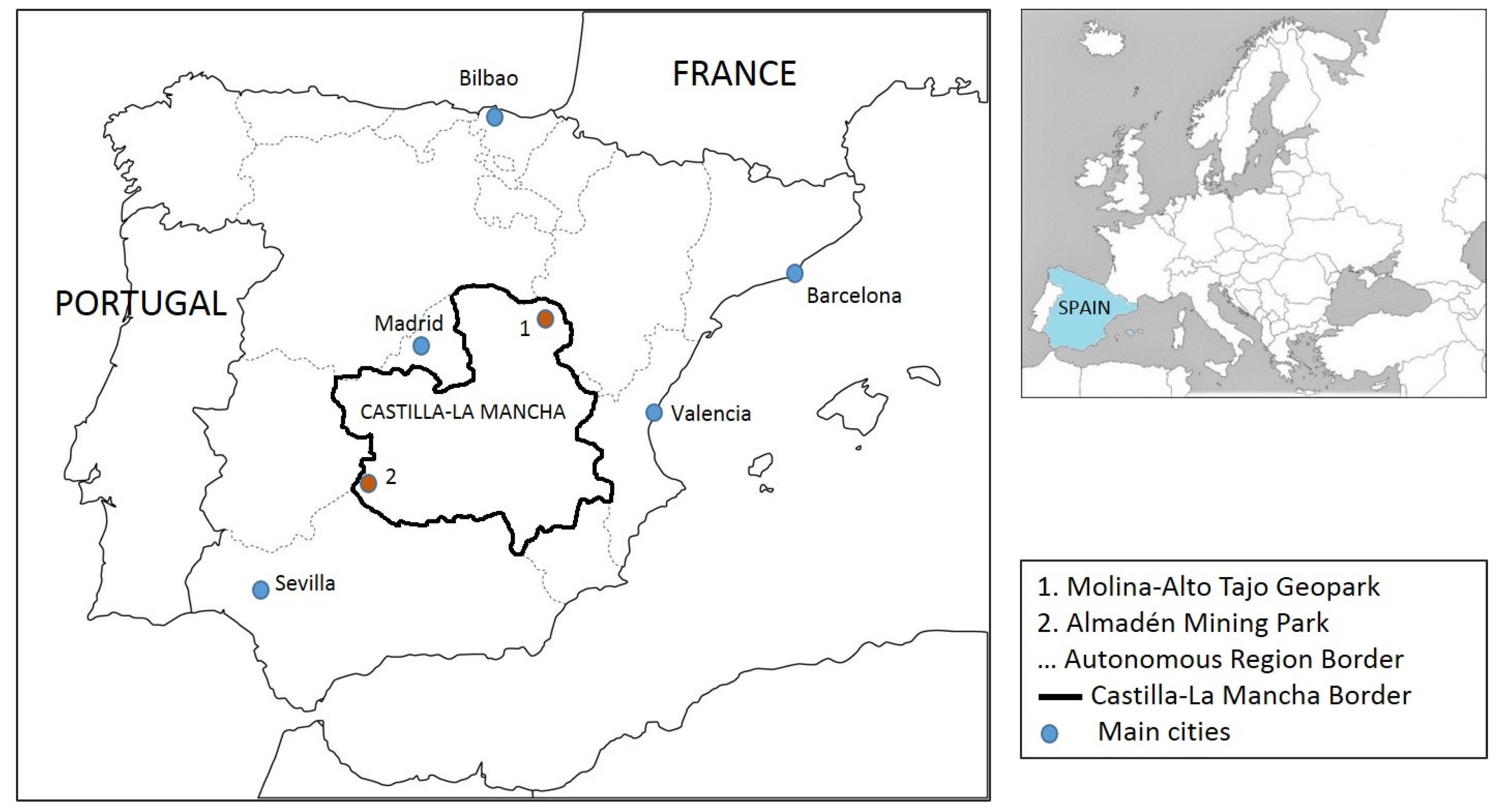
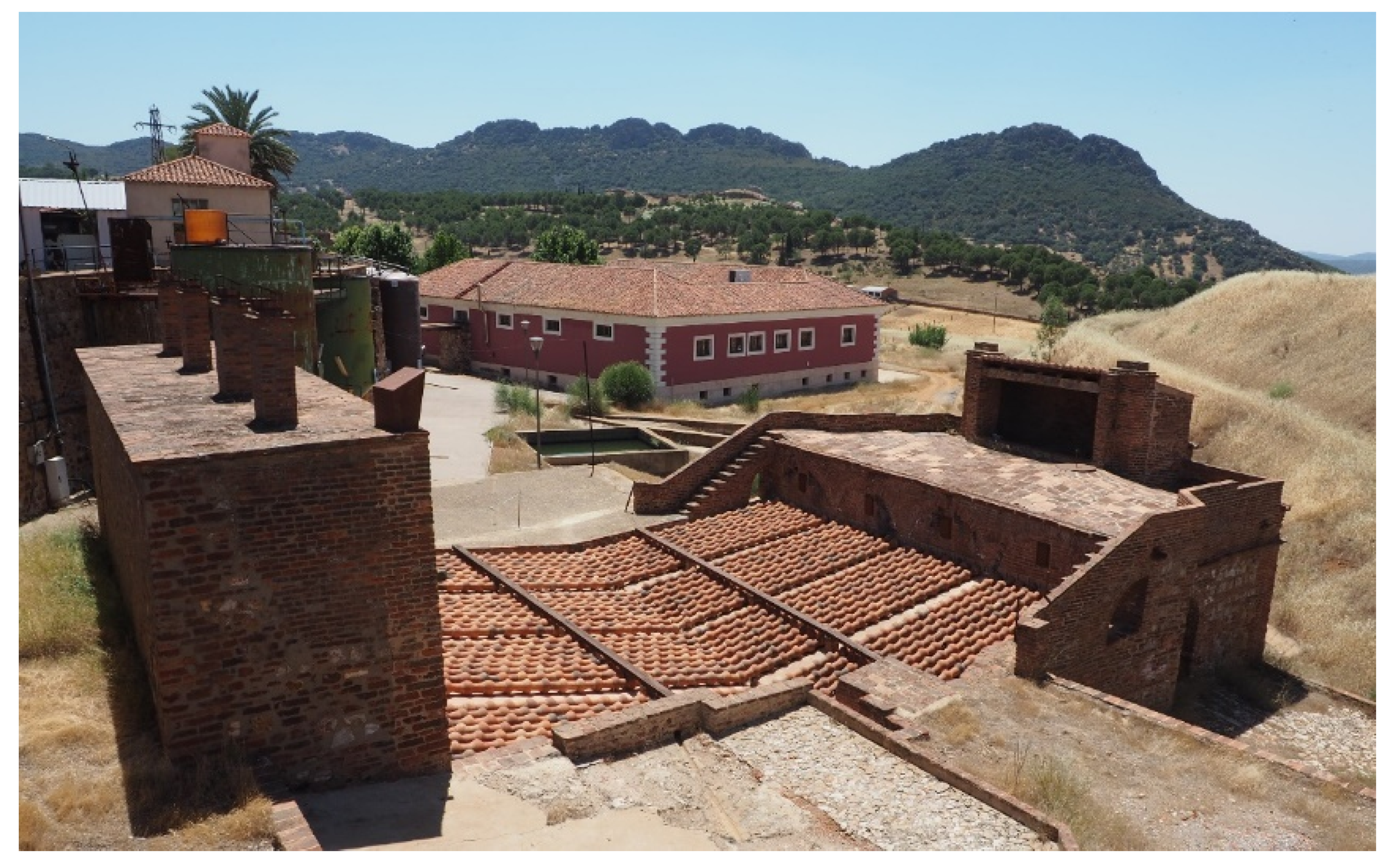


