Analysing and Applying Stakeholder Perceptions to Improve Protected Area Governance in Ugandan Conservation Landscapes

 ,
, 
Abstract
1. Introduction
2. Materials and Methods
3. Results
3.1. Main Perceptions Found With SenseMaker®
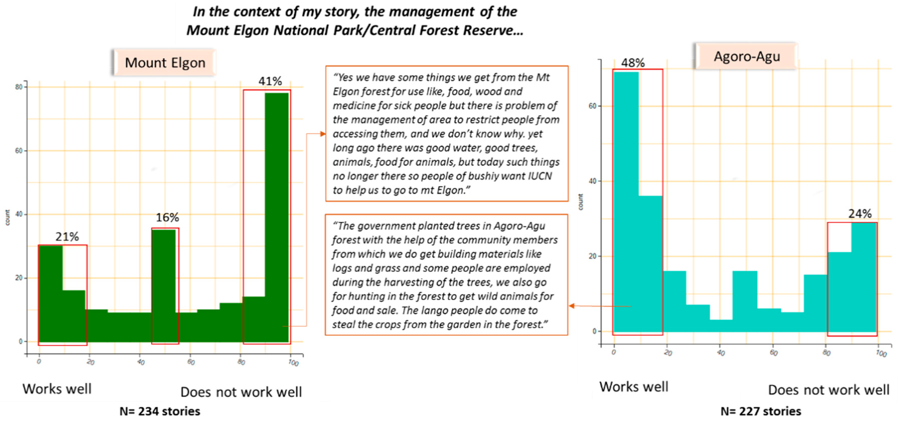
3.1.1. Inclusivity of the Governance at a Landscape Level
3.1.2. Community Participation in Decision-Making
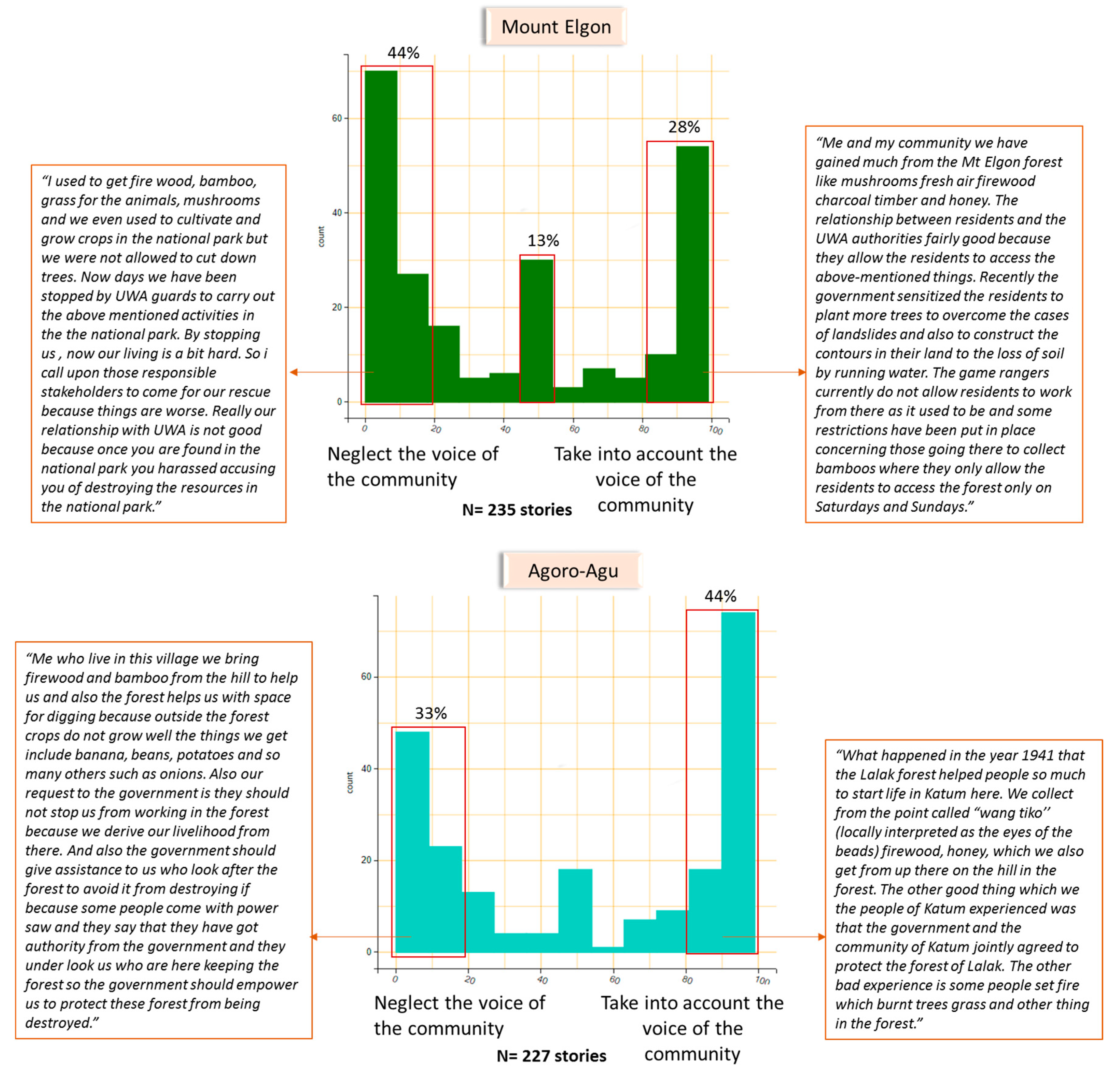
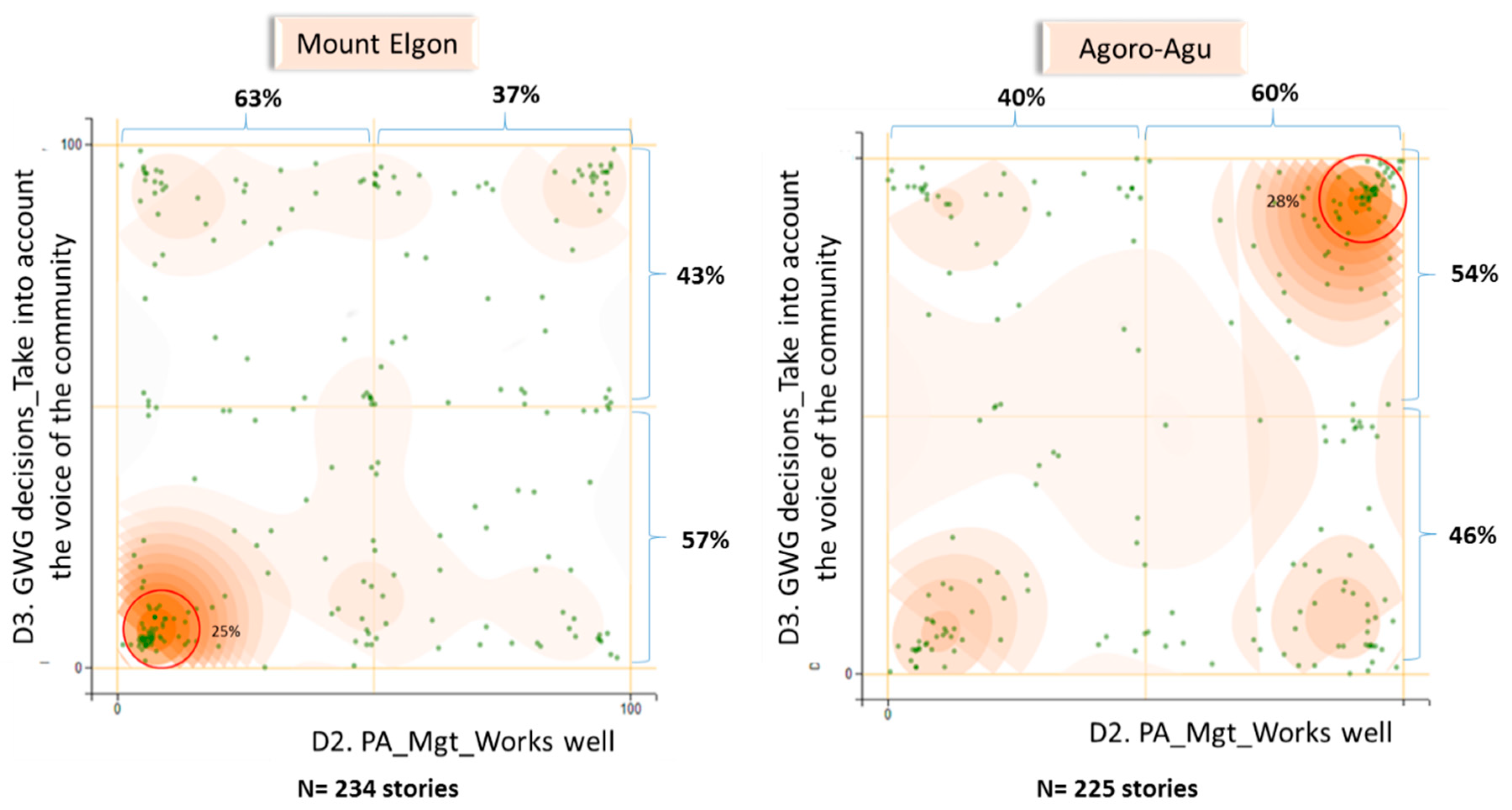
3.1.3. Fairness in Decision-Making Processes
3.2. Presenting Perceptions Back to the Communities
3.3. Identified Actions Emerging From Workshop and Current State of Implementation
3.3.1. Improving Governance at the Landscape Level
3.3.2. Improving Governance at the Protected Area Level
3.3.3. Improving Governance of CFM Groups
3.3.4. Improving Community Livelihoods and Reducing Pressure on the PAs Resources
4. Discussion
4.1. Influence of History of Protected Area Establishment on Perceptions
4.2. Influence of Current and Past Relationship With Governmental Authorities on Perceptions
4.3. Critique of the Method
5. Conclusions
5.1. Divergences Between Policy and Practice
5.2. The Value of Capturing Perceptions for Decision-Making and Adaptive Management
5.3. The Communities Feedback Process and Why it Matters for Improving Protected Area Landscape Governance
Author Contributions
Funding
Acknowledgments
Conflicts of Interest
Appendix A


References
- Denier, L.; Scherr, S.; Shames, S.; Chatterton, P.; Hovani, L.; Stam, N. The Little Sustainable Landscapes Book: Achieving Sustainable Development through Integrated Landscape Management. Available online: https://www.cifor.org/knowledge/publication/6767/ (accessed on 8 May 2020).
- Blomley, T.; Walters, G. (Eds.) A Landscape for Everyone: Integrating Rights-based and Landscape Governance Approaches; International Union for Conservation of Nature: Gland, Switzerland, 2019. [Google Scholar]
- Scherr, S.J.; Shames, S.; Friedman, R. Defining Integrated Landscape Management for Policy Makers. EcoAgriculture Policy Focus 2013, 10, 1. [Google Scholar]
- Reed, J.; Deakin, L.; Sunderland, T. What are ‘Integrated Landscape Approaches’ and how effectively have they been implemented in the tropics: A systematic map protocol. Environ. Evid. 2015, 4, 2. [Google Scholar] [CrossRef]
- Noss, R.F. A Regional Landscape Approach to Maintain Diversity. BioScience 1983, 33, 700–706. [Google Scholar] [CrossRef]
- Palomo, I.; Montes, C.; Martín-López, B.; González, J.A.; García-Llorente, M.; Alcorlo, P.; Mora, M.R.G. Incorporating the Social–Ecological Approach in Protected Areas in the Anthropocene. BioScience 2014, 64, 181–191. [Google Scholar] [CrossRef]
- Brown, J.; Mitchell, B. Landscape stewardship: New directions in conservation of nature and culture. George Wright Forum 2000, 70–79. [Google Scholar]
- Brown, J.; Mitchell, N.; Beresford, M. (Eds.) The Protected Landscape Approach: Linking Nature, Culture, and Community; IUCN--The World Conservation Union: Gland, Switzerland, 2005; ISBN 978-2-8317-0797-6. [Google Scholar]
- Wu, J. Landscape sustainability science: Ecosystem services and human well-being in changing landscapes. Landscape Ecol. 2013, 28, 999–1023. [Google Scholar] [CrossRef]
- Jeffrey, A.S.; Sunderland, T.C.H.; Ghazoul, J.; PFund, J.-L.; Sheil, D.; Meijaard, E.; Venter, M.; Boedhihartono, A.; Day, M.; Garcia, C.; et al. Ten principles for a landscape approach to reconciling agriculture, conservation, and other competing land uses. Proc. Natl. Acad. Sci. USA 2013, 110, 8349–8356. [Google Scholar]
- Reed, J.; Van Vianen, J.; Deakin, E.L.; Barlow, J.; Sunderland, T. Integrated landscape approaches to managing social and environmental issues in the tropics: Learning from the past to guide the future. Glob. Chang. Biol. 2016, 22, 2540–2554. [Google Scholar] [CrossRef]
- Bennett, N.J.; Dearden, P. From measuring outcomes to providing inputs: Governance, management, and local development for more effective marine protected areas. Mar. Policy 2014, 50, 96–110. [Google Scholar] [CrossRef]
- Oldekop, J.A.; Holmes, G.; Harris, W.E.; Evans, K.L. A global assessment of the social and conservation outcomes of protected areas: Social and Conservation Impacts of Protected Areas. Conserv. Biol. 2016, 30, 133–141. [Google Scholar] [CrossRef]
- Campese, J.; Borrini-Feyerabend, G. Human Rights-Based Approaches to Conservation: Promise, Progress, … and Pitfalls?’. In Forests and People Property, Governance, and Human Rights; Sikor, T., Stahl, J., Eds.; Earthscan: London, UK, 2011; pp. 47–62. [Google Scholar]
- Commission of Environmental, Economic and Social Policy; IUCN. An Introduction to the IUCN Natural Resource Governance Framework (NRGF); International Union for Conservation of Nature: Washington, DC, USA, 2019. [Google Scholar]
- Kozar, R.; Buck, L.E.; Barrow, E.; Sunderland, T.C.H.; Catacutan, D.E.; Planicka, C.; Hart, A.K.; Wil-lemen, L. Toward Viable Landscape Governance Systems: What Works; EcoAgriculture Partners: Washington, DC, USA, 2014. [Google Scholar]
- Mansourian, S.; Aquino, L.; Erdmann, T.K.; Pereira, F.A. A Comparison of governance challenges in forest restoration in Paraguay’s privately-owned forests and Madagascar’s co-managed state forests. Forests 2014, 5, 763–783. [Google Scholar] [CrossRef]
- Ros-Tonen, M.A.F.; Reed, J.; Sunderland, T. From Synergy to Complexity: The Trend Toward Integrated Value Chain and Landscape Governance. Environ. Manag. 2018, 62, 1–14. [Google Scholar] [CrossRef] [PubMed]
- Borrini-Feyerabend, G.; Dudley, N.; Jaeger, T.; Lassen, B.; Broome, N.P.; Philips, A.; Sandwith, T. Governance of protected areas: From understanding to action. Best Pract. Prot. Area Guidel. Ser. 2013, 20, 1–125. [Google Scholar]
- Oyono, P.R.; Mandondo, A. Inclusive Decision-Making in Natural Resource Governance. In Natural Resource Governance Framework Conceptual Paper; IUCN: Washington, DC, USA, 2017. [Google Scholar]
- Springer, J. Initial Design Document for A Natural Resource Governance Framework; International Union for Conservation of Nature: Gland, Switzerland, 2016; p. 14. [Google Scholar]
- Cornwall, A. Making Spaces, Changing Places: Situating Participation in Development. IDS Work. Pap. 2002, 170. [Google Scholar]
- Walters, G.; Schleicher, J.; Hymas, O.; Coad, L. Evolving hunting practices in Gabon: Lessons for community-based conservation interventions. Ecol. Soc. 2015, 20. [Google Scholar] [CrossRef]
- Giles-Vernick, T. Cutting the Vines for the Past: Environmental Histories of the Central African Rain Forest; University Press of Virginia: Charlottesville, VA, USA, 2002. [Google Scholar]
- Bluwstein, J. From colonial fortresses to neoliberal landscapes in Northern Tanzania: A biopolitical ecology of wildlife conservation. J. Political Ecol. 2018, 25, 144. [Google Scholar] [CrossRef]
- Gilli, M.; Cote, M.; Walters, G. Gatekeeping Access: The Dual Nature of Shea Land Formalization in Ghana’s CREMA. Master’s Thesis, Zurich University of Applied Sciences, Winterthur, Switzerland, 2020. submitted. [Google Scholar]
- Szaboova, L.; Brown, K.; Fisher, J.A. Access to Ecosystem Benefits: More than Proximity. Soc. Nat. Resour. 2020, 33, 244–260. [Google Scholar] [CrossRef]
- Blackie, R.; Sunderland, T. Mapping Landscape Guidelines and Principles to the Aichi Targets; Center for International Forestry Research (CIFOR): Bogor, Indonesia, 2015. [Google Scholar]
- Langston, J.D.; McIntyre, R.; Falconer, K.; Sunderland, T.; van Noordwijk, M.; Boedhihartono, A.K. Discourses mapped by Q-method show governance constraints motivate landscape approaches in Indonesia. PLoS ONE 2019, 14, e0211221. [Google Scholar] [CrossRef]
- Bennett, N.J. Using perceptions as evidence to improve conservation and environmental management. Conserv. Biol. 2016, 30, 582–592. [Google Scholar] [CrossRef]
- Eagles, P.F.J.; Romagosa, F.; Buteau-Duitschaever, W.C.; Havitz, M.; Glover, T.D.; McCutcheon, B. Good governance in protected areas: An evaluation of stakeholders’ perceptions in British Columbia and Ontario Provincial Parks. J. Sustain. Tour. 2013, 21, 60–79. [Google Scholar] [CrossRef]
- Webb, E.L.; Maliao, R.J.; Siar, S.V. Using local user perceptions to evaluate outcomes of protected area management in the Sagay Marine Reserve, Philippines. Environ. Conserv. 2004, 31, 138–148. [Google Scholar] [CrossRef]
- Blaikie, P. Changing Environments or Changing Views? A Political Ecology for Developing Countries. Geography 1995, 80, 203–214. [Google Scholar]
- Plumptre, A.J.; Ayebare, S.; Behangana, M.; Forrest, T.G.; Hatanga, P.; Kabuye, C.; Kirunda, B.; Kityo, R.; Mugabe, H.; Namaganda, M.; et al. Conservation of vertebrates and plants in Uganda: Identifying Key Biodiversity Areas and other sites of national importance. Conserv. Sci. Pract. 2019, 1. [Google Scholar] [CrossRef]
- Luke, Q.; Beentje, H. African floras: Coverage and uses. 2016, unpublished. [Google Scholar]
- Kalema, J.; Namaganda, M.; Bbosa, G.; Ogwal-Okeng, J. Diversity and status of carnivorous plants in Uganda: Towards identification of sites most critical for their conservation. Biodivers. Conserv. 2016, 25, 2035–2053. [Google Scholar] [CrossRef]
- Pomeroy, D.; Tushabe, H.; Loh, J. The State of Uganda’s Biodiversity 2017; National Biodiversity Data Bank: Kampala, Uganda, 2017. [Google Scholar]
- Gizachew, B.; Solberg, S.; Puliti, S. Forest Carbon Gain and Loss in Protected Areas of Uganda: Implications to Carbon Benefits of Conservation. Land 2018, 7, 138. [Google Scholar] [CrossRef]
- Republic of Uganda. National Biodiversity Strategy and Action Plan II; National Environment Management Authority: Nairobi, Kenya, 2016.
- Howard, P.; Davenport, T.; Kigenyi, F. Planning conservation areas in Uganda’s natural forests. Oryx 1997, 31, 253–264. [Google Scholar] [CrossRef]
- Petursson, J.G.; Vedeld, P.; Sassen, M. An institutional analysis of deforestation processes in protected areas: The case of the transboundary Mt. Elgon, Uganda and Kenya. Forest Policy Econ. 2013, 26, 22–33. [Google Scholar] [CrossRef]
- Anderson, D.; Grove, R. Introduction: The scramble for Eden: Past, present and future in African conservation. In Conservation in Africa; Anderson, D., Grove, R.H., Eds.; Cambridge University Press: Cambridge, UK, 1988; pp. 1–12. ISBN 978-0-521-34199-8. [Google Scholar]
- Adams, W.H.; Hutton, J. People, Parks and Poverty: Political Ecology and Biodiversity Conservation. Conserv. Soc. 2007, 5, 147–183. [Google Scholar]
- Western, D.; Wright, R.M.; Strum, S.C. (Eds.) Natural Connections: Perspectives in Community-Based Conservation; Island Press: Washington, DC, USA, 1994; ISBN 978-1-55963-345-1. [Google Scholar]
- Adams, W.H.; Hulme, D. If community conservation is the answer in Africa, what is the question? Oryx 2001, 35, 193–200. [Google Scholar] [CrossRef]
- Turyahabwe, N.; Banana, A.Y. An overview of history and development of forest policy and legislation in Uganda. Int. For. Rev. 2008, 10, 641–656. [Google Scholar] [CrossRef]
- Nakangu Bugembe, B. State Craft in Natural Resources Management Structure of Ugand. Ph.D. Thesis, Makerere University, Kampala, Uganda, 2019. [Google Scholar]
- Republic of Uganda. State of Uganda’s Forestry; Ministry of Water and Environment, Forestry Sector Support Department: Kampala, Uganda, 2016.
- Uganda Wildlife Authority. UWA Strategic Plan; Uganda Wildlife Authority: Kampala, Uganda, 2015.
- UNEP-WCMC; IUCN. Protected Planet. The World Database on Protected Areas (WDPA); UNEP-WCMC and IUCN: Cambridge, UK, 2020. [Google Scholar]
- National Forestry Authority. Revised Forest Management Plan for Agoro-Agu Sector Central Forest Reserves For the period: 1st July 2018–30th June 2028; National Forestry Authority: Kampala, Uganda, 2018.
- Republic of Uganda. Statistical Datasets; Bureau of Statistics: Kampala, Uganda, 2016.
- Amone, C.; Muura, O. British Colonialism and the Creation of Acholi Ethnic Identity in Uganda, 1894 to 1962. J. Imp. Commonw. Hist. 2014, 42, 239–257. [Google Scholar] [CrossRef]
- Laruni, E. Regional and ethnic identities: The Acholi of Northern Uganda, 1950–1968. J. East. Afr. Stud. 2015, 9, 212–230. [Google Scholar] [CrossRef]
- Kobusingye, D.N. African youths; the forgotten category in land governance. A case study of post-conflict Acholi Region, Northern Uganda. Geoforum 2020, 109, 135–142. [Google Scholar] [CrossRef]
- Kapidžić, D. Public authority beyond hybrid governance: Creating throughput legitimacy in Northern Uganda. Peacebuilding 2018, 6, 127–143. [Google Scholar] [CrossRef]
- Hopwood, J. Women’s Land Claims in the Acholi Region of Northern Uganda: What Can Be Learned from What Is Contested. Int. J. Minor. Group Rights 2015, 22, 387–409. [Google Scholar] [CrossRef]
- Ker Kwaro Acholi. Principles and Practices of Customary Tenure in Acholiland; Ker Kwaro Acholi: Gulu, Uganda, 2008. [Google Scholar]
- Zhao, Y.; Feng, D.; Jayaraman, D.; Belay, D.; Sebrala, H.; Ngugi, J.; Maina, E.; Akombo, R.; Otuoma, J.; Mutyaba, J.; et al. Bamboo mapping of Ethiopia, Kenya and Uganda for the year 2016 using multi-temporal Landsat imagery. Int. J. Appl. Earth Obs. Geoinf. 2018, 66, 116–125. [Google Scholar] [CrossRef]
- Gorsevski, V.; Geores, M.; Kasischke, E. Human dimensions of land use and land cover change related to civil unrest in the Imatong Mountains of South Sudan. Appl. Geogr. 2013, 38, 64–75. [Google Scholar] [CrossRef]
- Shiraishi, S. Part-time herdsmen: The herding camps of a mountainous agricultural people. In Nomads: Living in the Wilderness of Africa; Tanaka, J., Sato, S., Sugawara, K., Ohta, I., Eds.; Showado: Kyoto, Japan, 2010. [Google Scholar]
- Were, G.S. The Bagisu and their past: Some notes on their legends about creation, the origins of death, the economy of their ancestors and the phenomenon of Kintu. Transafrican J. Hist. 1982, 11, 184–195. [Google Scholar]
- Mwakikagile, G. Ethnicity and National Identity in Uganda: The Land and Its People; New Africa Press: Dar es Salaam, Tanzania, 2009; ISBN 978-9987-9308-7-6. [Google Scholar]
- Sassen, M.; Sheil, D.; Giller, K.E.; ter Braak, C.J.F. Complex contexts and dynamic drivers: Understanding four decades of forest loss and recovery in an East African protected area. Biol. Conserv. 2013, 159, 257–268. [Google Scholar] [CrossRef]
- Olupot, W.; Plumptre, A.J. Conservation Research in Uganda’s Forests: A Review of Site History, Research, and Use of Research in Uganda’s Forest Parks and Budongo Forest Reserve; Novinka: New York, NY, USA, 2012; ISBN 978-1-62257-263-2. [Google Scholar]
- Mugagga, F.; Kakembo, V.; Buyinza, M. A characterisation of the physical properties of soil and the implications for landslide occurrence on the slopes of Mount Elgon, Eastern Uganda. Nat. Hazards 2012, 60, 1113–1131. [Google Scholar] [CrossRef]
- Vedeld, P.; Cavanagh, C.; Petursson, J.; Nakakaawa, C.; Moll, R.; Sjaastad, E. The political economy of conservation at Mount Elgon, Uganda: Between local deprivation, regional sustainability, and global public goods. Conserv. Soc. 2016, 14, 183. [Google Scholar] [CrossRef]
- Gosalamang, D.; Vedeld, P.; Gombya-Ssembajjwe, W. From Forest Reserve to National Park-Change in Legal Status and Impacts on Livelihoods and Biodiversity Resources, Mt. Elgon, Uganda; Noragric Working Paper No. 44; Department of International Environment and Development Studies, Noragric Norwegian University of Life Sciences (UMB): Aas, Norway, 2008. [Google Scholar]
- Norgrove, L. Parking Resistance and Resisting the Park: The Theory and Practice of National Park Management, a Case Study of Mount Elgon, Uganda. Ph.D. Thesis, University of Michigan, Ann Arbor, MI, USA, 2003. [Google Scholar]
- Davenport, T.; Howard, P.; Dickinson, C. Mount Elgon National Park. Biodiversity Report; Uganda Forestry Department: Kampala, Uganda, 1996. [Google Scholar]
- Howard, P.C. Nature Conservation in Uganda’s Tropical Forest Reserves; IUCN, International Union for Conservation of Nature and Natural Resources: Gland, Switzerland, 1991; ISBN 978-2-8317-0085-4. [Google Scholar]
- IUCN; WCMC (Eds.) Guidelines for Protected Area Management Categories; IUCN/UICN: Cambridge, UK, 1994; ISBN 978-2-8317-0201-8. [Google Scholar]
- Uganda Wildlife Authority. Uganda Wildlife Authority Collaborative Management Strategy; Uganda Wildlife Authority: Kampala, Uganda, 2000.
- Vanen, C. Evicted in the Name of Nature: The Process of Eviction and Its Impact on Local Rural Livelihoods in Mount Elgon, Uganda. Master’s Thesis, Norwegian University of Life Sciences, Ås, Norway, 2009. [Google Scholar]
- Sensemaker; Cognitive Edge: Singapore, 2020.
- Dervin, B. Sense-making theory and practice: An overview of user interests in knowledge seeking and use. J. Knowl. Manag. 1998, 2, 36–46. [Google Scholar] [CrossRef]
- Fisher, W.R. The Narrative Paradigm: In the Beginning. J. Commun. 1985, 35, 74–89. [Google Scholar] [CrossRef]
- Beam Exchange; Leveraging Economic Opportunities. Testing Tools for Assessing Systemic Change: Sensemaker; LEO Report #44; USAID & UKAID: Washington, DC, USA, 2016.
- Deprez, S.; Huyghe, C.; Van Gool Maldonado, C.; Vredeseilanden/VECO. Using Sensemaker to Measure, Learn and Communicate about Smallholder Farmer Inclusion. Case Report Thematic Learning Programme on Planning, Monitoring and Evaluation of Complex Processes of Social Change; A Better Deal for Farmers: Leuven, Belgium, 2012. [Google Scholar]
- Milne, K.M.G. Can sense-making tools inform adaptation policy? A practitioner’s perspective. Ecol. Soc. 2015, 20. [Google Scholar] [CrossRef]
- Van der Merwe, S.E.; Biggs, R.; Preiser, R.; Cunningham, C.; Snowden, D.J.; O’Brien, K.; Jenal, M.; Vosloo, M.; Blignaut, S.; Goh, Z. Making Sense of Complexity: Using SenseMaker as a Research Tool. Systems 2019, 7, 25. [Google Scholar] [CrossRef]
- Jeha, L. Equity, Sustainability and Incentive-Based Conservation Measures. Community Reflections from Mt. Elgon, Uganda. Ph.D. Thesis, The University of York, York, UK, 2016. [Google Scholar]
- IUCN; Eilu, G. Review of Effectiveness of Multiple-Use Programme in Mount Elgon National Park; IUCN: Kampala, Uganda, 2018. [Google Scholar]
- Uganda Wildlife Authority. Mount Elgon National Park, Man and Biosphere Reserve, General Management Plan (Year 2020/2021-2029/2030); Uganda Wildlife Authority: Kampala, Uganda, 2020.
- Republic of Uganda. The Wildlife Act; Republic of Uganda: Kampala, Uganda, 2019. [Google Scholar]
- Omoding, J.; Walters, G.; Carvalho, S.; Cracco, M.; Langoya, C.D.; Gaster Kiyingi, K.; Kumar, C.; Reinhard, F.; Ssenyongo, E.; Twinomuhangi, L. Implementing the landscape approach in the Agoro-Agu region of Uganda. Parks 2020, 26, 99–110. [Google Scholar]
- Berkes, F. Devolution of environment and resources governance: Trends and future. Environ. Conserv. 2010, 37, 489–500. [Google Scholar] [CrossRef]
- Freudenthal, E.; Ferrari, M.F.; Kenrick, J.; Mylne, A. The Whakatane Mechanism: Promoting Justice in Protected Areas. Nomadic Peoples 2012, 16, 84–94. [Google Scholar] [CrossRef]
- IUCN. Making sense of community natural resource governance perceptions. Forest Brief 2020, 26. [Google Scholar]


© 2020 by the authors. Licensee MDPI, Basel, Switzerland. This article is an open access article distributed under the terms and conditions of the Creative Commons Attribution (CC BY) license (http://creativecommons.org/licenses/by/4.0/).
Share and Cite
Omoding, J.; Walters, G.; Andama, E.; Carvalho, S.; Colomer, J.; Cracco, M.; Eilu, G.; Kiyingi, G.; Kumar, C.; Langoya, C.D.; et al. Analysing and Applying Stakeholder Perceptions to Improve Protected Area Governance in Ugandan Conservation Landscapes. Land 2020, 9, 207. https://doi.org/10.3390/land9060207
Omoding J, Walters G, Andama E, Carvalho S, Colomer J, Cracco M, Eilu G, Kiyingi G, Kumar C, Langoya CD, et al. Analysing and Applying Stakeholder Perceptions to Improve Protected Area Governance in Ugandan Conservation Landscapes. Land. 2020; 9(6):207. https://doi.org/10.3390/land9060207
Chicago/Turabian StyleOmoding, James, Gretchen Walters, Edward Andama, Salete Carvalho, Julien Colomer, Marina Cracco, Gerald Eilu, Gaster Kiyingi, Chetan Kumar, Council Dickson Langoya, and et al. 2020. "Analysing and Applying Stakeholder Perceptions to Improve Protected Area Governance in Ugandan Conservation Landscapes" Land 9, no. 6: 207. https://doi.org/10.3390/land9060207
APA StyleOmoding, J., Walters, G., Andama, E., Carvalho, S., Colomer, J., Cracco, M., Eilu, G., Kiyingi, G., Kumar, C., Langoya, C. D., Nakangu Bugembe, B., Reinhard, F., & Schelle, C. (2020). Analysing and Applying Stakeholder Perceptions to Improve Protected Area Governance in Ugandan Conservation Landscapes. Land, 9(6), 207. https://doi.org/10.3390/land9060207