The Nexus between Peri-Urban Transformation and Customary Land Rights Disputes: Effects on Peri-Urban Development in Trede, Ghana


Chair of Land management, Faculty of Aerospace and Geodesy, Technical University of Munich (TUM), 80333 Munich, Germany
*
Author to whom correspondence should be addressed.
Land 2020, 9(6), 187; https://doi.org/10.3390/land9060187
Submission received: 6 May 2020
/
Revised: 26 May 2020
/
Accepted: 28 May 2020
/
Published: 5 June 2020
(This article belongs to the Special Issue Land, Women, Youths, and Land Tools or Methods)
Abstract
:Typically, peri-urban areas are havens and vulnerable receptors of customary land rights (CLRs) disputes due to the intrusion of urban activities or an uncoordinated mix of both. Although it is a dictum that CLRs cause setbacks to socioeconomic and spatial development, there seems to be a paucity of empirical studies on the effects of the CLRs disputes on the development of peri-urban areas, especially in developing countries, such as Ghana. This study addresses this issue by establishing a link between peri-urban transformation and emerging CLRs disputes, while assessing the effects of these disputes on the development of peri-urban areas. The study adopted a problem-centered mixed methods approach with a focus on the case of Trede, a town in Ghana transitioning from rural to urban status. Findings reveal that the changes leading to enhancing of peri-urban transformation are also the same changes inducing CLRs disputes in the area. It was found that the implementation of a local land use plan is a critical driver of CLRs disputes in Trede. A land-use plan implemented as a major step in converting rural lands into urban plots, triggered tenurial changes, land market development, high land values, loss of agricultural land, etc., which become recipes for the CLRs disputes in the study area. These CLRs disputes have hatched detrimental consequences on the economic, social, and physical developmental trajectories of Trede. As a way forward, the study proposes measures for peri-urban land management and CLRs dispute prevention.
1. Introduction
The challenge posed by customary land rights disputes (defined as any claim, disagreement, or contestations over the right to use, control, and management of customary lands) in developing countries has been well documented in literature [1,2,3,4]. The dispute-affected areas and countries are known to suffer detrimental consequences in their economic, social, and physical developmental trajectories. However, the effects of customary land rights (CLRs) disputes vary across the different spatial continuums—from rural to peri-urban to urban areas. Typically, peri-urban areas are more gravid with the effects of customary land disputes due to the frequent and enormous changes that occur to their land use patterns. There is increasing evidence that peri-urban areas have become contested zones when compared with rural and urban areas, mostly because it is a geography where rural and urban functions occur side-by-side [1,4]. Particularly in peri-urban areas, there is the blur of rural and urban boundary, as such boundaries of traditionally urban land and rural land remain a core debate in peri-urban studies. Similarly, the Global Land Tool Network (GLTN) [3] noted that the uncertainty of ‘what is rural’ and ‘what is urban’ land in peri-urban areas has caused the regulation of different land tenure rights to become subjected to different land management regimes and administration system which may come in conflict leading to disputes, contestation, and violence. These have resulted in significant peri-urban development issues.
Ghana is one of the countries, at least within the Sub-Saharan African region, facing a lot of challenges in its peri-urban development. Legal pluralism in land tenure is recognized and practiced in Ghana. Consequently, customary land laws and Statutes contemporaneously exist in regulating land administration and governance in Ghana. In peri-urban areas of Ghana the management of land tenure operates within a plural environment. The construction of the peri-urban land involves two major actors; the customary authority and the statutory authority. Despite the pluralistic nature of land tenure system in Ghana’s peri-urban areas, most developments are undertaken within the customary land tenure regime. Therefore, any barrier confronting customary land rights have detrimental implications on the transition from rural to peri-urban. The management of the transition of rural areas solely by customary authorities without statutory intervention affect the transition process [4,5]. According to Mends [4], the inability of customary authorities to manage changing customary tenure systems (defined as the traditional rules and regulations that govern the holding, use and transfer of interest and rights in land) have resulted in tenure insecurity, land ownership conflicts, and boundary disputes.
Several factors have resulted in significant changes in land tenure practices and land rights in peri-urban areas. Chauveau [6] noted that urbanization and rapid population have given rise to the high demand for rural land. Pressure from demand has caused the rapid transformation of customary lands to peri-urban lands to engender changes in the customary tenure system [4,7,8].The transformation manifests mainly in the physical development and conversion of agricultural land uses to non-agricultural land uses. Communal land rights, commonly practiced in rural areas, are gradually changing to individualized land rights in peri-urban areas [6,9,10]. Wehrmann [11] also observed that the emergence of peri-urban areas has come with new forms of land tenure systems, which may not be compatible with the customary land tenure system and, as such, contradict customary rules.
It is worth noting that changes in customary land tenure system move in tandem with changes in ownership, control, and land uses. Consequently, new actors, such as urban elites and foreign investors, move into peri-urban areas to compete for land for residential, commercial, and speculative purposes [12,13]. The change in land uses, ownership, and control of land in peri-urban areas have therefore been characterized by intense competition engendering exclusion to access to land leading to CLRs disputes [2,11,14,15]. For instance, the conversion of agricultural lands has made local farmers in peri-urban become subjects of expropriation. Many farmlands are lost to residential and commercial developments without fair compensation to farmers [16]. Some local farmers, in their attempt to defend their rights, enter direct struggle with chief, whiles others physically attack new buyers from entering their lands or sometimes go to the extent of destroying newly built-structures [13,17]. These are some of the undesirable consequences of customary land rights disputes.
The problem of customary land rights disputes thwart the development potentials of peri-urban areas in Ghana. Although policymakers do realize that CLRs disputes pose serious setbacks to development, the underlying effects of CLRs disputes on the development of peri-urban areas remain largely unexplored. It is within this context that the study seeks, by way of its purpose, to examine the effects of CLRs disputes in the context of peri-urban areas through a case study of Trede, a town which is currently undergoing a transition from rural to urban. This study is critical to informing policy for an efficient peri-urban land management and CLRs dispute prevention.
The remaining section of this paper is structured as follows: first, we introduce the conceptual review of peri-urban, peri-urban transformation, development, and customary land tenure. Next, we discuss the data collection and analysis methodology which were employed to investigate the problem. We then present and discuss the results in respond to the study objectives. In the last section, we draw logical conclusion on the analysis and make recommendations towards policy reforms in managing peri-urban lands and CLRs dispute prevention.
2. Peri-Urbanization and Land Tenure: A Conceptual Review
The interrelated concepts of peri-urban, peri-urban transformation, development, and customary land tenure are examined in this section of the paper.
2.1. Putting Peri-Urban and Peri-Urban Transformation into Context
The term peri-urban is multi-dimensional and has been defined differently by various scholars. It has been described as a place, process, or concept. As a concept, peri-urban is when rural and urban activities meet; as a process, peri-urban is the gradual transformation of rural areas as they attain more urban characteristics; and as a place, it is the region between rural and urban zone [18]. In addition, studies, such as Reference [19,20,21], considered peri-urban as a geographical location. Some groups of researchers also considered peri-urban as a mental state of mind [22,23]. Similarly, the definition of peri-urban has been conceived differently across discipline and professions. The sociologists view peri-urban as areas of social compression or intensification where social stratification increases leading to conflict and social evolution [23]. The planners consider peri-urban as a transitional zone between urban area and rural area predominately under urban influence [24,25]. The environmentalist conceptualizes peri-urban as an interface of heterogeneous mosaic of natural ecosystems, agro-ecosystems, and urban ecosystems affected by rural and urban interactions [26].
Even though there is still no universal definition for peri-urban, preponderances of urban researchers and policy analysts place higher priority on the place-based definition of peri-urban. However, Iaquinta and Drescher [23] argued that defining peri-urban as a geographical location is not satisfactory. They highlighted the need to incorporate socio-psychological and institutional components that characterize the reality of peri-urban areas in any definition. Meanwhile, Ravetz et al. [21] proposed that arriving at consensual definition of peri-urban was not realistic due to the disparate perspectives and contexts in which the concept is deployed and described. They suggested that it will be better to view peri-urban as a spatial phenomenon in continuous flux and transition. Nonetheless, researchers have recognized the complexity and diverse nature of the concept [26,27]. In this study, peri-urban area is regarded as an area of “tenurial transformation” [19] where customary lands transition into urban lands. This conceptualization is useful in providing an appropriate context for examining the land dispute types that come along with the tenurial transformation in peri-urban areas.
Peri-urbanization is a global phenomenon; however, the trend of peri-urbanization varies across globe. While some researchers have viewed peri-urbanization as harmful to physical environment, others have associated it with socioeconomic development [28,29]. According to Chiris [28], peri-urbanization in developed countries is characterized by industrial development, whereas, in most developing countries, the process has resulted to sprawl endangering the physical environment. On the other hand, Setterthweite et al. [29] argued that land problems, such as sprawl, are not the resultant effect of peri-urbanization but, rather, the lack of appropriate management of the rural-urban interface by planning authorities. Peri-urban areas in Ghana consist of mainly customary lands; as a result, the management of these areas are largely under the control of customary authorities, with limited interventions from state actors. Due to the nature of land management in peri-urban areas of Ghana, the process of transformation is, to a large extent, unplanned, leading to land disputes.
2.2. The Interface between Land Tenure and Peri-Urban Development
To appreciate the implications of land tenure on peri-urban development, it is useful to demystify the terms ‘land tenure’ and ‘development’. Land tenure has been defined as the laws, rules, and obligations governing how people hold land [30]. The Food and Agriculture Organization [31] considered land tenure as an institution invented by society to regulate human-land relationship. These suggest that land tenure provides an institutional structure (customarily or formally) for people to exercise their rights and interest in land.
On the other hand, development is the process of societal change that brings improvement in the quality of lives of people [32]. It symbolizes “the attainment and maintenance of a reasonable and acceptable standard of living, based on the traditions, institutions, values and standards of a given society” (Reference [30], p. 20). Development is usually equated with economic growth. While economic growth is one of the important components of development, other components, such as social and physical factors, exist. Development can be in the form of physical action, for instance, implementation of physical projects, like road infrastructures, community hospitals, etc. It could also come in the form of process change not involving any physical intervention. Regardless of the form, development affects people beliefs, traditions, and values [30].
Land tenure is an important aspect of institutional context of development in many developing countries [33]. Issues of land tenure have become a global concern. In May 2012, the Committee on World Food Security (CFS), initiated the “Voluntary Guidelines on the Governance of Tenure of Land, Fisheries and Forests” at the Global Food Security Symposium. These guidelines were adopted with the aim of providing an overarching framework for tenure systems capable of ensuring tenure security and equitable access to land for all. In addition, the GLTN through UN-Habitat has been working on developing pro-poor land use planning tools to secure tenure in most developing countries. Other laudable initiatives, such as the Sustainable Development Goals (SDGs) adopted in 2015 at the UN Sustainable Development Summit (Agenda 2030), are all aimed at reducing poverty and ensuring sustainable development through secure land tenure systems.
Land tenure is crucial for socio-economic development. Kasanga [30] asserted that land tenure forms the basis not only for agricultural production but also for social and economic development. In a similar view, De Soto [34] and Payne [33] emphasized that tenurial problems have adverse effects on economic development. Other studies have equated land tenure to economic development [8,17]. However, USAID [35] reported that estimating the impact of land tenure on economic development is a difficult and complex process to determine. Yet, outcome variables, such as poverty rates, land values, and agricultural productivity, can provide the bases for measuring the impact of land tenure on economic development. Nevertheless, land tenure can act as a considerable constraining factor impeding development. Nkwae [27] showed that tenure problems, such as tenure insecurity, litigations, land disputes, and loss of agriculture land, could compromise food security, land rights, and agricultural productivity, with detrimental effects on economic growth, and may act as a recipe for poverty. It is, therefore, necessary to conclude land tenure has a correlation with the development of any nation.
2.3. The Dynamic Customary Tenure System Versus Transformative Peri-Urban Area
Land tenure as part of the institutional context of peri-urban is subject to change as rural areas transform into peri-urban areas. In effect, there is an interrelationship between changes occurring in the peri-urban areas and changes in the land tenure. It is essential to note that the transition in peri-urban areas corresponds to changes in the customary tenure; thus, a sudden change in the social or economic fabric of peri-urban areas results to changes in customary tenure [27]. Twaib (1996), as cited in Nkwae [27], observed that “any change in the pattern of land ownership automatically carries with it changes in economic, family and social relationships”. This assertion reflects the views of Iaquinta and Drescher [23], who noted that peri-urban is reciprocal. This simply means that changes in peri-urban areas change people’s land relations, and vice versa.
The main change arising from customary land rights in peri-urban areas is the shift from collective ownership to individual rights. This view is echoed by Mends [4], who noted that the concept of customary land rights has evolved from the notion that land which was collectively owned by the community now belongs to the person who initially cultivated it. Thus, the communitarian approach gradually moves toward individualization. Wehrmann [11] observed that change from communitarian approach to individualization would not follow a smooth process but, rather, one that is characterized by tenure insecurity, contestations, and disputes. Boserup (1965), as cited in Wehrmann ([11], p. 85), also warned that "each new step on the road to private property in land may create less and not more security of tenure, and a vast amount of litigation is the obvious result". It is therefore necessary to understand the changes in land tenure as customary land transition to peri-urban land, the land disputes that comes along with, and how these disputes can be managed.
The customary tenure is regarded as flexible, dynamic, and can respond to changing socio-cultural and economic conditions [4,10,17]. However, Chauveau [6] found that the way in which customary tenure responds to changes varies substantially depending on the diversity of the area in context. In some cases, customary tenure still maintains some resilience despite the urban pressure. Notably, some traditional authorities have been steadfast in maintaining the customary land management practices. On the contrary, the customary tenure could be entirely eroded due to changes in the composition of the indigenous population. Chauveau et al. [5] suggest that where customary land tenure has eroded, government intervention is required for effective land management. In the peri-urban areas where this problem is common, Reference [26,36] claim that policymakers are not capable of addressing land management problems because of the increasingly complex nature of peri-urban areas. To propose a solution to this quandary, this paper makes recommendations towards policy reforms in managing peri-urban lands.
3. Methodology
3.1. Description of Case Study Area
Trede is situated south of Ashanti region and is about 16 km from the regional capital, Kumasi (see Figure 1). Trede has an estimated land size of about 1200 acres with a population of 5438 people according to the 2010 population Census [37]. The town lies within the huge conurbation area on or near the road from Kumasi to Obuasi. Kumasi is fast growing, and this has resulted in the emergence of urban sprawl at the fringes of the city. The sprawl of Kumasi has fast encroached its neighboring rural communities, including Trede. The proximity of Trede to Kumasi and the consequences of urban sprawl facilitated the transformation of the town from rural to per-urban. However, on the other side of proximity are some shortcomings. As an emerging peri-urban area, the issue of how to meet the demand for rural lands for urban development and how to manage the rural-urban interface have presented serious land problems in the area. The choice of the above case study area was based on the persistence of land disputes in the area. Hence, the selection of the area for the study was done purposively.
3.2. Research Methods
The present study sought to examine how the study area, Trede, transformed from rural to peri-urban status and how the problem of customary land rights disputes has affected the development in the area. The study approaches this problem by striving to answer three key research questions. These questions include: (1) What process did Trede undergo in its transformation from rural land to peri-urban land? (2) Did this process lead to increased customary land disputes, and if so, what are the characteristics of these disputes (including their types, drivers, effects, and consequences) on the development of the area? (3) In what ways can the situation be improved? By investigating these questions, it was possible to grasp the past and the present situations of land related problems in Trede, as well as discern ideas to improve the situation going forward.
Considering the complex and dynamic nature of peri-urban areas and land disputes (and the nature of the questions under investigation), it will be challenging to explore the associated issues using a single method. Thus, a mixed methods research approach was adopted to investigate the problem. This approach is more problem-centered and is suitable for gaining a deeper understanding of complex problems [38]. It offers the opportunity to counterbalance the weaknesses of each method. The requirement of using mixed method renders it appropriate to collect and analyze both qualitative and quantitative data either at the same time or different stages. Therefore, data collection and analysis for the study was done simultaneously. A case study analysis through key informant interview, field observation and document review have been used to generate qualitative primary and secondary data. Quantitative descriptive data was also generated from household survey. In the context of the research problem under investigation, the qualitative data emanated from the case study analysis and quantitative data resulted from the households’ survey. In effect, a case study analysis of Trede was done using key informant interview, field observation document review, and maps to investigate the problem.
The case study was used to gain an in-depth understanding of the historical and present development in the town that influences its transition from rural to peri-urban, the customary tenure arrangements in the town, existing land disputes, evidences of the effects of these disputes, and the way forward in solving them. In-depth interviews were undertaken using semi-structured interview with traditional leaders, family heads, and state officials. These key informants were selected by purposive sampling technique since they are known to be involved in dispute resolution process and are in better position in answering questions on the causes of these disputes and interventions in strengthening the local disputes resolution mechanisms. In all, a total of six (6) traditional leaders and three (3) family heads were interviewed. Traditional leaders here constitute members from the palace who play key roles in the customary land dispute resolution, as well as members who have enough knowledge on the history of the town and can give an account on the transformation process of the town. Officials, including three (3) Senior Technical Officers from the Public and Vested Land Management Division (PVLMD), the District Planning Officer from Physical Planning Department (AKDA), Secretary of the Trede Stool lands, the District Land Surveyor from Physical Planning Department (AKDA), and three (3) personnel from the Otumfuo Land Secretariat (CLS), were interviewed. In all, nine (9) state officials were interviewed.
To bring to light the effects of land disputes on the spatial development of the town, some forms of observations were carried out on land parcels in the study area. This approach facilitated in identifying underdeveloped land within the area due to land disputes. Again, observations of the customary land dispute resolution process on two different occasions were undertaken. This was necessary to gain insights into how land dispute resolution procedures were organized and how efficient (process oriented) and effective (goals oriented) was the system. The Household survey has been used to collect information about demographic distribution, factors influencing change, and types of customary land disputes from landowners, developers, and users in the study area. The target population for the survey included landowners, developers, and land users from the study area who were mostly the victims of customary land disputes and are best placed to offer their lived experiences and responses on how land disputes impinge on their livelihood’s and the community at large.
A total of 165 households were covered for data in the survey. The simple random sampling technique was used in selecting respondents; however, the snowballing technique was further employed in the selection of respondents. For household survey, simple random sampling technique, alongside snowballing sampling, was used to select a total of 165 households for the survey. Since issues of land disputes cases are delicate and sensitive, and victims of land disputes might not be ready to discuss their bitter lived experiences, the snowballing sampling was the only way to get in touch with some of these land dispute affected victims. Data from the 165 households were collected using semi-structured questionnaire comprising open-ended questions and some multiple choices closed-ended administered face-to face to the respondents. The analysis of data for the study involved quantitative, qualitative, and spatial analysis. Responses to the open-ended questions from the household survey and interviews were analyzed descriptively manually through content and narrative analysis. Responses to the closed-ended questions from questionnaires survey were coded with numerical values and keyed into the computer, which was analyzed using the Statistical Package for the Social Sciences (SPSS). Descriptive statistics were used to generate frequencies and percentages of the various units of analyses. Spatial data, including topographical map, as well as aerial and satellite images obtained from Google map, were analyzed using ArcGIS to visualize the changes taken place in the transformation process of the study area. The study was conducted over a period of eight (8) months, starting from July to February. Table A1 in the Appendix A section presents a matrix of the research methods adopted for the study.
4. Results and Discussion
4.1. The Transformation of Trede from Rural Land to Peri-Urban Land
Findings from all data sources in the study area revealed that the transformation of Trede from rural to peri-urban took four different dimensions: institutional, economic, social, and physical.
4.1.1. Institutional Transformation
Institutional transformation entails the changes in the customary land tenure system in response to urban demand. Trede town practices customary land ownership system where all lands are vested in the stool and held in trust for the community by the paramount chief (Tredehene) and other sub-chiefs. The Allodial title is vested in the paramount chief who exercises ultimate authority over all land in the town. According to interviews conducted, the history of land ownership and use rights in Trede traces back to the first settlers of the community. One of the sub-chiefs recounted that when Nana Nuben (the first settler and founder) settled in Trede, other families later joined him and requested land for settlement and farming. Each family had the freedom to choose any part of the forest to farm. The portions they cleared and cultivated became family lands, and these families were identified as the first landowners in Trede.
During this period, access to or the right to use land was based on social relations, either by family ties or by acquiring membership status in a community. Interviews with family heads revealed that family lands acquired by the first ancestors have passed on from generation to generation. Individual landowners could also transfer their land rights through gift or inheritance. Land acquisition by then was simple and cheap. One only needed to declare his/her intentions to the chief or family head, and, upon approval, the person presents a token (drinks); from then, one can start using the land. Both natives and strangers could enjoy free access (usufructuary rights) to and use of land.
From the mid-1960s, Trede started evolving from rural to peri-urban. Since then, the town has witnessed significant alterations in its customary land tenure practices. Some of the changes in Trede’s customary land tenure include change in the process of land acquisition, change in the transfer of land, recordation of land transactions, and change in inheritance rules on land transfer. Interviews conducted show that these changes are occurring in the wake of population growth, shortage of land, and the high demand for land in the area. According to chiefs, the era of clearing uncultivated forest to access land is no more, and, as such, access to land is now dependent upon transfers of land from kins or on market transactions, such as leasing or renting.
Table 1 below present a cross tabulation of age by mode of land acquisition in Trede. It was found that majority of the landowners 41 (50%) acquired land through inheritance. However, further analyses showed that, in contemporary Trede, access to land is largely dependent on purchase. This was because most of the respondents who acquired land through inheritance were the older generation of ages 60 years and above.
The majority of the 21 respondents (51%) who purchased land were between the ages of 30–60 years. According to the Ghana Statistical Service (GSS), the age group of 30–60 years is economically active and has the highest working-class population. This means that people from this age bracket have got a high purchasing power, hence the reason for having the high rate of land purchasers from this age group. Census data from GSS also shows that people under 30 years are mostly unemployed and, as such, may be the reason for the low purchase land from this group. Meanwhile, other modes of acquisition, like gifts and rent, are gradually extinguishing from the town.
The investigation revealed that communal land rights in Trede are gradually giving way to individual rights under urban pressure. It was discovered from the survey that, out of the 82 landowners in Trede, 32 (39%) respondents hold a leasehold interest in their land, and 50 (61%) respondents have freehold interest. From these leaseholders, ten respondents (32%) purchased land from the chief and sub-chiefs, 8 (32%) purchased from private landowners, and 14 (44%) respondents purchased from family heads. Figure 2 below represents respondents’ rights in land and represents grantors of leasehold interest.
The results show that family heads have granted most of the leasehold interest in land. Investigations show that some leaseholders were also natives who had to enter into leasehold agreement to secure their land rights. Currently, in Trede, the ordinary usufruct right can only be secured if family members entered into lease agreement with family heads. Therefore, poor natives whose family lands have been disposed of are put in the same position as migrants to compete for land. This has rendered many poor native landlessness in peri-urban areas. This finding supports other research findings [5,7] on peri-urban land market, where access to land is dependent on one’s purchasing power rather than socio-cultural characteristics, such as on gender, age, and social status. This means the usufruct rights of free access to land do not apply in peri-urban areas.
4.1.2. Economic Transformation
Economic transformation considers the changing economic importance of land (that is, land as a social commodity changing to an economic commodity) and the influence of urban development on the economic activities of peri-urban dwellers.
According to the chiefs, prior to the intrusion of urban activities, land in Trede was under rural production and solely used for farming and housing. Farming was mainly on a subsistence basis. The inhabitants of Trede cultivated crops, such as cassava, plantain, okra, and pepper, to feed themselves and their families. Monetary payments for the use of land was not a common practice. The common form of leasing land was by abunu and abusa (sharecropping arrangement). Sharecropping was mainly transacted between native landowners and migrant farmers. In a sharecropping arrangement, the land was given to a migrant farmer on the basis that the landlord was entitled to a third (1/3) share of the farm produce and the farmer received two-thirds (2/3) (abusa), or each party was entitled to half (1/2) share (abunu). Now, these forms of leasing are gradually fading out, and landowners prefer to give land out on long-term leases because of the changing economic importance of land.
Active land sales became much more evident in the 1960s when the first local plan (layout) was prepared for Trede. According to one sub-chief, the first commercial sale of land in Trede was in the year 1969, when about 2560 acres of land was sold to a poultry farmer. This did not come as good news to the youth of Trede. They opposed the sale and lamented that such a sale would deprive some inhabitants of their farmlands. The chief ignored their concern and went ahead with the sale. This resulted in a conflict between the chief and youth of Trede. This conflict has been recorded as the most violent in the history of Trede. Interviews therefore suggest that the initial local plan was the main driver of transformation from rural lands to peri-urban lands, as it leads to the subdivision of rural land with unclear boundaries to urban plots. The resultant effect of the local plan was an increase in demand for urban plots and increasing land values.
Economic transformation also resulted in the livelihood diversification of rural dwellers in Trede. Some farmers reported that they have lost their farms without compensation as a result of urban expansion. This was because the chief demanded that, as the town expands and gets to your farm, you must sell it for development. If you delay in selling, and he sells it on your behalf, you may not get a good share of the sales. The fear of many farmers losing their farmlands caused them to sell their farms and switch to non-farm activities in the town. Indeed, those still practicing farming have other non-farming activities as their secondary occupation.
Even though many economic activities continue to spring up, the survey revealed that farming remains the dominant occupation of the people in Trede, despite the urban pressure. A total of sixty-five (39%) respondents out of the 165 respondents are into farming (small scale farming), such as crop farming and poultry (chicken) rearing. Forty-Two (25%) respondents were engaged in artisanship (the artisans included carpenters, masons, dressmakers, tailors, and local mechanics, among others). Artisanship accounted for the second largest occupation of the respondents, particularly the youth. The youth in the town were either engaged in masonry, carpentry, plumbing, and other construction works because of the many residential and commercial on-going development in the study area. Thirty-one respondents (19%) were into trading activities, such as shop keeping, food vending, and selling agricultural commodities, because Trede has a vibrant daily market for both external and internal trading activities. Other respondents included 4 students (2%); 6 civil servants (4%), and 5 drivers (3%). Twelve respondents (8%) had no occupation, and these were people who had gone on pension, those who could no longer work on their farms, and those who had lost their farms through customary land disputes. Table 2 shows the occupation of the respondents.
The analyses revealed that the new economic development in land have resulted in the shift from traditional land-based activates to more urbanized jobs. This finding confirms Tacoli’s [39] conclusion that economic diversification is high in peri-urban areas as people diversify a range of farm and non-farm income earning activities to supplement their household income. Many farmers explained the reason for diversifying livelihoods as the fear of losing farms and the need to supplement household income.
4.1.3. Physical Transformation
Physical transformation relates to the changes that have occurred in the physical configuration of the study area, which is concomitant with the transformation process.
A common physical change in Trede is the conversion of agricultural land to non-agricultural use. Interview with the District Surveyor (DS) of Atwima-Kwanwoma District revealed that, since the implementation of the first planning scheme, the built-up area and population size have both expanded tremendously. Table 3 below indicates the proportion of developed and undeveloped land in Trede. The period of study runs from 1975 to 2018. As of 1975, the total developed area of Trede constituted 145.30 acres of developed land and 1091.61 acres of undeveloped land. Between 1975 and 2018, there has been a rapid increase in developed lands by 68.66% and a reduction in undeveloped land by –41.83%. This can be accounted for by the high demand for land for residential and commercial uses. The rapid expansion of the built-up area played a significant role in the current peri-urban status of Trede.
Additionally, Figure 3 below visualizes the proportion of developed and undeveloped land in Trede over time.
Figure 3 above revealed that the town of Trede has witnessed changes in its land use after the implementation of the local land use plan. The pattern of change shows a continuous decrease in agricultural lands and a rapid increase in the built-up area. Since physical development in the town follows the requirements of the existing land use plan, it can be deduced that the land use plan is monolithic as it gives priority to urban land uses than agricultural uses. In terms of population growth, the town recorded a 31% population increase between 2010 and 2018 (that is, from 4065 to 7730) according to the Ghana Statistical Service [37]. Observation and interviews revealed that the high rate of population growth in the town resulted from the natural increase and the influx of migrants from other towns.
Local government intervention has also contributed to the physical transformation of Trede. In Ghana, the provision of local government services is mostly skewed towards urban settlement. As an emerging peri-urban area, the provision of services and infrastructural facilities provided by the government has facilitated the transformation process. The following facilities were provided by government intervention: schools, postal service, agriculture extension service, daily market, electricity, district administration block, area council, police post, health center, public toilet, and a borehole. According to the interviewees, the construction of the first-class road connecting Kumasi to Trede in 2018 was the turning point for the town to become more urban.
4.1.4. Socio-Psychological Transformation
Socio-psychological transformation entails the change in ideas, perception, values, and the lifestyle of rural dwellers in response to urban pressure. It constitutes the transformation in the mental orientation of rural dwellers. It is mostly caused by the infusion of urban values in rural areas. The proximity of Trede to Kumasi and the influx of migrants from diverse culture into the town have contributed to the change in the lifestyle of the people in Trede contributing to the transformation process. For instances, change from communitarianism approach of land tenure to individualization. Interviews revealed that, in the past, people preferred to pool their resources together to cultivate and share the farm produce after harvest. Back then, land was a collective resource, not an individual property. Another aspect of change observed during the survey was that people’s understanding and perception on the family system has taken new forms in peri-urban areas. Interviews revealed that the solidarity that existed in family relations is no more. A woman commented: “In the olden days when we say family we meant our parents, siblings, grandparents, uncles, (…), but today family means you and your children, nothing more”.
It was noted that this new perception had engendered a deviation in the inheritance rule leading to many intra-family land disputes. The people of Trede practice the matrilineal system of inheritance. The rules of this inheritance system stipulate that children shall not inherit from their father but, rather, their uncle (mother’s brother). According to interviewees, people now find the need to keep their responsibility towards their children other than their nephews due to economic hardship. The transfer of land from father to son rather than nephew has broken down many extended families and promoted intra-family land disputes in the area. It was found that the traditional family system and lifestyle have gradually been eroded by modern and urban lifestyle as the town is increasingly becoming peri-urbanized. This confirms other findings [23,40], which noted that, as an area transforms from rural to peri-urban, family and social relationships are modified, created, and sometimes discarded.
The below diagram Figure 4 shows how the various dimensions of the peri-urban transformation are interlinked.
It is worth noting that the peri-urban transformation is an interrelated process. Thus, the changes taking place are interactive and mutually supportive. This was evident in the case of Trede, as the change in the physical composition accounts for both changes in the social and economic composition of the town. For instance, land use change under the physical dimension is an enabler of change in livelihoods of peri-urban dwellers. Market development as an element in the economic change induced changes in the customary tenure rules, resulting in the transition from communal to individualized rights. Socially people’s new perception about what constitutes family has implications on inheritance rules to land transfer. The emergence of Trede from rural to peri-urban demonstrates that the pattern of change in the peri-urban environment are interconnected and a change in one aspect can trigger a change in another aspect. In this study, the interaction between social, economic, and physical elements influenced the transformation from rural to peri-urban. The drivers and the elements of changes that occurred in the peri-urbanization of Trede collaborates with that of Rauws and De Roo’s [40] study, which analyzed peri-urban transformation in various European cities (including Leipzig, Warsaw, and the greater Hague region). Although similar characteristics exist in peri-urbanization in developed and developing countries, the resultant effect of the process may differ. Whereas, in developed countries, the implementation of planning schemes guiding peri-urban transformation have yielded some positive outcomes, the situation is different in most developing countries [28]. In the case of Trede, the implementation of a land use plan to facilitate the transformation of the area became the source of many land disputes.
4.2. Customary Land Rights Disputes: Types, Drivers, Effects, and the Way Forward
Specifically, respondents were asked to mention and relate any land disputes encountered with respect to their land rights over the years. Out of the 165 respondents, 52 (32%) respondents indicated boundary dispute as the most dominant type of CLRs dispute in the area. Based on the opinions of the respondents, the study noted different forms of boundary disputes. It is found that boundary disputes arose if some people gradually encroach on other people’s land or try to forcefully extend their boundaries into other people’s land. This situation arises when one party tries to take advantage of another for failure to identify exact location of his/her boundary, absence of another party, or physical or financial weakness of another party.
Not only did boundary disputes occur between individuals or families but between Trede town and other neighboring towns. At the time of the field survey, Trede stool was in boundary dispute with Sabin Akrofrom, Pakyi, and Nkoransa, three neighboring communities. An interview with the District Surveyor revealed that the neighboring communities have encroached about 2 km beyond the boundary originally delineated between them and Trede. A further investigation into the boundary disputes revealed that some landowners in the disputed area purchased land from chiefs from the various communities. As such, landowners bemoaned that the boundary dispute have made it difficult to ascertain documentation on the land. This was a challenge during the survey whether to include these landowners as inhabitants of Trede (because they bought the land from other communities) as some of these respondents could not actually confirm whether they were in Trede or otherwise. To avoid doubt, the landowners in the disputed area were excluded from the survey.
The second prevalent land rights disputes relate to intra-family disputes over land ownership, of which 44 (23%) respondents disclosed. Intra-family disputes relate to disputes between close relatives with equal chances of inheriting or having access to the family land. Most of these disputes were related to disputes over the inheritance or gift of land and typically arose between deceased persons’ nephews and their children. Intra-family dispute was found between elders and younger family members (elders versus youth). This form of land dispute was largely driven by plot division or sharing of proceeds from the sale of land. In Trede, many farmers depend on family lands for farming. According to the District Planning Officer, about 60% of the farmers depend on family lands as their source of livelihoods. Family disputes over land ownership, therefore, present difficulties for farmers in accessing family lands for farming.
The third major type of land dispute discovered during the survey is multiple sales of land, which accounted for 23% of land disputes in Trede. Multiple sales of land in this instance denotes a situation where the same parcel of land is sold to different persons. It is often encountered by private developers, who acquire land for residential, commercial, and industrial uses. Geographically, these disputes were prevalent in new areas where development was now springing up in the town. It became evident that multiple sales of land in the study area emerged from two forms. It resulted from the deliberate act of unscrupulous landowners selling the same piece of land to different buyers, as well as the absence of a land secretariat office to keep a reliable database of land transaction. In response, a land secretariat office was recently set up in Trede to keep records of land transactions.
The last type of land dispute identified during the survey was the disposition of rights in land by traditional leaders. It was found that the disposition of rights in land by authorities have often resulted from the demand for land for community projects, such as schools, clinics, and other infrastructures. The community members never disputed against such communal decisions in using their lands for developmental projects, like schools, and, in fact, always found pleasure in these beneficial projects when implemented in the town. However, it is a common practice for traditional authorities to take more land than is needed for such projects and later selling the remaining land for personal gains. In such circumstances, expropriated members agitated and expressed dissatisfaction through violence over such attitudes, which respondents described as uncultured and uncouth on the part of the chiefs. Indeed, some farmlands were forcefully sold by traditional authorities because farmers had delayed in either converting or selling their farmlands for residential development. Currently, it is a requirement in the town that, when the town expands unto areas used for farming, the affected landowners must convert their lands for their own residential use or sell to other persons for similar uses. Notwithstanding, where farmers delay in converting their lands, the chief will order his elders to sell and compensate the affected person with a small amount. These undemocratic depository acts of the chiefs are often weakly justified by the superficial entrenched custom that chiefs are the sole owners of land and choose to do whatever they want with the land. As one sub-chief reiterated that:
“farms were given to natives in the past to ‘eat from’ but not to own it forever. So, if the time comes for the chief to take back land for development works nothing can stop him. If you are respectful enough and beg him, he can find you an alternative place to farm. The chief is determined that farmlands cannot be a barrier to the development of the town”.
This pronouncement of chiefs confirms the current emerging trend where some chiefs view themselves as owners of communal land rather than trustees. Figure 5 below shows the predominant type of land disputes in the study area.
A further deliberation revealed that customary land disputes happening in Trede could be broadly categorized into three groups: land ownership dispute, land use dispute, and land value dispute. In the case of Trede, boundary disputes between neighboring families/farmers and intra-family disputes over land ownership, multiple sales, and the disposition of rights in land are well-situated within the category of land ownership dispute. Disposition of rights leading to dispute over compensation value shall fit under land value dispute, whereas intra-family disputes over the use of land between family heads and members are classified under land use disputes.
4.3. Drivers of Customary Land Rights Disputes
4.3.1. Deviation from Inheritance Rule
It was found that the transformation of Trede from rural to peri-urban is causing inheritance related disputes. The people of Trede are classified as matrilineal, and, therefore, land ownership in the town is based on matrilineal descent. The matrilineal system plays a key role in who gets access to and control over land. For instance, the matrilineal system of inheritance allows nephews to inherit land from their uncles. According to the matrilineal principle, children particularly, the son do not inherit from their father but, rather, their maternal uncle (mother’s brother). The matrilineal inheritance rule also stipulates that self-acquired property can be passed on to children, but property inherited from the matrikin will forever remain a family property. However, information obtained from some of the respondents revealed that, due to population increase and economic hardship, successors of family property are either selling family lands for personal gain or transferring to their children rather than nephews. Some respondents attributed the land inheritance related disputes to changing social relations. They complained that the matrilineal system of inheritance is changing as some family members have begun redefining the family relationships. Fathers now prefer bequeathing their property to their children even when such property was inherited from the matrikin. The inheritance right to land generates tension between the nuclear family and the extended family, and this has been the source of many intra-family land disputes in the town.
4.3.2. Chiefs Using the Right of Re-entry to Resell Lands Already Allotted
It was found that chiefs use their right of re-entry to resell land they have already allocated when allottees fail to develop such lands within a specified period. As part of the covenants stated on land allocation notes, chiefs require allottees to commence development on the land within three years from the date of allocation. Any failure by the allottee (be individual or investor) to develop the land within the stated period entitles the chief to re-entry. According to respondents, most people had lost their land through this practice where chiefs resold their lands when they failed to develop the land within the three years. For developers who lost their lands to the chief, it is due to financial constraints that hindered them from developing the land. One developer commented:
“Building a house is not a one-day job. It is a step by step process. The plot of land itself is expensive. After working and getting money to buy the land, you need time also to work to accumulate money before you can start the building project. But, by the time you get the money to start building, your land will be gone - thus sold by the chief”.
The narration above shows that the chiefs are not considerate with the timeline within which land acquirers are expected to develop the land. The chiefs, however, justified their actions by stating it is a provision in the allocation note which ought to be followed, failure of which entitles them (the chiefs) to re-enter. It was found that many land purchasers, upon signing the allocation note, do not pay attention to this clause (3-year timeline). It was also found that those who are most likely to fall prey to the 3-year timeline condition are the illiterate land purchasers who cannot read and write to understand the terms of the purchase. However, interviews with land officers at the Lands Commission revealed that chiefs are taking undue advantage of the right of re-entry and allocating the same piece of land to different buyers, giving rise to multiple land sales. It is expected that, before re-entry, chiefs are required to give notice to landowners. However, most chiefs have failed to give prior notice which is a violation of Section 29 of the Conveyancing Decree, Act 1973 (N.R.C.D. 175), which specifies the restrictions on the right of re-entry as it states that:
(1) a right of re-entry or forfeiture under any provision in a lease for a breach of any covenant, condition, or agreement in the lease shall not be enforceable, by action or otherwise, until:
(a) the lessor serves on the lessee a notice: specifying the particular breach complained of; if the breach is capable of remedy, requiring the lessee to remedy the breach; and (except where the breach consists of a non-payment of rent) requiring the lessee to make reasonable compensation in money for the breach; and
(b) the lessee has knowledge of the fact that such notice has been served.
It is evident that the high demand for urban lands has caused land values to rise. These are motivating factors for chiefs to engage in multiple sales using the right of re-entry. The right of re-entry, though legal, has chiefs violating it as they fail to give due notice as required by law. This creates disputes between chiefs and land buyers.
4.3.3. The New Local Plan as a Recipe of Land Disputes
The growth of Trede has necessitated the creation of a new layout to regulate development and land use. According to the respondents, the new layout is causing land boundary disputes and evictions. Apart from the first layout for the town, which was implemented over 50 years ago, there had not been an updated layout to reflect the spatial transformation in the town. Indeed, the first layout only covered about 40% of the total area. Until 2018, there was no settlement layout guiding physical development in many parts of the town. This resulted in uncontrolled development and conflicting land uses in the town. In 2018, the new chief found the need to re-plan the town. The recent effort by the new chief to implement a new layout to properly regulate development has escalated the problem of land disputes. An interview with a District Surveyor revealed that the new layout is a continuation of the old plan, with slight changes. He explained that there was the need to demarcate the town again because several land uses and developments had sprung up since the first layout was prepared five decades ago. Other respondents also accused the surveyors of bias and bribery, indicating it was mostly the poor people whose lands were affected by roads, schools, and other projects. One interviewee complained;
“It was only the poor people’s land which was earmarked in the layout to be used for the roads, schools and other projects. The rich people who could bribe their way through influenced the surveyors who designed the layout to favor them (the rich). If per the layout, a road was passing through your land/house and you could bribe the surveyors, it would be excluded”.
According to some chiefs, land uses that were found to be incompatible with the new layout were changed and owners of such land were given alternative land, but only if they approached the chief with respect and requested for another place. Other respondents lamented that the implementation of the new layout was a strategy adopted by the chief to reclaim land from individual owners. Since there was no reliable database for landowners in the town, all landowners were asked to register their land parcels at a fee with the chief. The amount to be paid is irrespective of your membership status: native or stranger; or mode of acquisition: purchase, gift, or inheritance. The refusal of some landowners to make payment has caused land disputes between the chiefs and landowners. Landowners did not understand why they should pay for land they have acquired long ago. Thus, they claim consideration for the land had been paid when they purchased the land. Others also complained that the registration fees were expensive and arbitrary. The chiefs, however, justified the charges, indicating it as meant for town development.
4.3.4. Rising Land Values
The high demand for land in the study area is accompanied by increase in the price of land. Interviews conducted show that there is no fixed price for land in the study area. Prices vary depending on the location and the purpose for which one is acquiring the land. High land values were a motivating factor for some landowners to indulge in double sales of land. The increasing land prices automatically squeezed out the poor from the land market. As one respondent noted:
“I bought land from my Abusuapanin (Family Head) in 2001 at a price for GH¢1500 ($750). I did not have the money to pay at once, so he agreed I pay him in installment. I had paid this amount over a period of 3 months with only GH¢100 (24$) outstanding. Before I could make my last payment, he told me he already resold the land to another person who could offer a better price than me. I believe if I had the money to pay him everything he would not have denied me the land”.
It was observed the financial incapability of some prospective buyers has led to disputes between landowners and prospective buyers. This finding is consistent with previous studies [11,13,15], who all reported that access to land in peri-urban areas is largely dependent on one’s purchasing power, rather than membership status.
4.4. Effects of Customary Land Rights Disputes on Development in Trede
The study reports the effects of customary land disputes across the economic, social, and physical development trajectories of the study area.
4.4.1. Loss of Income for Local Farmers and Private Developers
Interviews conducted revealed that victims of land disputes suffer income losses. It was found that, when a land dispute is heard in the chief’s palace or at the law court, an injunction is placed on the disputed land. In such a situation, conflicting parties are banned from using the land until the dispute is settled. Where the disputed land is farmland, farmers are not allowed to cultivate on the farm. Farmers expressed that they are prevented from generating income from their farms when the case is being heard at the palace or law court. One farmer recounts that: “you will not be allowed to harvest your crops when your land is in dispute. I lost my seasonal harvest when I had dispute on my land”. Particularly in the law court where there is backlog of cases, it could take several years before a case is settled. This means that the disputed land remains unproductive for that period, this has led to the loss of income for farmers in disputes.
Disputants also indicated that even when the case is not heard in court, you may not want to use the land for the fear that your opponent will attack you on the farm. Conflicting parties were fond of issuing death threats or destroying each other’s farm when a dispute arises. During the interviews, some disputants reported incidents where they were attacked or physically assaulted on their farms by ‘gangs or landguards’ sent by their opponents. For safety and security reasons, farmers left their farms idle without any productive activity carried out during the periods of decisions on CLRs disputes. Preventing farmers from working on their farms because of on-going CLRs disputes leads to reduction in farm production, which has implications for food security in the community and the nation at large. On the part of private developers, land disputes meant delay in construction works, as well as high transaction and construction costs. Some respondents confirmed that construction works came to a halt when cases were before the chiefs or pending in court. During field observations, it was common to find uncompleted structures that were abandoned due to land disputes. Disputants indicated that disputes imposed additional costs to construction when properties are destroyed. Disputants who were involved in multiple land sale disputes indicated they incurred additional cost to protect their structures from destruction. One respondent remarked: “I hired someone at a high cost to watch over my building materials because I feared my opponent would take them away”. These expenses incurred by developers during disputes reduces their income or their return on investment.
It was also found that disputants during disputes resolution incur legal cost, transportation cost, and waste a lot of time that could be used on other productive ventures. It was noted that the cost of dispute resolution varied depending on the medium used to resolve the dispute. Disputants reported that a lot of costs are incurred if disputes are settled in the law court. This confirms why many land disputes in the study area were resolved at the local level by the customary court. However, it was found that the party who is sure of winning the case is ready to spend any amount in the resolution process. This was because, after passing judgment, any amount incurred by the winner during the dispute shall be reimbursed by the loser. Disputants complained that, where bribe is involved in the dispute resolution process, the amount is inflated. This condition provided the opportunity for the rich and powerful to take advantage of the vulnerable in the society as they used money and influence to take land from the poor. As one woman said: “when I had dispute with Mr. A (not the real name) I did not litigate further, I left the land for him to take it forever. If I did not allow him to take it, he will take me to court, pay bribe and take the land while I reimburse him the cost of expenses”. This finding corroborates the ideas of Reference [11,13,16], who found that the poor in the society fail to defend their land rights because institutions for dispute resolution have come under the direct influence of the rich and powerful in the society. As such, all types of cost—legal, transportation, damage, security, and lost time—results in reduction of household income, return on investment, and capital for victims of land disputes.
4.4.2. Unemployment
Many youths were either engaged in masonry, carpentry, plumbing, and other construction works because of the many residential and commercial development in the study area. As at the time of the survey, there was an injunction on some construction projects either by the court or chief. As a result, youth who were engaged in these construction projects as a means of earning a living, were jobless for the period of the injunction. A 24-year-old man commented that: “I am a bricklayer and I earn GH¢50 per day, but for the past two weeks I cannot find a job to do”. Many of the farmers who had lost their farms in the new layout project complained that they had remained unemployed since then. It was found that many of these farmers were already old, and it was difficult for them to find alternative jobs elsewhere. The unemployment situation has accounted for the high dependency ratio in the town. According to the 2010 population and Housing Census, the age dependency ratio in Trede is 80.8; this indicates that there is relatively high dependence on the working population. This finding matches the observation by Budiyantini and Pratiwi [41] that there is a relatively high dependency ratio in the peri-urban areas. In addition, the unemployment caused by the effects of CLRs disputes could lead to other problems in the town, such as crimes. To make ends meet, some unemployed, especially the youth, could resort to criminal acts, like theft or armed robbery.
4.4.3. Break Down of Family Relationship
Intra-family disputes have brought separation between the extended and nuclear family relationships in Trede. The survey results point to an emerging distortion of family ties in the community. As indicated by some respondents, the support from uncles to their nephews has ceased because of family disputes over ownership of land. As such, it is now common to find nephews and uncles fighting over ownership of land. One respondent remarked: “I was arrested by my own uncle because I refused to leave my father’s land for him”. A good relationship between family members and solidarity in a community create room for a productive environment that enhances community development.
4.4.4. Discouragement of Communal Spirit and Solidarity
A direct effect from the breakdown of family ties is the lack of communal spirit in the town. Disputes arising between family members, as well as between chiefs and community members, have resulted in a low sense of commitment from community members to support developmental projects. One respondent mentioned that: “The chief usually held durbar and invite community members to discuss community matters. But these days when he invites, nobody attends because the people are not happy with him”. The unwillingness of community members to participate in community projects have negatively impacted in the development of the area. The involvement of community members in community decision-making creates room for problem-solving.
4.4.5. Emotional Distress and Loss of Lives
It was found that the only CLRs dispute that was ever violent in Trede was the dispute in 1968 between chiefs and community members over the sale of a large tract of land to a private investor. The youth took up arms to defend their land rights and use of the land. However, there was no reported case of death in this dispute, but it was discovered during the survey that even though current land disputes are not often characterized by many physical confrontations, yet some people have lost their lives. Respondents cited instances where disputants who have unjustly lost their lands in dispute committed suicide. This means that land constituted the last hope for livelihood for such people. Some disputants also experience emotional stress and trauma, which take a long time for them to recover from. One respondent commented that: “my father is down by stroke because of land dispute, he spent all his life savings on this case, but he lost his land to another family. He cannot do anything as we talk now”. Therefore, irrespective of the violence profile of a dispute, one can lose his/her life.
4.4.6. Limited Infrastructure Development
Survey results from both key informant interviews and semi-structured questionnaire administration unfolded that Trede has lost investment projects because of land disputes. It was found that, in 2008, the government was considering siting the Atwima Kwanwoma district capital in Trede but, due to on-going chieftaincy and land disputes cases, such decision could not materialize. It is currently the area council for the district. One sub-chief commented:
“We deserved to have the district capital in our town because Trede is big and more developed than the other towns in the District. However, matters of disagreements related to chieftaincy and land made us lose this great opportunity”.
Trede currently has one clinic, and there has been a proposed hospital project for the town. However, this project has been pending for years because families whose lands were acquired for the project are disputing over the land since they were not compensated in any form either by money or alternative land. One sub-chief commented that: “any time these investors come to inspect the land they find people cultivating on the land”. Findings from this study show that land dispute adversely affected physical, social, and economic developments of Trede.
4.5. Conceptual Nexus between Peri-urban Transformation, CLRs Disputes, and their Consequences on the Development of Trede
In Figure 6 below, we show the relation between peri-urban transformation, types of CLRs their causes and the effects of these disputes on peri-urban development. It was found that, in the transformation process of Trede, the change in the physical composition accounts for both changes in the social and economic composition of the town. The physical transformation marked by population increase, expansion of the town, the creation of new layout, etc., have led to some changes in customary tenure practices, such as registration, recordation of land transaction, etc. The field survey suggests that these changes have been the sources of CLRs disputes in the area. CLRs disputes arising have been categorized in three groups: dispute over ownership, use, and value of land. The land ownership disputes include the struggle over the ownership right to land, as well the revenue that come with it. Land use disputes manifested in the disagreement over what use land should be put to. Land value disputes relate to disputes over the right to compensation. Physical changes have been a major source of all the types of CLRs disputes in the study area. Economic changes also accounted for land use and land value disputes. The consequences of land disputes can be broadly categorized into social and economic, as well as physical, consequences. For the local farmers in Trede, land disputes have led to economic consequences, such as reduction in farm profitability, loss of income, and unemployment. To the private developers, CLRs disputes result in a delay in construction, high transaction and construction cost, and reduced return on investment. For the community at large, land disputes lead to social consequences, such as lack of community spirit, breakdown of family relations, emotional stress for community members, and a critical barrier to infrastructure development in the community.
4.6. Disputants’ Perception of the Effectiveness of the Dispute Resolution Mechanisms
Respondents who have suffered CLRs disputes in the study area were asked to specify which mechanisms they adopted in resolving their land disputes. It was found that disputants usually first resort to the customary court before trying any other alternative means of resolution. The survey found that 41 (49%) disputants consulted the chief’s palace for resolution, 19 (22%) disputants said they used the law court, and 13 (15%) disputants sought the intervention of the police. Alternative Dispute Resolution (ADR) was the least used by disputants. The survey shows that many who had used the customary court but were not satisfied with the outcome used other alternative mechanisms. Nine (9) disputants indicated that they did not employ any mechanism for resolution. Those who did not use any mechanism reasoned that land litigation was expensive and a waste of time. Others expressed that their land dispute involved the chief, and there was no way they could litigate with him. It should be noted that data in Figure 7 (below) involves 85 cases total, which exceeds that of the 71 sampled disputants because a disputant may have adopted multiple sources for resolving the dispute.
Disputants were asked to further elaborate based on their opinions of the effectiveness of the mechanisms they employed in attempting to resolve their disputes. Most of the disputants, 39 of them (55%), indicated that they did not find it effective, although many have used the customary court system. They reasoned that the customary court’s decision is not as binding as the state courts. Respondents also tagged the customary court with mistrust and corruption and indicated they preferred to use the law court but were hindered by financial constraint. This finding agrees with Crook et al. [42] and Ubink [13], who noted that, despite the patronage of the customary dispute resolution institutions, many had accused the chiefs’ court of being corrupt, lacking accountability, and being partial. On the contrary, 32 (45%) disputants regarded the customary court as effective. They explained that traditional leaders better resolve certain land cases, like boundary disputes, than law court. This is because the state court requires that you prove your boundary with a title document, which most landowners did not have. Unlike the state court, chiefs are the landowners, and they know the boundaries very well. They only ask for a witness to confirm, and, therefore, it was less stressful and relatively fast compared to the state court.
4.7. The Role of State Land Sector Agencies in Customary Land Management
Interviews were conducted with Lands Commission (LC) and Town and Country Planning Department (TCPD) to assess their role in customary land management and dispute resolution. It was found that traditional authorities are required by government to seek statutory intervention in the management of peri-urban lands. It is expected that chiefs collaborate with the TCPD to survey, plan, and sub-divide rural land into urban plots as a town transforms from rural to peri-urban. The LC, on the other hand, shall serve as a regulatory body to check the activities of traditional rulers regarding customary land management. Clause 3 of Article 267 of the Ghana Constitution requires that there shall be no disposition or development of any customary land without approval of the LC [43]. However, it was observed that there were some restrictions as to how state land agencies interfere with customary land management. Personnel from the TCPD reported that they cannot plan a town without the consent of the chief. This means that the initiative to collaborate with the statutory body emanates from the chief. In the case of Trede, it was found that, after the intervention of TCPD in 1968, there was no collaboration with TCPD until 2018, when the area had already developed before the chief requested a new local plan. The delay in producing a local plan to regulate development accounted for some of the CLRs disputes in the area. It was further found that these statutory bodies did not play a direct role in customary land dispute resolution; however, they formulated measures that prevent land disputes.
5. Policy Implications and Recommendations
Based on the findings, the following recommendations are made in respect of land management and the control of CLRs disputes in peri-urban areas.
Tenure Responsive Land Use Planning (LUP) to Guide the Peri-Urban Transformation
Planning authorities, including local government, traditional authorities, and state land agencies, should adopt Tenure Responsive LUP in managing peri-urban lands. Ideally, the purpose of implementing a land use plan is to ensure the sustainable use of land to meet the needs and demand of the people [44]. However, in practice, the outcome of land use planning has often not yielded the expected results because it is often not linked to tenure security [45]. Evidence from this study demonstrates that the implementation of a land use plan to regulate development and prevent land disputes rather gave rise to more CLRs disputes and created tenure insecurity problems. The avoidance of such undesirable outcome of the well-intentioned plan could have been achieved by the adoption of a Tenure Responsive LUP to respond to the spatial requirement of the peri-urban growth. This is achievable by streamlining or integrating land tenure issues in the local land use planning. Adopting a land use planning that integrates land tenure is essential because it gives recognition to all forms of land rights (including CLRs), allows for participatory planning, and incorporates tenure security elements in its implementation [45]. Adopting such a measure will help to provide protection to locals from unwarranted disposition and reduce the occurrence CLRs disputes from arising. In any circumstance where a land use plan poses tenure insecurity (or causes the disposition of land rights), stakeholders should reconsider strategies or measures, such as providing alternative land or fair compensation to affected persons. Moreover, a land use plan for tenure security will help avoid monolithic planning where land uses are skewed towards residential and commercial uses only. The Local Government authorities, including Municipal, Metropolitan, and District Assemblies (MMDAs), who are responsible for approving the local land use plan, should ensure that there is an equitable distribution of land uses which cater for agricultural, residential, and commercial uses. This will ensure that farmlands are protected from being taken over by residential development. A participatory land use planning can serve as an effective tool to reconcile competing claims in land use rights between families, traditional authorities, and individual landowners. Chigbu et al. [46] reported that the flexibility of Tenure Responsive LUP allows for the incorporation of other land management tools (such as land mediation), hence its being an effective strategy to prevent CLRs disputes and for resolving existing land disputes. In this regard, mediation sessions can be held in the process of LUP for disputants to identify their positions, needs, and interests to reach a consensus. A common approach to participatory land use planning can be done through an open forum discussion organized for planning authorities, as well as land users, to ascertain existing farmland boundaries and land ownership prior to the demarcation of new land uses. In this regard, planning authorities can elicit for local knowledge and integrate it with the legal regulation to improve a local plan. The Land Use and Spatial Planning Act, 2016 (Act 925), emphasizes participatory approach when it states that at least three public hearings should be organized to ensure the participation of all community members before a local land use plan is approved. A Tenure Responsive LUP is a necessary precondition to facilitate peri-urban transformation and prevent CLRs disputes as it espouses the principles of equity, justice, and sustainability.
Participatory Land Management between State Land Agencies and Traditional Authorities
It is found that peri-urban transition is multidimensional and complex. Therefore, land management solely by the traditional authorities or the statutory agencies does not yield an effective land delivery system that can match changing trends in peri-urban areas. In Ghana, land management in peri-urban areas continues to be under the control of traditional authorities, with barely any state intervention despite urban intrusion. The absence or the delay of state action in land management in peri-urban areas is partly to blame for some of the land disputes problems that occur in peri-urban areas. To reverse this situation, there is a need for timely intervention by statutory agencies in the transformation process of peri-urban areas. By law, the Physical Planning Department (PPD) is responsible for the preparation of the local land use plan. However, the onus often lies with the chiefs to request for a planning scheme for their areas. This implies that the state land agencies wait on the local authorities’ request before they can intervene. Most of the time, there is no involvement by the state land agencies in local land use planning at the early stages when rural areas begin transforming into peri-urban. A participatory land management approach where traditional leaders and state land agencies collaborate, consult, and cooperate with each other can provide a useful tool for peri-urban land delivery where CLRs disputes will be minimized [47]. For instance, in the early phases of peri-urbanization, the local authorities should seek the assistance of PPD to prepare a local plan to guide peri-urban growth. In addition, the PPD should be empowered to enforce the implementation of local plan to ensure that land development is in conformity with the local plan. The Lands Commission should prevent indiscriminate allocation or disorderly use of customary land by monitoring and ensuring that land allocation complies with approved local plans as emphasized in the constitution of Ghana.
Checks and Balances of Local Powers on Customary Land Administration
Findings from the study revealed that the statutory land agencies had limited control over the management of peri-urban lands. This is because land in peri-urban areas are largely customary lands and under the control of traditional authorities. The management and control of customary land by the traditional authorities are legally recognized and backed by the Constitution of Ghana. However, some traditional leaders abuse their powers and role as traditional land managers, often causing problems detrimental to the land rights and tenure security of natives in peri-urban areas. In recent times, some chiefs are reinterpreting their role as fiduciaries and engaging in corrupt and illegal customary land practices. Cases of how some chiefs in some peri-urban areas have engaged in illegal and multiple customary land sales and embezzlement of stool land revenue abound. To ensure chiefs exercise their authority, which is in conformity with customary laws and statutory provisions, there should be reasonable checks and balances on local land administration. Chiefs should not have the final say in customary land allocation for development. There should be a reformation in the customary norms and rules that allow community members to have a strong voice in customary land management decisions. With regard to change of norms, a central task for all stakeholders at the individual and household levels is to adhere to relations that limit land disputes. This is possible if peri-urban residents, real estate developers, and planning and customary authorities engage in new ways of living (concerning their behaviors, attitudes, ethics, and awareness towards land matters) [48]. Typical land matters that lead to disputes are gender-related biases, as well as excessive statutory and customary controls being exercised by district/municipal and customary authorities, respectively. Most important is that individuals should respect planning regulations where they apply.
In addition, Article 267 of the Ghana Constitution should not only focus on ensuring that land allocation at the community level is in conformity with planning regulations but also that the provision should be amended to include community members consent.
Institutional Capacity Building on the Part of Planning Authorities
Due to financial, human resource, and logistical constraints, state planning institutions are not pro-active enough to plan rural areas. Planning, in most cases, occurs after an area might have been fully transformed into peri-urban or urban town. The lack of planning schemes from the PPD for rural communities often creates the opportunity for chiefs to create their own local land use plans. This practice is fraught with problems, such as disagreement with later plans from the planning authorities, little or no regard for formal regulations, charging of exorbitant fees from landowners to cover cost of land use plan, etc. Consequently, this results in CLRs disputes because such land use plans often fail to address the land needs of the peri-urban dwellers. A redress to this problem demands that the local government provide the PPD at district levels with the adequate resources to enable them to initiate land use planning in rural areas before traditional authorities take over and manage it in their own interest. Capacity building should also aim at educating and training planning authorities on how they can integrate social norms with legal regulation in the planning peri-urban areas.
6. Conclusions
Using the experience from Trede (in Ghana), this study sought to create an understanding of how peri-urbanization and its associated CLRs disputes effects on the development of the peri-urban space. The study explored how CLRs disputes plague development with multiple effects in peri-urban areas because of the several socioeconomic and physical transformations that take place during the process of peri-urbanization. In this regard, the study identified CLRs disputes types evolved from the transformation of Trede, as well as their causes and effects on the development of the Town. The study has shown that the transformation of Trede from rural to peri-urban was influenced by social, economic, physical, and institutional changes. A major driver of the transformation process was the implementation of a local plan in 1968, which led to the conversion of rural lands to urban plots. A land-use plan implemented as a major step in converting rural lands into urban plots, triggered tenurial changes, land market development, high land values, loss of agricultural land, etc., which become recipes for the CLRs disputes in the study area. This situation is indicative that a mere implementation of a land-use plan is not enough to protect legitimate landowners from conflicts, unless the process of its implementation is designed to be tenure sensitive and capable of securing the tenure of all stakeholders involved. This scenario is important because it captures a situation that has not been well documented in urban literature. That reality is that peri-urbanization within customary jurisdictions comes with spatial transformations that lead to increased built-up areas alongside tenure transformations that cause increased land use (and land rights) conflicts that contribute to unorganized spatial development. In Trede, tenure related transformations engendered boundary, intra-family disputes, multiple sales of land, and disposition of land rights. CLRs disputes in Trede have significantly threatened livelihoods of the peri-urban dwellers, jeopardized physical development, increased tenure insecurity, and weakened social structure and relations. CLRs disputes have long-term implications on the development of peri-urban areas and therefore the need for responsive measures to curb their occurrence. Ways to improve this situation is what this study was able to investigate.
To ensure that the resulting CLRs disputes are tackled in a balanced form, the study outlined four specific policy related measures for action. These include: (1) the embrace of a tenure responsive LUP to guide the peri-urban transformation; (2) the engagement in participatory land management between state land agencies and traditional authorities; (3) introduction of checks and balances to ensure that the powers local authorities on customary land administration stay within the boundaries of good governance; and (4) to delve deeper into institutional capacity building to ensure that the planning authorities have the necessary capacities to administer peri-urban controls over land resources in ways that embrace responsible resolution of CLRs disputes. These measures are not only mere recommendations for improving peri-urban land administration in Trede (or any other small town in sub-Saharan Africa); they constitute the pre-conditions for responsible governance of tenure in peri-urban areas within land jurisdictions that are predominantly customary in nature.
Author Contributions
Conceptualization, B.O.A. and U.E.C.; Formal analysis, B.O.A.; Investigation, B.O.A.; Methodology, B.O.A.; Resources, B.O.A. and U.E.C.; Supervision, U.E.C.; Validation, B.O.A.; Visualization, B.O.A.; Writing—original draft, B.O.A.; Writing—review & editing, U.E.C. All authors have read and agreed to the published version of the manuscript.
Funding
This research received no external funding.
Acknowledgments
This work was supported by the German Research Foundation (DFG) and the Technical University of Munich (TUM) in the framework of the Open Access Publishing Program.
Conflicts of Interest
The authors declare no conflict of interest.
Appendix A

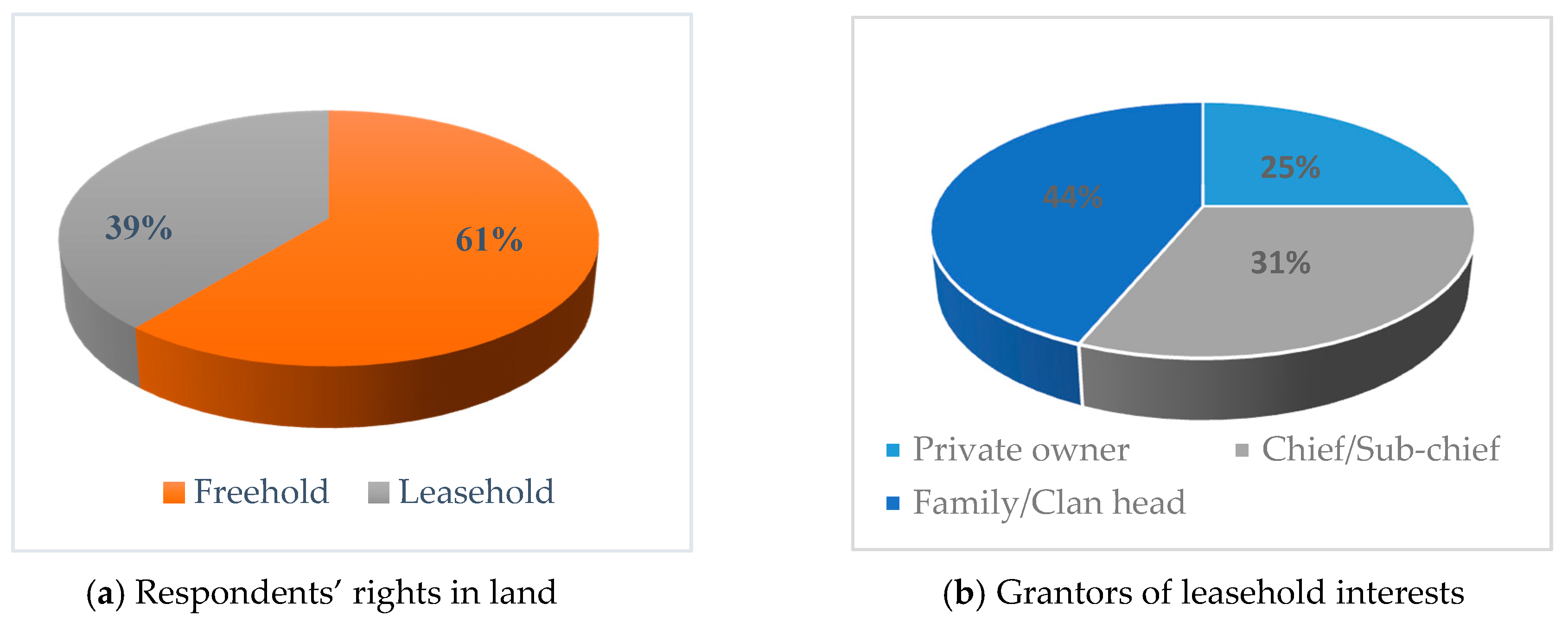
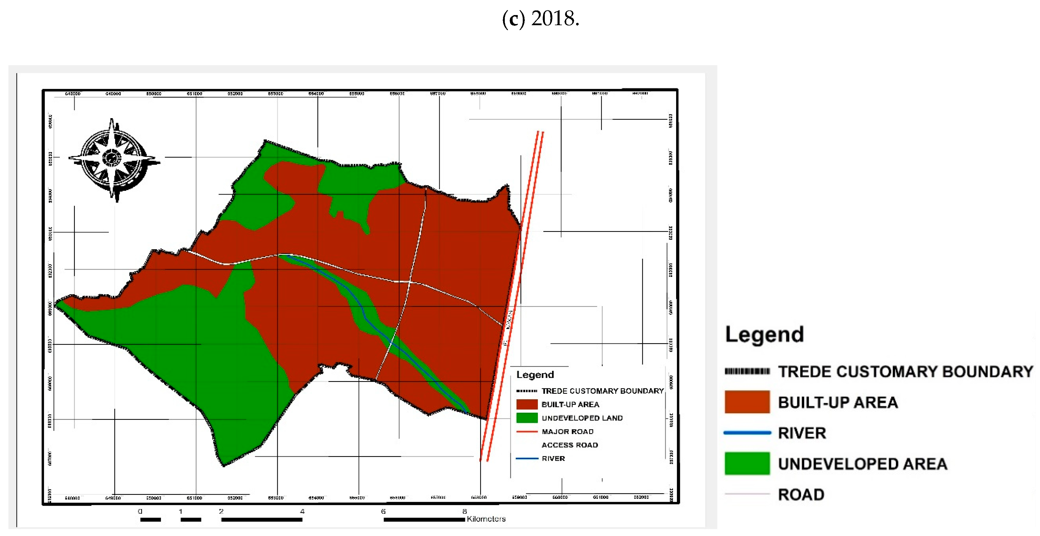
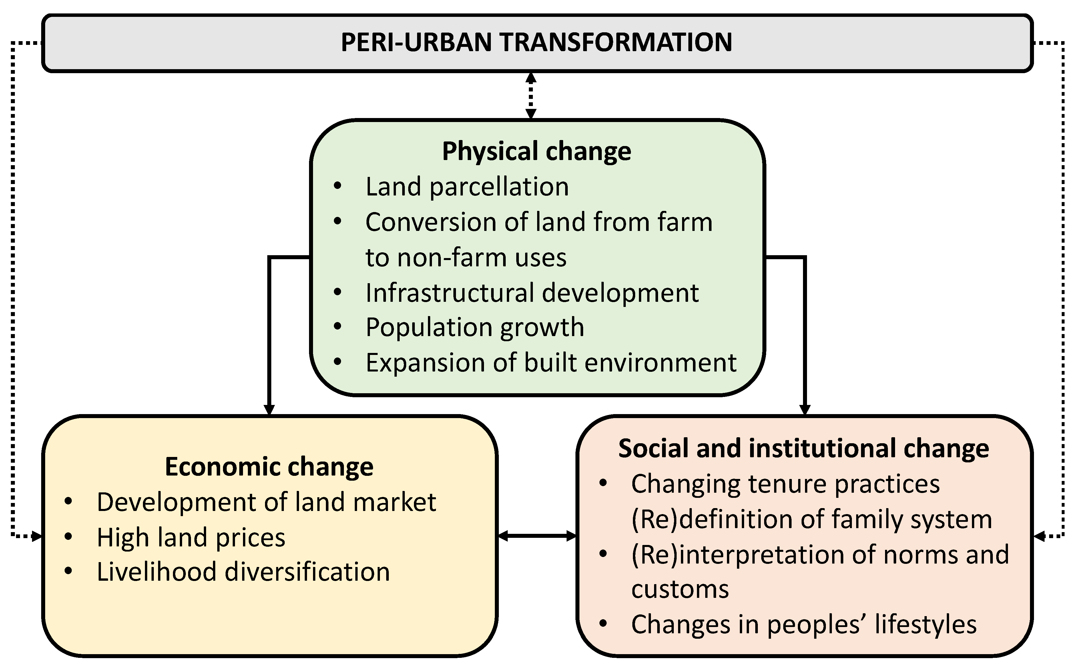
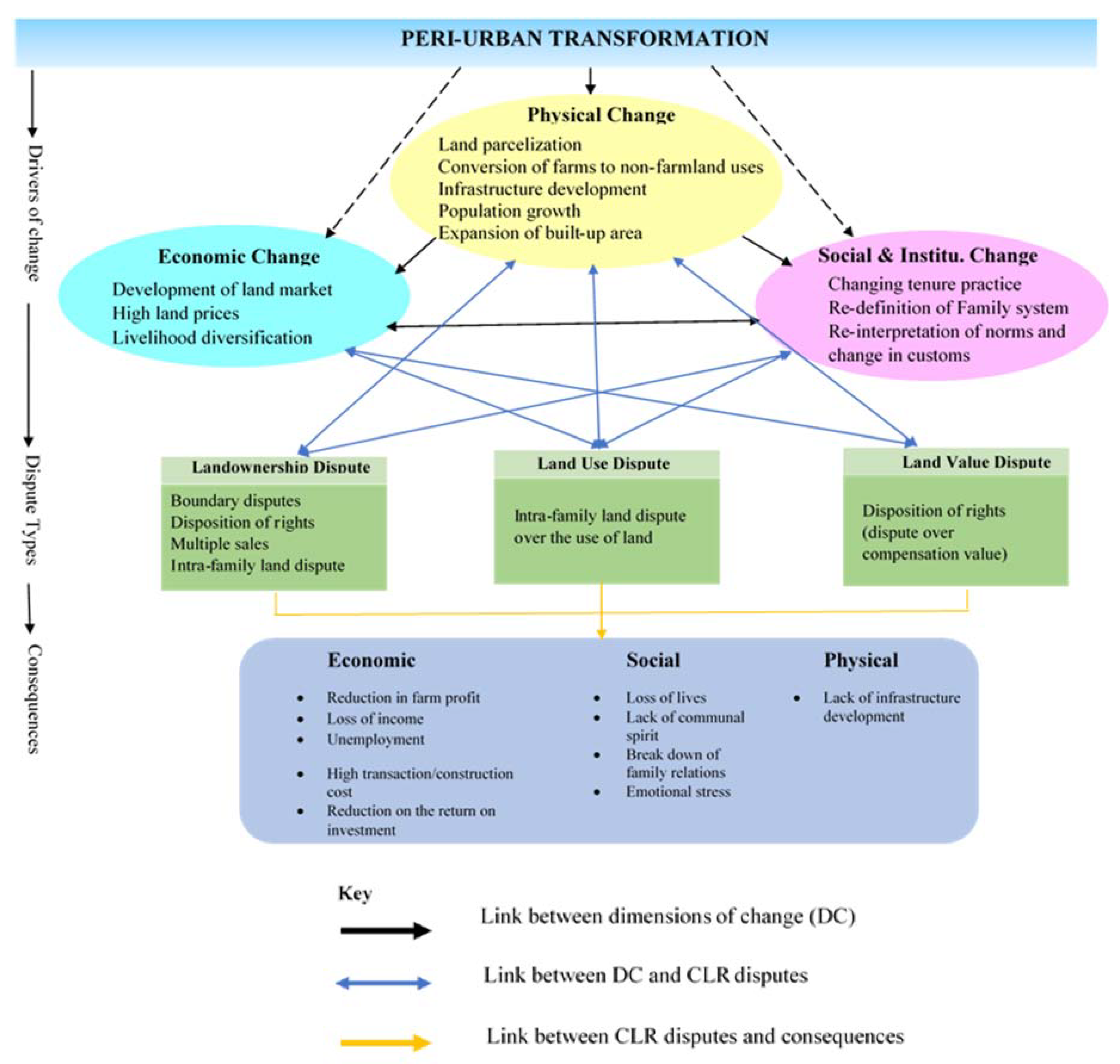
Table A1.
Overall research matrix (source: Authors, 2018).
| Research Variables | Information Required | Source of Data | Data Collection Method | Data Analysis Method |
|---|---|---|---|---|
| Transformation of Trede from rural to peri-urban town | History of Trede Past and future changes in development Changes in land tenure practices Factors influencing change Spatial maps visualizing changes in transformation process | Traditional leaders Landowners(natives) Government Officials Field observations | Key informant interviews Household survey Observations Governmental spatial data set review | Content and spatial analysis |
| Types of CLRs disputes | Land tenure arrangement in Trede Land ownership types Process of land acquisition Actors involved in disputes Common types of disputes in Trede Conflicting land ownership in Trede Description of the boundary disputes in Trede | Traditional Leaders and Family heads Landowners, developers, and users Government Officials Literature | Key informant interviews Household survey Observations Literature review | Descriptive statistics, content and spatial analysis |
| Causes of CLRs disputes | Changes in land tenure system Procedures of land acquisition Changes in land acquisition process Procedures for the sale of customary land Actors involved in disputes Actors interest and position in disputes Reasons for land disputes occurring | Traditional Leaders and Family heads Landowners, developers, and users Government Officials Literature | Key informant interviews Household survey Literature review | Descriptive statistics, content and narrative analysis |
Effects of CLRs disputes on peri-urban development | Effect of CLRs disputes on member’s livelihoods Effects on private investment Effects on physical development in the town Effects on economic development | Traditional Leaders and Family heads Landowners, developers, and users literature | Key informant interviews Household survey Literature review | Descriptive statistics, content and narrative analysis |
| Resolving CLRs disputes | Role of traditional leaders in dispute resolution Role of Government officials in disputes resolution Collaboration between Government officials and traditional leaders in dispute resolution Assessing the effectiveness of the customary court Existing mechanisms in resolving disputes in Trede Interventions needed in resolving land disputes | Traditional Leaders and Family heads Landowners, developers, and users Government Officials (land managers) Literature | Key informant interviews Household survey Observations Literature review | Descriptive statistics content and narrative analysis |
References
- Pradoto, W. Development Patterns and Socioeconomic Transformation in Peri-Urban Area.-The Case of Yogyakarta, Indonesia. Ph.D. Thesis, TU Berlin, Berlin, Germany, 10 February 2012. [Google Scholar] [CrossRef]
- Adam, A.G. Urbanization and the Struggle for Land in the Peri-Urban Areas of Ethiopia. In Proceedings of the Annual Bank Conference on Africa, Lusaka, Zambia, 23–27 May 2016. [Google Scholar]
- Global Land Tool Network (GLTN). Bridging the Gap on Land Governance and Tenure along the Urban-Rural Continuum; UN-Habitat/Global Land Tool Network: Nairobi, Kenya, 2018. [Google Scholar]
- Mends, T.M. Customary Land Tenure and Urbanization with a Case Study on the Peri-Urban Area of Accra, Ghana. Master’s Thesis, The Netherlands International Institute for Geo-information Science and Earth Observation Enschede, Enschede, The Netherlands, 2006. [Google Scholar]
- Chauveau, J.P.; Colin, J.P. Customary transfers and land sales in Côte d’Ivoire: Revisiting the embeddedness issue. Africa 2010, 80, 81–103. [Google Scholar] [CrossRef]
- Chauveau, J.P. Changes in Customary Land Tenure Systems in Africa; IIED: London, UK, 2007. [Google Scholar]
- Ubink, J.M. In the Land of the Chiefs: Customary Law, Land Conflicts, and the Role of the State in Peri-Urban Ghana; Leiden University Press Van Vollenhoven Institute, Faculty of Law, Leiden University: The Netherlands, 2008; p. 256. [Google Scholar]
- Kanji, N.; Cotula, L.; Hilhorst, T.; Toulmin, C.; Witten, W. Research Report 1 Can Land Registration Serve Poor and Marginalised Groups? International Institute for Environment and Development: London, UK, 2005. [Google Scholar]
- Alden Wily, L.; Hammond, D. Land Security and the Poor in Ghana. Is There a Way Forward? A Land Sector Scoping Study; DFID Ghana Rural Livelihoods Programme: Accra, Ghana, 2001. [Google Scholar]
- Amanor, K.S. Family values, land sales and agricultural commodification in South-Eastern Ghana. Afr. South East. Ghana Afr. 2010, 80, 104–125. [Google Scholar] [CrossRef]
- Wehrmann, B. Land Conflicts: A Practical Guide to Dealing with Land Disputes; Deutsche Gesellschaft für Technische Zusammenarbeit (GTZ) GmbH: Eschborn, Germany, 2008. [Google Scholar]
- Barry, M.; Danso, E.K. Tenure security, land registration and customary tenure in a peri-urban Accra community. Land Use Policy 2014, 39, 358–365. [Google Scholar] [CrossRef]
- Ubink, J.M. Negotiated or negated? The rhetoric and reality of customary tenure in an Ashanti village in Ghana. Africa 2008, 78, 264–287. [Google Scholar] [CrossRef]
- Akaateba, M.A. Urban Planning Practice under Neo-Customary Land Tenure: The Interface between Government Agencies and Traditional Authorities in Peri Urban Ghana. Ph.D. Thesis, TU Berlin, Berlin, Germany, 2008. [Google Scholar]
- Owusu, G. Indigenes’ and migrants’ access to land in peri-urban areas of Accra, Ghana. Int. Dev. Plan. Rev. 2008, 30, 177–198. [Google Scholar] [CrossRef]
- Peters, E. Contesting Land and Custom in Ghana. State, Chief and the Citizen. J. Agrar. Chang. 2010, 10, 604–608. [Google Scholar] [CrossRef]
- Kasanga, K.; Kotey, N.A. Land Management in Ghana: Building on Tradition and Modernity; UK’s Department for International Development (DFID): London, UK, 2001.
- Narain, V.; Nischal, S. The Peri-Urban Interface in Shahpur Khurd and Karnera, India. Environ. Urban. 2007, 19, 261–273. [Google Scholar]
- Kasanga, R.K.; Cochrane, J.A.; King, R.; Roth, M.J. Land markets and legal contradictions in the peri-urban area of Accra Ghana: Informant interviews and secondary data investigations. Res. Pap. 1996, 1–90. [Google Scholar] [CrossRef]
- Narain, V. Growing city, shrinking hinterland: Land acquisition, transition and conflict in peri-urban Gurgaon, India. Environ. Urban. 2009, 21, 501–512. [Google Scholar]
- Ravetz, J.; Fertner, C.; Nielsen, T.S. The Dynamics of Peri-urbanization. In Peri-Urban Futures: Scenarios and Models for Land Use Change in Europe; Routledge Publications: New York, NY, USA, 2013. [Google Scholar]
- Holland, M.D.; Kasanga, R.K.; Lewcock, C.P.; Warburton, H.J. Peri-urban Baseline Studies: Kumasi, Ashanti Region, Ghana; Vol. 1: Executive Summary and Main Report; Natural Resources Institute: Greenwich, UK, 1996; 86p. [Google Scholar]
- Iaquinta, D.L.; Drescher, A.W. Defining peri urban: Understanding rural-urban linkages and their connection to institutional contexts. In Proceedings of the Tenth World Congress of the International Rural Sociology Association, Rio de Janeiro, Brazil, 1 August 2000; Volume 1, pp. 3–28. [Google Scholar]
- Rakodi, C. Poverty in the Peri-urban Interface. Natural Resources Systems Programme (NRSP) Research Advances No. 5; DFID: London, UK, 1999.
- Piorr, A.; Ravets, J.; Tosics, I. (Eds.) Peri-urbanization in Europe. Towards European Policies to Sustain Urban-Rural Futures, Syntesis Report; Forest & Landscape: Frederiksberg, Denmark, 2011. [Google Scholar]
- Allen, A. Environmental planning and management of the peri-urban interface: Perspectives on an emerging field. Environ. Urban. 2003, 15, 135–148. [Google Scholar] [CrossRef]
- Nkwae, B. Conceptual Framework for Modelling and Analysing Periurban Land Problems in Southern Africa. Ph.D. Thesis, University of New Brunswick, Fredericton, NB, Canada, 2006. [Google Scholar]
- Charisa, I. Peri-urban Dynamics and Regional Planning in Africa: Implications for Building Healthy Cities. J. Agric. Ext. Rural Dev. 2010, 2, 15–26. [Google Scholar]
- Satterthwaite, D.; McGranahan, G.; Tacoli, C. Urbanisation and its implication for food and farming. R. Soc. Publ. 2010. [Google Scholar] [CrossRef]
- Kasanga, R.K. Land Tenure and the Development Dialogue: The Myth Concerning Communal Landholding in Ghana; Department of Land Economy, University of Cambridge: Cambridge, UK, 1988. [Google Scholar]
- FAO. Gender and Access to Land; FAO: Rome, Italy, 2002; Available online: http://www.fao.org/3/Y4308E/Y4308E00.htm (accessed on 15 February 2020).
- Dale, R. Development Planning: Concepts and Tools for Planners, Managers and Facilitators; Zed Books Limited: London, UK, 2004. [Google Scholar]
- Payne, G. Land tenure and property rights: An introduction. Habitat Int. 2004, 28, 167–179. [Google Scholar] [CrossRef]
- De Soto, H. The Mystery of Capital: Why Capitalism Triumphs in the West and Fails Everywhere Else; Civitas Books: New York, NY, USA, 2000. [Google Scholar]
- USAID. What is Land Tenure? 2014. Available online: https://www.usaid.gov/land-tenure (accessed on 15 February 2020).
- Hudalah, D.; de Roo, G. Transition: A Relevant Issue to Planning? Urban and Regional Studies Institute, University of Groningen: Groningen, The Netherlands, 2007. [Google Scholar]
- Ghana Statistical Service. Population of Atwima Kwanwoma District in Ghana; Atwima Kwanwoma District Assembly: Atwima Kwanwoma, Ghana, 2018. Available online: www.statsghana.gov.gh (accessed on 10 February 2020).
- Teddlie, C.; Tashakkori, A. Foundations of Mixed Methods Research: Integrating Quantitative and Qualitative Approaches in the Social and Behavioural Sciences; Sage: Beijing, China, 2009. [Google Scholar]
- Tacoli, C. Changing Rural-Urban Interactions in sub-Saharan Africa and their, Impacts on Livelihoods: A Summary. In Working Paper Series on Rural-Urban Interactions and Livelihood Strategies; Working Paper 7; IIED: London, UK, 2002. [Google Scholar]
- Rauws, W.S.; De Roo, G. Exploring transitions in the peri-urban area. Plan. Theory Pract. 2011, 12, 269–284. [Google Scholar] [CrossRef] [Green Version]
- Budiyantini, Y.; Pratiwi, V. Peri-urban typology of Bandung Metropolitan Area. Procedia Soc. Behav. Sci. 2016, 227, 833–837. [Google Scholar] [CrossRef] [Green Version]
- Crook, R.C.; Affou, S.; Hammond, D.; Vanga, A.F. The Law, Legal Institutions and the Protection of Land Rights in Ghana and Coˆte d’Ivoire: Developing a More Effective and Equitable System. In Final Report SSRU Project R 7993; Institute of Development Studies UK: Brighton, UK, 2005. [Google Scholar]
- Government of Ghana. Constitution of the Republic of Ghana; Assembly Press: Accra, Ghana, 1993. Available online: https://www.HomePage/republic/constitution.php?id=Gconst5.html (accessed on 10 February 2020).
- GIZ. Land Use Planning: Concept, Tools and Applications; GIZ: Eschborn, Germany, 2012. [Google Scholar]
- Chigbu, U.E.; Masum, F.; Leitmeier, A.; Antonio, D.; Mabikke, S.; Espinoza, E.; Hernig, A. Securing tenure through Land Use Planning: Conceptual framework, evidences and experiences from selected countries in Africa, Asia and Latin America. In Proceedings of the World Bank Conference on Land and Poverty, Washington, DC, USA, 23–27 March 2015. [Google Scholar]
- Chigbu, U.E.; Haub, O.; Mabikke, S.; Antonio, D.; Espinoza, J. Tenure Responsive Land Use Planning: A Guide for Country Level Implementation; UN-Habitat: Nairobi, Kenya, 2016; 92p. [Google Scholar]
- Bugri, J.T.; Yuonayel, E.M. Traditional Authorities and Peri-Urban Land Management in Ghana: Evidence from Wa. J. Resour. Dev. Manag. 2015, 13, 68–79. [Google Scholar]
- Chigbu, U.E. Anatomy of women’s landlessness in the patrilineal customary land tenure systems of sub-Saharan Africa and a policy pathway. Land Use Policy 2019, 86, 126–135. [Google Scholar] [CrossRef]
Figure 1.
Location of Trede in conurbation of Kumasi Metropolitan Area. Source: Authors.
Figure 2.
Respondents’ rights in land (a) and grantors’ leasehold interest (b) (source: Authors).

Figure 3.
Maps of built-up area of Trede between 1975–2018, (a) 1975, (b) 2000, and (c) 2018 (source: Authors (based on Geographic Information System Analysis).
Figure 3.
Maps of built-up area of Trede between 1975–2018, (a) 1975, (b) 2000, and (c) 2018 (source: Authors (based on Geographic Information System Analysis).
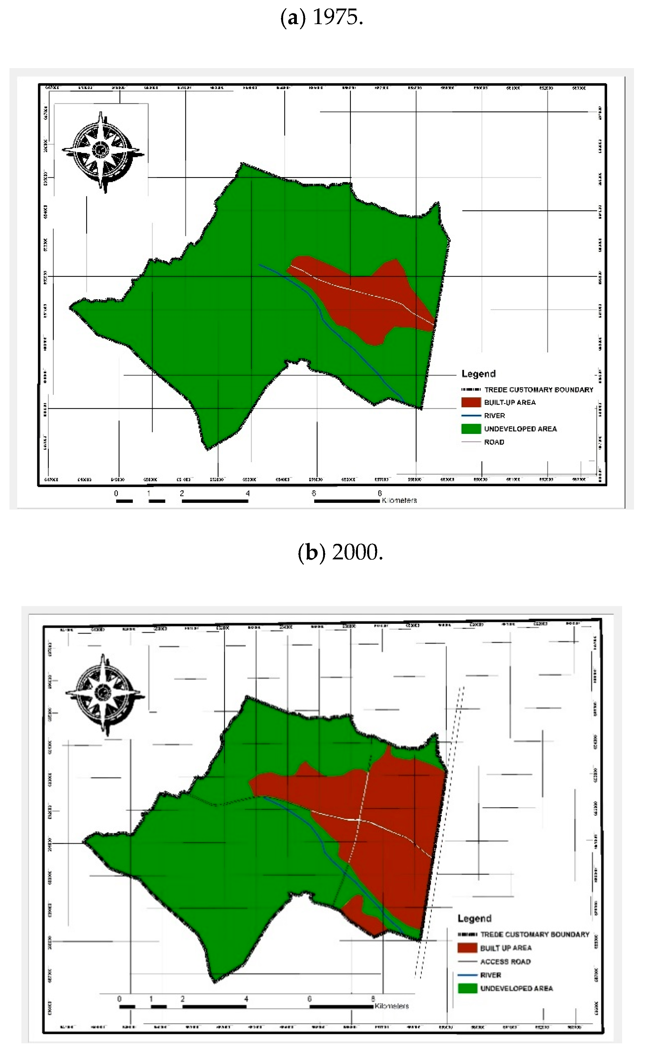

Figure 4.
Structural model of the interrelated transformation process of Trede (source: Authors).

Figure 5.
Types of customary land rights disputes in Trede (source: Field survey, 2018).
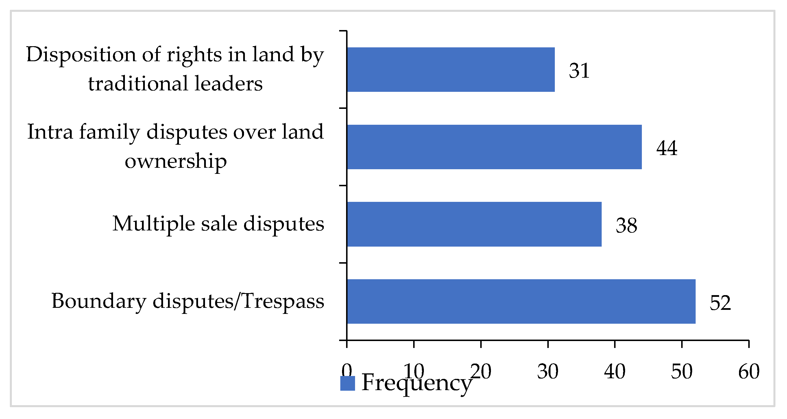
Figure 6.
Linkages between peri-urban transformation, customary land rights (CLRs) disputes and their effects on peri-urban development (source: Authors).
Figure 6.
Linkages between peri-urban transformation, customary land rights (CLRs) disputes and their effects on peri-urban development (source: Authors).

Figure 7.
Land disputes resolution mechanism employed by disputants (source: Field survey, 2018).
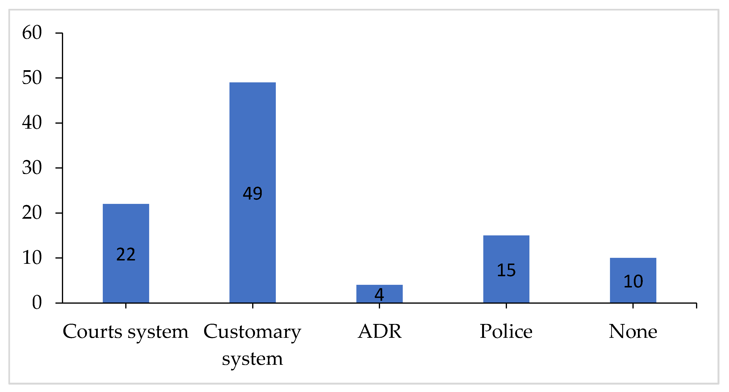
Table 1.
Mode of acquisition of land by age of respondent.
| Age | How Did You Acquire the Land? | Total | |||||
|---|---|---|---|---|---|---|---|
| Inheritance | Purchase | Gift | Rent | ||||
| Under 30 years | Count (%) | 4 (36) | 5 (46) | 2 (18) | 0 (0) | 11 (100) | |
| Between 30–60 years | Count (%) | 16 (39) | 21 (51) | 2 (5) | 2 (5) | 41 (100) | |
| Over 60 years | Count (%) | 21 (70) | 3 (10) | 6 (20) | 0 (0) | 30 (100) | |
| TOTAL | Count (%) | 41 (50) | 29 (35.4) | 10 (12.2) | 2 (2.4) | 82 (100) | |
Source: Field survey, 2018.
Table 2.
Primary occupation of respondents.
| Occupation | No. of Responses (N = 165) | Percent (N = 100%) |
|---|---|---|
| Farming | 65 | 31 |
| Trading | 31 | 19 |
| Civil Service | 6 | 4 |
| Artisan | 42 | 25 |
| Student | 4 | 2 |
| Driver | 5 | 3 |
| None | 12 | 8 |
Source: Authors.
Table 3.
Proportion of undeveloped and developed land in Trede (source: Field survey, 2018).
| Land Use | 1975 Area (acres) | % | 2000 Area (acres) | % | % Change | 2018 Area (acres) | % | % Change |
|---|---|---|---|---|---|---|---|---|
| Developed | 145.30 | 11.75 | 379.45 | 30.70 | 19.00 | 782.09 | 63.60 | 32.9 |
| Undeveloped | 1091.61 | 88.26 | 856.47 | 69.30 | 18.96 | 447.71 | 36.41 | –32.9 |
© 2020 by the authors. Licensee MDPI, Basel, Switzerland. This article is an open access article distributed under the terms and conditions of the Creative Commons Attribution (CC BY) license (http://creativecommons.org/licenses/by/4.0/).
Share and Cite
MDPI and ACS Style
Owusu Ansah, B.; Chigbu, U.E. The Nexus between Peri-Urban Transformation and Customary Land Rights Disputes: Effects on Peri-Urban Development in Trede, Ghana. Land 2020, 9, 187. https://doi.org/10.3390/land9060187
AMA Style
Owusu Ansah B, Chigbu UE. The Nexus between Peri-Urban Transformation and Customary Land Rights Disputes: Effects on Peri-Urban Development in Trede, Ghana. Land. 2020; 9(6):187. https://doi.org/10.3390/land9060187
Chicago/Turabian StyleOwusu Ansah, Barikisa, and Uchendu Eugene Chigbu. 2020. "The Nexus between Peri-Urban Transformation and Customary Land Rights Disputes: Effects on Peri-Urban Development in Trede, Ghana" Land 9, no. 6: 187. https://doi.org/10.3390/land9060187
Note that from the first issue of 2016, this journal uses article numbers instead of page numbers. See further details here.