Exploring the Dynamics of Urban Greenness Space and Their Driving Factors Using Geographically Weighted Regression: A Case Study in Wuhan Metropolis, China
Abstract
1. Introduction
2. Study Area, Data Sources, and Methodology
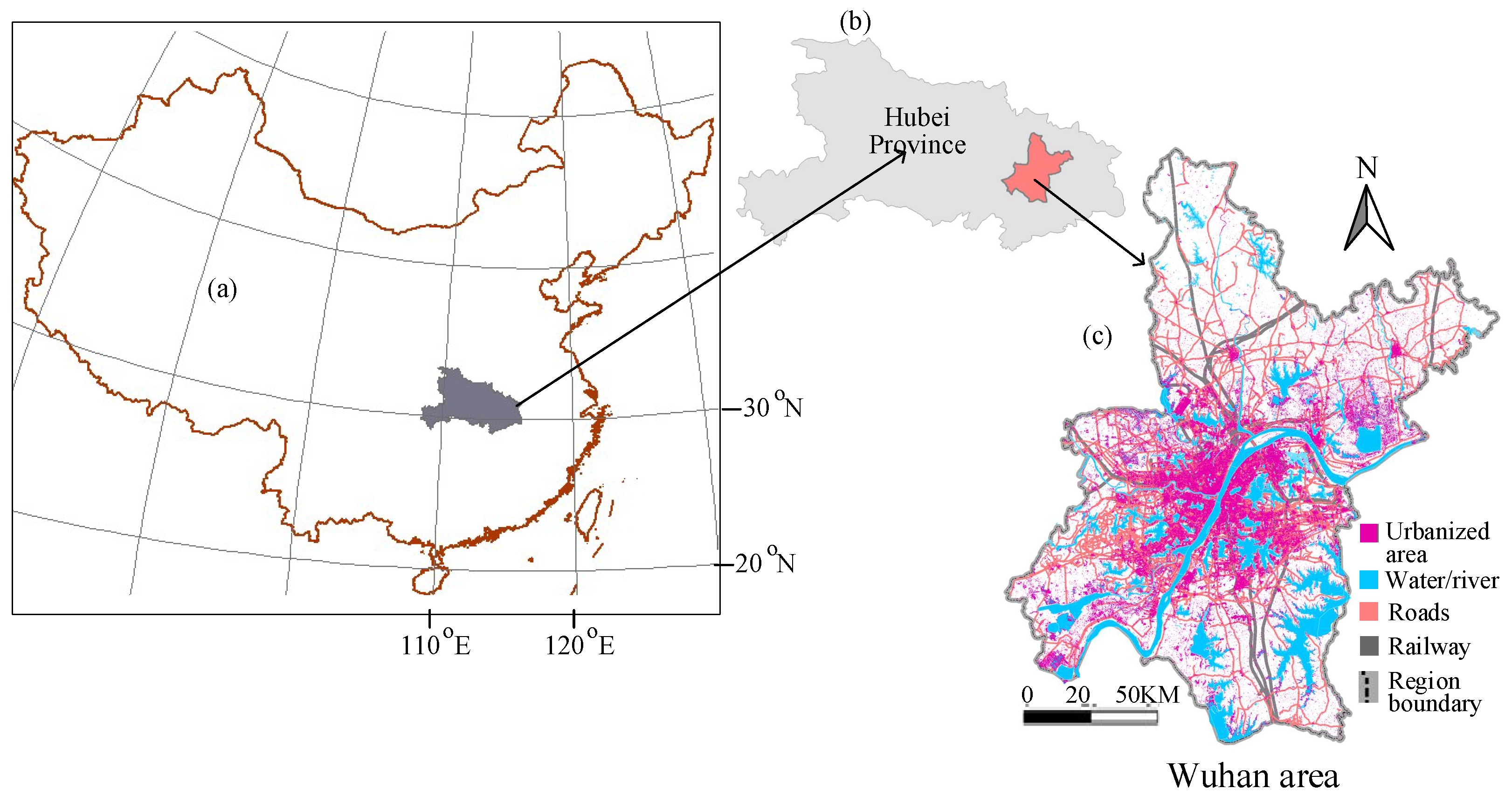
2.1. Study Area
2.2. Data Sources
2.3. Methods
3. Results
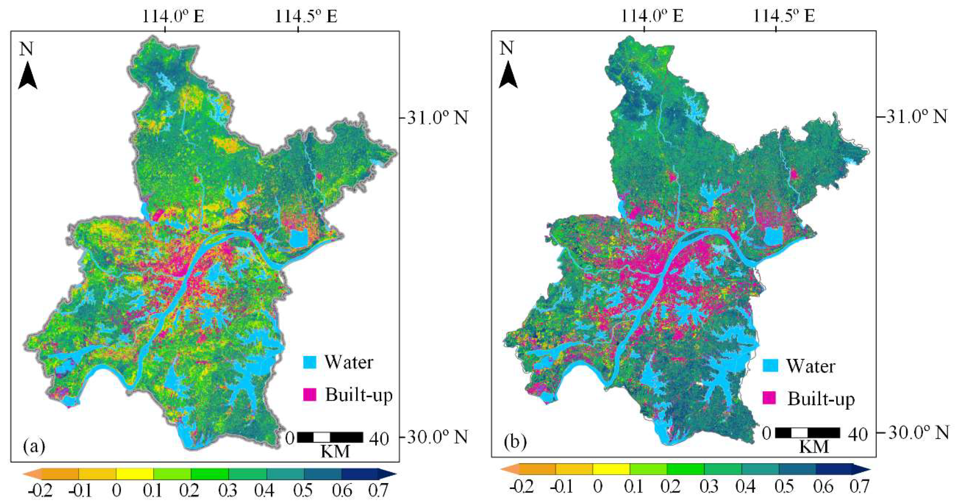
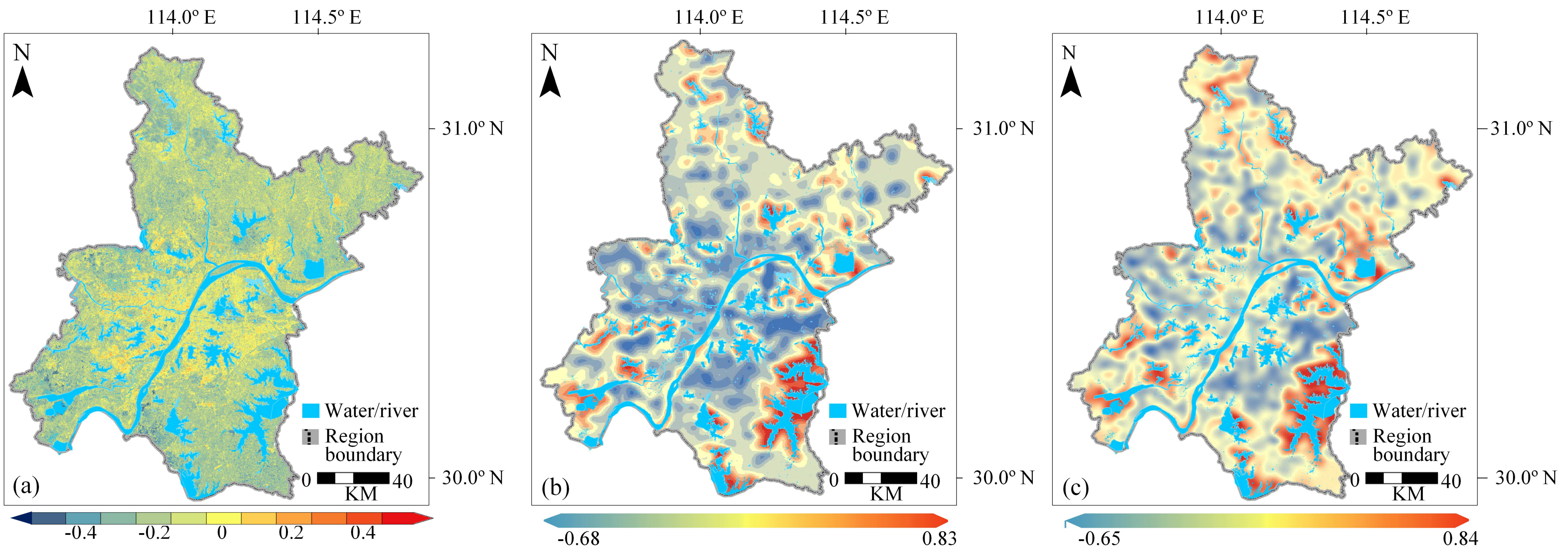
3.1. Temporal Dynamics of Urban Greenness
3.2. Factor Analysis for the Dynamics of the Urban Greenness
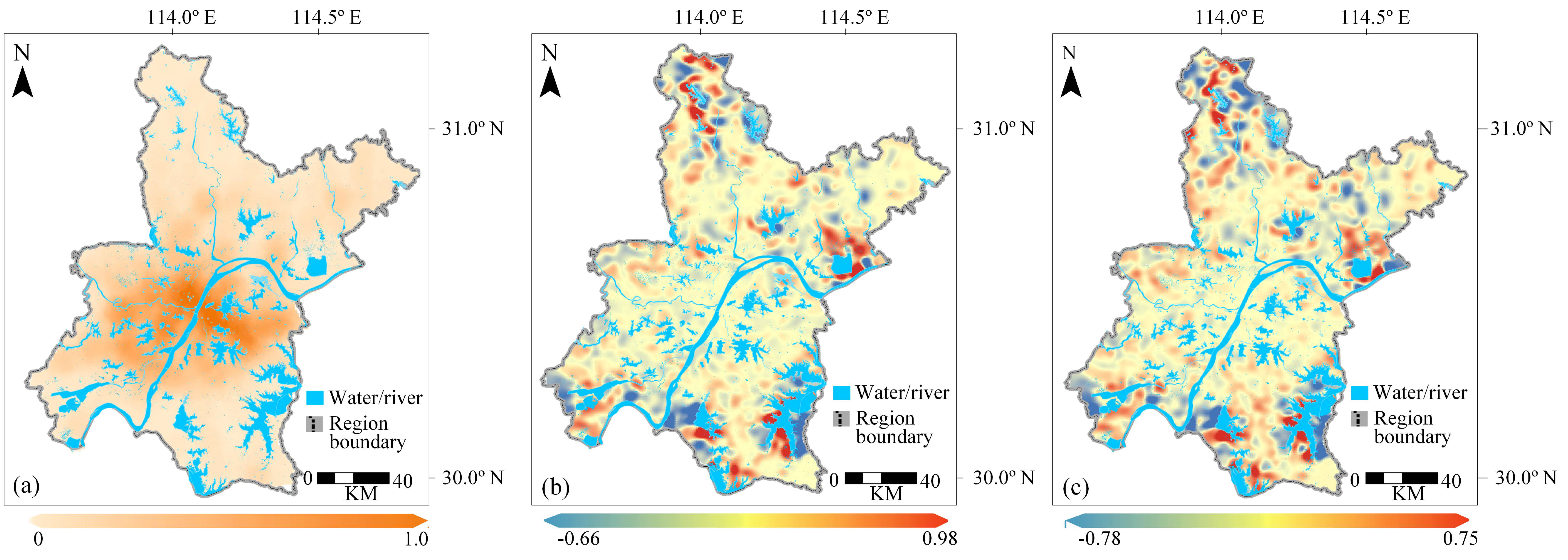
3.3. Analysis of Driving Factors on Urban Greenness Landscape Based on GWR
4. Discussions
5. Conclusions
Author Contributions
Funding
Conflicts of Interest
References
- Crouse, D.L.; Pinault, L.; Balram, A.; Hystad, P.; Peters, P.A.; Chen, H.; van Donkelaar, A.; Martin, R.V.; Ménard, R.; Robichaud, A.; et al. Urban greenness and mortality in Canada’s largest cities: A national cohort study. Lancet Planet. Health 2017, 1, e289–e297. [Google Scholar] [CrossRef]
- United Nations, Department of Economic and Social Affairs, Population Division. World Urbanization Prospects: The 2018 Revision (ST/ESA/SER.A/420); United Nations: New York, NY, USA, 2019. [Google Scholar]
- Yang, G.; Zhao, Y.; Xing, H.; Fu, Y.; Liu, G.; Kang, X.; Mai, X. Understanding the changes in spatial fairness of urban greenery using time-series remote sensing images: A case study of Guangdong-Hong Kong-Macao Greater Bay. Sci. Total Environ. 2020, 715, 136763. [Google Scholar] [CrossRef] [PubMed]
- Follmann, A.; Hartmann, G.; Dannenberg, P. Multi-temporal transect analysis of peri-urban developments in Faridabad, India. J. Maps 2018, 14, 17–25. [Google Scholar] [CrossRef]
- Tian, G.; Qiao, Z. Assessing the impact of the urbanization process on net primary productivity in China in 1989–2000. Environ. Pollut. 2014, 184, 320–326. [Google Scholar] [CrossRef] [PubMed]
- Buyantuyev, A.; Wu, J. Urbanization diversifies land surface phenology in arid environments: Interactions among vegetation, climatic variation, and land use pattern in the Phoenix metropolitan region, USA. Landsc. Urban Plan. 2012, 105, 149–159. [Google Scholar] [CrossRef]
- Huang, C.; Yang, J.; Lu, H.; Huang, H.; Yu, L. Green Spaces as an Indicator of Urban Health: Evaluating Its Changes in 28 Mega-Cities. Remote Sens. 2017, 9, 1266. [Google Scholar] [CrossRef]
- Cârlan, I.; Mihai, B.A.; Nistor, C.; Große-Stoltenberg, A. Identifying urban vegetation stress factors based on open access remote sensing imagery and field observations. Ecol. Inform. 2020, 55, 101032. [Google Scholar] [CrossRef]
- Liu, Y.; Wang, R.; Grekousis, G.; Liu, Y.; Yuan, Y.; Li, Z. Neighbourhood greenness and mental wellbeing in Guangzhou, China: What are the pathways? Landsc. Urban Plan. 2019, 190, 103602. [Google Scholar] [CrossRef]
- Dennis, M.; Barlow, D.; Cavan, G.; Cook, P.; Gilchrist, A.; Handley, J.; James, P.; Thompson, J.; Tzoulas, K.; Wheater, C.P.; et al. Mapping Urban Green Infrastructure: A Novel Landscape-Based Approach to Incorporating Land Use and Land Cover in the Mapping of Human-Dominated Systems. Land 2018, 7, 17. [Google Scholar] [CrossRef]
- Wu, W.; Wang, M.; Zhu, N.; Zhang, W.; Sun, H. Residential satisfaction about urban greenness: Heterogeneous effects across social and spatial gradients. Urban For. Urban Green. 2019, 38, 133–144. [Google Scholar] [CrossRef]
- Sulander, T.; Karvinen, E.; Holopainen, M. Urban Green Space Visits and Mortality Among Older Adults. Epidemiology 2016, 27, e34–e35. [Google Scholar] [CrossRef] [PubMed]
- Hussein, S.O. Monitoring urban greenness evolution using multitemporal Landsat imagery in the city of Erbil (Iraq). Cent. Eur. Geol. 2019, 62, 15–26. [Google Scholar] [CrossRef]
- Zhong, Q.; Ma, J.; Zhao, B.; Wang, X.; Zong, J.; Xiao, X. Assessing spatial-temporal dynamics of urban expansion, vegetation greenness and photosynthesis in megacity Shanghai, China during 2000–2016. Remote Sens. Environ. 2019, 233, 111374. [Google Scholar] [CrossRef]
- Lu, L.; Weng, Q.; Guo, H.; Feng, S.; Li, Q. Assessment of urban environmental change using multi-source remote sensing time series (2000–2016): A comparative analysis in selected megacities in Eurasia. Sci. Total Environ. 2019, 684, 567–577. [Google Scholar] [CrossRef] [PubMed]
- Chen, B.; Nie, Z.; Chen, Z.; Xu, B. Quantitative estimation of 21st-century urban greenspace changes in Chinese populous cities. Sci. Total Environ. 2017, 609, 956–965. [Google Scholar] [CrossRef] [PubMed]
- Franco, S.F.; Macdonald, J.L. Measurement and valuation of urban greenness: Remote sensing and hedonic applications to Lisbon, Portugal. Reg. Sci. Urban Econ. 2018, 72, 156–180. [Google Scholar] [CrossRef]
- Drummond, M.A.; Stier, M.P.; Diffendorfer, J.; Jay, E. Historical land use and land cover for assessing the northern Colorado Front Range urban landscape. J. Maps 2019, 15, 89–93. [Google Scholar] [CrossRef]
- Sha, Z.; Ali, Y.; Wang, Y.; Chen, J.; Tan, X.; Li, R. Mapping the changes in urban greenness based on localized spatial association analysis under temporal context using MODIS data. ISPRS Int. J. Geo-Inform. 2018, 7, 407. [Google Scholar] [CrossRef]
- Miller, D.L.; Alonzo, M.; Roberts, D.A.; Tague, C.L.; McFadden, J.P. Drought response of urban trees and turfgrass using airborne imaging spectroscopy. Remote Sens. Environ. 2020, 240, 111646. [Google Scholar] [CrossRef]
- El Garouani, A.; Mulla, D.J.; El Garouani, S.; Knight, J. Analysis of urban growth and sprawl from remote sensing data: Case of Fez, Morocco. Int. J. Sustain. Built Environ. 2017, 6, 160–169. [Google Scholar] [CrossRef]
- Rimal, B.; Zhang, L.; Stork, N.; Sloan, S.; Rijal, S. Urban expansion occurred at the expense of agricultural lands in the Tarai region of Nepal from 1989 to 2016. Sustainability 2018, 10, 1341. [Google Scholar] [CrossRef]
- Fan, C.; Johnston, M.; Darling, L.; Scott, L.; Liao, F.H. Land use and socio-economic determinants of urban forest structure and diversity. Landsc. Urban Plan. 2019, 181, 10–21. [Google Scholar] [CrossRef]
- Güneralp, B.; Seto, K.C.; Ramachandran, M. Evidence of urban land teleconnections and impacts on hinterlands. Curr. Opin. Environ. Sustain. 2013, 5, 445–451. [Google Scholar] [CrossRef]
- Rimal, B.; Zhang, L.; Keshtkar, H.; Sun, X.; Rijal, S. Quantifying the spatiotemporal pattern of urban expansion and hazard and risk area identification in the Kaski District of Nepal. Land 2018, 7, 37. [Google Scholar] [CrossRef]
- Cui, Y.; Cheng, D.; Choi, C.E.; Jin, W.; Lei, Y.; Kargel, J.S. The cost of rapid and haphazard urbanization: Lessons learned from the Freetown landslide disaster. Landslides 2019, 1167–1176. [Google Scholar] [CrossRef]
- Wang, J.; Zhou, W.; Qian, Y.; Li, W.; Han, L. Quantifying and characterizing the dynamics of urban greenspace at the patch level: A new approach using object-based image analysis. Remote Sens. Environ. 2018, 204, 94–108. [Google Scholar] [CrossRef]
- Xie, Y.; Sha, Z.; Yu, M. Remote sensing imagery in vegetation mapping: A review. J. Plant Ecol. 2008, 1, 9–23. [Google Scholar] [CrossRef]
- Zhu, Z.; Fu, Y.; Woodcock, C.E.; Olofsson, P.; Vogelmann, J.E.; Holden, C.; Wang, M.; Dai, S.; Yu, Y. Including land cover change in analysis of greenness trends using all available Landsat 5, 7, and 8 images: A case study from Guangzhou, China (2000–2014). Remote Sens. Environ. 2016, 185, 243–257. [Google Scholar] [CrossRef]
- Kabisch, N.; Selsam, P.; Kirsten, T.; Lausch, A.; Bumberger, J. A multi-sensor and multi-temporal remote sensing approach to detect land cover change dynamics in heterogeneous urban landscapes. Ecol. Indic. 2019, 99, 273–282. [Google Scholar] [CrossRef]
- Dou, Y.; Kuang, W. A comparative analysis of urban impervious surface and green space and their dynamics among 318 different size cities in China in the past 25 years. Sci. Total Environ. 2020, 706, 135828. [Google Scholar] [CrossRef]
- Wang, W.; Lin, Z.; Zhang, L.; Yu, T.; Ciren, P.; Zhu, Y. Building visual green index: A measure of visual green spaces for urban building. Urban For. Urban Green. 2019, 40, 335–343. [Google Scholar] [CrossRef]
- Threlfall, C.G.; Ossola, A.; Hahs, A.K.; Williams, N.S.G.; Wilson, L.; Livesley, S.J. Variation in Vegetation Structure and Composition across Urban Green Space Types. Front. Ecol. Evol. 2016, 4, 66. [Google Scholar] [CrossRef]
- Harms, T.M.; Murphy, K.T.; Lyu, X.; Patterson, S.S.; Kinkead, K.E.; Dinsmore, S.J.; Frese, P.W. Using landscape habitat associations to prioritize areas of conservation action for terrestrial birds. PLoS ONE 2017, 12, e0173041. [Google Scholar] [CrossRef] [PubMed]
- Hamad, R.; Kolo, K.; Balzter, H. Post-War Land Cover Changes and Fragmentation in Halgurd Sakran National Park (HSNP), Kurdistan Region of Iraq. Land 2018, 7, 38. [Google Scholar] [CrossRef]
- Kowe, P.; Mutanga, O.; Odindi, J.; Dube, T. A quantitative framework for analysing long term spatial clustering and vegetation fragmentation in an urban landscape using multi-temporal landsat data. Int. J. Appl. Earth Obs. Geoinf. 2020, 88, 102057. [Google Scholar] [CrossRef]
- He, H.S.; DeZonia, B.E.; Mladenoff, D.J. An aggregation index (AI) to quantify spatial patterns of landscapes. Landsc. Ecol. 2000, 15, 591–601. [Google Scholar] [CrossRef]
- Wang, Y.; Sha, Z.; Tan, X.; Lan, H.; Liu, X.; Rao, J. Modeling urban growth by coupling localized spatio-temporal association analysis and binary logistic regression. Comput. Environ. Urban Syst. 2020, 81, 101482. [Google Scholar] [CrossRef]
- He, Q.; Tan, R.; Gao, Y.; Zhang, M.; Xie, P.; Liu, Y. Modeling urban growth boundary based on the evaluation of the extension potential: A case study of Wuhan city in China. Habitat Int. 2018, 72, 57–65. [Google Scholar] [CrossRef]
- Khan, Y.A.; Wang, Y.; Sha, Z. Land Cover Change Analysis in Wuhan, China Using Google Earth Engine Platform and Ancillary Knowledge. In Communications in Computer and Information Science; Springer: Berlin, Germany, 2019; Volume 980, pp. 229–239. [Google Scholar]
- Gorelick, N.; Hancher, M.; Dixon, M.; Ilyushchenko, S.; Thau, D.; Moore, R. Google Earth Engine: Planetary-scale geospatial analysis for everyone. Remote Sens. Environ. 2017, 202, 18–27. [Google Scholar] [CrossRef]
- Lamchin, M.; Lee, W.K.; Jeon, S.W.; Wang, S.W.; Lim, C.H.; Song, C.; Sung, M. Long-term trend and correlation between vegetation greenness and climate variables in Asia based on satellite data. Sci. Total Environ. 2018, 618, 1089–1095. [Google Scholar] [CrossRef]
- Price, D.T.; McKenney, D.W.; Nalder, I.A.; Hutchinson, M.F.; Kesteven, J.L. A comparison of two statistical methods for spatial interpolation of Canadian monthly mean climate data. Agric. For. Meteorol. 2000, 101, 81–94. [Google Scholar] [CrossRef]
- Li, X.; Zhang, Y.; Jin, X.; He, Q.; Zhang, X. Comparison of digital elevation models and relevant derived attributes. J. Appl. Remote Sens. 2017, 11, 1. [Google Scholar] [CrossRef]
- Wang, Y.; Xue, Z.; Chen, J.; Chen, G. Spatio-temporal analysis of phenology in Yangtze River Delta based on MODIS NDVI time series from 2001 to 2015. Front. Earth Sci. 2019, 13, 92–110. [Google Scholar] [CrossRef]
- Patela, N.N.; Angiuli, E.; Gamba, P.; Gaughan, A.; Lisini, G.; Stevens, F.R.; Tatem, A.J.; Trianni, G. Multitemporal settlement and population mapping from landsatusing google earth engine. Int. J. Appl. Earth Obs. Geoinf. 2015, 35, 199–208. [Google Scholar] [CrossRef]
- Dong, J.; Xiao, X.; Menarguez, M.A.; Zhang, G.; Qin, Y.; Thau, D.; Biradar, C.; Moore, B. Mapping paddy rice planting area in northeastern Asia with Landsat 8 images, phenology-based algorithm and Google Earth Engine. Remote Sens. Environ. 2016, 185, 142–154. [Google Scholar] [CrossRef]
- Chen, J.; Zhu, X.; Vogelmann, J.E.; Gao, F.; Jin, S. A simple and effective method for filling gaps in Landsat ETM+ SLC-off images. Remote Sens. Environ. 2011, 115, 1053–1064. [Google Scholar] [CrossRef]
- Asare, Y.M.; Forkuo, E.K.; Forkuor, G.; Thiel, M. Evaluation of gap-filling methods for Landsat 7 ETM+ SLC-off image for LULC classification in a heterogeneous landscape of West Africa. Int. J. Remote Sens. 2020, 41, 2544–2564. [Google Scholar] [CrossRef]
- Huang, H.; Chen, Y.; Clinton, N.; Wang, J.; Wang, X.; Liu, C.; Gong, P.; Yang, J.; Bai, Y.; Zheng, Y.; et al. Mapping major land cover dynamics in Beijing using all Landsat images in Google Earth Engine. Remote Sens. Environ. 2017, 202, 166–176. [Google Scholar] [CrossRef]
- Zhang, D.D.; Zhang, L. Land cover change in the central region of the lower yangtze river based on landsat imagery and the google earth engine: A case study in Nanjing, China. Sensors 2020, 20, 2091. [Google Scholar] [CrossRef]
- Pan, X.; Zhu, X.; Yang, Y.; Cao, C.; Zhang, X.; Shan, L. Applicability of Downscaling Land Surface Temperature by Using Normalized Difference Sand Index. Sci. Rep. 2018, 8, 1–14. [Google Scholar] [CrossRef]
- Bhatti, S.S.; Tripathi, N.K. Built-up area extraction using Landsat 8 OLI imagery. GISci. Remote Sens. 2014, 51, 445–467. [Google Scholar] [CrossRef]
- Delgadillo Herrera, M.; Arreola Esquivel, M.M.; Toxqui-Quitl, C.; Padilla-Vivanco, A. Normalized difference indices in Landsat 5 TM satellite data. In Proceedings of the Current Developments in Lens Design and Optical Engineering XX; Johnson, R.B., Mahajan, V.N., Thibault, S., Eds.; SPIE: Bellingham, DC, USA, 2019; Volume 11104, p. 35. [Google Scholar]
- Wang, J.; Wang, K.; Zhang, M.; Zhang, C. Impacts of climate change and human activities on vegetation cover in hilly southern China. Ecol. Eng. 2015, 81, 451–461. [Google Scholar] [CrossRef]
- Han, J.C.; Huang, Y.; Zhang, H.; Wu, X. Characterization of elevation and land cover dependent trends of NDVI variations in the Hexi region, northwest China. J. Environ. Manag. 2019, 232, 1037–1048. [Google Scholar] [CrossRef]
- Gocic, M.; Trajkovic, S. Analysis of changes in meteorological variables using Mann-Kendall and Sen’s slope estimator statistical tests in Serbia. Glob. Planet. Chang. 2013, 100, 172–182. [Google Scholar] [CrossRef]
- Liu, B.; Bi, X.; Zhang, J.; Yuan, J.; Xiao, Z.; Dai, Q.; Feng, Y.; Zhang, Y. Insight into the critical factors determining the particle number concentrations during summer at a megacity in China. J. Environ. Sci. 2019, 75, 169–180. [Google Scholar] [CrossRef] [PubMed]
- Cong, N.; Shen, M.; Yang, W.; Yang, Z.; Zhang, G.; Piao, S. Varying responses of vegetation activity to climate changes on the Tibetan Plateau grassland. Int. J. Biometeorol. 2017, 61, 1433–1444. [Google Scholar] [CrossRef] [PubMed]
- Brunsdon, C.; Fotheringham, S.; Charlton, M. Geographically Weighted Regression. J. R. Stat. Soc. Ser. D Stat. 1998, 47, 431–443. [Google Scholar] [CrossRef]
- Özbay, N.; Toker, S. Multicollinearity in simultaneous equations system: Evaluation of estimation performance of two-parameter estimator. Comput. Appl. Math. 2018, 37, 5334–5357. [Google Scholar] [CrossRef]
- Tamura, R.; Kobayashi, K.; Takano, Y.; Miyashiro, R.; Nakata, K.; Matsui, T. Mixed integer quadratic optimization formulations for eliminating multicollinearity based on variance inflation factor. J. Glob. Optim. 2019, 73, 431–446. [Google Scholar] [CrossRef]
- Wang, Q.; Xiao, Q.; Liu, C.; Wang, K.; Ye, M.; Lei, A.; Song, X.; Kohata, K. Effect of reforestation on nitrogen and phosphorus dynamics in the catchment ecosystems of subtropical China: The example of the Hanjiang River basin. J. Sci. Food Agric. 2012, 92, 1119–1129. [Google Scholar] [CrossRef]
- Zhang, Y.; Feng, R.; Wu, R.; Zhong, P.; Tan, X.; Wu, K.; Ma, L. Global climate change: Impact of heat waves under different definitions on daily mortality in Wuhan, China. Glob. Health Res. Policy 2017, 2, 10. [Google Scholar] [CrossRef] [PubMed]
- Roy, D.P.; Kovalskyy, V.; Zhang, H.K.; Vermote, E.F.; Yan, L.; Kumar, S.S.; Egorov, A. Characterization of Landsat-7 to Landsat-8 reflective wavelength and normalized difference vegetation index continuity. Remote Sens. Environ. 2016, 185, 57–70. [Google Scholar] [CrossRef] [PubMed]
- Shi, L.; Ling, F.; Foody, G.M.; Chen, C.; Fang, S.; Li, X.; Zhang, Y.; Du, Y. Permanent disappearance and seasonal fluctuation of urban lake area in Wuhan, China monitored with long time series remotely sensed images from 1987 to 2016. Int. J. Remote Sens. 2019, 40, 8484–8505. [Google Scholar] [CrossRef]
- Paolini, L.; Schwendenmann, L.; Aráoz, E.; Powell, P.A. Decoupling of the urban vegetation productivity from climate. Urban For. Urban Green. 2019, 44, 126428. [Google Scholar] [CrossRef]
- Dong, Y.; Liu, H.; Zheng, T. Does the connectivity of urban public green space promote its use? An empirical study of Wuhan. Int. J. Environ. Res. Public Health 2020, 17, 297. [Google Scholar] [CrossRef] [PubMed]
- Reygadas, Y.; Jensen, J.L.R.; Moisen, G.G.; Currit, N.; Chow, E.T. Assessing the relationship between vegetation greenness and surface temperature through Granger causality and Impulse-Response coefficients: A case study in Mexico. Int. J. Remote Sens. 2020, 41, 3761–3783. [Google Scholar] [CrossRef]
- Wang, H.F.; Qureshi, S.; Qureshi, B.A.; Qiu, J.X.; Friedman, C.R.; Breuste, J.; Wang, X.K. A multivariate analysis integrating ecological, socioeconomic and physical characteristics to investigate urban forest cover and plant diversity in Beijing, China. Ecol. Indic. 2016, 60, 921–929. [Google Scholar] [CrossRef]


| ID | Type | Period | Category | Variable | Data Source |
|---|---|---|---|---|---|
| 1 | Explanatory | Latest | Human activities | Road network | Local transportation bureau |
| 2 | Explanatory | Latest | Human activities | Railways | Local transportation bureau |
| 3 | Explanatory | 2000–2018 | Human activities | Rivers | Google Earth Engine |
| 4 | Explanatory | 2000–2018 | Human activities | NDBI | Google Earth Engine |
| 5 | Explanatory | 2000–2018 | Climate | Precipitation | China’s meteorological data sharing platform |
| 6 | Explanatory | 2000–2018 | Climate | Temperature | China’s meteorological data sharing platform |
| 7 | Explanatory | One time | Topography | DEM | Google Earth Engine |
| 8 | Explanatory | One time | Topography | Slope | Google Earth Engine |
| 9 | Dependent | 2000–2018 | Urban greenness | PLAND, AI | Google Earth Engine |
| Variable | Linear Slope | Sen’s Slope | Kendall (τ) | p Value |
|---|---|---|---|---|
| PLAND | −0.009 | −0.010 | −0.712 | <0.01 * |
| AI | −0.011 | −0.011 | −0.906 | <0.01 * |
| NDVI | 0.103 | 0.108 | 0.450 | <0.01 * |
| DEM | Slope | NDBI | Waterway | Road | Railway | Rain | Temperature | |
|---|---|---|---|---|---|---|---|---|
| PLAND | 0.69 * | 0.66 * | −0.53 * | −0.53 * | −0.62 * | −0.54 * | 0.53 * | −0.50 |
| AI | 0.69 * | 0.66 * | −0.58 * | −0.53 * | −0.63 * | −0.54 * | 0.53 * | −0.51 |
| Var # | Short Name | Description | VIF |
|---|---|---|---|
| 1 | DEM | Digital elevation model in meters | 2.687 |
| 2 | Slope | Slope angle | 2.460 |
| 3 | NDBI | Normalized difference building index | 1.020 |
| 4 | Waterway | Normalized distance to rivers (Yantze river and Han river) | 11.263 * |
| 5 | Road | Road density | 1.360 |
| 6 | Railway | Railway density | 11.140 * |
| 7 | Precipitation | Annual accumulated precipitation | 1.894 |
Publisher’s Note: MDPI stays neutral with regard to jurisdictional claims in published maps and institutional affiliations. |
© 2020 by the authors. Licensee MDPI, Basel, Switzerland. This article is an open access article distributed under the terms and conditions of the Creative Commons Attribution (CC BY) license (http://creativecommons.org/licenses/by/4.0/).
Share and Cite
Yang, C.; Li, R.; Sha, Z. Exploring the Dynamics of Urban Greenness Space and Their Driving Factors Using Geographically Weighted Regression: A Case Study in Wuhan Metropolis, China. Land 2020, 9, 500. https://doi.org/10.3390/land9120500
Yang C, Li R, Sha Z. Exploring the Dynamics of Urban Greenness Space and Their Driving Factors Using Geographically Weighted Regression: A Case Study in Wuhan Metropolis, China. Land. 2020; 9(12):500. https://doi.org/10.3390/land9120500
Chicago/Turabian StyleYang, Chengjie, Ruren Li, and Zongyao Sha. 2020. "Exploring the Dynamics of Urban Greenness Space and Their Driving Factors Using Geographically Weighted Regression: A Case Study in Wuhan Metropolis, China" Land 9, no. 12: 500. https://doi.org/10.3390/land9120500
APA StyleYang, C., Li, R., & Sha, Z. (2020). Exploring the Dynamics of Urban Greenness Space and Their Driving Factors Using Geographically Weighted Regression: A Case Study in Wuhan Metropolis, China. Land, 9(12), 500. https://doi.org/10.3390/land9120500


