Identification of Water-Reuse Potentials to Strengthen Rural Areas in Water-Scarce Regions—The Case Study of Wuwei


Faculty of Geomatics, Computer Science and Mathematics, Hochschule für Technik Stuttgart, Schellingstr. 24, 70174 Stuttgart, Germany
Land 2020, 9(12), 492; https://doi.org/10.3390/land9120492
Submission received: 10 November 2020
/
Revised: 30 November 2020
/
Accepted: 2 December 2020
/
Published: 3 December 2020
(This article belongs to the Section Urban Contexts and Urban-Rural Interactions)
Abstract
:Due to water scarcity, which is worsening due to climate change, rural areas often face the challenge of rural exoduses. Limited water resources restrict local farmers as the opportunities for cultivation in the fields are reduced. This makes rural areas increasingly unattractive. To strengthen rural areas, sustainable water management with a focus on water-reuse is required. Since treated wastewater is a daily resource with calculable quantities available, reused water can contribute to the sustainable strengthening of a region. Therefore, an analysis of water-reuse potentials must be conducted to develop a water-reuse concept and thus increase the application of reused water. For this purpose, a case study of Wuwei as a rural and water-scarce region in China was chosen. By using a geoinformation system, the unfulfilled water-reuse potential can be identified by intersecting the results of the analysis regarding the current water supply and disposal situation with spatial and regional information, such as population data. Hence, the study presents the potential to increase wastewater treatment and water-reuse for, e.g., agricultural irrigation. It is shown that, in the best case, reused water can be increased from 5479 m3 per day to 207,461 m3 per day. Resource efficiency can be further increased by combining water-reuse concepts with land-use strategies adapted to climate change. This will ensure a more sustainable water supply in the future.
1. Introduction
Rural areas are generally characterized by agricultural land-use and a low population density. In developing and emerging countries, such regions often face the challenge of rural exoduses due to a lack of employment and access to basic infrastructural facilities, such as a secure water supply and method of disposal. China, the most populous country in the world [1], especially suffers from this challenge due to the country’s ever-increasing urbanization rates. The urbanization level in China increased between 2004 and 2013 from 41.8% to 53.7% [2]. Approximately 90% of Chinese villages face a lack of sewers and wastewater treatment facilities [3]. Additionally, the effects of a worsening climate change, such as increasing periods of droughts, will affect the yield of field crops [4] and the development of industrial facilities in general. Nevertheless, China must preserve its agricultural sector to feed its large population [1]. Since agriculture is the world’s largest water-user (comprising 70% of the total) [5], reusing wastewater for irrigation provides an opportunity to contribute to food security [6]. With this in mind, China has, by far, the highest rates of using untreated wastewater for irrigation worldwide [5]. The use of treated wastewater in agriculture benefits human health, as well as environmental and economic issues, and thus leads to an improvement in quality of life.
In general, climate change causes increasing water stress [7], especially in arid and semi-arid regions, which leads to an unsecure and insufficient water supply for different purposes. Hence, with a lack of water, smaller crop yields are expected, industrial development becomes hindered, and quality of life suffers due to the lack of recreational functions. As a result, rural areas are weakened, leading to serious rural exoduses. A common solution to support the increasing water demand in arid and semi-arid regions is the withdrawal of ground and surface water. This has a short-term positive effect on local situations. For instance, the availability of water leads to an improvement in crop yields and quality of life initially and enables further industrial development. This usually results in an increase in population and hinders rural exoduses, which can in turn lead to the excessive withdrawal of ground and surface water. This solution is, therefore, not sustainable and ultimately weakens rural regions.
To improve local water availability and save water, the reuse of water is one possible option [8,9,10]. Various projects, including SEMIZENTRAL (a new approach to calculate water-reuse demands in suburban areas, which was implemented in 2014 in the Chinese City of Qingdao) show the advantages of reusing wastewater for sustainable development. Accordingly, the municipal wastewater is treated in a semi-centralized Resource and Recovery Center (RRC). Instead of only one central wastewater treatment plant (WWTP) in a large urban area, the urban area is divided into smaller urban units, each of which has an RRC. The RRC provides reuse water which can be applied directly for different purposes. Therefore, two different influent wastewater qualities are treated separately. Greywater, i.e., treated wastewater from washing machines and showers, can be reused for toilet flushing in the adjacent housing area. Blackwater, i.e., water from the kitchen and toilets, is treated in a separate treatment track and can as well be applied similar to greywater as reused water for different purposes [11]. Another new and innovative approach, the industrial wastewater management concept with a focus on reuse (brand name: IW2MC→R), shows a sustainable opportunity to produce reused water that can be applied within industrial parks for infrastructural purposes such as the irrigation of green spaces [10].
The production of reused water in water resource recovery facilities contributes to reducing water stress and, therefore, the depletion of water resources. In this way, a more secure water supply enables the irrigation of agricultural land to improve the harvests of local farmers. Furthermore, industrial sites can be developed [10], and quality of life issues can be improved. Consequently, water-reuse concepts are a key element needed to consolidate rural areas (Figure 1). Furthermore, the objective of this paper is to present an approach for a more sustainable water supply by means of reuse-water in the future. Under this context, the present study aimed to show the potential of unused water-reuse and the opportunities to increase water availability to strengthen rural areas.
For the development of the water-reuse concept, the study is divided into two main parts. The first part (Section 2.1) consists of a case-study analysis to present the specific challenges in a water-scarce- and climate change-affected area. Therefore, the region of Wuwei was chosen. The case study analysis is based on previous scientific research articles. The region of Wuwei, and especially the Minqin Basin, has been the subject of many scientific studies due to the severe water shortages in the area and the associated socioeconomic conditions, which are described and discussed in the following (Section 2.1). These studies rarely consider the issue of water-reuse. A great variety of research focuses on water management and land management concepts since agriculture requires large water quantities. This study reviews the scientific literature [12,13,14,15,16,17] related to water resources and their distribution and use in Wuwei, as well as references dealing with the impact of high water consumption and the approaches and measures to solve the challenges of water scarcity. All articles show that water-reuse is not yet the main focus for improving the local situation. Hence, the case study area is very suitable for the development of a water-reuse concept.
The second part (Section 2.2) of the analysis consists mainly of a geoinformation-analysis for identifying treated wastewater quantities and water-reuse potentials. Therefore, the software ArcGIS Pro from ESRI(Environmental Systems Research Institute) was used. Additionally, specific aerial photograph evaluations were carried out to implement spatial information. The data required for conducting spatial analyses related to the local wastewater treatment capacities in Wuwei are based on administrative data, such as data from the Ministry of Ecology and Environment of the People’s Republic of China and the Gansu Provincial Water Resources Department [18,19]. Furthermore, census data are taken into account. The clustering technique developed and applied in Section 2.2 is based on the given statistical data in combination with the interdisciplinary knowledge concerning land management and water technology gained from several research projects [8,9,10,11].
2. Materials and Methods
2.1. A Case Study Analysis of the Water-Scarce Region of Wuwei in China
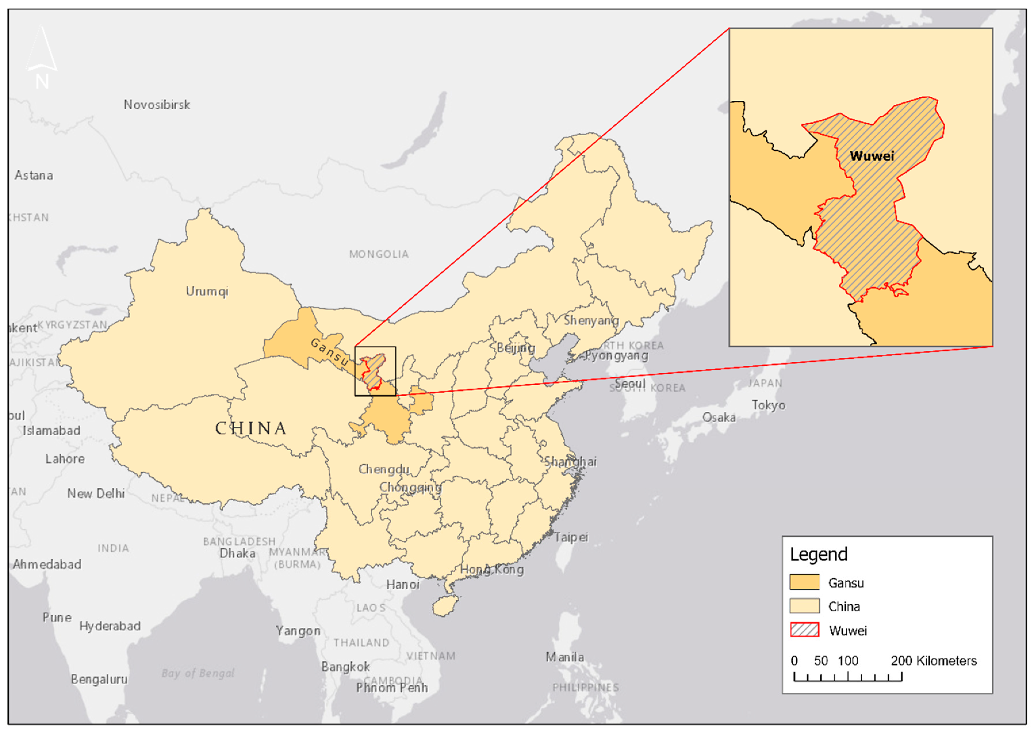
Wuwei governs four districts including the counties of Liangzhou District, Minqin County, Gulang County, and Tianzhu Tibetan Autonomous County in Gansu Province, located in the northwestern region of China (see Figure 2).
A detailed spatial analysis is essential to show the characteristics and challenges in the region due to water scarcity. Therefore, such an analysis must analyze and present information about the geographical location, population, climate and geographical conditions, agricultural products such as food production, water supply, wastewater disposal, the water quality of treated wastewater, and the water consumption per inhabitant.
2.1.1. Population and Population Growth in Wuwei
The prefecture-level city Wuwei, with its four administrative counties known as districts, contains a total of 1,815,059 inhabitants based on census data from 2010 [20]. Compared to the population in 2000, the population in this city has decreased slightly to 1,836,986. The population estimate for 2018 (1,827,800 inhabitants) shows that there was no population growth compared to the 2010 census data (these data are based on the latest status of the census data; data from 2020 are not available). Liangzhou is the most populous district and has more than one million inhabitants. The other three counties are less densely populated (see Figure 3). The population is similar to common Chinese rural areas, where the total area is based on 50 inhabitants per km2, which indicates a sparsely populated area [21]. In total, 72.5% of the total population lives in rural areas (1,315,713 inhabitants; thus, 499,346 live in urban areas [20]).
2.1.2. Climate and Geography
Wuwei is part of the Shiyang River Basin in the arid region of the Hexi corridor located in Gansu Province [22], and the elevation of the city is 1532 m above sea level [23]. The terrain of the region is higher in the south and lower in the north, features a tilt from southwest to northeast, and represents a typical mountain–oasis–desert ecosystem [22]. Overall, there is almost no precipitation in Wuwei, with only 165 mm per year. December is considered to be the driest month, with 1 mm of precipitation, whereas August has a slightly higher rate, with an average of 40 mm [24].
The Minqin Basin, a sub-basin of Shiyang River (see Figure 4), is especially characterized by low and irregular rainfall. High temperature and evaporation, as well as notable drought periods, can be observed in the area. Due to the severe lack of water resources, this basin is one of the driest zones in the world [25] and one of the most severely desertified regions in China [26]. Gray-brown desert and sandy soils cover almost 50% of Minqin’s area [27]. The land distribution in Wuwei includes 256,000 ha of farmland, 1,538,000 ha of unused land, and 1,620,000 ha of usable natural grassland [28].
2.1.3. Development of the Agricultural Sector in the Region
Agricultural production is the most important economic sector in the region, and more than three-quarters of the population engages in agricultural production [16]. Due to the sunny climate and good land conditions, such as flat land, diverse varieties of agricultural products can be planted in Wuwei. According to the Gansu Provincial People’s Government [28], local agriculturally grown products including corn, commercial vegetables, high-quality melons, brewing grapes, beer-barley, cotton, grape wine, corn-starch, flour, sweet melon, and vegetables, as well as black melon-seeds. Corn takes up the largest share of the area, followed by vegetables [28]. Cotton or brewing grapes take up only a small share of the area.
In the desertified Minqin county, mostly summer spring wheat, corn, cotton, melons, and oil plants are cultivated [14]. Table 1 shows the changes in land-use from 2011 to 2015, with a striking increase in the cultivation of water-intensive crops such as corn. Furthermore, it can be observed that the land-use area decreases slightly [14]. This can probably be explained by the strong growth of other products in greenhouses, which reduces the area of open-field cultivation (Section 2.1.7 and Figure 5).
In the region of Wuwei, crops planted in greenhouses are mainly vegetables (e.g., cucumber, tomato, pepper) and fruits [30]. In Minqin County, common products grown in greenhouses include dragon fruits and Chinese chives [31].
In general, the surface of arable land has increased during recent years, so the area requires more water [16] to irrigate crops during the growing season. This is reinforced by the cultivation of water-intensive crops. This explains the five-meter drop in groundwater levels between 2000 and 2015, as groundwater is frequently extracted and used for irrigation [14]. Furthermore, the intensification of land-use, such as changing the cultivation rotation model from one year-one crop to two crop harvests per year, has increased water demands enormously [30].
2.1.4. Water Resources and Distribution of Use in Wuwei
Water resources in this area are a crucial factor for maintaining the economic sector, especially for agricultural products [32]. In arid areas, the agricultural sector is by far, with 88.5%, the primary user of water resources—e.g., for the irrigation of field crops. Therefore, groundwater [17] and natural surface water are important resources [16] to cover the required water. In total, 64.6% of the water provided in Wuwei comes from surface water and 34.9% of the water supply comes from groundwater. Hence, the exploitation of groundwater is indispensable since the surface water alone is not sufficient (Table 2). Only 0.5% in total came from other water sources, such as water-reuse, with 0.1% (in total 2,000,000 m³ per year, thus 5479 m3/d), and rainfall, with 0.4% (7 million m3) (Table 2). The remaining extracted water is applied to industrial production (4.1%), ecological environmental protection (3.6%), domestic use (2.5%), forestry, animal husbandry, sideline production, and fisheries (1.7%), with urban public use comprising only 0.6% [12].
In the overall region, the Shiyang River Basin is one of the most important sources for water resources. This basin is mainly recharged by precipitation and the water melted from the mountains. The total water supply—and thus consumption—of the Shiyang River Basin was 2522 million m3 in 2010, which includes Wuwei City and Jinchang City [12].
The policy requirements of Jinchang City mandate an average sewage treatment ratio of 60%. By 2020, the reuse of treated wastewater should be increased in the Shiyang River Basin up to 65 million m3 (Wang et al. 2019). According to the presented data [12], it is assumed that 40% (26 million m3 per year resp. 71,233 m3/d) of this value relates to Wuwei.
2.1.5. Impact of High Water Consumption in the Region
Generally, land-use, irrigation methods, and transferring surface water from the outer regions can affect groundwater exploitation. As a consequence, changes in regional groundwater levels can be observed [17]. For instance, focusing on the Minqin Oasis area, the Hongyashan (Figure 4) reservoir is the only surface water source for the region. The water volume decreased by 71% from 1956 to 2009. This decrease resulted from the overuse and pollution of surface water in the upper and middle reaches of the Shiyang River Basin that runs through the Hongyashan reservoir [16]. Additionally, the available surface water decreased due to economic development in the region. The increased water supply caused the river to dry up [22]. Presently, another challenge is the overexploitation of groundwater, which is causing a decline in the groundwater level and the deterioration of the groundwater environment. This will further lead to desertification, increased salinity, and the shrinking of oases [14].
2.1.6. Approaches and Measures to Tackle the Challenges of Water Scarcity
As Wuwei is an important city on the old Silk Road, much attention has been given to environmental consequences in the area, such as desertification, the drying of rivers, declines in the groundwater level, and the exploitation of land and water resources [13]. In Minqin county, for instance, the groundwater-use for farmers is strictly regulated [15]. To alleviate the water crisis in the region, the government implemented two policies. The first policy is the “conversion of cropland to forest and grassland”, and the second refers to “closing motor-wells and reducing cultivated land” [16]. Several studies have shown that by implementing water management strategies, water can be saved. For instance, an agricultural water-saving-potential analysis on a multi-scale was conducted [14] and included the crop-scale, wherein the specific water deficits of field crops were applied to save irrigation water. However, it was observed that water-saving measures, considering the crop-scale, have a negative impact on the yields of certain crops. Moreover, the water-saving potential is determined on a field-scale by calculating the differences between the previous irrigation water consumption and the optimized irrigation water allocation, with adjustments of the crop structure. In this way, water-saving measures on a field-scale can increase crop yields by saving large amounts of irrigation water. The irrigation area-scale refers to the technical measures used to improve irrigation water delivery. For instance, large quantities of water leakages can be saved. In summary, considerable irrigation savings can be achieved through multi-scale water-saving measures for agriculture. As a result, regional water pressure decreases [14].
Another action in Minqin was transferring water from other regions to the county to increase water availability [14]. A water diversion project started in 2001 to improve the situation. Water was diverted from the Yellow River, and the natural river course of Shiyang River was used to transfer the water to the Hongyashan reservoir for storage. Although this project significantly increased the available water supply for agriculture in the region, it was not sufficient to completely alleviate water shortages ([16], with further references).
In the last decade, 3000 wells have been cut off, and the water used for the remaining 4000 wells has been regulated by implementing a per capita water quota. Smart card machines have been installed with built-in water meters. Only half of the previously pumped quantity can now be withdrawn. This has led to a change in land-use. For instance, farmers now grow fewer high-water demand crops, and the farmland close to the desert is being abandoned. A reduction in melon production has been especially observed since, previously, 40% of the cropping area was planted with melon fruits. Today, melons are mainly grown for the farmers’ own consumption [15].
2.1.7. Wuwei Increases Greenhouse Agriculture
One possible answer to the shortage of water and to maintain efficient agriculture is to increase the number of greenhouses in Wuwei. Cultivating crops in greenhouses is more efficient for water usage. In total, 20% to 40% of the water requirements for irrigation can be decreased in comparison to open-field cultivation [34]. Another calculation from a case study in Mozambique presented a water-saving potential of 61% [33]. Hence, changing the field crop cultivation from open-air to greenhouse cultivation can decrease the water demand enormously.
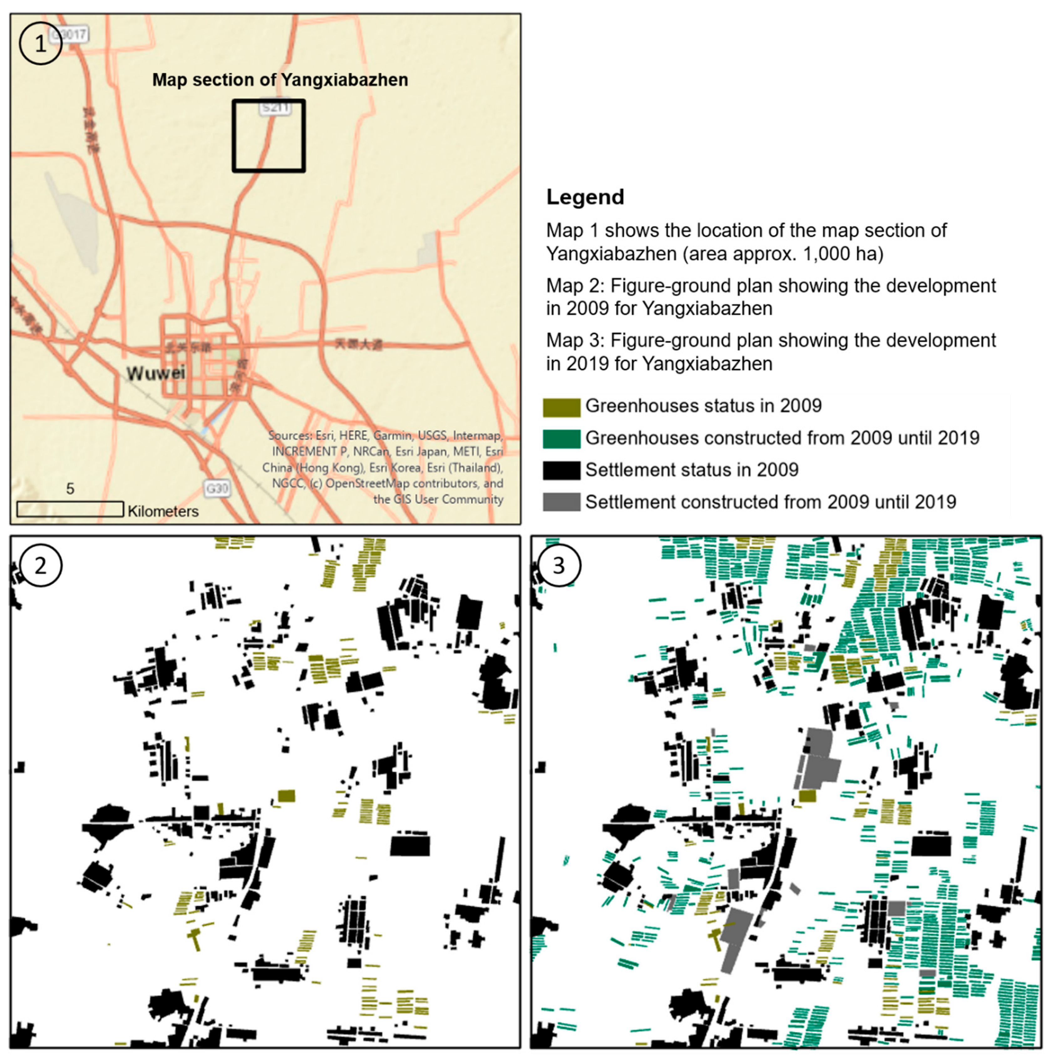
The area used for farming in greenhouses increased enormously from 2009 to 2019 (Figure 5). This was determined by creating figure-ground plans showing the building structure and development of greenhouses for a surface of ~1000 ha. This method is an instrument of urban planning for the representation of constructs, such as buildings, in a selected planned area. For this purpose, aerial photos of the city of Yangxiabazhen from 2009 to 2019 were considered. This small town, with a population of ~16,000 inhabitants [20], is located in the northern suburban region of Wuwei city and is predominantly agricultural. The case study analysis of Yangxiabazhen shows that the total area of greenhouses increased from 1.5% of the total area in 2009 up to 8.5% in 2019. This represents an increase of 483% within ten years.
2.1.8. Discussion: Have the Water Scarcity Challenges for Rural Areas been Addressed?
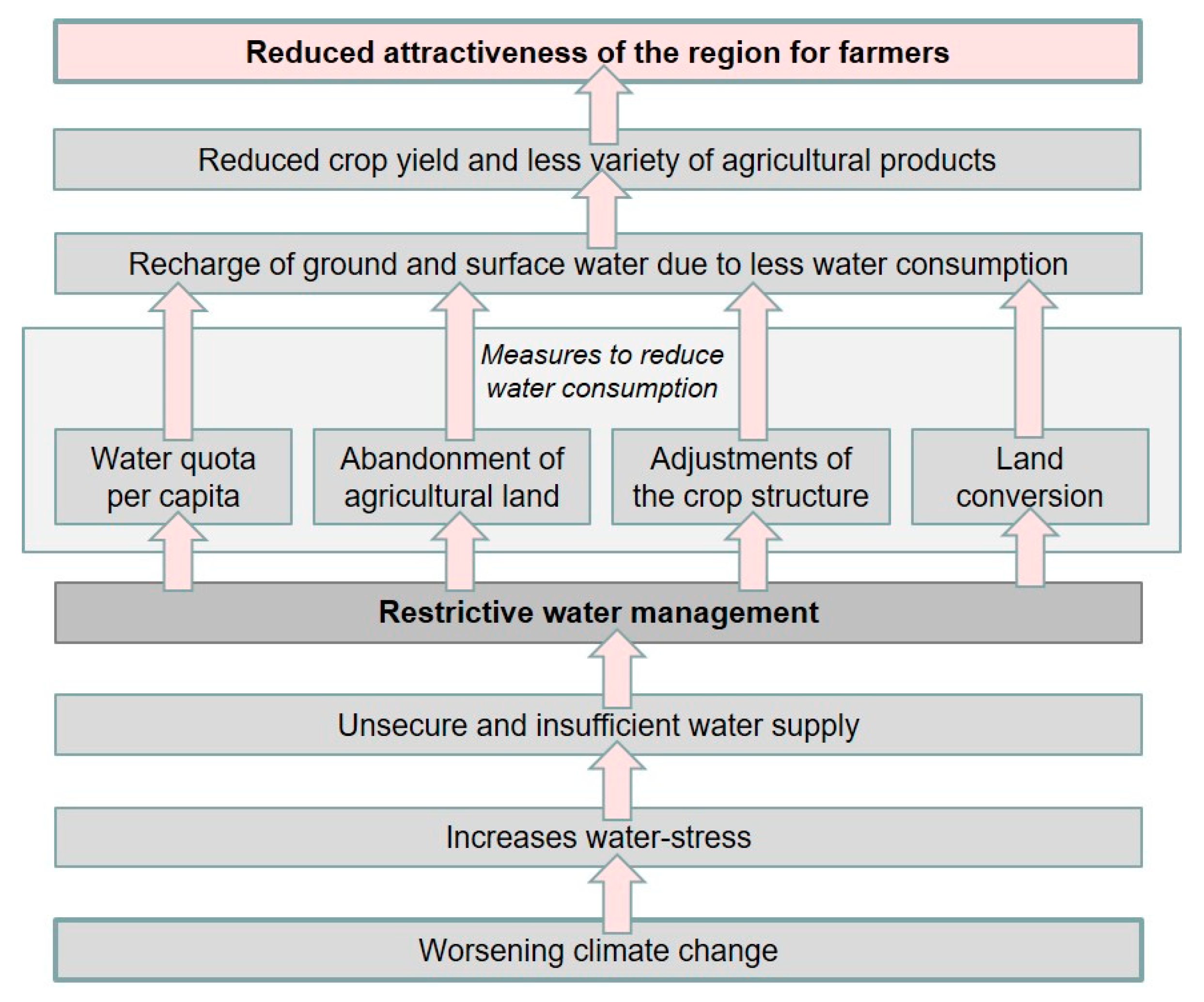
The previous descriptions show that, in general, efficient water management can contribute to decreasing water consumption from natural resources. By implementing a water quota per capita and restricting or abandoning field crop cultivation, the irrigation water demands can be especially decreased. Consequently, pumped groundwater can be reduced, and the groundwater table can be effectively stabilized. Nevertheless, these measures have a profound impact on farmers’ management measures and common practices (Figure 6). If only certain crops are allowed to be planted and/or the area for growing crops is reduced, these changes can have a significant economic impact on local farmers. These measures are necessary for the development of sustainability, especially in the context of water-saving to prevent total overuse. However, they make the region increasingly unattractive for agricultural production due to reduced crop yields and fewer varieties of agricultural products. Furthermore, these measures indirectly weaken the region and make it more difficult to drive new developments.
Available water is far less than the water requirements [14]. Consequently, water-use efficiency and water production efficiency must be improved. It is thus proposed to improve agricultural water management: “Therefore, it is of great significance to analyze the agricultural water-saving potentials with the efficient utilization of limited water and land resources in order to improve agricultural production, promote socioeconomic development, and help ecological restoration” [14]. With this in mind, it is of great importance to improve water efficiency for water-use and production.
A variety of studies focus on the optimization of water-use efficiency, but only a few analyses address an improvement in water production efficiency. Transferring water from outer regions cannot be the final solution. Notably, the topic of reusing treated wastewater has not yet been thoroughly explored to improve the general situation in water-scarce and rural areas. It was shown that little water is provided for water-reuse. Additionally, it was mentioned in previous research [12] that water-reuse must be increased in the future. This paper correlates these observations and focuses on water-reuse potential as a further solution to tackle the challenge of water scarcity. Hence, this paper identifies non-reused water quantities that can be treated and reused in the future for further applications. Since the agricultural sector is the biggest water consumer in Wuwei, the following analyses refer to water-reuse for irrigation of field crops.
2.2. Analysis of Water-Reuse Potential for Wuwei by Using Geoinformation Systems
The following analyses were carried out using a geoinformation system (GIS) in addition to specific aerial photograph analysis. The data required for conducting several spatial analyses, related to the local wastewater treatment capacities in Wuwei, are based on administrative data, such as data from the Ministry of Ecology and Environment of the People’s Republic of China and the Gansu Provincial Water Resources Department.
2.2.1. Estimation of Available Wastewater Flows in Wuwei
To develop a water-reuse concept for Wuwei, all existing WWTPs and their treatment capacities and treatment steps must first be identified. To treat water for reuse, a biological treatment to remove carbon is required. In the second step, all potential wastewater flows that are available but untreated must be determined. According to the Ministry of Ecology and Environment of the People’s Republic of China [18], Wuwei has five municipal WWTPs and three industrial WWTPs (Table 3).
The largest treatment plant is located in Liangzhou, the densest area of Wuwei, which has a treatment capacity of 90,000 m3/d. All other treatment plants have lower capacities of 2000 m3/d up to 12,000 m3/d. In total, the capacity for municipal wastewater is 120,000 m3/d. In addition to municipal WWTPs, Wuwei has three industrial WWTPs with lower treatment capacities. In total, the industrial WWTPs have a capacity of 27,000 m3/d (Table 3). In summary, the wastewater treatment capacity in all counties considering municipal and industrial WWTPs is 147,000 m3/d.
In Gansu Province, the water demand per capita is approximately 119 L per day [19]. Hence, the wastewater inflow to the WWTPs can be calculated for all cities in Wuwei. For this purpose, 101 cities in Wuwei were taken into account, with a total population of ~1.8 million people (three smaller special areas with 13,777 inhabitants were not considered). From this, the total conceivable wastewater flow per day was determined to be 214,353 m3/d. In Wuwei, the treatment capacities, totaling 120,000 m3/d, were only slightly greater than 50% of all municipal wastewater flows treated in a WWTP, whereas the remaining wastewater was untreated.
To elaborate a water-reuse concept, the WWTPs and their estimated catchment areas are needed for cities connected to plants. For this, a geoinformation system (GIS) was used to localize the five existing municipal WWTPs. With the GIS, all cities within the catchment area of the treatment plant can be visualized and (theoretically) defined so that the wastewater produced does not exceed the respective treatment capacity of the WWTP (Figure 7 and Table 3). Therefore, all cities with their population data and wastewater flows based on 119 L per capita per day were considered. Only the number of cities that would not exceed the treatment capacity was assigned to the catchment area of the WWTP. Thus, it was assumed that all cities localized outside the catchment area have no connection to the WWTP. It should be noted that the following findings are based on estimations and may differ from the spatial perspective for some parts of the local situation. Nevertheless, it can be assumed that the proportion of the population not connected to a treatment plant is a realistic value.
For instance, 32 cities and villages are potentially connected to the largest WWTP in Liangzhou, with a wastewater flow of 88,177 m3/d. In total, it is estimated that 40 cities and villages are localized within all catchment areas of the WWTPs with a total of 930,947 inhabitants and a wastewater flow of 110,782 m3/d. Hence, 61 cities and villages with 870,335 inhabitants, located primarily in the rural parts of Wuwei, are not connected to a WWTP. A wastewater flow of 103,571 m3/d (Table 3) is thus untreated but provides potential water flows for water-reuse. The data show that currently only 2.6% of the total estimated accrued wastewater is reused, encompassing 4.9% of the treated wastewater (Table 3). The data also show that even the aforementioned estimated quantities for water-reuse of 71,233 m3/d can be achieved by existing WWTPs, as 110,782 m3/d is estimated for the available treated wastewater flows. However, the extent to which existing plants need to be technically upgraded to meet reused water quality requirements must be examined.
2.2.2. Potential Analysis to Increase Water-Reuse by Building Clusters for Wastewater Treatment Options
To increase wastewater treatment, and thus the availability of reused water, cities and villages not connected to existing WWTPs have been analyzed based on their local situations. For this, the present study considers conceivable treatment options, such as decentralized treatment solutions (including only one city or a smaller cluster with up to four cities), the construction of new WWTPs for a certain catchment area, or the expansion of existing WWTPs. The following map presented in Figure 8 shows a conceivable holistic approach implementing several options based on local situations. To create suitable catchment areas for new WWTPs or their expansion, cities, and villages have been clustered (Figure 8). Therefore, the built-up area was digitized using georeferenced aerial photographs. Additionally, the size of each city was taken into account to derive the respective wastewater treatment capacity for the cluster. The catchment areas of the existing WWTPs were examined to see whether it was possible to expand them so that further villages can be connected to the treatment plant. Thus, long pipe lengths to new WWTPs can be avoided. In this case, the location was spatially examined, as was to what extent areas for an extension of the plant are available. Clusters for new WWTPs were proposed, especially in densely and contiguously populated areas. The population of the cities and villages was taken into account to propose an appropriate size for the WWTP capacity. Since there are many small villages in the high mountains, especially in the south of Wuwei, it is not possible to connect them to a central WWTP. Decentralized solutions are proposed here. However, a decentralized solution is also proposed in flat areas. In these clusters, the villages do not have enough inhabitants, so that the construction of a central WWTP is worthwhile. Moreover, they are too far away from other locations with existing or planned wastewater treatment plants (Figure 8).
3. Results
3.1. Recommendations for Implementing Reuse Water Under Consideration of the Quality Requirements
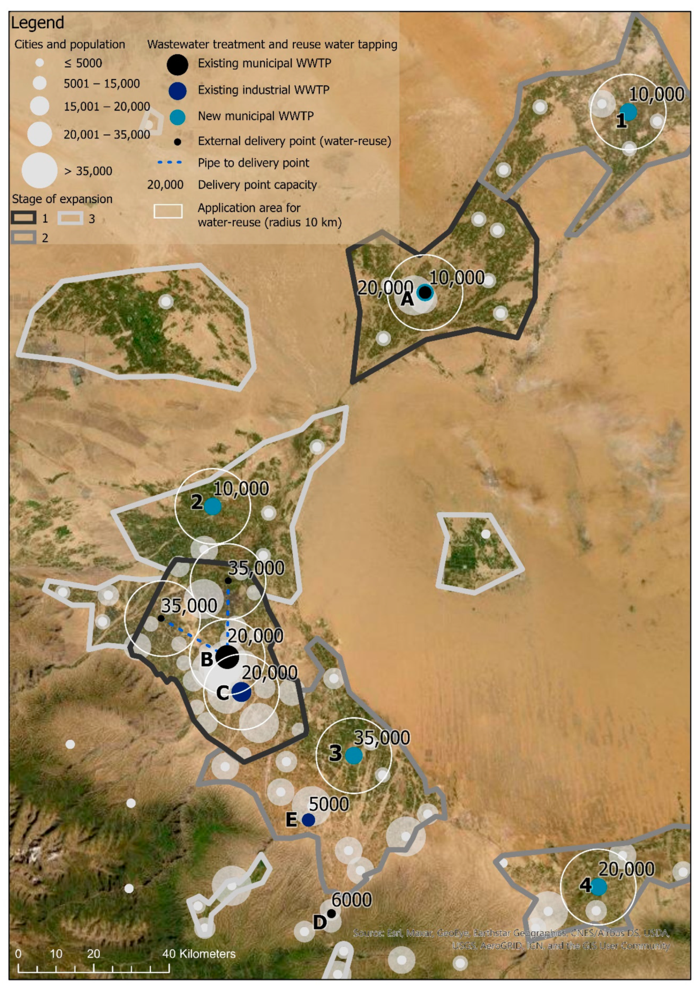
Based on Section 2.2, Figure 9 and Table 4 summarize the existing and new WWTPs with their treatment capacities, catchment areas including inhabitants, and expansion stages. For implementing the reuse of treated wastewater, it is necessary to suggest phases of expansion to increase the reused water resource successively. The first phase of expansion will be the conversion of the two existing WWTPs. For WWTPs A and B (Figure 9), an increase in capacity is necessary as well as the adjustment of the technical aspects to achieve the reuse water quality. Expansion stage 2 includes the new construction of the central WWTPs in order to increase the volume of wastewater treatment in Wuwei by considering the water quality standards for reuse water. The third stage of expansion considers the construction of the decentralized plants.
All municipal and industrial WWTPs located in the case study area received the wastewater quality A or B [19]. Thus, all plants include mechanical and biological treatment processes. Wastewater quality A meets higher standards—e.g., to discharge the treated wastewater into the waterbody. Nitrogen and phosphorus were eliminated. Wastewater quality B contains a higher concentration of both nutrients, which has a positive effect on irrigation purposes due to the fertilization effect. Consequently, the treated wastewater can reach the necessary reused water quality by using an additional treatment step, making the reused water useable for agricultural irrigation. For this, the requirements of the Chinese standard GB/T 22103-2008 (Technology Code for Municipal Wastewater Reuse in Agriculture) must be taken into account. Accordingly, the wastewater must be treated in an additional water-reuse plant (WRP). There, to consider health issues and to reach the required quality, the biologically treated wastewater was filtrated and disinfected by UV and/or chlorine dosing.
For the transportation of reused water, it was proposed to collect the treated wastewater at certain reused water delivery points located at the relevant WWTP. The water was then brought to the user by tanker trucks. Since the WWTP in Liangzhou with a capacity of 90,000 m3/d is located close to the inner city, the water must be pumped through pipes that discharge water to the reused water consumers and thus to the farmers. Hence, this concept proposes the creation of two pipelines to distribute a portion (e.g., 35,000 m3/d) of the provided reused water to rural areas via external delivery points. This procedure ensures a wider scope of application while keeping costs low (Figure 9). It is estimated that an area of 10 km [11] around the treatment plant’s delivery point is a manageable application area that can be used to bring water from the delivery point to the agricultural land. For existing WWTPs with treatment capacities lower than 10,000 m3/d, it was recommended to apply the reused water to surroundings near the delivery point. In order to use the reused water as efficiently as possible, a specific irrigation technique should be chosen to distribute the water. This depends on the field crop to be irrigated. For instance, the water can be sprayed on the fields by means of pumps from the truck. This is the case, for example, in extensive cultivation areas, such as areas with wheat. With this technique, however, the evaporation rate is quite high. Another irrigation option is drip irrigation. This technique is well suited for the irrigation of plants in greenhouses, as these often have permanently installed systems and can be used to irrigate crops that are adapted to these systems. Otherwise, in open-space cultivation, the change of crop is limited by using this technique.
Besides municipal WWTPs, industrial WWTPs were also considered for water-reuse. As the agricultural sector is the strongest economic sector in Wuwei, food is mainly produced at industrial sites [25]. Consequently, the wastewater influent tends to be organically loaded, with little content of, e.g., heavy metals. According to the required quality of the outflows [18,19], this water can be further treated to produce reused water.
3.2. Increase in Water-Reuse in Wuwuei
Section 3.1 and especially Table 4 conclude the results by implementing a water-reuse concept in Wuwei. By summarizing the initial treatment capacities and all capacities generated by the water-reuse concept including municipal and industrial WWTPs, the capacity rises from 147,000 to 232,000 m3/d (58%). Here, an even higher increase can be observed in the availability of reused water. Considering expansion phases 1 and 2, the reused water flow increases enormously from 5479 to 207,461 m3/d (3686%). In addition, the percentage of people connected to a WWTP increases from 52% to 84% (an increase of 63%) due to the implementation of the water-reuse concept.
Considering the total water supply in Wuwei (Table 2), which amounts to 1902 million m3 per year, a positive trend can also be observed due to the increase in water-reuse. In 2010, the share of reused water was only 0.1% with 2 million m3 per year. If the daily available reused water quantities (207,461 m3/d) are considered over the year, consequently approx. 76 million m3 per year are available. Thus, the share of reused water in the total balance increases remarkably from 0.1% up to 4%.
4. Further Impacts for Optimizing Water-Reuse Concepts
4.1. Land-Use and Water Requirements
Since agriculture is the largest water consumer in Wuwei, at 88.5%, strategies concerning the adaption of land-use and land-use changes have to be integrated into the concept in order to reduce the total water consumption and thus to increase the share of reused water. For example, water consumption can be further reduced by growing plants in greenhouses. This will have a positive effect on the proportion of reused water. Such an impact analysis of water-saving measures to land-use and land allocation for optimizing the implementation of water-reuse has not been considered in the previous case study. Besides, for the here-mentioned water-saving methods for Wuwei (Section 2), a great variety of water-saving measures and methods already exist.
An important approach is, for example, the calculation of the water deficit value and the deficit of irrigation for the case study area. This calculation can be a useful parameter for decision-makers to comprehend the magnitude of negative water balance. By having the crops’ water requirements and the crops’ areas, the water balance, and consequently the deficit irrigation water, can be calculated for the respective water supply source. Furthermore, the aforementioned study proposes the calculation of an overexploitation index [35]. This shows, among other things, the ecological impact of water overuse from natural resources, as was also observed in the case study area. Thus, this index could relativize the costs for the production of water-reuse. The higher the index of overexploitation, the more likely it is that policy-makers will advocate the implementation of water-use.
Another method that can be integrated to propose further water-saving measures is the Soil and Water Assessment Tool (SWAT) which was developed by the US Department of Agriculture. Based on local situations, the model can be adopted. It integrates components such as climate, hydrology, erosion, soil temperature, plant growth, nutrients, pesticides, land management, channel, and reservoir routing. By using SWAT in combination with GIS, adaptation strategies can be evaluated such as land-use change scenarios and deficit irrigation for the irrigated crops [36,37].
Another research approach for optimized water-use in arid regions is the analysis of the best location for a particular irrigation method, as this can lead to higher water efficiency under certain drought conditions. For example, the Analytical Hierarchy Process (AHP) could be used as a Multi-Criteria Decision Making (MCDM) method based on a GIS by taking into account local conditions such as climate or topography [38]. Furthermore, location analysis for the proposed new WWTPs and water-reuse plants can be identified by using the best-worst method in a GIS-based Decision Support System (DSS). This method was used, for instance, to identify optimal sites for a rainwater-harvesting agriculture scheme in Iran to ease the overexploitation of groundwater [39].
4.2. Costs for Implementing Water-Reuse
Costs are an important and somehow limiting component for implementing water-reuse concepts. In general, it can be said that the higher the water scarcity in a particular region, the less important the cost of implementing water-reuse concepts. Nevertheless, the objective is to keep costs as low as possible. Different water-reuse concepts show that the costs for the production of reuse water are lower than the costs for providing drinking water from raw water.
The SEMIZENTRAL approach (Section 1) is a suitable example as it shows that a semi-central approach is the most cost-effective solution available. In comparison to centralized or conventional systems, the semi-centralized approach correlates with wastewater, presenting a cost and energy-efficient source for raw water [40]. This applies in particular to natural raw water sources of inferior quality and for long transport routes [41].
Another approach that shows that the production of reusable water is economically viable is the IW2MC→R (Section 1). There, industrial wastewater is treated according to the “fit-for-purpose” principle. Cost analyses show that, for most of the investigated indicators, the installation of a water-reuse plant seems to be advantageous. From an economic point of view, larger quantities of treated water are preferred because the costs per cubic meter of treated water decrease the more water is treated. However, the studies also show that investments in industrial wastewater treatment plants tend to be higher than in municipal WWTPs because they require a higher degree of specialization and automation [42].
Consequently, costs are playing an important role, depending on the local water-scarcity situation and the level of pollution in the treated wastewater. Based on this, the economic efficiency of the concept and the individual clusters must be examined in a further study. The intersection of these disciplines can be an added value for the land management research area.
5. Conclusions
The case study analysis using a geoinformation system shows how the water-reuse potential in rural areas can be identified to improve the local situation. In this way, various spatial analyses can be carried out to identify and propose specific possibilities for improved water-reuse. The results show that by elaborating a holistic water-reuse concept, the local situation can be significantly improved.
To increase water availability, the production of reused water must be increased. As wastewater is a valuable resource, especially in water-scarce regions, the ratio of wastewater must be optimized. Thus, the wastewater among the population that is not connected to a WWTP must be treated and provided for water-reuse. As wastewater is available on a daily basis in calculable quantities, it provides a secure source of water. This potential wastewater must be identified with the help of GIS analyses. Additionally, after identification, this method can assess the local situation to propose water-reuse opportunities. Suitable solutions related to new wastewater treatment options can thus be provided. The present case study analysis shows that the percentage of people connected to a WWTP increases enormously from 52% up to 84% when considering unused water-reuse potential. As a result, more water can be applied to agricultural irrigation. In the best case, the reused water can be increased from 5479 m3 per day to 207,461 m3 per day. This is an increase of 3686%. The total share of reused water in Wuwei will increase from 0.1% to 4%. Furthermore, by constructing new spatially adopted WWTPs, a nearly area-wide supply of reused water can be generated. Long transport routes for the provision of water are also not necessary.
Besides, increasing water availability improves the local living situation. For instance, less pollution of the surface water is a positive consequence due to less wastewater being discharged into water bodies or the landscape. At the same time, more wastewater flows can be treated and made available for water-reuse, and the water withdrawal from natural resources can be reduced. Additionally, less water would need to be transferred to Wuwei from outer regions, thus enabling the region to act more independently.
In particular, this approach should be combined with other concepts to achieve the best possible water-saving results. For instance, the cultivation of high-quality agricultural products in greenhouses combined with the use of reused water can improve the situation of farmers such that harvests can be increased, and a greater variety of agricultural production can be realized, which would increase the attractiveness of the region for farmers. Furthermore, water consumption from natural resources can be reduced by combining water-reuse concepts with land-use strategies adapted to climate change.
The case study shows that to achieve far-reaching results, it is not always necessary to consider individual cities or villages and their respective treatment plants but rather the entire region to realize the optimal production and distribution of reused water. The current study is limited to discussing a land-use and land allocation strategy related to how reused water has an impact on local water management. Moreover, the financing and refinancing of this concept have not yet been considered. Hence, costs for implementing water-reuse may have an impact on the clustering method. If the costs are refinanced by the user, this may in turn have an impact on land-use. Consequently, land policy strategies should be implemented in future studies to enable a fair distribution of reused water.
Funding
This research received no external funding.
Conflicts of Interest
The author declares no conflict of interest.
References
- Zhu, X.; Li, Y.; Li, M.; Pan, Y.; Shi, P. Agricultural irrigation in China. J. Soil Water Conserv. 2013, 68, 147A–154A. [Google Scholar] [CrossRef] [Green Version]
- Lyu, S.; Chen, W.; Zhang, W.; Fan, Y.; Jiao, W. Wastewater reclamation and reuse in China: Opportunities and challenges. J. Environ. Sci. 2016, 39, 86–96. [Google Scholar] [CrossRef] [PubMed]
- Dong, H.-Y.; Qiang, Z.-M.; Wang, W.-D.; Jin, H. Evaluation of rural wastewater treatment processes in a county of eastern China. J. Environ. Monit. 2012, 14, 1906–1913. [Google Scholar] [CrossRef] [PubMed]
- Wang, J.; Huang, J.; Rozelle, S. Climate Change and China’s Agricultural Sector: An Overview of Impacts, Adaptation and Mitigation; International Centre for Trade and Sustainable Development: Geneva, Switzerland; International Food & Agricultural Trade Policy Council: Washington, DC, USA, 2010. [Google Scholar]
- Jiménez, B.; Asano, T. Water Reuse: An International Survey of Current Practice, Issues and Needs; IWA Publishing: London, UK, 2008. [Google Scholar]
- Jaramillo, M.F.; Restrepo, I. Wastewater Reuse in Agriculture: A Review about Its Limitations and Benefits. Sustainability 2017, 9, 1734. [Google Scholar] [CrossRef] [Green Version]
- Udimal, T.B.; Jincai, Z.; Ayamba, E.C.; Owusu, S.M. China’s water situation; the supply of water and the pattern of its usage. Int. J. Sustain. Built Environ. 2017, 6, 491–500. [Google Scholar] [CrossRef]
- Bauer, S.; Linke, H.J.; Wagner, M. Optimizing water-reuse and increasing water-saving potentials by linking treated industrial and municipal wastewater for a sustainable urban development. Water Sci. Technol. 2020, 81, 1927–1940. [Google Scholar] [CrossRef]
- Bauer, S.; Linke, H.J.; Wagner, M. Combining industrial and urban water-reuse concepts for increasing the water resources in water-scarce regions. Water Environ. Res. 2020, 92, 1027–1041. [Google Scholar] [CrossRef]
- Bauer, S.; Dell, A.; Behnisch, J.; Chen, H.; Bi, X.; Nguyen, V.A.; Linke, H.J.; Wagner, M. Water-reuse concepts for industrial parks in water-stressed regions in South East Asia. Water Supply 2020, 20, 296–306. [Google Scholar] [CrossRef]
- SEMIZENTRAL Integrated Supply and Treatment Systems for Fast-Growing Urban Regions. Federal Ministry of Education and Research (BMBF) Funded Research Project. Available online: www.semizentral.de/en/home/ (accessed on 10 June 2020).
- Wang, L.; Zhao, Y.; Huang, Y.; Wang, J.; Li, H.; Zhai, J.; Zhu, Y.; Wang, Q.; Jiang, S. Optimal Water Allocation Based on Water Rights Transaction Models with Administered and Market-Based Systems: A Case Study of Shiyang River Basin, China. Water 2019, 11, 577. [Google Scholar] [CrossRef] [Green Version]
- Wu, H.; Wang, L.; Liu, L.; Hao, L.; Ma, Q.; Li, F.; Guo, L.; Zhang, X.; Zheng, Y. Groundwater recharge and evolution in the Wuwei Basin, northwestern China. Environ. Earth Sci. 2019, 78, 2179. [Google Scholar] [CrossRef]
- Yue, Q.; Zhang, F.; Guo, P. Optimization-Based Agricultural Water-Saving Potential Analysis in Minqin County, Gansu Province China. Water 2018, 10, 1125. [Google Scholar] [CrossRef] [Green Version]
- Herzfeld, T.; Zhanli, S.; Roelcke, M.; Schimming, D. Water and Agriculture in China: Status, Challenges and Options for Actions. In Proceedings of the Background Paper of GFFA Panel China, Hamburg, Germany, 19 January 2017. [Google Scholar]
- Li, C.; Wang, Y.; Qiu, G. Water and Energy Consumption by Agriculture in the Minqin Oasis Region. J. Integr. Agric. 2013, 12, 1330–1340. [Google Scholar] [CrossRef]
- Feng, S.; Huo, Z.; Kang, S.; Tang, Z.; Wang, F. Groundwater simulation using a numerical model under different water resources management scenarios in an arid region of China. Environ. Earth Sci. 2011, 62, 961–971. [Google Scholar] [CrossRef]
- Ministry of Ecology and Environment of the People’s Republic of China. Announcement on the Publication of the National List of Centralized Sewage Treatment Facilities: List of Centralized Sewage Treatment Facilities in Gansu Province. 2020. Available online: http://www.mee.gov.cn/xxgk2018/xxgk/xxgk01/202004/t20200410_773911.html (accessed on 29 May 2020).
- Gansu Provincial Water Resources Department. 2015 Water Resources Bulletin of Gansu Province. Available online: http://www.mee.gov.cn/xxgk2018/xxgk/xxgk01/202004/W020200410603388429107.pdf (accessed on 10 June 2020).
- Citypopulation. Wŭwēi Shì: Prefecture-Level City in Gānsù 2020. Available online: https://www.citypopulation.de/en/china/gansu/admin/6206__wuwei/ (accessed on 27 May 2020).
- Li, M.; He, B.; Guo, R.; Li, Y.; Chen, Y.; Fan, Y. Study on Population Distribution Pattern at the County Level of China. Sustainability 2018, 10, 3598. [Google Scholar] [CrossRef] [Green Version]
- Li, F.; Zhu, G.; Guo, C. Shiyang River ecosystem problems and countermeasures. Agric. Sci. 2013, 4, 72–78. [Google Scholar] [CrossRef] [Green Version]
- Liu, X.; Shao, X.; Zhao, L.; Qin, D.; Chen, T.; Ren, J. Dendroclimatic Temperature Record Derived from Tree-Ring Width and Stable Carbon Isotope Chronologies in the Middle Qilian Mountains, China. Arct. Antarct. Alp. Res. 2007, 39, 651–657. [Google Scholar] [CrossRef]
- Climate-data: Wuwei Climate (China). Available online: https://en.climate-data.org/asia/china/gansu/wuwei-2625/ (accessed on 15 May 2020).
- Zhang, Y.; Ma, J.; Chang, X.; van Wonderen, J.; Yan, L.; Han, J. Water resources assessment in the Minqin Basin: An arid inland river basin under intensive irrigation in northwest China. Environ. Earth Sci. 2012, 65, 1831–1839. [Google Scholar] [CrossRef]
- Huo, Z.; Feng, S.; Kang, S.; Dai, X.; Li, W.; Chen, S. The Response of Water-Land Environment to Human Activities in Arid Minqin Oasis, Northwest China. Arid Land Res. Manag. 2007, 21, 21–36. [Google Scholar] [CrossRef]
- Sun, D.; Dawson, R.; Li, H.; Li, B. Modeling desertification change in Minqin County, China. Environ. Monit. Assess. 2005, 108, 169–188. [Google Scholar] [CrossRef]
- Gansu Provincial People’s Government: Gansu China. Available online: http://www.gansu.gov.cn/col/col3647/index.html (accessed on 19 May 2020).
- Jarvis, A.; Reuter, H.I.; Nelson, A.; Guevara, E. Hole-filled Seamless SRTM data V4, International Centre for Tropical Agriculture (CIAT). 2008. Available online: http://srtm.csi.cgiar.org (accessed on 1 July 2020).
- Chen, Q.; Wang, C.-L.; Hu, M.; Sun, Y. Greenhouse Production Mode in Wuwei City, Gansu Province and Its Benefits Investigation and Analysis. China Veg. 2013, 22, 92–95. [Google Scholar]
- Global Times. Farmers Busy with Farm Work in Greenhouse Across China. 2020. Available online: http://www.globaltimes.cn/content/1130797.shtml (accessed on 10 June 2020).
- Ji, X.; Kang, E.; Chen, R.; Zhao, W.; Zhang, Z.; Jin, B. The impact of the development of water resources on environment in arid inland river basins of Hexi region, Northwestern China. Environ. Geol. 2006, 50, 793–801. [Google Scholar] [CrossRef]
- O’Connor, N.; Mehta, K. Modes of Greenhouse Water Savings. Procedia Eng. 2016, 159, 259–266. [Google Scholar] [CrossRef] [Green Version]
- Nikolaou, G.; Neocleous, D.; Katsoulas, N.; Kittas, C. Irrigation of Greenhouse Crops. Horticulturae 2019, 5, 7. [Google Scholar] [CrossRef] [Green Version]
- Alamanos, A.; Latinopoulos, D.; Xenarios, S.; Tziatzios, G.; Mylopoulos, N.; Loukas, A. Combining hydro-economic and water quality modeling for optimal management of a degraded watershed. J. Hydroinform. 2019, 21, 1118–1129. [Google Scholar] [CrossRef] [Green Version]
- Brouziyne, Y.; Abouabdillah, A.; Hirich, A.; Bouabid, R.; Zaaboul, R.; Benaabidate, L. Modeling sustainable adaptation strategies toward a climate-smart agriculture in a Mediterranean watershed under projected climate change scenarios. Agric. Syst. 2018, 162, 154–163. [Google Scholar] [CrossRef]
- Gebremedhin, K.; Amba, S.; Lakshman, N. Performance Evaluation of SWAT Model for Land Use and Land Cover Changes under different Climatic Conditions: A Review. Hydrol. Curr. Res. 2015, 6, 3. [Google Scholar] [CrossRef]
- Neissi, L.; Albaji, M.; Nasab, S.B. Site Selection of Different Irrigation Systems Using an Analytical Hierarchy Process Integrated with GIS in a Semi-Arid Region. Water Resour. Manag. 2019. [Google Scholar] [CrossRef]
- Aghaloo, K.; Chiu, Y.-R. Identifying Optimal Sites for a Rainwater-Harvesting Agricultural Scheme in Iran Using the Best-Worst Method and Fuzzy Logic in a GIS-Based Decision Support System. Water 2020, 12, 1913. [Google Scholar] [CrossRef]
- Tolksdorf, J.; Shen, W.; Blach, T.; Leinhos, M.; Wagner, M. Wirtschaftlichkeit semizentraler, integrierter Infrastruktursysteme in schnell wachsenden urbanen Räumen am Beispiel SEMIZENTRAL. (Economy of Semicentral, Integrated Infrastructure Systems in Fast-Growing Urban Areas Using SEMIZENTRAL as an Example). Gwfwasser Abwasser 2019, 3, 73–82. [Google Scholar]
- Lazarova, V.; Choo, K.H.; Cornel, P. Meeting the challenges of the water-energy nexus: The role of reuse and wastewater treatment. Water21 2012, 14, 12–17. [Google Scholar]
- Hilbig, J.; Boysen, B.; Wolfsdorf, P.; Rudolph, K.-U. Economic evaluation of different treatment options for water reuse in industrial parks using modular cost functions. J. Water Reuse Desalin. 2020, in press. [Google Scholar] [CrossRef]
Figure 1.
Water-reuse concept as a key element for strengthening rural areas (own figure).
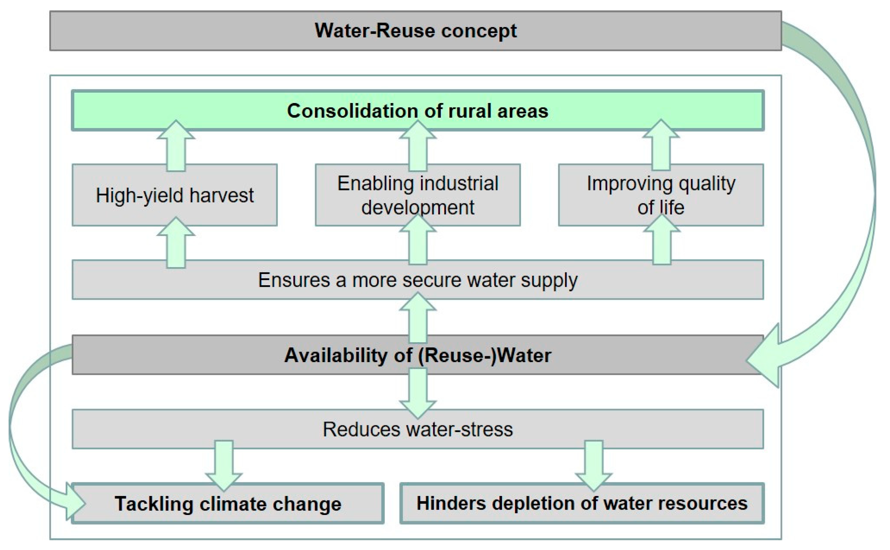
Figure 2.
Location of Wuwei in Gansu Province, China (own map, administrative boundaries are based on Database of Global Administrative Areas (GADM data)).
Figure 2.
Location of Wuwei in Gansu Province, China (own map, administrative boundaries are based on Database of Global Administrative Areas (GADM data)).

Figure 3.
Population in Wuwei and its counties (own map, administrative boundaries are based on Database of Global Administrative Areas (GADM data) data and [11]).
Figure 3.
Population in Wuwei and its counties (own map, administrative boundaries are based on Database of Global Administrative Areas (GADM data) data and [11]).
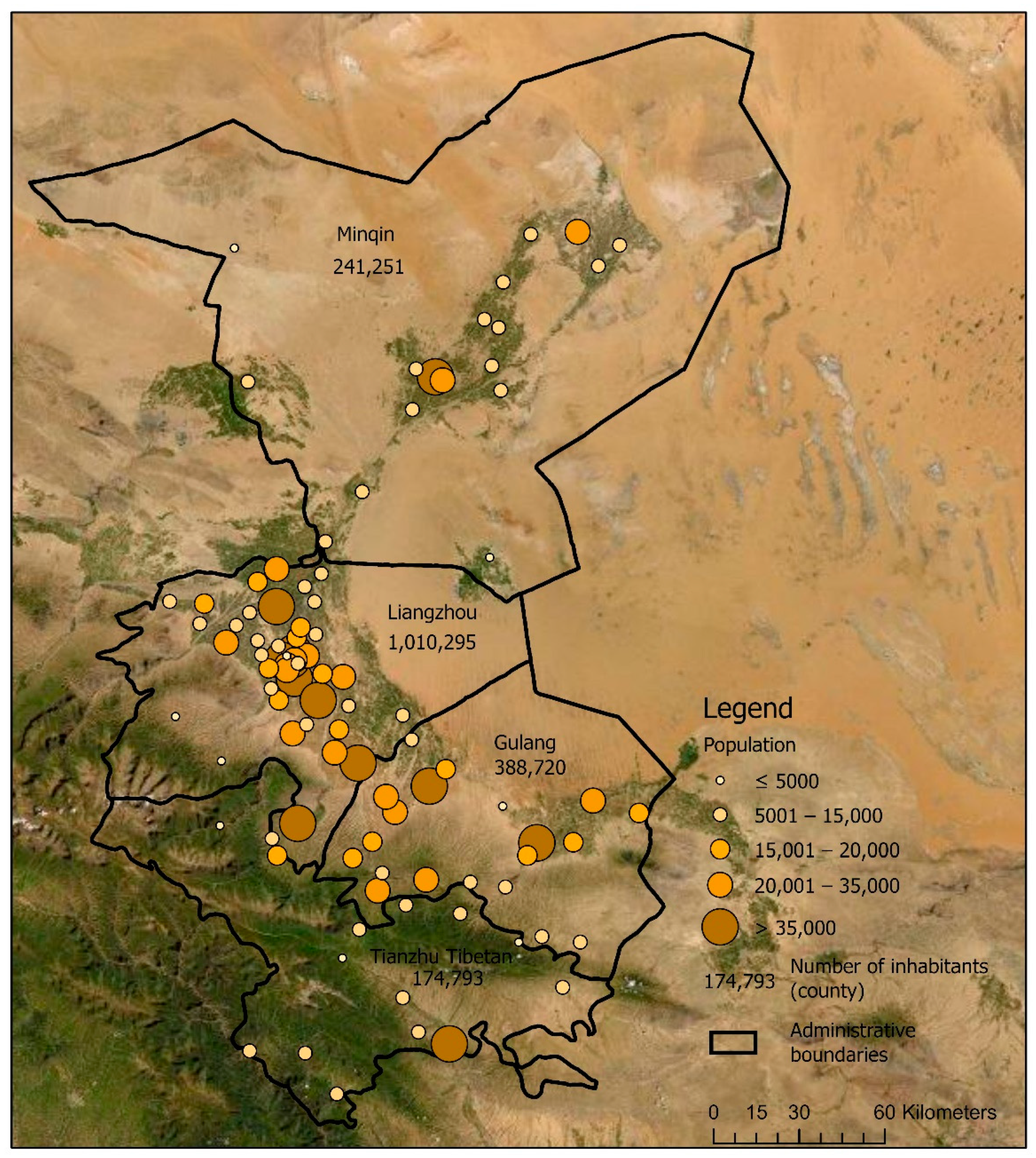
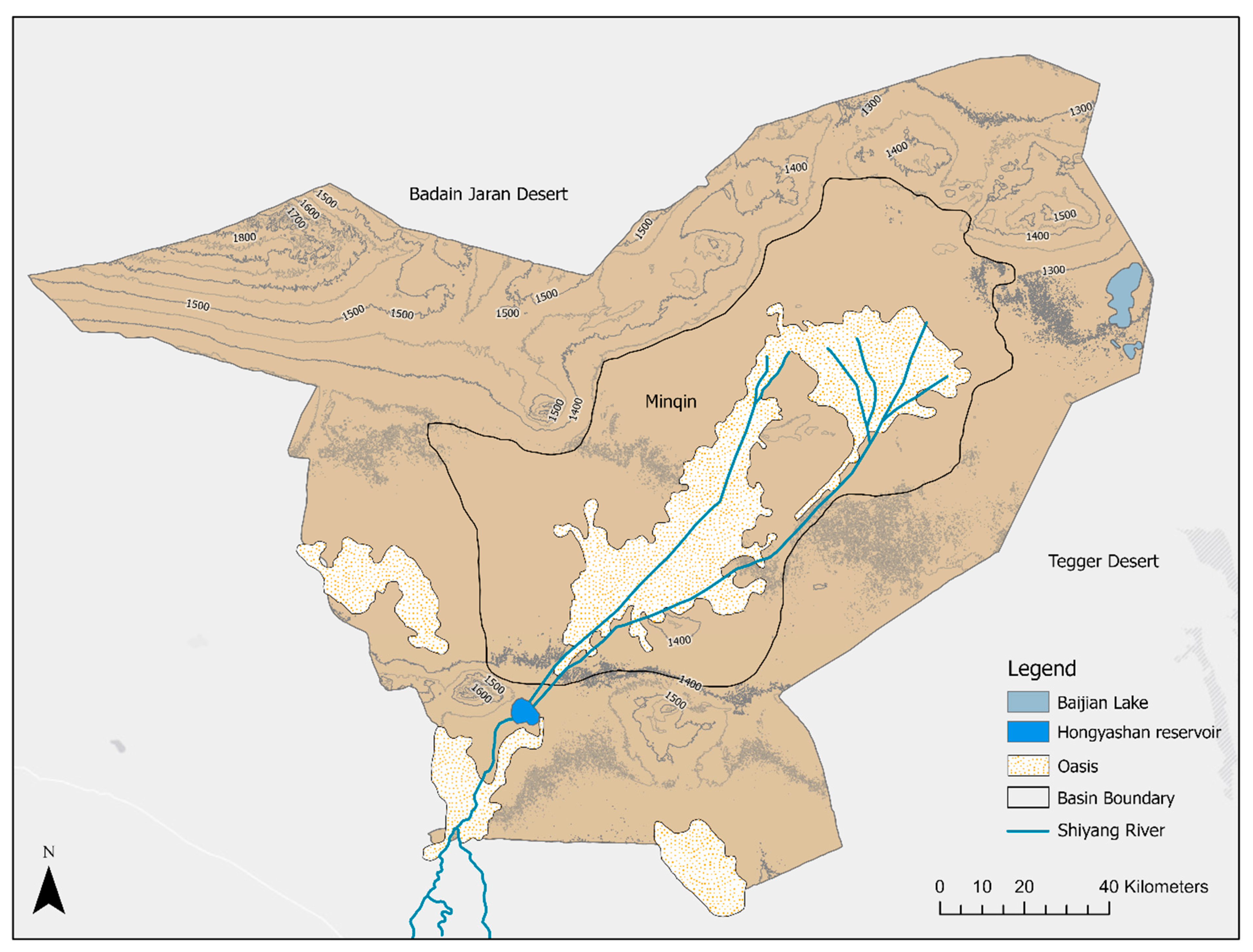
Figure 5.
Figure-ground plans showing the development of greenhouses for a map section of Yangxiabazhen from 2009 to 2019 (own analysis).
Figure 5.
Figure-ground plans showing the development of greenhouses for a map section of Yangxiabazhen from 2009 to 2019 (own analysis).

Figure 6.
The impact of the restrictive water management on rural areas (own figure).

Figure 7.
Locations of WWTPs including capacity and catchment areas (own map, administrative boundaries are based on Database of Global Administrative Areas (GADM data).
Figure 7.
Locations of WWTPs including capacity and catchment areas (own map, administrative boundaries are based on Database of Global Administrative Areas (GADM data).
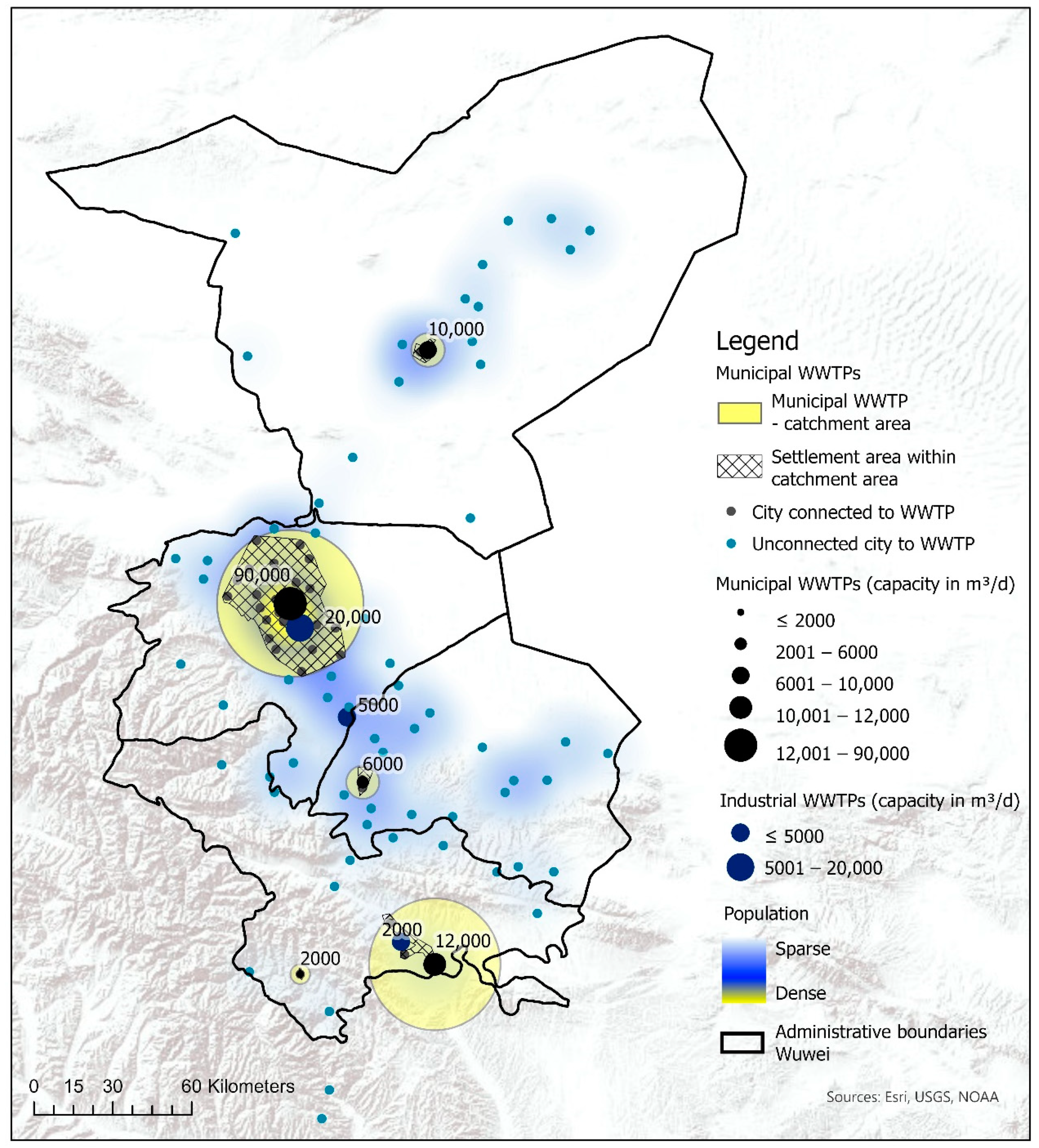
Figure 8.
Increasing reused water availability by implementing further wastewater treatment options (own map; administrative boundaries are based on Database of Global Administrative Areas (GADM data)).
Figure 8.
Increasing reused water availability by implementing further wastewater treatment options (own map; administrative boundaries are based on Database of Global Administrative Areas (GADM data)).
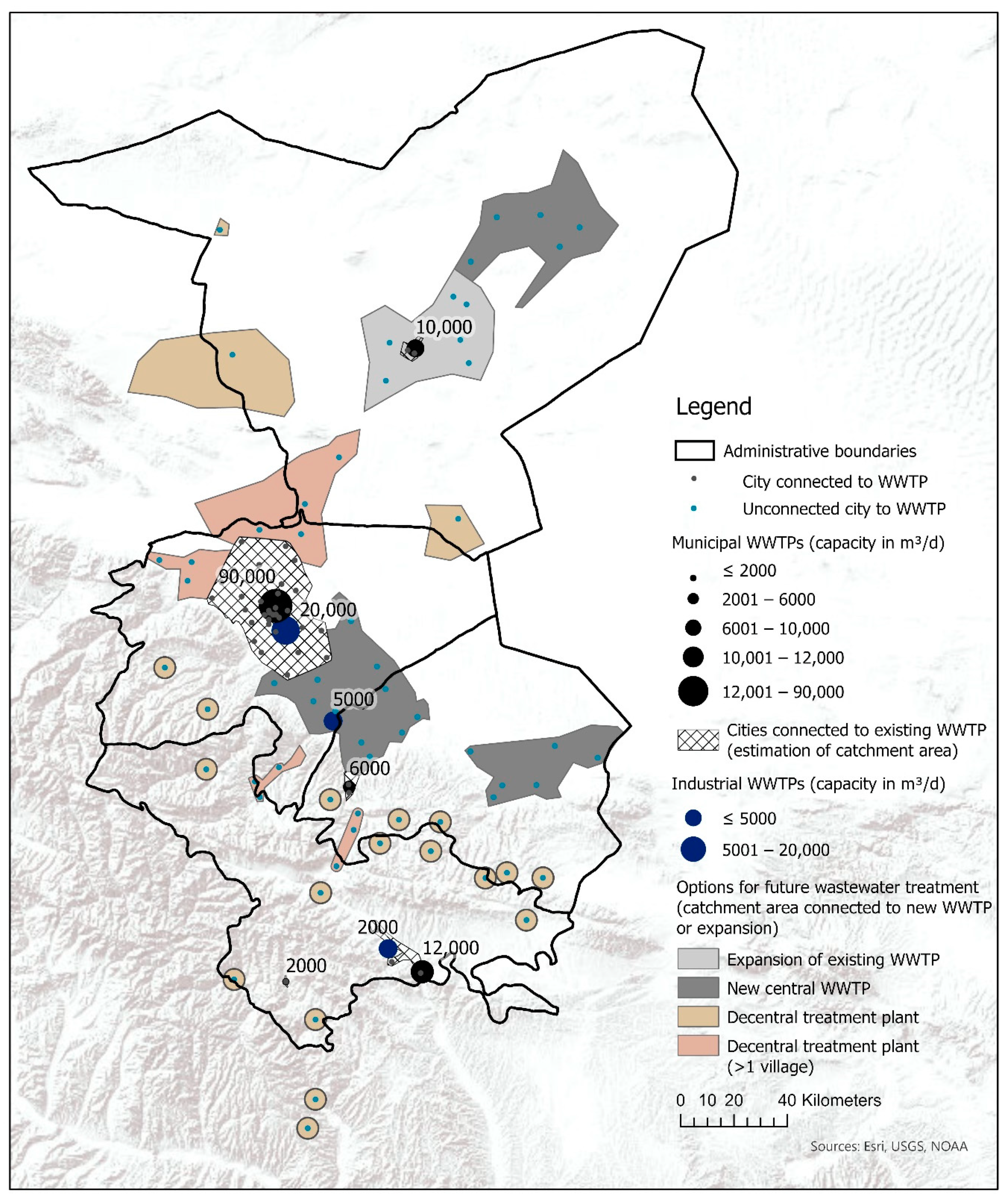
Figure 9.
Water-reuse concept with recommended capacities for WWTPs and new delivery points.


Table 1.
Quantitative distribution of field crops in Minquin and irrigation requirements (based on [14]).
Table 1.
Quantitative distribution of field crops in Minquin and irrigation requirements (based on [14]).
| Field Crop | Cultivation Area 2011 | Cultivation Area 2015 | Increase/Decrease | Irrigation Quota/mm per Growing Season |
|---|---|---|---|---|
| Spring wheat | 7400 ha | 4674 ha | −37% | 350–400 |
| Corn | 5387 ha | 9967 ha | +85% | 400–450 |
| Cotton | 12,827 ha | 5000 ha | −61% | 300–350 |
| Oil Flex | 7160 ha | 11,514 ha | +61% | 300–350 |
| Seed Melon | 2107 ha | 2473 ha | 17% | 350–400 |
| total | 34,881 ha | 33,628 ha | −4% |
Table 2.
Water balance in 2010 for Wuwei (Source: own table, data according to [12]).
Table 2.
Water balance in 2010 for Wuwei (Source: own table, data according to [12]).
| Water Source for Water Supply | Water Supply in Million m3 in 2010 | Water Supply Distribution | |
|---|---|---|---|
| Surface water | 1229 | 64.6% | |
| Groundwater | 664 | 34.9% | |
| Other | Reuse | 2 | 0.1% |
| Rainfall | 7 | 0.4% | |
| Sum | 1902 | 100% | |
| Purpose | Water Consumption in Million m3 in 2010 | Water Consumption Distribution | |
| Agriculture | 1683 | 88.5% | |
| Industrial production | 78 | 4.1% | |
| Domestic use | 48 | 2.5% | |
| Urban public use | 11 | 0.6% | |
| FASF * | 32 | 1.7% | |
| Ecological environment protection | 69 | 3.6% | |
| Sum | 1921 ** | 100% | |
* FASF represents forestry, animal husbandry, sideline production, and fisheries. ** The water balance shows a loss of 19 million m3 per year which is less than 1% of the total water supply. This water balance gap is to be regarded as rather insignificant for a balance of this size and not further considered. The deviation can possibly be justified by measurement or rounding errors.
Table 3.
Estimation of treated and untreated wastewater flows to calculate reused-water potential (own analysis; wastewater treatment capacities according to the Ministry of Ecology and Environment of the People’s Republic of China [18]).
Table 3.
Estimation of treated and untreated wastewater flows to calculate reused-water potential (own analysis; wastewater treatment capacities according to the Ministry of Ecology and Environment of the People’s Republic of China [18]).
| County | Town | Treatment Capacity [m3/d] | Number of Cities | Population | Wastewater Flows [m3/d] * | Ratio |
|---|---|---|---|---|---|---|
| Estimated connections to a wastewater treatment plant (WWTP) | ||||||
| Liangzhou | Jinyang Zhen | 90,000 1 | 32 | 740,991 | 88,177 | |
| Tianzhu | Huazangsi Zhen | 12,000 1 | 3 | 70,420 | 8381 | |
| Minqin | Suwu Zhen | 10,000 1 | 2 | 74,577 | 8874 | |
| Gulang | Gulang Zhen | 6000 1 | 2 | 37,808 | 4499 | |
| Tianzhu | Tanshanling Zhen | 2000 1 | 1 | 7151 | 851 | |
| Sum | 120,000 1 | 40 | 930,947 | 110,782 | 52% | |
| Liangzhou | Gaoba Zhen | 20,000 2 | - | - | unknown | |
| Liangzhou | Huangyang Zhen | 5000 2 | - | - | unknown | |
| Tianzhu | Kuangou | 2000 2 | - | - | unknown | |
| Sum | 27,000 2 | |||||
| Estimates for cities unconnected to a WWTP | ||||||
| Sum | 61 | 870,335 | 103,571 | 48% | ||
| Total wastewater flows based on Wuwei’s population | ||||||
| Total | 101 | 1,801,282 | 214,353 | 100% | ||
| Water-reuse ratio | ||||||
| Water-reuse ratio related to treated wastewater | ||||||
| 5479 m3/d of 110,782 m3/d is reused | 4.9% | |||||
| Water-reuse ratio related to the total wastewater flow | ||||||
| 5479 m3/d of 214,353 m3/d is reused | 2.6% | |||||
1 Municiapl WWTP; 2 Industrial WWTP; * Based on 119 m3/d per capita.
Table 4.
Increasing reused water availability by implementing further wastewater treatment options.
| No. | Recommendation for Action (WWTP) | Type of Reused Water Provision | Wastewater Treatment Capacity [m3/d] | INHABITANTS of Cluster | Wastewater Flow [m3/d] = Reused Water Flow ** | No. of Connected Cities |
|---|---|---|---|---|---|---|
| 1 | Construction of new WWTP | Delivery point at WWTP | 10,000 | 67,354 | 8015 | 5 |
| 2 | Construction of new WWTP | Delivery point at WWTP | 10,000 | 58,492 | 6961 | 4 |
| 3 | Construction of new WWTP | Delivery point at WWTP | 35,000 | 261,538 | 31,123 | 11 |
| 4 | Construction of new WWTP | Delivery point at WWTP | 20,000 | 127,067 | 15,121 | 6 |
| A | Expansion of existing WWTP and modification for water-reuse | Delivery point at WWTP | 20,000 | 145,657 | 17,333 | 8 |
| B | Modification of existing municipal WWTP for water-reuse | Delivery point at WWTP and new pipeline to external delivery points | 90,000 | 740,991 | 88,177 | 32 |
| C | Modification of existing industrial plant for water-reuse | Delivery point at WWTP | 20,000 | - | 20,000 | - |
| D | Modification of existing municipal WWTP for water-reuse | Delivery point at WWTP | 6000 | 37,808 | 4499 | 2 |
| E | Modification of existing industrial WWTP for water-reuse | Delivery point at WWTP | 5000 | - | 5000 | |
| * | Modification of existing municipal WWTP for water-reuse | Delivery point at WWTP | 12,000 | 70,420 | 8381 | 3 |
| * | Modification of existing municipal WWTP for water-reuse | Delivery point at WWTP | 2000 | 7151 | 851 | 1 |
| * | Modification of existing industrial WWTP for water-reuse | Delivery point at WWTP | 2000 | - | 2000 | |
| Sum (expansion phase 1 and 2) | 232,000 | 1,516,478 | 207,461 | 72 | ||
| Sum (current situation) | 147,000 | 930,947 | 5479 | 40 | ||
| Increasing rate (%) by implementing the water-reuse concept | 58% | 63% | 3686% | 80% | ||
| Total | 1,801,282 | 214,353 | 101 | |||
| Coverage ratio in % | 84% | 97% | 71% | |||
* not presented in Figure 9. ** 100% water-reuse is assumed. If the receiving water body requires the discharge of a certain water flow, the volume is reduced by a percentage to be defined.
Publisher’s Note: MDPI stays neutral with regard to jurisdictional claims in published maps and institutional affiliations. |
© 2020 by the author. Licensee MDPI, Basel, Switzerland. This article is an open access article distributed under the terms and conditions of the Creative Commons Attribution (CC BY) license (http://creativecommons.org/licenses/by/4.0/).
Share and Cite
MDPI and ACS Style
Bauer, S. Identification of Water-Reuse Potentials to Strengthen Rural Areas in Water-Scarce Regions—The Case Study of Wuwei. Land 2020, 9, 492. https://doi.org/10.3390/land9120492
AMA Style
Bauer S. Identification of Water-Reuse Potentials to Strengthen Rural Areas in Water-Scarce Regions—The Case Study of Wuwei. Land. 2020; 9(12):492. https://doi.org/10.3390/land9120492
Chicago/Turabian StyleBauer, Sonja. 2020. "Identification of Water-Reuse Potentials to Strengthen Rural Areas in Water-Scarce Regions—The Case Study of Wuwei" Land 9, no. 12: 492. https://doi.org/10.3390/land9120492
Note that from the first issue of 2016, this journal uses article numbers instead of page numbers. See further details here.