Article

The Huerta Agricultural Landscape in the Spanish Mediterranean Arc: One Landscape, Two Perspectives, Three Specific Huertas

Urban Design and Regional Planning Unit, Building Sciences and Urbanism Department, University of Alicante, E-03080 Alicante, Spain
*
Author to whom correspondence should be addressed.
Land 2020, 9(11), 460; https://doi.org/10.3390/land9110460
Submission received: 13 October 2020 / Revised: 15 November 2020 / Accepted: 16 November 2020 / Published: 18 November 2020
(This article belongs to the Section Landscape Ecology)

Abstract

:
The Huerta is recognised as one of the 13 specific agricultural landscapes in Europe, present in only three Mediterranean countries, namely Spain, Italy, and Greece. In the case of Spain, three areas fall within the established Huerta agricultural classification: the Huertas de Valencia, Murcia, and Vega Baja. While all of them share common landscape features, each Huerta has distinguishing singularities which are approached through two perspectives: firstly, the structural tangible elements, related to functional networks—water distribution, pathways networks, settlement patterns, and the agricultural production system; and secondly, the role of the intangible components—connotations of the word Huerta, water management, canal and path upkeep rules, and the administration of these territories. The analysis of the tangible elements and intangible components in the three Spanish Huertas shows these territories as complex and balanced systems that have historically counterbalanced the environmental drawbacks in one of the most arid European regions. Despite being a highly appreciated environmental and productive asset, these Huertas are under intense pressure from urban development in highly urbanized metropolitan areas. This study shows Huertas’ uniqueness through their historical role in the territorial planning and management strategies at the local level, finally depicting Huertas as a present strategical opportunity for reaching environmental goals in peri-urban areas.

1. Introduction

The Huerta is one of the 13 types of European agricultural landscapes identified in the compilation put forward by J.H.A. Meeus, M.P. Wijermans, and M.J. Vroom in 1990. It distinguishes specific areas resulting from research into the interaction between agriculture and landscape at a continental scale by focusing on climate, slope, and image. In the case of the Huerta agricultural landscape, they were all identified as open valleys in the Mediterranean area [1].
Despite the Huerta landscape having been well known at the local level from its inception, awareness of its uniqueness in Europe did not emerge until this map, reproduced in Figure 1 left, was published in 1990. Only six territories—located in Spain, Italy, and Greece—belong to this landscape category, defined by “its origins and its regional context” [1]. The map indicates the present-day scarcity of the Huerta area as an agricultural structure in the European context, within the Mediterranean Arc countries. Subsequently, based on the aforementioned map, the European Environmental Agency in the Dobris Report [2] highlighted for the first time the various European landscapes, including the Huerta. The specific areas of Huerta along the coast of the Mediterranean Sea are grouped under the “Artificial Landscapes” heading (Figure 1).
The Huerta Landscape has been shaped by human activities and the land’s geo-morphological characteristics. They are intensively farmed soils of Europe which have been transformed and exploited over the course of centuries, providing high benefits in terms of the quality, quantity, and variety of crops [3]. Thus, from their inception, the richness and mixture of agricultural production, related to soil, climate, and water resources, have contributed not only to define the spatiality of each area—tangible elements—but also to develop specific features of the immaterial heritage factors—intangible components—all of them, expressions of Huerta landscape characterization.
For centuries, inhabitants of these regions made this fertile ground their most precious asset and ultimately it became the backbone of the local economy. The Huerta entails a genuine 10-century long process of agricultural tasks based on the management of the scarce water to produce intensely irrigated cropping [4]. It develops an original settlement system in harmony with environmental peculiarities, supported by an extensive path network to ensure mobility and accessibility [5,6].
In the last 25 years, Europe has undergone many changes at an incredibly rapid pace. New structures have been superimposed onto old systems and new policies have been developed and implemented on the landscape, agriculture, and environment, affecting each territory distinctively [7,8,9]. Landscapes are dynamic and thereby change is one of their properties. However, their evolution is affected not only by the speed and scale of their transformation but also by user perceptions and aspirations which, in turn, determine users’ behaviour [10]. Despite being initially located in rural areas, nowadays these territories are influenced by metropolitan agglomerations that have evolved through the process of extension and densification of ancient urban settlements [11]. Now, these fertile areas are fading in the peri-urban fringe, where empty spaces and abandoned agricultural plots are increasingly emerging [7,12,13,14]. Notwithstanding the above, Huertas’ location and extension make them a tactical asset for reaching European Union urban and peri-urban agriculture goals—UPUA [15].
Recently, some of the most relevant issues for the EU policies agenda are related to agriculture in the EU, specifically urban and peri-urban agriculture (UPUA). This is a highly diverse phenomenon, which links territory, society, economic transformations, EU strategic objectives on regional food system approaches, environmental issues, and public health, among others. It has been over the last decades when UPUA has gained increasing awareness and several European research projects have arisen. There has been an investment of 142,872,500 € of European public funds within 41 research projects and initiatives in the period comprised between 2001 and 2022—some of them are ongoing programs [15]. A systematic understanding of how these specific Huerta territories are more than simply agriculture production is still lacking. While some research has been carried out on describing the Huertas historical evolution [16,17], the irrigation system [18,19], or the impacts of their peri-urban location [20,21,22], no studies have been found addressing a deeper understanding of the linkage between tangible elements and intangible components, in order to highlight the system complexity and differentiating values as a whole, contrasting with other agricultural areas. Additionally, despite representing a highly valued landscape belonging to the same area, differences within territorial policies and land management have been detected between these three Huertas [23].
This article explores the spatial and cultural singularities of the Spanish Huerta landscapes, located along the Spanish Mediterranean Arc in the Valencian Community and Murcia Region. Three Huertas have been identified: the Huerta de Valencia, which is situated in the final stretch of the Turia River and comprises the territories within the metropolitan area of Valencia; the Huerta de Murcia, situated along the middle stretch of the Segura River floodplain in the province of Murcia; and the Huerta de la Vega Baja, which follows the final stretch of the Segura River floodplain in the province of Alicante. Although the latter ones belong to the same river basin and are part of an interdependent system with the same origin, their historical evolution and territorial occupancy have affected them differently. For this reason, this article presents a clear distinction between three Huertas within the southeast Spanish territory, thereby considering the local particularities: Valencia, Murcia, and Vega Baja (Figure 2).
The overall aim of this paper is to reflect the relevance of the Huerta landscape in the Spanish Mediterranean Arc in terms of their singularities and territorial role, also showing their contribution to balance a multifunctional complex system. For this purpose three objectives have been set: firstly, to characterize the structural tangible elements, which shape the spatial Huerta landform, and to identify the similarities and differences between each Huerta area; secondly, to distinguish the characteristics and roles of the intangible components and their impact on territorial landscape features; and thirdly, to correlate tangible elements and intangible components so as to understand how they define each territory’s singularity as well as landscape identity.
Embodied in the title of this study is the concept of synthesis which represents a key component in this research: one landscape, the Mediterranean Spanish Huerta; two perspectives through the material elements and intangible features; and three geographical areas: Valencia, Murcia, and Vega Baja. The word Huerta is written in italic font as a proper noun because it refers to a Spanish term for a specific agricultural landscape. It is also written in italic font when it defines a specific place, using its Spanish name such as the Huerta de Valencia, Huerta de Murcia, and Huerta de la Vega Baja.

2. Methodology. Comparative Case Studies

In order to address the above objectives, the methodology implemented is comparative case studies, involving the analysis and synthesis of the similarities, differences, and patterns. So that both territorial elements—tangible—as well as cultural aspects—intangible—are identified and compared; and subsequently, a discussion follows on how the differences observed between all three Huertas affect the way in which the landscape is perceived and managed presently. The following tangible elements—specific physical networks: water, paths, settlements, and field crops—define the Huerta’s functional existence and shape its morphology [24]. The intangible components encompass the cultural and extra-legislative norms that manage these territories, with specific reference to water stewardship.
The data used in this research are obtained from several information sources that provide an in-depth understanding of all tangible elements and intangible components. These include the following: historical cartography provides evidence of the role that each tangible element has played in the evolution of the territory [19,25,26,27,28,29,30]; specialized literature identifies the intangible components and their relevant features [31,32,33,34]; public administration data and cartography offer the baseline and present-day context for the analysis framework [28,29,35,36]; and fieldwork is a useful tool to cross-check aforementioned approaches.
In the following section, analysis of each structural component is provided for the three case studies and specific descriptions are developed incorporating features present in the cartography. The results reveal the similarities and differences between the three Huertas. They also explain the interdependency between the components and highlight the respective Huertas’ territorial identity.
Further clarification is needed in relation to the name and location of all three Huertas case studies. The northernmost example is Valencia, where the name Huerta de Valencia is self-explanatory because it refers to the surroundings of Valencia City and belongs to the province of the same name. In contrast, the southern examples are two areas that belong to the same river basin. The first one, the Huerta de Murcia is named as such up until it reaches the territorial boundaries that separate Murcia from Alicante province. Thereafter, the area that belongs to Alicante is known by three different names in reference to firstly, the history, Huerta de Orihuela, related to the preeminent position of this city for several centuries; secondly, a geo-morphology, connected with the Segura river’s final reach, Huerta de la Vega Baja; and, thirdly, Huerta del Bajo Segura related to the current official name of the county in which it is located. For this study’s purposes, the second one, Huerta de la Vega Baja, will be the term used to identify this area of agricultural land in the last Segura River stretch crossing the province of Alicante.

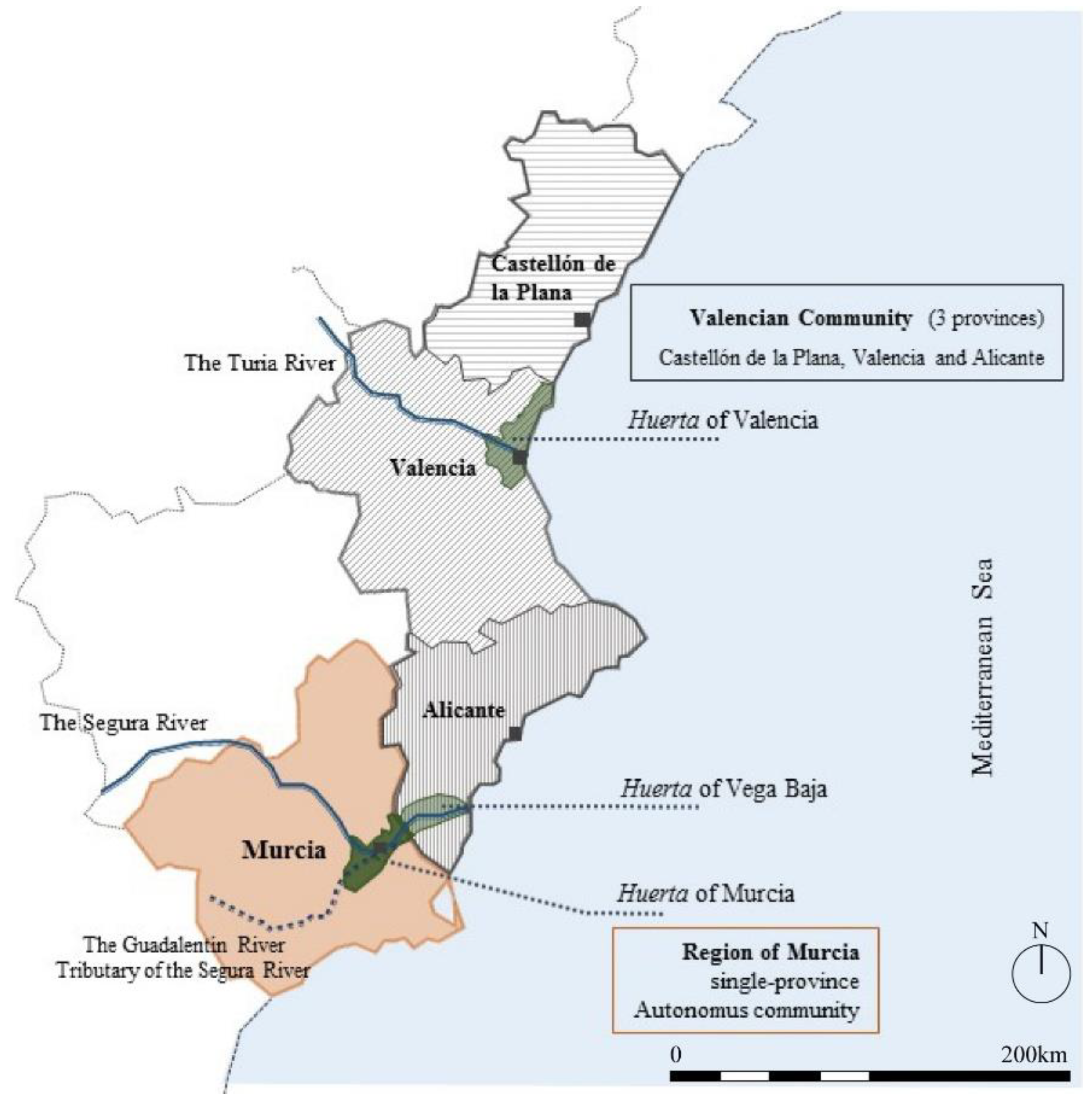
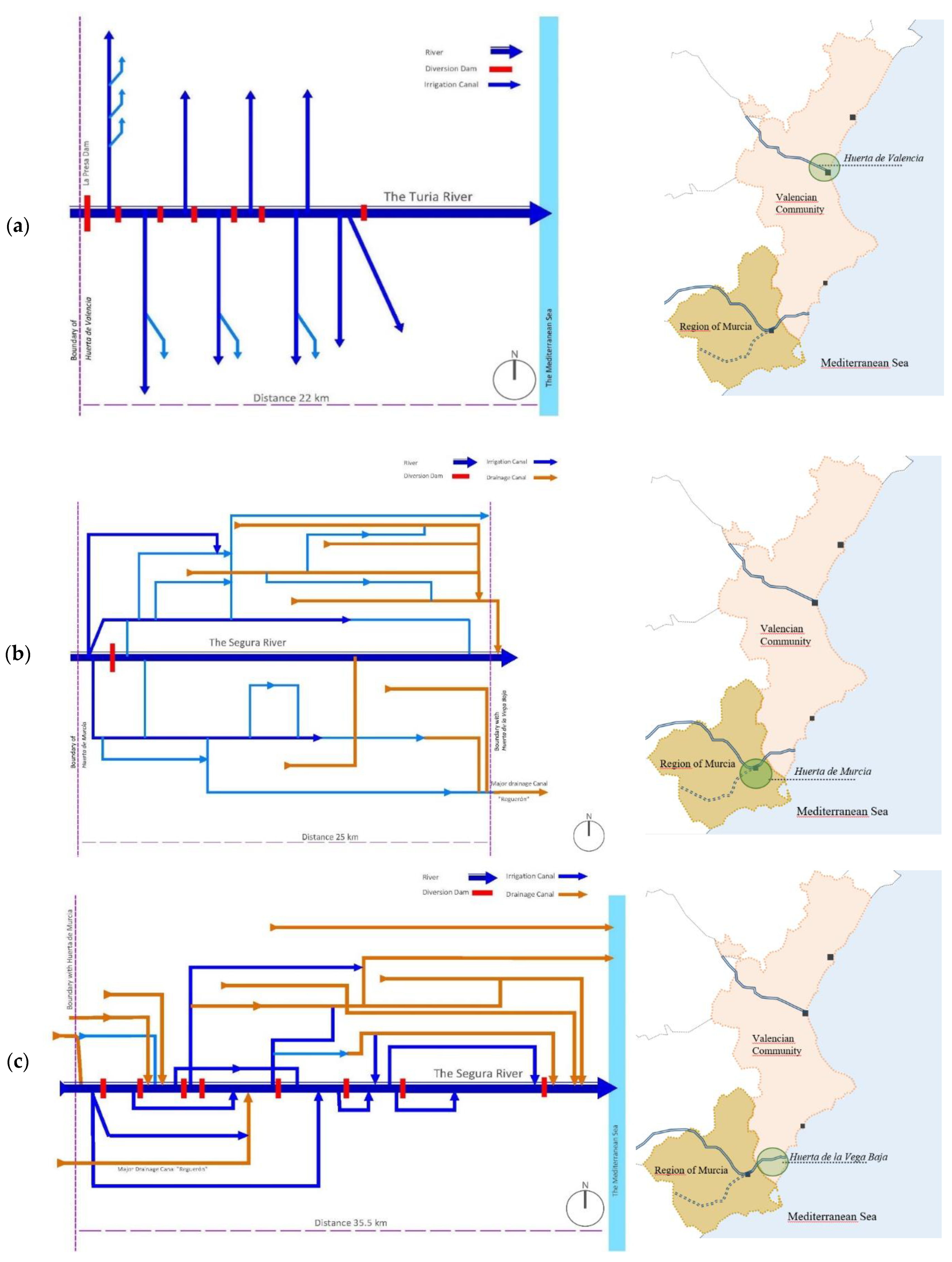
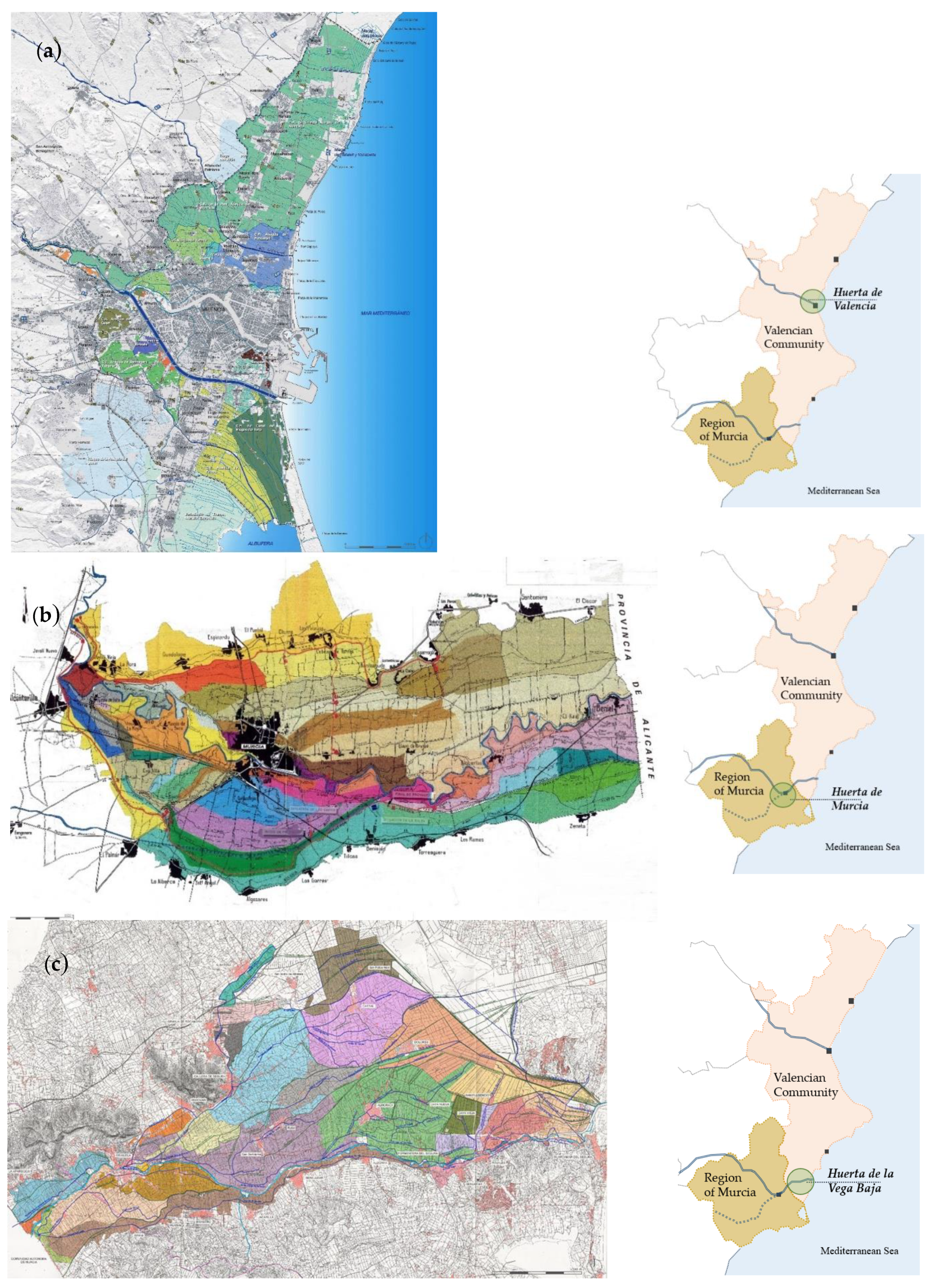
2.1. The Huerta Landscape of Valencia, Murcia, and Vega Baja Territorial Context in Brief

2.1.1. Huerta of Valencia

The alluvial plain of Valencia is situated on the Mediterranean coastline. The Huerta is a strip of irrigated fertile agricultural land, some 33 km in length along the coastal plain, which extends from the border with the municipality of Sagunto in the north to Albal village in the south. The Turia River basin divides this space, and it is the main source for the irrigation framework, in addition to the ravine systems among which the most important ones are the Calderona and Carraixet Ravines in the north, and the Torrent and Catarroja Ravines in the south.
By the middle of the 20th century, an extension of up to 17,000 ha was documented. There are differences between sources, but according to the Valencian Centre for Irrigation Studies at the Polytechnic University of Valencia, presently this Huerta extends some 10,600 ha, comprising the following: the irrigated areas under the stewardship of the “Water Court of the Plain of Valencia”; the Main Royal Canal of Montcada; and a stretch of the Turia channel [28].
The evolution of Valencia City, the regional capital, and the surrounding municipalities, are inseparably linked to the Huerta development [37,38]. Presently, this is the third most populated metropolitan area in Spain with more than 1.7 million inhabitants distributed across 45 municipalities in approximately 62,900 ha [39,40]. It is a very complex spatial context where different administrative entities have overlapped competencies at local, regional, and national levels, ranging from the City Councils of the different municipalities to the Regional Government, as well as the River basin authority, the Jucar Water Authority—Confederación Hidrográfica del Júcar—which belongs to the Spanish National Ministry for Public Works—Ministerio de Fomento. Furthermore, the Huerta of Valencia has been recognised within the Global International Agricultural Heritage Sites—GIAHS—list in 2019 by the Food and Agriculture Organization—FAO—of the United Nations [41].

2.1.2. Huerta of Murcia

The second case study of the Spanish Huerta is situated further south, along the Segura River alluvial plain. The irrigated land is distributed on both sides of the riverbank along 23 km of the river’s middle stretch from the Contraparada Dam inland up to the historical pathway of Vereda del Reino that divided the Kingdoms of Castile and Aragon. Contrasting with the central flatness, this valley’s geographical limits are marked by the southern mountain ranges, Cresta del Gallo and Sierra del Cristo, which together with some prominent hills at the northern borders, Monteagudo or La Sierra de Orihuela, shape the landscape frame.
Historically, the borderline between the aforementioned two ancient kingdoms crossed through this valley and it still remains as an administrative boundary between the provinces of Murcia and Alicante, which belong to different autonomous communities, namely the Murcia Region and the Valencian Community. Over the centuries, this relevant issue has had a deep impact on the subsequent different territorial developments between both sides of the borderline.
This agricultural territory comprises some 10,200 ha in the Murcia Region and is a highly populated zone [42], totalling approximately 500,000 inhabitants [43] distributed among the four main municipalities of the metropolitan area of Murcia City. As in the case of the Huerta de Valencia, the area is under the umbrella of several different administrative entities whose authority rests with the following local, regional, and national government institutions: the four municipalities that govern the local hamlets; the Regional Government of Murcia; and the Segura Water Authority—Confederación Hidrográfica del Segura—which is under the control of the Spanish Ministry for Public Works.

2.1.3. Huerta de la Vega Baja

The third case study is situated downstream from the Segura River. The irrigated land is distributed on both sides of the riverbank along 35 km of the river’s final stretch from the eastern boundary of the Huerta of Murcia, up to the river-mouth on the Mediterranean coast. The central alluvial plain has a 0.2% average slope. This valley is delimited by several foothills in the south and it opens towards the Vinalopó River plain in the north.
This Huerta agricultural territory extends over 23,391 ha [44] and has more than 300,000 inhabitants [43] distributed across 21 municipalities that are situated in the traditional irrigated crop area of Alicante province. In contrast with the adjacent Huerta de Murcia, which is a metropolitan area with a capital city, the Vega Baja is an area with numerous small- and medium-sized urban settlements—ranging from between 5000 inhabitants and 38,000 inhabitants in the largest city, Orihuela—which are spread across the valley and, consequently this territory operates as a polycentric urban network.
The Huerta de la Vega Baja is managed by the previously mentioned administrative entities at local, regional, and national levels, namely the 21 municipalities that govern 50 hamlets; the Government of the Valencian Community; and the Segura Water Authority. These traditional Huerta landscapes have been shaped by their own functional networks and their cultural context. Two categories with integrated features have been identified, namely tangible elements and intangible components.

3. Results. Huerta Landscape: Tangible Elements and Intangible Components

The Huerta landscapes are the identity for local communities. Regarding the physical features that shape the territory, specific tangible elements are highlighted, whereas, in regard to the cultural distinguishing marks intangible components are pinpointed.
The tangible elements involve four interdependent functional networks which are related to the entire Huerta system: (i) the water distribution system as the main force of land transformation, which is an irrigation mesh, with an additional drainage circuitry in the southern Huertas; (ii) the pathways network that determines accessibility and provides mobility; (iii) the settlements that offer shelter; and (iv) the crops that represent the traditional economic activity. The intangible components are an integrated part of the landscape configuration and management involving the following specific norms based on ancestral by-laws and regulations derived from Islamic law and traditions, including the existence of the oldest institutions of justice in Europe: the Water Court of the Plain of Valencia—El Tribunal de las Aguas de la Vega de Valencia; the Council of Wise Men of the Plain of Murcia—El Consejo de Hombres Buenos de Murcia; and the Consuetudinary Exclusive Water Courts—Juzgados Privativos de Aguas. These customary courts are responsible for monitoring the proper application of the Al-Andalus ancient rules—consuetudinary law.
Hence, this landscape is better understood as a “contextual totality defined by the interaction of environmental, social, and cultural processes that give sense to local identity” [6,45,46].

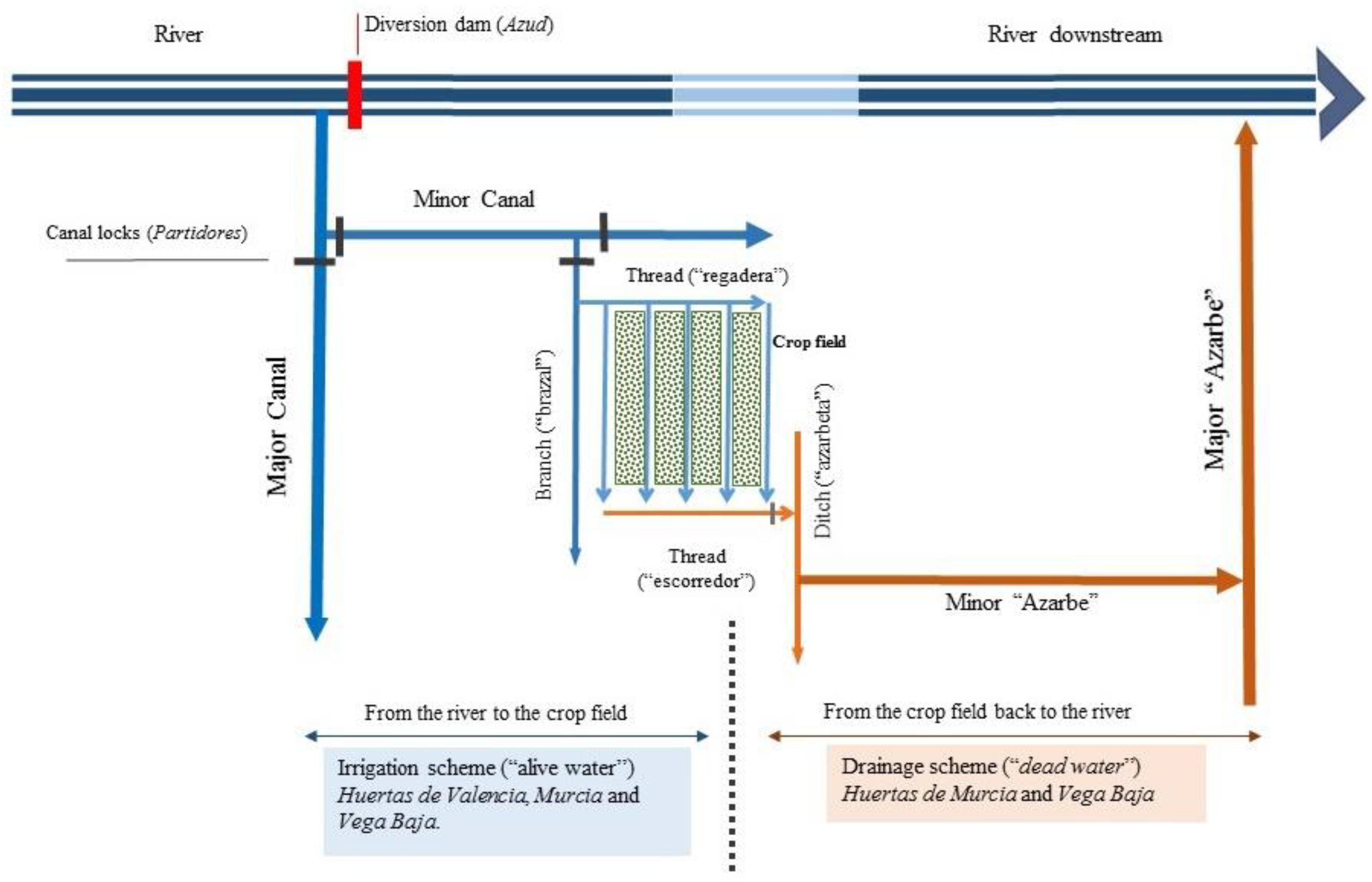
Functional Networks in Huerta Landscape

In this section, the four interdependent functional networks are described, including an outlining of the main features which characterize each Huerta: (i) the water distribution system, the major factor which influences the way the other three basic elements have been managed throughout history; (ii) the pathway network, which follows the water canal tracks; (iii) the analysis of the organization of different settlement patterns and their current context; and (iv) the relationship between the tangible elements—water distribution, the pathway network, and the different settlement patterns—with the agricultural production system. Figure 3 shows a representative image of these Huertas.
  • Water distribution
Much of the irrigation water in the three Huertas was supplied by two river systems: the Turia River in the north and the Segura River in the south. From the Middle Ages, both rivers created an alluvial core area along different stretches and near their river-mouths that became highly cultivated and densely populated Huertas [47,48]. These two rivers have similar characteristics: irregular flow rates with big seasonal differences; main water contribution sources from gullies and ravines during the snow-melting season in mountain areas; and intense seasonal storms that produce floods followed by drought periods. These territories all had swampy wetlands—marjales—most of which were subjected to reclamation processes to be transformed into fertile agricultural land. Despite all these shared characteristics, there are important differences between all three Huerta areas due to their specific geographical conditions, the physical and spatial structure of each territory, and the soil composition.
The water distribution circuitry is the factor that most determines the structural network. Water runs from the mainstream of the river to the field, through a system of river diversion dams—six in Valencia (Figure 4a), one in Murcia (Figure 4b), and eight in Vega Baja (Figure 4c)—from which each Major canal intake feeds the water distribution system comprising 9 main intakes in Valencia, 2 in Murcia and 19 in Vega Baja. It is managed by an effective framework of canal-locks.
The irrigation network is hierarchically organized, and the water flow distribution can be summarized into four levels: Major canal; minor canals, which have their intakes connected to the previous one; branches—brazales—dependent on the minor canals; and threads of water—regaderas—which are the last level and directly irrigate the agricultural plots. The water floods the field to the required level and once the level is reached, the canal is locked, and the water is diverted to irrigate the next cultivated ground. This canal irrigation distribution system is common to all three Huertas (Figure 5, blue single-line scheme)
Due to the specific geomorphological terrain conditions, in the Southern Huertas of Murcia and Vega Baja the unabsorbed irrigation water is drained and reused for subsequent irrigations downstream [33]. However, in Valencia this water is not used again for two reasons relating to the area’s geomorphological features: firstly, the permeable soil facilitates the drainage of water; and secondly, the proximity to the Mediterranean Sea and the Albufera lagoon provides an outlet for the excess water. By contrast, in Murcia and Vega Baja, the distance to the sea—more than 60 km from The Contraparada Dam—as well as the existence of a clayey carbonated lime layer close to the soil surface, provides a high degree of impermeability to the ground which creates standing water and an extensive swamp area. For this reason, a similar network of irrigation was implemented, but with water flowing in the opposite direction, redirecting the excess water back to the river. Again, we find a four-level drainage canal system—”Red de avenamiento” also popularly known as “aguas muertas (dead water)” (Figure 5, orange scheme)—increasing proportionally and in scale from the plots to the Segura River downstream. This cycle is repeated up to eight times along the final 35 km stretch of the Segura River (Huerta de la Vega Baja). Consequently, water is systematically reused. This is a well-balanced network, designed with minimum slope, achieving maximum use of minimum water resources. The irrigation water supplied has an impact, not only on crop watering, but it also recharges the aquifer and finally, the quantity not absorbed is drained back to the river.
This dual circuitry is even more complex in the Huerta de la Vega Baja, where the final stretches of some drainage canals are transformed into an irrigated network, in a last effort to redistribute irrigation water. The complexity of this area can be understood by the number of major canals, which form part of the main network that is 19 Major Irrigation Canals and 31 Major Drainage Canals. In general, the drainage system of these areas is viewed as “man’s contribution to the development of the Huerta just as alluviation has been nature’s” [47].
  • Pathway networks
The pathways network constitutes the second most important territorial structural component. Routes mostly run along the canal banks, which are considered public and therefore have always been left open and unplanted, becoming natural communication arteries [47]. Apart from their evident function, which is providing connectivity between and accessibility to settlements and fields, the path mesh also ensures access to canals and canal locks for water management control and network maintenance [51]. Following the water system structure, pathways also have different widths and receive distinct names in accordance with the hierarchy inherent in the canal network (Figure 5). The exception being the smaller width elements—threads namely “regaderas” and “escorredores”. The interdependency of the water and path networks has fostered the development of settlements in these alluvial plains, thereby enabling the extension of fertile agricultural terrains and avoiding regression to the original marshland. The aforementioned characteristics—system links and path mesh development—are equally relevant to all three Huerta areas studied. Several regulations were in force to ensure the maintenance of the pathway network.
As the pathway network is hierarchically organized and follows the water canal structure, the Murcia and Vega Baja Huerta trail meshes are far more complex than the Valencian one. Their routes are twice as long as those of Murcia and Vega Baja due to the existence of two separate canal systems, one for irrigation and one for drainage. The correlation between the path network (type and width) and the water canal elements (irrigation and drainage networks) derived from the ancient customary law is presented in Table 1.
  • Settlement Patterns
In general, the dynamics of settlement growth in these territories have followed the same patterns for centuries due to the preservation of ancestral methods up to the last decades of the 20th century. This was the result of popular knowledge of environmental conditions as well as the continuity of agriculture as the main economic activity. Territorial organization and town systems have historically relied on irrigation and path meshes, with a distribution based on strategic locations that were protected from floods and occupying the minimum strip of fertile ground [52]. The progressive land occupation in all three Huertas followed specific patterns of settlement typology and distribution, through the following three different territorial occupancy modes: firstly, small villages whose original settlement was initially located on a foothill or a soft hillock, above the general flooding level; secondly, linear hamlets, distributed along the historical paths, whose origin is substandard housing of agricultural labourers; and thirdly, cottages, isolated Huerta houses, situated close to the farmland, occupying slightly elevated topographical levels on privately owned land [30].
During the last 30 years, all settlements have experienced strong growth at an accelerated pace but differently managed: (a) the small villages, now administrative municipalities, elaborated town planning regulations affecting all their territories; (b) the linear hamlets, which are under the administrative control of the small villages, had a process of expansion and/or densification maintaining the linear urban form, with higher quality housing typologies, but bypassing current land planning regulations; (c) the increasing number of isolated Huerta houses or cottages, new or transformed into high-standard villas, are scattered across the agricultural area at the expense of the agricultural plots. Again, these houses are mostly developed by infringing town planning regulations [24,53].
The main differences between the Valencia or Murcia Huerta areas with respect to the Vega Baja territory in terms of land occupancy, density, and urban pressures have been conditioned by the existence of the most important urban centres of Valencia (Figure 6a) and Murcia (Figure 6b). The growth of the city of Valencia has exerted increasing pressure on the traditional cropping fields. The urban growth has contributed to the Huerta’s landscape fragmentation, mainly in specific locations where this growth has become in an urban conurbation between Valencia’s main city and peri-urban towns, now integrated as city neighbourhoods [12,34]. The Huerta de Murcia has undergone a similar process with the reinforcement of the main city as a capital and the urban growth towards the metropolitan peri-urban agricultural context [35,36], generating a kind of “mega blocks” [37] with house alignments which both surrounded and isolated areas of the Huerta [38]. By contrast, the Huerta de la Vega Baja (Figure 6c) is a polycentric town system composed of 21 medium- to small-sized municipalities, which have a network of scattered rural settlements throughout their administrative district. For example, Orihuela is one of the most important towns of the Vega Baja, with 38,000 inhabitants in the main urban centre. It comprises 44 hamlets and villages distributed across its municipal boundaries of the same name [24], as well as numerous detached country houses in the Orihuela Huerta crop area. In the Huerta of Valencia, it is possible to establish a clear distinction between agricultural and residential areas while in Murcia and Vega Baja these two land uses are more mixed.
  • Agricultural Productive System
Historically and up to the present time, the structure of the property is that of a smallholding due to the fertility of the soil cover and the original design of the water irrigation system. Hence, the origin of what looks like a patchwork of plots, forming a dense mosaic that overtime is a changing jigsaw driven by the crop rotation system. The most ancient patterns, at the bottom of the valley, have irregular sizes but straight boundary lines to “facilitate the uniform flow of water” [47] along the water canal network axis. By contrast, new Huerta extensions resulting from the colonization of flooded terrain during the 18th century have a regular quasi rectangular shape [6]. The average size of subsistence agricultural plots in the 14th century ranged from 900 m2 in the Murcia area to 1900 m2 in the area of Vega Baja [54]. Presently, vegetable cropping is more commercially oriented, and the plots range from 5000 m2 to 10,000 m2 [28]. There is also a relationship between crops and plot size. For instance, tree planting tends to be on bigger plots and the smaller ones are generally dedicated to vegetable cultivation.
Differences in the regularity of the flow of water between the Turia and the Segura Rivers determined the nature of the crops on each plain. Furthermore, the nature and distribution of crops in all three areas of Huerta have changed considerably as a result of changing economic pressures over time. The uncertainty of irrigation in the Segura basin has encouraged the alternating practices of extensive and intensive cultivation [54]. However, in the Valencian plain, the development of more intensive cultivation from the outset was possible.
Originally, most of the harvesting were subsistence farming, based on cereals, fodder, and vineyards. Vegetable gardens with a wide variety of crops were situated in the city surroundings, due to their transportation and preservation difficulties. From the middle ages, vegetable crops were dominant within a shifting cultivation system, which resulted in high demand for water and labour. Between the 16th and 18th centuries, mulberry tree groves for supporting the silk industry were very important for the local economy, supplementing incomes for farmers. Hemp and flax were fundamental for rope and sail production, and it was extended during the 18th and 19th centuries. It is from the beginning of the 20th century when there was an important growth of vegetable crops as a predominant agricultural production [28]. This situation was favoured by two factors: better accessibility which reduced the distribution time of fresh produce; and improved conservation techniques. The changing circumstances from the 1950s with the progressive introduction of citrus groves, mainly orange trees, required less labour and produced a greater crop yield, gradually displacing vegetable fields for orchards [4].
These facts brought about several changes, one of them is the way the Huerta landscape is perceived, not only from the economical or productive point of view but also from Huerta’s landscape identity and perception. The classic crop shifting related to the soil characteristics and seasonal changes is no more the prevalent image of these Huertas; in its place, treetops provide a static image rather than the traditional rural scene of people working in the field.
  • Immaterial heritage: Management of water, the strongest community link
The Huerta landscape encompasses, beyond the aforementioned physical features, several immaterial heritage hallmarks: the use of the term Huerta; water distribution regulations; responsibility for the upkeep of canals and paths; and a specific oral tribunal for the settlement of disputes. The Huerta’s immaterial features have different ancient origins, such as the Babylonian Code of Hamurabi, the Islamic law —Malikite law— and the Christian Al-Andalus tradition”.
[47]
Huerta as the proper noun. The first element that should be highlighted is the use of the term Huerta itself. Geographers characterize Huertas by their physical features: red alluvial soil, containing between 2% and 4% of iron and a very superficial phreatic level [47]. However, this denomination does not refer to any irrigated area along the Mediterranean coastal plains. Rather, it is specifically linked to the historical agricultural areas which correspond to a model originally developed during medieval times. In addition, the term Huerta is always attached to its toponymical reference linked to the following factors, among others: the city to which it belongs, Huerta de Orihuela, Huerta de Murcia; specific areas or physical characteristics of the landscape, El Brazal de la Olivera—The Olive Tree Water Branch—or Cabecico Verde—Green Small Hillock—linked to scenery landmarks; or the family name of the original landowners such as Los Miretes or Los Ramos. Consequently, from the local perspective, the name is always linked to place identity, which in turn introduces its cultural nuances.
Water management. The regulation of water distribution was based on the agriculture surface area and the type of crop. Due to the scarcity of water, the regulation of the available quantity of water for each plot was established by custom and controlled by local irrigation communities linked to each Major Canal with a system supported by the community [55]. As the amount of water available could not be foreseen, the regulation was always established in terms of the allowable duration of the irrigation period and was adapted to the seasonal water supply. This time unit is named hila and represents one share of the total amount of water in a given river—or stretch of a river—spring, or canal. The equivalence of each hila in hours for the different alluvial planes was deduced by Glick. The right to water is inherent to the land itself, and the ancient medieval law entitled the land itself to a quantity of canal water in proportion to the size of a worked plot. All irrigated fields had at least one canal which constituted the plot boundaries and often also the boundary between properties [47]. There were several corrective measures for watering time driven by seasonal variations in water supply, ground slope irregularities between plots, and essential crop irrigation priorities.
The establishment and control of water resources and the canal network were administered by the Irrigation Communities, namely the group of landowners irrigating from a single major canal. The role of these partnerships is managing, organizing, and distributing water irrigation flows [56]. The geographical distribution of these communities has determined not only the agricultural production of the Huerta but also the essential structure of the territorial organization and community social relationships.
In the irrigated area of the Plain of Valencia, 10 main irrigation communities exist—Rovella, Favara, Mislata, Xirivella, Quart, Benàger-Faitanar, Mestalla, Rascanya, Tormos, and Montcada—and two small communities—Manises and Aldaia—bringing the total to 12 communities [57] (Figure 7a). In the Huerta de Murcia (Figure 7b), there is only one Irrigation Community—Junta de Hacendados de la Huerta de Murcia—with jurisdiction over two major canals, but it is managed through 71 smaller irrigation communities, namely heredamientos [44]. Finally, the Vega Baja area is managed by 26 Irrigation Communities with different names including Comunidades de Regantes, Juzgados Privativos de Aguas, and Sindicatos de riego. All of them refer to the same autonomous organizations that have a common approach to managing and agreeing on decisions related to water administration [45] (Figure 7c).
Canal and path upkeep rules. The water canal systems required continuous maintenance and reparation works at canals, canal locks, and dams, which, in turn, also affected the path networks. Canal and path upkeep rules were first established by the Muslims in the VIII Century and assumed by Christian Kings after the Reconquest.
These by-laws described the rights and duties of landowners and established the penalties in the case of a breach. The need to maintain optimal conditions for the crop production system—water canal network, paths mesh, and crop plots—requires a regulatory framework, as well as monitoring through specific officers in charge to verify compliance, namely cequiers or sobrecequiers for the irrigation system and mustasaf for the roads system.
Silt and mud deposition by river water made it necessary to clean up and reshape the canal system. The removed mud was used to consolidate canal walls or widen the path’s running surface. The importance of complying with these obligations can be illustrated through an example of penalties decree, by King James I, establishing a fine of five sous—the ancient Catalonian coin—or the consideration of the Fathers of Murcia as a contemptible action [47]. This concept of the individual’s responsibility is related to water use, willingness to submit a turn, and liability for damages caused to neighbours was introduced as customary in line with Koranic law [55]. This need for cooperation is clearly explained by Glick as follows: “An irrigation system establishes relationships among individuals and groups which are simultaneously relationships of interdependence and potential antagonism, stemming equally from the need for and the constraint imposed by cooperation and coordination. The necessity for an ordered, predictable system of water allocation has divisive as well as cohesive potentialities” [47].
The administration of these territories. The administrative decision relating to territorial disputes about irrigation and water management was, and continues to be, under the jurisdiction of specific courts which have the responsibility of monitoring the proper application of regulatory rules. Each irrigation community, as a single entity or grouped, has the legal right to constitute an arbitration tribunal and these courts are one of the oldest democratic institutions in Europe. Their judicial decisions are settled orally in a swift manner and some researchers link the origin of these institutions to the primeval Islamic council of elders or sura [55]. The unanimous respect for decisions taken by these tribunals among all members of the communities has provided cohesion and identity to local inhabitants, as well as a resilient and meaningful territorial framework [12].
The tribunals are organised into two different types of courts. Firstly, an autonomous institution of Justice whose judgement is final, the case for the two larger Valencian and Murcian jurisdictions. In Valencia, The Water Tribunal of the plain of Valencia—Tribunal de las Aguas de Valencia—has jurisdiction over 11,691 landowners. In Murcia, the Council of Wise Men of the plain of Murcia—Consejo de los Hombres Buenos de Murcia—has jurisdiction over 23,313 landowners. Both tribunals have been included in the Representative List of the Intangible Cultural Heritage of Humanity by UNESCO as an emblematic representation of irrigators’ tribunals in the Spanish Mediterranean area [58].
The second type of administrative institution is the Irrigation Community Court, whose decisions can be appealed to the Spanish Court system, which is the case for the remaining smaller communities. These Irrigation Community Courts, like those existing in the Vega Baja plain, have the same function of solving their internal conflicts among landowners.

4. Discussion

The complexity of the Huerta landscape systems lies in the extreme environmental conditions together with the geomorphologic characteristics of the areas where are located. The systemic scarcity of water alternating with flooding episodes is something endemic since the Huertas’ inception. The balance between the structural tangible elements related to the functional networks—water distribution and drainage, pathway networks, settlement patterns, and agricultural crops—and the intangible components—cultural and administrative features—have built up a highly productive landscape which, in turn, represents the identity of these territories: Valencia, Murcia, and Vega Baja. Table 2 summarises the correlation between Tangible elements and Intangible components, briefly showing the complexity of the primeval relationships between these features.
The correlation between elements and components shows the complexity of the system interrelating social cohesion and community trust with the physical organization of the landscape and resources management. In this sense, one of the most relevant features of these landscapes of Huerta is the balanced and meaningful link between local society and land management. Thus, its weakening entails undermining the resilience of the Huerta landscape.
All three Huertas are under intense pressure from urban developments, new infrastructures [38,60]. The metropolitan area of Valencia comprises 45 municipalities and is the third biggest area in Spain with 1,748,142 inhabitants; Murcia metropolitan area is almost a conurbation of 11 municipalities that gathers 637,616 inhabitants; finally, the Vega Baja del Segura area comprises 27 municipalities divided into several medium and small scattered settlements with a total population of approximately 355,257 inhabitants. This last case study is under increasing pressure from tourism and second residence developments [43].
Due to the above territorial context, it is clear to see that any urban development has been implemented at the expense of the Huerta plots. It is estimated that between 1956 and 2011—50 years—the Huerta of Valencia has reduced the total agricultural surface by two thirds [61]. Regarding the Huerta of Murcia, a study from the University of Murcia, the agricultural surface has been reduced by 41% in 78 years [18,32]. In relation to the Huerta de la Vega Baja, analysing data between 1990 and 2006 land occupancy tripled [24]. So, urban dynamics have deeply affected the landscape and land uses within the metropolitan areas, mainly in the peri-urban fringe [14]. Additionally, new water market dynamics are being introduced by government institutions in an attempt to balance the structural problem related to water [62,63]. However, the transformation of these Huertas has a significantly amplified negative effect in the complete system of knitted structural tangible elements with the repercussion of the intangible components.
At the same time, it should be pointed out that the local public administrations have developed different territorial plans in order to manage and protect these Huertas values. This fact has produced different scenarios in each case: Huerta de Valencia has a specific territorial plan for its protection as a whole [28]; Huerta de Murcia has partial protections of different elements related to the cultural heritage mainly included in the City of Murcia’s urban plan [64]; and, finally, for Huerta de la Vega Baja there are still no specific plans at the moment. This is particularly striking considering the uniqueness and the strategic significance in the territorial identity of these areas shown through this study.
As highlighted by Arnés García et al., agricultural European heritage is gaining momentum as sustainable systems, adaptative traditional techniques with high resilience, and linked to local traditional knowledge, which preserve valuable cultural heritage. Consequently, their recognition in the FAO GIAHS’ list is the first step to focus on disclosing their importance [65,66]. Moreover, perceived as multifunctional systems [67], these Huertas have proven to be a highly appreciated environmental and productive asset which, in turn, converge within the European directives about land uses considering them as an opportunity for the development of green infrastructure goals and natural flood management [68,69], or, as territorial multi-scalar connectors between urban settlements and Natura 2000 sites network, thus, providing landscape connectivity and contributing to improve an ecosystem services framework [70,71]. Further research could usefully explore more closely these questions and constitute future research directions to be developed.

5. Conclusions

The analysis of three Spanish Huerta agricultural landscapes demonstrates that the Huerta constitutes a complex system which builds specific landscape features but also provides environmental solutions in extreme climate conditions. Thus, revealing its continued uniqueness. This affirmation concurs with previously cited authors such as the comprehensive historical studies carried out by T.F. Glick and the contemporary identification of agricultural European landscapes put forward by J.H.A. Meeus, M.P. Wijermans, and M.J. Vroom. These characteristics comprise tangible elements related to physical features and intangible components related to customs or habits. They are inextricably linked, as demonstrated by the ancient water management procedures and form an integrated part of the characteristics that shape each of the three Huerta landscape’s studied.
The Huerta de Valencia surrounds the largest settlement—Valencia—and extends across 45 neighbouring municipalities that have generated a considerable degree of urban pressure, resulting in the fragmentation and reduction of the Huerta surface area. The irrigation system is simple without drainage canals and its management is centralized.
The Huerta de Murcia, as in the Valencia case, is the main landscape system surrounding Murcia’s metropolitan area and extends across four municipalities. The water distribution system, despite having only one diversion dam with two intakes of water, is complex with a double canal network—irrigation and drainage canals. There is high reuse of water up to three times in different plots. From an administrative perspective, the management is centralized.
The Huerta de la Vega Baja is related to a totally different settlement system compared to the previous Huerta cases. This is poly-nuclear urbanization of the territory with middle and small-sized cities, rather than a single metropolis. The Huerta de la Vega Baja system is the largest and most complex case of the three Huertas. Firstly, it has the highest number of diversion dams. Secondly, the irrigation and drainage canal networks are the widest, creating a labyrinth-like water network. This complexity in the territorial configuration is also demonstrated by the fact that the water distribution is managed by 13 irrigation communities.
In short, the Huerta de Valencia is a fragmented territory with centralized management, the Huerta de Murcia is characterized by a centralized territory and water management, and the Huerta de la Vega Baja is a polynuclear territory with decentralized water management.
The integration of two approaches—material elements and immaterial components—has greatly facilitated the recognition of each Huerta’s distinctive features. The three Huertas analysed through two approaches reinforce the existence of one specific recognizable landscape that brings together place, society, and culture.
The Huerta territories are highly productive agricultural areas whose specific territorial conditions make them strategically suitable for arising UPUA objectives. Despite having lost prominence in the local economy, nevertheless, the importance of agricultural activities remains a backbone at the domestic level and the agricultural landscape pattern constitutes the identity for local communities. Even with the serious setback for the productive hectares of fertile land suffered during the last decades, their extension and links with settlements make them a tactical asset for reaching UPUA objectives.

Author Contributions

Both authors have contributed to the conceptualization, methodology, formal analysis, writing—original draft preparation, review, and editing: P.M. and C.G.-M. All authors have read and agreed to the published version of the manuscript.

Funding

This research received no external funding.

Conflicts of Interest

The authors declare no conflict of interest.

References

  1. Meeus, J.; Wijermans, M.; Vroom, M. Agricultural landscapes in Europe and their transformation. Landsc. Urban Plan. 1990, 18, 289–352. [Google Scholar] [CrossRef]
  2. European Environment Agency. Europe’s Environment—The Dobris Assessment; European Environment Agency: Copenhague, Denmark, 1995. [Google Scholar]
  3. Malek, Ž.; Verburg, P.H. Mediterranean land systems: Representing diversity and intensity of complex land systems in a dynamic region. Landsc. Urban Plan. 2017, 165, 102–116. [Google Scholar] [CrossRef] [Green Version]
  4. García-Marín, R.; Espejo-Marín, C.; Giménez-García, R.; Ruiz-Álvarez, V. Transformations in the Agricultural and Scenic Landscapes in the Northwest of the Region of Murcia (Spain): Moving towards Long Awaited (Un)Sustainability. Land 2020, 9, 314. [Google Scholar] [CrossRef]
  5. El Paisaje: Valores e Identidades; Martínez de Pisón, E.; Ortega Cantero, N. (Eds.) Ediciones de la Universidad Autónoma de Madrid, Fundación Duques de Soria: Madrid, Spain, 2009; ISBN 9788483441541. [Google Scholar]
  6. Olmo, R.M.; Muñoz, S.F. La Huerta de Murcia: Landscape guidelines for a peri-urban territory. Landsc. Res. 2004, 29, 385–397. [Google Scholar] [CrossRef]
  7. Vallés-Planells, M.; Galiana, F.; Torrijos, I.D. Agricultural abandonment and resilience in a Mediterranean periurban traditional agroecosystem: A landscape approach. Ecol. Soc. 2020, 25, 25. [Google Scholar] [CrossRef] [Green Version]
  8. Olmo, R.M. Agricultura, paisaje y gestión del territorio. Polígonos Rev. Geogr. 2012, 14, 97. [Google Scholar] [CrossRef]
  9. European Environment Agency. Urban Sprawl in Europe: The Ignored Challenge; Publications Office of the European Communities: Luxembourg, 2006. [Google Scholar]
  10. Antrop, M. Why landscapes of the past are important for the future. Landsc. Urban Plan. 2005, 70, 21–34. [Google Scholar] [CrossRef]
  11. Pumain, D. La cuestión de las ciudades en la ordenación del territorio europeo. Urban 2003, 8, 8–18. [Google Scholar]
  12. Cumming, G.S.; Olsson, P.; Chapin, F.S.; Holling, C.S. Resilience, experimentation, and scale mismatches in social-ecological landscapes. Landsc. Ecol. 2013, 28, 1139–1150. [Google Scholar] [CrossRef]
  13. Cumming, G.S. Spatial resilience: Integrating landscape ecology, resilience, and sustainability. Landsc. Ecol. 2011, 26, 899–909. [Google Scholar] [CrossRef]
  14. Shaw, B.J.; Van Vliet, J.; Verburg, P.H. The peri-urbanization of Europe: A systematic review of a multifaceted process. Landsc. Urban Plan. 2020, 196, 103733. [Google Scholar] [CrossRef]
  15. Piorr, A.; Zasada, I.; Doernberg, A.; Zoll, F.; Ramme, W. Research for AGRI Committee-Urban and Peri-Urban Agriculture in the EU; European Parliament, Policy Department for Structural and Cohesion Policies: Brussels, Belgium, 2018; ISBN 9789284629534. [Google Scholar]
  16. Membrado-Tena, J.C.; García, E.I. Analysis of place names in l’horta de valència (Spain). Integration of the classical and the critical approaches for the reconstruction and enhancement of its landscape. Doc. d’Analisi Geogr. 2018, 64, 247–269. [Google Scholar]
  17. Torreggiani, D.; Ludwiczak, Z.; Dall’Ara, E.; Benni, S.; Maino, E.; Tassinari, P. TRuLAn: A high-resolution method for multi-time analysis of traditional rural landscapes and its application in Emilia-Romagna, Italy. Landsc. Urban Plan. 2014, 124, 93–103. [Google Scholar] [CrossRef]
  18. Martínez-Paz, J.M.; Banos-González, I.; Martínez-Fernández, J.; Esteve-Selma, M.-Á. Assessment of management measures for the conservation of traditional irrigated lands: The case of the Huerta of Murcia (Spain). Land Use Policy 2019, 81, 382–391. [Google Scholar] [CrossRef]
  19. Mata Olmo, R.; Fernández Muñoz, S. Paisajes y patrimonios culturales del agua. La salvaguarda del valor patrimonial de los regadíos tradicionales. Scr. Nov. 2010, 14, 1–9. [Google Scholar]
  20. Marques-Perez, I.; Segura, B. Integrating social preferences analysis for multifunctional peri-urban farming in planning. An application by multi-criteria analysis techniques and stakeholders. Agroecol. Sustain. Food Syst. 2018, 42, 1029–1057. [Google Scholar] [CrossRef]
  21. García-Ayllón, S. Predictive Diagnosis of Agricultural Periurban Areas Based on Territorial Indicators: Comparative Landscape Trends of the So-Called “Orchard of Europe”. Sustainability 2018, 10, 1820. [Google Scholar] [CrossRef] [Green Version]
  22. Martínez-Fernández, J.; Esteve-Selma, M.-Á.; Banos-González, I.; Carreño, M.F.; Moreno, Á. Sustainability of Mediterranean irrigated agro-landscapes. Ecol. Model. 2013, 248, 11–19. [Google Scholar] [CrossRef]
  23. Pérez-Campaña, R. Vegas and Deltas in the Vicinity of Medium-Sized Cities in Andalucia, Spain: Landscapes under Pressure but Scarcely Considered in Planning. Eur. Plan. Stud. 2015, 23, 1209–1227. [Google Scholar] [CrossRef]
  24. García-Mayor, C. Invariants in the evolution and territorial identity of the traditional Huerta landscape of the Vega Baja of the Segura River: 1929–2010. Bol. Asoc. Geogr. Esp. 2017, 2017, 369–388. [Google Scholar]
  25. Ros Sempere, M.; García Martín, F.M. Cinco Palmos, 1929–2015: Transformación de Usos del Suelo en la Huerta de Murcia; CRAI Biblioteca, Universidad Politécnica de Cartagena: Murcia, Spain, 2016; ISBN 9788416325238. [Google Scholar]
  26. Urteaga, L.; Nadal, F.; Muro, J.I. Los mapas de España del Army Map Service, 1941–1953. Ería Rev. Cuatrimest. Geogr. 2000, 51, 31–43. [Google Scholar]
  27. Canales Martinez, G.; Garcia-Mayor, C.; Gea Calatayud, M.; Diz Ardid, E. La Huerta del Bajo Segura: Evolución del Regadío Tradicional; University of Alicante: Alicante, Spain, 2017; ISBN 9788416724673. [Google Scholar]
  28. Generalitat Valenciana. Plan de Acción Territorial de Protección de la Huerta de Valencia; Consellería d’Habitatge, Obres Públiques i Vertebració del Terrtiori: Valencia, Spain, 2010; Available online: http://politicaterritorial.gva.es/es/web/planificacion-territorial-e-infraestructura-verde/pat-horta-de-valencia (accessed on 19 February 2020).
  29. Instituto Geográfico Nacional Base Topográfica Nacional de España. Available online: https://www.ign.es/web/cbg-area-cartografia (accessed on 19 February 2020).
  30. Martínez, C.; Rodríguez, G.C.; Fermín Salazar Vives, J.; López, G.; Ferrando, J.D.P.; Salvador Segrelles, J.A.; Bonmatí Antón, J.F. Territorio y urbanismo en el Bajo Segura. Alquibla 1995, 1, 173–204. [Google Scholar]
  31. Muñoz-Criado, A. Plan de la Huerta de Valencia: Un Paisaje Cultural Milenario; Gestión, E.P., Valenciana, G., Eds.; Conselleria de Medi Ambient, Aigua, Urbanisme i Habitatge: Valencia, Spain, 2009; Volume 1, ISBN 978-84-482-5326-4. [Google Scholar]
  32. García Martín, F.M. Dinámicas de Crecimiento de la Huerta de Murcia y Similitudes con el Véneto Italiano. In Proceedings of the V Jornadas de Introducción a la Investigación de la UPCT, Murcia, Spain, 20 April 2012; pp. 21–23. [Google Scholar]
  33. Canales Martínez, G. La Huerta del Bajo Segura, Paradigma de la Cultura del Agua. In Patrimonio Hidráulico y Cultura del Agua en el Mediterráneo; Gómez Espín, J.M., Hervás Avilés, R.M., Eds.; Fundación Séneca, Regional Campus of International Excellence «Campus Mare Nostrum», Agencia Española de Cooperación Internacional para el Desarrollo: Madrid, Spain, 2012; pp. 265–287. ISBN 9788469539095. Available online: http://hdl.handle.net/10045/25889 (accessed on 19 February 2020).
  34. Ponce Sánchez, M.D. Percepción de los procesos de urbanización y pérdida de paisajes identitarios en la Vega del Río Segura. In Proceedings of the Urbanismo Expansivo: Dela Utopía a la Realidad. XXII Congreso de la Asociación de Geógrafos Españoles, Alicante, Spain, 27–29 October 2011; Gozálvez Pérez, V., Marco Molina, J.A., Eds.; Asociación de Geógrafos Españoles: Alicante, Spain, 2011; pp. 555–566. [Google Scholar]
  35. Plan Nacional de Ortofotografía Aérea. Available online: https://pnoa.ign.es/ (accessed on 19 February 2020).
  36. Valenciana, G. Instituto Cartográfico Valenciano Cartoweb. Visor Cartográfico. Available online: https://visor.gva.es/visor/ (accessed on 15 March 2020).
  37. Miralles Garcia, J.L. The Planning of Peri-Urban Agricultural Areas: The Case of “L’Horta de València”. In Proceedings of the REAL CORP 2013: Planning Times, Roma Italy, 20–23 May 2013; Schrenk, M., Popovich, V.V., Zeile, P., Elisei, P., Eds.; CORP—Competence Center of Urban and Regional Planning: Schwechat, Austria, 2013; pp. 953–962. [Google Scholar]
  38. Argyelan, T.; Torrijos, I.D.; Planells, M.V.; Galán, F.G. Land use change in Huerta de Valencia (2008–2013). Resilience and cultural landscapes. Irrig. Soc. Landsc. Tribut. Thomas F. Glick 2014, 1–14. [Google Scholar] [CrossRef]
  39. Ministerio de Fomento Átlas Estadístico de las Áreas Urbanas—Atlas Estadístico de las Áreas Urbanas—Portal del Suelo y Politicas Urbanas. Available online: https://m.fomento.gob.es/mfom/lang_castellano/_especiales/siu/atlas/default.htm (accessed on 9 September 2020).
  40. Generalitat Valenciana Plan de Infraestructura Verde y Paisaje de la Comunitat Valenciana. Available online: http://www.upv.es/contenidos/CAMUNISO/info/778623normalc.html (accessed on 18 January 2019).
  41. United Nations FAO—News Article: Spain’s Horta of Valencia Wins Recognition on FAO’s Global Agricultural Heritage List. Available online: http://www.fao.org/news/story/en/item/1252906/icode/ (accessed on 22 October 2020).
  42. Región de Murcia Proyecto OSDDT-MED. Modelo de Ocupación Territorial en la Huerta de Murcia. Available online: http://ww.osddt.eu/es/resultados (accessed on 9 September 2020).
  43. Instituto Nacional de Estadística (INE). Actualización de Rentas Con el IPC General (Sistema IPC Base 2016); Ministerio de Economía, Industria y Competitividad: Madrid, Spain; Available online: http://www.ine.es/ (accessed on 9 September 2020).
  44. Confederación Hidrográfica del Segura. Plan Hidrológico de la Cuenca del Segura. 2015–2021; Ministerio de Agricultura, Alimentación y Medio Ambiente, Demarcación Hidrográfica del Segura: Madrid, Spain, 2015. [Google Scholar]
  45. Clementi, A. Interpretazioni di Paessagio: Convezione Europea e Innovazioni di Metodo; Meltemi Editori: Roma, Italy, 2002; ISBN 9788883531736. [Google Scholar]
  46. Hermosilla Pla, J. Contexto geográfico e histórico de los regadíos de la Huerta de Valencia. In El Patrimonio Hidraúlico del Bajo Turia: L’Horta de Valencia; Valenciana, Ministerio para la Transición Ecológica, Confederación Hidrográfica del Júcar: Valencia, Spain, 2007; Volume 9, p. 182. ISBN 978-84-482-4802-4. [Google Scholar]
  47. Glick, T.F. Irrigation and Society in Medieval Valencia; Harvard University Press: Cambridge, MA, USA, 2013. [Google Scholar]
  48. Guinot Rodríguez, E. El paisaje de la huerta de Valencia: Elementos de interpretación de su morfología espacial de origen medieval—Dialnet. In Historia de la Ciudad. V: Tradición y Progreso; Colegio Oficial de Arquitectos de la Comunidad Valenciana: Valencia, Spain, 2008; pp. 115–129. ISBN 978-84-86828-80-6. [Google Scholar]
  49. Confederación Hidrográfica del Segura—CHS. Áreas de Riego de Murcia. Proyecto de Modernización de los Regadíos de la Vega Media del Segura; Ministerio de Agricultura, Alimentación y Medio Ambiente, Demarcación Hidrográfica del Segura: Murcia, Spain, 1993. [Google Scholar]
  50. Darder García, F.J. Sanchís Ibor, C. Comunidades de Riego de la Vega Baja del Segura; Centro Valenciano de Estudios del Riego, Universidad Politécnica de Valencia, Juzgado Privativo de Aguas de Orihuela: Alicante, Spain, 2002. [Google Scholar]
  51. García Mayor, C.; Canales Martínez, G. La Huerta de Orihuela en el Bajo Segura: Elementos Funcionales en la Configuración del Paisaje; Universidad de Alicante, Ed.; Universitat d’Alacant-Universidad de Alicante: Alicante, Spain, 2015; ISBN 9788497173735. [Google Scholar]
  52. Ciriquián, P.M.; Mayor, C.G.; Cirugeda, A.N. Transformación urbana, espacio público y su percepción social. El río Segura a su paso por Orihuela y Rojales. Polígonos Rev. Geogr. 2014, 185–214. [Google Scholar] [CrossRef] [Green Version]
  53. Marcos, A.; Sempere, R. Huerta de Murcia: Etapas, Patrones de Transformación y Causas. In Proceedings of the 11th Congreso Nacional del Medio Ambiente, Madrid, Spain, 26–30 November 2012; p. 27. [Google Scholar]
  54. Calvo García-Torner, F. La formación del paisaje agrario de la Huerta de Murcia. Rev. Geogr. 1972, 6, 5–33. [Google Scholar]
  55. Martínez Martínez, M. El poder y la justicia del agua en la Murcia medieval: El Consejo de Hombres Buenos—Dialnet. Cuad. Hist. España 2011, 85–86, 459–466. [Google Scholar]
  56. Melgarejo Moreno, J.; Trapote Jaune, A.; Roca Roca, F.J. Hydraulic Infrastructure and water management in the traditional irrigation system in the Vega Baja del Segura (Alicante). Pilquen-Sección Agron. 2013, XV, 3–20. [Google Scholar]
  57. Tribunal de las Aguas Tribunal de las Aguas de la Vega de Valencia—El Tribunal. Available online: https://tribunaldelasaguas.org/es/ (accessed on 9 September 2020).
  58. UNESCO. Representative List of the Intangible Cultural Heritage of Humanity; UNESCO, Sector for Culture: Paris, France, 2009. [Google Scholar]
  59. López Ortiz, M.I.; Melgarejo Moreno, J. El fin del regadío tradicional y la creación de sociedades mercantiles para la venta del agua. Riegos de Levante margen derecha del Segura. Bol. Asoc. Geogr. Esp. 2007, 43, 28. [Google Scholar]
  60. Romero, J. Spanish Mediterranean Huertas: Theory and reality in the planning and management of peri-urban agriculture and cultural landscapes. Sustain. Dev. Plan. VII 2015, 193, 585–595. [Google Scholar] [CrossRef] [Green Version]
  61. Soriano i Piqueras, V. La Huerta de Valencia: Un Paisaje Menguante; Soriano i Piqueras, V., Ed.; CreateSpace Independent Publishing Platform: Valencia, Spain, 2015; ISBN 978-1512009231. [Google Scholar]
  62. Calatrava, J.; Martinez-Granados, D. The limited success of formal water markets in the Segura River basin, Spain. Int. J. Water Resour. Dev. 2017, 34, 961–981. [Google Scholar] [CrossRef]
  63. Grindlay, A.; Zamorano, M.; Rodríguez, M.; Molero, E.; Urrea, M. Implementation of the European Water Framework Directive: Integration of hydrological and regional planning at the Segura River Basin, southeast Spain. Land Use Policy 2011, 28, 242–256. [Google Scholar] [CrossRef]
  64. García Martín, F.M. La protección del paisaje cultural de la Huerta de Murcia por el Plan General de Ordenación Urbana. In Proceedings of the XXII Jornadas Patrimonio Cultural Región Murcia, Murcia, Spain, 4–8 November 2011; pp. 323–332, ISBN 978-84-7564-595-7. [Google Scholar]
  65. Ochoa, C.Y.; Jiménez, D.F.; Olmo, R.M. Green Infrastructure Planning in Metropolitan Regions to Improve the Connectivity of Agricultural Landscapes and Food Security. Land 2020, 9, 414. [Google Scholar] [CrossRef]
  66. García, M.A.; Yagüe, J.; De Nicolás, V.L.; Díaz-Puente, J. Characterization of Globally Important Agricultural Heritage Systems (GIAHS) in Europe. Sustainability 2020, 12, 1611. [Google Scholar] [CrossRef] [Green Version]
  67. Ives, C.D.; Kendal, D. Values and attitudes of the urban public towards peri-urban agricultural land. Land Use Policy 2013, 34, 80–90. [Google Scholar] [CrossRef]
  68. Cantó López, T. Green Infrastructure management in the southeast Iberian (Valencian Community, Spain). Cuad. Biodivers. 2014, 45, 10–22. [Google Scholar]
  69. European Commission (EC). Flood Risk Management—Water—Environment—European Commission. Available online: https://ec.europa.eu/environment/water/flood_risk/ (accessed on 11 September 2020).
  70. MITECO Red Natura 2000 (RN2000). Available online: https://www.miteco.gob.es/es/cartografia-y-sig/ide/descargas/biodiversidad/rn2000.aspx (accessed on 30 August 2020).
  71. Institute of European Policy. Economic Benefits of the Natura 2000 Network; European Commission (EC), Ed.; Publications Office of the European Union: Luxembourg, 2013; ISBN 9789279275883. [Google Scholar]
Figure 1. (a) Agricultural landscapes in Europe [1] (p.298); (b) Dobris Report map for European Landscapes, based on Meeus et al. map [2]. Note that Huerta locations are highlighted in dark-red shaded spots.
Land 09 00460 g001
Figure 2. Location map. Regional context and main river courses related to Huerta case studies.
Land 09 00460 g002
Figure 3. Agricultural plots in the floodplain contrasting with nude rock mountain in the Huerta de la Vega Baja. Author: J. Ruiz.
Land 09 00460 g003
Figure 4. Schematic diagrams of the water distribution circuitry in each of the Huerta territories. (a) Huerta de Valencia in the final stretch of the Turia River. Diagram based on PAT Huerta de Valencia documents [28]. (b) Huerta de Murcia, at the Segura River’s middle course, between the Contraparada Dam and the boundary with the province of Alicante. Diagram based on Segura Water Authority documents [49]. (c) Huerta de la Vega Baja, from the Murcia boundary to the river mouth at the Mediterranean Sea. Diagram based on Segura Water Authority documents [50]. Red markers represent the diversion dams along the river courses. Diagrams not to scale.
Land 09 00460 g004
Figure 5. Water distribution circuitry scheme. Left (blue) irrigation canals, water diverted from the river to the fields. Right (orange) drainage canals, exceeding irrigation water redirected towards the river. Source: Authors. Diagram based on water regulation documents. Not to scale.
Land 09 00460 g005
Figure 6. Settlement network and land occupation in the three Huertas territories. (a) Huerta de Valencia. (b) Huerta de Murcia. (c) Huerta de la Vega Baja. Source: Adapted from the National Geographic Institute of Spain [29].
Land 09 00460 g006
Figure 7. Irrigation Communities in each Huerta territories. (a) Huerta de Valencia. Each colour represents an irrigation community related to a Major Canal [28]; (b) Huerta de Murcia. Breakdown of the Irrigation Community into the smaller irrigation management areas as indicated by map colouring [49]; (c) Irrigation Communities of Huerta de la Vega Baja [59].
Land 09 00460 g007
Table 1. Relation between pathway network and canal bank widths (irrigation and drainage) at Vega Baja of the Segura River, 19th century.
Pathway NetworkWidth (Historical) 1Width (m)Irrigation NetworkDrainage NetworkWidth (Historical)Width (m)
Road5“vara”4.2mThe Segura River 40spans9.04m
Track10spans2.3mMajor CanalMajor “Azarbe”9.5spans2.15m
Horse trail6spans1.4mMinor CanalMinor “Azarbe”4.75spans1.07m
Horse trail6spans1.4mBranchDitch4.75spans1.07m
Boundary3spans0.7mThreadThread2.38spans0.54m
1 Spanish customary units of measurement: Valencian span: 22.6 cm; Valencian “vara”: 83 cm. Source: Compiled data based on the bylaws’ management ancient rules of the Consuetudinary Exclusive Water Courts of Orihuela [51].
Table 2. Correlation between Tangible elements and Intangible components at Huerta landscape system.
Huerta Landscape
Tangible ElementsIntangible ComponentsIssue AddressedCorrelation
Huerta
physical space
Huerta proper nounLandscape character and local identityAt local level the noun Huerta characterizes a unique agricultural system, with a cultural identity, clearly differentiated from other agricultural landscapes
Water-Canal
network
Water managementCommunity trust, Social cohesion, Property structure. COOPERATION & COORDINATIONWater-canal network design and implementation is based on a deep knowledge of territorial features for each Huerta in order to obtain a maximum benefit from very scarce water resources. The right to water is inherent to the land itself, not to the landowner, and each plot perceives a different amount which depends on a proportion measured by slots of time. So, water management (distribution, corrective measures and control) is based on community trust and agreements in each water-canal network, but the specific regulations depend on each territorial particularities.
Irrigation communities jurisdictionSocial cohesion and Property structureThe number of Irrigation communities depend on the water-canal network design because is determined by the group of landowners irrigating from the same Major canal. Additionally, owners downstream depend on landowners’ upstream management. This means that community social cohesion has historically depend on the appropriate water manage balance. These communities are defined by both the water canal-network and the irrigation communities.
Pathway
networks
Property structureSettlements location and type of crops have been historically linked to property structure. Generally, the property was based on smallholdings mainly because of the high productivity of the land. Additionally, plot size was historically determined by the irrigation-drainage canal network needs, where these canals were simultaneously plot and property boundary in many stretches.
Canal and path upkeep rulesProperty structureThere is a relation of interdependence between water-canal and pathway networks: accessibility to canal-lock management, accessibility to land plots, harvesting. This is a highly fragmented property system what implies the need of cooperation and coordination between landowners under the agreed regulations of the canal and path upkeep rules to have correctly maintained these dense path meshes.
Agricultural productive systemCOOPERATION & COORDINATION
Administration of Huertas’ territories. Water tribunal courtsAutonomous jurisdiction. Unanimous respect for decisions taken. COMMUNITY TRUSTWater is the key factor of the historical governance for the Huertas’ territories. Both, water as a resource and the infrastructural networks are under jurisdiction of specific courts. Historically, settlement location and their urban growth were based on the prioritisation of agricultural production and each decision affecting any Huerta area was also monitored by local water courts.
Settlement
patterns
Publisher’s Note: MDPI stays neutral with regard to jurisdictional claims in published maps and institutional affiliations.

