Article

Environmental Impacts of Planned Capitals and Lessons for Indonesia’s New Capital

by
Hoong Chen Teo
1,2,
Alex Mark Lechner
1,3,
Saut Sagala
4 and
Ahimsa Campos-Arceiz
1,5,6,*
1
School of Environmental and Geographical Sciences, University of Nottingham Malaysia, Semenyih 43500, Malaysia
2
Department of Biological Sciences, National University of Singapore, Singapore 117558, Singapore
3
Lincoln Centre for Water and Planetary Health, School of Geography, University of Lincoln, Lincoln LN6 7TS, UK
4
School of Architecture, Planning and Policy Development, Bandung Institute of Technology (ITB), Bandung 40132, Indonesia
5
Southeast Asia Biodiversity Research Institute, Chinese Academy of Sciences, Yezin, Nay Pyi Taw 05282, Myanmar
6
Center for Integrative Conservation, Xishuangbanna Tropical Botanical Garden, Chinese Academy of Sciences, Menglun 666303, China
*
Author to whom correspondence should be addressed.
Land 2020, 9(11), 438; https://doi.org/10.3390/land9110438
Submission received: 22 August 2020 / Revised: 20 September 2020 / Accepted: 6 November 2020 / Published: 9 November 2020
(This article belongs to the Section Land Socio-Economic and Political Issues)

Abstract

:
Indonesia’s new planned capital in East Kalimantan is being touted as a “smart, green, beautiful and sustainable city” but has stoked fears of massive environmental damage to the island of Borneo, one of the world’s most important biodiversity hotspots and carbon sinks. Precedents of other planned capitals can contribute to an understanding of the potential long-term impacts of Indonesia’s new capital. We used historical nighttime lights to quantitatively assess the spatial growth footprint of 12 previous planned capitals, and conducted land-use analyses to identify the potential environmental impacts on Borneo’s natural environment. Our assessment suggests that it is likely that the direct footprint of the new capital could grow rapidly, expanding over 10 km from its core in less than two decades and over 30 km before mid-century. We identified sensitive ecosystems which may be affected by the new capital’s direct and indirect footprint, such as forest reserves, mangrove and peat. Deforestation emissions from the new capital’s direct (30 km) and indirect (200 km) footprint could be approximately 50 MtCO2e and 2326 MtCO2e respectively, equivalent to 2.7% and 126% of Indonesia’s 2014 greenhouse gas emissions. We discuss how planned capitals can spatially restructure the socio-political geographies of cities and nation-states by interacting with meanings, symbolisms and power relations, which may aggravate environmental impacts but also be seized upon as a catalyst for improving environmental performance in Borneo and Indonesia. Finally, we recommend the use of best practices in impact assessment and sustainability as a necessary first step towards protecting Borneo.

1. Introduction

Indonesia’s current capital Jakarta, a burgeoning megacity, is an “urban nightmare” persistently hobbled by traffic congestion, with housing, waste collection, water supply, and drainage and flooding problems [1]. Jakarta already lacks the resources and institutional capacity to manage its existing problems, let alone prepare for future climate risks in what is one of the region’s most climate-vulnerable cities [2,3]. Having been considering a capital move since 2017, Indonesia’s current Joko Widodo (Jokowi) administration announced on 26 August 2019 a new planned capital located near the coast between the cities of Balikpapan and Samarinda in East Kalimantan Province, on land located in Kutai Kartanegara and North Penajam Paser regencies [4] (Figure 1). The site of the new capital, as yet unnamed, enables it to take advantage of existing infrastructure and is relatively free from natural hazards. Apart from Jakarta’s urban environmental problems, the Indonesian government’s other stated reasons for the move include the symbolic importance of relocating the capital to the geographic centre of the country and generating economic growth outside Java. Commentators have also suggested that another possible motivation is distancing the government from disturbance and instability caused by mass protests [5]. All of these reasons have been commonly suggested for relocating capitals, such as Naypyidaw (Myanmar) and Brasília (Brazil), despite the quite different circumstances in those countries [6].
This is not the first time that Indonesia has contemplated a capital move. In the 1960s, Indonesia’s first president Sukarno saw Palangkaraya, the planned capital of Central Kalimantan, as a possible future national capital, but ultimately favoured Jakarta for development instead [7]. Many proposals for new capitals were floated through the decades, mostly in Kalimantan but also Sumatra and Sulawesi [8]. Former presidents Suharto, Habibie and Yudhoyono all considered capital moves during their presidencies, but none came to fruition, and there are considerable doubts as to whether Jokowi’s proposal will succeed [7,9]. This time, however, the Jokowi administration appears determined, with multiple agencies involved in planning the move since 2017, and McKinsey consultants appointed for a detailed study in Oct 2019 [10]. The apparent seriousness of these plans has sent land prices in the proposed site soaring [11], with fervent discussions from civil society actors and environmentalists bracing for the potential implications [12,13].
The new capital is envisioned to be a “smart, green, beautiful and sustainable city”, providing a high quality of life for its projected 1.5 million inhabitants with ample greenspace, unlike overcrowded and sinking Jakarta [14]. A well-planned city may be able to minimise its direct impacts on its local environment, such as land-use change, water extraction, and emissions of pollutants [15,16,17,18], even if some impacts may be unavoidable, such as from the construction of new airports and seaports [19]. Relative to dispersed modes of settlement, compact, dense cities can occupy less land, reducing per capita energy consumption and infrastructure costs [20], and improving resource-use efficiency through economies of scale and specialisation [21].
However, a typical city makes large ecological footprints elsewhere as it appropriates distant ecosystems to provision resources and act as sinks for waste [22]. This can be as large as 200–1000 times the city’s size [23,24,25], mediated by the city’s vertical relations with its rural hinterlands and horizontal relations with other cities [26,27]. Although these footprints are global, the city’s surrounding hinterland tends to be disproportionately affected [28,29]. Borneo is rich in valuable natural resources, such as oil, timber, fisheries, and wildlife [30]; as such, there are fears that shifting the national capital and economic activity to the edge of Borneo could accelerate deforestation and resource extraction [31,32]. In turn, this may degrade one of the world’s most important, yet vulnerable, biodiversity hotspots and carbon sinks, which conservationists are already battling to protect [33]. Herein lies the paradox and difficulty of constructing a truly “green city”, since an economically successful city which provides a comfortable life for its inhabitants, showcasing immaculate greenery contrived to the desires and conveniences of urbanites, is also a city which imposes its large hidden costs of consumption onto the wildlife, ecosystems, and indigenous peoples of its hinterland, far away from the urban gaze.
Specific details of the potential impacts of the capital project on its site and surroundings will hopefully emerge from strategic environmental assessments (SEA) and environmental impact assessments (EIAs), which the Indonesian government has committed to undertake [34]. However, there are a number of key questions around the potential environmental impacts which have yet to be considered. What will the new capital mean for Borneo’s environment in the long term? Once the new capital is built, it will remain there possibly for centuries, and profoundly reshape the political and economic forces that affect Borneo in particular and the surrounding islands, just as in previous examples of planned capitals.
There are only a few examples of planned capitals in modern times, and research on their environmental impacts is sparse. As such, understanding how planned capitals in particular, and cities in general, affect the environment can provide important lessons for the Indonesian context in assessing its potential impacts and formulating mitigation strategies. Research on urban impacts have frequently employed quantitative remote sensing methods to quantify urban growth and intensification trajectories [35,36]. In particular, remotely sensed nightlights provide an opportunity to independently monitor anthropogenic activity from space, including in developing countries for which other datasets may be sparse or inaccurate [37]. Compared to other global spatial datasets such as land cover data classified from multispectral earth observation imagery, nightlights offer a singular consistent metric, relatively free from semantic and classification uncertainty, have a long historical record dating back to the 1990s, and are able to reflect the intensity of human activities through brightness values. Nightlights have frequently been used as a quantitative proxy for the extent and intensity of environmental impacts from anthropogenic activities, especially those arising from cities [38,39,40]. However, management and mitigation strategies can also benefit from qualitative knowledge, such as observations and interpretations of the actions and motivations of social agents in descriptive terms [41]. As such, environmental impact research also frequently employs qualitative analyses, such as reviews and case studies [42,43,44].
Here we conduct a coarse-scale assessment of these impacts using: (1) historical nightlights to characterise the trajectory of area expansion and development intensity in previous examples of planned capitals and, (2) based on these patterns, we characterise the potential scale, magnitude, and timeline of direct environmental impacts arising from potential land cover changes caused by Indonesia’s planned new capital in Kalimantan. We then review the socio-political geographies of planned capitals, especially their role in spatially restructuring cities and nation-states by interacting with meanings, symbolisms and power relations, and how this can determine their environmental impacts. Finally, we discuss the use of best practices in impact assessment and sustainability as a necessary first step towards protecting Borneo.

2. Methods

2.1. Remote Sensing Assessment of Existing Planned Capitals Using Historical Nightlights Imagery

To project potential futures for Indonesia’s planned capital we mapped the developmental trajectories of planned capitals globally using nightlights as a proxy for area expansion and intensification of urban development. We first compiled a list of existing planned national capitals, including only capitals moved to a greenfield site or significantly rebuilt from a smaller settlement. This excludes countries which selected a capital on independence, countries which moved their capital to another already established city, historical planned capitals of countries no longer existing today, and new capitals adjacent to the existing one (e.g., Putrajaya, Malaysia).
For each city, using the Google Earth Engine (GEE) platform, we acquired nighttime light images within 50 km buffers from a centroid point representing each city. We then generated yearly mosaics of stable nightlights from the Defense Meteorological Satellite Program (DMSP) Operational Linescan System (OLS) dataset for all available years (1992 to 2013). We also generated yearly median mosaics of night-time radiance from monthly Visible Infrared Imaging Radiometer Suite (VIIRS) Day/Night Band (DNB) data (2012 to 2018). All images were processed in Mollweide equal area projection. As DMSP-OLS lacks in-flight calibration within and between sensors, the uncalibrated data is too noisy for time-series analysis [45]. Furthermore, DMSP-OLS suffers from pixel saturation within urban centres [46]. VIIRS data is calibrated to radiance values, but it is difficult to compare VIIRS with DMSP-OLS as VIIRS radiance values are nonlinearly related to DMSP-OLS Digital Numbers (DNs), have a finer spatial resolution, and different radiometric properties (such as the lack of oversaturation in urban centres, and enhanced sensitivity to stray lights) [47]. As such, to intercalibrate DMSP-OLS data, we applied the invariant region calibration method of Wu et al. [48], using selected areas of Sicily, Okinawa, Mauritius, Puerto Rico, and the urban cores of Washington, D.C. and London as invariant regions. Regression models for each image were run against the 2007 DMSP-OLS F16 as a baseline, modelled as power functions of the form:
y = a x b ,
where y is the 2007 DMSP-OLS F16 baseline image, x is the image to be calibrated, and a and b are the coefficients used to calibrate the image. Next, as per Li et al.’s [47] method, we spatially aggregated both VIIRS and DMSP-OLS to 1 km resolution, then generated power regression models for the temporally overlapping mosaics, and used the average of the resulting coefficients to calibrate all VIIRS images. We compare the pre- and post-calibration values for our study area of 12 cities in Figure 2 below, using a total light index (TLI) expressed as follows:
T L I =   i D N i × C i ,  
where DNi is the DMSP-OLS Digital Number (DN) of the i-level pixels and Ci is the number of i-level pixels [48].
On a per-pixel basis, if data were available from two sensors for that year the means of both were taken. Noise was removed from the resulting yearly mosaic time-series with a temporal mean filter using a window size of 3. From the calibrated yearly mosaics, we derived the annual mean stable lights value within 5, 10, 25 and 50 km buffer radii of each city.
Finally, we evaluated the population sizes of planned capitals and their countries to assess how large Indonesia’s new capital might be. The timeline of nightlights’ rate of change in each buffer radii was also evaluated to assess likely development trajectories of Indonesia’s new capital.

2.2. GIS Analysis of the Potential Environmental Impacts from Indonesia’s Planned Capital

Using GIS analysis of existing publicly available spatial datasets we assessed the scale, magnitude and timeline of environmental impacts from Indonesia’s planned capital. Miettinen’s [49] 2015 land cover map of Southeast Asia at 250 m resolution was used to map key land cover and land use surrounding the capital; additionally, masks were added for intact forest landscapes (2016 maps) as well as peatland, oil palm concessions, and timber concessions (2019 maps) [50]. Baccini et al.’s [51] aboveground carbon density map for the year 2000 was used to offer indicative values of possible carbon emissions from aboveground biomass due to urbanisation; from this map, biomass (dry weight) was converted to carbon stock by a 0.5 stoichiometric factor, then to carbon dioxide emission-equivalents (CO2e) by a 3.67 molar mass conversion factor [52]. Buffers of 10, 30, 50 and 200 km were added around a point representing the approximate location of the new capital, and the area of each land cover class and the above ground biomass potentially affected were calculated.

3. Results

We identified 12 planned capitals suitable for our analyses, which house between 0.5 and 6.1% of their country’s population (Table 1). Our results indicate variable developmental dynamics for planned capitals at different stages. Recently created capitals may experience high annual growth rates within a 10 km buffer, with nightlights increasing at an average of 30% annually for Naypyidaw (Myanmar); older capitals such as Washington, D.C. (USA), Brasília (Brazil), and Canberra (Australia) experience annual increases of less than 1% (Figure 3). For some planned capitals, direct impacts from the spatial footprint occupied directly by the capital may take decades to materialise (e.g., Tanzania’s Dodoma and Ivory Coast’s Yamoussoukro; Figure 3). However, for recently completed capitals (e.g., Naypyidaw and South Korea’s Sejong), our data suggests that initial construction can be completed in five years or so, with the region within 10 km of the core becoming highly urbanised within one to two decades; urban expansion and intensification between 10 and 50 km from the core can continue for several decades more (Figure 3). We found that planned capitals in countries with larger populations tended also to be larger (Pearson’s r = 0.88, n = 12, p < 0.001).
Our land use analysis shows that Indonesia’s proposed new capital is located 200 km away from the sensitive Heart of Borneo ecoregion and intact forest landscapes (Figure 4, Table 2). The area within 10 km of the centre of the planned capital includes the protected Bukit Soeharto Grand Forest Park (167 km2 within 10 km), in addition to cropland, timber concessions, oil palm plantations, and other mosaic vegetation (Figure 4b). From 30 km onwards, mangrove and peat ecosystems could also be affected. A total of 4360 km2 of protected areas lie within a 200 km radius (Table 3). If urban development extended to 30 km by 2045, as planned by the Indonesian government, we estimate that deforestation could release 50 MtCO2e of carbon dioxide from aboveground biomass. If the area within a 200 km radius were completely deforested due to the new capital stimulating regional development, 2326 MtCO2e could be released from aboveground biomass.

4. Discussion

4.1. Spatial Footprint of Planned Capitals and Environmental Impacts

Examples of other countries’ previous planned capitals provide useful insights on the potential impacts of Indonesia’s new capital, and the analysis of historical nightlights illustrates the potential rate of expansion and intensification of its spatial footprint. The dynamics of urbanisation observed in our results, such as high initial growth rates gradually tapering off, and processes such as extensification and intensification, have also been noted in other urbanisation studies [55]. Although the use of nightlights as a proxy for anthropogenic activities is a popular approach, and its advantages are well-documented [38,39,40], an inherent shortcoming is that it may not fully capture very fine-scale dynamics associated with a range of land use types, lighting sources, and their relationship with economic and developmental variables. Newer sensors and comparisons with other data sources are attempting to bridge these gaps [56,57]. However, for our purposes, the use of nightlights as a generic indicator is appropriate, and in fact advantageous by offering a simple, singular metric comparable across cities and years.
Early plans from the Indonesian planning ministry suggest that construction of the new capital could begin in 2021, with the first 20 km2 phase completed by 2024, expanding to 2000 km2 by 2045 [58]. A buffer distance of 30 km around the new capital would result in a terrestrial footprint over Borneo island of around 2260 km2. These estimates appear to be realistic, as larger countries such as Indonesia (270 million population) can support large and populous capitals, due to their political role in exerting control over a larger territory and thus attracting more urban activities, resources and migrants. For example, the largest planned capital in our set is Washington, D.C. (USA, 331 million population) occupying 3320 km2 in 2018, followed by Brasília with 1430 km2 (Brazil, 213 million population). The degree to which urban activities and functions were successfully relocated to the new capital also determines its size. Some capitals such as Dodoma and Yamoussoukro remain small and host only limited administrative functions [59], with construction hobbled by a lack of funding or political feuding [60]. For others, such as Sejong and Naypyidaw, other urban activities such as commerce and recreation gradually picked up as government functions in the new capital increased [61,62]. Our study did not consider topographical constraints such as the presence of mountains, water bodies, or coastlines influencing the intensity and shape of urban expansion.
Our estimate of carbon dioxide release from deforestation directly within the new capital’s footprint (50 MtCO2e; Table 2) is equivalent to 2.7% of Indonesia’s greenhouse gas emissions in 2014 [63]. Actual direct emissions are likely to be higher due to additional contributions from soil biomass, especially carbon-rich peatlands, and other anthropogenic activities. Deforestation within a 200 km radius (Figure 4b), due to indirect impacts from the new capital such as migrants moving in, increased demand for resources, and infrastructure facilitating access to the forest by loggers and settlers, would release carbon dioxide (2326 MtCO2e) equivalent to 126% of Indonesia’s 2014 greenhouse gas emissions. Since ecological footprints of cities can range between 200 and 1000 times their size, a 2000 km2 capital could also have a footprint of 0.4–2 million km2, three times the size of Borneo (740,000 km2) at the upper range. Curtailing these indirect impacts must be the top priority.
It should be acknowledged that some of the projected development could happen anyway even if the capital were not moved, given that deforestation and fragmentation, resource extraction, and poaching are ongoing threats to Borneo’s rainforest. Nevertheless, the ‘incremental’ environmental impacts caused by the new capital would include direct impacts, from urbanization, and indirect impacts. These incremental changes could intensify the negative indirect impacts of resource exploitation in the region, for example, by pushing palm oil/mining activities to better-preserved forests of the island’s interior. Examples of these indirect impacts include migrants to the new city extracting more resources from Borneo than they otherwise would have, and the effect of the new capital in stimulating economic growth and living standards throughout Indonesia, hence increasing resource use (known as ‘scale effects’ in economics) [64]. Unfortunately, under current resource and energy-use patterns, any form of urbanisation or economic development would still result in a net depletion of natural capital and fail to meet a “strong sustainability” paradigm, and is not unique to Indonesia’s new capital [65]. Until new paradigms can be found and implemented, current best practices in sustainability must be fully implemented to achieve the best possible realistic outcome.

4.2. Socio-Political Geographies of Planned Capitals and Environmental Impacts

As our spatial analyses show, a wide range of development trajectories and footprints are possible for planned capitals, depending on the socio-political contexts driving their development. A sociological view of cities, as not merely spatial containers for human activities but themselves spaces produced by social relations, the social practices, lived experiences, and imaginings of people and groups [66,67], offers a qualitative account for why and how planned capitals grow. A capital city differentiates itself from other cities by occupying the apex of social relations that constitute a nation-state, its chief function being to allow the political elite territorial control by concentrating and allocating resources for the effort [68,69]. Capital cities thus emerge as part of the nation and state building process [70]. Of all possible tools of statecraft, capital relocation is a bold, risky and costly policy choice. Its value to the political elite, as Schatz [70] suggests, lies in offering opportunities to eliminate rivals and bolster supporters during construction and bureaucratic reorganisation, as well as in creating symbols and structures to support state and nation building.
Many examples of capital relocation (e.g., Abuja, Nur-Sultan and Brasília) involve a move to the interior or a more central geographic location to promote economic development and national unity, and to avoid regional rivalries. Brasília was motivated by a desire in the national psyche to develop the vast, untamed interior, and reduce the influence of local elites in Rio de Janeiro and São Paulo in favour of national interests [71]. Similar arguments have been cited for the Indonesian move: to stimulate economic growth outside Java and alleviate regional concerns about the Java-centric political system. However, in the decades since its construction, Brasília has facilitated widespread human intrusion and destruction of the Amazon rainforest [72], with irreversible global environmental consequences [73]. With conservation at the forefront of global concerns today, attitudes towards forests have changed. In the past, a more interior location like Palangkaraya might have been more desirable in “developing the vast, untamed jungle”, but in recognition of the need to protect Borneo rainforests, a coastal site was chosen for the new Indonesian capital. Still, there are huge concerns both domestically and abroad over the environmental consequences for Borneo and, inasmuch as there is considerable pressure on the Indonesian government to avoid these, the commercial gains may be hard to ignore. East Malaysian ministers have enthusiastically begun planning for a Trans-Borneo Highway cutting through the Heart of Borneo to the new capital [74,75], adding to the slew of infrastructure projects already threatening Southeast Asia’s largest remaining intact forest [76]. As global priorities and national narratives change, the meanings and values attached to different spaces have shifted. Humans’ changing relationship with our environment now takes centre stage in the ongoing socio-spatial dialectic, giving rise to new spatialities.
Many planned capitals were built at low density, with wide boulevards and ample greenspace for their inhabitants. However, this can lead to sprawl and a larger land-use footprint, as well as reduce efficiencies that come with high-density development. Planned cities often possess a well-controlled core, too expensive for ordinary residents who are pushed to the margins. This spatial segregation is evident in cities with high income inequality, such as Jakarta, where the rich inhabit gated communities and exclusive commercial developments, walled off from the urban poor in kampung (village) slums lacking clean water and sanitation [77]. This can create practical problems for the urban poor; in Malawi’s planned capital Lilongwe, the excluded urban poor walked long distances to employment due to the lack of affordable transport, a predicament brought about by its own master plan’s naïve proclamation that “nearly every family in Lilongwe will eventually own a motor-car” [78]. Planned cities often perpetrate and sustain existing power structures [79], which the new capital could do at multiple scales, shielding the elite from civil disaffection in Jakarta, while excluding the local poor. Already, locals and indigenous tribes near the new capital site have expressed fears of further marginalisation [80], preferring to be left alone knowing that the benefits of development would likely bypass them anyway [11]. However, the silver lining is that planned cities, with much land under government control, offer an opportunity for planning authorities to realistically consider the needs of marginalised groups from a spatial and environmental justice perspective. Singapore is a good example, with the state owning most of the land and using its policy leeway to prevent class and ethnic enclaves, while provisioning affordable housing, greenspace and high living standards [81]. In Indonesia, this could be a long struggle with different groups clamouring over spaces, livelihoods and environments for the right to the city [82,83]. Additionally, it is possible that the anticipated positive impacts of relocating the capital might not be as great as expected, since Jakarta will continue growing as an economic hub megacity. The capital move might not result in great reduction in population and in crowded spaces/subsidence threats.
National capitals wield power, establish national identity and represent a nation to itself and outsiders [84]. Planned capitals in particular, with notable examples such as Naypyidaw [61] and Nur-Sultan [85], offer a blank stage to be populated with monuments, symbols and icons, a theatrical spectacle intended to “communicate political authority, secure compliance and reinforce the official definition of the state” [86]. Under Sukarno, Jakarta’s core was beautified with monuments and squares to “show off the pride of Indonesia” [77,87], but till today Jakarta’s multitude of urban problems and the inability of the government to tackle them has rendered Jakarta “in the eyes of its inhabitants an ’unloved’ and problematic city” [1]. Behind the beautiful monuments and facades, the realities of life in the capital both symbolically and in actuality define the nation. Jakarta is frequently besieged by protests over various socio-political issues, reflecting some of the problems faced by Indonesian society [88]. Some of these protests have been serious enough to bring down regimes in the past [89], a fact not far from the minds of Indonesia’s elite [5]. The danger is that the new capital, imagined as an urban utopia and touted as a “smart, green forest city”, will merely shield the elite from accountability while destroying Borneo’s ecosystems, standing as an everlasting monument to failure. Even as Indonesia tries to make a new capital, it will find itself being remade by the new capital, with space not merely reflecting but also actively expressing society [90,91]. The new capital should thus be seized as the catalyst to transform the nation and start doing things right, socially and environmentally.

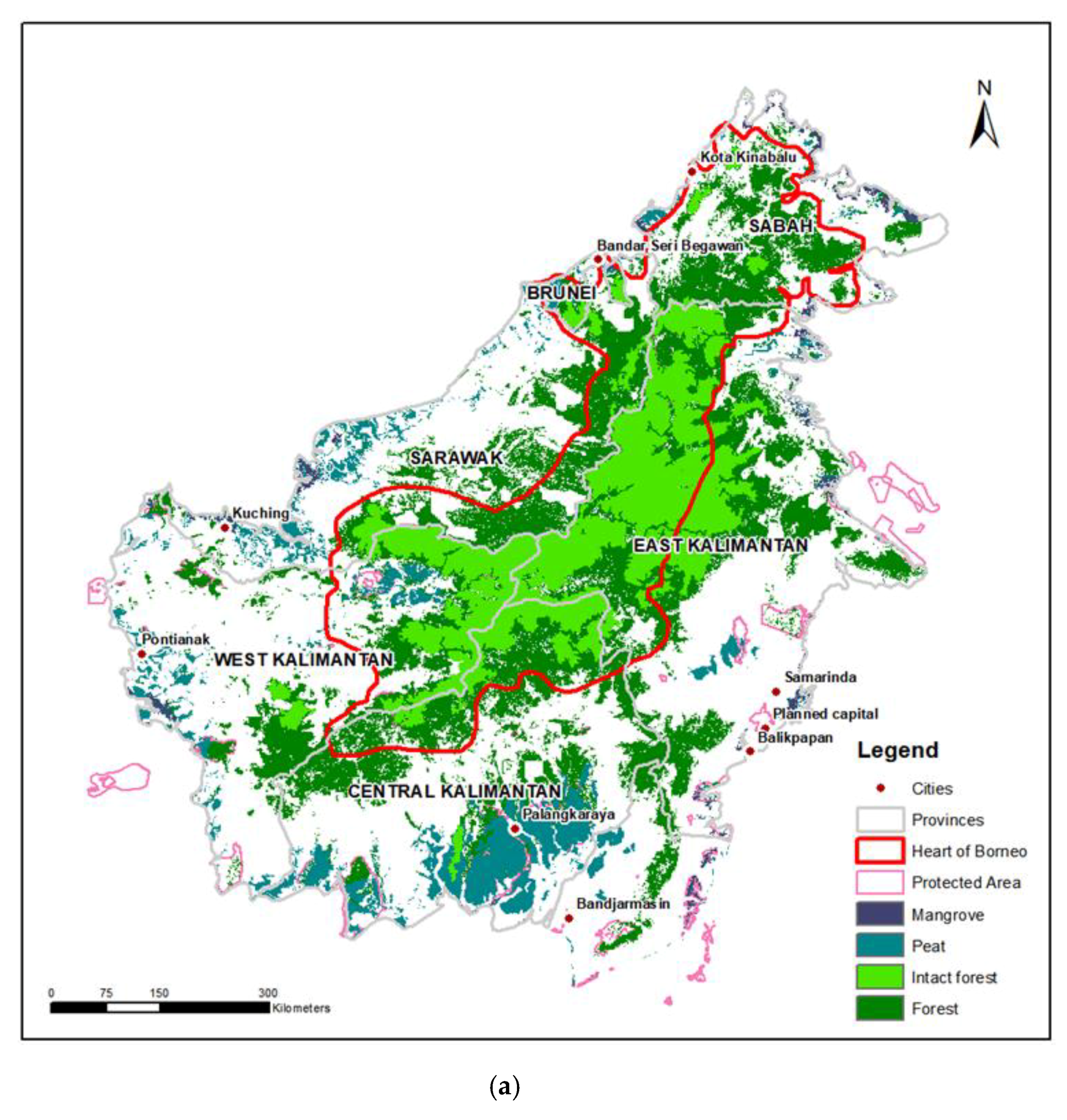
4.3. Best Practices for Protecting Borneo

Even without the new capital, Indonesia already faces enormous environmental challenges and threats to biodiversity. Indonesia loses around 10,000 km2 of forest annually, and forest cover is expected to fall from 50% in 2017 to 38% by 2045, according to the National Medium-Term Development Plan 2020–2024 [92]. Kalimantan has lost sensitive ecosystems such as peatland, which shrank from 54% of its original extent in 2000 to 40% in 2015. Also, Kalimantan hosts sensitive habitat, important for many endangered species. For example, forest across four of Indonesia’s large islands (Sumatra, Java, Kalimantan and Sulawesi) will be reduced from 80% in 2017 to 50% by 2045, and this is projected to reduce Bornean orang-utan populations by 38% (note that these forest cover estimates are Indonesia’s official statistics as presented in [92]). Without timely and effective action, the new capital may only serve to aggravate the loss of forest and habitat.
As such, a key goal for the new national capital must be to ensure the protection of Borneo’s ecosystems in order to preserve its natural capital, ecosystem services, and sociocultural values for future generations [93]. Implementing current best practices in impact assessment and sustainability should be the starting point. The commonly advocated Environmental and Social Impact Assessments, as well as Strategic Environmental Assessments, should be implemented seriously and transparently with proper accountability to local and international stakeholders [94,95]. The mitigation hierarchy should be applied to ensure no negative impact on the environment and to aspire towards overall net gain, with requirements to (1) avoid, (2) minimise, (3) remediate, and (4) offset biodiversity loss [96]. Other examples of ecological offsets and compensation, including in developing countries, should be studied and adapted for local implementation [97,98]. Evidence already suggests that protected area (PA) networks in Borneo are inadequate [99]; PAs should be urgently extended, enforced and made irrevocable before further encroachment by development. Fair, prior, and informed consent (FPIC) [100] should be mandatory for all projects to ensure that stakeholders such as local peoples are adequately consulted and are supportive. These best practices should be enforced not just to the Bukit Soeharto Grand Forest Park situated within 10 km of the site, but also across Borneo, as the impacts of the construction of the planned capital will be far reaching.
Whether these best practices can go beyond aspiration and be successfully implemented will hinge on the institutional capacity of the Indonesian government and the availability of funds either from domestic or and/or foreign investment. Throughout the developing world, weak governance and corruption have been repeatedly implicated in failures to protect environments and livelihoods in development projects [43]. Unfortunately, Indonesia’s recurring failures to resolve illegal slash-and-burn and the regular Southeast Asian haze issue despite decades of political pressure from ASEAN neighbours do not inspire much confidence in Indonesia’s governance capabilities [101,102]. The onus lies on the Indonesian government to implement these best practices among its agencies and to impose enforceable requirements on the private sector. Persistent attention from the scientific and international community [103], as well as capacity-building efforts, can also be effective in improving accountability and environmental outcomes, as exemplified by issues such as oil palm [104], China’s Belt and Road projects [44,105], and the REDD+ framework for deforestation [106]. Moreover, the natural ecosystems of Borneo represent a shared heritage common to humanity, similar to other well-known ecosystems such as the Amazon and Great Barrier Reef [107], and should therefore be of international interest.

5. Conclusions

Our analysis of previous planned capitals suggests that, while a wide range of expansion trajectories are possible, size and rate of expansion are determined by how large the country is and whether construction and relocation can be successfully executed. As such, we consider the Indonesian government’s plans for the new capital to occupy 2000 km2 by 2045 (i.e., a 30 km radius) to be plausible. The direct footprint of the capital is likely to affect Bukit Soeharto Grand Forest Park within 10 km, and indirect impacts could affect many more sensitive ecosystems such as mangrove and peat. Deforestation emissions from the new capital’s direct (30 km) and indirect (200 km) footprint could be approximately 50 MtCO2e and 2326 MtCO2e, respectively, equivalent to 2.7–126% of Indonesia’s 2014 greenhouse gas emissions. Fortunately, the new capital is sited on a coastal site more than 200 km away from the Heart of Borneo ecoregion, which will spare Borneo the brunt of the immediate direct impacts. However, indirect spatial impacts can be very large, and along with environmental justice issues arising from further marginalisation of disadvantaged groups, present a significant downside to the new capital’s development that must be preempted. To prevent this, international best practices must be applied not just to the new capital’s site but across Borneo. International best practices should also be integrated to the social and geographical conditions in Indonesia while ensuring that the local people are included in the decision-making process. Furthermore, Environmental and Social Impact Assessments, and Strategic Environmental Assessments, should be implemented seriously and transparently with proper accountability to local and international stakeholders. The possibilities afforded by the new capital to restructure socio-political processes should also be seized as the catalyst to start doing things right, socially and environmentally. Our paper has highlighted the broad range of some potential impacts from Indonesia’s new capital; further research will find this a useful starting point in analysing impacts in specific domains, such as biodiversity, carbon emissions, hydrology, urban planning, land-use change modelling, socio-politics, and management strategies.

Author Contributions

Conceptualization, H.C.T., A.M.L. and A.C.-A.; formal analysis, H.C.T. and A.M.L.; writing—original draft preparation, H.C.T.; writing—review and editing, H.C.T., A.M.L., S.S. and A.C.-A.; supervision, A.C.-A. and A.M.L. All authors have read and agreed to the published version of the manuscript.

Funding

This research received no external funding.

Conflicts of Interest

The authors declare no conflict of interest.

References

  1. Steinberg, F. Jakarta: Environmental Problems and Sustainability. Habitat Int. 2007, 31, 354–365. [Google Scholar] [CrossRef]
  2. Firman, T.; Surbakti, I.M.; Idroes, I.C.; Simarmata, H.A. Potential Climate-Change Related Vulnerabilities in Jakarta: Challenges and Current Status. Habitat Int. 2011, 35, 372–378. [Google Scholar] [CrossRef]
  3. Yusuf, A.A.; Francisco, H. Climate Change Vulnerability Mapping for Southeast Asia. IDRC Research Results; Singapore. 2009. Available online: https://idl-bnc-idrc.dspacedirect.org/handle/10625/46380 (accessed on 11 September 2020).
  4. Maulia, E. Jokowi Announces Indonesia’s New Capital in East Kalimantan. Nikkei Asia Review. 26 August 2019. Jakarta. Available online: https://asia.nikkei.com/Politics/Jokowi-announces-Indonesia-s-new-capital-in-East-Kalimantan (accessed on 11 September 2020).
  5. Nugroho, J. What’s behind Jokowi’s Plan to Move Indonesia’s Capital out of Jakarta? Today Online. 19 June 2019. Singapore. Available online: https://www.todayonline.com/commentary/whats-behind-president-jokowis-plan-move-indonesian-capital-out-jakarta (accessed on 11 September 2020).
  6. Logan, D. Myanmar’s Phantom Capital. The Globalist. 28 September 2013, p. 9. Available online: https://www.theglobalist.com/myanmars-phantom-capital/ (accessed on 11 September 2020).
  7. Widianto, S. Indonesia Floats Yet Another Plan to Move Its Sinking Capital. Foreign Policy. 10 May 2019. Available online: https://foreignpolicy.com/2019/05/10/indonesia-floats-yet-another-plan-to-move-its-sinking-capital/ (accessed on 11 September 2020).
  8. Cornock, O. (Ed.) Emerging Cities: Overview. In The Report: Indonesia 2018; Oxford Business Group: London, UK, 2018; p. 90. [Google Scholar]
  9. Ningsih, W.W.; Nur, V. Tiru Malaysia, SBY Dukung Pemindahan Ibukota (Imitate Malaysia, SBY supports the Capital Relocation). Inilah. 3 September 2010. Jakarta. Available online: https://nasional.inilah.com/read/detail/798451/tiru-malaysia-sby-dukung-pemindahan-ibukota (accessed on 11 September 2020).
  10. Reuters. Indonesia Picks McKinsey to Help Plan Capital in the Forest. Channel News Asia. 15 October 2019. Jakarta. Available online: https://www.channelnewsasia.com/news/business/indonesia-picks-mckinsey-to-help-plan-capital-in-the-forest-12002506 (accessed on 11 September 2020).
  11. Siregar, K. New Indonesia Capital: Land Prices Set to Soar but Not All Locals Thrilled. Channel News Asia. 18 September 2019. Sepaku, East Kalimantan. Available online: https://www.channelnewsasia.com/news/asia/indonesia-new-capital-east-kalimantan-land-prices-soar-11912242 (accessed on 11 September 2020).
  12. Poon, L. Indonesia’s Capital Move Worries Environmentalists. CityLab. 26 August 2019. Available online: https://www.citylab.com/environment/2019/08/indonesia-new-capital-borneo-jakarta-sinking-environment/596824/ (accessed on 11 September 2020).
  13. Anugrah, I. Out of Sight, out of Mind? Political Accountability and Indonesia’s New Capital Plan. New Mandala. 23 July 2019. Available online: https://www.newmandala.org/out-of-sight-out-of-mind-political-accountability-and-indonesias-new-capital-plan/ (accessed on 11 September 2020).
  14. Adri, N. Wanted: Designs for Indonesia’s New Smart, Green Capital City. The Jakarta Post. 2019. Balikpapan. Available online: https://www.thejakartapost.com/news/2019/10/03/wanted-designs-for-indonesias-new-smart-green-capital-city.html (accessed on 11 September 2020).
  15. Newman, P. The Environmental Impact of Cities. Environ. Urban. 2006, 18, 275–295. [Google Scholar] [CrossRef]
  16. Hoff, H.; Döll, P.; Fader, M.; Gerten, D.; Hauser, S.; Siebert, S. Water Footprints of Cities – Indicators for Sustainable Consumption and Production. Hydrol. Earth Syst. Sci. 2014, 18, 213–226. [Google Scholar] [CrossRef] [Green Version]
  17. Lin, J.J.; Yang, A.T. Does the Compact-City Paradigm Foster Sustainability? An Empirical Study in Taiwan. Environ. Plan. B Plan. Des. 2006, 33, 365–380. [Google Scholar] [CrossRef]
  18. Ng, E. (Ed.) Designing High-Density Cities; Earthscan: London, UK, 2010. [Google Scholar]
  19. Desfika, T.S. Government to Build New Airport in New Capital. PwC Indonesia. 27 February 2020. Jakarta. Available online: https://www.pwc.com/id/en/media-centre/infrastructure-news/february-2020/government-to-build-new-airport-in-new-capital.html (accessed on 11 September 2020).
  20. Larivière, I.; Lafrance, G. Modelling the Electricity Consumption of Cities: Effect of Urban Density. Energy Econ. 1999, 21, 53–66. [Google Scholar] [CrossRef]
  21. Deilmann, C.; Lehmann, I.; Reißmann, D.; Hennersdorf, J. Data envelopment analysis of cities—Investigation of the ecological and economic efficiency of cities using a benchmarking concept from production management. Ecol. Indic. 2016, 67, 798–806. [Google Scholar] [CrossRef]
  22. Wackernagel, M.; Kitzes, J.; Moran, D.; Goldfinger, S.; Thomas, M. The Ecological Footprint of cities and regions: Comparing resource availability with resource demand. Environ. Urban. 2006, 18, 103–112. [Google Scholar] [CrossRef]
  23. Folke, C.; Jansson, Å.; Larsson, J.; Costanza, R. Ecosystem Appropriation by Cities. Ambio 1997, 26, 167–172. [Google Scholar]
  24. Rees, W.E.; Wackernagel, M. Urban Ecological Footprints: Why Cities Cannot be Sustainable—and Why They are a Key to Sustainability. In Urban Ecology; Springer: Boston, MA, USA, 2008; pp. 537–555. [Google Scholar]
  25. Van Vliet, J. Direct and indirect loss of natural area from urban expansion. Nat. Sustain. 2019, 2, 755–763. [Google Scholar] [CrossRef]
  26. Derudder, B.; Taylor, P.J. Central flow theory: Comparative connectivities in the world-city network. Reg. Stud. 2017, 52, 1029–1040. [Google Scholar] [CrossRef]
  27. Taylor, P.J.; Hoyler, M.; Verbruggen, R. External Urban Relational Process: Introducing Central Flow Theory to Complement Central Place Theory. Urban Stud. 2010, 47, 2803–2818. [Google Scholar] [CrossRef] [Green Version]
  28. Wu, K.; Fang, C.; Zhao, M. The Spatial Organization and Structure Complexity of Chinese Intercity Networks. Geogr. Res. 2015, 34, 711–728. [Google Scholar]
  29. Billen, G.; Barles, S.; Garnier, J.; Rouillard, J.; Benoit, P. The food-print of Paris: Long-term reconstruction of the nitrogen flows imported into the city from its rural hinterland. Reg. Environ. Chang. 2008, 9, 13–24. [Google Scholar] [CrossRef]
  30. Van Klinken, G. Blood, timber, and the state in West Kalimantan, Indonesia. Asia Pac. Viewp. 2008, 49, 35–47. [Google Scholar] [CrossRef]
  31. Cassidy, E.; Hamzah, H. 5 Maps Show How Moving Indonesia’s Capital Could Impact the Environment—Resource Watch. Available online: https://blog.resourcewatch.org/2019/10/01/5-maps-show-how-moving-indonesias-capital-could-impact-the-environment/ (accessed on 16 October 2019).
  32. Tan, Y. Will Indonesia’s New Capital Just Move the Problem to the Jungle? BBC. 3 September 2019. Available online: https://www.bbc.com/news/world-asia-49481090 (accessed on 11 September 2020).
  33. Struebig, M.J.; Wilting, A.; Gaveau, D.L.; Meijaard, E.; Smith, R.J.; Abdullah, T.; Belant, J.L. Targeted Conservation to Safeguard a Biodiversity Hotspot from Climate and Land-Cover Change. Curr. Biol. 2015, 25, 372–378. [Google Scholar] [CrossRef] [Green Version]
  34. Fardah, D.P. Environmental Study of New Capital by November. Antara News. 28 August 2019. Jakarta. Available online: https://en.antaranews.com/news/131776/environmental-study-of-new-capital-by-november (accessed on 11 September 2020).
  35. Zhang, Q.; Seto, K.C. Can Night-Time Light Data Identify Typologies of Urbanization? A Global Assessment of Successes and Failures. Remote Sens. 2013, 5, 3476–3494. [Google Scholar] [CrossRef] [Green Version]
  36. Seto, K.C.; Güneralp, B.; Hutyra, L.R. Global forecasts of urban expansion to 2030 and direct impacts on biodiversity and carbon pools. Proc. Natl. Acad. Sci. USA 2012, 109, 16083–16088. [Google Scholar] [CrossRef] [Green Version]
  37. Levin, N.; Kyba, C.C.; Zhang, Q.; De Miguel, A.S.; Román, M.O.; Li, X.; Portnov, B.A.; Molthan, A.L.; Jechow, A.; Miller, S.D.; et al. Remote sensing of night lights: A review and an outlook for the future. Remote Sens. Environ. 2020, 237, 111443. [Google Scholar] [CrossRef]
  38. Shi, K.; Huang, C.; Chen, Y.; Li, L. Remotely sensed nighttime lights reveal increasing human activities in protected areas of China mainland. Remote Sens. Lett. 2018, 9, 467–476. [Google Scholar] [CrossRef]
  39. Xue, X.; Lin, Y.; Zheng, Q.; Wang, K.; Zhang, J.; Deng, J.; Abubakar, G.A.; Gan, M. Mapping the fine-scale spatial pattern of artificial light pollution at night in urban environments from the perspective of bird habitats. Sci. Total. Environ. 2020, 702, 134725. [Google Scholar] [CrossRef]
  40. Zheng, Q.; Zeng, Y.; Deng, J.; Wang, K.; Jiang, R.; Ye, Z. “Ghost cities” identification using multi-source remote sensing datasets: A case study in Yangtze River Delta. Appl. Geogr. 2017, 80, 112–121. [Google Scholar] [CrossRef]
  41. Yilmaz, K. Comparison of Quantitative and Qualitative Research Traditions: Epistemological, theoretical, and methodological differences. Eur. J. Educ. 2013, 48, 311–325. [Google Scholar] [CrossRef]
  42. Lechner, A.M.; Tan, C.M.; Tritto, A.; Horstmann, A.; Teo, H.C.; Owen, J.R.; Campos-Arceiz, A. The Belt and Road Initiative: Environmental Impacts in Southeast Asia. Trends Southeast Asia 2019, 18. [Google Scholar] [CrossRef]
  43. Tan-Mullins, M.; Urban, F.; Mang, G. Evaluating the Behaviour of Chinese Stakeholders Engaged in Large Hydropower Projects in Asia and Africa. China Q. 2017, 230, 464–488. [Google Scholar] [CrossRef] [Green Version]
  44. Teo, H.C.; Lechner, A.M.; Walton, G.W.; Chan, F.; Cheshmehzangi, A.; Tan-Mullins, M.; Chan, H.K.; Sternberg, T.; Campos-Arceiz, A. Environmental Impacts of Infrastructure Development under the Belt and Road Initiative. Environments 2019, 6, 72. [Google Scholar] [CrossRef] [Green Version]
  45. Elvidge, C.D.; E Baugh, K.; Dietz, J.B.; Bland, T.; Sutton, P.C.; Kroehl, H.W. Radiance Calibration of DMSP-OLS Low-Light Imaging Data of Human Settlements. Remote Sens. Environ. 1999, 68, 77–88. [Google Scholar] [CrossRef]
  46. Ma, L.; Wu, J.; Li, W.; Peng, J.; Liu, H. Evaluating Saturation Correction Methods for DMSP/OLS Nighttime Light Data: A Case Study from China’s Cities. Remote Sens. 2014, 6, 9853–9872. [Google Scholar] [CrossRef] [Green Version]
  47. Li, X.; Li, D.; Xu, H.; Wu, C. Intercalibration between DMSP/OLS and VIIRS night-time light images to evaluate city light dynamics of Syria’s major human settlement during Syrian Civil War. Int. J. Remote Sens. 2017, 38, 5934–5951. [Google Scholar] [CrossRef]
  48. Wu, J.; He, S.; Peng, J.; Li, W.; Zhong, X. Intercalibration of DMSP-OLS night-time light data by the invariant region method. Int. J. Remote Sens. 2013, 34, 7356–7368. [Google Scholar] [CrossRef]
  49. Miettinen, J.; Shi, C.; Liew, S.C. 2015 Land cover map of Southeast Asia at 250 m spatial resolution. Remote Sens. Lett. 2016, 7, 701–710. [Google Scholar] [CrossRef]
  50. WRI. Global Forest Watch. Available online: http://www.globalforestwatch.org/ (accessed on 2 November 2019).
  51. Baccini, A.; Walker, W.; Carvalho, L.; Farina, M.; Sulla-Menashe, D.; Houghton, R.A. Tropical Forests are a Net Carbon Source Based on New Measurements of Gain and Loss. Science 2017, 358, 230–234. [Google Scholar] [CrossRef] [Green Version]
  52. Tong, X.; Brandt, M.; Yue, Y.; Ciais, P.; Jepsen, M.R.; Penuelas, J.; Rasmussen, K. Forest management in southern China generates short term extensive carbon sequestration. Nat. Commun. 2020, 11, 129. [Google Scholar] [CrossRef]
  53. Population Stat. Population Stat - World Statistical Data. Available online: https://populationstat.com (accessed on 11 September 2020).
  54. World Bank. World Bank National Accounts Data—GDP Per Capita (Current US$). Available online: https://data.worldbank.org/indicator/NY.GDP.PCAP.CD (accessed on 11 September 2020).
  55. Ju, Y.; Dronova, I.; Guo, Q.; Zhang, X. Analysis of urbanization dynamics in mainland China using pixel-based night-time light trajectories from 1992 to 2013. Int. J. Remote Sens. 2017, 38, 6047–6072. [Google Scholar] [CrossRef]
  56. Bruederle, A.; Hodler, R. Nighttime lights as a proxy for human development at the local level. PLoS ONE 2018, 13, e0202231. [Google Scholar] [CrossRef] [Green Version]
  57. Zheng, Q.; Weng, Q.; Huang, L.; Wang, K.; Deng, J.; Jiang, R.; Gan, M. A new source of multi-spectral high spatial resolution night-time light imagery—JL1-3B. Remote Sens. Environ. 2018, 215, 300–312. [Google Scholar] [CrossRef]
  58. Gokkon, B. Red Flags as Indonesia Eyes Relocating Its Capital City to Borneo. Mongabay. 2 August 2019. Jakarta. Available online: https://news.mongabay.com/2019/08/red-flags-as-indonesia-eyes-relocating-its-capital-city-to-borneo/ (accessed on 11 September 2020).
  59. Beeckmans, L. The Architecture of Nation-building in Africa as a Development Aid Project: Designing the capital cities of Kinshasa (Congo) and Dodoma (Tanzania) in the post-independence years. Prog. Plan. 2018, 122, 1–28. [Google Scholar] [CrossRef]
  60. Abubakar, I.R.; Doan, P.L. Building new capital cities in Africa: Lessons for new satellite towns in developing countries. Afr. Stud. 2017, 76, 546–565. [Google Scholar] [CrossRef]
  61. Preecharushh, D. Myanmar’s New Capital City of Naypyidaw. In Engineering Earth; Springer: Dordrecht, The Netherlands, 2010; pp. 1021–1044. [Google Scholar]
  62. Steger, I.; Lee, S. A New Capital Built from Scratch Is an Unlikely Utopia for Korean Families. Quartz. 2018. Sejong. Available online: https://qz.com/1275754/a-new-capital-built-from-scratch-is-an-unlikely-utopia-for-korean-families/ (accessed on 11 September 2020).
  63. Tacconi, L.; Muttaqin, M.Z. Reducing emissions from land use change in Indonesia: An overview. For. Policy Econ. 2019, 108, 101979. [Google Scholar] [CrossRef]
  64. Grossman, G.; Krueger, A. Environmental Impacts of a North American Free Trade Agreement; National Bureau of Econonomic Research: Cambridge, MA, USA, 1991; Available online: http://www.nber.org/papers/w3914.pdf (accessed on 11 September 2020).
  65. Zeng, Y.; Maxwell, S.; Runting, R.K.; Venter, O.; Watson, J.E.M.; Carrasco, L.R. Environmental destruction not avoided with the Sustainable Development Goals. Nat. Sustain. 2020, 1–4. [Google Scholar] [CrossRef]
  66. Lefebvre, H. The Production of Space; Donaldson-Smith, N., Ed.; Basil Blackwell: Oxford, UK, 1991. [Google Scholar]
  67. Soja, E.W. Taking Space Personally. In The Spatial Turn: Interdisciplinary perspectives; Warf, B., Arias, S., Eds.; Routledge: Oxford, UK, 2009; pp. 11–35. [Google Scholar]
  68. Herbst, J. States and Power in Africa: Comparative Lessons in Authority and Control; Princeton University Press: Princeton, NJ, USA, 2000. [Google Scholar]
  69. Gottmann, J. The Role of Capital Cities. Ekistics 1977, 44, 240–243. [Google Scholar]
  70. Schatz, E. What Capital Cities Say About State and Nation Building. Natl. Ethn. Politics 2004, 9, 111–140. [Google Scholar] [CrossRef]
  71. James, P.E.; Faissol, S. The Problem of Brazil’s Capital City. Geogr. Rev. 1956, 46, 301. [Google Scholar] [CrossRef]
  72. Laurance, W.F.; Goosem, M.; Laurance, S.G. Impacts of roads and linear clearings on tropical forests. Trends Ecol. Evol. 2009, 24, 659–669. [Google Scholar] [CrossRef] [PubMed]
  73. Fearnside, P.M. Deforestation in Brazilian Amazonia: History, Rates, and Consequences. Conserv. Biol. 2005, 19, 680–688. [Google Scholar] [CrossRef]
  74. Povera, A. Sarawak Sees Positive Elements in Indonesia’s Plan to Relocate Capital to Kalimantan. New Straits Times. 13 August 2019. Kuching. Available online: https://www.nst.com.my/news/nation/2019/08/512506/sarawak-sees-positive-elements-indonesias-plan-relocate-capital (accessed on 11 September 2020).
  75. Tawie, S. Sarawak Deputy CM: Urgent Need for Security Road Network along Sarawak-Kalimantan Border. Malay Mail. 25 October 2019. Kuching. Available online: https://www.malaymail.com/news/malaysia/2019/10/25/sarawak-deputy-cm-urgent-need-for-security-road-network-along-sarawak-kalim/1803757 (accessed on 11 September 2020).
  76. Alamgir, M.; Campbell, M.J.; Sloan, S.; Suhardiman, A.; Supriatna, J.; Laurance, W.F. High-risk infrastructure projects pose imminent threats to forests in Indonesian Borneo. Sci. Rep. 2019, 9, 140. [Google Scholar] [CrossRef]
  77. Winarso, H. Urban Dualism in the Jakarta Metropolitan Area; Springer: Tokyo, Japan, 2011; pp. 163–191. [Google Scholar]
  78. Potts, D. Capital Relocation in Africa: The Case of Lilongwe in Malawi. Geogr. J. 1985, 151, 182. [Google Scholar] [CrossRef]
  79. Moser, S. New Cities: Old Wine in New Bottles? Dialogues Hum. Geogr. 2015, 5, 31–35. [Google Scholar] [CrossRef]
  80. Siregar, K. New Indonesia Capital: Indigenous Tribes Fear Further Marginalisation. Channel News Asia. 20 September 2019. Penajam Paser Utara, East Kalimantan. Available online: https://www.channelnewsasia.com/news/asia/indonesia-new-capital-east-kalimantan-indigenous-tribes-11920292 (accessed on 11 September 2020).
  81. Pow, C.-P. Public intervention, private aspiration: Gated communities and the condominisation of housing landscapes in Singapore. Asia Pac. Viewp. 2009, 50, 215–227. [Google Scholar] [CrossRef]
  82. Harvey, D. Rebel Cities: From the Right to the City to the Urban Revolution; Verso: London, UK, 2012. [Google Scholar]
  83. Padawangi, R. Reform, resistance and empowerment: Constructing the public city from the grassroots in Jakarta, Indonesia. Int. Dev. Plan. Rev. 2014, 36, 33–50. [Google Scholar] [CrossRef]
  84. Maitland, R. Capitalness is contingent: Tourism and national capitals in a globalised world. Curr. Issues Tour. 2012, 15, 3–17. [Google Scholar] [CrossRef]
  85. Bekus, N.; Medeuova, K. Re-Interpreting National Ideology in the Contemporary Urban Space of Astana. Urbanities 2017, 7, 10–21. [Google Scholar]
  86. Rapaport, A. On the Nature of Capitals and Their Physical Expression. In Capital cities: International perspectives; Taylor, J., Lengelle, J.G., Andrew, C., Eds.; Carleton University Press: Ottawa, ON, Canada, 1993; p. 36. [Google Scholar]
  87. Kusno, A. Behind the Postcolonial: Architecture, Urban Space and Political Cultures in Indonesia; Routledge: London, UK, 2000. [Google Scholar]
  88. Kusno, A. Whither Nationalist Urbanism? Public Life in Governor Sutiyoso’s Jakarta. Urban Stud. 2004, 41, 2377–2394. [Google Scholar] [CrossRef]
  89. Lee, T. Defect or Defend: Military Responses to Popular Protests in Authoritarian Asia; John Hopkins University Press: Baltimore, MD, USA, 2015. [Google Scholar]
  90. Castells, M. The Rise of the Network Society; Wiley: Hoboken, NJ, USA, 2009. [Google Scholar]
  91. Soja, E.W. BeyondPostmetropolis. Urban Geogr. 2011, 32, 451–469. [Google Scholar] [CrossRef]
  92. Bappenas. Rencana Pembangunan Jangka Menengah Nasional (National Mid Term Development Plan) 2020–2024. Jakarta. 2019. Available online: https://www.bappenas.go.id/files/rpjmn/Narasi%20RPJMN%20IV%202020-2024_Revisi%2014%20Agustus%202019.pdf (accessed on 11 September 2020).
  93. Abram, N.K.; Meijaard, E.; Ancrenaz, M.; Runting, R.K.; Wells, J.A.; A Gaveau, D.L.; Pellier, A.-S.; Mengersen, K. Spatially explicit perceptions of ecosystem services and land cover change in forested regions of Borneo. Ecosyst. Serv. 2014, 7, 116–127. [Google Scholar] [CrossRef] [Green Version]
  94. White, L.; Noble, B.F. Strategic environmental assessment for sustainability: A review of a decade of academic research. Environ. Impact Assess. Rev. 2013, 42, 60–66. [Google Scholar] [CrossRef]
  95. Narain, D.; Maron, M.; Teo, H.C.; Hussey, K.; Lechner, A.M. Best-practice biodiversity safeguards for Belt and Road Initiative’s financiers. Nat. Sustain. 2020, 3, 650–657. [Google Scholar] [CrossRef]
  96. Kiesecker, J.; Copeland, H.; Pocewicz, A.; McKenney, B. Development by design: Blending landscape-level planning with the mitigation hierarchy. Front. Ecol. Environ. 2010, 8, 261–266. [Google Scholar] [CrossRef]
  97. Maron, M.; Gordon, A.; Mackey, B.; Possingham, H.P.; Watson, J.E.M. Conservation: Stop Misuse of Biodiversity Offsets. Nature 2015, 523, 401–403. [Google Scholar] [CrossRef] [Green Version]
  98. Wang, X.; Berman, E.M.; Chen, D.-Y.; Niu, X. Strategies to Improve Environmental Networks for Pollution Control: Evidence from Eco-Compensation Programs in China. J. Environ. Manage. 2019, 234, 387–395. [Google Scholar] [CrossRef]
  99. Scriven, S.A.; Hodgson, J.A.; McClean, C.J.; Hill, J.K. Protected Areas in Borneo May Fail to Conserve Tropical Forest Biodiversity under Climate Change. Biol. Conserv. 2015, 184, 414–423. [Google Scholar] [CrossRef] [Green Version]
  100. Esteves, A.M.; Franks, D.; Vanclay, F. Social Impact Assessment: The State of the Art. Impact Assess. Proj. Apprais. 2012, 30, 34–42. [Google Scholar] [CrossRef]
  101. Brauer, M.; Hisham-Hashim, J. Fires in Indonesia: Crisis and Reaction. Environ. Sci. Technol. 1998, 32, 404A–407A. [Google Scholar] [CrossRef]
  102. Forsyth, T. Public Concerns about Transboundary Haze: A Comparison of Indonesia, Singapore, and Malaysia. Glob. Environ. Chang. 2014, 25, 76–86. [Google Scholar] [CrossRef] [Green Version]
  103. Teo, H.C.; Campos-Arceiz, A.; Li, B.V.; Wu, M.; Lechner, A.M. Building a green Belt and Road: A systematic review and comparative assessment of the Chinese and English-language literature. PLoS ONE 2020, 15, e0239009. [Google Scholar] [CrossRef]
  104. Laurance, W.F.; Koh, L.P.; Butler, R.; Sodhi, N.S.; Bradshaw, C.J.A.; Neidel, J.D.; Consunji, H.; Vega, J.M. Improving the Performance of the Roundtable on Sustainable Palm Oil for Nature Conservation. Conserv. Biol. 2010, 24, 377–381. [Google Scholar] [CrossRef] [PubMed]
  105. Lechner, A.M.; Chan, F.K.S.; Campos-Arceiz, A. Biodiversity Conservation Should Be a Core Value of China’s Belt and Road Initiative. Nat. Ecol. Evol. 2018, 2, 408–409. [Google Scholar] [CrossRef]
  106. Thompson, M.C.; Baruah, M.; Carr, E.R. Seeing REDD+ as a Project of Environmental Governance. Environ. Sci. Policy 2011, 14, 100–110. [Google Scholar] [CrossRef]
  107. Chernela, J.; Zanotti, L. Limits to Knowledge: Indigenous Peoples, NGOs, and the Moral Economy in the Eastern Amazon of Brazil. Conserv. Soc. 2014, 12, 306–317. [Google Scholar] [CrossRef]
Figure 1. Map of Indonesia indicating major islands, and location of the current capital Jakarta in Java and new planned capital in Borneo.
Land 09 00438 g001
Figure 2. Pre- and post-calibrated (a,b) Defense Meteorological Satellite Program-Operational Linescan System total light index (DMSP-OL TLI) for study area.
Land 09 00438 g002
Figure 3. Mean stable night lights Day/Night (DN) within 5, 10, 25 and 50 km buffers(ad) from 1992 to 2018. Fully saturated DN value is 63. Data for Naypyidaw and Sejong only, shown from year of construction (2002 and 2007, respectively).
Land 09 00438 g003aLand 09 00438 g003b
Figure 4. (a) Borneo forest cover map and (b) approximate location of Indonesia’s new planned capital, with land cover and 30, 50 and 200 km buffers around the planned capital.
Land 09 00438 g004aLand 09 00438 g004b
Table 1. List of planned capitals.
Capital CityCountryYear % Country Population in Capital % Annual Night-Lights Change 4
NamePopulation (Millions, 2019) 1NamePopulation (Millions, 2019)GDP Per Capita (2019) 2ConstructionOfficiated 3
Abuja3.1Nigeria20322301970s19911.6%2.7%
Belmopan0.02Belize0.394815196719704.2%11%
Brasília4.6Brazil2138717195719602.2%0.19%
Canberra0.45Australia2554,907191319271.8%0.48%
Dodoma0.42Tanzania611122197420060.7%6.2%
Islamabad1.1Pakistan20612851960s19660.5%1.2%
Lilongwe1.1Malawi20412197019755.5%3.6%
Naypyidaw0.56Myanmar541408200220061.0%30%
Nur-Sultan (Astana)1.1Kazakhstan189731199819976.1%2.7%
Sejong0.33South Korea5231,762200720130.6%5.5%
Washington, D.C.5.3United States33165,281179218001.6%0%
Yamouss-oukro0.36Cote d’Ivoire262286197719831.4%4.6%
1 Population in urban area [53]; 2 Current US$ [54]; 3 Either when officially proclaimed, or when important government functions move; 4 Average change in annual nightlights within 10 km (1992–2018).
Table 2. Vegetation cover within 10, 30, 50 and 200 km buffers of Indonesia’s planned capital and total aboveground carbon biomass stock.
Vegetation Type10 km30 km50 km200 km
Area (km2)Mangrove0362801090
Peat0802002090
Intact forest0000
Forest004513,050
Other vegetation (e.g., mosaic, crops)2901450252024,390
Timber3.929011809810
Oil palm1840079012,510
Total3102260501062,940
Aboveground biomass (Tg C)2.213.523.4634
Potential carbon emissions (MtCO2e)8.050862326
Table 3. Protected areas within 10, 30, 50 and 200 km buffers.
Protected Area10 km30 km50 km200 km
Area (km2)Bukit Soeharto Grand Forest Park17047011
Teluk Apar Nature Reserve 360
Kutai National Park 1910
Lati Petangis Grand Forest Park 34
Padang Luway Nature Reserve 48
Teluk Pamukan Nature Reserve 140
Teluk Adang Nature Reserve 570
Muara Kaman Sedulang Nature Reserve 650
Cumulative total1706406504360
Publisher’s Note: MDPI stays neutral with regard to jurisdictional claims in published maps and institutional affiliations.

