Forest Area Change in the Shifting Landscape Mosaic of the Continental United States from 2001 to 2016
Abstract
1. Highlights
2. Introduction
3. Materials and Methods
3.1. Synopsis
3.2. Land Cover Data
3.3. Change Process Data
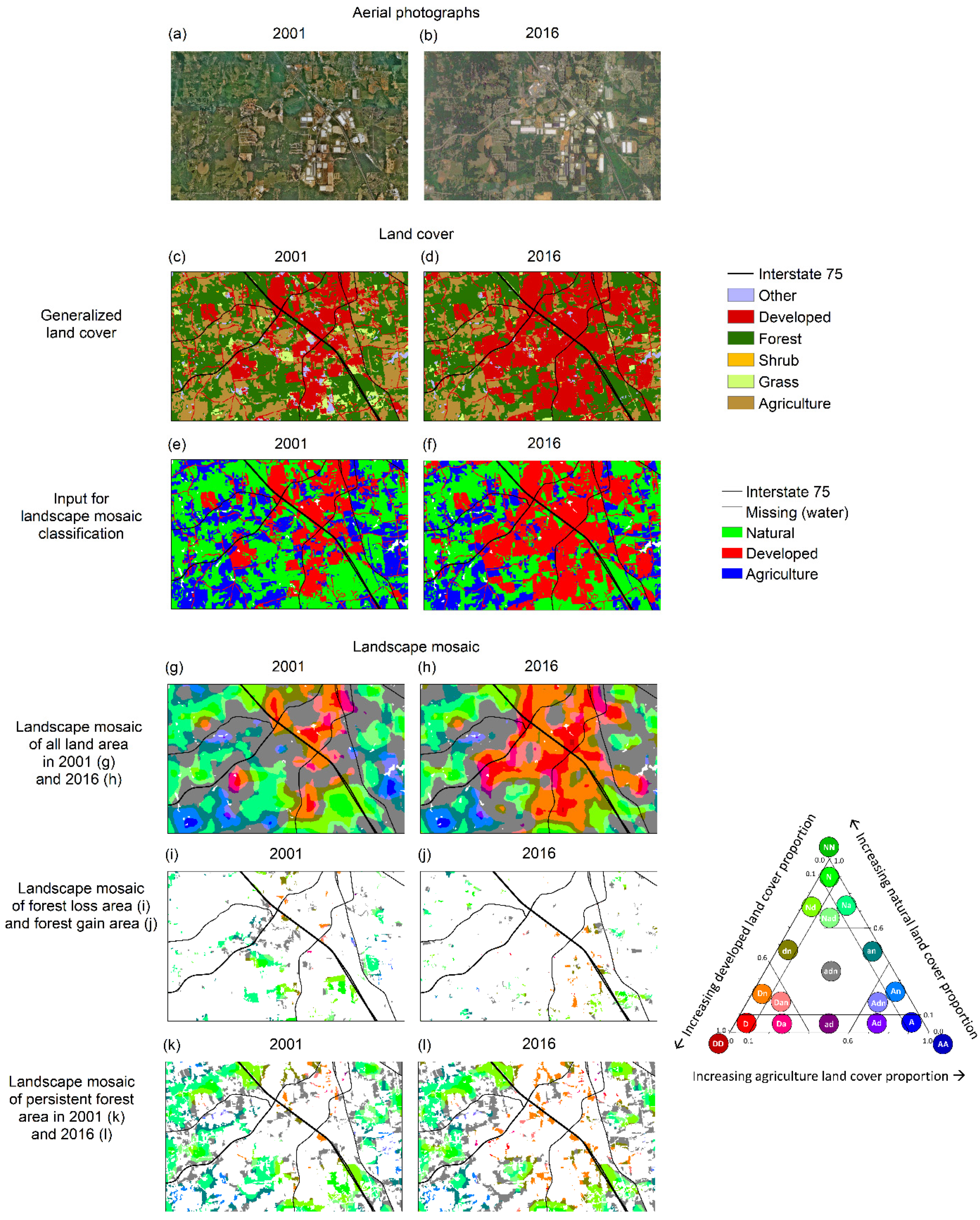
3.4. Landscape Mosaic Classification
4. Analysis
5. Results
5.1. Land Cover Change
5.2. Landscape Mosaic Change
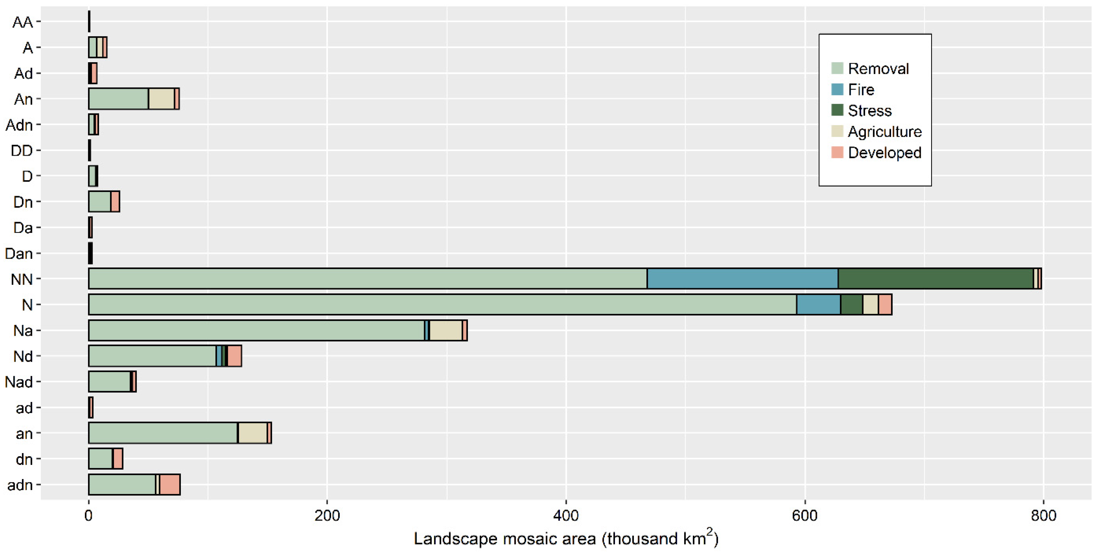
5.3. Change Processes in Landscape Mosaics
5.4. Forest and Landscape Mosaic Change
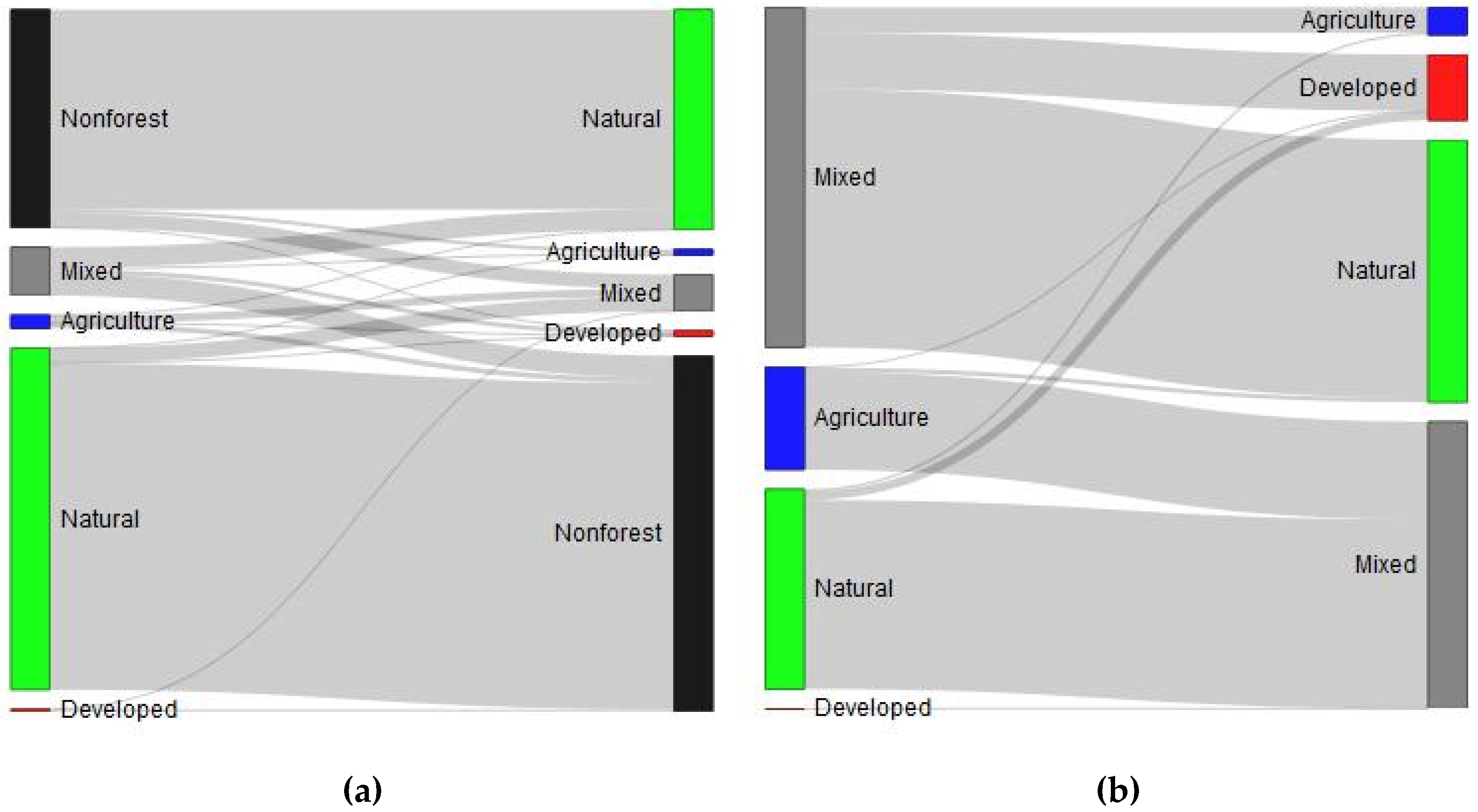
5.4.1. Forest and Landscape Dominance Change
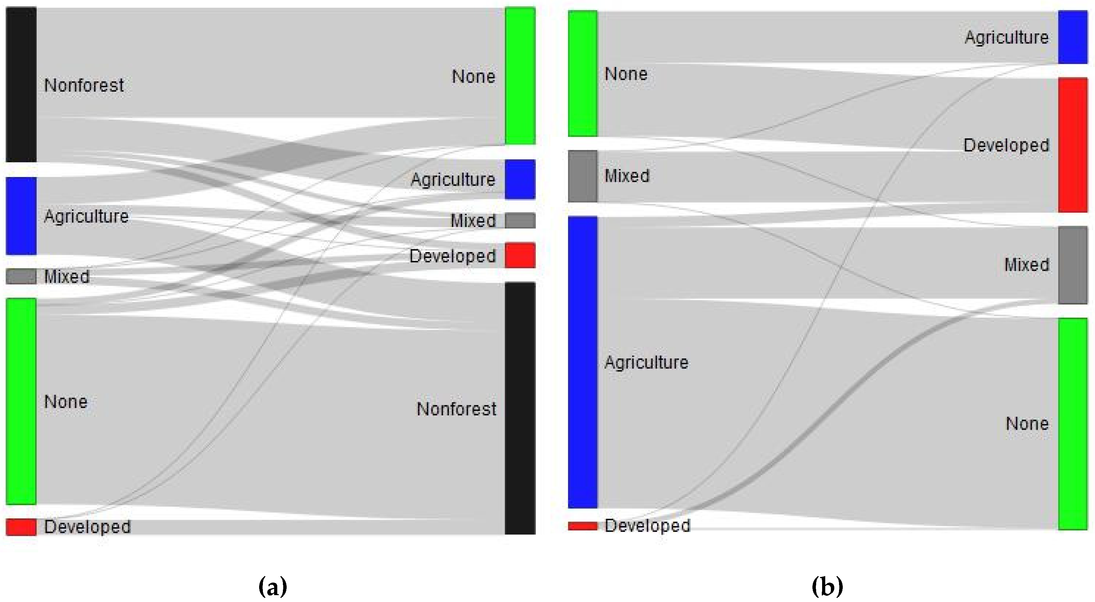
5.4.2. Forest and Landscape Interface Change
6. Discussion
Supplementary Materials
Author Contributions
Funding
Conflicts of Interest
Archived Data
References
- Masek, J.G.; Huang, C.; Wolfe, R.; Cohen, W.; Hall, F.; Kutler, J.; Nelson, P. North American forest disturbance mapped from a decadal Landsat record. Remote. Sens. Environ. 2008, 112, 2914–2926. [Google Scholar] [CrossRef]
- Hansen, M.C.; Stehman, S.V.; Potapov, P.V. Quantification of global gross forest cover loss. Natl. Acad. Sci. USA 2010, 107, 8650–8655. [Google Scholar] [CrossRef] [PubMed]
- Schleeweis, K.G.; Moisen, G.G.; Schroeder, T.A.; Toney, C.; Freeman, E.A.; Goward, S.N.; Huang, C.; Dungan, J.R. US National Maps Attributing Forest Change: 1986–2010. Forestry 2020, 11, 653. [Google Scholar] [CrossRef]
- Sommerfeld, A.; Senf, C.; Buma, B.; D’Amato, A.W.; Després, T.; Díaz-Hormazábal, I.; Fraver, S.; Frelich, L.E.; Gutiérrez, Á.G.; Hart, S.J.; et al. Patterns and drivers of recent disturbances across the temperate forest biome. Nat. Commun. 2018, 9, 4355. [Google Scholar] [CrossRef] [PubMed]
- Cohen, W.B.; Yang, Z.; Stehman, S.V.; Schroeder, T.A.; Bell, D.M.; Masek, J.G.; Huang, C.; Meigs, G.W. Forest disturbance across the conterminous United States from 1985–2012: The emerging dominance of forest decline. For. Ecol. Manag. 2016, 360, 242–252. [Google Scholar] [CrossRef]
- Curtis, P.G.; Slay, C.M.; Harris, N.L.; Tyukavina, A.; Hansen, M.C. Classifying drivers of global forest loss. Science 2018, 361, 1108–1111. [Google Scholar] [CrossRef] [PubMed]
- Homer, C.; Dewitz, J.; Jin, S.; Xian, G.; Costello, C.; Danielson, P.; Gass, L.; Funk, M.; Wickham, J.; Stehman, S.; et al. Conterminous United States land cover change patterns 2001–2016 from the 2016 National Land Cover Database. ISPRS J. Photogramm. Remote Sens. 2020, 162, 184–199. [Google Scholar] [CrossRef]
- Oswalt, S.N.; Smith, W.B.; Miles, P.D.; Pugh, S.A. Forest Resources of the United States, 2017: A Technical Document Supporting the Forest Service 2020 RPA Assessment; Gen. Tech. Rep. WO-97; U.S. Department of Agriculture, Forest Service, Washington Office: Washington, DC, USA, 2019; 223p. [CrossRef]
- Nelson, M.D.; Riitters, K.H.; Coulston, J.W.; Domke, G.M.; Greenfield, E.J.; Langner, L.L.; Nowak, D.J.; O’Dea, C.B.; Oswalt, S.N.; Reeves, M.C.; et al. Defining the United States Land Base: A Technical Document Supporting the USDA Forest Service 2020 RPA Assessment; Gen. Tech. Rep. NRS-191; U.S. Department of Agriculture, Forest Service, Northern Research Station: Madison, WI, USA, 2020; 70p. [CrossRef]
- Coulston, J.W.; Reams, G.A.; Wear, D.N.; Brewer, C.K. An analysis of forest land use, forest land cover and change at policy-relevant scales. Forestry 2013, 87, 267–276. [Google Scholar] [CrossRef]
- Riitters, K.H.; Wickham, J.D.; Wade, T.G. An indicator of forest dynamics using a shifting landscape mosaic. Ecol. Indic. 2009, 9, 107–117. [Google Scholar] [CrossRef]
- Pacheco, A.P.; Claro, J.; Fernandes, P.M.; De Neufville, R.; Oliveira, T.M.; Borges, J.G.; Rodrigues, J.C. Cohesive fire management within an uncertain environment: A review of risk handling and decision support systems. For. Ecol. Manag. 2015, 347, 1–17. [Google Scholar] [CrossRef]
- Vicente, J.R.; Alves, P.; Randin, C.; Guisan, A.; Honrado, J.P. What drives invasibility? A multi-model inference test and spatial modelling of alien plant species richness patterns in northern Portugal. Ecography 2010, 33, 1081–1092. [Google Scholar] [CrossRef]
- Vilà, M.; Ibáñez, I. Plant invasions in the landscape. Landsc. Ecol. 2011, 26, 461–472. [Google Scholar] [CrossRef]
- Riitters, K.; Potter, K.; Iannone, B.V.; Oswalt, C.M.; Fei, S.; Guo, Q. Landscape correlates of forest plant invasions: A high-resolution analysis across the eastern United States. Divers. Distrib. 2017, 24, 274–284. [Google Scholar] [CrossRef]
- Silva, R.G.; Zenni, R.D.; Rosse, V.P.; Bastos, L.S.; Berg, E.V.D. Landscape-level determinants of the spread and impact of invasive grasses in protected areas. Biol. Invasions 2020, 22, 3083–3099. [Google Scholar] [CrossRef]
- Sweeney, B.W.; Newbold, J.D. Streamside Forest Buffer Width Needed to Protect Stream Water Quality, Habitat, and Organisms: A Literature Review. JAWRA J. Am. Water Resour. Assoc. 2014, 50, 560–584. [Google Scholar] [CrossRef]
- Wolf, K.L. Freeway roadside management: The urban forest beyond the white line. J. Arboric. 2003, 29, 127–136. [Google Scholar]
- Buist, L.J.; Hoots, T.A. Recreation opportunity spectrum approach to resource planning. J. For. 1982, 80, 84–86. [Google Scholar] [CrossRef]
- Sommers, W.T. The emergence of the wildland-urban interface concept. For. Hist. Today Fall 2008, 12–18. [Google Scholar]
- Lewis, D.J. An economic framework for forecasting land-use and ecosystem change. Resour. Energy Econ. 2010, 32, 98–116. [Google Scholar] [CrossRef]
- Reichelderfer, K.; Boggess, W.G. Government Decision Making and Program Performance: The Case of the Conservation Reserve Program. Am. J. Agric. Econ. 1988, 70, 1–11. [Google Scholar] [CrossRef]
- Malmsheimer, R.W.; Bowyer, J.L.; Fried, J.S.; Gee, E.; Izlar, R.; Miner, R.A.; Munn, I.A.; Oneil, E.; Stewart, W.C. Managing forests because carbon matters: Integrating energy, products, and land management policy. J. For. 2011, 109, S7–S50. [Google Scholar]
- O’Neill, R.V.; Hunsaker, C.T.; Jones, K.B.; Riitters, K.H.; Wickham, J.D.; Schwartz, P.M.; Goodman, I.A.; Jackson, B.L.; Baillargeon, W.S. Monitoring Environmental Quality at the Landscape Scale. Bioscience 1997, 47, 513–519. [Google Scholar] [CrossRef]
- USDA Forest Service. Future of America’s Forest and Rangelands: Forest Service 2010 Resources Planning Act Assessment; Gen. Tech. Rep. WO-87; USDA Forest Service: Washington, DC, USA, 2012; 198p. [CrossRef]
- Luz, N.; Garrastazu, M.; Rosot, M.A.D.; Maran, J.C.; De Oliveira, Y.M.M.; Franciscon, L.; Cardoso, D.J.; De Freitas, J.V. Brazilian National Forest Inventory—A landscape scale approach to monitoring and assessing forested landscapes. Pesqui. Florest. Bras. 2018, 38. [Google Scholar] [CrossRef]
- Murcia, C. Edge effects in fragmented forests: Implications for conservation. Trends Ecol. Evol. 1995, 10, 58–62. [Google Scholar] [CrossRef]
- Forman, R.T.T.; Alexander, L.E. Roads and their major ecological effects. Annu. Rev. Ecol. Syst. 1998, 29, 207–231. [Google Scholar] [CrossRef]
- Turner, B.L., II; Clark, W.C.; Kates, R.W.; Richards, J.F.; Mathews, J.T.; Meyer, W.B. The Earth as Transformed By Human Action; Cambridge University Press: Cambridge, UK, 1990. [Google Scholar]
- Riitters, K.H.; Wickham, J.D.; Vogelmann, J.E.; Jones, K.B. National land-cover pattern data. Ecology 2000, 81, 604. [Google Scholar] [CrossRef]
- Heinz Center. Landscape Pattern Indicators for the Nation: A Report from the Heinz Center’s Landscape Pattern Task Group; The H. John Heinz III Center for Science, Economics and the Environment: Washington, DC, USA, 2008; p. 108. [Google Scholar]
- Riitters, K. Spatial Patterns of Land Cover in the United States: A Technical Document Supporting the Forest Service 2010 RPA Assessment; Gen. Tech. Rep. SRS-136; Department of Agriculture Forest Service, Southern Research Station: Asheville, NC, USA, 2011; 64p.
- Riitters, K.H.; Wickham, J.D. How far to the nearest road? Front. Ecol. Environ. 2003, 1, 125–129. [Google Scholar] [CrossRef]
- USGS. NLCD 2001 Land Cover (2016 Edition); US Geological Survey: Sioux Falls, SD, USA, 2019.
- USGS. NLCD 2011 Land Cover (2016 Edition); US Geological Survey: Sioux Falls, SD, USA, 2019.
- USGS. NLCD 2016 Land Cover (2016 Edition); US Geological Survey: Sioux Falls, SD, USA, 2019.
- Wickham, J.; Stehman, S.V.; Gass, L.; Dewitz, J.A.; Sorenson, D.G.; Granneman, B.J.; Poss, R.V.; Baer, L.A. Thematic accuracy assessment of the 2011 National Land Cover Database (NLCD). Remote Sens. Environ. 2017, 191, 328–341. [Google Scholar] [CrossRef]
- Riitters, K.H.; Coulston, J.W.; Wickham, J.D. Fragmentation of forest communities in the eastern United States. For. Ecol. Manag. 2012, 263, 85–93. [Google Scholar] [CrossRef]
- Theobald, D.M. A general model to quantify ecological integrity for landscape assessments and US application. Landsc. Ecol. 2013, 28, 1859–1874. [Google Scholar] [CrossRef]
- Theobald, D.M.; Kennedy, C.; Chen, B.; Oakleaf, J.; Baruch-Mordo, S.; Kiesecker, J. Earth transformed: Detailed mapping of global human modification from 1990 to 2017. Earth Syst. Sci. Data 2020, 12, 1953–1972. [Google Scholar] [CrossRef]
- Radeloff, V.C.; Hammer, R.B.; Stewart, S.I.; Fried, J.S.; Holcomb, S.S.; McKeefry, J.F. The wildland–urban interface in the united states. Ecol. Appl. 2005, 15, 799–805. [Google Scholar] [CrossRef]
- Radeloff, V.C.; Helmers, D.P.; Kramer, H.A.; Mockrin, M.H.; Alexandre, P.M.; Bar-Massada, A.; Butsic, V.; Hawbaker, T.J.; Martinuzzi, S.; Syphard, A.D. Rapid growth of the US wildland-urban interface raises wildfire risk. Proc. Natl. Acad. Sci. USA 2018, 115, 3314–3319. [Google Scholar] [CrossRef] [PubMed]
- Jelinski, D.E.; Wu, J. The modifiable areal unit problem and implications for landscape ecology. Landsc. Ecol. 1996, 11, 129–140. [Google Scholar] [CrossRef]
- Flinn, K.M.; Vellend, M. Recovery of forest plant communities in post-agricultural landscapes. Front. Ecol. Environ. 2005, 3, 243–250. [Google Scholar] [CrossRef]
- Turner, M.G. Landscape Ecology: What Is the State of the Science? Annu. Rev. Ecol. Evol. Syst. 2005, 36, 319–344. [Google Scholar] [CrossRef]
- Fahrig, L. Effects of Habitat Fragmentation on Biodiversity. Annu. Rev. Ecol. Evol. Syst. 2003, 34, 487–515. [Google Scholar] [CrossRef]
- Bouma, J.; Varallyay, G.; Batjes, N.H. Principal land use changes anticipated in Europe. Agric. Ecosyst. Environ. 1998, 67, 103–119. [Google Scholar] [CrossRef]
- Van Vliet, J.; De Groot, H.L.; Rietveld, P.; Verburg, P.H. Manifestations and underlying drivers of agricultural land use change in Europe. Landsc. Urban Plan. 2015, 133, 24–36. [Google Scholar] [CrossRef]
- Riitters, K.; Costanza, J. The landscape context of family forests in the United States: Anthropogenic interfaces and forest fragmentation from 2001 to 2011. Landsc. Urban Plan. 2019, 188, 64–71. [Google Scholar] [CrossRef]
- Sun, B.; Robinson, D.T. Comparisons of Statistical Approaches for Modelling Land-Use Change. Land 2018, 7, 144. [Google Scholar] [CrossRef]
- Hill, M.F.; Witman, J.D.; Caswell, H. Markov Chain Analysis of Succession in a Rocky Subtidal Community. Am. Nat. 2004, 164, E46–E61. [Google Scholar] [CrossRef] [PubMed]
- Vogt, P.; Riitters, K. GuidosToolbox: Universal digital image object analysis. Eur. J. Remote. Sens. 2017, 50, 352–361. [Google Scholar] [CrossRef]


| Land Cover in 2001 | |||||||
|---|---|---|---|---|---|---|---|
| Land Cover in 2016 | Forest | Grass | Shrub | Agriculture | Developed | Other 1 | 2016 Total |
| km2 | |||||||
| Forest | 2,226,444 | 31,457 | 43,147 | 12,284 | 1 | 12,291 | 2,325,625 |
| Grass | 68,852 | 986,363 | 53,521 | 6823 | 1 | 2693 | 1,118,253 |
| Shrub | 71,484 | 36,030 | 1,647,723 | 4267 | 0 | 588 | 1,760,093 |
| Agriculture | 2634 | 32,908 | 6565 | 1,776,797 | 9 | 1750 | 1,820,663 |
| Developed | 7941 | 3928 | 3625 | 11,856 | 399,748 | 1268 | 428,366 |
| Other | 10,822 | 2201 | 1001 | 3856 | 1 | 318,383 | 336,264 |
| 2001 total | 2,388,178 | 1,092,888 | 1,755,582 | 1,815,885 | 399,760 | 336,972 | 7,789,264 |
| All Land Area | Forest Area | |||||||
|---|---|---|---|---|---|---|---|---|
| Dominance Class | Mosaic Class | Interface Class | 2001 | 2016 | Change | 2001 | 2016 | Change |
| Thousand km2 | Thousand km2 | Percent | Thousand km2 | Thousand km2 | Percent | |||
| Agriculture | AA | Agriculture | 103.5 | 103.8 | 0.3 | -- a | -- | -- |
| A | Agriculture | 765.7 | 775.1 | 1.2 | 6.1 | 5.9 | −3.6 | |
| Ad | Mixed | 61.3 | 65.0 | 6.0 | 0.7 | 0.7 | 0.0 | |
| An | Agriculture | 606.0 | 602.5 | −0.6 | 61.0 | 58.0 | −5.0 | |
| Adn | Mixed | 42.4 | 42.5 | 0.2 | 4.3 | 4.1 | −3.7 | |
| Developed | DD | Developed | 23.6 | 25.3 | 7.1 | -- | -- | -- |
| D | Developed | 56.4 | 66.2 | 17.5 | 0.6 | 0.7 | 21.5 | |
| Dn | Developed | 59.9 | 68.6 | 14.7 | 7.5 | 8.7 | 17.1 | |
| Da | Mixed | 12.2 | 15.7 | 28.5 | 0.1 | 0.2 | 28.6 | |
| Dan | Mixed | 7.2 | 8.4 | 16.8 | 0.6 | 0.7 | 19.1 | |
| Natural | NN | None | 2976.6 | 2943.5 | −1.1 | 932.4 | 896.4 | −3.9 |
| N | None | 1357.1 | 1362.3 | 0.4 | 721.3 | 713.6 | −1.1 | |
| Na | Agriculture | 642.2 | 626.3 | −2.5 | 317.0 | 302.8 | −4.5 | |
| Nd | Developed | 200.8 | 209.8 | 4.5 | 109.1 | 111.9 | 2.6 | |
| Nad | Mixed | 57.5 | 58.5 | 1.7 | 33.1 | 32.9 | −0.6 | |
| Mixed | ad | Mixed | 12.0 | 14.1 | 17.1 | 0.2 | 0.2 | 9.4 |
| an | Agriculture | 467.9 | 456.6 | −2.4 | 134.0 | 126.8 | −5.4 | |
| dn | Developed | 41.8 | 46.0 | 10.0 | 14.1 | 15.6 | 10.8 | |
| adn | Mixed | 155.9 | 161.6 | 3.6 | 46.1 | 46.4 | 0.6 | |
| All classes | 7650.1 | 7651.7 b | 2388.2 | 2325.6 | −2.6 c | |||
| Type of Change Process, 2001 to 2011 | ||||||
|---|---|---|---|---|---|---|
| Landscape Mosaic Class | Area in 2001 | Forest Removal | Forest Fire | Forest Stress | Increased Agriculture | Increased Developed |
| Thousand km2 | Percent of Area in 2001 | |||||
| AA | 104 | —— a | — b | — | —— | —— |
| A | 769 | —— | — | — | —— | —— |
| Ad | 62 | 2.5 | —— | — | —— | 8.2 |
| An | 613 | 8.1 | —— | — | 3.5 | —— |
| Adn | 43 | 11.0 | —— | — | 1.8 | 5.6 |
| DD | 24 | 5.1 | —— | — | — | — |
| D | 58 | 10.2 | —— | — | — | 2.3 |
| Dn | 62 | 29.5 | —— | —— | —— | 11.4 |
| Da | 12 | 6.7 | —— | — | —— | 14.2 |
| Dan | 7 | 21.3 | —— | — | —— | 16.1 |
| NN | 3011 | 15.5 | 5.3 | 5.4 | —— | —— |
| N | 1375 | 43.1 | 2.7 | 1.4 | —— | —— |
| Na | 652 | 43.2 | —— | —— | 4.3 | —— |
| Nd | 213 | 50.1 | 2.3 | 1.4 | —— | 5.8 |
| Nad | 59 | 59.5 | —— | —— | 2.0 | 4.6 |
| ad | 12 | 4.6 | —— | — | —— | 22.7 |
| an | 474 | 26.3 | —— | — | 5.1 | —— |
| dn | 44 | 44.6 | —— | —— | —— | 17.8 |
| adn | 161 | 34.7 | —— | — | 2.2 | 10.7 |
| All classes | 7757 | 22.9 | 2.7 | 2.4 | 1.3 | 1.2 |
| Forest Instability | Forest Recruitment | |||||
|---|---|---|---|---|---|---|
| Mosaic | Forest Loss | Mosaic Change | Total Change | Forest Gain | Mosaic Change | Total Change |
| Percent | Percent | Percent | Percent | Percent | Percent | |
| A | 2.7 | 4.7 | 7.5 | 1.6 | 2.4 | 4.1 |
| Ad | 5.1 | 9.3 | 14.4 | 2.3 | 12.1 | 14.4 |
| An | 3.2 | 5.9 | 9.1 | 2.4 | 2.0 | 4.4 |
| Adn | 4.5 | 12.5 | 17.0 | 2.7 | 11.1 | 13.8 |
| D | 9.8 | 0.6 | 10.5 | 1.6 | 24.7 | 26.3 |
| Dn | 10.7 | 1.9 | 12.6 | 1.6 | 23.8 | 25.3 |
| Da | 13.0 | 14.0 | 27.0 | 3.5 | 39.7 | 43.2 |
| Dan | 11.7 | 24.2 | 35.8 | 3.0 | 43.1 | 46.1 |
| NN | 7.2 | 0.8 | 8.0 | 3.1 | 1.2 | 4.3 |
| N | 7.5 | 2.8 | 10.2 | 6.0 | 3.3 | 9.3 |
| Na | 5.5 | 7.3 | 12.8 | 4.8 | 3.9 | 8.7 |
| Nd | 6.9 | 2.9 | 9.8 | 3.9 | 8.2 | 12.1 |
| Nad | 5.9 | 11.4 | 17.2 | 4.2 | 12.6 | 16.8 |
| ad | 10.7 | 15.7 | 26.5 | 2.9 | 29.9 | 32.8 |
| an | 4.3 | 7.9 | 12.2 | 3.6 | 3.6 | 7.2 |
| dn | 9.6 | 10.3 | 19.9 | 2.2 | 25.5 | 27.7 |
| adn | 6.3 | 6.6 | 12.9 | 3.5 | 9.9 | 13.4 |
| All forest | 6.8 | 3.2 | 10.0 | 4.3 | 3.3 | 7.6 |
| Total Area | Net Change | Gross Loss | Gross Gain | ||||
|---|---|---|---|---|---|---|---|
| Dominance Class | 2001 | 2016 | Total Change | Forest Loss | Total Change | Forest Gain | |
| Thousand km2 | Percent | Thousand km2 | Percent a | Thousand km2 | Percent a | ||
| Agriculture | 72 | 69 | −4.7 | 6 | 39 | 3 | 62 |
| Developed | 9 | 10 | 17.7 | 1 | 99 | 3 | 7 |
| Natural | 2113 | 2058 | −2.6 | 156 | 95 | 100 | 91 |
| Mixed | 194 | 189 | −2.8 | 22 | 45 | 17 | 39 |
| All forest | 2388 | 2326 | −2.6 | 184 | 88 | 122 | 81 |
| For comparison: | |||||||
| Nonforest | 5401 | 5464 | 1.2 | 162 | 100 | 99 | 100 |
| Total Area | Net Change | Gross Loss | Gross Gain | ||||
|---|---|---|---|---|---|---|---|
| Interface Class | 2001 | 2016 | Total Change | Forest Loss | Total Change | Forest Gain | |
| Thousand km2 | Percent | Thousand km2 | Percent a | Thousand km2 | Percent a | ||
| Agriculture | 518 | 494 | −4.8 | 50 | 51 | 25 | 82 |
| Developed | 131 | 137 | 4.4 | 10 | 94 | 16 | 30 |
| Mixed | 85 | 85 | 0.1 | 9 | 55 | 10 | 33 |
| None | 1654 | 1610 | −2.6 | 132 | 92 | 88 | 80 |
| All forest | 2388 | 2326 | −2.6 | 201 | 80 | 139 | 71 |
Publisher’s Note: MDPI stays neutral with regard to jurisdictional claims in published maps and institutional affiliations. |
© 2020 by the authors. Licensee MDPI, Basel, Switzerland. This article is an open access article distributed under the terms and conditions of the Creative Commons Attribution (CC BY) license (http://creativecommons.org/licenses/by/4.0/).
Share and Cite
Riitters, K.; Schleeweis, K.; Costanza, J. Forest Area Change in the Shifting Landscape Mosaic of the Continental United States from 2001 to 2016. Land 2020, 9, 417. https://doi.org/10.3390/land9110417
Riitters K, Schleeweis K, Costanza J. Forest Area Change in the Shifting Landscape Mosaic of the Continental United States from 2001 to 2016. Land. 2020; 9(11):417. https://doi.org/10.3390/land9110417
Chicago/Turabian StyleRiitters, Kurt, Karen Schleeweis, and Jennifer Costanza. 2020. "Forest Area Change in the Shifting Landscape Mosaic of the Continental United States from 2001 to 2016" Land 9, no. 11: 417. https://doi.org/10.3390/land9110417
APA StyleRiitters, K., Schleeweis, K., & Costanza, J. (2020). Forest Area Change in the Shifting Landscape Mosaic of the Continental United States from 2001 to 2016. Land, 9(11), 417. https://doi.org/10.3390/land9110417


