Article

Implementation and Advancement of a Rural Residential Concentration Strategy in the Suburbs of Shanghai

College of Surveying and Geo-Informatics, Tongji University, Shanghai 200092, China
*
Author to whom correspondence should be addressed.
Land 2020, 9(10), 367; https://doi.org/10.3390/land9100367
Submission received: 24 August 2020 / Revised: 29 September 2020 / Accepted: 29 September 2020 / Published: 1 October 2020

Abstract

:
Rural residential concentration was one of the important tasks of the “Three Concentrations” strategy implemented in the suburbs of Shanghai in the mid-1990s. The aims of this paper are to comprehensively evaluate the process, pattern and effects of residential concentration in the suburbs of Shanghai over the past 20 years, clarify the direction and focus of development, and propose suggestions for existing deficiencies. Based on remote sensing images and statistical data, the implementation and effects of the rural residential concentration strategy from 1990 to 2015 were analysed using landscape indexes and geospatial analysis. The results are as follows: (1) according to the changes in the landscape pattern and spatial structure, the trends in population concentration in the suburbs of Shanghai are obvious. (2) Before 1995, the trend of population diffusion was conspicuous. After 1995, the period of population diffusion gradually shifted to a period of population agglomeration. The rate of population concentration increased rapidly from 2000 to 2010 and then became moderate after 2010. (3) In 1990, most of the rural residential areas were distributed within 14–52 km of the city centre, the distribution of residential area in each ring was relatively uniform, and the overall distribution was scattered and uniform. By 2015, the rural population gradually converged in the inner suburbs, and the centralized distribution gradually changed to within 16–32 km of the city centre. (4) In 1990, most of the rural residential areas were located north-northwest, southeast, and southwest of the People’s Square. By 2015, the areas southwest and southeast of the People’s Square became the focus of rural residential distribution. These findings provide a useful reference for future rural planning and construction.

1. Introduction

The concentration of populations in cities and towns is an important component of urban development. The concentration of population inevitably leads to the agglomeration of dwellings. Urbanization is a spatial restructuring process of urban and rural populations, employment, settlement and landscape. With the development of urbanization, the rural population has gradually decreased, and some houses have been left idle or abandoned due to the lack of jobs in rural China and the need for young people to move to cities for work, income, better schools or medical care. Therefore, the phenomenon and problem of rural migration to urban areas in China is substantial, and the rural settlement space is faced with reconstruction and optimization.
Related research has mainly focused on the following: (1) the characteristics and patterns of population migration and agglomeration [1,2,3,4,5], (2) the employment of the population and interactive development of industries and cities [6,7], (3) new town planning and construction [8,9,10,11,12], (4) changes in the values and lifestyles of the migrant population [13,14,15,16] and (5) urbanization and its impacts [17,18,19,20,21,22,23,24]. However, relatively little research has specifically focused on the residence of farmers. By comparing the differences between urban and rural elderly people’s daily activities, Coward & Cutler [25] proposed the concept of a continuum of residence and discussed the feasibility and influence of this residential pattern. Sharp et al. [26] examined the factors influencing household participation and voluntary resettlement schemes and analysed the advantages and disadvantages of “negative resettlement” and “positive resettlement”. Pelek [27] analysed the main reasons for the emergence of rural ghettos in southern Turkey and argued that the coexistence of agrarian transformation and contemporary migration flows resulted in new ethnic residential segregation in Turkey’s rural areas. Based on an analysis of two typical cases in Wuhan city, Yang and Cai [28] found that housing redistribution had been influenced by compensation standards, property rights and social status. Liu et al. [29] examined the daily activity pattern of rural residents in consolidated and unconsolidated villages through mobile phone locational data and found that housing land consolidation does not necessarily harm the daily life of rural residents. Based on surveys conducted in Shandong Province, Yu et al. [30] examined the interests of rural residents to move to and settle in cities and the factors that motivate or discourage their potential settlement changes. Wang et al. [31] compared and discussed the residential preference and attainments of rural migrants. In addition, the policies of rural residential concentration and the reconstruction of rural settlement spacesin the suburbs of metropolitan areas have received attention [22,32,33,34,35].
In terms of research methods, most of the previous studies on rural residence are based on rural surveys and statistical data, with an emphasis on qualitative analysis and temporal change analysis. In recent years, increasing research achievements have been made in spatial analyses based on remote sensing [36,37,38], geographic information systems (GIS) [39,40] and even composite index evaluations [41,42,43]. Based on remote sensing images and statistical data, this paper uses the landscape pattern index and geospatial analysis method to conduct a spatiotemporal dynamic analysis of the evolution of rural residential space in the suburbs of Shanghai.
In the emerging global city of Shanghai, “reducing population pressure in the central urban area and building multiple population agglomeration centres” has always been the primary plan for development. From the 1950s to the 1980s, Shanghai planned and constructed five satellite towns (Minhang, Wujing, Songjiang, Jiading and Anting) and ten industrial suburbs (Wusong, Wencaobang, Pengpu, Taopu, Beixinjing, Caohejing, Changqiao, Gaoqiao, Qingningshi and Zhoujiadu) to disperse parts of the industrial enterprises and population from dense central urban areas. Due to restrictions on land ownership and rural management systems at that time [44,45], the phenomenon of high government investment but low rural population concentration was very common in these satellite towns and industrial suburbs, and there was little change in the residential population concentrations. Since the start of development in Pudong and the implementation of an opening-up policy in 1990, especially since Shanghai officially proposed the “Three Concentrations” development strategy in 1995 (i.e., farmland is concentrated in large-scale operations associated with households and farms, industry is concentrated in industrial parks and farmers’ residences are concentrated in cities and towns), promoting the development of satellite cities and towns in the suburbs of Shanghai and promoting population agglomeration and non-agricultural transfers have become the focus of urban construction [46]. In Shanghai, the process of building a multilevel urban system (central city, new cities, central towns, ordinary towns) has truly begun. By the end of June 2003, the construction of “One City and Nine Towns” (i.e., Songjiang New City, Anting Town, Pujiang Town, Gaoqiao Town, Zhujiajiao Town, Fengcheng Town, Luodian Town, Fengjing Town, Baozhen Town and Zhoupu Town) had all started. In 2006, the “1966” urban system plan, i.e., one central city, nine new cities, 60 new towns and 600 central villages, came into being [10,47]. Another major project of suburban housing construction in Shanghai from 2003 to 2010 was the construction of 46 large-scale residential communities in nine suburbs, with a total planned land area of 152 square kilometres, a planned population of 3.4 million people and a planned total of 98 million square metres of new housing [48]. Since 2010, new concepts such as “new urbanization” and “urban-rural integrated development” have gradually become the core ideas for urbanization in the suburbs of Shanghai [49,50,51,52], which include the integration of urban-rural planning and management, integration of urban-rural land market, integration of urban-rural spatial distribution, integration of urban-rural industrial development, urban-rural infrastructure construction integration, and urban-rural employment and social security integration, highlighting the interaction and coordinated development between urban and rural areas. Population agglomeration, industrial concentration and intensive land development in the suburbs of Shanghai have been further effectively coordinated, and the urbanization and residential concentration in the suburbs have entered a new stage of development (Table 1). On 5 May 2019, the Shanghai Municipal People’s Government issued a document (“Several Opinions on Effectively Improving the Living Conditions of Farmers and Rural Lifestyle in Shanghai and Further Promoting the Relatively Concentrated Residences of Farmers”) that put forward clear guidelines, basic principles and supporting policies [53].
Human settlement is one of the basic needs of human social development, and its location and quality have had an important impact on people’s happiness and security. In the past 20 years, the Anthropocene [54], climatechange [55], sustainable development goals [56,57], population migration and agglomeration and new emerging needs of citizens have been a large concern of government agencies and academia. In the suburbs of Shanghai, significant progress has also been made in housing development and construction, from the scattering of farmer residences to the consolidation of rural residential areas. Therefore, the aims of this research are to comprehensively evaluate the process, pattern and effects of residential concentration in the suburbs of Shanghai over the past 20 years, clarify the direction and focus of development, and propose suggestions for existing deficiencies. This purpose is of great significance to the improvement of the overall living conditions of farmers, the reinforcement of rural environmental and population management, the realization of the intensive use of land resources and the enhancement of the vitality of rural development.

2. Data sources and Methods

2.1. Data Sources

The spatial distribution of the residential land inhabited by Shanghai’s rural and urban residents in 1990, 1995, 2000, 2005, 2010 and 2015 was obtained through the classification, interpretation and analysis of Landsat TM/ETM images (Figure 1).
The social statistics data used in this study are mainly from “Shanghai Suburb Statistical Yearbooks (1990–2016),” “Shanghai Statistical Yearbooks (1990–2016),” and “Shanghai Suburb Development Reports (2011–2012, 2012–2013, 2013–2014, 2014–2015, 2015–2016).”

2.2. Study Area

Shanghai is located at N30°23′–N31°27′ and E120°52′–E121°45′ in the Yangtze River Delta on the southern edge of the Yangtze River estuary on the East Chinese coast. It faces Kyushu Island, which is across the East China Sea, and is bordered by Hangzhou Bay in the south, Jiangsu Province in the north and Zhejiang in the west (Figure 2). The main reasons for choosing Shanghai as the representative research area are as follows: (1) As the economic centre of China, the change in the pattern of farmers’ residential concentration, which mainly includes farmers living in cities and towns, central villages and rural new communities, plays a crucial role in the construction of urban and rural patterns of the metropolis. (2) The purpose of the concentrated residence of Shanghai farmers is to improve the living conditions of farmers rather than to increase the construction land index. (3) Shanghai is one of the earliest places in China in which farmers have lived together, and it has accumulated rich experience.

2.3. Research Methods

Landscape pattern analysis is a major approach in landscape ecology that describes the distribution state of different patch types within the city. Recent decades have witnessed an increasing number of studies of landscape pattern change [38,43]. The evolution of the urban landscape reflects the changing trend of social development, urban construction and human activities. Therefore, measuring and analysing urban landscapes is essential for many applications of environmental planning, resource management and human behaviour. In this paper, landscape pattern metrics are used to study the degree of shape aggregation and spatial dispersion of rural residential patch types, reflecting the characteristics of temporal and spatial patterns of rural residential patches.
Landscape-scale indexes and geospatial analyses were used to analyse the changes in the morphology and patterns of the landscape and the spatial structure of the residential land [58,59,60]. First, the class area (CA), number of patches (NP), patch density (PD), percent of landscape (PLAND), mean patch size (MPS), largest patch index (LPI) and landscape shape index (LSI) were selected to analyse the landscape patterns (Table 2).
Class area (CA) and percent of landscape (PLAND), which represent the area and proportion of land cover types in the region, respectively, are the basis of the landscape calculation. The number of patches (NP) is the total number of plots of a given land cover type, reflecting the degree of concentration or fragmentation of that land cover type. Generally, the greater the NP value is, the higher the degree of fragmentation is; alternatively, the lower the NP is, the higher the degree of concentration is. The mean patch size (MPS) is the ratio between the area and the number of patches, indirectly reflecting the expansion or contraction of the landscape. An increase in the MPS value generally indicates expansion, while a decrease in this value generally indicates contraction. The information reflected by PD is similar to that reflected by the NP, which is suitable for conveying macroscopic details of the degree of land cover concentration or fragmentation; however, PD is also a negative indicator of the degree of spatial concentration of a land cover type. The LPI provides information on the largest patch area of a given land cover type; this is a simple index for measuring landscape dominance. The LSI reflects the degree of agglomeration or dispersion of land cover types. The larger the LSI is, the more discrete, irregular and disorderly the land cover type. In contrast, as land cover becomes increasingly concentrated, the LSI, which is an important metric in landscape ecology statistics becomes negative [61].
Second, to further analyse the spatial structure of the landscape, AI (Aggregation index), CLUMPY (Clumpiness), MNN (Mean nearest distance), CONNECT (Connectance index) and COHESION (Path cohesion index) were selected to quantify the spatial structure of the land use characteristics in Shanghai [58,60] (Table 3).
The aggregation index (AI), which mainly reflects the degree of spatial concentration of a land cover type, is calculated based on the length of the common boundary between pixels of the same land cover type. The higher the AI value is, the higher the degree of spatial agglomeration of the land cover type is. Clumpiness (CLUMPY) represents the probability of a land cover type being clumped from one patch to another on a landscape. The higher the CLUMPY value is, the higher the degree of aggregation is. The mean nearest distance (MNN) refers to the average distance to the nearest adjacent patches of the same type. Larger values of MNN indicate that patches of the same land cover type are more scattered. The connectance index (CONNECT) measures the degree of spatial connectivity and concentration of a land cover type. Its value can also reflect the spatial concentration potential of land cover types. The higher the value of CONNECT is, the higher the spatial concentration potential is. Conversely, lower CONNECT values indicate that the potential for spatial concentration is reduced. The path cohesion index (COHESION) mainly measures the degree of natural connectivity within a given land cover type, and its value is highly related to the degree of land cover aggregation [45].

3. Dynamic Analysis and Evaluation of Residential Concentration in the Suburbs of Shanghai

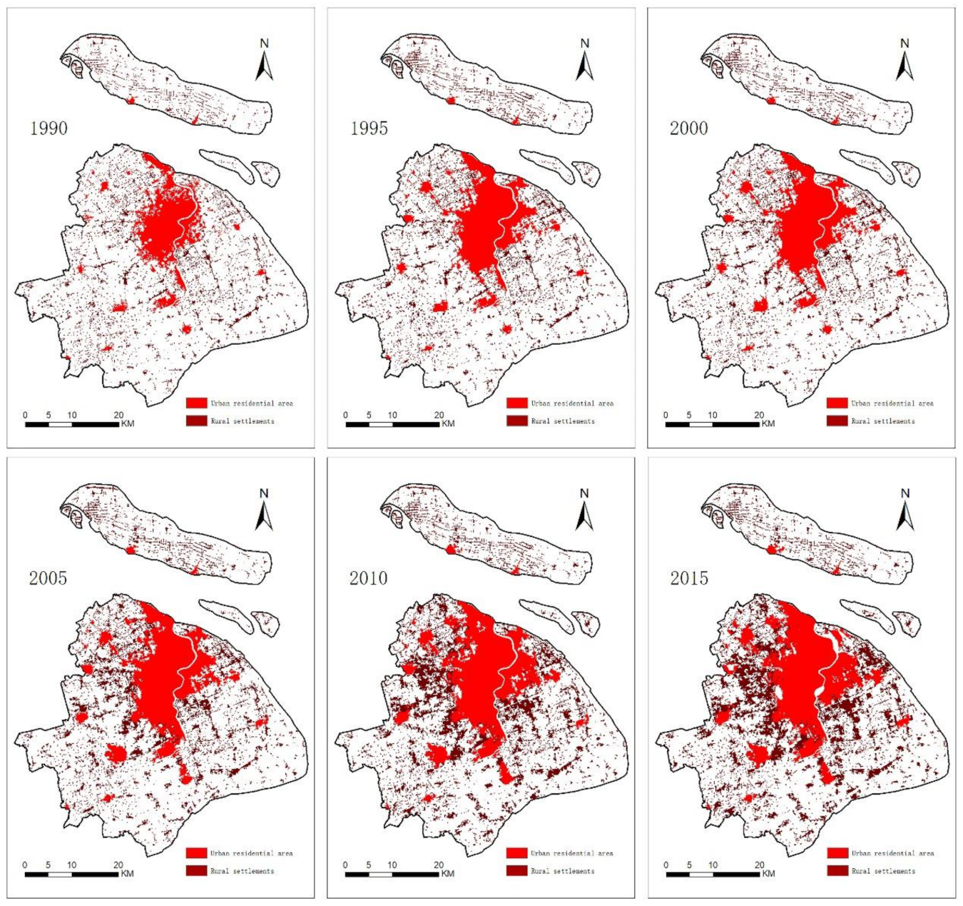
3.1. Changes in the Spatial Patterns of Residential Concentration in the Suburbs of Shanghai

In 1990, the area of urban residential land in Shanghai was 56114.31 hm2, and that of rural residential land was 42587.67 hm2. By 2015, the area of urban residential land had increased to 104906.69 hm2, and the proportion of Shanghai’s total land area covered by urban residential land had increased from 9.05% to 16.90%. Additionally, by 2015, rural residential land had increased to 105584.52 hm2, and the proportion of Shanghai’s total land area covered by rural residential land had increased from 6.87% to 17.01%. Both the increase and growth rates of rural residential land are higher than those of urban residential land.
From the perspective of changes in spatial patterns, the urban residential land in Shanghai is mainly distributed in the central urban area within the middle ring and inner ring and new cities, such as Songjiang New City, Jiading New City, Lingang New City, Jinshan New City, Qingpu New City, Nanqiao New City, and Chengqiao New City, and key towns, such as Anting Town, Pujiang Town, Gaoqiao Town, Zhujiajiao Town, Fengcheng Town, Luodian Town, Fengjing Town, Baozhen Town and Zhoupu Town, in the suburbs. Among these areas, the residential land in the central urban area shows a clear trend of expansion from the inner ring to the outer ring. The outward expansion of the new cities and key towns in the suburbs is also remarkable, with the residential areas gradually connecting with the central urban area. Overall, the pattern of spatial concentration is clear. However, the overall expansion of rural residential areas in the suburbs of Shanghai presents characteristics of linear agglomeration expansion (i.e., a development mode of expanding along the main highway trunk line and subway line and gathering at the main traffic nodes), which is closely related to the distribution of road and traffic networks, and planar agglomeration expansion (i.e., a construction mode of large-scale residential communities), which is closely related to the distribution of large-scale living facilities.

3.2. Landscape-Scale Changes in the Patterns of Residential Concentration in the Suburbs of Shanghai

To quantitatively measure the changes in the scale, form and agglomeration or dispersion degree of rural residential space, the following indexes were selected and calculated: class area (CA), number of patches (NP), mean patch size (MPS), percent of landscape (PLAND), patch density (PD), largest patch index (LPI) and landscape shape index (LSI) of the Shanghai rural residential land cover. The results show that the CA and PLAND of the rural residential land in the suburbs of Shanghai increased significantly, while the NP decreased, which reflects the obvious consolidation and concentration of rural residential areas. By 2015, the MPS increased to 44.63 hm2, the PD decreased to 0.38 (number of patches/100 hm2), and the LPI increased slightly, which reflected the expansion of large villages and towns in the suburbs of Shanghai. The LSI decreased from 86.06 in 1990 to 72.08 in 2015 (Table 4), indicating that the shape and distribution of rural residential areas changed from scattered to concentrated, and the degree of concentration increased steadily over time. Briefly, the rural residential areas in Shanghai have shown a significant dual change characterized by concentration and expansion.

3.3. Changes in the Spatial Structure of Residential Concentration in the Suburbs of Shanghai

In landscape ecology, spatial agglomeration degree, separation degree and connection degree are three important indexes to reflect changes in landscape structure. The annual variation in separation degree was abandoned in this study because it is very small. A total of 5 indicators, including the aggregation index (AI), clumpiness (CLUMPY), path cohesion index (COHESION), mean nearest distance (MNN) and connectance index (CONNECT), were selected to measure the change in the structure of rural residential land in Shanghai. Table 5 shows that the AI and CLUMPY of rural residential land in Shanghai have increased significantly. The AI increased annually from 87.62% in 1990 to 93.43% in 2015, and the CLUMPY increased from 0.87 in 1990 to 0.9208 in 2015, indicating a clear concentration of rural settlements. The COHESION and CONNECT values also show increasing trends for rural residential land, while the MNN tended to decrease overall, indicating that the natural spatial connectivity and agglomeration index of rural residential areas in Shanghai tended to improve.
In summary, from 1990 to 2015, whether from the perspective of the spatial patterns of residential areas or the landscape-scale patterns and spatial structure, the trend of residential concentration in the suburbs of Shanghai is obvious. Policy guidance, the withdrawal and merging of towns and villages, the consciousness of land saving and the consolidation of rural land are the main factors promoting the agglomeration of rural residential areas in the suburbs of Shanghai.

3.4. Time Series Change in the Residential Concentration in the Suburbs of Shanghai

According to our statistical analysis, in the suburbs of Shanghai, the average village population and number of village committee members (Table 6) have increased, which also indicates that the degree of population concentration has increased.

4. Analysis of the Spatial Distance and Orientation of the Residential Concentration in the Suburbs of Shanghai

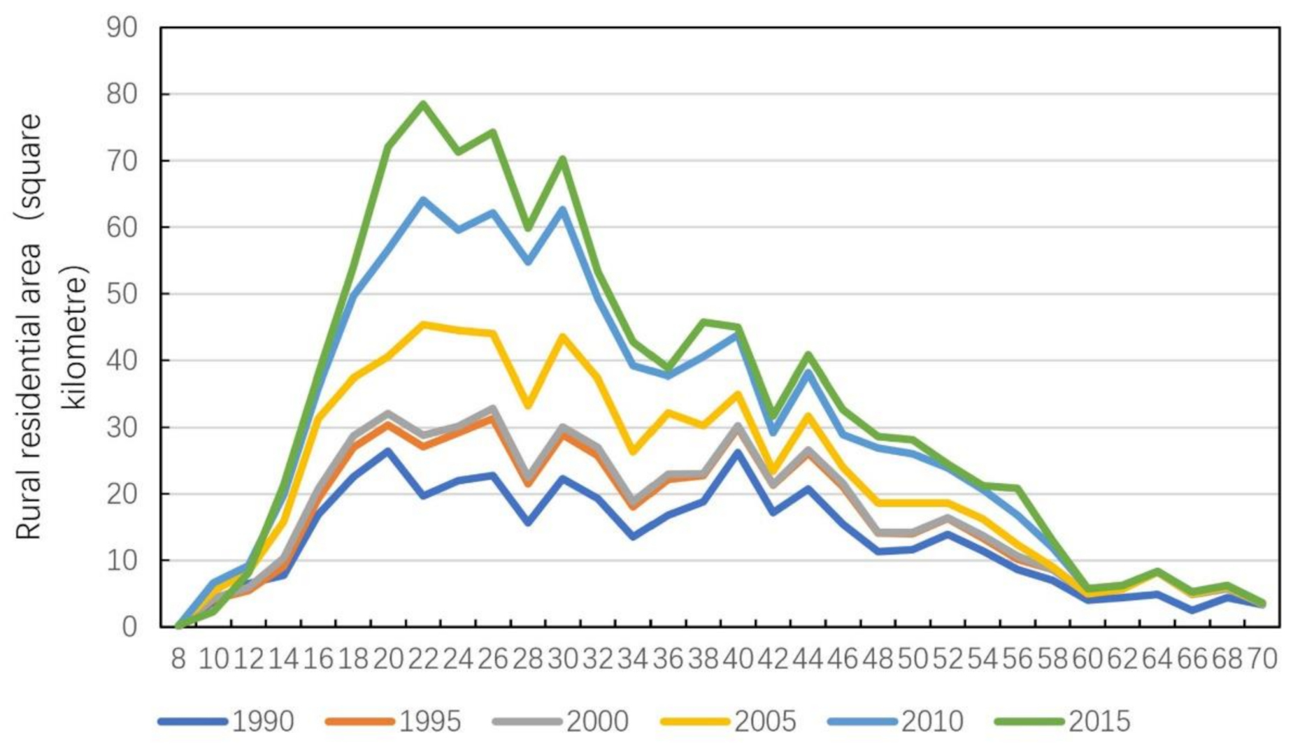
4.1. Spatial Distance Distribution Characteristics of the Rural Residential Areas in the Suburbs of Shanghai

A distance analysis was applied to construct a buffer zone consisting of concentric circles, each with a radius of 2 km, which is enough to cover the whole area of Shanghai. The coordinates of the People’s Square, the centre of the Shanghai region, were used as the centre of the buffer zone. The minimum radius of the multi-ring buffer zone is 2 km, and the maximum radius is 70 km; the buffer includes a central ring and 34 concentric rings. Overlay analyses and spatial joins were performed using the multi-ring buffers on map layers formed by raster data of the rural residential areas in 1990, 1995, 2000, 2005, 2010 and 2015. The total land area of rural settlements within each buffer was calculated, and the distribution of rural residential areas within each buffer was determined (Figure 3). The main characteristics of the spatial distributions of rural residential areas in Shanghai are as follows.
(1)
The rural residential areas in the suburbs of Shanghai begin to appear 8 km away from the city centre (the People’s Square), and the rural residential land in the innermost buffer is located in a rapidly urbanizing area. Within the 8–12 km buffer, the area of rural residential land is rapidly shrinking and being transformed into oddly shaped central cities and towns. From a large-scale perspective, the area of Shanghai’s central towns within the 12 km buffer has expanded rapidly.
(2)
In 1990, most of the rural residential areas in the suburbs of Shanghai were distributed within 14–52 km of the city centre, the distribution of rural residential areas in each ring was relatively uniform, and the land cover of the whole region was characterized by a scattered and uniform spatial distribution. As the population continues to concentrate in and converge on large-scale villages and towns, two major changes in the spatial distribution and distance of rural settlements in the suburbs of Shanghai have emerged. First, the rural population gradually converged on the suburbs, and the area with a concentrated population gradually shifted to an area 14–40 km from the city centre, showing an obvious inward concentration. Second, at a distance of 16–32 km from the city centre, the rural residential area increased rapidly and formed an expansion peak between 2000 and 2015. This finding reflects that the urbanization of Shanghai reached its peak at this point, driven by internal and external populations, and the planning and construction of many new suburban villages and towns began.
(3)
At 58 km away from the city centre, there is little change in the area of rural residential land, indicating that the population size in the outer suburbs at this distance is very small. Furthermore, there is no significant expansion of rural residential land at this distance. In fact, the change in rural residential area was significantly reduced beyond 38 km from the city centre.

4.2. Characteristics of the Spatial Orientation of Rural Residential Areas in the Suburbs of Shanghai
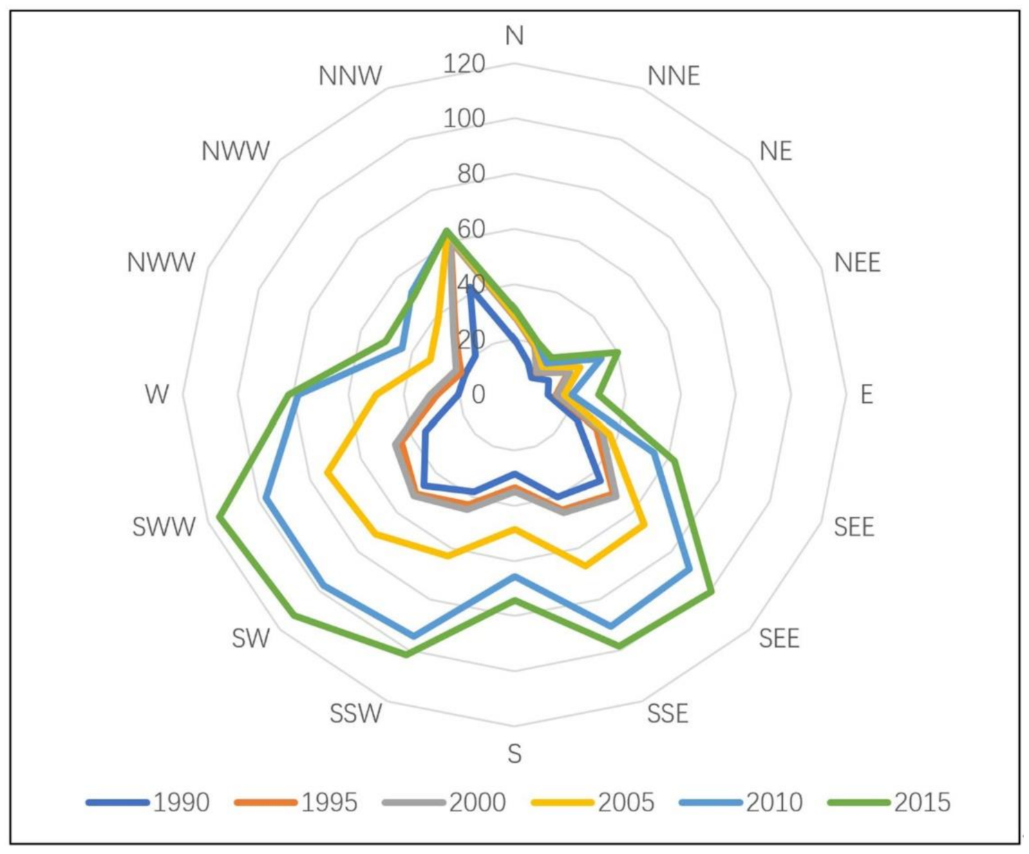
Using an equal sector method and taking the coordinates of the centre of the Shanghai region (the People’s Square) as the centre point, 16 equal sectors that had an interval angle of 22.5 degrees and covered the whole city of Shanghai were constructed. The sectors have a radius of 75 km, covering 16 azimuth areas, such as N, NNE, NE, NEE and E. Then, overlay analyses and spatial joins were performed on map layers and azimuth sectors formed by gridded data of the rural residential areas in 1990, 1995, 2000, 2005, 2010 and 2015. The total rural residential land area in each azimuth sector was counted, and the distribution of rural residential areas in each azimuth interval was determined (Figure 4). The main characteristics of the spatial distribution of the rural residential areas in Shanghai are as follows.
(1)
In 1990, most of the rural residential areas in the suburbs of Shanghai were distributed north, northwest, southeast and southwest of the People’s Square. The corresponding administrative areas were the Jiading and Baoshan districts, Pudong and Minhang districts and Songjiang district. From 1990 to 2015, there was no significant change in the overall trend of the distribution of rural settlements in Shanghai. The spatial characteristics of the rural settlements in the suburbs of Shanghai in 2015 were similar to those in 1990, and they were still concentrated in the Pudong New Area and Minhang and Songjiang districts. This also means that, as the Pudong New Area is restricted by the sea, the Songjiang district and the Minhang district are the centres of current and future rural residential concentration in Shanghai.
(2)
From 1990 to 2015, the spatial expansion of rural residential land in the suburbs of Shanghai was mainly characterized by parallel paths from the southwest to the southeast, indicating that the populations in villages and towns were concentrated in the direction of Songjiang-Minhang and Pudong.
(3)
The expansion of rural settlements in the suburbs of Shanghai, such as the Baoshan and Chongming districts and other north-western and coastal areas, increased rapidly from 1990 to 2005. However, after 2005, restricted by factors such as the sea, the growth of rural residential land in this area stagnated, and the overall change was not significant. In the direction of the Jiading and Qingpu districts, the populations of villages and towns did not undergo much expansion.

5. Discussion

Rural residential areas are relatively concentrated, and villages can be merged. As a result, several neighbouring farming villages can be demolished, and farmers can live in new communities or towns in combination with farmers from other villages or towns. This is an adjustment to the spatial layout of rural housing and a manifestation of the restructuring of urban and rural spaces. In the long run, demolishing the scattered and small-scale farming villages and guiding them to move to new or larger gathering places is undoubtedly moving the region in the right direction. In fact, urban and rural economic development is unbalanced, urban economic development needs a large amount of labour-force input, rural employment opportunities are relatively few and a large amount of labour needs to be exported. The urban infrastructure is perfect, and the education, living and medical conditions are relatively superior. The rural individual business scale is small and scattered, and farmers receive lower returns from agricultural production. It is fewer rural jobs, lower incomes and poorer infrastructure and public services that have accelerated the migration of farmers to towns and cities. The goals of farmers moving to cities and towns are to obtain more employment opportunities and income and to have access to better educational facilities and medical services. Moreover, these changes help to improve the rural environment and the quality of life for farmers and are conducive to conserving homesteading land and alleviating land-use conflicts.
However, in the process of implementing policies that aim to concentrate rural residences, there are various practical difficulties. In summary, there are two main reasons for these difficulties.
On the one hand, there are the following theoretical deficiencies: (1) New urbanization is “people-oriented” urbanization, public opinions and people’s needs are the starting point for urban development, and a high quality of life is the core goal of urban development. In some places, before the implementation of this policy, sufficient research on public opinions and on people’s needs was not conducted, and the democratic mechanism of public participation was ignored. Therefore, the implementation of this policy was not fully supported by the majority of farmers. (2) The historical and humanistic values of rural homesteads are ignored. Homesteads consist not only of material property but also of the spiritual support provided by rural “acquaintance societies.” The longer people live in a place, the more attachment they have to it. Thus, farmers generally will not easily give up ancestral homesteads unless they can be provided with better accommodations. Moreover, farmers value practical results. Rather than relying on propaganda, they prefer to see the real and convincing effects of policies. (3) Not enough attention is given to the uniqueness of farmers’ homesteads. First, there are significant differences in property nature and inheritance mode between farmers’ homesteads, rural collective lands and public facility lands, which are types of rural development land. Second, the protection of the villagers’ right to their residences has the attribute of social equity, but the principle of “one household, one house” ignores the inheritance of homesteads and the dynamic characteristics of the population. Third, the fundamental reason for the dispersion of farmers’ residences lies in the dispersion of rural means of production. Rationally, farmers shorten the distance between farming operations and reduce their operating costs.
On the other hand, in operational practice, the main shortcomings are as follows. (1) There is a mentality of eagerness for success. The scale and scope of the demolished villages are large, which leads to high demolition and resettlement costs and a large funding gap. (2) There is no coordination between the short-term interests and long-term interests of farmers. Doing demolition before construction not only increases farmers’ transition costs but also reduces their satisfaction because of the low compensation standard. (3) Some resettlement areas are not properly located or are far away from the central villages and towns, or the level of infrastructure and public services in the resettlement areas is low. (4) The resettlement policy is “one size fits all” and ignores regional differences. It is not enough to pay attention to the diversity of the operating modes of the relatively concentrated residences. Farmers have different wishes and choices, whether they are settled in towns, merged and consolidated in villages, or live in their original places of residence.
Suburban residents are living in areas more concentrated and closer to Shanghai’s downtown area, helping to share more high-quality public services. Shanghai’s high-quality public service resources (employment, education and medical care) show a rapidly decreasing trend from the central urban area to the inner suburbs and outer suburbs. The construction of more concentrated rural settlements near the central area of Shanghai will not only make it more convenient for local farmers to obtain high-quality social public resources but will also help attract immigrant talent to gather in the suburbs.

6. Conclusions and Suggestions

Since the 1990s, the rural residential areas in the suburbs of Shanghai have shown an obvious dual change characterized by concentration and diffusion; this change is manifested in a combination of linear agglomeration expansion and planar agglomeration expansion. Whether from the changes in the landscape pattern or the spatial structure, the trend of residential concentration in the suburbs of Shanghai is very clear, indicating that the strategy of rural residential concentration has achieved certain results.
The results of the changes over time show that before 1995, the trend of population diffusion in the suburbs of Shanghai was conspicuous. After 1995, there was a gradual shift into an adjustment period, during which the population agglomerated. The degree of population concentration increased rapidly from 2000 to 2010, after which it slowed again. This process of change coincides with the process of urbanization in Shanghai.
The results of the spatial distance analyses show that in 1990, the rural residential areas in the suburbs of Shanghai were mostly distributed within 14–52 km from the city centre, the distribution of residential areas in each ring was relatively uniform and the whole was characterized by a scattered and uniform spatial distribution. By 2015, the rural population gradually converged on the inner suburbs, and the centralized range gradually changed to between 16 and 32 km. In terms of spatial orientation, the rural settlements in the suburbs of Shanghai were mostly distributed north-northwest, southeast and southwest of the People’s Square in 1990; however, by 2015, the southwest and southeast directions had become the focus of the expansion of the rural settlements. The results clearly showed that the concentration of rural residents is currently in the Songjiang and Minhang districts. This region will become the new core of Shanghai’s population settlement in the future, and the growth potential of emerging cities and towns will become very large.
From the perspective of landscape pattern change combined with actual population migration and aggregation, this paper analyses the evolution process, spatial and temporal distribution characteristics and expansion direction of rural residential space in Shanghai, providing data support and technical support for clarifying the spatial form and development law of Shanghai suburbs and formulating the overall rural revitalization strategic plan and the layout of villages and towns. For example, with the redevelopment of Lingang New City, this area is becoming more attractive to population and industry and will become a new growth pole for Shanghai. Baoshan District, north of Shanghai, is also facing new development opportunities with the relocation of Baosteel’s production base. However, Jiading district in northwest Shanghai still needs to find new growth points to attract population and industry.
The layout of villages in the suburbs of Shanghai should be classified and optimized. Based on the premise of insisting on relatively concentrated residences for farmers, the scope of retaining (i.e., protecting), withdrawing and merging villages outside the development boundary in all towns and townships throughout the city should be clarified. Preferably, farming villages in ecologically and environmentally sensitive areas would be dismantled, and comprehensive environmental control areas would be established in the 2035 Urban Master Plan for Shanghai. Three types of residential areas are planned for and constructed; namely, urban centralized settlement areas (within the development boundary), rural centralized merging points (outside the development boundary) and populated rural reservations (outside the development boundary), to guarantee living space for farmers and optimize the overall spatial layout of rural areas in the city.
It is necessary to focus on building new planned towns in suburban areas in south-western and south-eastern Shanghai. First, considering the positive effect of the urban traffic network on the construction of new suburban towns, the connection of the traffic network between the central city and key new and planned towns in these regions should be strengthened. Second, the development zones in the region should be managed, the industrial area should be optimized, policy incentives should be used to promote the entry of target enterprises and the scope of characteristic regional urban industries should be expanded. Third, there should be a focus on the construction of universities and scientific research institutes in the region to actively attract exceptional professionals. Fourth, the new suburban cities should be given management authority. In particular, the people who come to Shanghai to study and start businesses should effectively manage their companies and actively provide policy support in terms of residences [62].
The key to solving various challenges and problems arising from the centralized relocation and resettlement of rural residents is continuous innovation and strict implementation of various systems and measures of homestead replacement. Rural homestead replacement must effectively establish farmers’ communication systems, institutional linkage systems, residents’ meeting systems, public opinion support systems, property rights distribution systems and social security systems. However, it is also necessary to clarify the relationship between property rights, ownership and land income distribution after land replacement [63]. Only when a plan for publicity is in place, the connection is orderly, a thorough discussion has occurred, the property rights are clear and the welfare of the people is stable can the movement of village dwellers into towns be promoted. In particular, the current homestead replacement practice is based on the independent choices of people living in villages, and the government must strictly abide by institutional measures and innovate working methods according to local conditions. For example, there should be a 100% contract rate for collective linkage bonuses; special resettlement subsidies should be granted for the families of people who are elderly, weak or disabled; and people moving from their villages should be allowed to personalize the design of their new house. These innovative methods will promote the overall relocation and resettlement of rural households in the region and contribute to the concentration of rural residential areas. In addition, subsequent social security for relocated rural households needs to be optimized in the current homestead replacement plant for the suburbs of Shanghai, and the employment and social welfare of the relocated farmers should be strictly guaranteed.
In this paper, the suburbs of Shanghai as a whole space are analysed. In future studies, we will classify suburban spaces, such as interlocking regions with clear cores, interlocking regions without clear cores, peripheries with clear cores and peripheries without clear cores, to propose more specific planning and policy guidance for different types of rural spaces. In addition, it is necessary to integrate population and residential concentration with industrial agglomeration, land use intensification and traffic network expansion and systematically study the coupling and coordinated development relationship among them.

Author Contributions

Conceptualization, Y.S. and H.R.; methodology, H.R.; software, T.T.; validation, H.R.; formal analysis, H.R., Y.S.; investigation, H.R.; resources, Y.S.; data curation, H.R., X.G.; writing—original draft preparation, Y.S, H.R.; writing—review and editing, Y.S.; visualization, X.G.; supervision, Y.S.; project administration, Y.S.; funding acquisition, Y.S. All authors have read and agreed to the published version of the manuscript.

Funding

This research was supported by the Key Projects for Shanghai General Land Use Planning Revision (2015(D)-002(F)-11).

Conflicts of Interest

The authors declare no conflict of interest.

References

  1. Flaga, M. Demographic consequences of suburbanization in selected towns in the eastern Borderlands of Poland. Bull. Geogr. Socio-Econ. Ser. 2012. [Google Scholar] [CrossRef] [Green Version]
  2. Zhang, B. A Study on Population Agglomeration of Outer Suburbs of Shanghai under the Construction of New Suburbs. Master’s Thesis, East China Normal University, Shanghai, China, 2007. (In Chinese). [Google Scholar]
  3. Huang, J. An empirical test on the spatial characteristics of Shanghai suburban population agglomeration. Rev. Shanghai City Plan. 2017, 7, 84–89. (In Chinese) [Google Scholar]
  4. Cha, B.; Ji, F.; Wang, C. Analysis on the current situation of population agglomeration in Shanghai suburban new towns. Stat. Sci. Pract. 2012, 31, 23–25. (In Chinese) [Google Scholar]
  5. Ihara, R. Heterogeneous labor and agglomeration over generations. Reg. Sci. Urban Econ. 2019, 77, 367–381. [Google Scholar] [CrossRef] [Green Version]
  6. Combes, P.P.; Démurger, S.; Lim, S. Unequal migration and urbanisation gains in China. J. Dev. Econ. 2020, 142, 102328. [Google Scholar] [CrossRef]
  7. Shi, Y. A research on industry-city integration: Review and new exploration. Urban Plan. Forum 2016, 231, 73–78. (In Chinese) [Google Scholar]
  8. Korpi, M.; Clark, W.A.V. Migration and occupational careers: The static and dynamic urban wage premium by education and city size. Pap. Reg. Sci. 2019, 98, 555–574. [Google Scholar] [CrossRef] [Green Version]
  9. Zhang, M. Research on the Development of Shanghai Suburban New Town. Master’s Thesis, Fudan University, Shanghai, China, 2011. (In Chinese). [Google Scholar]
  10. Shi, Y.; Chen, Y. New city planning and construction in Shanghai: Retrospective and prospective. Int. J. Urban Sci. 2016, 20, 49–72. [Google Scholar] [CrossRef]
  11. Zhang, T.; Zhou, S. Evaluation on the construction effect of Shanghai suburban New city. Urban Probl. 2014, 33, 31–35. (In Chinese) [Google Scholar]
  12. Governa, F.; Sampieri, A. Urbanisation processes and new towns in contemporary China: A critical understanding from a decentred view. Urban Stud. 2020, 57, 366–382. [Google Scholar] [CrossRef]
  13. Meng, Q. Study on the Life Style of the Migrant Population in Shanghai; Shanghai Academy of Social Sciences Press: Shanghai, China, 2009. (In Chinese) [Google Scholar]
  14. Howell, R.A. Promoting lower-carbon lifestyles: The role of personal values, climate change communications and carbon allowances in processes of change. Environ. Educ. Res. 2014, 20, 434–435. [Google Scholar] [CrossRef] [Green Version]
  15. Apergis, N.; Li, J. Population and lifestyle trend changes in China: Implications for environmental quality. Appl. Econ. 2016, 48, 5246–5256. [Google Scholar] [CrossRef]
  16. Zhang, K. The correlation research between lifestyle changes and evolution of residential communities-Based on a survey of Shanghai, China. Archit. Res. 2020, 22, 1–11. [Google Scholar]
  17. Losada, H.; Martínez, H.; Vieyra, J.; Pealing, R.; Zavala, R.; Cortés, J. Urban agriculture in the metropolitan zone of Mexico City: Changes over time in urban, suburban and peri-urban areas. Environ. Urban 1998, 10, 37–54. [Google Scholar] [CrossRef]
  18. Henderson, V. The urbanization process and economic growth: The so-what question. J. Econ. Growth 2003, 8, 47–71. [Google Scholar] [CrossRef]
  19. Thuo, A.D.M. Urbanization in Nairobi’s rural-urban fringe: Consequences of land-use conversion. Acta Hortic. 2014, 1021, 195–208. [Google Scholar] [CrossRef]
  20. Elmqvist, T.; Fragkias, M.; Goodness, J.; Güneralp, B.; Marcotullio, P.J.; McDonald, R.I.; Parnell, S.; Schewenius, M.; Sendstad, M.; Seto, K.C.; et al. Urbanization, Biodiversity and Ecosystem Services: Challenges and Opportunities: A Global Assessment; Springer: Amsterdam, The Netherlands, 2013. [Google Scholar]
  21. Fleisher, B.M. Urbanization in China. China Econ. Rev. 2015, 35, 219. [Google Scholar] [CrossRef]
  22. Liu, Y.; Li, S. Research on the urbanization of rural settlement in city outskirt in China. Open J. Soc. Sci. 2017, 5, 37–50. [Google Scholar] [CrossRef] [Green Version]
  23. Lu, J.; Li, B.; Li, H. The influence of land finance and public service supply on peri-urbanization: Evidence from the counties in China. Habitat Int. 2019, 92, 102039. [Google Scholar] [CrossRef]
  24. Duijne, R.J. Why India’s urbanization is hidden: Observations from “rural” Bihar. World Dev. 2019, 123, 104610. [Google Scholar] [CrossRef]
  25. Coward, R.T.; Cutler, S.J. The concept of a continuum of residence: Comparing activities of daily living among the elderly. J. Rural Stud. 1988, 4, 159–168. [Google Scholar] [CrossRef]
  26. Sharp, K.; Le Billon, P.; Zerriffi, S. Land reforms and voluntary resettlement: Household participation and attrition rates in Malawi. J. Peasant Stud. 2019, 46, 956–982. [Google Scholar] [CrossRef]
  27. Pelek, D. Ethnic residential segregation among seasonal migrant workers: From temporary tents to new rural ghettos in southern Turkey. J. Peasant Stud. 2020. [Google Scholar] [CrossRef]
  28. Yang, Q.; Cai, Y. Housing property redistribution and elite capture in the redevelopment of urban villages: A case study in Wuhan, China. J. Clean. Prod. 2020, 262, 121192. [Google Scholar] [CrossRef]
  29. Liu, L.; Gao, X.; Zhuang, J.; Wu, W.; Yang, B.; Cheng, W.; Xiao, P.; Yao, X.; Deng, O. Evaluating the lifestyle impact of China’s rural housing land consolidation with locational big data: A study of Chengdu. Land Use Policy 2020, 96, 104623. [Google Scholar] [CrossRef]
  30. Yu, C. Improvement of rural human settlements and rural planning strategies from the perspective of public goods. J. Landsc. Res. 2019, 11, 51–56. [Google Scholar]
  31. Wang, Z.; Liu, J.; Ming, J. Owned a house in an urban destination or made housing investments in the hometown? Determinants of rural migrants’ housing attainments in China. J. Plan. Lit. 2020, 35, 354. [Google Scholar] [CrossRef]
  32. Zubarevich, N.V. Transformation of the rural settlement pattern and social services network in rural areas. Reg. Res. Russ. 2013, 3, 221–233. [Google Scholar] [CrossRef]
  33. Long, H. Land consolidation and rural spatial restructuring. Acta Geogr. Sin. 2013, 68, 1019–1028. (In Chinese) [Google Scholar]
  34. Long, T.; Shi, X.; Liu, J.; Sun, Y.; Ma, J. Centralized residence pattern of peasants in Shanghai. Acta Agric. Shanghai 2018, 34, 109–114. (In Chinese) [Google Scholar]
  35. Wen, Y.; Zhang, Z.; Liang, D.; Xu, Z. Rural residential land transition in the Beijing-Tianjin-Hebei region: Spatial-temporal patterns and policy implications. Land Use Policy 2020, 96, 104700. [Google Scholar] [CrossRef]
  36. Benz, U.C.; Hofmann, P.; Willhauck, G.; Lingenfelder, I.; Heynen, M. Multi-resolution, object-oriented fuzzy analysis of remote sensing data for GIS-ready information. ISPRS J. Photogramm. Remote Sens. 2004, 58, 239–258. [Google Scholar] [CrossRef]
  37. Benediktsson, J.A.; Chanussot, J.; Moon, W.M. Advances in very-high-resolution remote sensing. Proc. IEEE 2013, 101, 566–569. [Google Scholar] [CrossRef]
  38. Huang, X.; Wang, Y.; Li, J.; Chang, X.; Cao, Y.; Xie, J.; Gong, J. High-resolution urban land-cover mapping and landscape analysis of the 42 major cities in China using ZY-3 satellite images. Sci. Bull. 2020, 65, 1039–1048. [Google Scholar] [CrossRef]
  39. Campagna, M.; Matta, A. Geoinformation technologies in sustainable spatial planning: A geodesign approach to local land-use planning/second international conference on remote sensing and geoinformation of the environment (RSCy2014). Int. Soc. Opt. Photon. 2014, 9229, 92290T. [Google Scholar]
  40. Malczewski, J.; Rinner, C. Multicriteria Decision Analysis in Geographic Information Science; Springer: New York, NY, USA, 2015. [Google Scholar]
  41. Jesinghaus, J. Measuring European environmental policy performance. Ecol. Indic. 2012, 17, 29–37. [Google Scholar] [CrossRef]
  42. Bottero, M. A multi-methodological approach for assessing sustainability of urban projects. Manag. Environ. Qual. 2015, 26, 138–154. [Google Scholar] [CrossRef]
  43. Assumma, V.; Bottero, M.; Monaco, R. Landscape economic attractiveness: An integrated methodology for exploring the rural landscapes in Piedmont (Italy). Land 2019, 8, 105. [Google Scholar] [CrossRef] [Green Version]
  44. Shi, Y.; Yang, B. Reflections on and Countermeasures against implementing strategy of “Three Concentrations” in suburban districts of Shanghai. J. Tongji Univ. Soc. Sci. Sect. 2004, 15, 7–12. (In Chinese) [Google Scholar]
  45. Yuan, Y. “Three Concentrations” strategy and the course of urbanization in the suburbs of Shanghai. Shanghai Rural Econ. 2016, 46, 34–38. (In Chinese) [Google Scholar]
  46. Xue, L.; Chen, B. Discussion on “Three Concentrations”. Shanghai Rural Econ. 1996, 16, 17–18. (In Chinese) [Google Scholar]
  47. Zhang, J.; Zhao, M. Theory and Practice of New City Planning; China Architecture & Business Press: Beijing, China, 2005. (In Chinese) [Google Scholar]
  48. Yan, R. Pilot implementation of public Policy: A case study of large-scale residential communities in Shanghai. China Real Estate 2019, 26, 32–41. (In Chinese) [Google Scholar]
  49. Shi, Y. Review on the urban-rural integration. Urban Plan. Forum 2003, 143, 49–54. (In Chinese) [Google Scholar]
  50. Ye, X. China’s urban-rural integration policies. J. Curr. Chin. Aff. 2009, 4, 117–143. [Google Scholar] [CrossRef] [Green Version]
  51. Zheng, Z.; Yu, G. Study on the mechanism evolution of China’s urban-rural integration development planning and its land system in practice. Energy Proc. 2011, 15, 1852–1858. [Google Scholar] [CrossRef] [Green Version]
  52. Hui, Q.; Cecilia, W. Master planning under urban-rural integration: The case of Nanjing, China. Urban Police Res. 2012, 30, 403–421. [Google Scholar]
  53. Shanghai Municipal People’s Government. Some Opinions on Improving the Living and Living Conditions of Peasants in Shanghai and the Countryside Style and Further Promoting the Relatively Concentrated Living of Peasants; Shanghai Government Regulation 2019 No. 21; Shanghai Government: Shanghai, China, 2019. Available online: http://www.shanghai.gov.cn/nw2/nw2314/nw2319/nw41149/u83aw6975.html (accessed on 20 September 2020).
  54. Crutzen, P.J. Human impact on climate has made this the “Anthropocene Age”. New Perspect. Quart. 2005, 22, 14–16. [Google Scholar] [CrossRef]
  55. Livingston, J.E.; Lövbrand, E.; Olsson, J.A. From climates multiple to climate singular: Maintaining policy-relevance in the IPCC synthesis report. Environ. Sci. Policy 2018, 90, 83–90. [Google Scholar] [CrossRef]
  56. Parnell, S. Defining a global urban development agenda. World Dev. 2016, 78, 529–540. [Google Scholar] [CrossRef]
  57. Bai, X.; Surveyer, A.; Elmqvist, T.; Gatzweiler, F.W.; Guneralp, B.; Parnell, S.; Prieur-Richard, A.-H.; Shrivastava, P.; Siri, J.G.; Stafford-Smith, M.; et al. Defining and advancing a systems approach for sustainable cities. Curr. Opin. Environ. Sustain. 2016, 23, 69–78. [Google Scholar] [CrossRef]
  58. Jaeger, J.A.G. Landscape division, splitting index, and effective mesh size: New measures of landscape fragmentation. Landsc. Ecol. 2000, 15, 115–130. [Google Scholar] [CrossRef]
  59. Zhou, D.; Zhang, J.; Cheng, W. Analysis on the spatial pattern of land use in urban rural fringe zone—A case study of Xigu district in Lanzhou city. J. Landsc. Res. 2009, 1, 26–30. [Google Scholar]
  60. Fan, I.; Tian, G. The change of land use and landscape pattern in Shanghai from 1995 to 2015. Bull. Soil Water Conserv. 2018, 38, 287–292. (In Chinese) [Google Scholar]
  61. Yu, D.; Qiao, J.; Shi, P. Spatio-temporal patterns, relationships, and drivers of China’s agricultural ecosystem services from 1980 to 2010: A multi-scale analysis. Landsc. Ecol. 2018, 33, 575–595. [Google Scholar] [CrossRef]
  62. Shen, J.; Wu, F. The suburb as a space of capital accumulation: The development of new towns in Shanghai, China. Antipode 2017, 49, 761–780. [Google Scholar] [CrossRef]
  63. Cruz, R.B.C.; Marins, K.R.C. Urban planning and popular participation: A diagnosis of the effectiveness of participatory processes applied to the revision of São Paulo master plan. Habitat Int. 2019, 88, 101987. [Google Scholar] [CrossRef]
Figure 1. Spatial distribution of the urban and rural residential land area in Shanghai from 1990 to 2015. Data source: The primary data sources were downloaded from the Geographical Information Monitoring Cloud Platform (http://www.dsac.cn/).
Land 09 00367 g001
Figure 2. Geographical location of Shanghai city.
Land 09 00367 g002
Figure 3. Statistical chart of the spatial variation in the distances between rural residential areas in the suburbs of Shanghai.
Land 09 00367 g003
Figure 4. Statistical chart of the spatial changes in the rural residential distribution by azimuth in the suburbs of Shanghai.
Land 09 00367 g004
Table 1. The main policy documents for promoting rural residential concentration in the suburbs of Shanghai since 2000.
Release TimeName of Policy DocumentPolicy PrioritiesKey Policy Objectives
2003Outline for Action on Accelerating the “Three Concentrations” in the Suburbs of ShanghaiTo accelerate the concentration of land in large-scale operations, industries in industrial parks, and rural residents in cities and towns—vigorously incorporating natural villages, relying on industrial agglomeration to promote population concentration, and relying on modern transportation networks to accelerate the construction of key cities and towns.Improving the strength and level of the suburb as a whole, making the suburb become the growth pole of Shanghai’s economic development, realizing the overall and coordinated development of the central city and the suburb, and accelerating the urban-rural integration development.
2010Some Opinions on the Implementation of the Policy of Linking the Increase and Decrease of Urban and Rural Construction Land in Shanghai to Promote the Pilot Work of Replacing Farmer HomesteadsThrough the development and circulation of the surplus index of construction land, the funds needed for the pilot project of homestead replacement are guaranteed to carry out the work of replacing farmers’ homesteads and withdrawing and merging scattered villages.Revitalizing rural collective construction land, increasing the effective area of cultivated land, controlling the disorderly development of rural housing sites, and improving farmers’ living conditions and environmental quality.
April 2016Opinions of the People’s Government of Shanghai Municipality on Promoting the Concentration of Farmer Residences in Cities and TownsPriority will be given to concentrating rural residents in unincorporated villages with no more than 10 households in purely rural areas.Encouraging and guiding farmers to live in cities and towns, improving their living conditions, and effectively raising the level of urban-rural integrated development in Shanghai.
5 May 2019Several Opinions on Effectively Improving the Living Conditions of Farmers and Rural Lifestyle in Shanghai and Further Promoting the Relatively Concentrated Residences of FarmersTo promote the implementation of relatively centralized living in the areas along expressways, high-speed railways, and high-voltage lines in the areas of ecological sensitivity, comprehensive environmental improvement, and in the areas outside the planned rural residential areas.Encouraging and guiding farmers to live in relatively concentrated communities, conserving land resources, effectively improving their living conditions and rural landscape, and constantly enhancing their sense of gain, happiness, and security. By 2022, 50,000 farmers will live in relatively concentrated communities.
25 June 2019Measures for the Administration of Rural Villagers’ Housing Construction in ShanghaiSpecific requirements are put forward for the standards and construction management of centralized residential housing construction.Strengthening management of housing construction for villagers, guiding rural housing construction to make rational and economical use of land resources, and promoting the implementation of the strategy for rural revitalization.
Table 2. Landscape spatial pattern index.
IndexFormulaExplanation
Class area
(CA)
C A = j = 1 n a i j × 1 10000 a i j is the area of patch i j , divided by 10,000, and that’s going to be h m 2
Number of patches
(NP)
N P = n i n i is the number of patches contained in type i
Mean patch size
(MPS)
M P S = C A n i C A is the type of patches area, n i is the number of patches of type i
Path density
(PD)
P D = n i A 10000 100 n i is the number of patches of type i , A is the total area of all landscapes
Percent of landscape
(PLAND)
P L A N D = P i = j = 1 n a i j A 100 a i j is the area of patch i j , A is the total area of all landscapes
Largest path index
(LPI)
L P I = max a i j A 100 a i j is the area of patch i j , A is the total area of all landscapes
Landscape shape index
(LSI)
L S I = e i m i n e i 10000 100 e i is the total edge length or perimeter of type patch, and
m i n e i is the possible minimum value of e i
Table 3. Landscape spatial structure index.
IndexFormulaExplanation
Aggregation index
(AI)
A I = i = 1 m g i i max g i i p i 100 g i i is the number of similar adjacent patches of the corresponding landscape type; p i is the area ratio of type patches
Clumpiness
(CLUMPY)
C L U M P Y = G i P i 1 P i
G i = g i i ( k = 1 m g i k ) m i n e i
g i i is the number of nodes between patch types based on the double method; e i is the perimeter of patches
Mean nearest distance
(MNN)
M N N = j = 1 n m i n ( d i j ) m i d i j is the distance between patches i and j ;   m i is the number of type patches with the closet distance
Landscape division index
(DIVISION)
D I V I S I O N = 1 j = 1 n a i j A 2 a i j is the area of patch i j ;   A is the total number of landscape grids
Connectance index
(CONNECT)
C O N N E C T = j = k n c j k n i n i 1 2 100 c j k is the number of connections between patch j and patch k related to patch type i ; n i is the number of patches i
Path cohesion index
(COHESION)
C O H E S I O N = 1 j = 1 n p i j j = 1 n p i j a i j × 1 1 A 1 × 100 p i j   is the perimeter of patch i j ;   a i j is the area of patch i j ; A is the total number of landscape grids
Table 4. Landscape pattern indexes and their changes in rural residential areas in Shanghai.
YearCA (hm2)NP (No.)MPS (hm2)PLAND (%)PD (No./100 hm2)LPI (%)LSI (%)
199042,587.67324813.116.870.520.0986.06
199553,394.69263320.288.610.420.2082.42
200055,311.13284019.488.920.460.2082.94
200571,980.38275811.6126.100.440.3177.60
201095,265.56246038.7315.350.401.5875.03
2015105,584.52236644.6317.010.381.7672.08
Table 5. Landscape structure indexes and their changes in rural residential areas in Shanghai.
YearAICLUMPYCOHESIONMNN (m) CONNECT
199087.620.8794.63298.620.1542
199589.41470.884296.0482324.330.1739
200089.5290.88596.0514314.570.1655
200591.42490.90396.9385304.730.1684
201092.79790.914998.2729296.860.1886
201593.43050.920898.5225290.100.1942
Table 6. Changes in the average village population and number of village committee members in the suburbs of Shanghai.
Year199019952000200520102015
The average village population (person)26,80331,96145,32072,25171,45676,531
The average number of village committee members (person)186722182491396945615237
Notes: Due to a lack of data, the value for 2015 was calculated by a curve fitting method with data from 1995 to 2012. Data source: Shanghai Suburb Statistical Yearbook.

