Predicted Maps for Soil Organic Matter Evaluation: The Case of Abruzzo Region (Italy)
Abstract
1. Introduction
2. Materials and Methods
2.1. Study Area
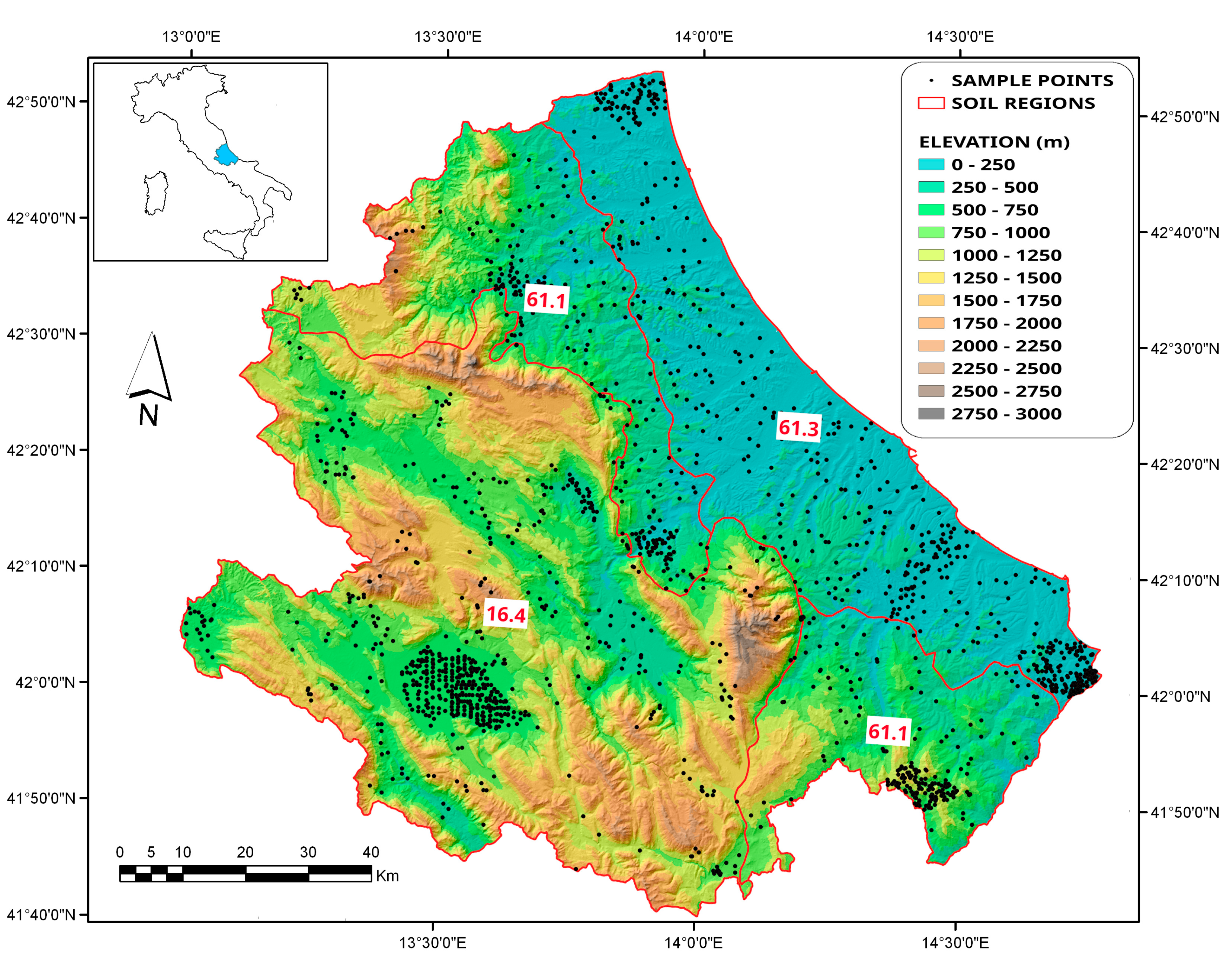
- SR61.3: Hills of central and southern Italy on Pliocene and Pleistocene marine deposits and Holocene alluvial sediments along the Adriatic Sea;
- SR 61.1: Apennine and anti-Apennine relieves on sedimentary rocks (Tertiary arenaceous marly flysch) of central and southern Italy; and
- SR16.4: Apennine relieves on Mesozoic and Tertiary limestone, dolomite, and marl, and intra-mountain plains [36].
2.2. Data Collection
- Elevation (ELEV);
- slope gradient (SLOPE);
- curvature plan and profile (PLANC and PROFC), obtained from the second derivative of the maximum slope direction and the perpendicular one respectively [43];
- solar radiation (SOLAR);
- Topographic Wetness Index (TWI);
- flow accumulation (FLOWACC), which represents the contributing area (i.e., the surface over which water from rainfall, snowfall, etc. can be aggregated) [44]; and
- Stream Power Index (SPI).
2.3. Data Processing and Validation of Results
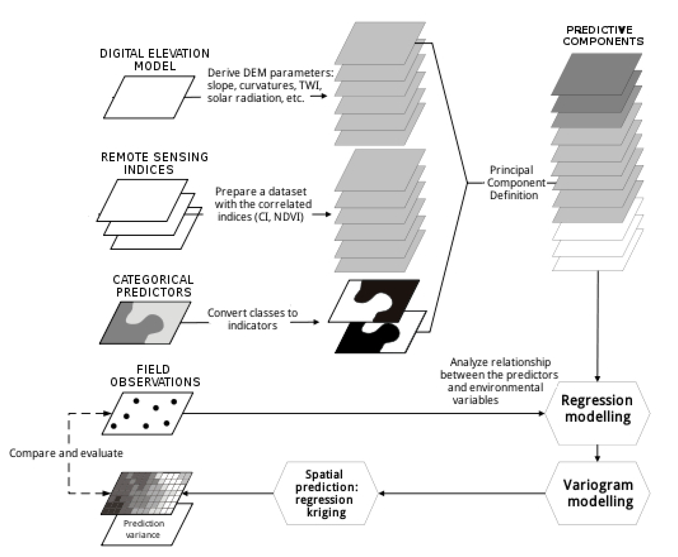
- set up and import predictor data layers (land-surface parameters and soil subsystems map);
- match soil samples in the training dataset with land-surface parameters and build the regression matrix. Since using the calculated parameters and indices directly as predictors may cause multicollinearity and redundancy effects, the covariates were transformed in principal components (PCs) [51]. Eleven orthogonal and independent components were defined, and the choice of predictors for each variable was then performed by a stepwise regression, considering only the components significant at p < 0.001;
- linear regression analysis and derivation of the regression residuals, resolving the regression coefficients by means of a maximum likelihood algorithm [52];
- analysis of residuals for detecting spatial autocorrelation, and fitting of the theoretical variogram models;
- run the interpolation; and
- visualization and validation of the results using the test dataset.
3. Results and Discussion
4. Conclusions
Supplementary Materials
Author Contributions
Funding
Acknowledgments
Conflicts of Interest
References
- Hagemann, N.; Álvaro-Fuentes, J.; Siebielec, G.; Castañeda, C.; Bartke, S.; Dietze, V.; Maring, L.; Arrúe, J.L.; Playán, E.; Plaza-Bonilla, D.; et al. Review of Economic, Social and Environmental Impacts and Implementation Barriers for Soil Protection and Sustainable Management Measures for Arable Land across the EU; European Commission, DG Environment, Technical Report, 2019; Contract no. ENV.D.1/SER/2016/0041; European Commission: Luxembourg, 2016. [Google Scholar]
- Gregorich, E.G.; Carter, M.R.; Angers, D.A.; Monreal, C.M.; Ellert, B.H. Toward minimum data set to assess soil organic matter quality in agricultural soils. Can. J. Soil Sci. 1994, 74, 885–901. [Google Scholar] [CrossRef]
- Food and Agriculture Organization of the United Nations. FAO Voluntary Guidelines for Sustainable Soil Management; FAO: Rome, Italy, 2017; p. 16. Available online: http://www.fao.org/3/a-bl813e.pdf (accessed on 18 August 2020).
- Smith, P.; Fang, C.M.; Dawson, J.J.C.; Moncrieff, J.B. Impact of global warming on soil organic carbon. Adv. Agron. 2008, 97, 1–43. [Google Scholar]
- Lützow, M.V.; Kögel-Knabner, I.; Ekschmitt, K.; Matzner, E.; Guggenberger, G.; Marschner, B.; Flessa, H. Stabilization of soil organic matter in temperate soils: Mechanisms and their relevance under different soil conditions—A review. Eur. J. Soil Sci. 2006, 57, 426–445. [Google Scholar] [CrossRef]
- Batjes, N.H. Total carbon and nitrogen in the soils of the world. Eur. J. Soil Sci. 1996, 47, 151–163. [Google Scholar] [CrossRef]
- Friedlingstein, P.; Jones, M.W.; O’Sullivan, M.; Andrew, R.M.; Hauck, J.; Peters, G.P.; Peters, W.; Pongratz, J.; Sitch, S.; Le Quéré, C.; et al. Global Carbon Budget 2019. Earth Syst. Sci. Data 2019, 11, 1783–1838. [Google Scholar] [CrossRef]
- Freibauer, A.; Rounsevell, M.D.A.; Smith, P.; Verhagen, J. Carbon sequestration in the agricultural soils of Europe. Geoderma 2004, 122, 1–23. [Google Scholar] [CrossRef]
- Baker, J.M.; Ochsner, T.E.; Venterea, R.T.; Griffis, T.J. Tillage and soil carbon sequestration—What do we really know? Agric. Ecosyst. Environ. 2007, 118, 1–5. [Google Scholar] [CrossRef]
- Lal, R. Soil carbon sequestration to mitigate climate change. Geoderma 2004, 123, 1–22. [Google Scholar] [CrossRef]
- Smith, P.; Andren, O.; Karlsson, T.; Perala, P.; Regina, K.; Rounsevell, M.; Van Wesemael, B. Carbon sequestration potential in European croplands has been overestimated. Glob. Chang. Biol. 2005, 11, 2153–2163. [Google Scholar] [CrossRef]
- Lal, R. Challenges and opportunities in soil organic matter research. Eur. J. Soil Sci. 2009, 60, 158–169. [Google Scholar] [CrossRef]
- Francaviglia, R.; Renzi, G.; Rivieccio, R.; Marchetti, A.; Piccini, C. Spatial analysis and prediction of soil organic carbon in Friuli Venezia Giulia Region (Northern Italy). Geoinfor. Geostat. Overv. 2014, 2. [Google Scholar] [CrossRef]
- Zdruli, P.; Jones, R.J.A.; Montanarella, L. Organic Matter in the Soils of Southern Europe. European Soil Bureau Technical Report; EUR 21083 EN; Office for Official Publications of the European Communities: Luxembourg, 2004. [Google Scholar]
- Marchetti, A.; Piccini, C.; Francaviglia, R.; Santucci, S.; Chiuchiarelli, I. Estimating soil organic matter content by regression kriging. In Digital Soil Mapping: Bridging Research, Environmental Application, and Operation; Boettinger, J.L., Howell, D.W., Moore, A.C., Hartemink, A.E., Kienast Brown, S., Eds.; Springer: Dordrecht, The Netherlands, 2010; pp. 241–254. [Google Scholar]
- Marchetti, A.; Piccini, C.; Francaviglia, R.; Mabit, L. Spatial distribution of soil organic matter using geostatistics: A key indicator to assess soil degradation status in central Italy. Pedosphere 2012, 22, 230–242. [Google Scholar] [CrossRef]
- Bot, A.; Benites, J. The Importance of Soil Organic Matter. Key to Drought-Resistant Soil and Sustained Food Production; FAO Soil Bulletin: Rome, Italy, 2005; Available online: http://www.fao.org/docrep/009/a0100e/a0100e00.htm (accessed on 18 August 2020).
- Fang, X.; Xue, Z.; Li, B.; An, S. Soil organic carbon distribution in relation to land use and its storage in a small watershed of the Loess Plateau, China. Catena 2012, 88, 6–13. [Google Scholar] [CrossRef]
- Ping, J.L.; Dobermann, A. Variation in the precision of soil organic carbon maps due to different laboratory and spatial prediction methods. Soil Sci. 2006, 171, 374–387. [Google Scholar]
- Mueller, T.G.; Pierce, F.J. Soil carbon maps: Enhancing spatial estimates with simple terrain attributes at multiple scales. Soil Sci. Soc. Am. J. 2003, 67, 258–267. [Google Scholar] [CrossRef]
- Dobos, E.; Carré, F.; Hengl, T.; Reuter, H.I.; Tóth, G. Digital Soil Mapping As a Support to Production of Functional Maps; EUR 22123 EN; Office for Official Publications of the European Communities: Luxemburg, 2006. [Google Scholar]
- McBratney, A.B.; Mendonça Santos, M.L.; Minasny, B. On digital soil mapping. Geoderma 2003, 117, 3–52. [Google Scholar] [CrossRef]
- Marchetti, A.; Piccini, C.; Francaviglia, R.; Santucci, S.; Chiuchiarelli, I. Evaluation of soil organic matter content in Teramo province, Central Italy. Adv. GeoEcol. 2008, 39, 345–356. [Google Scholar]
- McBratney, A.; Odeh, I.; Bishop, T.; Dunbar, M.; Shatar, T. An overview of pedometric techniques for use in soil survey. Geoderma 2000, 97, 293–327. [Google Scholar] [CrossRef]
- Adhikari, K.; Hartemink, A.E.; Minasny, B.; Bou Kheir, R.; Greve, M.B.; Greve, M.H. Digital Mapping of Soil Organic Carbon Contents and Stocks in Denmark. PLoS ONE 2014, 9, e105519. [Google Scholar] [CrossRef]
- Guo, P.T.; Li, M.F.; Luo, W.; Tang, Q.F.; Liu, Z.W.; Lin, Z.M. Digital mapping of soil organic matter for rubber plantation at regional scale: An application of random forest plus residuals kriging approach. Geoderma 2015, 237–238, 49–59. [Google Scholar] [CrossRef]
- Song, X.; Liu, F.; Zhang, G.; Li, D.; Zhao, Y.; Yang, J. Mapping soil organic carbon using local terrain attributes: A comparison of different polynomial models. Pedosphere 2017, 27, 681–693. [Google Scholar] [CrossRef]
- Wang, B.; Waters, C.; Orgill, S.; Gray, J.; Cowie, A.; Clark, A.; Liu, D.L. High resolution mapping of soil organic carbon stocks using remote sensing variables in the semi-arid rangelands of eastern Australia. Sci. Total Environ. 2018, 630, 367–378. [Google Scholar] [CrossRef] [PubMed]
- Lamichhane, S.; Kumar, L.; Wilson, B. Digital soil mapping algorithms and covariates for soil organic carbon mapping and their implications: A review. Geoderma 2019, 352, 395–413. [Google Scholar] [CrossRef]
- Odeh, I.O.A.; McBratney, A.B.; Chittleborough, D.J. Spatial prediction of soil properties from landform attributes derived from a digital elevation model. Geoderma 1994, 63, 197–214. [Google Scholar] [CrossRef]
- Goovaerts, P. Geostatistics for Natural Resource Evaluation; Oxford University Press: New York, NY, USA, 1997. [Google Scholar]
- Hengl, T.; Heuvelink, G.B.M.; Rossiter, D.G. About regression kriging: From equations to case studies. Comput. Geosci. 2007, 33, 1301–1315. [Google Scholar] [CrossRef]
- Sun, W.; Minasny, B.; McBratney, A. Analysis and prediction of soil properties using local regression-kriging. Geoderma 2012, 171–172, 16–23. [Google Scholar] [CrossRef]
- Piccini, C.; Marchetti, A.; Francaviglia, R. Estimation of soil organic matter by geostatistical methods: Use of auxiliary information in agricultural and environmental assessment. Ecol. Indic. 2014, 36, 301–314. [Google Scholar] [CrossRef]
- European Communities. European Soil Bureau Georeferenced Soil Database for Europe: Manual of Procedures, Version 1.1; EUR 18092 EN; Office for Official Publications of the European Communities: Luxemburg, 2001; p. 178. [Google Scholar]
- Costantini, E.A.C.; Urbano, F.; L’Abate, G. Soil Regions of Italy. 2004. Available online: http://www.soilmaps.it (accessed on 18 August 2020).
- Gee, G.W.; Bauder, J.W. Particle-size analysis. In Methods of Soil Analysis: Part I. Physical and Mineralogical Methods, 2nd ed.; Soil Science Society of America Inc.: Madison, WI, USA, 1986; pp. 383–411. [Google Scholar]
- Nelson, D.W.; Sommer, L.E. Total carbon, organic carbon, and organic matter. In Methods of Soil Analysis, 2nd ed.; Page, A.L., Ed.; ASA Monograph 9(2) American Society of Agronomy: Madison, WI, USA, 1982; pp. 539–579. [Google Scholar]
- Hollis, J.M.; Hannam, J.; Bellamy, P.H. Empirically derived pedotransfer functions for predicting bulk density in European soils. Eur. J. Soil Sci. 2012, 63, 96–109. [Google Scholar] [CrossRef]
- Jackson, M.L. Soil Chemical Analysis; Prentice-Hall: Englewood Cliffs, NJ, USA, 1965. [Google Scholar]
- SILPA. Società Italiana dei Laboratori Pubblici di Agrochimica Dall’analisi del Terreno al Consiglio di Concimazione; ASSAM Regione Marche: Ancona, Italy, 1999. (In Italian) [Google Scholar]
- Chiuchiarelli, I.; Paolanti, M.; Rivieccio, R.; Santucci, S. Suoli e Paesaggi d’Abruzzo—Carta dei Suoli Della Regione Abruzzo; ARSSA Regione Abruzzo: L’Aquila, Italy, 2006. (In Italian) [Google Scholar]
- Olaya, V. Basic Land-Surface Parameters. In Geomorphometry: Concepts, Software, Applications; Hengl, T., Reuter, H.I., Eds.; Developments in Soil Science; Elsevier: Amsterdam, The Netherlands, 2009. [Google Scholar]
- Gruber, S.; Peckham, S. Land-Surface Parameters and Objects in Hydrology. In Geomorphometry: Concepts, Software, Applications; Hengl, T., Reuter, H.I., Eds.; Developments in Soil Science; Elsevier: Amsterdam, The Netherlands, 2009. [Google Scholar]
- Beven, K.; Kirkby, N. A physically based variable contributing area model of basin hydrology. Hydrol. Sci. Bull. 1979, 24, 43–69. [Google Scholar] [CrossRef]
- Moore, I.D.; Burch, G.J.; Mackenzie, D.H. Topographic effects on the distribution of surface soil water and the location of ephemeral gullies. Trans. ASAE 1988, 31, 1098–1107. [Google Scholar] [CrossRef]
- Hengl, T. A Practical Guide to Geostatistical Mapping, 2nd ed.; University of Amsterdam: Amsterdam, The Netherlands, 2009; Available online: http://spatial-analyst.net/book/system/files/Hengl_2009_GEOSTATe2c0w.pdf (accessed on 19 August 2020).
- Colwell, B.J. Vegetation canopy reflectance. Remote Sens. Environ. 1974, 3, 175–183. [Google Scholar] [CrossRef]
- Odeh, I.O.A.; McBratney, A.B.; Chittleborough, D.J. Further results on prediction of soil properties from terrain attributes: Heterotopic cokriging and regression-kriging. Geoderma 1995, 67, 215–226. [Google Scholar] [CrossRef]
- Hengl, T.; Heuvelink, G.B.M.; Stein, A. A generic framework for spatial prediction of soil variables based on regression kriging. Geoderma 2004, 120, 75–93. [Google Scholar] [CrossRef]
- Hengl, T.; MacMillan, R.A. Predictive Soil Mapping with R; OpenGeoHub Foundation: Wageningen, The Netherlands, 2019; Available online: www.soilmapper.org (accessed on 10 September 2020).
- Bailey, M.; Clements, T.; Lee, J.T.; Thompson, S. Modelling soil series data to facilitate targeted habitat restoration: A polytomous logistic regression approach. J. Environ. Manag. 2003, 67, 395–407. [Google Scholar] [CrossRef]
- SAGA User Group Association. SAGA 7.6.3 System for Automated Geoscientific Analyses. 2020. Available online: http://www.saga-gis.org (accessed on 19 March 2020).
- 52 North Initiative ILWIS 3.8.6 Open Integrated Land and Water Information System. 2020. Available online: http://52north.org (accessed on 11 March 2020).
- R Development Core Team. R: A Language and Environment for Statistical Computing; R Development Core Team: Vienna, Austria, 2020; ISBN 3-900051-07-0. Available online: http://www.R-project.org (accessed on 4 March 2020).
- Smith, J.; Smith, P. Introduction to Environmental Modelling; Oxford University Press: New York, NY, USA, 2007. [Google Scholar]
- Berhongaray, G.; Alvarez, R.; De Paepe, J.; Caride, C.; Cantet, R. Land use effects on soil carbon in the Argentine Pampas. Geoderma 2013, 192, 97–110. [Google Scholar] [CrossRef]
- Bogunovic, I.; Pereira, P.; Husnjak, S.; Coric, R.; Brevik, E.C. Spatial distribution of soil organic carbon and total nitrogen stocks in a karst polje located in Bosnia and Herzegovina. Environ. Earth Sci. 2017. [Google Scholar] [CrossRef]
- Bonfatti, B.R.; Hartemink, A.E.; Giasson, E.; Tornquist, C.G.; Adhikari, K. Digital mapping of soil carbon in a viticultural region of Southern Brazil. Geoderma 2016, 261, 204–221. [Google Scholar] [CrossRef]
- Vitharana, U.W.A.; Mishra, U.; Mapa, R.B. National soil organic carbon estimates can improve global estimates. Geoderma 2019, 337, 55–64. [Google Scholar] [CrossRef]
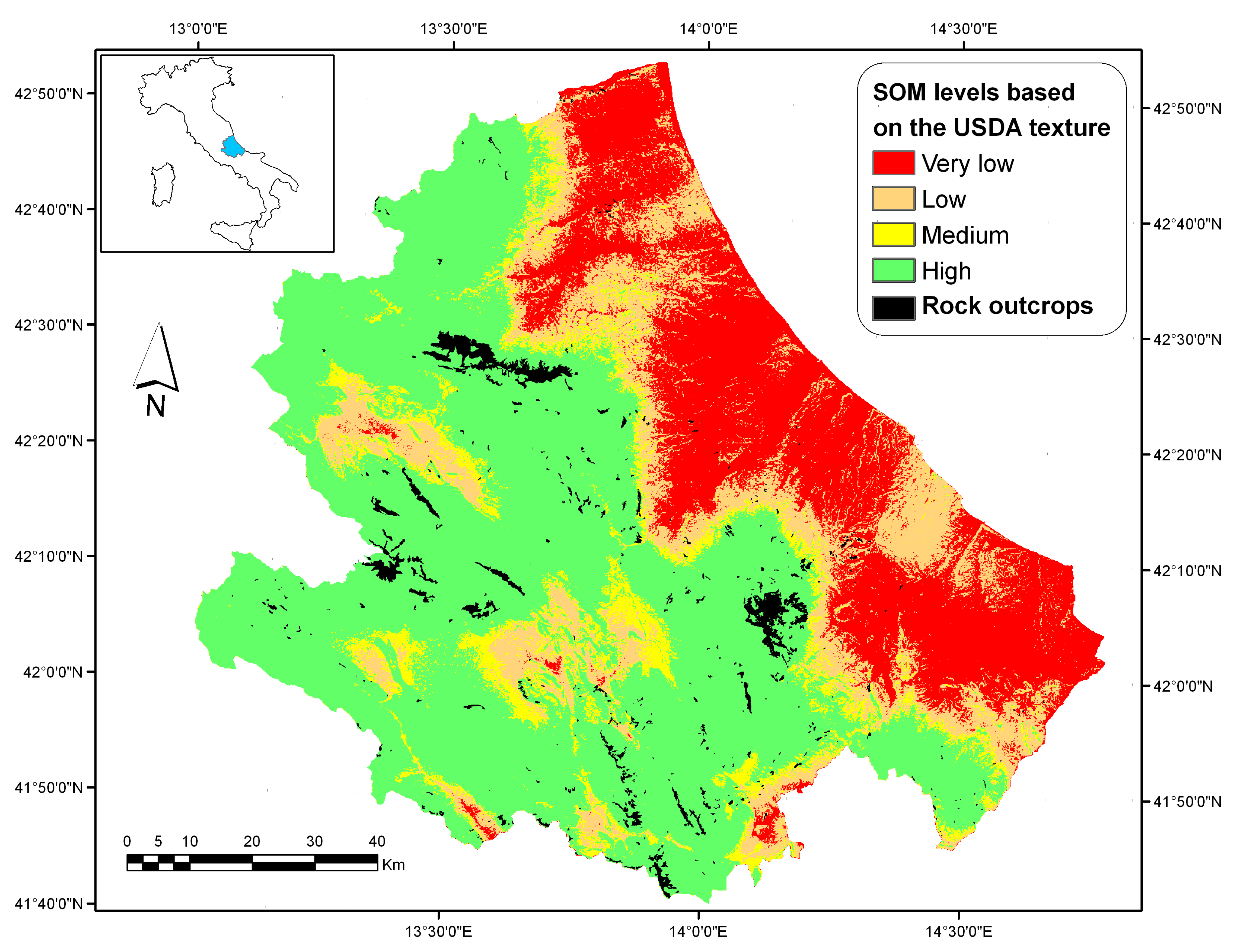
| USDA Texture Class | SOM Content | |||
|---|---|---|---|---|
| Very Low | Low | Medium | High | |
| % | ||||
| Sand, Loamy Sand, Sandy Loam | <0.8 | 0.8–1.4 | 1.5–2.0 | >2.0 |
| Loam, Sandy Clay, Sandy Clay Loam, Silty Loam, Silt | <1.0 | 1.0–1.8 | 1.9–2.5 | >2.5 |
| Clay, Clay Loam, Silty Clay, Silty Clay Loam | <1.2 | 1.2–2.2 | 2.3–3.0 | >3.0 |
| Elevation | Slope | Profc | Planc | Twi | Solar | Flowacc | SPI | CI | NDVI | SST86 | Sand | Clay | SOC | |
|---|---|---|---|---|---|---|---|---|---|---|---|---|---|---|
| PC1 | 0.277 | 0.236 | 0.334 | 0.334 | 0.256 | 0.419 | 0.026 | 0.055 | 0.358 | 0.404 | 0.330 | *** | *** | *** |
| PC2 | −0.344 | −0.514 | 0.108 | 0.146 | 0.522 | 0.417 | 0.103 | −0.051 | −0.257 | −0.238 | 0.036 | *** | *** | *** |
| PC3 | −0.371 | −0.104 | −0.022 | −0.010 | 0.148 | −0.040 | 0.042 | 0.026 | 0.433 | 0.443 | −0.664 | ** | *** | *** |
| PC4 | −0.065 | 0.223 | 0.424 | 0.422 | −0.398 | 0.258 | −0.183 | −0.224 | −0.228 | −0.206 | −0.429 | *** | ||
| PC5 | 0.474 | 0.305 | −0.184 | −0.099 | 0.370 | 0.193 | 0.157 | 0.366 | −0.228 | −0.174 | −0.474 | *** | ** | *** |
| PC6 | 0.326 | −0.331 | −0.175 | −0.441 | −0.293 | 0.570 | −0.168 | −0.295 | 0.098 | 0.117 | −0.097 | *** | *** | |
| PC7 | −0.574 | 0.525 | −0.154 | −0.326 | −0.084 | 0.422 | −0.065 | 0.212 | −0.011 | −0.052 | 0.166 | * | *** | |
| PC8 | 0.028 | 0.009 | −0.013 | −0.020 | 0.309 | −0.110 | −0.941 | 0.071 | −0.009 | −0.011 | −0.010 | * | * | |
| PC9 | 0.023 | 0.104 | 0.711 | −0.612 | 0.204 | −0.162 | 0.079 | −0.174 | −0.055 | −0.021 | −0.039 | * | ||
| PC10 | −0.013 | 0.361 | −0.320 | 0.056 | 0.336 | −0.056 | 0.063 | −0.801 | −0.045 | 0.013 | −0.009 | *** | *** | |
| PC11 | 0.040 | 0.013 | 0.018 | 0.007 | 0.041 | 0.020 | 0.011 | −0.035 | 0.707 | −0.703 | −0.026 | |||
| R2 | 0.72 | 0.81 | 0.93 | |||||||||||
© 2020 by the authors. Licensee MDPI, Basel, Switzerland. This article is an open access article distributed under the terms and conditions of the Creative Commons Attribution (CC BY) license (http://creativecommons.org/licenses/by/4.0/).
Share and Cite
Piccini, C.; Francaviglia, R.; Marchetti, A. Predicted Maps for Soil Organic Matter Evaluation: The Case of Abruzzo Region (Italy). Land 2020, 9, 349. https://doi.org/10.3390/land9100349
Piccini C, Francaviglia R, Marchetti A. Predicted Maps for Soil Organic Matter Evaluation: The Case of Abruzzo Region (Italy). Land. 2020; 9(10):349. https://doi.org/10.3390/land9100349
Chicago/Turabian StylePiccini, Chiara, Rosa Francaviglia, and Alessandro Marchetti. 2020. "Predicted Maps for Soil Organic Matter Evaluation: The Case of Abruzzo Region (Italy)" Land 9, no. 10: 349. https://doi.org/10.3390/land9100349
APA StylePiccini, C., Francaviglia, R., & Marchetti, A. (2020). Predicted Maps for Soil Organic Matter Evaluation: The Case of Abruzzo Region (Italy). Land, 9(10), 349. https://doi.org/10.3390/land9100349


