Geospatial Data Approach for Demand-Oriented Policies of Land Administration

Abstract
1. Introduction
2. Materials and Methods
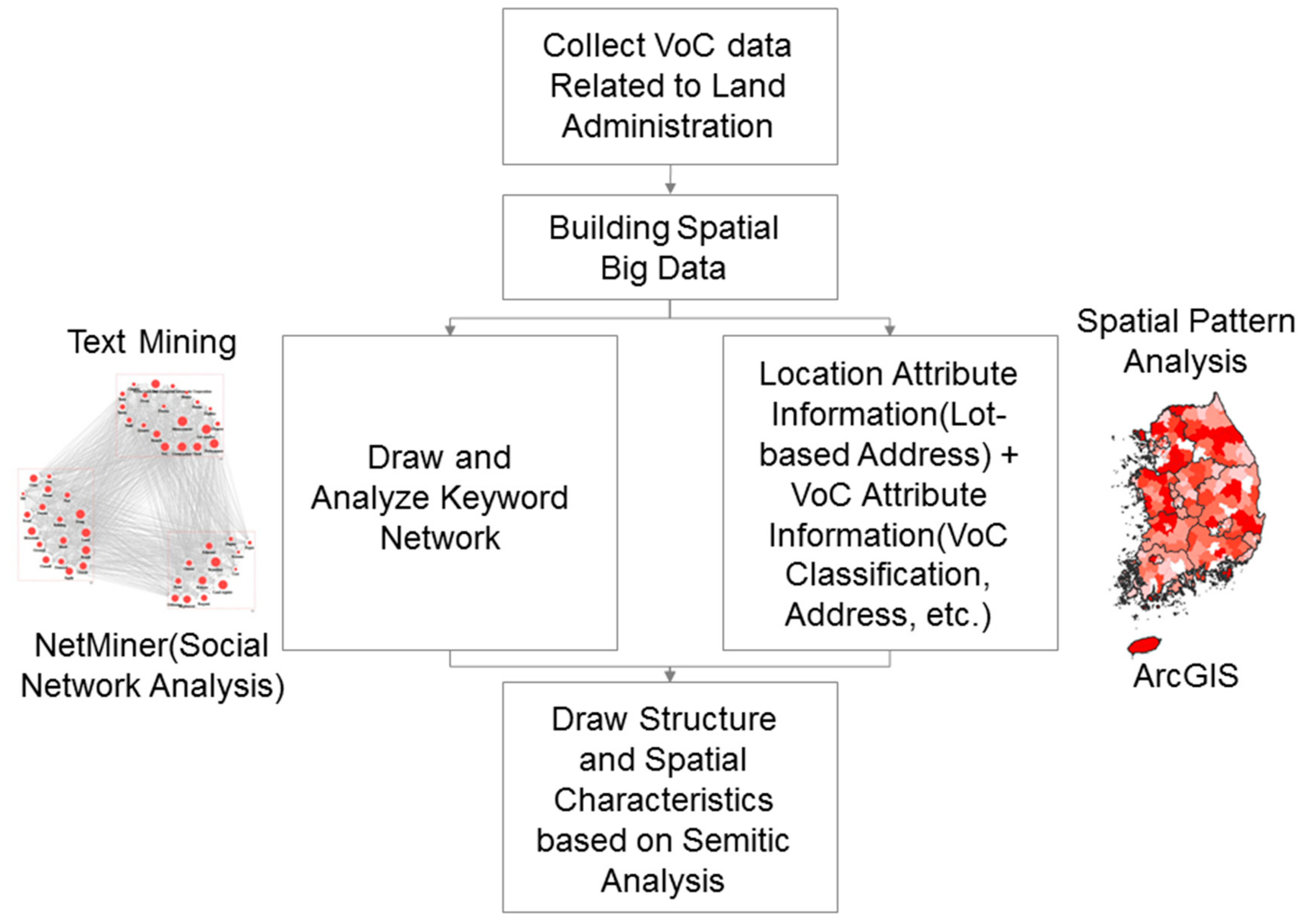
- Voice of Citizens data relating to a cadastral survey was collected for land administration data;
- Text mining, social network analysis, and GIS analysis methods were selected for structural and spatial analysis of the Voice of Citizens data;
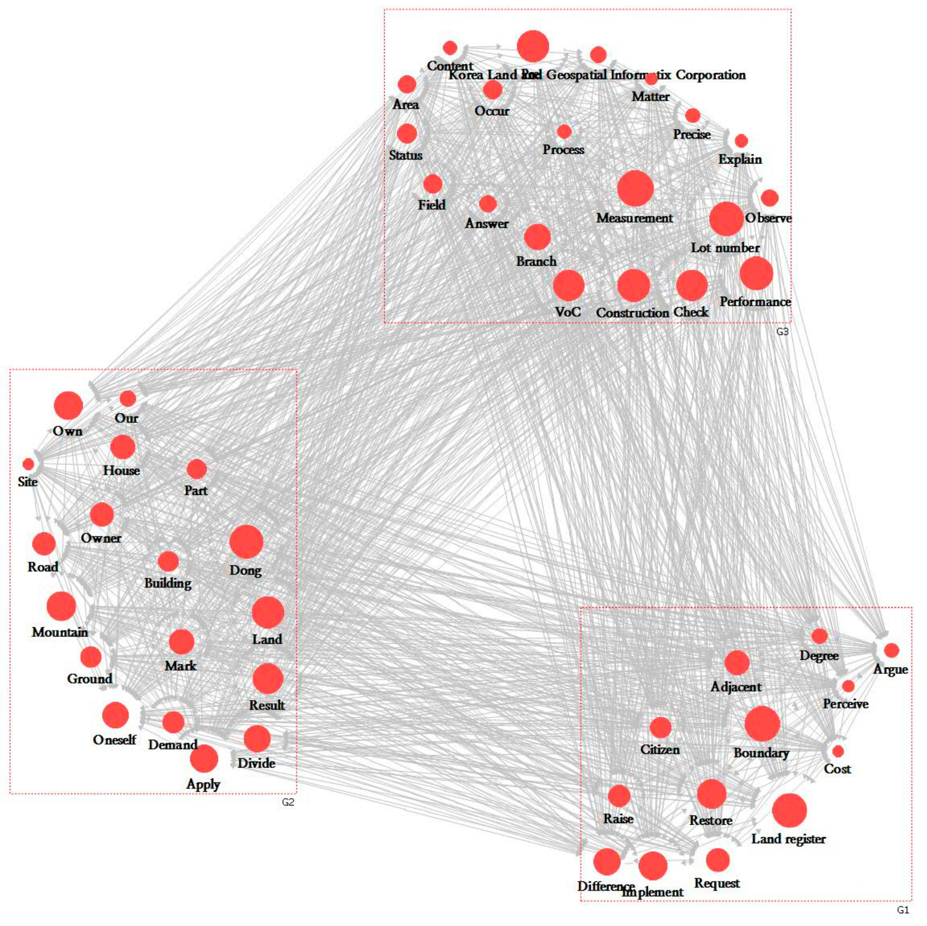
- Text mining was applied to five years of data (2011–2015). This process extracted keywords and placed them in a matrix. Then, cluster analysis was attempted using the Netminer program, a social network analysis tool;
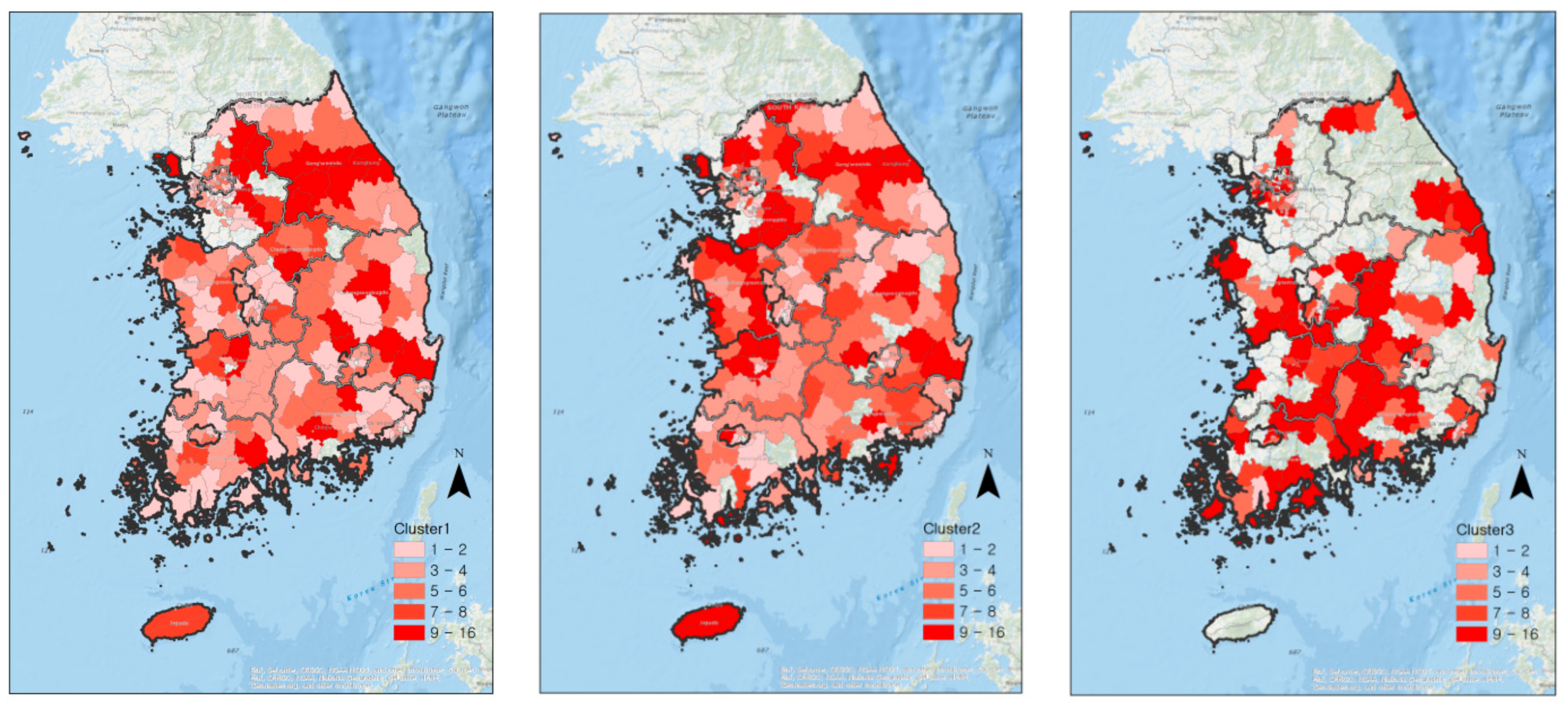
- The words grouped using cluster analysis were extracted again from the original text to reverse-track the location where the complaint was received. Then, using the geo-coding and mapping, the spatial significance was determined.
3. Results
Example 1
Example 2
Example 3
4. Discussion
5. Conclusions
Acknowledgments
Conflicts of Interest
References
- Saysel, A.K.; Barlas, Y.; Yenigün, O. Environmental sustainability in an agricultural development project: A system dynamics approach. J. Environ. Manag. 2002, 64, 247–260. [Google Scholar] [CrossRef] [PubMed]
- Jia, B.; Zhang, Z.; Ci, L.; Ren, Y.; Pan, B.; Zhang, Z. Oasis land-use dynamics and its influence on the oasis environment in Xinjiang, China. J. Arid. Environ. 2004, 56, 11–26. [Google Scholar] [CrossRef]
- Kombe, W.J. Land use dynamics in peri-urban areas and their implications on the urban growth and form: The case of Dar es Salaam, Tanzania. Habitat Int. 2005, 29, 113–135. [Google Scholar] [CrossRef]
- Gould, K.A.; Carter, D.R.; Shrestha, R.K. Extra-legal land market dynamics on a Guatemalan agricultural frontier: Implications for neoliberal land policies. Land Use Policy 2006, 23, 408–420. [Google Scholar] [CrossRef]
- Haregeweyn, N.; Fikadu, G.; Tsunekawa, A.; Tsubo, M.; Meshesha, D.T. The dynamics of urban expansion and its impacts on land use/land cover change and small-scale farmers living near the urban fringe: A case study of Bahir Dar, Ethiopia. Landsc. Urban Plan. 2012, 106, 149–157. [Google Scholar] [CrossRef]
- He, L.Y.; Liu, Q.; Chen, C.; Bian, A.H. Thermotolerance related to antioxidation induced by salicylic acid and heat acclimation in tall fescue seedlings. J. Plant Physiol. Mol. Biol. 2002, 28, 89–95. [Google Scholar]
- Cheng, J.; Masser, I. Urban growth pattern modeling: A case study of Wuhan city, PR China. Landsc. Urban Plan. 2003, 62, 199–217. [Google Scholar] [CrossRef]
- Maktav, D.; Erbek, F.S. Analysis of urban growth using multi-temporal satellite data in Istanbul, Turkey. Int. J. Remote Sens. 2005, 26, 797–810. [Google Scholar] [CrossRef]
- Hu, Z.; Lo, C. Modeling urban growth in Atlanta using logistic regression. Comput. Environ. Urban Syst. 2007, 31, 667–688. [Google Scholar] [CrossRef]
- Poelmans, L.; Van Rompaey, A. Detecting and modelling spatial patterns of urban sprawl in highly fragmented areas: A case study in the Flanders–Brussels region. Landsc. Urban Plan. 2009, 93, 10–19. [Google Scholar] [CrossRef]
- Luo, J.; Wei, Y.D. Modeling spatial variations of urban growth patterns in Chinese cities: The case of Nanjing. Landsc. Urban Plan. 2009, 91, 51–64. [Google Scholar] [CrossRef]
- Dashora, A.; Lohani, B.; Malik, J.N. A repository of earth resource information-CORONA satellite programme. Curr. Sci. 2007, 92, 926–932. [Google Scholar]
- Dewan, A.M.; Yamaguchi, Y. Land use and land cover change in Greater Dhaka, Bangladesh: Using remote sensing to promote sustainable urbanization. Appl. Geogr. 2009, 29, 390–401. [Google Scholar] [CrossRef]
- Gomez, B.T.; Wilson, J.M. Cognitive Heterogeneity and Economic Voting: A Comparative Analysis of Four Democratic Electorates. Am. J. Political Sci. 2006, 50, 127–145. [Google Scholar] [CrossRef]
- Margalit, Y. Explaining Social Policy Preferences: Evidence from the Great Recession. Am. Political Sci. Rev. 2013, 107, 80–103. [Google Scholar] [CrossRef]
- Sundberg, T.; Taylor-Gooby, P. A systematic review of comparative studies of attitudes to social policy. Soc. Policy Adm. 2013, 47, 416–433. [Google Scholar] [CrossRef]
- Tausanovitch, C.; Warshaw, C. Measuring Constituent Policy Preferences in Congress, State Legislatures, and Cities. J. Politics 2013, 75, 330–342. [Google Scholar] [CrossRef]
- Peters, Y.; Ensink, S.J. Differential responsiveness in Europe: The effects of preference difference and electoral participation. West Eur. Politics 2015, 38, 577–600. [Google Scholar] [CrossRef]
- Stubager, R. Inequality in the ‘Conflict of Conflicts’? The impact of citizen sophistication on agenda-setting effects. Politics Stud. 2015, 63, 793–813. [Google Scholar] [CrossRef]
- Bullock, H.E. Social class and policy preferences: Implications for economic inequality and interclass relations. Curr. Opin. Psychol. 2017, 18, 141–146. [Google Scholar] [CrossRef]
- Kölln, A.-K. Political sophistication affects how citizens’ social policy preferences respond to the economy. West Eur. Politics 2018, 41, 196–217. [Google Scholar] [CrossRef]
- Williamson, I. Land administration “best practice” providing the infrastructure for land policy implementation. Land Use Policy 2010, 18, 297–307. [Google Scholar] [CrossRef]
- Williamson, I.; Enemark, S.; Wallace, J.; Rajabifard, A. Land Administration for Sustainable Development. In Proceedings of the FIG Congress 2010, Sydney, Australia, 11–16 April 2010. [Google Scholar]
- Lemmen, C.; Van Oosterom, P.; Bennett, R. The Land Administration Domain Model. Land Use Policy 2015, 49, 535–545. [Google Scholar] [CrossRef]
- Carter, L.; Bélanger, F. The utilization of e-government services: Citizen trust, innovation and acceptance factors. Inf. Syst. J. 2005, 15, 5–25. [Google Scholar] [CrossRef]
- Dombrowski, L.; Hayes, G.R.; Mazmanian, M.; Voida, A. E-government intermediaries and the challenges of access and trust. ACM Trans. Comput. Interact. 2014, 21, 1–22. [Google Scholar] [CrossRef]
- King, S.; Cotterill, S. Transformational Government? The role of information technology in delivering citizen-centric local public services. Local Gov. Stud. 2007, 33, 333–354. [Google Scholar] [CrossRef]
- West, D.M. E-Government and the Transformation of Service Delivery and Citizen Attitudes. Public Adm. Rev. 2004, 64, 15–27. [Google Scholar] [CrossRef]
- Seneviratne, S.J. Technology and organizational change in the public sector. In Information Technology and Computer Applications in Public Administration: Issues and Trends; Garson, G.D., Ed.; Idea Group Publishing: Hershey, PA, USA, 1999; pp. 41–61. [Google Scholar]
- ArrayExpress—A Database of Functional Genomics Experiments. Available online: http://www.ebi.ac.uk/arrayexpress/ (accessed on 12 November 2012).
- Snead, J.T.; Wright, E. E-government research in the United States. Gov. Inf. Q. 2014, 31, 129–136. [Google Scholar] [CrossRef]
- Jun, C.N.; Chung, J.C. Big data analysis of local government 3.0: Focusing on Gyeongsangbuk-do in Korea. Technol. Forecast. Soc. Chang. 2014, 110, 3–12. [Google Scholar] [CrossRef]
- Park, S. Opening Big Data Analysis and Application Centers; ZDNet: Seoul, Korea, 2013. Available online: http://www.zdnet.co.kr/news/news_view.asp?artice_id=20131024134751 (accessed on 4 December 2017).
- Nam, T. Government 3.0 in Korea Fad or Fashion; Association for Computing Machinery: New York, NY, USA, 2013; pp. 46–55. [Google Scholar]
- Kassen, M. A promising phenomenon of open data: A case study of the Chicago open data project. Gov. Inf. Q. 2013, 30, 508–513. [Google Scholar] [CrossRef]
- Ubaldi, B. Open Government Data: Towards Empirical Analysis of Open Government Data Initiatives. OECD Work. Pap. Public Gov. 2013. [Google Scholar] [CrossRef]
- Veljković, N.; Bogdanovic-Dinic, S.; Stoimenov, L. Benchmarking open government: An open data perspective. Gov. Inf. Q. 2014, 31, 278–290. [Google Scholar] [CrossRef]
- Zuiderwijk, A.; Janssen, M. Open data policies, their implementation and impact: A framework for comparison. Gov. Inf. Q. 2016, 31, 17–29. [Google Scholar] [CrossRef]
- Sieber, R.E.; Johnson, P.A. Civic open data at a crossroads: Dominant models and current challenges. Gov. Inf. Q. 2016, 32, 308–315. [Google Scholar] [CrossRef]
- Vos, J.; Huitema, G.; De Lange-Ros, E. How organisations can learn from complaints. TQM J. 2008, 20, 8–17. [Google Scholar] [CrossRef]
- Zairi, M. Managing customer dissatisfaction through effective complaints management systems. TQM Mag. 2000, 12, 331–337. [Google Scholar] [CrossRef]
- Stauss, B. The dimensions of complaint satisfaction: Process and outcome complaint satisfaction versus cold fact and warm act complaint satisfaction. Manag. Serv. Qual. Int. J. 2002, 12, 173–183. [Google Scholar] [CrossRef]
- Orsingher, C.; Valentini, S.; de Angelis, M. A meta-analysis of satisfaction with complaint handling in services. J. Acad. Mark. Sci. 2010, 38, 169–186. [Google Scholar] [CrossRef]
- Ferguson, J.L.; Johnston, W.J. Customer response to dissatisfaction: A synthesis of literature and conceptual framework. Ind. Mark. Manag. 2011, 40, 118–127. [Google Scholar] [CrossRef]
- McQuilken, L.; Robertson, N. The influence of guarantees, active requests to voice and failure severity on customer complaint behavior. Int. J. Hosp. Manag. 2011, 30, 953–962. [Google Scholar] [CrossRef]
- Hsieh, S.Y. Using complaints to enhance quality improvement: Developing an analytical tool. Int. J. Heal. Care Qual. Assur. 2012, 25, 453–461. [Google Scholar] [CrossRef]
- Bosch, V.G.; Enríquez, F.T. TQM and QFD: Exploiting a customer complaint management system. Int. J. Qual. Reliab. Manag. 2005, 22, 30–37. [Google Scholar] [CrossRef]
- Galitsky, B.A.; González, M.P.; Chesñevar, C.I. A novel approach for classifying customer complaints through graphs similarities in argumentative dialogues. Decis. Support Syst. 2009, 46, 717–729. [Google Scholar] [CrossRef]
- Debii, C. Handling e-complaints in customer complaint management system using FMEA as a qualitative system. In Proceedings of the 2010 6th International Conference on Advanced Information Management and Service (IMS), Seoul, Korea, 30 November–2 December 2010; pp. 205–209. [Google Scholar]
- Pyon, C.U.; Woo, J.Y.; Park, S.C. Service improvement by business process management using customer complaints in financial service industry. Expert Syst. Appl. 2011, 38, 3267–3279. [Google Scholar] [CrossRef]
- Shi, W.-H.; Liu, J.-Y.; Zhang, Y. The effect of service failure attribution on consumer complaint behavior: The mediating role of negative emotion. J. China Univ. Posts Telecommun. 2011, 18, 169–173. [Google Scholar] [CrossRef]
- Stone, M. Literature review on complaints management. J. Database Mark. Cust. Strat. Manag. 2011, 18, 108–122. [Google Scholar] [CrossRef]
- Aguwa, C.C.; Monplaisir, L.; Turgut, O. Voice of the customer: Customer satisfaction ratio based analysis. Expert Syst. Appl. 2012, 39, 10112–10119. [Google Scholar] [CrossRef]
- Atlikhan, A.; Albadvi, A.; Ghapanchi, A.H. A conceptual model for proactive-interactive customer complaint management systems. Int. J. Bus. Inf. Syst. 2013, 13, 490. [Google Scholar] [CrossRef]
- Sharma, S.; Goyal, D.; Mittal, R. Data mining research for customer relationship management systems: A framework and analysis. Int. J. Bus. Inf. Syst. 2008, 3, 549–565. [Google Scholar] [CrossRef]
- Chen, C.-K.; Shie, A.-J.; Yu, C.-H. A customer-oriented organisational diagnostic model based on data mining of customer-complaint databases. Expert Syst. Appl. 2012, 39, 786–792. [Google Scholar] [CrossRef]
- Chen, J.; Gong, P.; He, C.; Luo, W.; Tamura, M.; Shi, P. Assessment of the urban development plan of Beijing by using a CA-based urban growth model. Photogramm. Eng. Remote Sens. 2002, 68, 1063–1071. [Google Scholar]
- Brennan, C.; Douglas, A. Complaints procedures in local government: Informing your customers. Int. J. Public Sector Manag. 2002, 15, 219–236. [Google Scholar] [CrossRef]
- Coussement, K.; Poel, D.V.D. Improving customer complaint management by automatic email classification using linguistic style features as predictors. Decis. Support Syst. 2008, 44, 870–882. [Google Scholar] [CrossRef]
- Sitko-Lutek, A.; Chuancharoen, S.; Sukpitikul, A.; Phusavat, K. Applying social network analysis on customer complaint handling. Ind. Manag. Data Syst. 2010, 110, 1402–1419. [Google Scholar] [CrossRef]
- Steinhäußer, R.; Siebert, R.; Steinführer, A.; Hellmich, M. National and regional land-use conflicts in Germany from the perspective of stakeholders. Land Use Policy 2015, 49, 183–194. [Google Scholar] [CrossRef]
- Roehl, W.S.; Fesenmaier, D.R. Tourism land use conflict in the United States. Ann. Tour. Res. 1987, 14, 471–485. [Google Scholar] [CrossRef]
- Mann, C.; Jeanneaux, P. Two approaches for understanding land-use conflict to improve rural planning and management. J. Rural. Commun. Dev. 2009, 4, 118–141. [Google Scholar]
- Von Der Dunk, A.; Grêt-Regamey, A.; Dalang, T.; Hersperger, A.M. Defining a typology of peri-urban land-use conflicts—A case study from Switzerland. Landsc. Urban Plan. 2011, 101, 149–156. [Google Scholar] [CrossRef]
- Milczarek-Andrzejewska, D.; Zawalińska, K.; Czarnecki, A. Land-use conflicts and the Common Agricultural Policy: Evidence from Poland. Land Use Policy 2018, 73, 423–433. [Google Scholar] [CrossRef]
- Jakob, E. Demand-Oriented Innovation Policy; Office of Technology Assessmentat the German Bundestag: Berlin, Germany, 2009; Available online: https://www.tab-beim-bundestag.de/en/pdf/publications/summarys/TAB-Arbeitsbericht-ab099_Z.pdf (accessed on 1 December 2019).
- Dawkins, C.E. The principle of good faith: Toward substantive stakeholder engagement. J. Bus. Ethics 2014, 121, 283–295. [Google Scholar] [CrossRef]
- Matten, D.; Crane, A. What is stakeholder democracy? Perspectives and issues. Bus. Ethics Eur. Rev. 2005, 14, 6–13. [Google Scholar] [CrossRef]
- Moriarty, J. The connection between stakeholder theory and stakeholder democracy: An excavation and defense. Bus. Soc. 2014, 53, 820–852. [Google Scholar] [CrossRef]
- O’Dwyer, B. Stakeholder democracy: Challenges and contributions from social accounting. Bus. Ethics Eur. Rev. 2005, 14, 28–41. [Google Scholar] [CrossRef]
- Turnbull, S. Stakeholder democracy: Redesigning the governance of firms and bureaucracies. J. Socio-Econ. 1994, 23, 321–360. [Google Scholar] [CrossRef]
- Harrison, J.S.; Freeman, R.E. Special topic: Democracy in and around organizations is organizational democracy worth the effort? Acad. Manag. Exec. 2004, 18, 49–53. [Google Scholar] [CrossRef]
- Kerr, J.L. The limits of organizational democracy. Acad. Manag. Exec. 2004, 18, 81–95. [Google Scholar] [CrossRef]
- Powley, E.H.; Fry, R.E.; Barrett, F.J.; Bright, D.S. Dialogic de-mocracy meets command and control: Transformation through the appreciative inquiry summit. Acad. Manag. Exec. 2004, 18, 67–80. [Google Scholar] [CrossRef]
- Kim, J.M.; Choi, Y.S.; Yoon, H.S.; Kim, Y.D. A Study on the Improvement of Efficient Execution System for Cadastral Resurvey Project. Korea Spat. Inf. Soc. 2013, 21, 47–62. [Google Scholar] [CrossRef][Green Version]
- Park, C.W. Symposium: The cadastral map re-examination and civil affair dispute about the Land boundary. Legal Res. 2010, 18, 21–62. [Google Scholar]
- Kim, N.S.; Lee, S.C.; Kim, H.T. Research on Development of Model for Korean-Style ADR System of Cadastre Field. J. Korean Assoc. Cadastre Inf. 2005, 7, 31–51. [Google Scholar]
- Kim, J.B. A Study on Cadastral Reform Project Issues and Solutions: Focus on Land Boundary Disputes and Settlement Procedures; The Graduate School of Industry, Kyungil University: Gamasil-gil, Korea, 2006. [Google Scholar]
- Kim, S.C. Current State and Challenges of Japan’s Accreditation System under the ADR Act. J. Korea Assoc. Arbitr. Stud. 2012, 22, 3–29. [Google Scholar]
- Kwon, I.H.; Choi, Y.S.; Jung, S.K.; Kim, J.M. A Study on the Solution of Cadastral Resurvey Project’s Conflict based on Conflict Model. In Proceedings of the Korean Association of Geographic Inforamtion Studies Conference; Korea Spatial Information Society: Seoul, Korea, 2010; pp. 25–37. [Google Scholar]
- Act on the Establishment, Management, etc of Spatial Data. Available online: https://elaw.klri.re.kr/kor_mobile/viewer.do?hseq=45348&type=part&key=35 (accessed on 2 January 2020).
- Kwon, Y.H. Perspective of Cadastral Resurvey Project Based on Conflict Model; The Graduate School of Urban Sciences, University of Seoul: Seoul, Korea, 2010. [Google Scholar]
- Kwon, Y.H. (A) Study of Priority Areas for Cadastral Resurvey; The Graduate School Information Science and Public Administration, Kangwon National University: Gangwon-do, Korea, 2011. [Google Scholar]
- Minister of Land, Infrastructure and Transport. A Study on the Improvement of Rational and Scientific Execution System for Cadastral Resurvey Project, Minister of Land, Infrastructure and Transport: Sejong-si, Korea, 2012.
- Song, H.J.; Kwon, D.J.; Kim, H.J. A Study on Landowners’ Understanding of Written Consent in the Housing Redevelopment Project District. J. Korean Soc. Cadastre Inf. 2011, 27, 15–32. [Google Scholar]
- Yoon, H.S.; Choi, Y.S.; Son, S.Y.; Kim, J.M. A Study on Present Conditions and Characteristics of Cadastral Surveying Accuracy in Korea. J. Korea Spat. Inf. Soc. 2011, 19, 27–35. [Google Scholar]


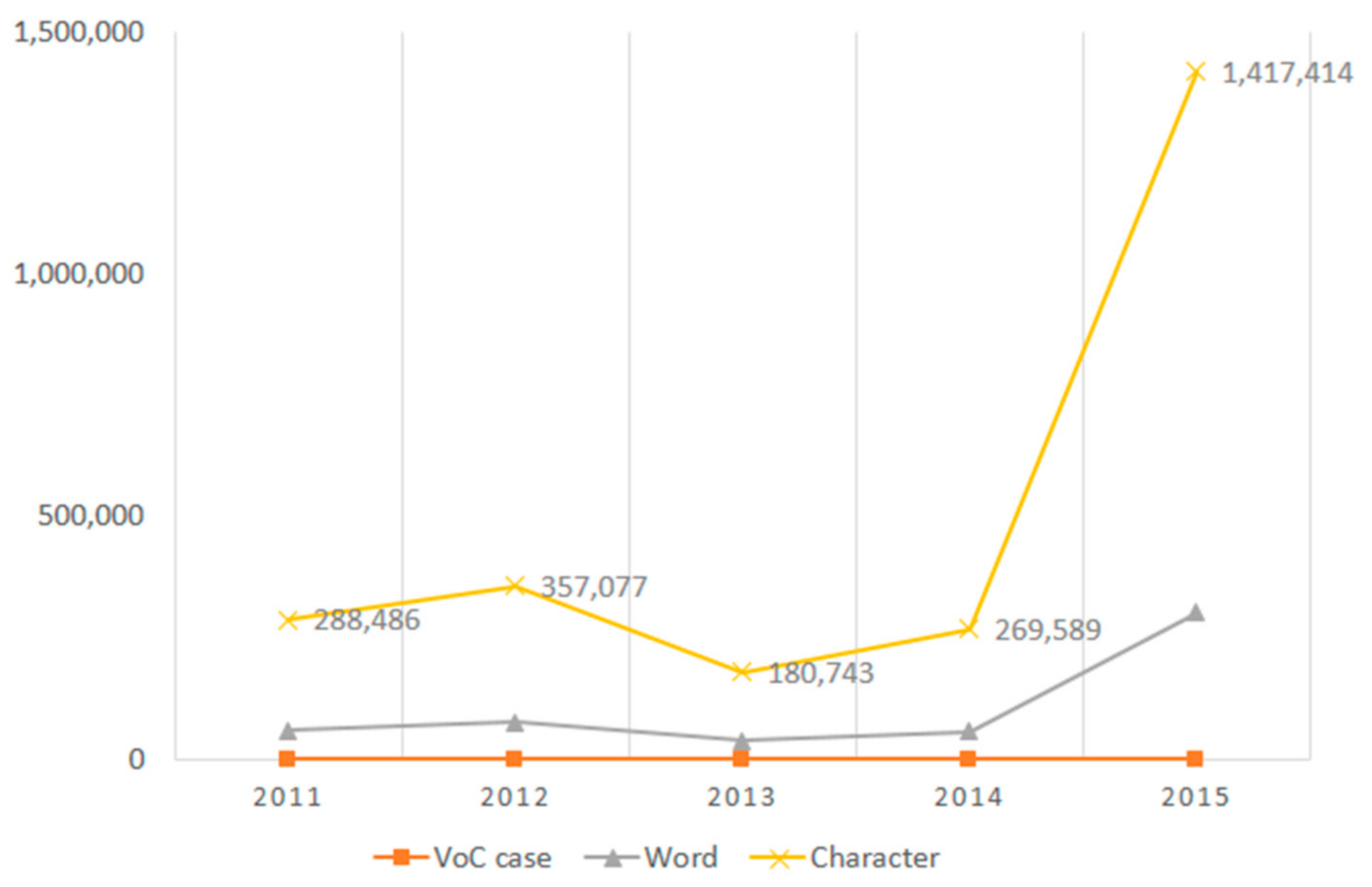
| Year | 2011 | 2012 | 2013 | 2014 | 2015 | Total |
|---|---|---|---|---|---|---|
| VoC * data | 1344 cases | 1700 cases | 922 cases | 1055 cases | 1143 cases | 6164 cases |
| Words | 60,758 | 77,705 | 38,915 | 56,751 | 302,549 | 536,678 |
| Characters | 288,486 | 357,077 | 180,743 | 269,589 | 1,417,414 | 2,513,309 |
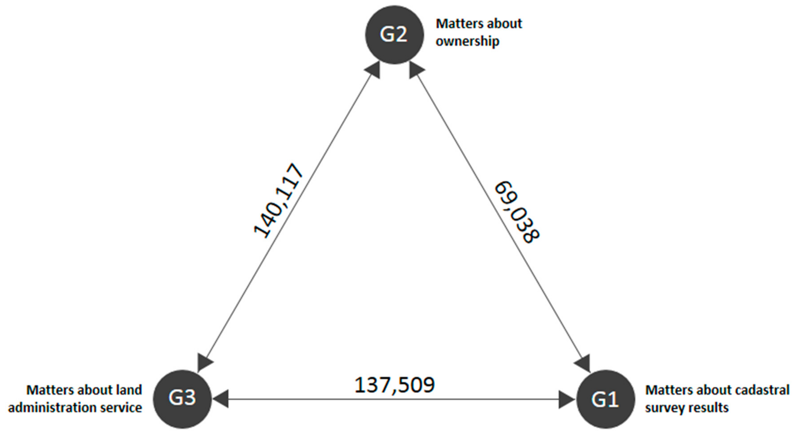
| G1 Matters about Cadastral Survey Results | G2 Matters about Ownership | G3 Matters about Land Administration Service | |||||||||
|---|---|---|---|---|---|---|---|---|---|---|---|
| Keyword | In-Degree Centrality | Out-Degree Centrality | Eigenvector Centrality | Keyword | In-Degree Centrality | Out-Degree Centrality | Eigenvector Centrality | Keyword | In-Degree Centrality | Out-Degree Centrality | Eigenvector Centrality |
| Boundary | 1682.9 | 1682.9 | 0.406992 | Land | 663.14 | 663.14 | 0.159423 | Measurement | 3173.12 | 3173.12 | 0.558833 |
| Cadastral | 930.2 | 930.2 | 0.223781 | Results | 528.42 | 528.42 | 0.14114 | Unit | 1187.38 | 1187.38 | 0.29259 |
| Recovery | 528.12 | 528.12 | 0.153287 | Divide | 321.16 | 321.16 | 0.087235 | Results | 803.24 | 803.24 | 0.217149 |
| Request | 274.18 | 274.18 | 0.069924 | Application | 333.92 | 333.92 | 0.090038 | Confirmation | 555.06 | 555.06 | 0.143902 |
| Execution | 368.54 | 368.54 | 0.102119 | Request | 245.68 | 245.68 | 0.063309 | Construction | 699.76 | 699.76 | 0.166664 |
| Difference | 332.28 | 332.28 | 0.091818 | Self | 295.7 | 295.7 | 0.074025 | Complaint | 631.36 | 631.36 | 0.138158 |
| Submission | 230.76 | 230.76 | 0.057426 | Indication | 290.26 | 290.26 | 0.077739 | Regional office | 303.92 | 303.92 | 0.074009 |
| Complain applicant | 229.62 | 229.62 | 0.05102 | Land | 229.94 | 229.94 | 0.055183 | Response | 163.56 | 163.56 | 0.03611 |
| Vicinity | 279.36 | 279.36 | 0.07201 | Mountain | 514 | 514 | 0.127038 | Site | 185.42 | 185.42 | 0.04711 |
| Assertion | 132.78 | 132.78 | 0.03241 | Building | 221.6 | 221.6 | 0.055175 | Status | 207.94 | 207.94 | 0.05514 |
| Level | 138.78 | 138.78 | 0.03477 | Roads | 247.5 | 247.5 | 0.05971 | Area | 175.12 | 175.12 | 0.04073 |
| Cognition | 106.2 | 106.2 | 0.02628 | Owner | 249.46 | 249.46 | 0.0587 | Content | 125.9 | 125.9 | 0.02859 |
| Cost | 70.14 | 70.14 | 0.020049 | Location | 30.64 | 30.64 | 0.006579 | Occurrence | 179.02 | 179.02 | 0.04547 |
| House | 276.38 | 276.38 | 0.06948 | Plot | 669.78 | 669.78 | 0.16217 | ||||
| Own | 478.66 | 478.66 | 0.11168 | Process | 127.28 | 127.28 | 0.026892 | ||||
| Our | 153.98 | 153.98 | 0.035844 | Cadastral agency | 160.42 | 160.42 | 0.03864 | ||||
| Part | 191.44 | 191.44 | 0.045184 | Item | 122.14 | 122.14 | 0.02719 | ||||
| Complex | 746.22 | 746.22 | 0.183904 | Accurate | 137.22 | 137.22 | 0.03571 | ||||
| Explanation | 124.4 | 124.4 | 0.02950 | ||||||||
| Observation | 172.64 | 172.64 | 0.04077 | ||||||||
© 2020 by the author. Licensee MDPI, Basel, Switzerland. This article is an open access article distributed under the terms and conditions of the Creative Commons Attribution (CC BY) license (http://creativecommons.org/licenses/by/4.0/).
Share and Cite
Choi, H. Geospatial Data Approach for Demand-Oriented Policies of Land Administration. Land 2020, 9, 31. https://doi.org/10.3390/land9010031
Choi H. Geospatial Data Approach for Demand-Oriented Policies of Land Administration. Land. 2020; 9(1):31. https://doi.org/10.3390/land9010031
Chicago/Turabian StyleChoi, HaeOk. 2020. "Geospatial Data Approach for Demand-Oriented Policies of Land Administration" Land 9, no. 1: 31. https://doi.org/10.3390/land9010031
APA StyleChoi, H. (2020). Geospatial Data Approach for Demand-Oriented Policies of Land Administration. Land, 9(1), 31. https://doi.org/10.3390/land9010031