Land Use Change in the Major Bays Along the Coast of the South China Sea in Southeast Asia from 1988 to 2018


Abstract
1. Introduction
2. Materials and Methods
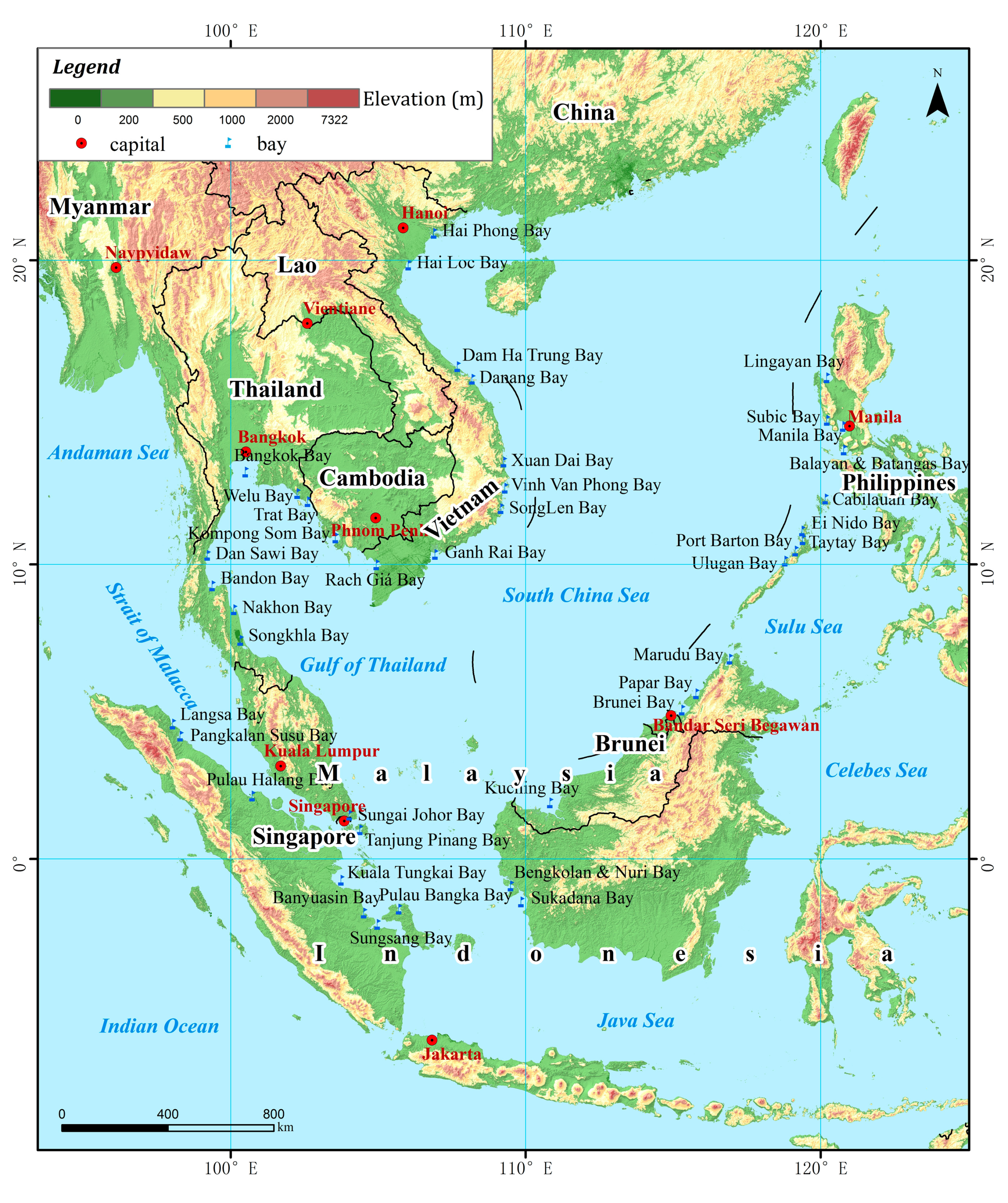
2.1. Study Area
2.2. Data Sources
2.3. Image Analysis
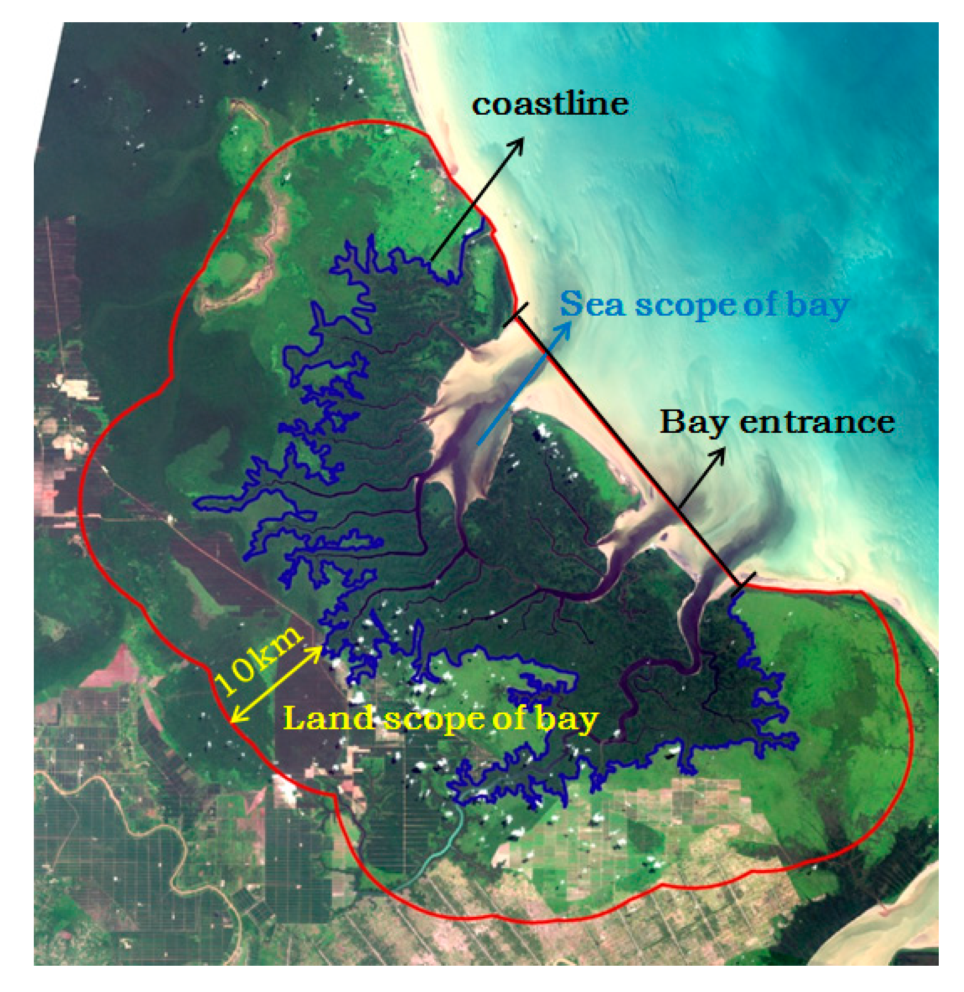
2.3.1. Bay Scope
- The bay area consisted of the land area and sea area.
- The land area was defined as landward area extending 10 km from the coastline.
- The sea area was defined as the waters enclosed by the coastline and the entrance of the bay.
- For the coasts with mangroves, the coastline lies on the landward vegetation line. This delineation can help with the analysis of the complete change in mangrove area in the bays.
2.3.2. Land Use Classification System
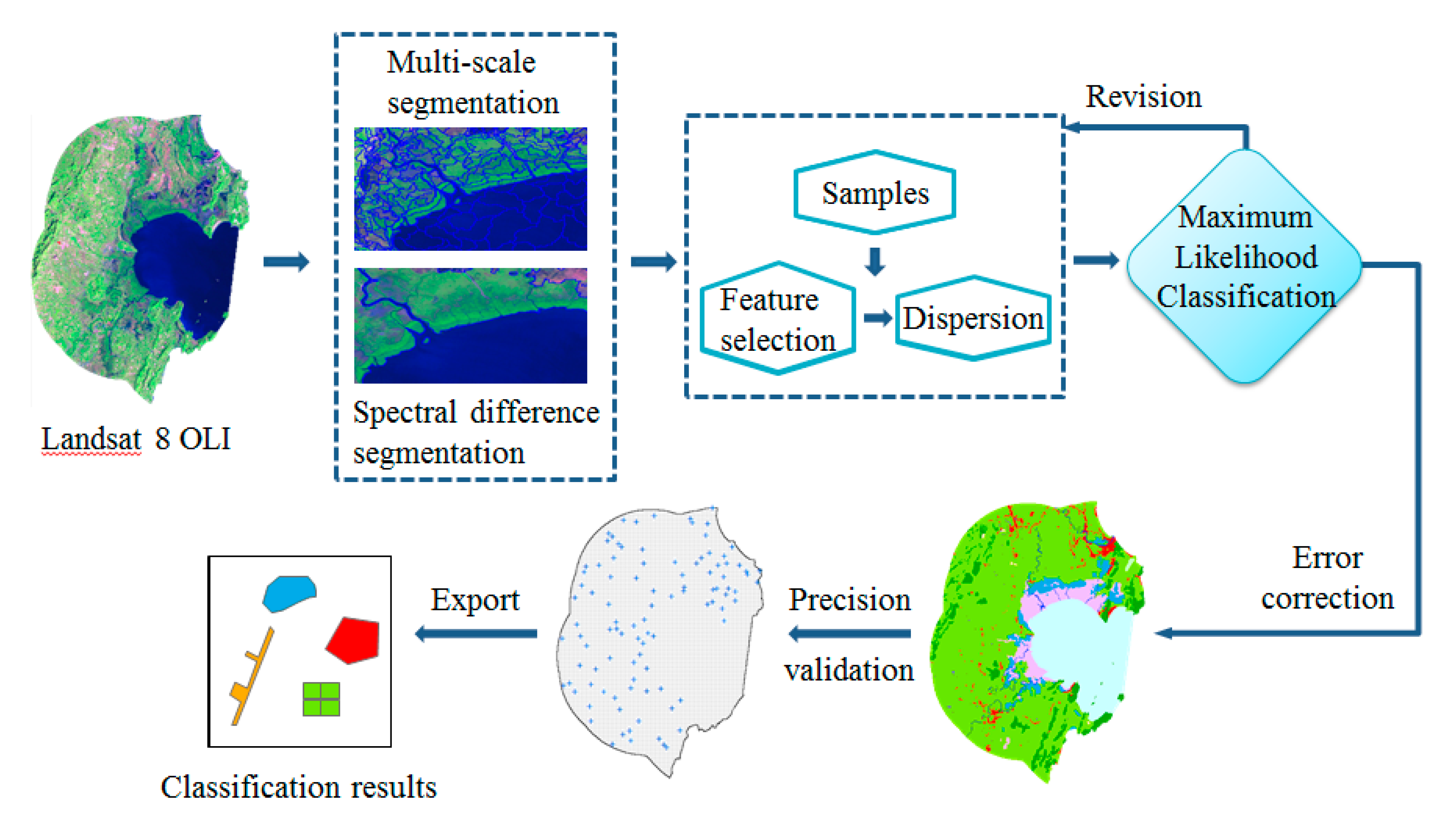
2.3.3. Image Classification Method
2.3.4. Data Analysis
- (1)
- Construction index (CI)
- CI = Area of construction land/Area of bay land
- We used the ratio of the construction land area and the total bay area to describe CI. CI indicates the regional economic development level. It is closely related to the population density and urban residential point density, etc.
- (2)
- Agricultural land index (NI)
- NI = Area of agricultural land/Area of bay land
- The agricultural land includes the culture ponds, cultivated land, and plantations. NI indicates the agricultural economic development level.
- (3)
- Forest index (FI)
- FI = Area of natural forest/Area of bay land
- The FI index indicates the percentage of natural forest cover.
- (4)
- Mangrove index (MI)
- MI = Area of mangrove/Area of bay land
- The MI index indicates the percentage of mangrove cover.
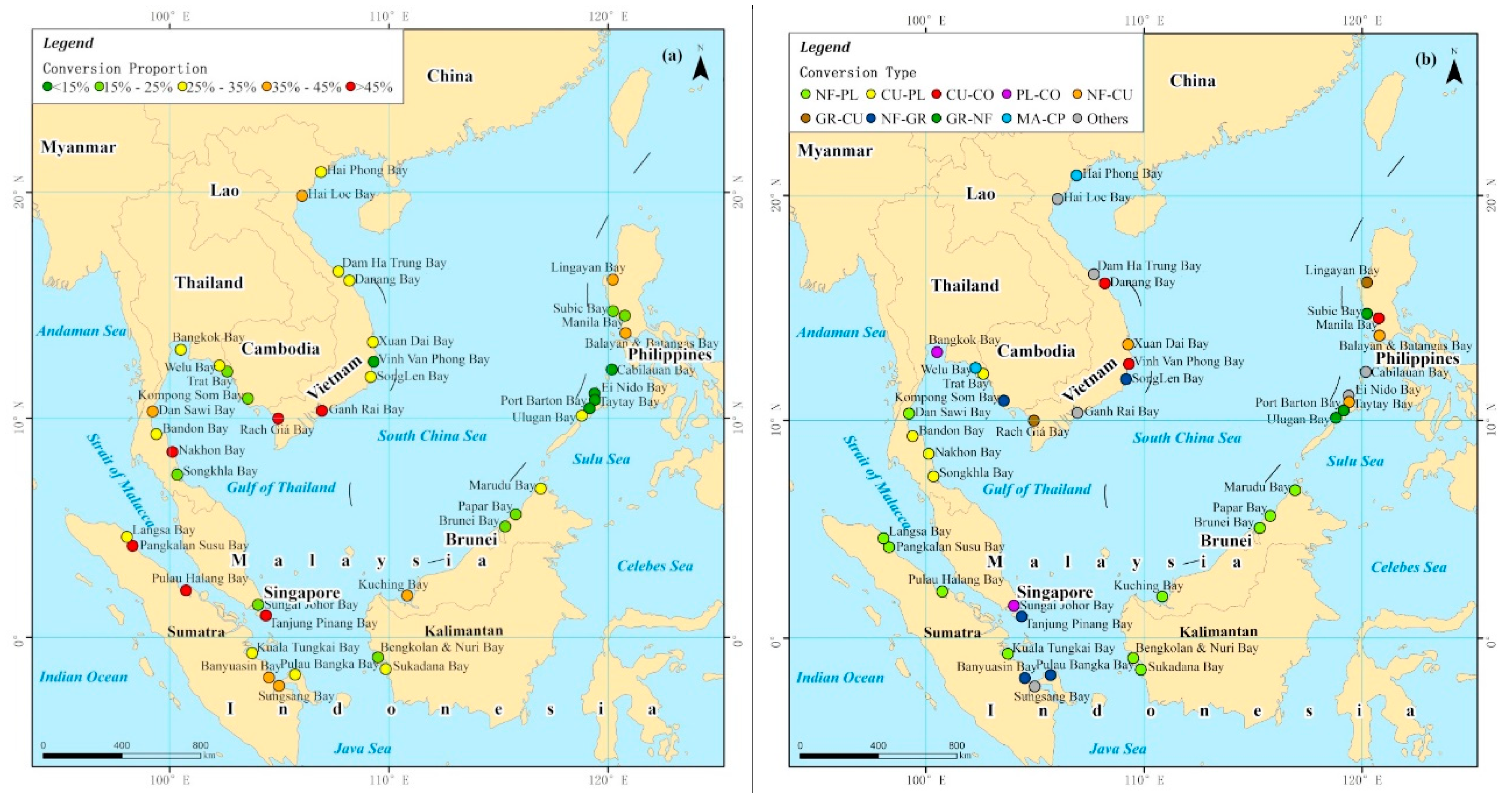
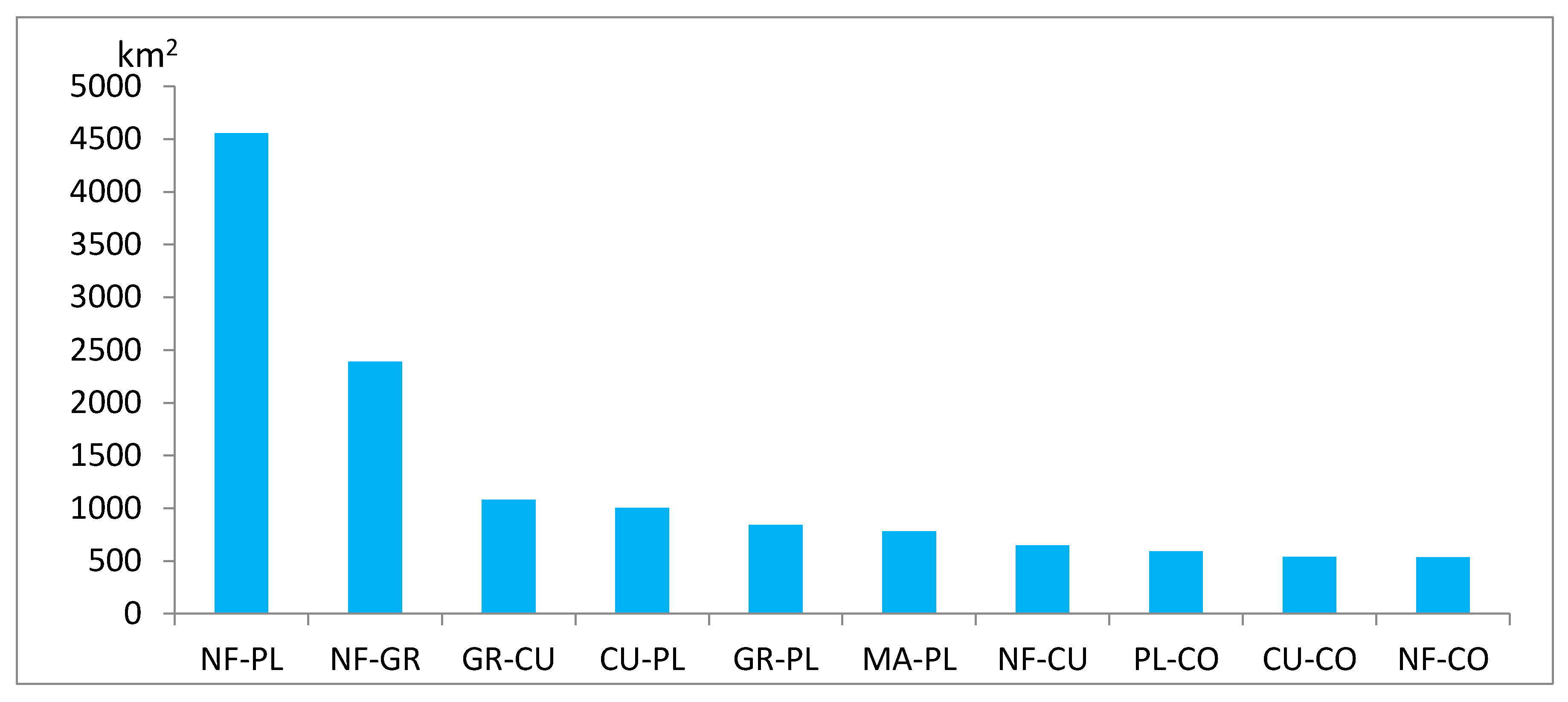
3. Results
3.1. Total Trends
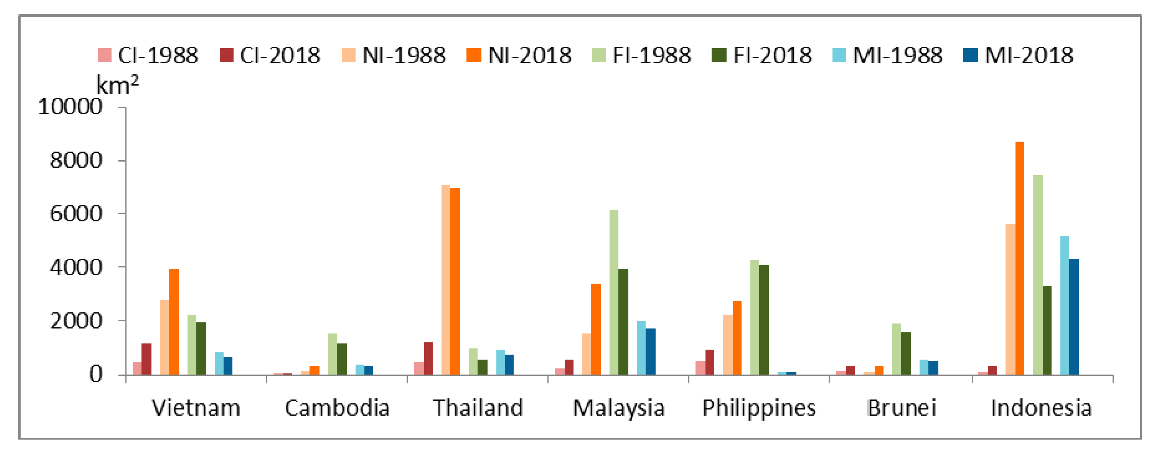
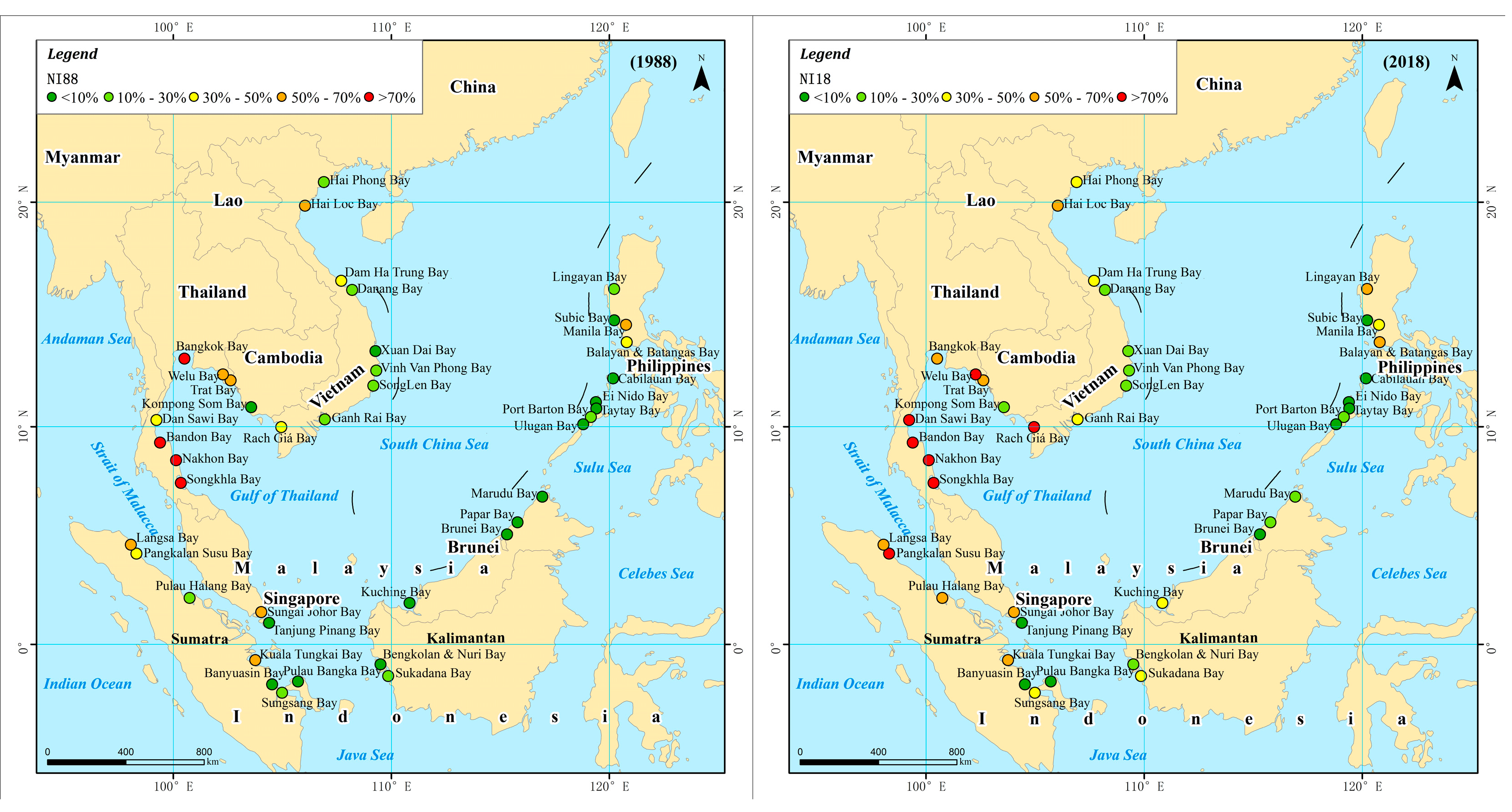
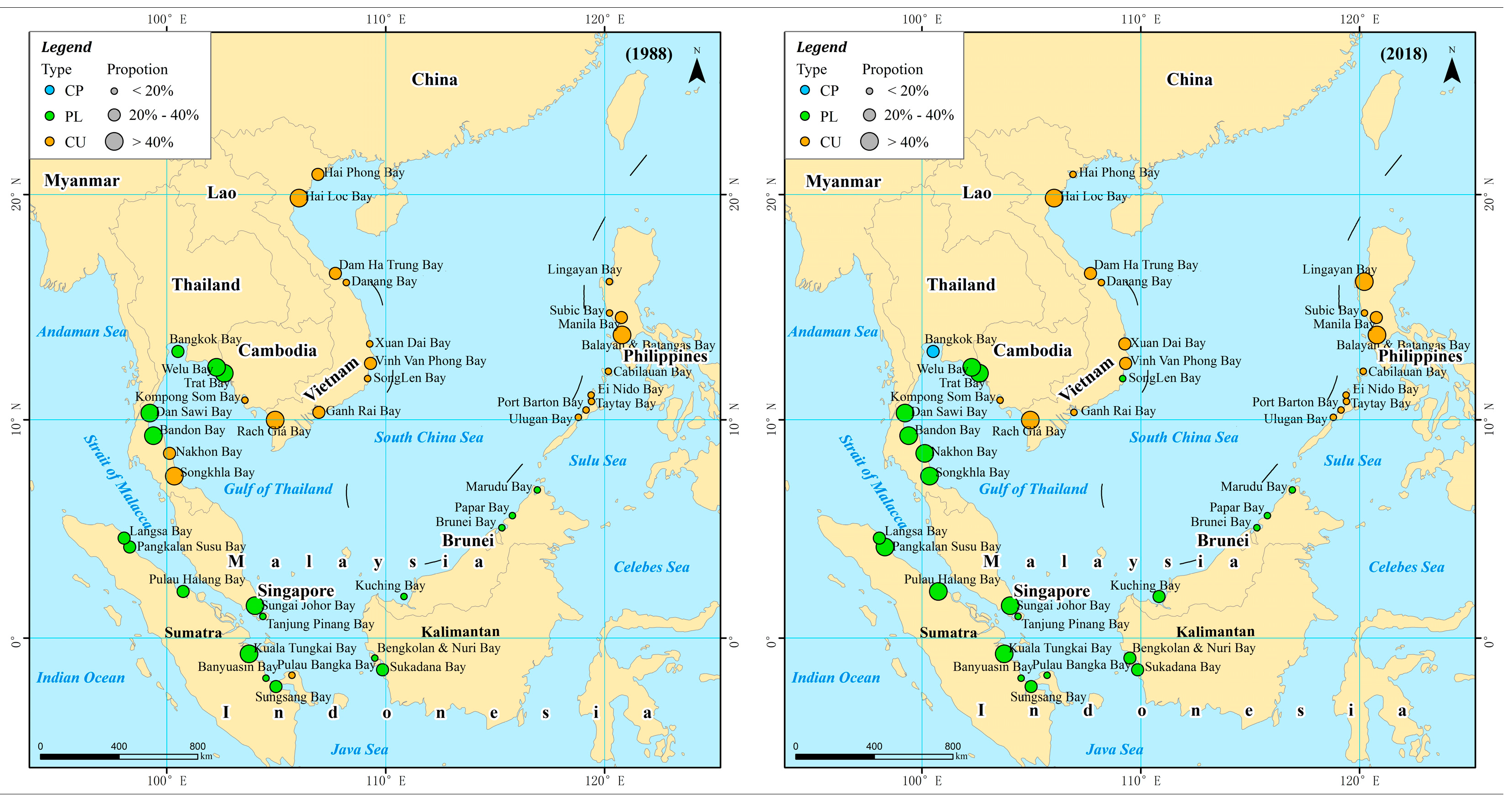
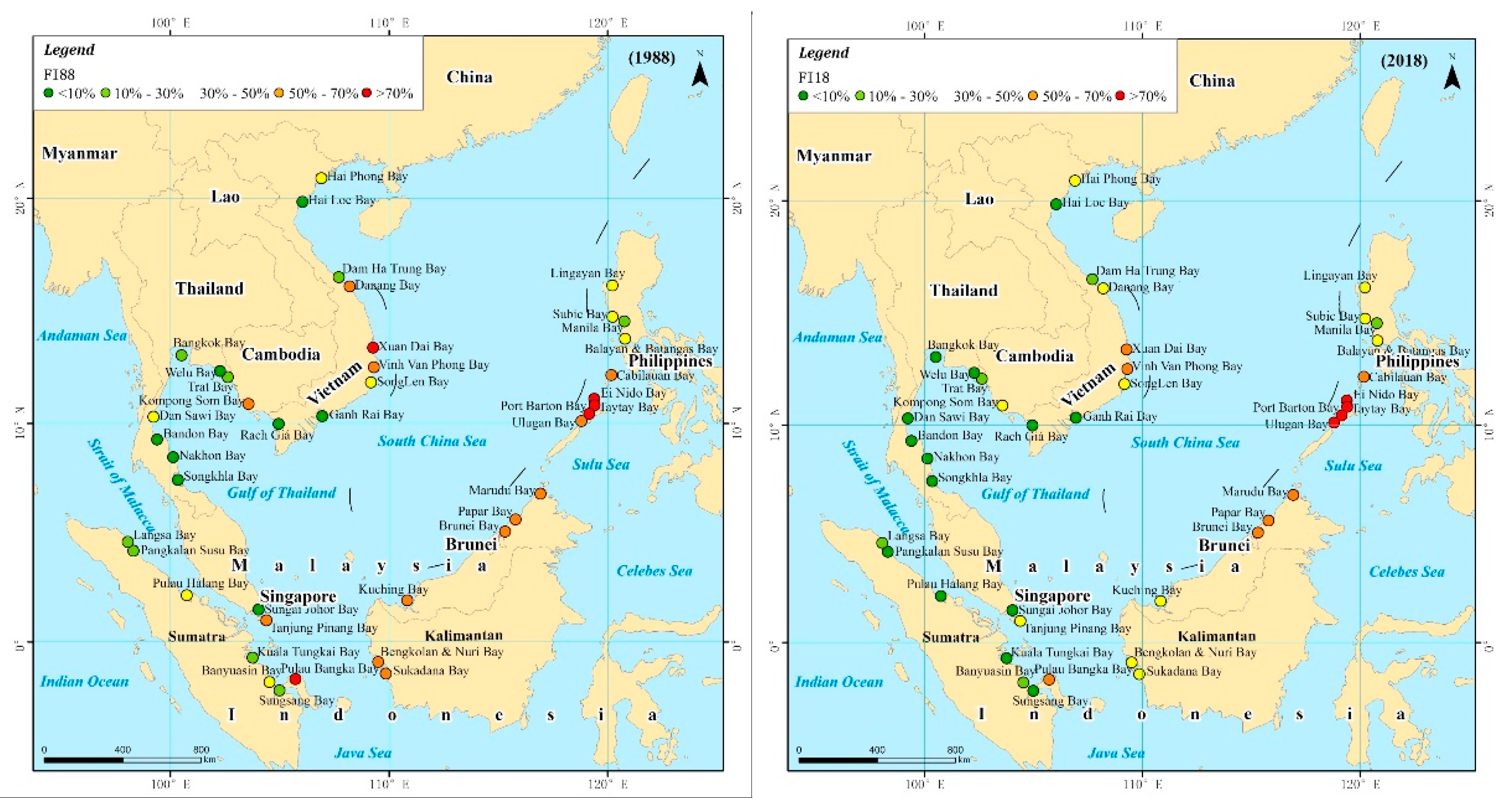
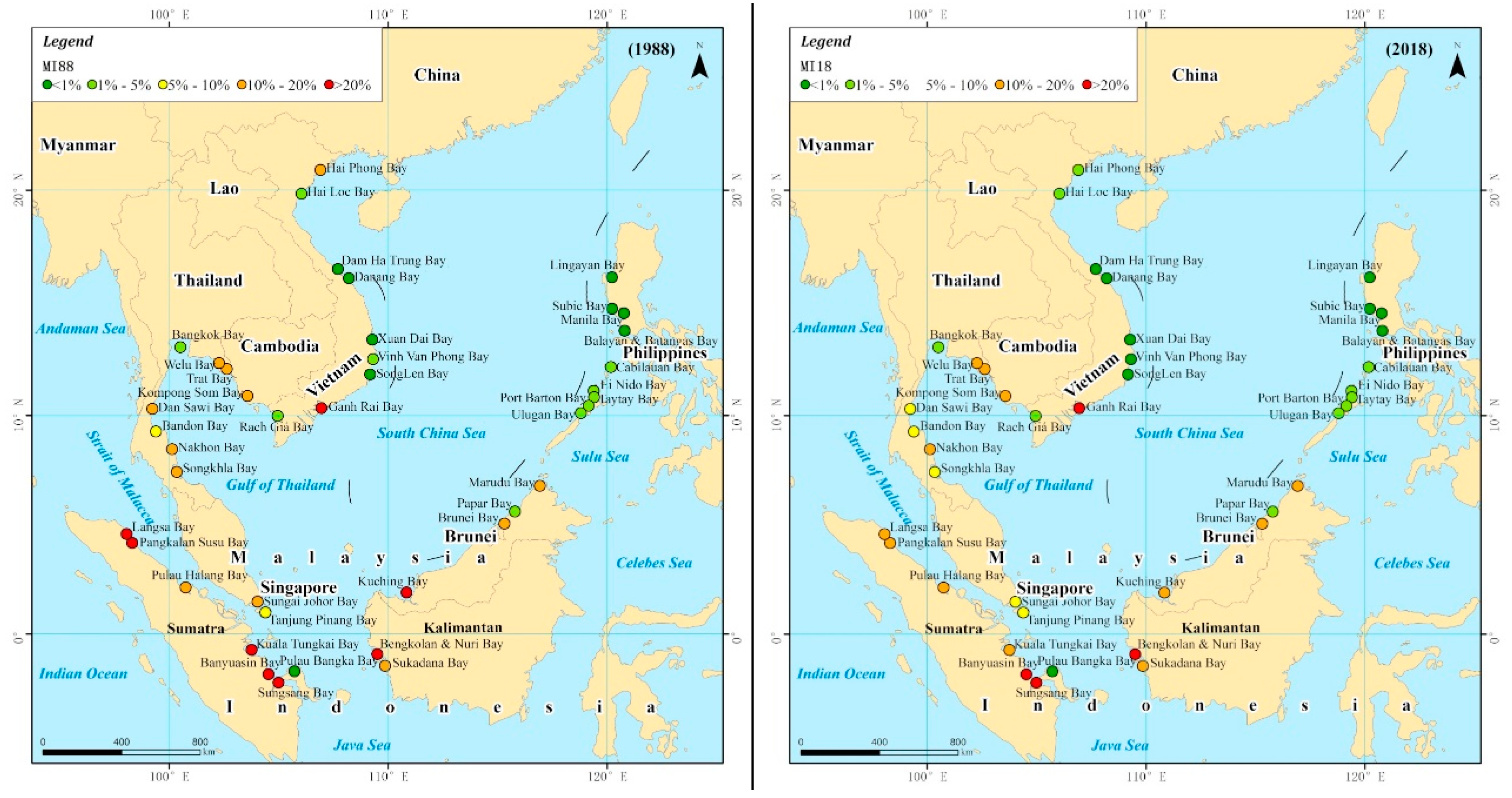
3.2. Country-Level Trends
3.3. Bay-Level Trends
4. Discussion
4.1. Expansion of Plantation
4.2. Deforestation
4.3. Mangrove Deforestation
5. Conclusions
Author Contributions
Funding
Conflicts of Interest
References
- Chen, Z.S.; Wang, W.H.; Wu, S.Y. An Introduction to Gulfs in China; Beijing China Ocean Press: Beijing, China, 2007. [Google Scholar]
- Zhang, D.D. Research on Exploitative Intensity Analysis and Evaluation Approach of Bay. Ph.D. Thesis, University of Chinese Academy of Sciences, Beijing, China, 2009. [Google Scholar]
- Huff, G.; Angeles, L. Globalization, industrialization and urbanization in Pre-World War II Southeast Asia. Explor. Econom. Hist. 2011, 48, 20–36. [Google Scholar] [CrossRef]
- Parravicini, V.; Rovere, A.; Vassallo, P.; Micheli, F.; Montefalcone, M.; Morri, C.; Paoli, C.; Albertelli, G.; Fabiano, M.; Bianchi, C.N.; et al. Understanding relationships between conflicting human uses and coastal ecosystems status: A geospatial modeling approach. Ecol. Indic. 2012, 19, 253–263. [Google Scholar] [CrossRef]
- Wu, Z.X.; Yu, Z.M.; Song, X.X.; Li, Y.F.; Cao, X.H.; Yuan, Y.Q. A methodology for assessing and mapping pressure of human activities on coastal region based on stepwise logic decision process and GIS technology. Ocean Coast. Manag. 2016, 120, 80–87. [Google Scholar] [CrossRef]
- Giri, C.P.; Shrestha, S. Land cover assessment and monitoring at UNEP/EAP-AP-A RS and GIS approach. In Proceedings of the International Symposium on Vegetation Monitoring, Chiba, Japan, 29–31 August 1995; pp. 40–49. [Google Scholar]
- Otsubo, K. Towards land-use for global environmental conservation (LU/GEC) project. In Proceedings of the Workshop on Land-Use for Global Environmental Conservation, Tsukuba, Japan, 17–20 January 1994. [Google Scholar]
- Schneider, A.; Mertes, C.M.; Tatem, A.J.; Tan, B.; Sulla-Menashe, D.; Graves, S.J.; Patel, N.N.; Horton, J.A.; Gaughan, A.E.; Rollo, J.T.; et al. A new urban landscape in East–Southeast Asia, 2000–2010. Environ. Res. Lett. 2015, 10, 034002. [Google Scholar] [CrossRef]
- Kontgis, C.; Schneider, A.; Fox, J.; Saksena, S.; Spencer, J.H.; Castrence, M. Monitoring peri-urbanization in the greater Ho Chi Minh City metropolitan area. Appl. Geogr. 2014, 53, 377–388. [Google Scholar] [CrossRef]
- Nong, D.; Lepczyk, C.; Miura, T.; Fox, J.; Spencer, J.; Chen, Q. Quantify spatiotemporal patterns of urban growth in Hanoi using time series spatial metrics and urbanization gradient approach. In East-West Center Working Papers, Environment, Population, and Health Series; East-West Center: Honolulu, HI, USA, 2014; Volume 2, pp. 1–19. [Google Scholar]
- Estoque, R.C.; Murayama, Y. Intensity and spatial pattern of urban land changes in the megacities of Southeast Asia. Land Use Policy 2015, 48, 213–222. [Google Scholar] [CrossRef]
- Ye, Y.; Bryan, B.A.; Zhang, J.E.; Connor, J.D.; Chen, L.; Qin, Z.; He, M. Changes in land-use and ecosystem services in the Guangzhou-Foshan Metropolitan Area, China from 1990 to 2010: Implications for sustainability under rapid urbanization. Ecol. Indic. 2018, 93, 930–941. [Google Scholar] [CrossRef]
- Liew, S.C.; Gupta, A.; Chia, A.S.; Ang, W.C. The flood of 2011 in the lower Chao Phraya valley, Thailand: Study of a long-duration flood through satellite images. Geomorphology 2016, 262, 112–122. [Google Scholar] [CrossRef]
- Dado, J.M.; Narisma, G.T. The Effect of Urban Expansion in Metro Manila on the Southwest Monsoon Rainfall. Asia Pac. J. Atmos. Sci. 2019, 1–12. [Google Scholar] [CrossRef]
- Hall, D. The International Political Ecology of Industrial Shrimp Aquaculture and Industrial Plantation Forestry in Southeast Asia. J. Southeast Asian Stud. 2003, 34, 251–264. [Google Scholar] [CrossRef]
- Payn, T.; Carnus, J.-M.; Freer-Smith, P.; Kimberley, M.; Kollert, W.; Liu, S.; Orazio, C.; Rodriguez, L.; Silva, L.N.; Wingfield, M.J. Changes in planted forests and future global implications. For. Ecol. Manag. 2015, 352, 57–67. [Google Scholar] [CrossRef]
- Koh, L.P.; Miettinen, J.; Liew, S.C.; Ghazoul, J. Remotely sensed evidence of tropical peatland conversion to oil palm. Proc. Natl. Acad. Sci. USA 2011, 108, 5127–5132. [Google Scholar] [CrossRef]
- Miettinen, J.; Shi, C.; Tan, W.J.; Liew, S.C. 2010 land cover map of insular Southeast Asia in 250-m spatial resolution. Remote Sens. Lett. 2012, 3, 11–20. [Google Scholar] [CrossRef]
- FAO. Available online: http://www.fao.org/faostat/en/#data/LC (accessed on 26 November 2019).
- Li, Z.; Fox, J.M. Mapping rubber tree growth in mainland Southeast Asia using time-series MODIS 250 m NDVI and statistical data. Appl. Geogr. 2012, 32, 420–432. [Google Scholar] [CrossRef]
- FAO. Forest Resources Assessment 1990-Global Synthesis. FAO For. Paper 1995, 124, 1–44. [Google Scholar]
- Miettinen, J.; Shi, C.; Liew, S.C. 2015 Land cover map of Southeast Asia at 250 m spatial resolution. Remote Sens. Lett. 2016, 7, 701–710. [Google Scholar] [CrossRef]
- Dong, J.; Xiao, X.; Sheldon, S.; Biradar, C.; Zhang, G.; Duong, N.D.; Hazarika, M.; Wikantika, K.; Takeuhci, W.; Moore, B.I. A 50-m forest cover map in Southeast Asia from ALOS/PALSAR and its application on forest fragmentation assessment. PLoS ONE 2014, 9, e85801. [Google Scholar] [CrossRef]
- Stibig, H.J.; Achard, F.; Carboni, S.; Raši, R.; Miettinen, J. Change in tropical forest cover of Southeast Asia from 1990 to 2010. Biogeosciences 2014, 11, 247–258. [Google Scholar] [CrossRef]
- Page, S.E.; Hooijer, A. In the line of fire: The peatlands of Southeast Asia. Philos. Trans. R Soc. Lond. B Biol. Sci. 2016, 371, 1–9. [Google Scholar] [CrossRef]
- Harrison, M.E.; Rieley, J.O. Tropical Peatland Biodiversity and Conservation in Southeast Asia. Mires Peat 2018, 22, 1–7. [Google Scholar]
- Miettinen, J.; Shi, C.; Liew, S.C. Deforestation rates in insular Southeast Asia between 2000 and 2010. Glob. Chang. Biol. 2011, 17, 2261–2270. [Google Scholar] [CrossRef]
- Richards, D.R.; Friess, D.A. Rates and drivers of mangrove deforestation in Southeast Asia, 2000–2012. Proc. Natl. Acad. Sci. USA 2016, 113, 344–349. [Google Scholar] [CrossRef] [PubMed]
- Lam-Dao, N.; Pham-Bach, V.; Nguyen-Thanh, M.; Pham-Thi, M.-T.; Hoang-Phi, P. Change detection of land use and riverbank in Mekong Delta, Vietnam using time series remotely sensed data. J. Res. Ecol. 2011, 2, 370–375. [Google Scholar]
- Pham, T.D.; Yoshino, K. Impacts of mangrove management systems on mangrove changes in the Northern Coast of Vietnam. Tropics 2016, 24, 141–151. [Google Scholar] [CrossRef]
- Romañach, S.S.; DeAngelis, D.L.; Koh, H.L.; Li, Y.; Teh, S.Y.; Raja Barizan, R.S.; Zhai, L. Conservation and restoration of mangroves: Global status, perspectives, and prognosis. Ocean Coast. Manag. 2018, 154, 72–82. [Google Scholar] [CrossRef]
- Morton, B.; Blackmore, G. South China Sea. Mar. Pollut. Bull. 2001, 42, 1236–1263. [Google Scholar] [CrossRef]
- Liu, Z.S.; Fan, S.Q.; Zhao, H.T. Geology of the South China Sea; Science Press: Beijing, China, 2002. [Google Scholar]
- Mutert, E.; Fairhurst, T.H. Developments in rice production in Southeast Asia. Better Crops Int. 2002, 15, 12–17. [Google Scholar]
- Bhumiratana, A.; Sorosjinda-Nunthawarasilp, P.; Kaewwaen, W.; Maneekan, P.; Pimnon, S. Malaria-associated rubber plantations in Thailand. Travel Med. Infect. Dis. 2013, 11, 37–50. [Google Scholar] [CrossRef]
- Sheil, D.; Casson, A.; Meijaard, E.; Noordwijk, M.V.; Gaskell, J.; Sunderland-Groves, J.; Wertz, K.; Kanninen, M. The Impacts and Opportunities of Oil Palm in Southeast Asia: What Do We Know and What Do We Need to Know? Center for International Forestry Research: Bogor, Indonesia, 2009. [Google Scholar]
- Wen, Q.K.; Zhang, Z.X.; Xu, J.Y.; Zuo, L.J.; Wang, X.; Liu, B.; Zhao, X.L.; Yi, L. Spatial and temporal change of wetlands in Bohai rim during 2000–2008: An analysis based on satellite images. J. Remote Sens. 2011, 15, 183–200. [Google Scholar]
- Su, F.Z. Remote Sensing Assessment in Coastal Zone; Science Press: Beijing, China, 2015. [Google Scholar]
- Teixido, A.L.; Quintanilla, L.G.; Carreno, F.; Gutierrez, D. Impacts of changes in land use and fragmentation patterns on Atlantic coastal forests in northern Spain. J. Environ. Manag. 2010, 91, 879–886. [Google Scholar] [CrossRef]
- Malavasi, M.; Santoro, R.; Cutini, M.; Acosta, A.T.R.; Carranza, M.L. What has happened to coastal dunes in the last half century? A multitemporal coastal landscape analysis in Central Italy. Landsc. Urban Plan. 2013, 119, 54–63. [Google Scholar] [CrossRef]
- Hurni, K.; Schneider, A.; Heinimann, A.; Nong, D.; Fox, J. Mapping the Expansion of Boom Crops in Mainland Southeast Asia Using Dense Time Stacks of Landsat Data. Remote Sens. 2017, 9, 320. [Google Scholar] [CrossRef]
- Hall, D. Land grabs, land control, and Southeast Asian crop booms. J. Peasant Stud. 2011, 38, 837–857. [Google Scholar] [CrossRef]
- Schoenberger, L.; Hall, D.; Vandergeest, P. What happened when the land grab came to Southeast Asia? J. Peasant Stud. 2017, 44, 697–725. [Google Scholar] [CrossRef]
- Austin, K.G.; Kasibhatla, P.S.; Urban, D.L.; Stolle, F.; Vincent, J. Reconciling oil palm expansion and climate change mitigation in Kalimantan, Indonesia. PLoS ONE 2015, 10, e0127963. [Google Scholar] [CrossRef]
- Jawjit, W.; Kroeze, C.; Rattanapan, S. Greenhouse gas emissions from rubber industry in Thailand. J. Clean. Prod. 2010, 18, 403–411. [Google Scholar] [CrossRef]
- United States Department of Agriculture Indonesia: Rising Global Demand Fuels Palm Oil Expansion (USDA, 2010). Available online: www.pecad.fas.usda.gov/highlights/2010/10/Indonesia (accessed on 20 November 2019).
- Carlson, K.M.; Curran, L.M.; Ratnasari, D.; Pittman, A.M.; Soares-Filho, B.S.; Asner, G.P.; Trigg, S.N.; Gaveau, D.A.; Lawrence, D.; Rodrigues, H.O. Committed carbon emissions, deforestation, and community land conversion from oil palm plantation expansion in West Kalimantan, Indonesia. Proc. Natl. Acad. Sci. USA 2012, 109, 7559–7564. [Google Scholar] [CrossRef]
- Carlson, K.M.; Curran, L.M.; Asner, G.P.; Pittman, A.M.; Trigg, S.N.; Marion Adeney, J. Carbon emissions from forest conversion by Kalimantan oil palm plantations. Nat. Clim. Chang. 2012, 3, 283–287. [Google Scholar] [CrossRef]
- Titapiwatanakun, B. The Rice Situation in Thailand. Technical Assistance Consultant’s Report; Asia Development Bank: Metro Manila, Philippines, 2012. [Google Scholar]
- Ruf, F.; Chambon, B.; Kongmanee, C. Rubber: Natural Rent, Capitalization Rent? West-Central Côte d’Ivoire and Southern Thailand. In Economics and Ecology of Diversification; Springer: Dordrecht, The Netherlands, 2015; pp. 159–178. [Google Scholar]
- Pensuk, A.; Shrestha, R.P. Effect of paddy area conversion to rubber plantation on rural livelihoods—a case study of Phatthalung watershed, southern Thailand. GMSARN Int. J. 2008, 2, 185–190. [Google Scholar]
- Keenan, R.J.; Reams, G.A.; Achard, F.; de Freitas, J.V.; Grainger, A.; Lindquist, E. Dynamics of global forest area: Results from the FAO Global Forest Resources Assessment 2015. For. Ecol. Manag. 2015, 352, 9–20. [Google Scholar] [CrossRef]
- Curtis, P.G.; Slay, C.M.; Harris, N.L.; Tyukavina, A.; Hansen, M.C. Classifying drivers of global forest loss. Science 2018, 361, 1108–1111. [Google Scholar] [CrossRef] [PubMed]
- Margono, B.A.; Turubanova, S.; Zhuravleva, I.; Potapov, P.; Tyukavina, A.; Baccini, A.; Goetz, S.; Hansen, M.C. Mapping and monitoring deforestation and forest degradation in Sumatra (Indonesia) using Landsat time series data sets from 1990 to 2010. Environ. Res. Lett. 2012, 7. [Google Scholar] [CrossRef]
- Broich, M.; Hansen, M.; Stolle, F.; Potapov, P.; Margono, B.A.; Adusei, B. Remotely sensed forest cover loss shows high spatial and temporal variation across Sumatera and Kalimantan, Indonesia 2000–2008. Environ. Res. Lett. 2011, 6. [Google Scholar] [CrossRef]
- Petrenko, C.; Paltseva, J.; Searle, S. Ecological Impacts of Palm Oil Expansion in Indonesia; International Council on Clean Transportation: Washington, DC, USA, 2016. [Google Scholar]
- Margono, B.A.; Potapov, P.V.; Turubanova, S.; Stolle, F.; Hansen, M.C. Primary forest cover loss in Indonesia over 2000–2012. Nat. Clim. Chang. 2014, 4, 730–735. [Google Scholar] [CrossRef]
- Abood, S.A.; Lee, J.S.H.; Burivalova, Z.; Garcia-Ulloa, J.; Koh, L.P. Relative Contributions of the Logging, Fiber, Oil Palm, and Mining Industries to Forest Loss in Indonesia. Conserv. Lett. 2015, 8, 58–67. [Google Scholar] [CrossRef]
- Lawrence, D.; Vandecar, K. Effects of tropical deforestation on climate and agriculture. Nat. Clim. Chang. 2014, 5, 27–36. [Google Scholar] [CrossRef]
- Szuster, B. Coastal shrimp farming in Thailand: Searching for sustainability. In Environment Livelihoods in Tropical Coastal Zones: Managing Agriculture-Fishery-Aquaculture Conflicts; CABI: Oxon, UK, 2006; pp. 86–97. [Google Scholar]
- Hanebuth, T.J.J.; Voris, H.K.; Yokoyama, Y.; Saito, Y.; Okuno, J. Formation and fate of sedimentary depocentres on Southeast Asia’s Sunda Shelf over the past sea-level cycle and biogeographic implications. Earth Sci. Rev. 2011, 104, 92–110. [Google Scholar] [CrossRef]
- Nguyen, H.-H. The relation of coastal mangrove changes and adjacent land-use: A review in Southeast Asia and Kien Giang, Vietnam. Ocean Coast. Manag. 2014, 90, 1–10. [Google Scholar] [CrossRef]
- The Statistics and Information Service. FAO Year Book: Fishery and Aquaculture Statistics 2010; FAO: Rome, Italy, 2012. [Google Scholar]


| City | Increase Pace | Increased Area | Time Interval |
|---|---|---|---|
| Guangzhou-Foshan | 64% | 1142 | 1990 to 2010 |
| Haoni | 25% | 128 | 1993 to 2010 |
| Ho Chi Minh | 4.8 times | 650 | 1990 to 2012 |
| Bangkok | 186% | 946 | 1988 to 2009 |
| Metro Manila | 50% | 145 | 1993 to 2009 |
| Country | CT | Name | Location | Country | CT | Name | Location |
|---|---|---|---|---|---|---|---|
| Vietnam | 9 | Hai Phong Bay | Hai Phong | Philippines | 9 | Ulugan Bay | Puerto Princesa |
| Hai Loc Bay | Hai Loc | Port Barton Bay | Port Barton | ||||
| Dam Ha Trung Bay | Hue | Taytay Bay | Taytay | ||||
| Danang Bay | Danang | Ei Nido Bay | Ei Nido | ||||
| Xuan Dai Bay | Song Cau | Cabilauan Bay | Cabilauan | ||||
| Vinh Van Phong Bay | Ninh Hoa, Nha Trang | Balayan & Batangas Bay | Balayan, Batangas | ||||
| SongLen Bay | Cam Ranh | Manila Bay | Manila | ||||
| Ganh Rai Bay | Vung Tau | Subic Bay | Olongapo | ||||
| Rạch Giá Bay | Rạch Gia | Lingayan Bay | Lingayan | ||||
| Cambodia | 1 | Kompong Som Bay | Sihanouk | Brunei | 1 | Brunei Bay | Seri Begawan |
| Thailand | 7 | Trat Bay | Trat | Indonesia | 10 | Langsa Bay | Langsa |
| Welu Bay | Ban Khlung | Pangkalan Susu Bay | Pangkalan Susu | ||||
| Bangkok Bay | Bangkok | Pulau Halang Bay | Bagan-siapiapi | ||||
| Dan Sawi Bay | Chumphon | Kuala Tungkai Bay | Jambi | ||||
| Bandon Bay | Surat Thani | Sungsang Bay | Sungsang | ||||
| Nakhon Bay | Nakhon | Banyuasin Bay | Banyuasin | ||||
| Songkhla Bay | Songkhla | Tanjung Pinang Bay | Tanjung Pinang | ||||
| Malaysia | 4 | Sungai Johor Bay | Johor | Pulau Bangka Bay | Belinyu | ||
| Kuching Bay | Kuching | Bengkolan & Nuri Bay | Telukbatang | ||||
| Papar Bay | Papar | Sukadana Bay | Sukadana | ||||
| Marudu Bay | Marudu |
| Level 1 | Level 2 | Abbreviation | Explanation |
|---|---|---|---|
| cultivated land | cultivated land | CU | Farmland for growing crops, such as rice, wheat, and corn, etc. |
| forestland | natural forest | NF | Natural forest growing trees, bamboos, shrubs, not including mangrove. |
| plantation | PL | The main crops are palm, coconut, rubber, mango, banana, etc. | |
| grassland | grassland | GR | Vegetation with an herbaceous cover of more than 5%. |
| construction land | construction land | CO | Settlement, dock, airport, etc. |
| industrial land | industrial land | IN | Mining, quarrying, and other ground quarry production sites. |
| water | river | RI | River. |
| lake | LA | Lake. | |
| reservoir | RE | Artificially constructed water storage area below the annual water level | |
| coastal wetland | mangrove | MA | Evergreen shrubs and small tree communities growing in tidal flats. |
| salt field | SA | Sites for salt extraction by evaporation. | |
| culture pond | CP | Mostly fishponds. | |
| tidal flat | TF | Intertidal zone between high and low tides. | |
| sea waters | SW | Sea waters. | |
| unutilized land | bare land | BA | Bare land that has not been developed or is difficult to develop. |
| CI1988 | NI1988 | FI1988 | MI1988 | CI2018 | NI2018 | FI2018 | MI2018 | |||||
|---|---|---|---|---|---|---|---|---|---|---|---|---|
| CP | PL | CU | CP | PL | CU | |||||||
| Bay | 2.8% | 3.5% | 16.3% | 9.9% | 37.9% | 15.0% | 6.6% | 5.3% | 25.3% | 10.1% | 25.7% | 12.7% |
| Area (km2) | |
|---|---|
| Replaced by plantation | 4555.3 |
| Conversion to grass/bare land | 2615.6 |
| Conversion to cultivated land | 650.0 |
| Conversion to construction | 534.9 |
| Conversion to other types | 190.8 |
| Afforestation or forest restoration | 844.3 |
| Gross forest cover loss | 8546.5 |
| Gross forest cover gain | 844.3 |
| Net forest cover loss | 7702.3 |
| Area (km2) | |
|---|---|
| Replaced by plantation | 782.5 |
| Conversion to culture pond | 401.8 |
| Conversion to cultivated land | 97.8 |
| Conversion to construction | 110.2 |
| Conversion to other types | 525.4 |
| mangrove restoration | 467.8 |
| Gross mangrove loss | 1917.7 |
| Gross mangrove gain | 467.8 |
| Net mangrove loss | 1449.8 |
© 2020 by the authors. Licensee MDPI, Basel, Switzerland. This article is an open access article distributed under the terms and conditions of the Creative Commons Attribution (CC BY) license (http://creativecommons.org/licenses/by/4.0/).
Share and Cite
Zhang, J.; Su, F. Land Use Change in the Major Bays Along the Coast of the South China Sea in Southeast Asia from 1988 to 2018. Land 2020, 9, 30. https://doi.org/10.3390/land9010030
Zhang J, Su F. Land Use Change in the Major Bays Along the Coast of the South China Sea in Southeast Asia from 1988 to 2018. Land. 2020; 9(1):30. https://doi.org/10.3390/land9010030
Chicago/Turabian StyleZhang, Junjue, and Fenzhen Su. 2020. "Land Use Change in the Major Bays Along the Coast of the South China Sea in Southeast Asia from 1988 to 2018" Land 9, no. 1: 30. https://doi.org/10.3390/land9010030
APA StyleZhang, J., & Su, F. (2020). Land Use Change in the Major Bays Along the Coast of the South China Sea in Southeast Asia from 1988 to 2018. Land, 9(1), 30. https://doi.org/10.3390/land9010030