Using Farmer Decision Rules for Mapping Historical Land Use Change Patterns from 1954 to 2007 in Rural Northwestern Vietnam


Abstract
1. Introduction
2. Materials and Methods
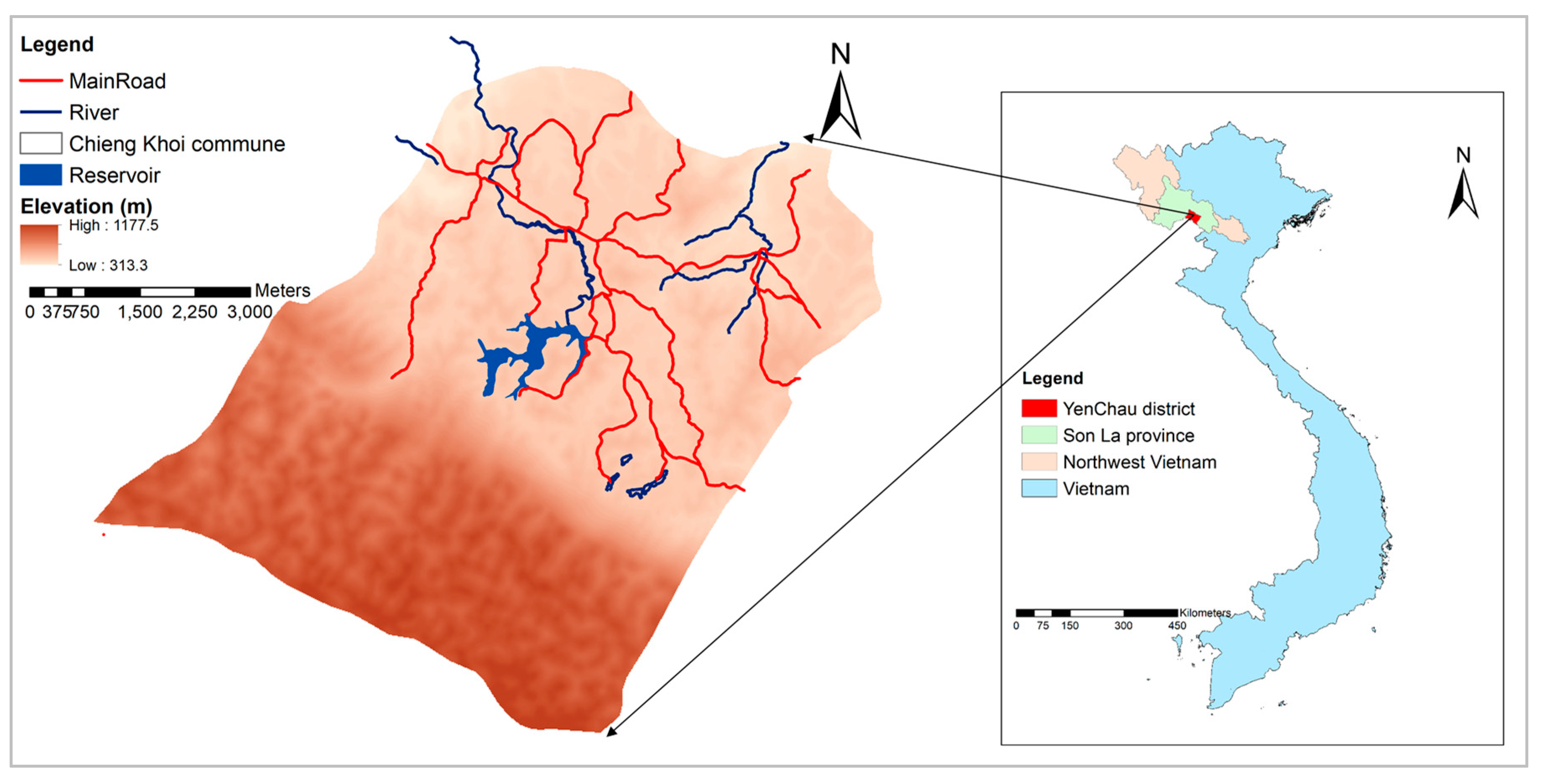
2.1. Study Site
2.2. Participatory Appraisals and Stakeholder Elicitations
2.2.1. Farmer Decision Rules on Crop Choices and Crop Rotation
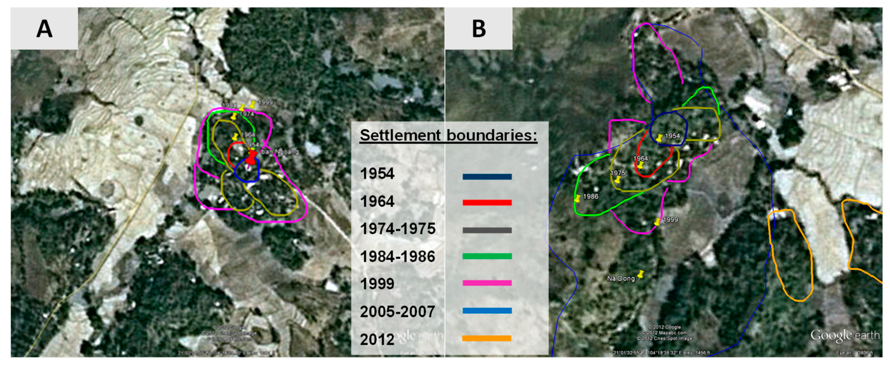
2.2.2. Participatory Mapping
2.3. Ground Truthing, Transect Walks and Plot History
2.4. Earth Observation Data
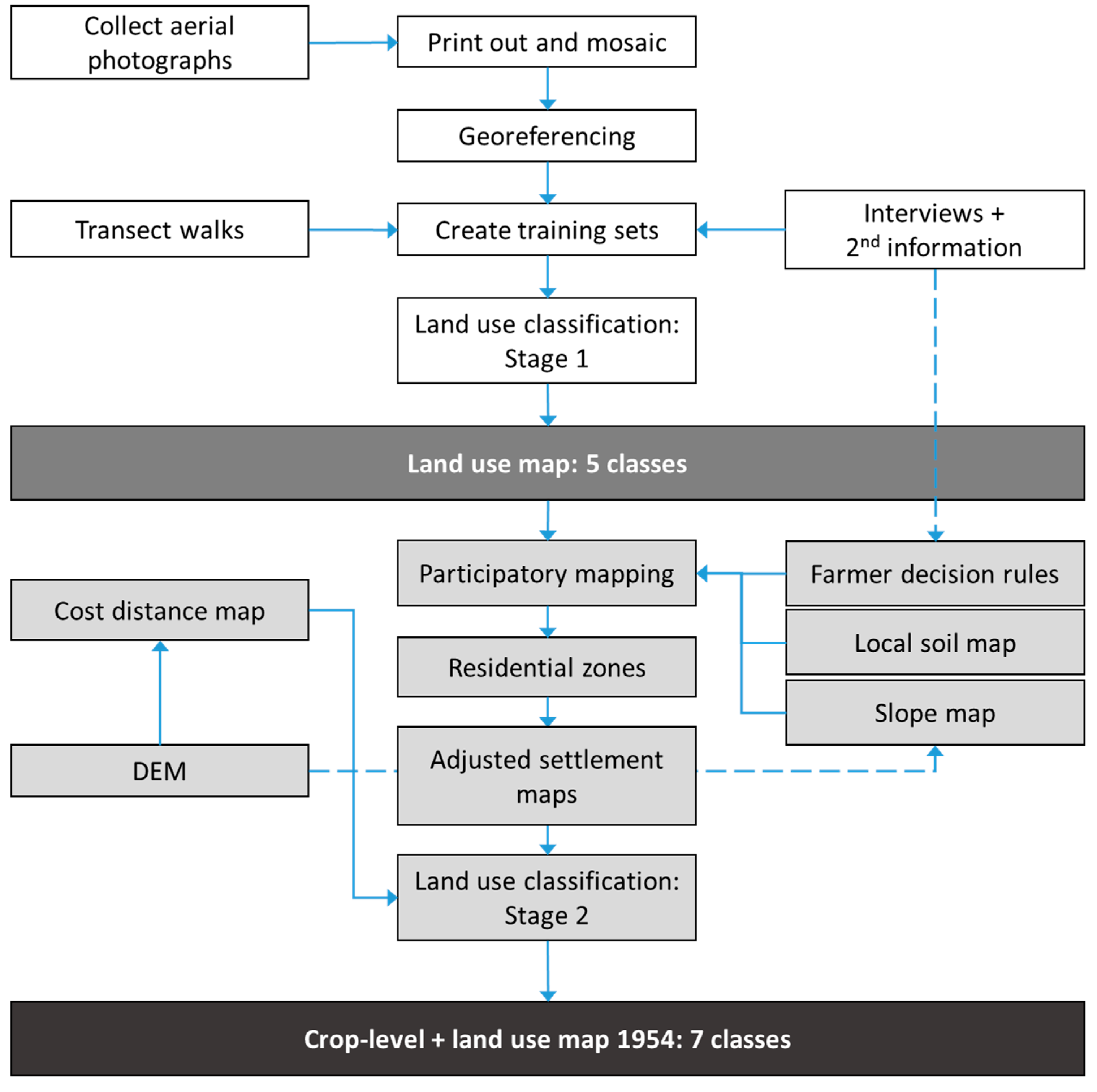
2.5 Integrating Local Knowledge in Land Use Classification Workflow
2.5.1. Stage 1: Land Use Mapping 1954, 1993, 1999, and 2007
2.5.2. Stage 2: Adjusting for Residential Area Expansion and Upland Crop Types in 1954 and 2007
2.6. Accuracy Assessment
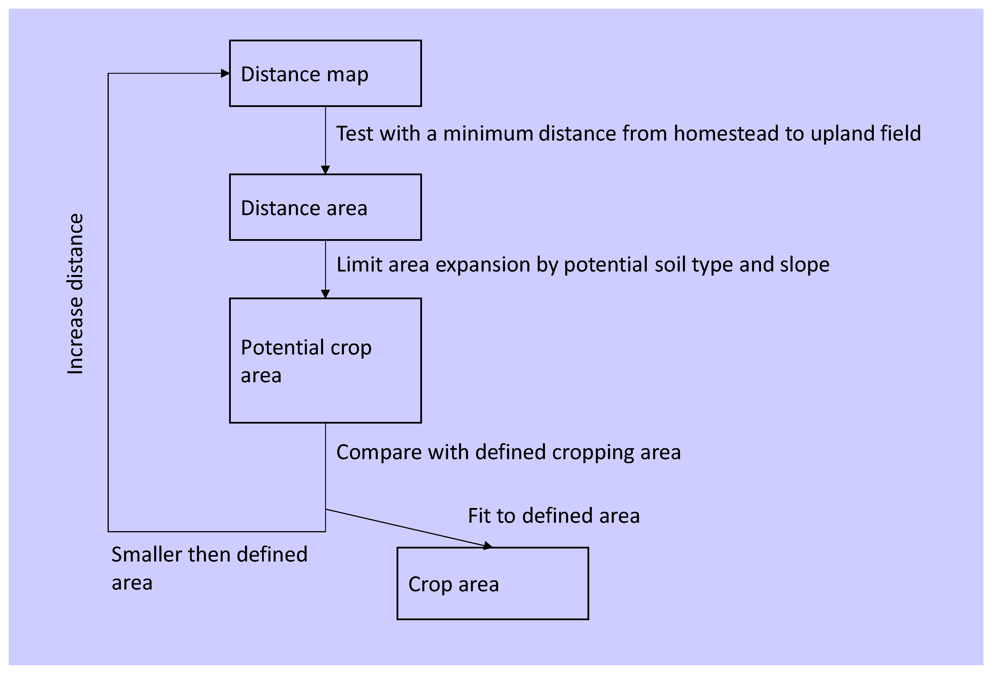
2.7. Upland CroppingAarea Change Detection 1954 and 2007
3. Results
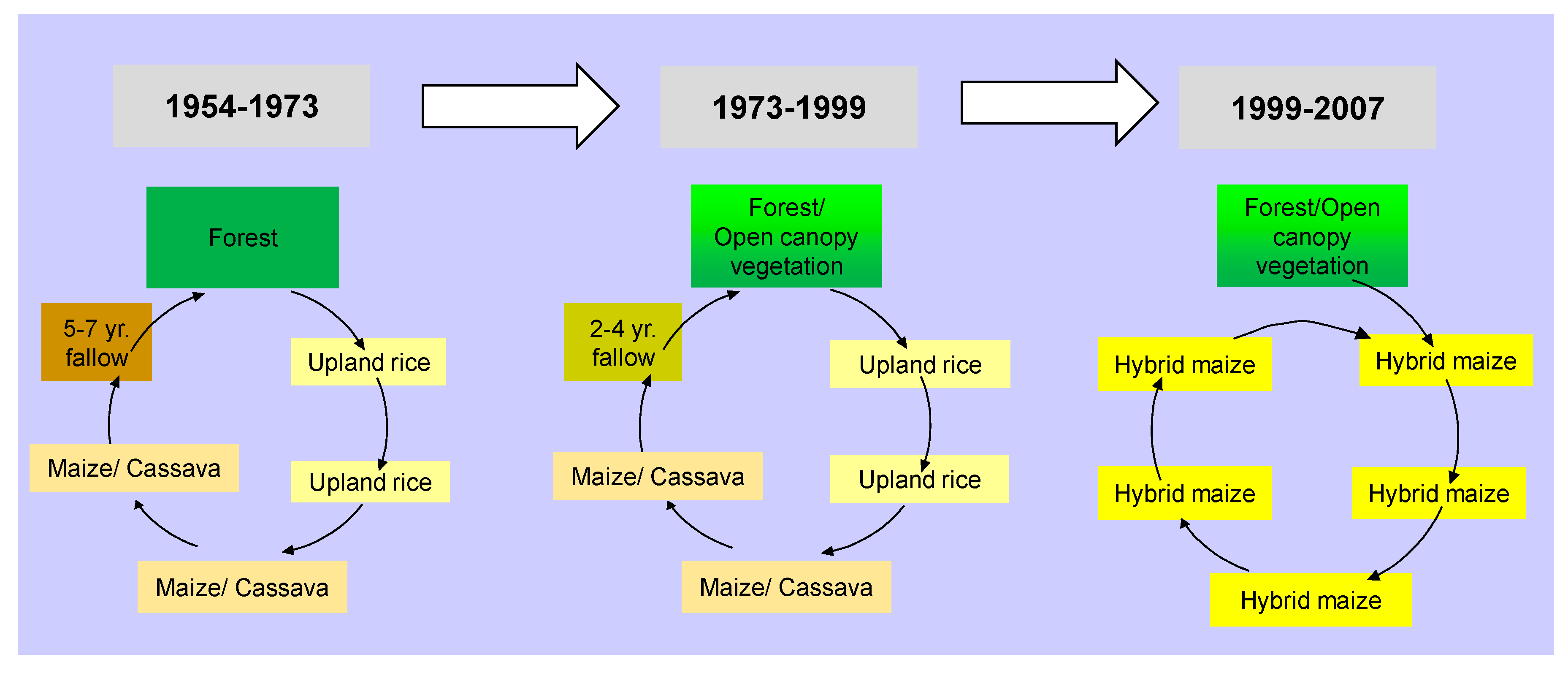
3.1. Farmer Decision Rules and Crop Rotations
3.1.1. Plot-Level Decision Rules
3.1.2. Crop Rotations
- 1954 to 1973, due to the completion of the reservoir in 1974 (establishment started in 1968);
- 1973 to 1993, a transition period where new land laws provided farmers long-term land use rights;
- 1993 to 2007, sub-grouped into:
- ○
- 1993 to 1999, land title rights for agricultural land provided (also referred to as Red Book) was applied in 1999 in Chieng Khoi commune;
- ○
- 1999 to 2007, due to available remote sensing data (here: LISS III).
3.2. Land Use Mapping Using Outcomes of Participatory Procedures
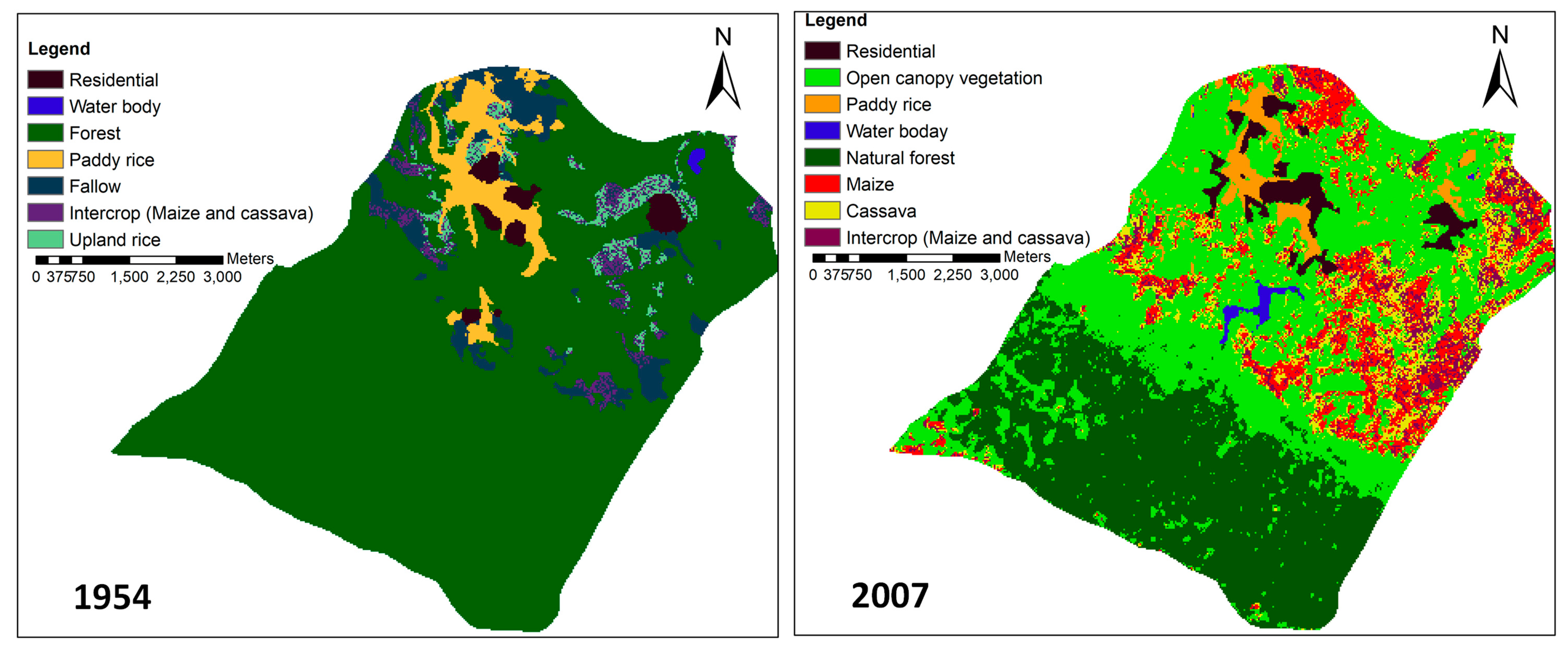
3.3. Crop-Level Classification in 1954 and 2007
3.3.1. 1954
3.3.2. 2007
3.4. Crop Transitions and Expansion
4. Discussion
4.1. Innovative Crop Mapping Approach
4.2. Importance of Local Stakeholders in Classifying Historical Land Use Maps
4.3. Lessons Learned and Implications for Regional Landscape Management
5. Conclusions
Supplementary Materials
Author Contributions
Acknowledgments
Conflicts of Interest
References
- Herzberg, R.; Pham, T.G.; Kappas, M.; Wyss, D.; Tran, C.T.M. Multi-Criteria Decision Analysis for the Land Evaluation of Potential Agricultural Land Use Types in a Hilly Area of Central Vietnam. Land 2019, 8, 90. [Google Scholar] [CrossRef]
- Özdoğan, M.; Baird, I.G.; Dwyer, M.B. The role of remote sensing for understanding large-scale rubber concession expansion in Southern Laos. Land 2018, 7, 55. [Google Scholar] [CrossRef]
- Hurni, K.; Fox, J. The expansion of tree-based boom crops in mainland Southeast Asia: 2001 to 2014. J. Land Use Sci. 2018, 13, 198–219. [Google Scholar] [CrossRef]
- Lillesand, T.M.; Kiefer, R.W. Remote Sensing and Image Interpretation, 4th ed.; Wiley&Sons: West Sussex, UK, 2000. [Google Scholar]
- Bui, T.M.H.; Schreinemachers, P. Resettling Farm Households in Northwestern Vietnam: Livelihood Change and Adaptation. Int. J. Water Resour. Dev. 2011, 27, 769–785. [Google Scholar] [CrossRef]
- Longley, P.A.; Goodchild, M.F.; Maguire, D.J.; Rhind, D.W. Rind Geographical Information Systems and Science; John Wiley &Sons, Ltd.: West Sussex, UK, 2005. [Google Scholar]
- Nyssen, J.; Petrie, G.; Mohamed, S.; Gebremeskel, G.; Seghers, V.; Debever, M.; Hadgu, K.M.; Stal, C.; Billi, P.; Demaeyer, P.; et al. Recovery of the aerial photographs of Ethiopia in the 1930s. J. Cult. Herit. 2016, 17, 170–178. [Google Scholar] [CrossRef]
- Newman, M.E.; McLaren, K.P.; Wilson, B.S. Assessing deforestation and fragmentation in a tropical moist forest over 68 years; the impact of roads and legal protection in the Cockpit Country, Jamaica. For. Ecol. Manag. 2014, 315, 138–152. [Google Scholar] [CrossRef]
- Lippe, M.; Thai Minh, T.; Neef, A.; Hilger, T.; Hoffmann, V.; Lam, N.T.; Cadisch, G. Building on qualitative datasets and participatory processes to simulate land use change in a mountain watershed of Northwest Vietnam. Environ. Model. Softw. 2011, 26, 1454–1466. [Google Scholar] [CrossRef]
- Basupi, L.V.; Quinn, C.H.; Dougill, A.J. Using participatory mapping and a participatory geographic information system in pastoral land use investigation: Impacts of rangeland policy in Botswana. Land Use Policy 2017, 64, 363–373. [Google Scholar] [CrossRef]
- Zaehringer, J.G.; Llopis, J.C.; Latthachack, P.; Thein, T.T.; Heinimann, A. A novel participatory and remote-sensing-based approach to mapping annual land use change on forest frontiers in Laos, Myanmar, and Madagascar. J. Land Use Sci. 2018, 13, 16–31. [Google Scholar] [CrossRef]
- Kibret, K.S.; Marohn, C.; Cadisch, G. Assessment of land use and land cover change in South Central Ethiopia during four decades based on integrated analysis of multi-temporal images and geospatial vector data. Remote Sens. Appl. Soc. Environ. 2016, 3, 1–19. [Google Scholar] [CrossRef]
- Castella, J.-C.; Pheng Kam, S.; Dinh Quang, D.; Verburg, P.H.; Thai Hoanh, C. Combining top-down and bottom-up modelling approaches of land use/cover change to support public policies: Application to sustainable management of natural resources in northern Vietnam. Land Use Policy 2007, 24, 531–545. [Google Scholar] [CrossRef]
- Castella, J.-C.; Trung, T.N.; Boissau, S. Participatory simulation of land-use changes in the northern mountains of Vietnam: The combined use of an agent-based model, a role-playing game, and a geographic information system. Ecol. Soc. 2005, 10, 1–32. [Google Scholar] [CrossRef]
- Lippe, M.; Marohn, C.; Hilger, T.; Dung, N.V.; Vien, T.D.; Cadisch, G. Evaluating a spatially-explicit and stream power-driven erosion and sediment deposition model in Northern Vietnam. Catena 2014, 120, 134–148. [Google Scholar] [CrossRef]
- Schmitter, P.; Dercon, G.; Hilger, T.; Hertel, M.; Treffner, J.; Lam, N.; Duc Vien, T.; Cadisch, G. Linking spatio-temporal variation of crop response with sediment deposition along paddy rice terraces. Agric. Ecosyst. Environ. 2011, 140, 34–45. [Google Scholar] [CrossRef]
- Matthias, R. Everyday Life in Chieng Khoi, Vietnam. An Essay of Assessmen by Using Biographic Interviews; Margraf Publishers: Weikersheim, Germany, 2008. [Google Scholar]
- Pucher, J.G. Nutrient Flow in Improved Upland Aquaculture Systems in Yen Chau, Province Son La (Vietnam). Ph.D. Dissertation, Hohenheim University, Stuttgart, Germany, 2014. [Google Scholar]
- Beuchelt, T. Support Networks of Rural Households. A Case Study of Risk-Management in Northern Vietnam; Margraf Publishers: Weikersheim, Germany, 2008. [Google Scholar]
- Hagel, H. Local Soil Knowledge in Vietnam’s Northern Mountainous Region: A Case Study among Different Ethnic Groups. Master’s Thesis, Institute for Social Sciences of the Agricultural Sector, Department of Rural Communication and Extension, Hohenheim University, Stuttgart, Germany, 2011. [Google Scholar]
- Lippe, M. Simulating the Impact of Land Use Change on Ecosystem Functions in Data-Limited Watersheds of Mountainous Mainland Southeast Asia. Ph.D. Dissertation, Faculty of Agricultural Sciences, Hohenheim University, Stuttgart, Germany, 2015. [Google Scholar]
- Bechstedt, H.D. Socioeconomic Diagnosis for the Evaluation of Sustainable Land Management; Global Tool Kit No. 4; IBSRAM: Bangkok, Thailand, 2000. [Google Scholar]
- Issue 33, Participatory Learning and Action 2001. Available online: https://pubs.iied.org/pdfs/6143IIED.pdf (accessed on 27 August 2019).
- Tran, D.T. Information for Statistic Book for Chieng Khoi Commune 2011; People Committee Yen Chau: Son La Province, Vietnamese, 2011. [Google Scholar]
- Yang, X.; Lo, C.P. Using a time series of satellite imagery to detect land use and land cover changes in the Atlanta, Georgia metropolitan area. Int. J. Remote Sens. 2002, 23, 1775–1798. [Google Scholar] [CrossRef]
- Kadmon, R.; Harari-Kremer, R. Studying long-term vegetation dynamics using digital processing of historical aerial photographs. Remote Sens. Environ. 1999, 68, 164–176. [Google Scholar] [CrossRef]
- Giang, L.T. Assessing the Land Use Changes on Agro Forestry Lands in Yen Chau District, Son La Province Using Remote Sensing Data Analysis. Master’s Thesis, Hanoi University of Agriculture, Hanoi, Vietnam, 2002. [Google Scholar]
- Nguyen, T.T. Assessment of Land cover Change in Chieng Khoi Commune, Northern Vietnam, by Combining Remote Sensing Tools and Historical Local Knowledge. Master’s Thesis, Institute for Plant Production and Agroecology in the Tropics and Subtropics (380a), Universität Hohenheim, Stuttgart, Germany, 2009. [Google Scholar]
- Leisz, S.J.; Ha, N.T.T.; Yen, N.T.B.; Lam, N.T.; Vien, T.D. Developing a methodology for identifying, mapping and potentially monitoring the distribution of general farming system types in Vietnam’s northern mountain region. Agric. Syst. 2005, 85, 340–363. [Google Scholar] [CrossRef]
- Saha, A.K.; Arora, M.K.; Csaplovics, E.; Gupta, R.P. Land cover classification using IRS liss III image and DEM in a rugged terrain: A case study in Himalayas. Geocarto Int. 2005, 20, 33–40. [Google Scholar] [CrossRef]
- Dewan, A.M.; Yamaguchi, Y. Land use and land cover change in Greater Dhaka, Bangladesh: Using remote sensing to promote sustainable urbanization. Appl. Geogr. 2009, 29, 390–401. [Google Scholar] [CrossRef]
- ESRI. 2015. Available online: http://desktop.arcgis.com/en/desktop/latest/tools/environments/resampling-method.htm (accessed on 28 December 2015).
- Clemens, G.; Fiedler, S.; Cong, N.D.; Van Dung, N.; Schuler, U.; Stahr, K. Soil fertility affected by land use history, relief position, and parent material under a tropical climate in NW-Vietnam. Catena 2010, 81, 87–96. [Google Scholar] [CrossRef]
- PCRaster Team PCRaster Documentation. 2011. Available online: http://pcraster.geo.uu.nl/ (accessed on 30 May 2011).
- Zhu, A.-X.; Qi, F.; Moore, A.; Burt, J.E. Prediction of soil properties using fuzzy membership values. Geoderma 2010, 158, 199–206. [Google Scholar] [CrossRef]
- Zhu, A.X.; Hudson, B.; Burt, J.; Lubich, K.; Simonson, D. Soil mapping using GIS, expert knowledge, and fuzzy logic. Soil Sci. Soc. Am. J. 2001, 65, 1463–1472. [Google Scholar] [CrossRef]
- Rounsevell, M.D.A.; Annetts, J.E.; Audsley, E.; Mayr, T.; Reginster, I. Modelling the spatial distribution of agricultural land use at the regional scale. Agric. Ecosyst. Environ. 2003, 95, 465–479. [Google Scholar] [CrossRef]
- Foody, G.M. Status of land cover classification accuracy assessment. Remote Sens. Environ. 2002, 80, 185–201. [Google Scholar] [CrossRef]
- Scepan, J. Thematic validation of high-resolution global land-cover data sets. Photogramm. Eng. Remote Sens. 1999, 65, 1051–1060. [Google Scholar]
- Vittek, M.; Brink, A.; Donnay, F.; Simonetti, D.; Desclée, B. Land Cover Change Monitoring Using Landsat MSS/TM Satellite Image Data over West Africa between 1975 and 1990. Remote Sens. 2014, 6, 658–676. [Google Scholar] [CrossRef]
- Lentz, C.C. Mobilization and state formation on a frontier of Vietnam. J. Peasant Stud. 2011, 38, 559–586. [Google Scholar] [CrossRef]
- Mundia, L. Participatory Mapping Approaches Aided by GIS Technology towards Sustainable Land Use Planning in Namibia; Namibia University: Windhoek, Namibia, 2016; Volume 4. [Google Scholar]
- Brown, G.; Sanders, S.; Reed, P. Using public participatory mapping to inform general land use planning and zoning. Landsc. Urban Plan. 2018, 177, 64–74. [Google Scholar] [CrossRef]
- Nagabhatla, N.; Padmanabhan, M.; Kühle, P.; Vishnudas, S.; Betz, L.; Niemeyer, B. LCLUC as an entry point for transdisciplinary research—Reflections from an agriculture land use change study in South Asia. J. Environ. Manag. 2015, 148, 42–52. [Google Scholar] [CrossRef]
- Keil, A.; Saint-Macary, C.; Zeller, M. Intensive commercial agriculture in fragile uplands of vietnam: How to harness its poverty reduction potential while ensuring environmental sustainabiliry? Q. J. Int. Agric. 2013, 52, 1–25. [Google Scholar]
- Tuan, V.D.; Hilger, T.; MacDonald, L.; Clemens, G.; Shiraishi, E.; Vien, T.D.; Stahr, K.; Cadisch, G. Mitigation potential of soil conservation in maize cropping on steep slopes. Field Crops Res. 2014, 156, 91–102. [Google Scholar] [CrossRef]


| Source | Aerial photograph 1954 | Landsat TM 1993 | Landsat ETM+ 1999 | IRS LISS III 2007 |
|---|---|---|---|---|
| Pixel (m) | 5 | 30 | 30 | 5.8 1 |
| Date | na 2 | 1 February 1993 | 27 December 1999 | 4 March 2007 |
| Season | na | dry | dry | late dry season |
| Sensor | na | TM | ETM+ | self-scanning |
| No | LU Type | Description |
|---|---|---|
| 1 | Forest | Dense primary forest and dense secondary forest, fallow *, 7 years or older with medium and large trees (≥10 m) |
| 2 | Residential area | Location of farmers’ houses ** |
| 3 | Open canopy vegetation | Mixture of small trees, bush, fruit trees, and planted forests that resemble less dense canopy vegetation (not in 1954) |
| 4 | Paddy rice | Low elevation and flat areas where water level is low and that become dry during dry season |
| 5 | Water body | Lake or ponds larger than 2500 m2 (excluding small streams and rivers of ≤10 m width) |
| 6 | Upland cultivation | Crop areas cultivated on areas with slopes >5° and elevation >300 m above sea level, also including young fallow stages (1–6 years of age), with grass and bushes. |
| Rank | Name of Crops * | Reasons |
|---|---|---|
| 1st | Paddy rice and upland rice | Staple crop, both paddy rice and upland rice were the first choice as both revealed no area competition. Paddy rice was planted on flat land or terraces while upland rice was planted in upland areas without irrigation. |
| 2nd | Three years cassava ** | Staple crop which was not common before 1950s, but became more frequent and important after 1954 until 1990s. Crop served as important starch source in the household. |
| 3rd | Maize *** | Additional food for home consumption with low crop yields (>0.5 Mg per ha), grown in upland fields following upland rice and often used as livestock feed |
| 4th | Peanut | Additional food source and added as a flavor for household meals |
| No | Land Use Types | Area (ha) | |||
|---|---|---|---|---|---|
| 1954 | 1993 | 1999 | 2007 | ||
| 1 | Forest | 2595 | 1146 | 1303 | 929 |
| 2 | Residential | 4 | 20 | 44 | 44 |
| 3 | Open canopy vegetation | 51 | 1552 | 1239 | 1317 |
| 4 | Paddy rice | 140 | 83 | 92 | 110 |
| 5 | Water body | 4 | 18 | 26 | 17 |
| 6 | Upland cultivation | 315 | 308 | 423 | 708 |
| Total * | 3109 | 3127 | 3127 | 3125 | |
| Crops | Maximum Distance to Homestead (m) | Additional Criteria | Area (ha) |
|---|---|---|---|
| Upland rice | 1100 | Good soil, non-stony, first consideration of area with slope ≤ 50% then to slope ≤ 100% before increasing distance. | 63 |
| Maize and cassava | 1600 | Good soil, non-stony soil, slope ≤ 100%, excluding upland rice areas. | 64 |
| Fallow | 2140 | In upland cultivation area, slope ≤ 100%, excluding areas which were planted with upland rice, maize, and cassava. | 188 |
| Total | 315 |
© 2019 by the authors. Licensee MDPI, Basel, Switzerland. This article is an open access article distributed under the terms and conditions of the Creative Commons Attribution (CC BY) license (http://creativecommons.org/licenses/by/4.0/).
Share and Cite
Nguyen, T.T.; Lippe, M.; Marohn, C.; Duc Vien, T.; Cadisch, G. Using Farmer Decision Rules for Mapping Historical Land Use Change Patterns from 1954 to 2007 in Rural Northwestern Vietnam. Land 2019, 8, 130. https://doi.org/10.3390/land8090130
Nguyen TT, Lippe M, Marohn C, Duc Vien T, Cadisch G. Using Farmer Decision Rules for Mapping Historical Land Use Change Patterns from 1954 to 2007 in Rural Northwestern Vietnam. Land. 2019; 8(9):130. https://doi.org/10.3390/land8090130
Chicago/Turabian StyleNguyen, Thanh Thi, Melvin Lippe, Carsten Marohn, Tran Duc Vien, and Georg Cadisch. 2019. "Using Farmer Decision Rules for Mapping Historical Land Use Change Patterns from 1954 to 2007 in Rural Northwestern Vietnam" Land 8, no. 9: 130. https://doi.org/10.3390/land8090130
APA StyleNguyen, T. T., Lippe, M., Marohn, C., Duc Vien, T., & Cadisch, G. (2019). Using Farmer Decision Rules for Mapping Historical Land Use Change Patterns from 1954 to 2007 in Rural Northwestern Vietnam. Land, 8(9), 130. https://doi.org/10.3390/land8090130