Article

Evolution and Collapse of Ejidos in Mexico—To What Extent Is Communal Land Used for Urban Development?

by
Melissa Schumacher
1,
Pamela Durán-Díaz
2,*,
Anne Kristiina Kurjenoja
3,
Eduardo Gutiérrez-Juárez
4 and
David A. González-Rivas
5
1
Department of Architecture, Universidad de las Américas Puebla, Cholula 72810, Mexico
2
Associate Professorship of Land Management, Technische Universität München, 80333 Munich, Germany
3
Department of Architecture, Universidad de las Américas Puebla, Cholula 72810, Mexico
4
Department of Architecture, Universidad de las Américas Puebla, Cholula 72810, Mexico
5
Centro de Investigaciones Biológicas del Noreste CONACYT, La Paz Baja California Sur 23205, Mexico
*
Author to whom correspondence should be addressed.
Land 2019, 8(10), 146; https://doi.org/10.3390/land8100146
Submission received: 13 September 2019 / Revised: 26 September 2019 / Accepted: 2 October 2019 / Published: 7 October 2019
(This article belongs to the Special Issue Land Tenure and the Future of Cities)

Abstract

:
The ejido system, based on communal land in Mexico, was transformed to private ownership due to neoliberal trends in the 1990s. Based on the theory of stakeholders being agents of change, this study aimed to describe the land policies that changed the ejido system into private development to show how land tenure change is shaping urban growth. To demonstrate this, municipalities of San Andrés Cholula and Santa Clara Ocoyucan were selected as case studies. Within this context, we evaluated how much ejido land is being urbanized due to real estate market forces and what type of urbanization model has been created. These two areas represent different development scales with different stakeholders—San Andrés Cholula, where ejidos were expropriated as part of a regional urban development plan and Santa Clara Ocoyucan, where ejidos and rural land were reached by private developers without local planning. To analyze both municipalities, historical satellite images from Google Earth were used with GRASS GIS 7.4 (Bonn, Germany) and corrected with QGIS 2.18 (Boston, MA, US). We found that privatization of ejidos fragmented and segregated the rural world for the construction of massive gated communities as an effect of a disturbing land tenure change that has occurred over the last 30 years. Hence, this research questions the roles of local authorities in permitting land use changes with no regulations or local planning. The resulting urbanization model is a private sector development that isolates rural communities in their own territories, for which we provide recommendations.

1. Introduction

Mexico has an intricate land tenure system with historical bonds between communal lands and a combination of public and private ownership. The ejido (from the Latin word exitus or way-out, refers to the fields outside human settlements or towns for cattle or orchards. In the case of Altépetl (see Note 4), ejido refers to the land outside of the calpulli for agricultural purposes) is an endemic land tenure model and one of the most important bequests of the Mexican Revolution, consisting of “an area of communal land used for agriculture, on which community members individually farm designated parcels and collectively maintain communal holdings” [1].
As a system, the ejido has been widely studied in Mexico and Latin America because of its complexity and importance as an agrarian land policy [2,3,4], its fragile socioeconomic structure [1], [5,6], its socio-spatial organization [7,8,9], its urbanization [10,11,12] and its liberalization [13,14,15] through the reforms of Article 27 of the Mexican Constitution. Most ejido land underwent a transformation in response to neoliberal trends during the 1980s and 1990s, when private ownership was secured by ejidatarios and farmers, which, despite appearing to be a positive step, subsequently opened the door to corporate predation due to ejido land being considered as potential urban land.
Ejidos were the axiom of Mexico’s rural land distribution, until they became an obsolete tenure system that did not achieve better quality of life or wealth for its tenants. The paradox of the ejido system is that although it is going extinct because it is considered an “irregular land tenure system” by modern land policies, half of Mexico’s territory is still held by ejidos and rural communities, including mountains, forests, natural reserves, mines and lakes, among others.
“More than 5.6 million ejidatarios offer food, cattle, raw materials, fodder, as well as construction materials, handcrafts and touristic services to National and international markets. Moreover, they provide invaluable environmental services for biodiversity conservation, carbon capture and aquifer recharge” [16].
Nevertheless, as land speculators crave cheap, available land to invest in, the privatization of ejido tenure in peri-urban areas leads to agricultural and natural lands becoming potentially urban in order to accommodate such investments. After the last Land Reform and liberalization of ejidos in 1992, low-priced ejidos and rural land were available for the big housing market, especially when conurbated with urban areas. Through this public policy and the influence of stakeholders, the urbanization of ejidos caused massive urban sprawl outside urban cores and thus huge peri-urban areas emerged.
An “irreversible urbanization process” [17] was triggered by the privatization of ejido land and the subsequent immiseration of many Mexican farmers. This jeopardized the survival of the agrarian sector and merged new socio-spatial processes. Within this, one of the greatest tragedies for Mexican and Latin American rural communities is that rural land use will sooner or later cease [18]. Nonetheless, Barnes [19] considers that ejido and rural communities are some of the most resilient communities in the world, as they have been able to adapt and transform their identities and economies. This type of adaptation has led, as a consequence, to stakeholder linkages between interests, affectations and benefits, resulting in a fractured urban territory with alternating urban developments, agricultural zones and natural reserves [20].
This paper contributes to the research on ejidos and peri-urban growth in order to answer three main questions—I. How much ejido and rural land is being used for urban development in the case study areas? II. How does land tenure change the shape of urban growth in Mexico? III. Which model of urbanization emerges from this? To respond to these questions, we first review the evolution of ejidos as a land tenure system in Mexico. Second, we conduct a visual geo-analysis of satellite images, selecting the municipalities of San Andrés Cholula and Santa Clara Ocoyucan as traditional ejidos to use as case studies and we quantify their urbanization from 1995 to 2018. Both case study areas have undergone different urbanization processes, despite having similar socio-spatial and economic features, in terms of having a native rural population relying on communal land tenure and on a mainly agrarian economy.
This research is divided into four sections. First, we present a theoretical framework on the premise of stakeholders acting as agents of change that drive urban development; second, we outline our approach to the evolution and collapse of the ejido land tenure system in Mexico; third, we conduct a geo-visual analysis to measure how much land was urbanized in the areas under study; fourth, we provide our results and discussion to critically assess private sector urbanization of ejido land and the roles of land tenure change and stakeholders in promoting land privatization; and finally, we conclude that the tendency of the model of urbanization based on private development to isolate rural communities in their own territory means that the benefits are outweighed by the negative impacts.

2. Theoretical Framework—Stakeholders as Agents of Socio-Spatial Change

Population growth, decentralization of socioeconomic activities, flows and goods, fragmentation of the environment and new centralities, among others, are factors that plays role in expansive urban growth [21] and the production and control of urbanization [22]. These factors rely on key agents who (pro-) actively pursue their roles, interests and affectations, that is, stakeholders. In line with the definition set by the World Bank [23] stakeholders are agents of change when they can participate as decision-makers with positive or negative goals and when their stakes or interests can be connected to either individual or collective preferences towards change [24]. In other words, stakeholders are able to both change public policies and influence local reality as a manifestation of their socioeconomic and cultural values [25]. This constructivist view of stakeholders affects the choices and processes of spatial development. Stakeholders guide urban growth as both pro-active decision-makers on where and how space is planned and implemented and as affected or benefited actors in urban growth through their day-to-day transactions with each other, (non-) compliance to rules and regulation, and/or conformance or resistance to plans. This intrinsic relationship between stakeholders and the transformation of space and in particular of ejidos, is key to understanding why looking at land tenure changes is a crucial mechanism to understand the processes of conversion from ejido land to peri-urban land.
López-Tamayo [26] proposed that the rise of capitalist society is increasingly transforming urban land use planning into a process of optimizing capital production. In addition, Harvey [27] stated that urban land use choices are increasingly becoming the products of stakeholders seeking profits and revenues. Both authors’ statements were used to form our analytical approach [28]. We first analyzed how and where urban growth is occurring (i.e., which kinds of optimization and priority setting processes seem to take place) and secondly, how socio-spatial construction is done by stakeholders (i.e., which values and exchange mechanisms seem to be involved).
In this regard, we consider the concept of stakeholders acting as agents of socio-spatial change to be relevant, as it describes how rural land is transformed into urban land, where stakeholders act as decision-makers who influence and construct the urban space and indirectly influence the effectiveness of local policies, urban planning practices, segregation of the rural population and housing demand. According to Schumacher’s conceptual framework, based on López-Tamayo and Harvey [27], agents of change use land tenure as one of the mechanisms that triggers the private sector urbanization of former ejido land and transforms peri-urban morphology.
Notwithstanding, the rural identity of peri-urban and agrarian communities is the core of Latin America’s struggle for land rights; thus, it is elementary to understand rural–urban ambiguity, where socioeconomic groups are physically and socially fragmented.

3. Historical Background—the Ejido Land Tenure System Approach

At the end of Colonial period in 1821, when Mexico achieved independence from the Kingdom of Spain, the new country inherited a complex land tenure system including the following:
  • Communal land—the pre-Hispanic ejido and Altépetl (“Water-mountain” in Náhuatl language, was a complex socio-spatial and political system that gave order to former Mesoamerican cities. Each Altépetl had its own government as a City state and its own communal land outside the core areas for agricultural purposes. This was the primordial land tenure system in Mesoamerica and one of the factors influencing modern ejido implementation) system;
  • Public land—owned by the Spanish Crown;
  • Private land—owned by the Church and property owners or hacendados, which represented the new upper-middle-agrarian class.
During the 19th Century, Mexico took its first steps towards regulating the colonial system through land reforms. Wilkie and Hammond [28] consider 1853 as the year that modern land policy was initiated. This marked the beginning of the new function of the federal government as the National land administrator. President Benito Juárez introduced the policy from 1855 to 1861, when the Catholic Church’s property, including haciendas and communal land from native groups, was confiscated to be used as small agrarian holdings.
The industrialization of the country in the 19th century boosted the monopolization of land and water resources for industrial production by hacendados, endorsed by the dictatorship of President Porfirio Díaz which was established in 1876. Wilkie and Hammond observed that, in comparison with former tenure policies, Porfirio Díaz radically changed land ownership from individual and communal properties to massive estates for proprietors and infrastructure development. Mining concessions, extensive farmland and more than 20,000 km of railway were built by foreign companies—mainly from the USA and the UK—during the dictatorship. This was made possible by expropriation due to an ineffective land tenure policy [29].
The routing of railways over rural land was based on connecting production with trading centers, that is to say, haciendas and industries being linked to cities by infrastructure. For this reason, the importance of haciendas in Mexico is twofold—on the one hand, the haciendas represent an unfair socioeconomic and labor exploitation system; on the other hand, the haciendas catalyzed modern agrarian production in Mexico. Some key features of the industrialization of the agrarian sector are land tenure, capital, cheap labor, technology and organization, as shown in Table 1. Although relatively small groups of hacendados controlled these features, most of the communal and native land suffered land tenure insecurity due to private appropriation and government expropriation.
Unable to make a living, and under the imminent threat of their lands either being grabbed by hacendados or expropriated by the Government, in 1910 farmers, workers and peasants came together to resist them in what was to become the Mexican Revolution. This social movement, spearheaded by farming and peasant leaders, such as Emiliano Zapata, who fought for the restitution of lands to their original owners, sought for democracy and social justice under the banners of “Land and Liberty” and “the land belongs to those who work it with their hands.”
It should be noted that the development of the Mexican Revolution was different in the North and South of Mexico. According to Katz [29], the social movement in the northern states was guided mainly by the rural middle class, working class and hacendado (most of the generals in the North were owners of small and large areas of rural land but the famous General Francisco “Pancho” Villa was a former hacienda worker and outlaw) who stood against the political system. The government of Porfirio Díaz favored the use of foreign companies in the development of mining, railroads, livestock and industrial agriculture in Mexican territory. In the south-central area of the country, the revolution had a strong ideology based on political change, social justice for peasants and the restitution of ancient lands to their original owners (for example, old Altépetl communal land and territories). In contrast, in the North, hacendados did not join the revolutionary forces and peasants were incited to fight against hacendados, supported by intellectuals, workers and local leaders.
The Mexican Revolution was the beginning of an extensive Land Reform that attempted to fulfill the land rights of peasants and indigenous people. In 1917, the addition of Article 27 to the Mexican Constitution conveyed the declaration of National ownership of water and territory to grant the State the right to secure tenure and private property. It also recognized three types of tenure—public, private and communal. With the stabilization of democracy, the Agrarian Reform (1920–1934) was launched as the modern land policy following the rise of the Mexican Revolution. In 1915, the Agrarian Law was created as a National land policy that ensured communal land tenure through ejidos and was an axiom of the Mexican Revolution’s ideals during the 20th Century. The aim of the Agrarian Law was to enable land distribution through the conversion of haciendas into ejidos as a type of communal land. As stated by Assenatto and de León [30], the ejido is a communal land tenure system that ensures the rights to use farmland, conduct collective activities and establish rural settlements. Furthermore, widely used since pre-Hispanic times, the modern ejido system granted ejidatarios the right to be communal landowners.
Due to its function as a social tenure system, the ejidos used to be divided into land for human settlements close to urban populations, communal land protected by the community and agricultural plots that were the basis for ejido tenure rights [31]. Therefore, an ejidatario was granted the rights to use the land but was not given legal ownership, because all ejido land was labeled as National goods. Robles stated that a typical ejido comprised 1822 hectares distributed among 104 ejidatarios. Normally, an ejido of this size would be divided in 134 plots of a maximum of 10 hectares each. The area for human settlements for ejidatarios and neighbors to live in had an average of 9.4 hectares per ejido [32].
Formerly, in order to acquire ejidal rights, a candidate needed to have inhabited and been registered in the rural community. A community assembly supported by a technical committee evaluated each request to be recognized as an ejidatario. After three assemblies, each new ejidatario was granted circa 8.8 hectares, varying from one geographic location to the other, depending on the availability of fertile land.
Warman’s [17] studies of the 20th century’s agrarian census observed that, throughout the 60 years of the Agrarian Reform history, 50% of Mexican territory was distributed to 3.5 million ejidatarios among more than 30,000 ejidos. Despite the fairness of the distribution of agricultural land based on an effective land policy, the agrarian economy and the living conditions of the rural population did not improve, as they lacked the ability to carry out further responsible investments in tenure, capital, labor, technology and organization. This meant that, while the ejido system did amend land tenure security for peasants and indigenous people, the government subsidies did not result in a reform of labor conditions or in an upgrade of agrarian technology for small producers.
Thus, the Revolution’s promise of land justice and land rights was not fulfilled, as the lack of governmental capacity to improve the agricultural economy and the constant socioeconomic struggle in rural areas triggered a simultaneous migration of rural inhabitants to big cities and the U.S. as a permanent feature of 20th century urban growth. This situation has deteriorated since 1992 when the liberalization of ejido land and the negotiations of the North America Free Trade Agreement (NAFTA) occurred.
Agrarian reforms have continuously reshaped the distribution of land, for example, the 7000 ejidos that existed in 1935 multiplied to 29,983 agrarian nuclei by 1991 at the end of the agrarian distribution. However, their number had decreased to 29,942 by 2007 following neoliberal socioeconomic change [33].
The modification and liberalization of land policies was justified by the Federal government, first as a necessary measure for improving tenure security and allowing the “privatization of communal resources” [34] and second, to regulate informal settlements that were developed in peri-urban ejido land. Some large consequences that occurred with the reform of Article 27 from the Mexican Constitution were the expropriation of ejido land in the outskirts of the cities for private urban development, land use change from productive agricultural land into massive social housing developments and migration to the United States. According to Verea [35], “the undocumented population in the U.S. tripled during the NAFTA era.” In 1994 there were about 3.8 million illegal Mexicans and this peaked in 2007 with 12.2 million illegal Mexicans. This phenomenon is associated with the introduction of subsidies for foreign farm products, against which small scale farmers were not able to compete.
After the reforms to Article 27 in 1991, the process for recognizing the private property of ejidatarios was carried out by local assemblies based on Article 56 of the National Agrarian Law. This legal change transformed the legal protection status of ejidos into untouchable and indissociably goods; thus, assemblies were the entity to grant private ownership to ejidatarios. The Certification Program for Ejido Rights (PROCEDE) (nowadays, the certification program is the responsibility of the National Institute of Sustainable Land, formerly known as CORETT) was the Federal program responsible for the described procedure.
Privatization of ejido tenure means, thus, that agricultural and natural land are potentially urban areas. Adding ejido and communal land to urban development has occurred through different approaches, described by Riveros Fragoso in terms of their urban impact, ecological implications, transformation of the rural economy, socioeconomic issues, land policies and governance accountability [36]. The legal and tenure approach, however, has not been addressed before, although it is essential to get an integral understanding of the implications of the urbanization of the rural world.
Riveros Fragoso dentified three main periods for ejido land incorporation into urban land use—1940–1973 (irregular tenure), 1970–1992 (regularization of ejidos) and 1992 until today (de-regularization of ejidos). During this latter period, the last Ejidal Census of 2007 counted 3,097,658.83 hectares of ejido land sold to buyers outside of rural communities. From 2017, the Agrarian Census recorded a decrease in the number of ejidos in Mexico from more than 31,000 to 28,000. While the number of ejidos has decreased at a rate of 10% over the last ten years, more than 198.5 million hectares of the National territory are still communal-based land tenure, such as ejidos.
These conditions were faced in the municipalities of San Pedro Cholula and San Andrés Cholula in the Metropolitan Area of Puebla-Tlaxcala, where the lifestyles of the rural population changed radically when the regional Government expropriated in 1993 [37,38,39]. Specifically, 1092 Hectares of ejido land was used for the implementation of an urban development plan called “Programa de Ordenamiento Territorial Angelópolis” (PROTA)—commonly known as Plan Angelópolis.
The implementation of PROTA was an exemplary case of urban planning in Mexico that shaped urban growth and gave tenure security to ejidatarios and farmers. Nonetheless, during its implementation, the plan triggered the fragmentation of ejidos and the segregation of the rural population [18]. These twin effects fueled the current debate about modern land policies in Mexico and the extent to which they promote urban-private development in the country.

4. Methods—Quantification and Analysis of Case Study Areas

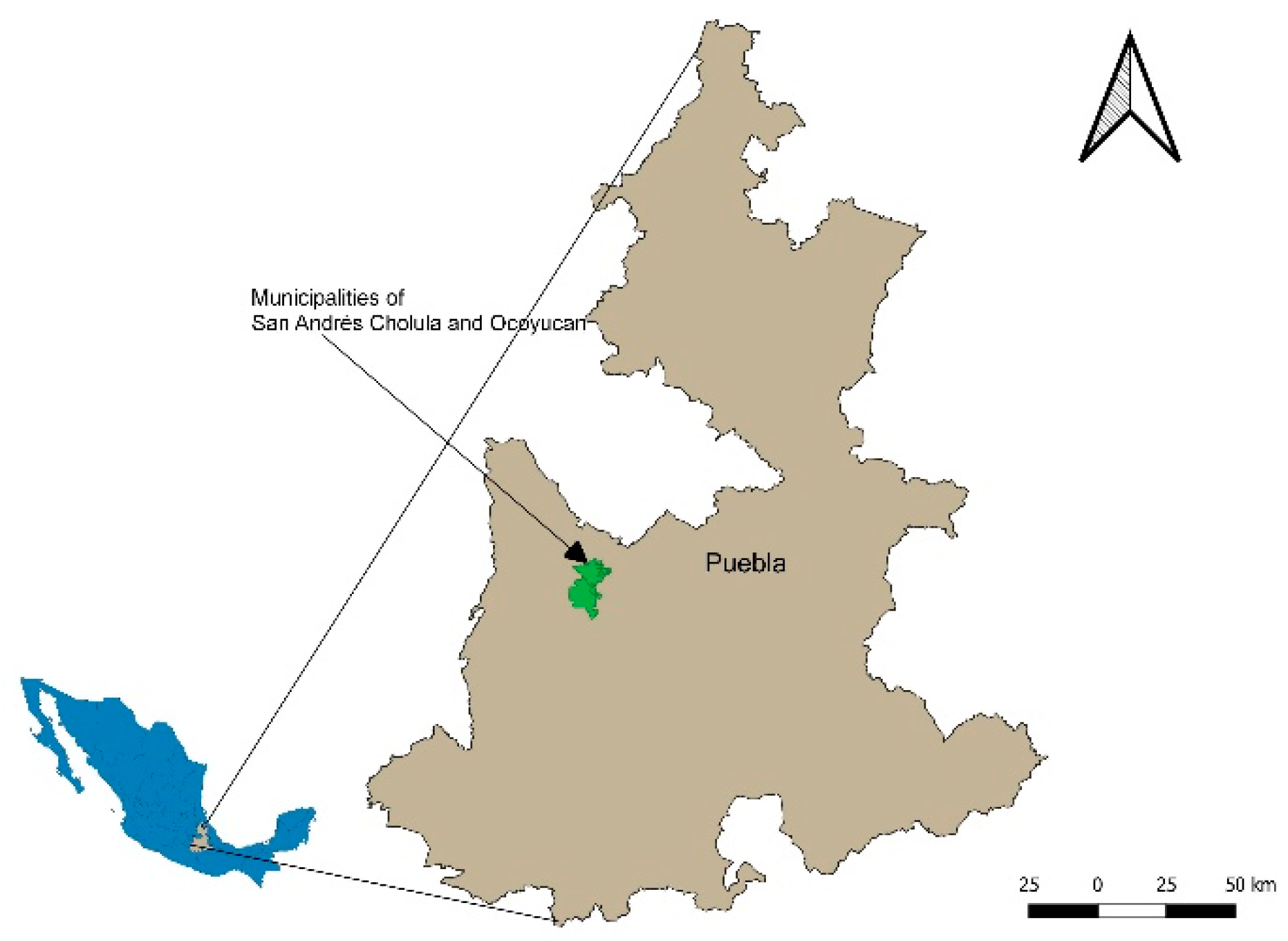
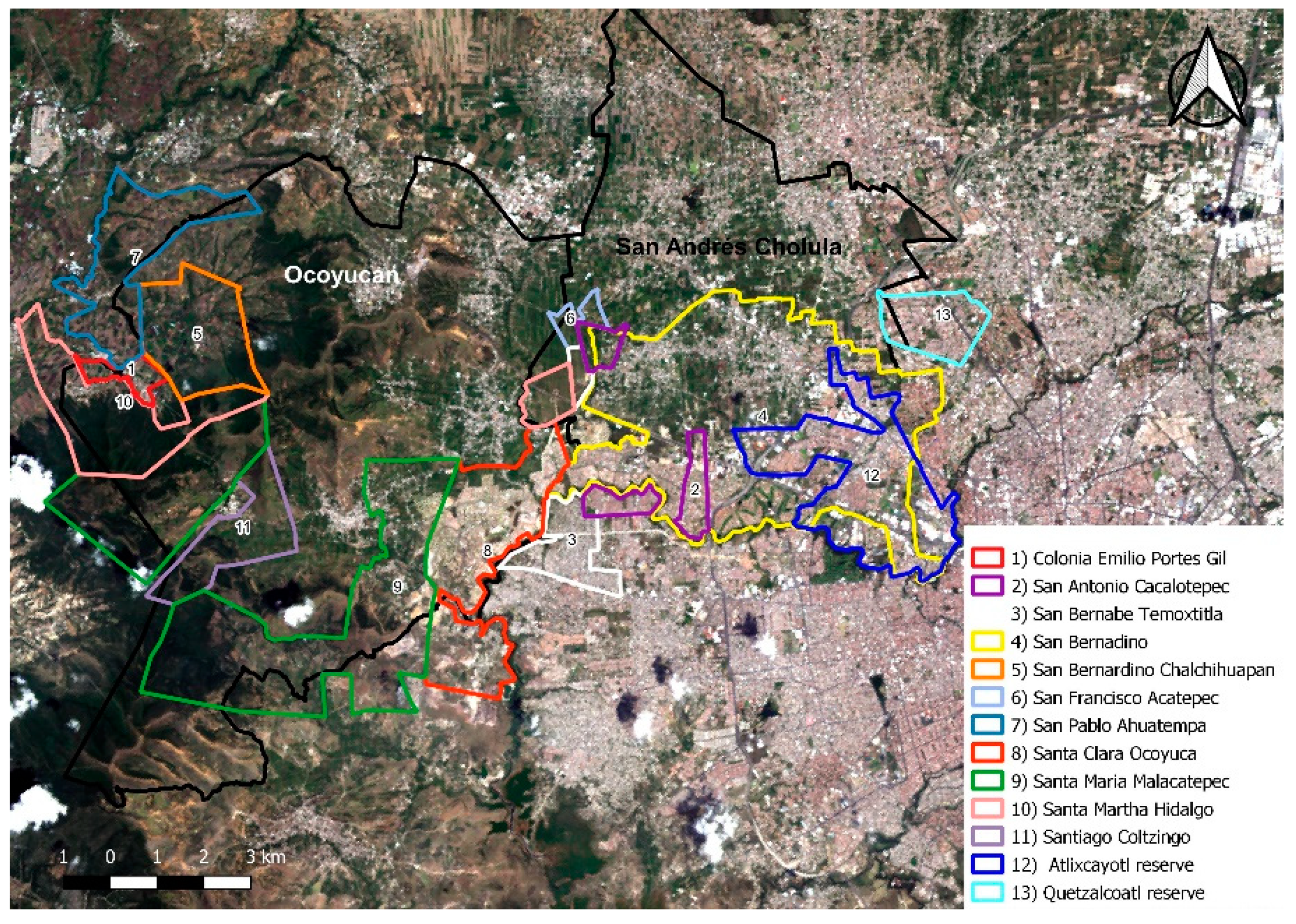
4.1. Case Study Descriptions

The municipalities of San Andrés Cholula and Santa Clara Ocoyucan are part of the Metropolitan Area of Puebla-Tlaxcala, located 120 km from Mexico City. Both towns share a physical conurbation with the city of Puebla and had a largely agricultural economy until the late 20th Century (Figure 1).
Due to the liberalization of ejido land, in 1992, Puebla’s Government created a metropolitan plan that was first called Programa Regional de Ordenamiento Territorial Angelópolis (PROTA) and then updated to Programa de Desarrollo Regional Angelópolis (PDRA). As part of this plan, the land reserve “Reserva Territorial Atlixcáyotl-Quetzalcóatl” was created through a sub-regional implementation plan, Programa Sub-regional de Desarrollo Urbano de los Municipios de Cuautlancingo, Puebla, San Andrés Cholula y San Pedro Cholula (PSDUM), in 1994 (the PSDUM was updated five times—in 1997, 1998, 2000, 2004 and 2011). This sub-regional plan managed future urban growth for several municipalities and promoted housing development to fulfil immediate population needs.
For the creation of the land reserve, 1092 hectares of ejido land from the region of Cholula—from the municipalities of Cuautlancingo, San Pedro Cholula and San Andrés Cholula—were expropriated [40]. In addition to the mentioned municipalities, the master plan included 33 other localities with the purpose of generating the first integrated metropolitan development plan through PROTA [41]. Locally, the urban development plan was carried out through PSDUM [42] in which, for the first time, the urban context was considered as a whole. At regional and municipal levels, urban development plans are the most important implementation instrument. Thereupon, without operative programs, plans are ineffective, especially at a local level, as they must contend with the construction regulations, land uses, density, zoning and cadaster included in the municipal urban development programs.
In 1995, San Andrés Cholula began its urban metropolization process with the implementation of PDRA and Santa Clara Ocoyucan. This mainly occurred from 2010 onwards when private developers bought cheap ejido land in order to catalyze urban development. The names and sizes of ejidos from both municipalities are presented in Table 3.
In 2018, the Sustainable Urban Development Program of San Andrés Cholula recognized 5943.95 Ha (95.63%) of the municipal territory as being private property and the remaining 271.53 (4.37%) as being ejido tenure [41]. On the other hand, according to the 2016 Ejidal Census, the land tenure system in Santa Clara Ocoyucan consisted of mainly ejido tenure (5533.44 Ha, 52.76%) and only 1603.70 Ha (15.29%) of privately owned land from a total of 10,487 Ha of municipal territory. The remaining land was the natural reserve of Sierra del Tentzo [43,44].
Although Santa Clara Ocoyucan was not considered part of PDRA implementation and urban growth, the housing market demand turned the area into a new area for residential development due to the flexibility of the urban regulations—a legacy of its status as a former rural municipality. Nowadays, both locations present a modern urban image with luxury residential areas and towers, gated communities and several shopping and entertainment centers. Table 2 shows the population growth in the case study areas in order to allow readers to visualize the extent to which both municipalities have developed in comparison to the main urban core, Puebla and the whole Metropolitan Area of Puebla-Tlaxcala. The latest statistics are based on the National Census of 2010, Metropolitan Statistics from CONAPO (Consejo Nacional de Población – National Population Council) [45] and National Polls from 2015 [46,47]; however, it would be worthwhile monitoring the results from the next National Census in 2020.

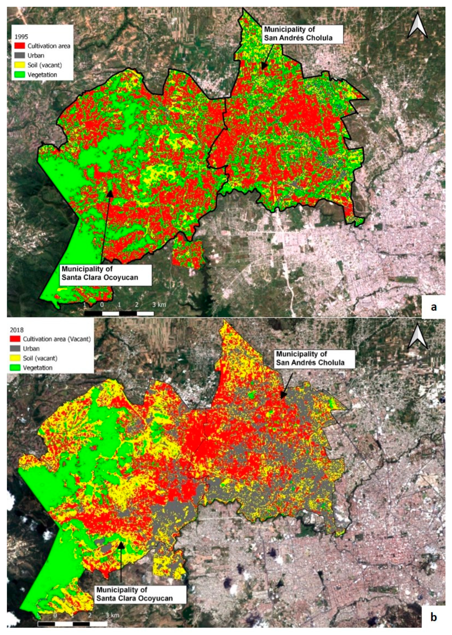
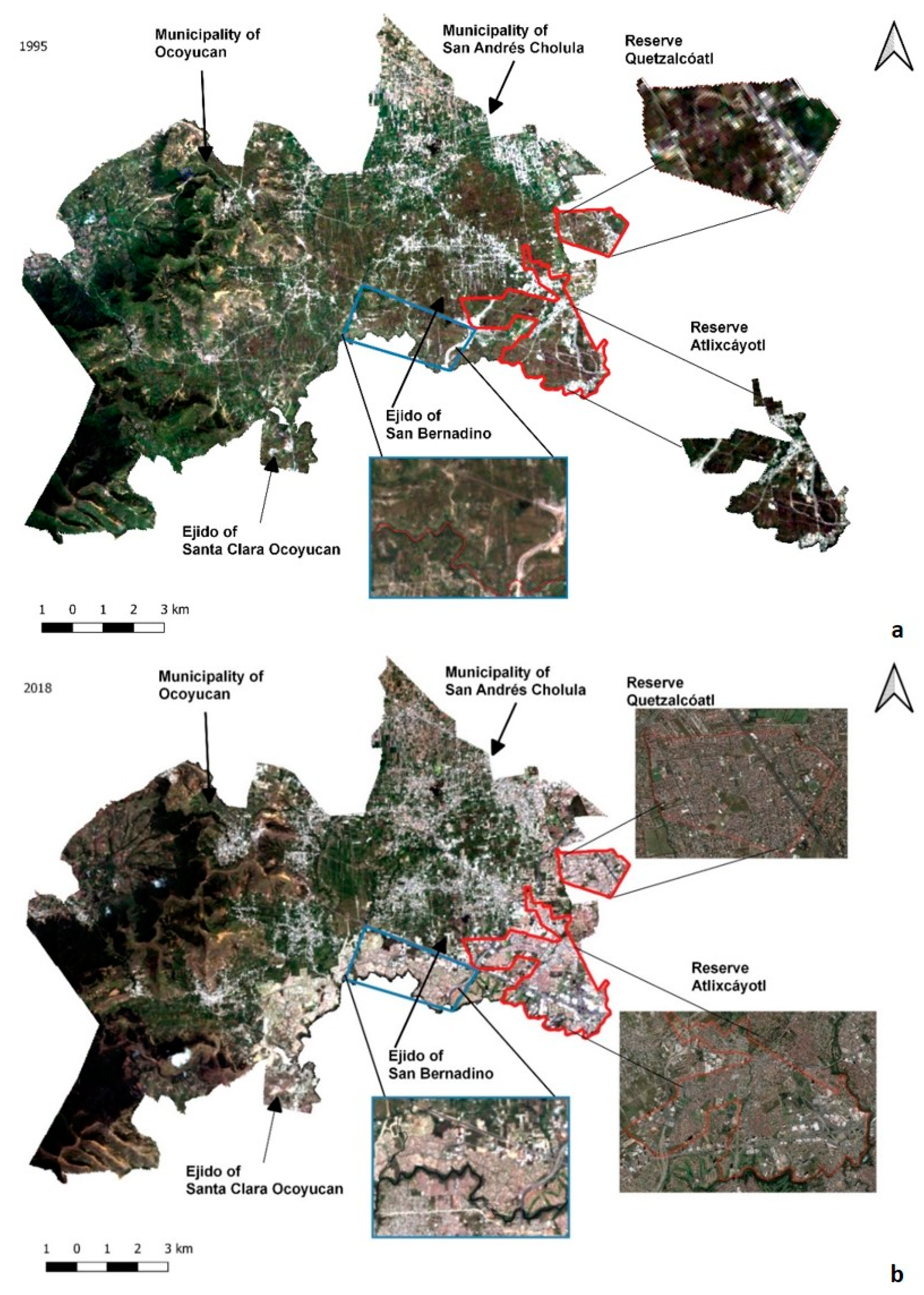
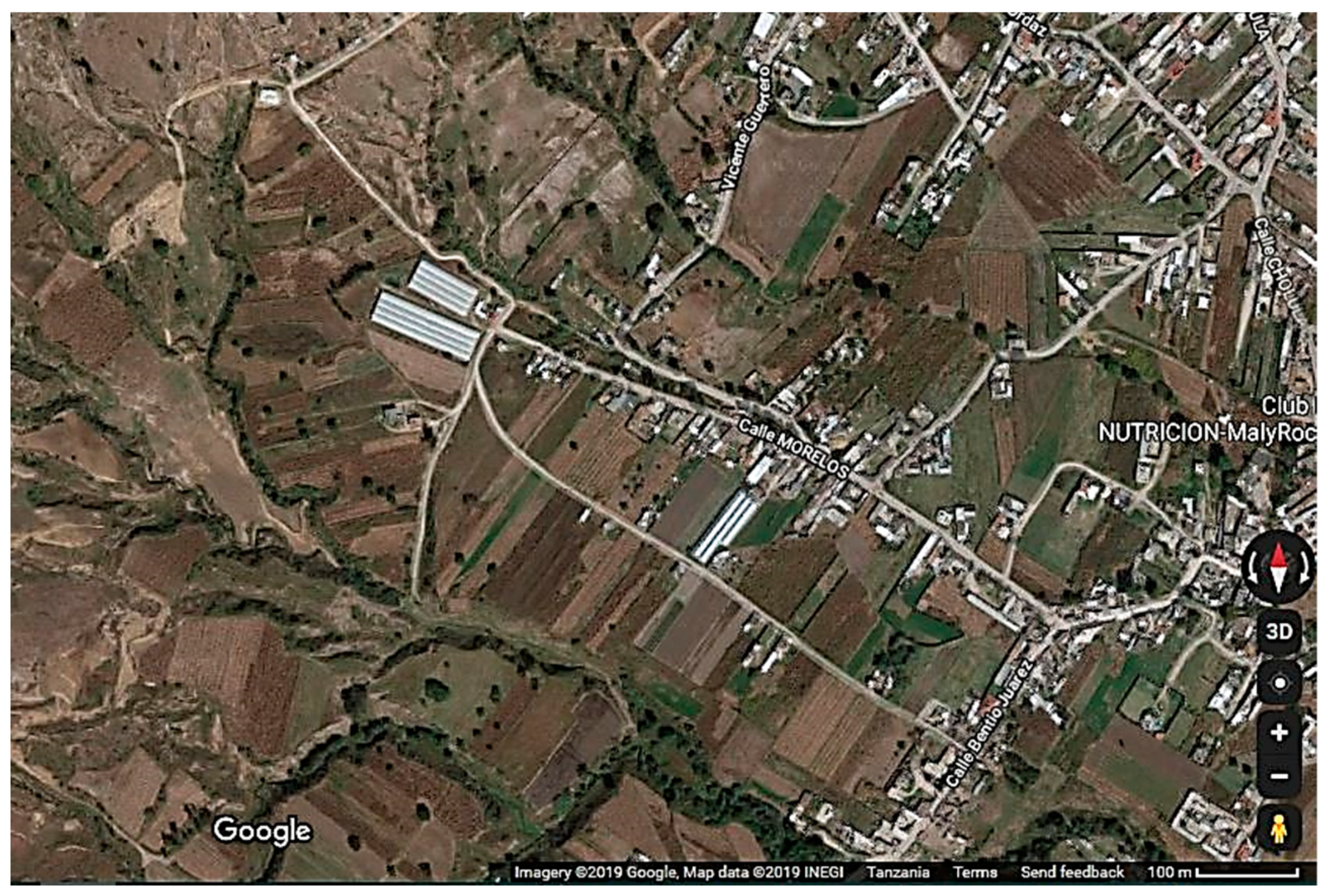
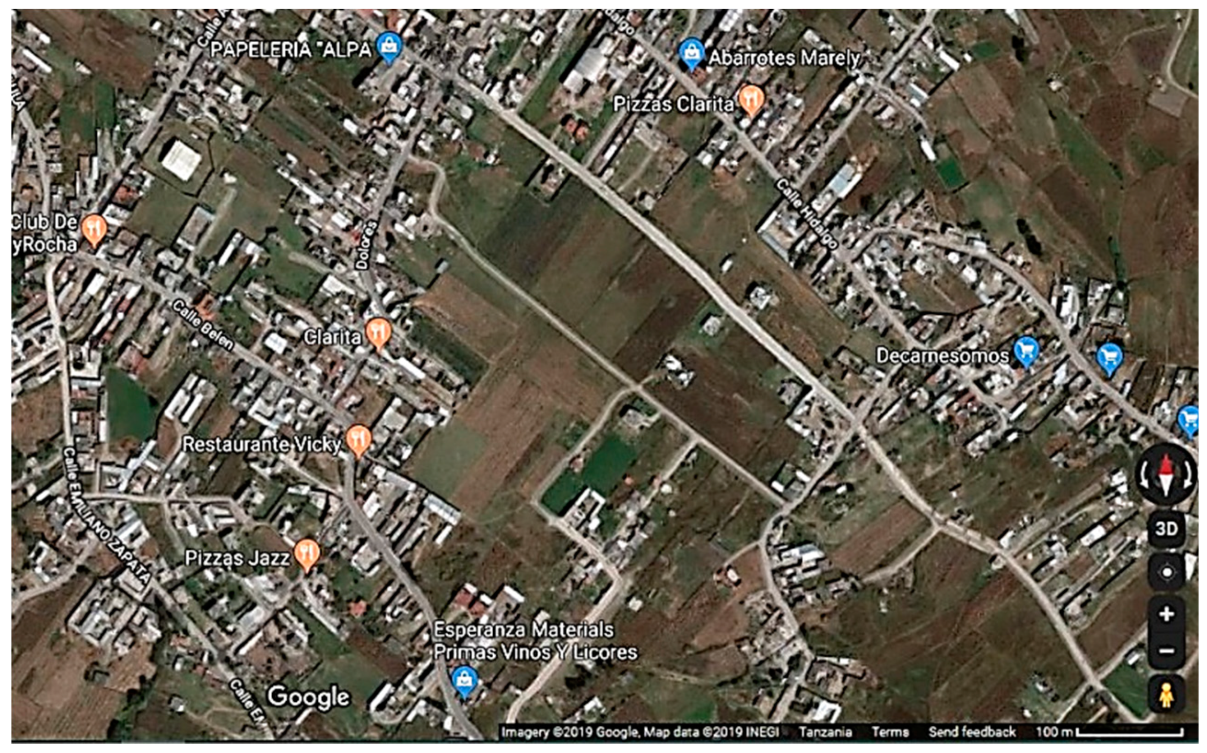
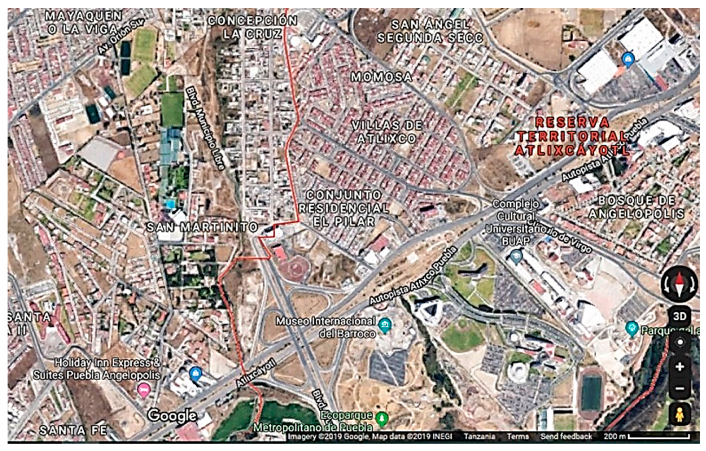
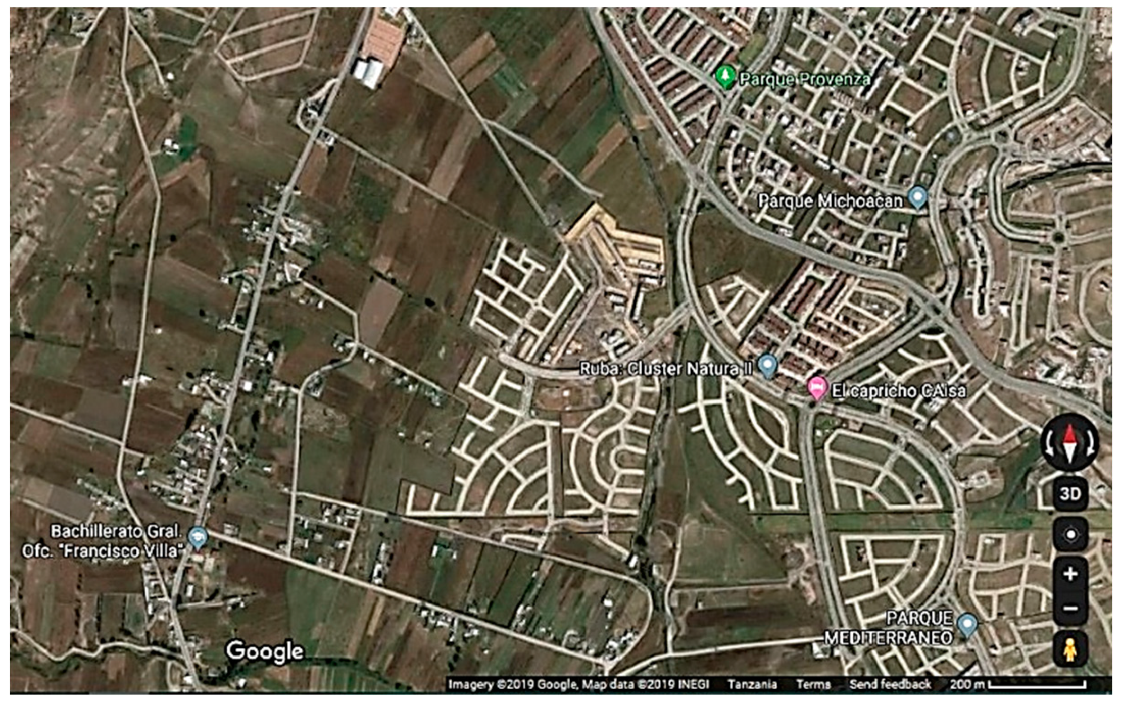
4.2. Geo-Visual Analysis from Satellite Images

How much of the rural territory of San Andrés Cholula and Santa Clara Ocoyucan is now urban? As shown in Table 3, data from INEGI (Instituto Nacional de Estadística y Geografía – National Institute of Statistics and Geography) show the exponential population growth of San Andrés Cholula and Santa Clara Ocoyucan compared to that of other areas, demonstrating that both municipalities are attractive places for new incomers.
In order to visualize the urban growth in the case study areas, we made use of satellite images of the urban settlements. We used images from the satellites Landsat 5 and Landsat 8 from dates corresponding to summers of 1995 and 2018 to measure the urbanization of ejido and rural land and to determine the total area used.
The digital level values of all images were converted to Top of Atmosphere Radiance (TOAR). The use of the Dark Object Subtraction (DOS1) method in QGIS 2.18 was necessary to correct the atmospheric effects. To obtain the total farmed area and urban area per year, as well as its geographical location, we used a supervised classification—the maximum likelihood algorithm of GRASS GIS 7.4—and categorized each of the images into four groups—cultivation area, urban area, soil area and vegetation area.
We applied the method developed by Olofsson et al. [48] to validate the classification and estimation area of each category. The method includes calculating the sample size and assigning it to the coverage type categories based on the best result of five hypothetical assignments. Moreover, to assign the land-use of reference coverage, we performed a visual inspection of each of the sample units using a set of Landsat images together with Google Earth™ images with a difference of 3 months per 2018 image. Google Earth™ 1995 satellite images were available. In accordance with Olofsson et al. [48], after the visual inspection, we calculated the estimation area and error through pixel precision using the confusion matrix relative to the confidence intervals. This procedure was followed for both images from the total study area and for each of the previously determined sub-areas using a confidence interval of 95% and a standard error of 0.015 for the sample size calculation.
Five possible “allocations” were constructed for each year, with an average of 800 samples distributed over four classes per year, based on the confusion matrix suggested by Ofosson et al. As a result, for each class, we obtained the total estimated area and a 95% confidence interval, as described in Table 4 and Figure 3.

5. Results and Discussion

5.1. First Statement—Ejido Land Was and Still Is Potential Privately Developable Land

From 1995 to 2018, how much ejido land from San Andrés Cholula and Santa Clara Ocoyucan was transformed into urban areas? According to Figures 3 and 4 and Table 3 (in Table 4, we recorded 1222 Hectares rather than 1092 because some selected plots correspond to the Atoyac River being used as a boundary for the land reserve), the land uses of the ejidos changed radically over a period of 23 years. The Santa Clara Ocoyucan ejido devoted 41.7% of its territory to farming in 1995 but this had decreased to 25% by 2018. Its urban area, which accounted for only 7.7% of the territory in 1995, increased to 26.3% by 2018 due to the construction of the “Lomas de Angelópolis” gated community.
In 1995, 33% of the Atlixcáyotl-Quetzalcóatl land reserve (shared with San Pedro Cholula and Cuautlancingo municipalities) in San Andrés Cholula was classified as urban and 66% as farmland. In contrast, in 2018, 63% of the land reserve was classified as urban while the remaining 36% of farmland had changed its land use to vacant land for development. In addition, the Atoyac River was the natural border between San Andrés Cholula and the city of Puebla. However, the transfer of 38,100 Hectares of San Andrés Cholula’s land reserve to the city of Puebla in 2014 by the Local Congress [49] changed the territory’s shape and value, as the ceded territory in 2019 is one of the most lucrative and expensive areas in terms of tax and cadastral value [50].
In Figure 2, the Atlixcáyotl-Quetzalcóatl land reserve is shown at the moment of expropriation in 1995 in blue. According to PSDUM, this land reserve shares its boundaries among San Andrés Cholula, San Pedro Cholula, Cuautlancingo and the conurbation with the City of Puebla. The two other main ejidos from San Andrés Cholula and Santa Clara Ocoyucan, the ejido of San Bernardino Tlaxcalancingo and the ejido of Santa Clara Ocoyucan, are delineated in red.
Figure 3 and Figure 4 show the spatial development of the ejidos and rural areas in San Andrés Cholula from 1995 (a) until 2018 (b). It is striking that the land reserve is now almost completely built up and developed. For Santa Clara Ocoyucan, the ejido demarcated in red has been completely urbanized by the “Lomas de Ángelópolis” gated community. In the satellite image, Santa Clara Ocoyucan shows up as a rural municipality with small urban cores; however, this municipality was not part of the PROTA or PSDUM plans but it was progressively urbanized as a crossing municipality to the city of Atlixco.
The ejidos of San Andrés Cholula and Santa Clara Ocoyucan are used as case studies to display planned versus private sector development over former communal land tenure. Additionally, the motorway to Atlixco acts as a route encouraging urban growth, while the natural reserve “Sierra del Tenzo” is the border that prevents gated communities from being conurbated with Atlixco. Despite this, the “Lomas de Angelópolis” gated community is reaching Santa Clara Ocoyucan, as displayed in Figure 3.
The Atoyac River is an urban–rural fringe of the municipality of Puebla, which serves as a natural border at the east of the land reserve and “Lomas de Angelópolis.” As shown in Figure 2 and Figure 3, this border territory became highly dense and the border that corresponds to “Lomas de Angelópolis” has many informal settlements of low-income socioeconomic groups. In contrast, “Lomas de Angelópolis” is an area populated by middle- to higher-income groups.
With the presented data, we may state that most of ejido land can be converted into developable land, especially that in Santa Clara Ocoyucan and its peri-urban communities.

5.2. Second Statement—Land Tenure Changes Benefit Private Developers

When the first expropriations began in 1989 in San Andrés Cholula, the government paid 0.90 Mexican Pesos per m2 of agricultural land. Later on, in 1993–1994, after the protests by the populations of the local rural communities, the price went up to 21.00 Mexican Pesos per m2. The State government then sold the land to private developers to make a profit. Private developers, in turn, were already re-selling the same land extensions as residential lots for 9500 Mexican Pesos (500 US dollars) per m2 [51]. By 2017, the cadastral value of the land occupied by the real estate business in “Lomas de Angelópolis” area had reached a minimum price of 8,044.00 Mexican Pesos per m2 in the commercial zone and 6002.00 Mexican Pesos per m2 in the residential area [52].
Regarding the commercial value, current real estate advertisements reveal that, to date, the best located commercial land in this zone is sold for 19,178.95 Mexican Pesos (1000 US dollars) per m2 and in the residential area, land is sold for 7000.00 Mexican Pesos per m2 to up to 18,000.00 Mexican Pesos per m2 [53]. How have the local communities profited from this increment of land value? They have simply traded their lands and their usufruct for a ridiculously low amount of money while the private sector is profiting from the ejidatarios’ loss. As the economic interests are constantly threatening the coexistence between the rural and urban worlds, socio-economic conflicts have arisen in the border areas between the different cells of the urban “galaxy,” where the threat for more expropriation is latent.
This condition can be observed in the Atlixcáyotl-Quetzalcóatl Land Reserve and in the Santa Clara Ocoyucan municipality. Because of ejido urbanization and land privatization, groups of landowners have imposed ethical, aesthetic, lifestyle and racial limitations inside residential ghettos. Former ejidatarios and peasants are forced to sell their lands, leave their rural communities and abandon agricultural activities to work for new householders and landowners. Those stakeholders are linked to land use change that works according to their interests and needs.
A number of positive and negative aspects are generated when land tenure change is used as an instrument for private development, as summarized in Table 5.

5.3. Third Statement—Spatial Segregation beyond Peri-Urban Morphology

Which types of cities are emerging from the urbanizations of ejidos? As analyzed in former figures, the market pressure is guiding urban sprawl for gated communities through infrastructure. This condition is changing peri-urban morphology due to the imposition of the urban pattern while ejido land is put under real estate pressure. Hence, the process of privatization of ejidos is shaping five different morphologies for urban growth.
In the ejido of Santa Clara Ocoyucan, the rural plots are aligned in a linear grid network perpendicular to water streams, that has adapted to the contour lines of the topography. In ejido tenure, edification in productive farmland is not allowed. As a result, rural settlements tend to follow a PE (according to Solà-Morales, U is for Urbanization, meaning the introduction of urban services, furnaces and infrastructures; P is for Parcelation, denoting the subdivision of the land; and E is for the Edification of buildings) [54] pattern in a linear tree network from a livestock road that delimits the cultivation area of plots and encircles the rhithron of the runoffs. Densification of the rural core follows a corridor cellular pattern in an organic manner, as in type 1 “Organic Pattern” (Figure 5).
Type 1: Organic Pattern
When an ejido is regularized, urban growth reaches it and the former livestock roads transform into urban infrastructures, activating the edification of single-family housing over the farmland plots in a U+P+E pattern, as seen in type 2 “Ribbon Pattern) (Figure 6). As growth by polarization materializes, the plot is densified with further edification of informal single-family houses, typically inhabited by the extended family of the farmer. This marginally urbanized P+E pattern respects the sizes, shapes and orientations of the parcels, although it is not necessarily aligned to the roads; thus, it follows a free corridor matrix within the boundaries of the plots, as in type 3 “Corridor Matrix” (Figure 7).
Type 2: Ribbon Pattern
Type 3: Corridor Matrix
The regularization of ejidos catalyzes a land use change from rural to urban. In cases such as San Andrés Cholula where the ejido land of Atlixcáyotl was part of the land reserve for further urban housing, the extension of infrastructures triggered an ordered grid of urban growth usually radiating from the different highways and ring roads that fracture the territory and overlap with the rural parcels; thus, the edifications tend to be middle-class housing aligned to the parcels and roads in order to occupy most of the surface of the plot. This morphology follows a suburban U+P+E pattern and could either shape an axial lattice or cell strands, depending on the urban clusters and their public spaces, as seen in type 4 “Cluster Zoning” (Figure 8).
Type 4: Cluster Zoning
In the case of Santa Clara Ocoyucan, the urban pressure from the gated community of “Lomas de Angelópolis” coming from the west is evident, as shown by the UP+E urbanization model, with branched cul-de-sac and crescent street types of the garden city outlined over the rural land, regardless of the orientations, sizes or shapes of the rural plots of the original ejidos. As seen in Figure 10, the traced streets of “Lomas de Angelópolis” remain open for further development of ejido land. This pattern is archetypal of private tenure, as seen in type 5 “Gated Community” (Figure 9).
Type 5: Gated community
As illustrated in Figure 10, and based on the results of the case studies, new territorial dynamics are driven by different schemes of land tenure, which means that a strong trend in private urbanization is driving hyper-speculation practices that are leading to the exponential growth of gated communities and urban developments with flexible construction regulations and no local planning.
This leads us to question whether gated communities benefit or jeopardize land management. The logic behind any closed community—regardless of its scale—goes against the principles of a healthy urban fabric. In other words, the mixture of people and land use are threatened by the private sector, which is unconcerned with the socio-spatial effects. Furthermore, this new model implies the arrival of a new urban population and often generates null integration and instead leads to local population dispersal.
The activation of urban growth by the private sector over former ejido land was a trend initiated by flexible local policies, which enabled land privatization and the transformation of agricultural land into urban land. The roles of the public sector and local administrations as key stakeholders in this process are highly questionable. Historically, land tenure was based on obtaining common good for rural communities after the Mexican Revolution but through neoliberal economic reforms, land tenure has become fundamental for economic development and urban growth. These changes caused the loss of good urban–rural public spaces as elements that contribute to the construction of a healthy urban or rural–urban fabric [55], as in our case study areas. If these common public spaces are not considered for new land tenure schemes, territories are condemned to the disappearance of public areas as spaces for community and identity construction. Jeopardizing these features entails the loss of socio-cultural cohesion.

6. Conclusions

Our case study areas, San Andrés Cholula and Santa Clara Ocoyucan, exemplify how traditional ejidos are being developed through different urbanization process yet with analogous results. This means that, although both case studies should have benefited from the liberalization of ejidos in terms of securing land tenure, San Andrés became urbanized through land expropriation and Santa Clara Ocoyucan succumbed to market pressure through urban development driven by the private sector. The consequences for both municipalities were similar: the segregation of peri-urban communities, a rise in land value and weak local policies.
The utilization and choice of the theoretical and analytical framework based on stakeholders as agents of socio-spatial change and a visual geo-analysis of satellite images has proven useful and allowed us to answer to our research questions, as depicted below.
I. How much ejido and rural land has been used for urban development in the case study areas? It has proven difficult to estimate the precise percentage of ejido and rural land that has undergone land use change to favor urban development, as the municipal urban development programs, the Ejidal Census, the National Geo-statistics Institute and PROTA show varying figures. However, the data prove that local urban plans have benefitted infrastructure and zoning development for private developers through tenure change, transforming roughly 60% of San Andrés Cholula’s and up to 100% (which expands to the 16% of the agricultural land beyond ejido tenure) of Santa Clara Ocoyucan’s productive agricultural land into urban area.
II. How does land tenure change shape urban growth in Mexico? Land tenure changes are shaping urban growth in the form of five different urban patterns that replace the rural plots and materialize as cluster zoning and gated communities when private developers are among the stakeholders, as a consequence of market pressure reaching ejidos after land tenure changes.
III. Which model of urbanization has emerged from this? The current urbanization model has its origin in the liberalization and expropriation of ejido land 30 years ago and entails no boundaries between formal and informal peri-urbanization. It responds to private developers’ demands but tends to disregard the needs of ejidatarios, rural landowners and local populations, since cluster zoning and gated communities do not follow the organic array of the land’s biophysical matrix, nor do they consider cultural heritage or available resources—and thus compromise current and future food security. Moreover, the new urbanization model, with the use of gates and fences, prevents the integration of rural and urban lands and limits the access of the native rural population to the newly built urban infrastructures.
This research concludes that stakeholders are both proactive actors of change as well as indirect actors of change. They play a key role, where ejidatarios, investors and local land policies create a new urbanization model ruled by the private sector and market forces, who decide where, how and when land will be developed. Our findings support that the optimization of capital has been a key driver of change and a crucial common element among stakeholders in decisions to approve and accept ejido and rural land for urban conversion. The planning operations carried out by PROTA seem to have contemplated only the participation of the private sector, following an economic developmental logic valid only for investment. However, the excessive participation of the sector has not only led to the extinction of ejidos but has also small rural communities at risk, as they have become isolated in their own territories.
Our recommendation for further research is to study the tools and means to regulate the urbanization of ejido land, considering the following key issues:
IV. Remote sensing: A deeper study of SPOT images with 15 m precision for smaller spaces within the metropolitan areas around the case studies, for a more accurate detection of land uses at edification level is required. Due to the unavailability of digitized geographical information about land tenure changes, we strongly suggest overlapping cadastral and land use maps to the SPOT images in order to appreciate the land tenure changes in regular and informal settlements. This procedure would allow the spatial visualization and accurate quantification of the extension of ejido land that has been urbanized after privatization.
V. Transparency and land governance: Based on the challenges we faced while gathering reliable data for this study, attributable to the data inconsistencies between the municipal development plans, the municipal programs for urban sustainable development, INEGI Ejidal Census and the National Agrarian Registry, it is necessary to set the basis for the normalization of geographical data and cadastral maps among the different local, regional and national institutions to enable a better access to more consistent information. This initiative would support the transparency on the formulation, implementation and enforcement of land policies and on tracing responsible land management strategies.
VI. Stakeholders’ accountability: Grounded on López-Tamayo and Harvey’s understanding that stakeholders are agents of socio-spatial change, we suggest a participatory planning approach on ejido interventions which should involve active stakeholders and members of the local ejidal community. Considering the New Urban Agenda from Habitat III [56] and the Principles for Responsible Investment in Agriculture and Food Systems (CFS-RAI) [57] would form a suitable environment of responsible investment on ejido land. With these guidelines in mind, the policies, laws, regulations and institutional framework should establish a strategy for socio-economic development that legitimizes ejidatarios’ tenure rights. Identifying the roles and accountability of the different stakeholders is fundamental for creating an enabling environment with changes that benefit the community.
The urban development promoted by public policies should privilege the improvement of current socio-economic conditions of the local population through long term strategies focused on economically and environmentally sustainable land use, renovated agricultural production practices, egalitarian urbanization considering bottom-up planning strategies and legal regulations protecting communities from external commercial and economic pressures. The public policy should thus develop new prosperity models for ejido land instead of regarding it as a potential source for fast economic benefits reached through expropriations and other state-directed maneuvers that promote excluding urbanization processes.

Author Contributions

Conceptualization, M.S. and P.D.-D.; methodology, M.S. and D.A.G.-R.; validation, D.A.G.-R.; formal analysis, P.D.-D. and A.K.K.; investigation, M.S., P.D.-D. and E.G.-J.; resources, E.G.-J.; data curation, E.G.-J.; writing—original draft preparation, M.S. and P.D.-D.; writing—review and editing, M.S. and P.D.-D.; visualization, D.A.G.-R.; supervision, A.K.K.; funding acquisition, M.S. and P.D.-D.

Funding

This work was supported by the Science and Technology Council of State of Puebla (CONCYTEP), the German Research Foundation (DFG) and the Technical University of Munich (TUM) in the framework of the Open Access Publishing Program.

Acknowledgments

The authors would like to thank Teodoro Schumacher, Nicolás López Tamayo for their knowledge regarding ejido history and the current situation of the rural world in Mexico. We would also like to express our gratitude to Walter Timo de Vries, Karl Hughes and the MDPI English editing service for their comments and suggestions when proofreading this paper.

Conflicts of Interest

The authors declare no conflict of interest.

References

  1. Appendini, K., II. La transformación de la vida rural en tres ejidos del centro de México (II. The transformation of rural life in three ejidos in central Mexico). Rural. Sin Agric. 2008, 27–58. [Google Scholar]
  2. Simpson, E.N. The Ejido: Mexico’s Way Out. Ph.D. Thesis, The University of North Carolina, hapel Hill, NC, USA, 1937. [Google Scholar]
  3. Warman, A. El Campo Mexicano en el Siglo; Fondo de Cultura Ecónomica: Mexico City, Mexico, 2001. [Google Scholar]
  4. Karst, K.L.; Clement, N.C. Legal institutions and development: Lessons from the Mexican Ejido. Ucla L. Rev. 1968, 16, 281. [Google Scholar]
  5. Singelmann, P. Rural collectivization and dependent capitalism: The Mexican collective Ejido. Lat. Am. Perspect. 1978, 5, 38–61. [Google Scholar] [CrossRef]
  6. Cord, L.; Wodon, Q. Do agricultural programs in Mexico alleviate poverty? Evidence from the ejido sector. Cuad. Econ. 2001, 38, 239–256. [Google Scholar] [CrossRef]
  7. Torres-Mazuera, G. La territorialidad rural mexicana en un contexto de descentralización y competencia electoral. Rev. Mex. Sociol. 2009, 71, 453–490. [Google Scholar]
  8. Torres-Mazuera, G. Transformación identitaria en un ejido rural del Centro de México. Reflexiones en torno a los cambios culturales en el nuevo contexto rural. Rural. sin Agric. 2008, 239–255. [Google Scholar]
  9. Méndez-Lemus, Y.; Vieyra, A.; Poncela, L. Periurbanization, Agricultural Livelihoods and Ejidatarios Social Capital: Lessons from a Periphery Municipality in Michoacán, Mexico. Procedia Eng. 2017, 198, 428–443. [Google Scholar] [CrossRef]
  10. Jones, G.A.; Ward, P.M. Privatizing the commons: reforming the ejido and urban development in Mexico. Int. J. Urban Reg. Res. 1998, 22, 76–93. [Google Scholar] [CrossRef]
  11. Olivera, G. La Urbanización Social y Privada del Ejido. Ensayos Sobre la Dualidad del Desarrollo Urbano en México; Universidad Nacional Autónoma de México: Mexico City, Mexico, 2015. [Google Scholar]
  12. Iracheta, A.X. Acceso a terrenos con servicios para los pobres urbanos: la paradoja de la regularización en México. Econ. Soc. Y Territ. 2000, II, 754–789. [Google Scholar] [CrossRef]
  13. Alarcón, A.R. La organización ejidal en el desarrollo rural de México. Estud. Agrar. 2015, 59, 181–204. [Google Scholar]
  14. Stanford, L. The privatization of Mexico’s ejidal sector: Examining local impacts, strategies and ideologies. Urban Anthropol. Stud. Cult. Syst. World Econ. Dev. 1994, 23, 97–119. [Google Scholar]
  15. De Grammont, H.C. El campo mexicano a finales del siglo XX (The Mexican Countryside in the Late 20th Century). Rev. Mex. Sociol. 2001, 81–108. [Google Scholar] [CrossRef]
  16. Morett-Sánchez, J.C.; Cosío-Ruiz, C. Panorama de los ejidos y comunidades agrarias en México. Agric. Soc. y Desarro. 2017, 14, 125–152. [Google Scholar] [CrossRef]
  17. Warman, A. Mexican land reform: a long-term perspective. L. Reform L. Settl. Coop. 2003, 84, 95. [Google Scholar]
  18. Schumacher, M. Peri-urban development in Cholula, Mexico: towards a socio-spatial management model. Ph.D. Thesis, Technische Universität München, München, Germany, 2016. [Google Scholar]
  19. Barnes, G. The evolution and resilience of community-based land tenure in rural Mexico. Land Use Policy 2009, 26, 393–400. [Google Scholar] [CrossRef]
  20. Vázquez, C.G. Teorías e Historia de la Ciudad Contemporánea; Editorial Gustavo Gili: Barcelona, Spain, 2016. [Google Scholar]
  21. Font, A. L’explosió de la Ciutat: Transformacions Territorials Recents en les Regions Urbanes de l’Europa Meridional; Col-legi d’Arquitectes Catalunya: Barcelona, Spain, 2004. [Google Scholar]
  22. Lefebvre, H. The production of Space (1991). In The People, Place and Space Reader, 1st ed.; Jack Gieseking, S.S., Mangold, W., Katz, C., Low, S., Eds.; Routledge: London, UK, 2014. [Google Scholar]
  23. The World Bank. “Stakeholder Analysis,” What is Stakeholder Analysis? 2001. Available online: http://www1.worldbank.org/publicsector/anticorrupt/PoliticalEconomy/stakeholderanalysis.htm. (accessed on 13 August 2019).
  24. Schmeer, K. Guidelines for Conducting a Stakeholder Analysis. 1999: Bethesda, USA. Available online: https://www.who.int/management/partnerships/overall/GuidelinesConductingStakeholderAnalysis.pdf (accessed on 21 July 2019).
  25. Pírez, P. Actores sociales y gestión de la ciudad. Rev. Ciudad. 1995, 28, 8–14. [Google Scholar]
  26. López-Tamayo, N.E. a Urbanización Periférica mercado de suelo urbanización popular en la Ciudad de Puebla entre 1970 y 1990. Ph.D. Thesis, UNAM, Mexico City, Mexico, 1995. [Google Scholar]
  27. Harvey, D. Rebel Cities:From the Right to the City to the Urban Revolution; Verso: London, UK, 2012. [Google Scholar]
  28. Wilkie, J.W.; Hammond, M. Primera Reforma Agraria en México, 1853-1909, a través de la estadística nacional. Mex. World. 1998, Volume 3. Available online: http://www.profmex.org/mexicoandtheworld/volume3/3summer98/laestadistica_economicap2.html (accessed on 21 July 2019).
  29. Katz, F. La Guerra Secreta en México; Ediciones ERA: Mexico City, Mexico, 1982. [Google Scholar]
  30. Assennatto Blanco, P.; de Leon Mojarro, S. La democracia interna en el ejido. Estud. Agrar. 1996, 2, 117–132. [Google Scholar]
  31. De Diputados, C. Ley Agraria. H. Congreso de la Unión. 2017. Available online: http://www.diputados.gob.mx/LeyesBiblio/pdf/13_250618.pdf. (accessed on 18 July 2019).
  32. Robles, H.M. Tipología de los sujetos agrarios Procede. Estud. Agrar. 1996, 4, 11–39. [Google Scholar]
  33. Ake, C.; Flores, M.J.D.F. Análisis de la privatización de la tierra de régimen social en México. (Bachelor thesis); Universidad Autónoma Agraria Antonio Narro: Saltillo, Mexico, 2007; Available online: http://repositorio.uaaan.mx:8080/xmlui/bitstream/handle/123456789/920/T16538%20COLLI%20%20AKE%2C%20JUAN%20GABRIEL%20%20MON.pdf?sequence=1&isAllowed=y (accessed on 21 July 2019).
  34. Perramond, E.P. The rise, fall and reconfiguration of the Mexican ejido. Geogr. Rev. 2008, 98, 356–371. [Google Scholar] [CrossRef]
  35. Verea, M. Immigration trends after 20 years of NAFTA. Norteamérica 2014, 9, 109–143. [Google Scholar] [CrossRef]
  36. Riveros, L. La incorporación de terrenos ejidales y comunales al desarrollo urbano. México Procur. Agrar. 2000, 9, 87–124. [Google Scholar]
  37. Haenn, N. The changing and enduring ejido: a state and regional examination of Mexico’s land tenure counter-reforms. Land Use Policy 2006, 23, 136–146. [Google Scholar] [CrossRef]
  38. De la Federación, D.O. Solicitud de expropiación de terrenos pertenecientes al ejido Santiago Momoxpan de San Pedro Cholula, antes Cholula, Pue. Diario Oficial de la Federación. Available online: http://www.dof.gob.mx/nota_detalle.php?codigo=4646595&fecha=27/01/1992. (accessed on 26 March 2019).
  39. De la Federación, D.O. Decreto por el que se expropia por causa de utilidad pública una superficie de terrenos de temporal de uso común del poblado San Bernardino Tlaxcalancingo, Municipio de San Andrés Cholula, Pue,” Diario Oficial de la Federación. Available online: http://dof.gob.mx/nota_detalle.php?codigo=4664172&fecha=04/05/1992. (accessed on 26 March 2019).
  40. Aguirre, A.M. Megaproyecto de Salinas y Bartlett; Proceso: Mexico City, Mexico, 1993; Available online: https://www.proceso.com.mx/162157/megaproyecto-de-salinas-y-bartlett (accessed on 21 July 2019).
  41. Secretaría de Finanzas y Administración. Actualización del Programa Regional de Desarrollo, Región Angelópolis 2011–2017; Gobierno del Estado de Puebla: Puebla, Mexico, 2011. [Google Scholar]
  42. Programa Regional de Ordenamiento Territorial Angelópolis; Puebla: Mexico City, Mexico, 1993.
  43. Agbel, C.E. Programa Municipal de Desarrollo urbano Sustentable de San Andrés Cholula 2014-2018; Ayuntamiento de San Andrés Cholula: San Andrés Cholula, Mexico, 2018. [Google Scholar]
  44. INEGI. Actualización del marco censal agropecuario 2016. Available online: www.inegi.gob.mx (accessed on 10 May 2019).
  45. CONAPO. Delimitación de las zonas metropolitanas de México 2015, 2018th ed.; SEGOB, SEDATU, CONAPO: Mexico City, Mexico, 2018. [Google Scholar]
  46. INEGI. Encuesta Intercensal 2015; INEGI México: Mexico City, Mexico, 2015. [Google Scholar]
  47. INEGI. Puebla Resultados Definitivos VII Censo Ejidal; INEGI: Mexico City, Mexico, 1994. [Google Scholar]
  48. Olofsson, P.; Foody, G.M.; Herold, S.V.; Stehman, C.E.; Woodcock; Wulder, M.A. Good practices for estimating area and assessing accuracy of land change. Remote Sens. Environ. 2014, 148, 42–57. [Google Scholar] [CrossRef]
  49. Hernández, G. Define congreso límites entre municipios de Puebla y Cholula. Proceso, 6 December 2018. [Google Scholar]
  50. Ruiz, L. Crece 813 pesos valor catastral de Angelópolis y Atlixcáyotl. E-Consulta, Puebla. 2018. Available online: https://www.e-consulta.com/nota/2018-12-12/economia/crece-813-pesos-valor-catastral-de-angelopolis-y-atlixcayotl (accessed on 10 may 2019).
  51. Santos, P.V. Por la Buena o Por la mala’ El Estado y la Lucha por la Tierra en Santa Maria Tonantzintla, Puebla. Una Historia Ejidal (Bachelor thesis) Universidad de las Américas Puebla. 2005: Cholula, Mexico. Available online: http://catarina.udlap.mx/u_dl_a/tales/documentos/laac/velasco_s_p/ (accessed on 14 June 2019).
  52. Zonificación Catastral, Tablas de Valores Unitarios de Suelos y Valores Catastrales de Construcción de Puebla; Gobierno del Estado de Puebla, Secretaría General de Gobierno: Puebla, Mexico, 2017.
  53. Terrenos en Venta en Reserva Territorial Atlixcáyotl, San Andrés Cholula. 2019. Available online: https://www.inmuebles24.com/terrenos-en-venta-en-reserva-territorial-atlixcayotl.html (accessed on 23 July 2019).
  54. Solà Morales Rubio, M. Las Formas de Crecimiento Urbano; Universitat Politècnica de Catalunya: Barcelona, Spain, 1997. [Google Scholar]
  55. Borja, J.; Muxí, Z. El espacio Público: Ciudad y Ciudadanía; Electa Editores: Barcelona, Spain, 2003. [Google Scholar]
  56. United Nations. New Urban Agenda; United Nations: New York City, NY, USA, 2017. [Google Scholar]
  57. Committee on World food Security. Principles for responsible investment in Agriculture and Food Systems; Committee on World food Security: Rome, Italy, 2014. [Google Scholar]
Figure 1. Locations of the case study areas in Mexico.
Land 08 00146 g001
Figure 2. Distribution of Ejidos in San Andrés Cholula and Santa Clara Ocoyucan.
Land 08 00146 g002
Figure 3. Land use classification data in (a) 1995 and (b) 2018.
Land 08 00146 g003
Figure 4. Spatial development in (a) 1995 and (b) 2018.
Land 08 00146 g004
Figure 5. Ejido of Santa Clara Ocoyucan. Source: Google Maps (accessed on 23 July 2019). Land use: Rural–farming land; Tenure System: communal land/ejido; Stakeholders: Ejidatarios.
Land 08 00146 g005
Figure 6. Built Ejido land in Santa Clara Ocoyucan. Source: Google Maps (accessed 23 July 2019). Land use: Rural–farming land; Tenure System: Communal land/ejido; Stakeholders: Ejidatarios, Rural population, Local authorities.
Land 08 00146 g006
Figure 7. Informal housing in Ejido in Santa Clara Ocoyucan. Source: Google Maps (accessed 23 July 2019). Land use: Rural–informal; Tenure System: Regularized ejido; Stakeholders: Ejidatarios, Landowners, Local authorities, Regularization agency (Institute for Sustainable Land).
Land 08 00146 g007
Figure 8. Middle class housing in Atlixcáyotl. Source: Google Maps (accessed 23 July 2019). Land use: Urban, commercial services, Middle-class and social housing; Tenure System: Expropriated ejido for urban development; Stakeholders: Ejidatarios, Regional authorities, Regularization agency (Institute for Sustainable Land), Private developers.
Land 08 00146 g008
Figure 9. ¨Lomas de Angelópolis¨ Engulfing Santa Clara Ocoyucan. Source: Google Maps (accessed 23 July 2019). Land use: Gated community; Tenure System: Regularized ejido transformed into individual private ownership; Stakeholders: Ejidatarios, Landowners, Regularization agency (Institute for Sustainable Land), Private developers.
Land 08 00146 g009
Figure 10. Segregation and urbanization model of former Ejido land. Source: Melissa Schumacher (2019).
Land 08 00146 g010
Table 1. Agrarian Change in Mexico. Source: Melissa Schumacher and Teodoro Schumacher.
Agrarian System FeaturesHacienda System 19th CenturyAgrarian Reform 20th CenturyPost-NAFTA 21th Century
Land tenureLarge estatesEjido, land distribution policiesPrivate ownership and urbanization of communal and ejido land
Ancestral communal landSmall private properties
Population concentrated in small villages and townsRestrictions from ejidos regarding the open-land market
CapitalAgro-industrial productionPublic capital, subsidy policies to ejidos, public loansSubsidies to the agrarian sector
Landlord investmentProtection of the National marketInternational and private investment for the agrarian industry
Rise and fall of agrarian productivityImportation of corn, grains and agricultural commodities from the USA and other countries
International exportation of agricultural commoditiesBeginning of the importation of grains and goods from the USA
LaborCheap farming and peasant labor for HaciendasSelf-consumption and individual productionAgro-industrial production, self-production
“Wage slavery” systemRural–urban migrationRural labor migration to the USA
Abandonment of agricultural activities in Mexico
TechnologyHacienda’s technology for agro-industrializationFree distribution of farm equipment, livestock and farm goods to ejidatarios by subsidiesPrivate development for agro-companies
Technical training from the State to the ejidatariosDistribution of farm goods from the State to small farmers
Subsidies through rural and agricultural development projects
OrganizationLandlords controlled the economy, commerce, transportation and labor structure.Rural collectivesRural–local collectives, small producers, the association of small producers and rural cooperatives with big agro-industries
Family labor organization inside and outside the ejidos for survival“Employees in their own land” through a Neo-Latifundium system based on private investment and development. Peasants and farmers produce for big companies
Ejidatarios’ labor unions
NAFTA abbreviation stands for the North America Free Trade Agreement signed between Mexico, the United States and Canada in 1994.
Table 2. Population Growth and density. Source: INEGI (2010, 2015), CONAPO (2018).
Municipality1990200020102015DENSITY
San Andrés Cholula (77.182 km2)37,78856,066100,439137,2902171.7 pop/km2
Pop. Growth2.5%5.8%7%
Santa Clara Ocoyucan (120.165 km2)17,70823,61925,72028,220214 pop/km2
Pop. Growth2.9%0.8%2.0%
Puebla (Capital) (548.889 km2)1,057,4541,346,9161,539,8191,576,2592805.34 pop/km2
Pop. Growth2.5%1.3%0.6%
Metropolitan Area of Puebla-Tlaxcala (2394.4 km2)1,776,8842,269,9952,728,7902,941,98976.6 pop/Ha
Pop. Growth2.5%1.8%1.6%
Table 3. Names and sizes of Ejidos in San Andrés Cholula and Santa Clara Ocoyucan. Source: VII Ejidal Census.
Municipality and Ejidos before 1995Total Hectares of Ejidos in 1995Urban Development after 1995Total Hectares of Ejidos Transformed into Urban Areas From 1995 to 2018
SAN ANDRÉS CHOLULA
Ejido San Andrés Cholula1986.00Land Reserve Atlixcáyotl—PSDMU1222.00
Ejido San Bernardino TlaxcalancingoSeveral gated communities, high-towers and retail areas
SANTA CLARA OCOYUCAN
Ejido Emilio Portes Gil3614.50Lomas de Angelópolis (gated community developed by Grupo Proyecta)4204.00
Table 4. Sampling Size calculation for the case study areas according to Olofsson’s method. Source: David A. Gonzáles-Rivas (2019).
Ejido Santa Clara Ocoyucan
STRATAHectaresLand use development 95% confidence interval95% confidence interval
Cultivation area
1995666541.70% (Overall Average)562 Hectares8%
2018401225%2556%
Urban
199512307.7%20316%
2018420426.30%3438%
Soil (vacant)
1995175611%23413%
201810326.5%26426%
Vegetation
1995633639.63%5639%
2018673942.20%3836%
TOTAL15,987100%
Atlixcáyotl-Quetzalcóatl Land Reserve
STRATAHectaresLand use development95% confidence interval95% confidence interval
Cultivation area
199581166% (Overall Average)31 Hectares4%
2018 (Vacant Land)44736%4610%
Urban
199541033%317%
201877563%466%
Total1222100%
Table 5. Positive and negative aspects of the urbanization of Ejidos in the case study areas. Source: Melissa Schumacher (2019).
Key Aspects and StakeholdersSan Andrés CholulaSanta Clara Ocoyucan
Positive aspectsNegative aspectsPositive aspectsNegative aspects
PSDMU (urban plan) → Local authoritiesPlan that managed urban growthDid not consider local needsNew urban land uses for tax collection.Urban plan made to benefit urban developers and urban sprawl beyond land reserve
Regulations were updated according to private needs.
Private master plans → Private investorsNational investmentLand use change to benefit land speculationLocal and National investment in infrastructure and housingConstruction of gated communities and luxury buildings that isolate local communities
Cadastral and market values → Local authorities and real estate developersHigher market value, more taxationSpeculation with land market valueAdded value through land use changeCheap ejido and rural land in the borders
Rural communities → Ejidatarios and land ownersAdded value to landExpropriation, migration to the USA and abandonment of agricultural activitiesAdded value to landLand speculation and intimidation by developers Abandonment of agricultural activities
Socio-spatial segregationSocio-spatial segregation
New incomers → New inhabitants and local populationModern areas to live and work in with private securityVery expensive area to buy or live inResidential areas with new houses, parks, schools, leisure and entertainment areas with private securityNot integrated with local communities

