1. Introduction
Rural areas are recognized for having a wide range of groups with different interests that claim land rights, and also for their complexity and multi-functional capacities [
1]. The environmental protection of these spaces imposes restrictions associated with the use of resources and toughens the regulation of decision-making processes. These two problems: Use and decision restrictions make the planning of protected rural areas complex [
2]. Restrictions on the use of natural resources have traditionally been a source of conflict between different stakeholders with land interests. On the other hand, the conflicts associated with the management of the territory are aggravated by the excessive regulation and the complexity of decision-making processes, in which external agents generally intervene and the interests of local communities are not considered.
The problem of imposed restrictions on land use is grounded in the common dilemma theory [
3], which holds that human beings are unable to manage non-market resources efficiently and the inevitable result is the depletion of natural resources until exhaustion. This idea underlies the restrictions associated with the regulation of protected spaces. However, some studies have shown that an adequate incentive structure would solve this problem in addition to demonstrating that local communities are the most interested in guaranteeing the sustainability and conservation of natural resources since they represent their main sustenance, and what is more, under conditions of good government, they are capable of organizing themselves efficiently so as to sustainably manage the territory [
4]. In fact, in many cases, local communities themselves have taken the initiative to improve the sustainability of farms [
5]. In any case, said incentive structures seem to work when there exist minimum conditions of governance in which all the stakeholders with interests in the land participate in the decision-making process [
6]; however, when these conditions are not met, then arises the problem of restrictions on the decisions associated with the protection of rural spaces.
The structure of governance in rural areas is complex since the rural milieu is characterized by the presence of a great variety of collective stakeholders whose activities respond to different logical decisions, thus occupying different positions in the system of governance [
7]. In this way, it is not possible to analyze all the agents involved in the rural milieu as a homogeneous whole. In protected areas, decision-making processes are often controversial, as decisions are generally made by institutional stakeholders without considering the preferences of other local stakeholders closely linked to the land. Institutional stakeholders have not got an associative reference to generate a strong local relationship network, given that some of these stakeholders are in the area as the consequence of the implementation of rural development policies. In the academic literature it is possible to find several examples of research on decision-making applied to the use of resources in natural spaces [
8,
9,
10,
11].
In any case, the presence of an institutional network in the rural environment is fundamental but it is also important to ensure adequate synergy between the different types of institutions as well as between them and the other local stakeholders so as to create conditions of good governance that allow for an efficient organization of local communities for the sustainability of the rural environment [
12]. In this regard, there is an increasing concern to improve participatory processes in protected areas. Specifically, most conflicts have traditionally been generated by decision-making problems related to the use and management of natural resources, and for this reason, a greater effort has been devoted to the implementation of different participatory processes seeking to resolve them [
2]. There is a large number of methodologies that integrate individual preferences but, in order to ensure the full participation of all stakeholders, it is important that such methodologies are simple to comprehend and apply.
The objective of this paper is twofold: To show the usefulness of a simple participatory method to identify priorities in the management of a protected rural area by considering the preferences of stakeholders and to provide a tool to identify conflicts. This paper makes use of a voting method based on the Borda count to determine the priorities of stakeholders with respect to the management objectives of a Spanish-Portuguese protected rural area. Once the priorities were determined, the changes in their ranking in terms of land management were analyzed when introducing the preferences of rural landowners into the analysis, which are currently not taken into consideration. Finally, inter-group conflicts were identified.
2. Background and Hypothesis
It is possible to find two main lines of research in the literature on rural development: One related to the activities that can be feasible and contribute to the development of rural areas and, secondly, the line related to the ability of these activities to promote such development in a truly sustainable way [
13]. The measures adopted with the aim of improving development in rural areas must include aspects related to life, work, housing, leisure, or communications; therefore, a global approach based on the territory rather than a sector-specific approach is required [
14]. The planning processes aimed at rural development and the creation of lines of cooperation do not only require financial support, but also other key aspects such as organizational structures, management processes, processes of participation, and decision-making processes [
14]. These elements are key to preserving the rural nature of the areas under planning, as the impacts derived from new activities can alter the environment and, thus, local lifestyles [
15]. Achieving attractive living conditions in rural areas will depend on the constant adaptation of planning tools to new challenges, regional cooperation in municipal networks, the early and community development of local strategies, and the creation of on-going debates about lifestyle and values in relation to public services in rural contexts [
16]. In this context, the concept of ruralization gains protagonism and importance [
17].
This comprehensive approach to planning rural development leads us to consider integrated rural development (IRD) models. The literature on these models is certainly recent [
18]. These models refer to the need of coordinating sector-based actions with the purpose of improving the level of development of a territory [
19]. Many authors have pointed out that in order for policies to satisfy a variety of needs, a mobilization of local stakeholders supported by cooperation structures and agreements must be carried out [
18]. In the mid-1980s, these models began to take center stage to the detriment of sector-specific models, following the momentum gained in 1982 when the European Economic Community EEC launched its first IRD in certain rural regions. Since 1989, EEC Regional Development Funds have been conceived with the objective of improving development in rural regions by means of an integrated approach that involves different sectors and levels of government [
20]. Such funds are managed according to a mechanism in which different stakeholders point out environmental problems and propose a strategy in a single document, which shows a clear example of cooperation and definition of priorities. The LEADER model is a good example, given that its objective is to diversify production, increase competitiveness, and maximize human resources through increasing the power of local communities [
21] with the creation of Local Action Groups (LAGs). LAGs are organizations consisting of local councils, cooperatives, entrepreneur groups, associations, and local self-employed individuals [
22]. These organizations implement the local development strategy by designing and enforcing strategies financed by the LEADER framework [
23]. The LEADER model not only proposes a more advanced vision with respect to sector-based policies, but also has an impact on endogenous development policies as a means of boosting the opportunities of rural citizens, so that they can better withstand global competition, economic or social crises, and exclusion [
24,
25,
26].
However, these planning systems are not concerned with which methodologies should support decision-making and conflict management, even though it is obvious that such problems will arise. In line with the example provided by EU policy, there are areas in which the conflict in the definition of territorial policy objectives is still present. This is the case of the Common Agricultural Policy, where attempts to reform this mechanism have led it to evolve from a sector-based approach to one based on IRD [
27]. In this context, the concept of rural development has become a battleground for the symbolic and factual struggle between agricultural and other types of interests.
New approaches to rural development have challenged the concepts of government and governance. Models based on IRD try to coordinate the different stakeholders involved in decision-making at a municipal level. Governance, on the other hand, “refers to the development of forms of government in which the boundaries between the public and private sectors have become blurred” [
28] (p. 2). Governance therefore entails a greater role for both public and private partnerships in decision-making. According to Goodwin [
29] (p. 2), the increasing use of this term “suggests a significant change in the processes that govern rural society and implement rural policies”. In this new model, the state assumes the role of coordinator or, even, facilitator of decision-making and agreement processes, but it also takes on the role of fostering cooperation networks and involving new stakeholders, which could in a way be considered a form of “governing via the community” or “remote government”. Cheshire [
30] (p. 144) points out some negative points of these participatory governance processes, as they tend to send “simultaneously embeded rural people into a state of subjection to the vagaries of the market”. But it also points out that, in this way, citizens retain some power over the agenda of priorities. These systems can be seen as an opportunity for participation and empowerment [
18], even though they might be understood as a delegation of the responsibilities of the public sector. Thus, a tension exists between the concern to promote local participation in development strategies and the confidence in a set of management techniques such as targeting, auditing, and financial control, which are deployed to ensure that local institutions are accountable to (central) government [
31]. Important questions arise in this debate about the effectiveness of these new forms of government. For instance, who should be involved, who should not be involved, and the justification for such matters [
32]. In this sense, it has traditionally been considered that the participation of local populations in decision-making regarding natural resources could be detrimental to their conservation. This theory is based on the tragedy of the commons [
3] and is supported by some studies [
33,
34]. Nonetheless, other studies argue that local communities are able to organize themselves to manage said resources efficiently and sustainably if certain conditions of good governance are met [
4,
6,
35,
36].
From the perspective of spatial planning systems, there is often a plea for integrating and uniting several public and private initiatives [
37]. The process of spatial planning, as a consequence of the expansion of new forms of government, has been questioned and renovated, which undoubtedly acquires great relevance when it comes to rural development [
18]. The key ingredient here is the conformation of places. The conformation of places can be understood as “self-conscious collective efforts to reimagine a city, urban region or larger territory and transform the result into investment priorities in the area, conservation measures, investments in strategic infrastructure and land use regulation policies” [
38] (p. 46). However, as this same author points out, in the context of the new governance models, territorial planning processes must be re-invented by considering deliberative processes and collective actions as models, as these systems are far removed from traditional practices based on centralized models. Other authors have criticized this orientation that reinforces democratic processes by deeming it too idealistic or utopian [
39], or even by linking it to power struggles among stakeholders and generating conflicts per se [
40]. Certainly, it is necessary to be realistic about the unequal relationships of power involved and to guarantee adequate decision-making mechanisms that are objective and include systems for managing conflicts.
The concept of Biosphere Reserve protection, created by UNESCO’s Man and Biosphere program (MAB) in the early 1970s, is a good example of integrated territorial planning. This model brings together efforts to preserve the natural environment, the complexity of the rural environment and the need to integrate economic and social development with the conservation of species and ecosystems [
41]. In cases where such protected spaces are shared by several countries, it is necessary to adopt this new style of participatory governance in order to ensure the participation of all stakeholders at different levels and from different countries and regions [
42].
Conflicts in protected areas have been studied in depth in different papers [
43,
44]. In this line, multi-criteria analysis has been widely used to solve conflicts by means of participatory models. The most commonly used multi-criteria methods for planning protected areas are discrete methods based on hierarchies, such as the analytic hierarchy process (AHP) [
2]. Yet these techniques are often complex, especially when a large number of criteria are considered [
45]. In this sense, the use of simpler methods, such as voting methods, could be an alternative to enhance the efficiency of decision-making processes. On the one hand, they would improve the speed of the process and would make it easier for participants to understand the issues. Moreover, they would also save time and money and improve communication between the stakeholders involved in the decision-making process. This would be particularly interesting in cross-border areas, where decision-making processes can be lengthy, complicated, and tedious.
In this context, three hypotheses were posed in this study:
H1. When the preferences of non-institutional stakeholders are included in decision-making processes concerning the planning of protected rural areas, there are changes in the prioritization of management objectives.
H2. When the preferences of non-institutional stakeholders are included in decision-making processes concerning the planning of rural protected areas, priority management objectives are no longer associated with conservation.
H3. When the preferences of non-institutional stakeholders are included in decision-making processes concerning the planning of protected rural areas, conflicts arise in relation to all the issues.
From these hypotheses, it is possible to conclude whether the effective inclusion of non-institutional stakeholders in decision-making processes concerning spatial planning could change their planning strategies, whether they could negatively affect conservation strategies, and whether they could generate conflicts per se in the definition of priorities regarding rural management objectives.
3. Materials and Methods
This paper proposes the application of a voting method to determine the preferences of stakeholders on the priority management objectives for the land planning of a protected rural area. It also provides an index that quantifies the conflict associated with each objective and group of stakeholders. The methodology is structured as follows: (i) identification of management objectives and stakeholders, (ii) collection and aggregation of individual preferences using a voting method, (iii) comparative analysis between institutional stakeholders and rural landowners, and (iv) conflict analysis.
3.1. Case Study
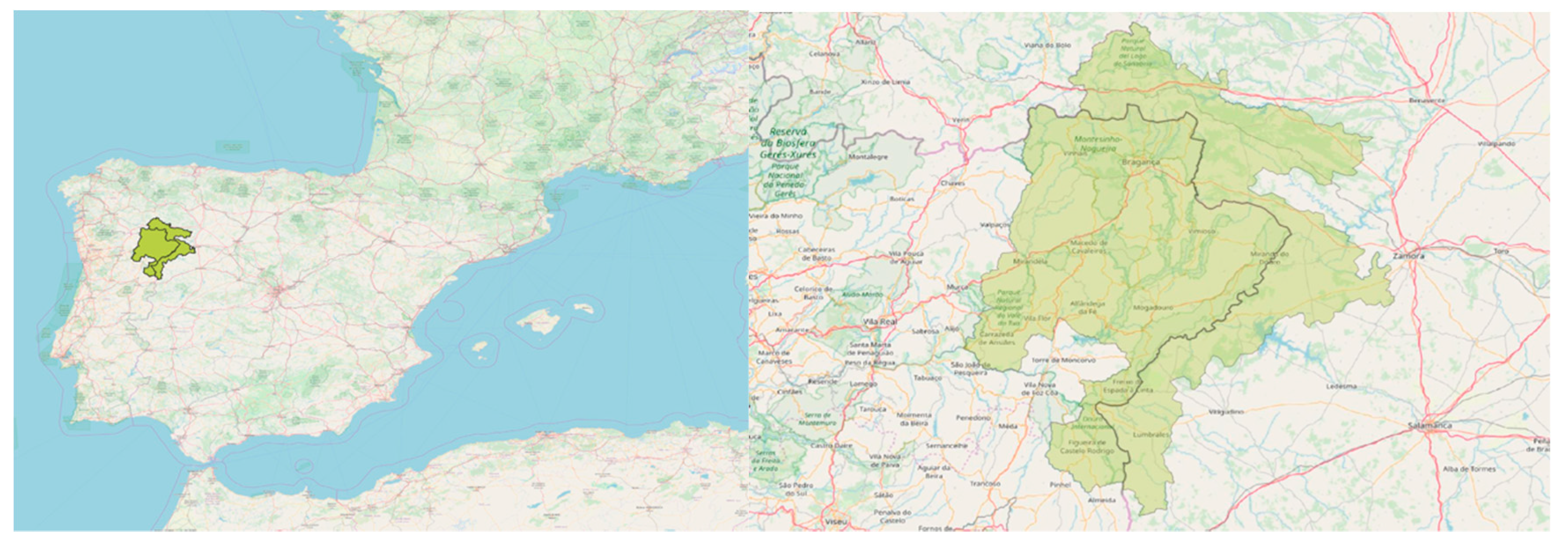
Iberian Plateau is a rural area declared as a Biosphere Reserve in 2015 that comprises of two protected areas of national interest and one of regional/local interest in Portugal: Parque Natural do Montesinho, Parque Natural do Douro International, and Paisagem Protegida da Albufeira do Azibo, respectively, and two protected areas in Spain: Parque Natural de Lago de Sanabria and surroundings and Parque Natural de Los Arribes del Duero. This area encompasses 12 Portuguese and 59 Spanish municipalities. Forty seven of the latter are located in Zamora and 12 in Salamanca. The total territory has an area of 1,132,607 hectares and a population density of 14 inhabitants per km
2. This territory is located between the Mediterranean and Eurosiberian biogeographical regions (
Figure 1) near the Atlantic coast and the climate is temperate sub-Mediterranean oceanic [
46].
The study area is representative of the mountainous landscape of the northwest of the Iberian Peninsula. Traditionally, the main economic activity has been linked to agriculture, although at the present time, a large part of the agricultural land has been abandoned and progressively covered by forest [
47]. The “border-effect” in cross-border territories involving Spain and Portugal, that is, the remote distance of these areas from economic and political centers of activity, results in an economic and social depression for these areas. This problem is aggravated by the abandonment of rural lands and the depopulation that it entails. This in turn results in the particular characteristics of these spaces: Aging population, weak economies of agglomeration, a rural development of polycentric settlement, and the progressive abandonment of traditional activities [
48].
The rural exodus of the last century, conflicts related to land management, firefighting, and the different political agendas and systems of land protection are characteristic of the study area and define its landscape. The progressive land abandonment and the high risk of fires require special attention in spatial planning in order to reduce the degree of conflict in land management [
49]. The local populations in the Iberian Plateau are mainly constituted by farmers, who generally keep stock, and are usually involved in forestry production. The industry related to “farming” has grown in recent years thanks to technological advances and innovations brought about by research centers and universities located in the area, both Portuguese and Spanish. Within the service industry, tourism has also had a very important growth in recent decades, gaining important weight in the economies of these municipalities. This includes hospitality, gastronomy, and other outdoors activities such as hiking, climbing, and other sports or leisure activities. Nature conservation has also attracted new inhabitants who are usually experts in biology, forestry, veterinary science, agriculture, environmental science or the arts, and who often work in local NGOs involved in the territory. In addition, Zamora and Bragança receive each year a large number of students and researchers with an interest in nature conservation. Lastly, employees of government institutions, whether at local, regional or national level, who are responsible for land management, also account for a significant proportion of the local population.
Since they became protected spaces in the 1970s, the rural areas that today are part of the Iberian Plateau Biosphere Reserve have been subject to conflicts related to land management between local stakeholders and the government. The feeling of belonging to a protected space is perceived by the local population as a source of restrictions on land use and loss of freedom. Moreover, the fact that local populations are not being included effectively in decision-making processes concerning land management is often a very important source of conflicts.
Spatial management is coordinated by regional governments and Spanish and Portuguese non-governmental organizations. Decision-making on the Iberian Plateau falls to ZASNET, a European Grouping of Territorial Cooperation (EGTCs) created in 2010 and coordinated in Bragança (Portugal). This institution includes, on the one hand, Zamora County Council, Salamanca County Council and Zamora City Council, in Spain, and on the other hand, the Associação de Municipios da Terra Fría do Nordeste Transmontano, Associação de Municipios da Terra Quente Transmontano, and Câmara Municipal de Bragança in Portugal. ZASNET presented its candidacy of Iberian Plateau for the MAB program and has been coordinating it since. As far as the reserve is concerned, these are the decision-makers of the Iberian Plateau.
3.2. Identification of Management Objectives and Stakeholders
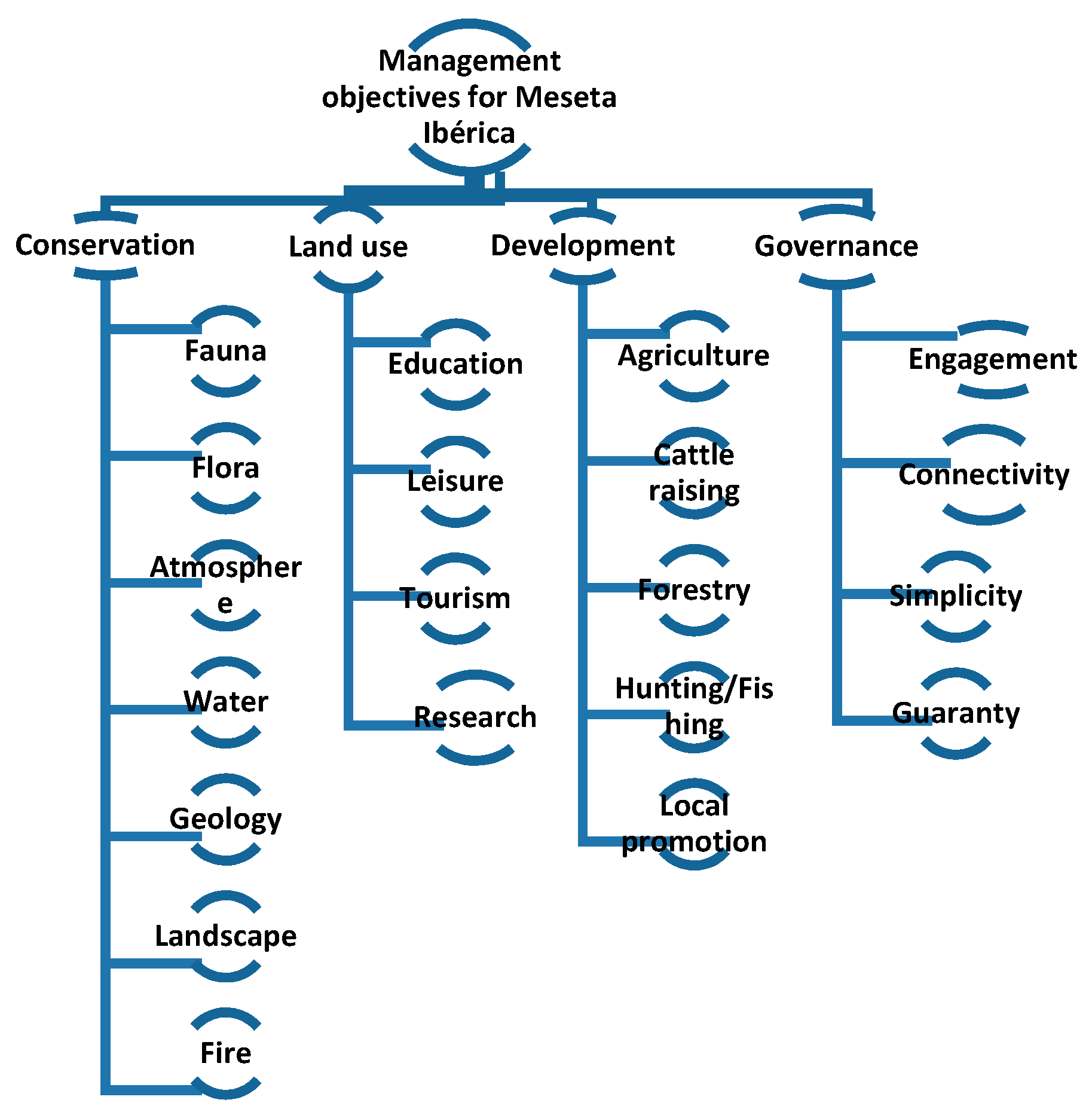
Management objectives were defined on the basis of a hierarchical structure, so that the main objectives were identified first and then the secondary objectives, which show a higher level of specificity. In order to identify the main objectives, this study took into account the three axes on which the categorization of biosphere reserves is based: Nature conservation, logistical support and development [
42], and the management objectives of the International Union for Conservation of Nature, namely, for the international category of Natural Park [
50]. In addition, a fourth objective associated with governance was considered due to the complexity of the governance structure of this rural area.
The secondary objectives were defined by considering the land plans of each of the four natural parks that make up the Iberian Plateau reserve as well as the strategic plan for the Iberian Plateau Biosphere Reserve: Plano de Ordenamento do Parque Natural do Montesinho, Plano de Ordenamento do Parque Natural do Douro Internacional, Plan de Ordenación de los Recursos Naturales del Parque Natural Arribes del Duero, and Plan de Ordenación de los Recursos Naturales del Lago de Sanabria and surroundings).
Stakeholders should be identified specifically for the area of study. For this purpose, personal interviews were conducted with representatives of local governments, technicians, and inhabitants of the region. To select the stakeholders, we used the snowball sampling technique until all the groups were well represented. This method is useful for obtaining representative samples when the total population is unknown [
51].
Once every stakeholder group was identified, a distinction was made between institutional agents with decision-making capacity and rural landowners who do not participate in spatial planning.
3.3. Collection and Aggregation of Individual Preferences Using a Voting Method
Using a voting method can be a good way of simplifying and making the process of collecting individual preferences more comprehensible. Voting methods have been the most widely used technique for adding individual preferences since the late 18th century. The Borda method was one of the first in incorporating these types of techniques and it is still today the bedrock of new methodologies [
52].
Voting methods have been widely used to solve decision-making problems in multidisciplinary contexts that involve multiple decision-makers. These methods are referred to as “soft systems” because they reflect the preferences of decision-makers in an orderly manner but not as rigid and structured as hard systems. Such methods are suitable for developing participatory processes as they are often simple to understand and apply. There are different types of voting methods, such as plural, multi-stage, or approval voting [
53]. The limitations associated with these methods lie in their manipulability or lack of rigor. This study uses a voting method based on the Borda count given that it is simple and difficult to manipulate, there are no Condorcet losers and verifies the conditions of consistency, monotonicity, and Paretian optimal [
54]. The aforementioned method takes into account the ranking of preferences of the voters over the candidates. When there are n candidates, each voter gives n votes to the preferred candidate, n-1 to the second candidate, and finally, a single vote to the least preferred candidate. The candidate with the most votes is the winner [
55]. In this study, the Borda method was used to elicit the participants’ preferences in a ranking that sorts the criteria by order of importance.
The stakeholders’ preferences are collected by means of a survey that makes it possible to establish a ranking of priorities on the management objectives identified as essential for adequate planning of the territory. Each participant gave n votes to their preferred objective, n-1 to the second preferred objective and finally 1 vote to the least desired objective. For example, to assess four management objectives, each participant assigned four points to their preferred objective, three points to the next most important objective, two points to the third most important objective, and one point to the objective they considered least important. The sum of the values assigned to each target provided a joint ranking for each group of objectives. Finally, all scores were normalized in order to obtain weights that represent the relative importance of each management objective.
Prior to the application of the method to the stakeholders of the Iberian Plateau reserve, a pilot study was carried out. In said study, by means of a face-to-face survey, 21 students and teachers of a degree in rural development and agronomy of the Instituto Politécnico in Bragança (Portugal) expressed their preferences on nine theoretical objectives relative to the management of one of the rural areas included in the Iberian Plateau. This study confirmed the usefulness of the voting method to include different participants in the prioritization of management objectives of the Montesinho Natural Park. The voting method proved to be a valid one for this purpose and yielded results similar to those obtained by applying an analysis of analytical hierarchies, a more rigorous method but also more complex and often difficult to understand. The results were presented at the III Ibero-American Congress of Entrepreneurship, Energy, Environment, and Technology [
56].
3.4. Comparative Analysis Between Decision-Makers and Rural Landowners
In order to ensure that institutional planning is in line with the preferences of rural landowners, the ranking of priorities on management objectives provided by institutional stakeholders was compared with the ranking of priorities on management objectives of all the stakeholders, including rural landowners.
3.5. Conflict Analysis
In this stage, we measured the conflict level of the objectives that exhibited discrepancies in the comparative analysis and identified the stakeholders among which there is a higher level of conflict. In doing so, we obtained enough information to improve communication and begin negotiations among the groups affected. In order to measure the level of conflict between the weights of every objective in each group, a Conflict Index was applied using Equation (1), which is based on Pang and Liang (2012) [
57]. This index makes it possible to measure the conflict generated between each individual assessment and the group assessment, but it also allows to identify the conflict generated between the assessments issued by different stakeholder groups.
where
represents the absolute difference between
and
, so
and
is the value assigned to each stakeholder’s or group of stakeholders’ a to each objective.
is the value of the collective preference for each management objective.
0. when N’s value is a = , then N = l, and N represents the greatest possible disagreement.
The value of the conflict index is always , when , the individual assessment will always match the collective assessment, that is, there will be maximum consensus, and when , the individual assessment will be the farthest away possible from the collective assessment, resulting in a maximum conflict.
5. Discussion
Conservation turned out to be the priority objective for all the stakeholders. These results fall in line with Sarkki, Heikkinen, Herva and Saarinen’s study [
58], showing the interest of the stakeholders closely linked to the land in preserving the natural resources. Nevertheless, whereas the ranking of the main objectives does not change when the preferences of the local community are incorporated, the same does not happen when the landowners’ preferences are incorporated into the analysis. This implies that local stakeholders have a different approach in comparison with institutional stakeholders when it comes to managing such objectives; and what is more, it also suggests that the concept of sustainable rural development may not be understood in the same way by all the stakeholders in the same space [
59].
These results validate the first two hypotheses put forward and show that incorporating the preferences of non-institutional stakeholders into spatial planning changes the priority management objectives; however, conservation objectives remain a priority in the protected rural area. It is important as well to pay attention to the differences in significance of the specific issues associated with each comprehensive management objective. This will make it possible to reach solutions that are as consensual as possible among all stakeholders.
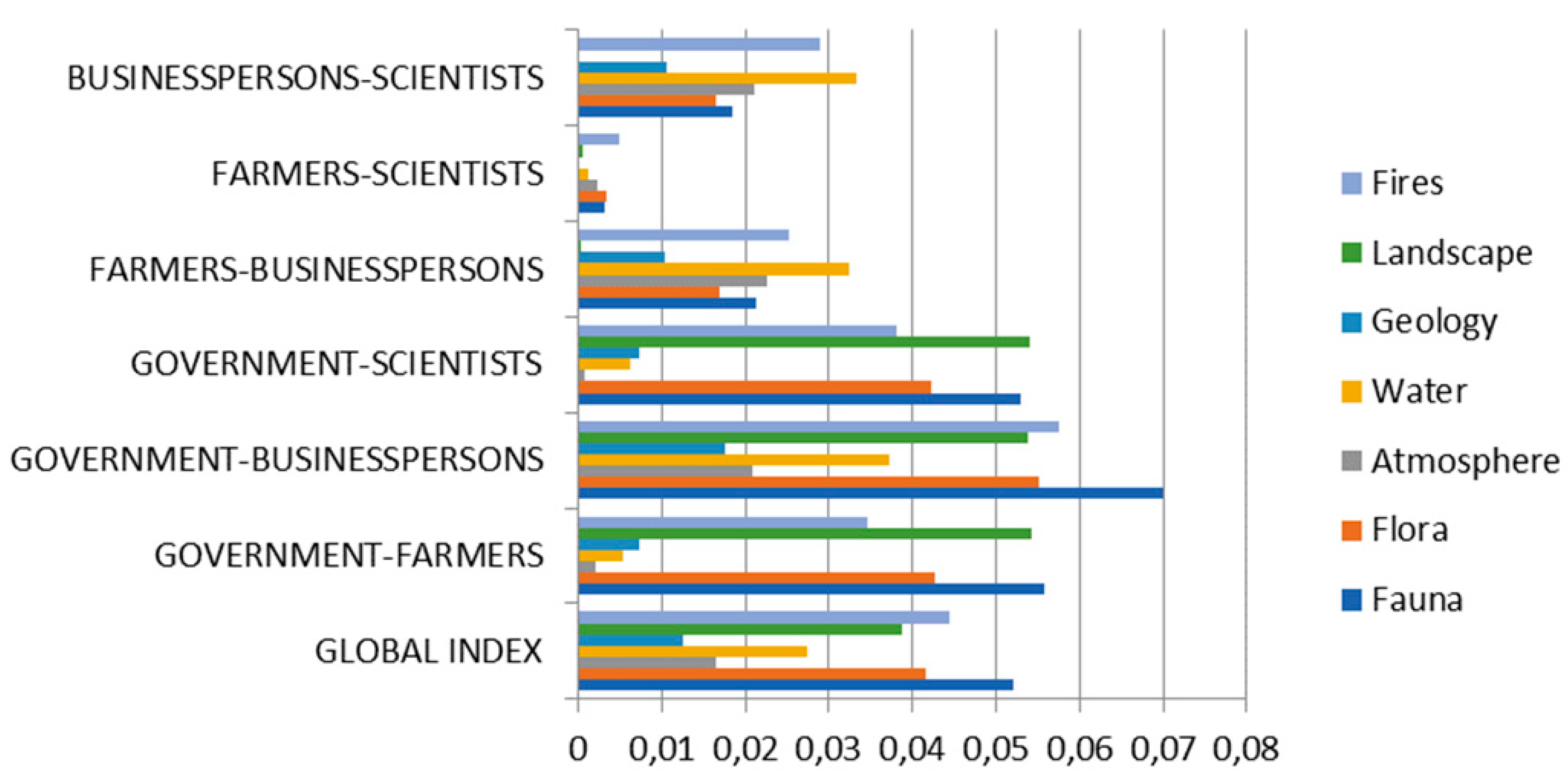
The priorities related to conservation objectives show that farmers and entrepreneurs consider it more important to deal with fires and water than with wildlife conservation. Thus, when the preferences of the local stakeholders are incorporated, water goes from the third to the first position, fauna conservation remains in second place, and fires scale one position (
Table 3). The highest conflicts were associated with wildlife conservation, fires, landscape conservation, and flora conservation, in this order of importance.
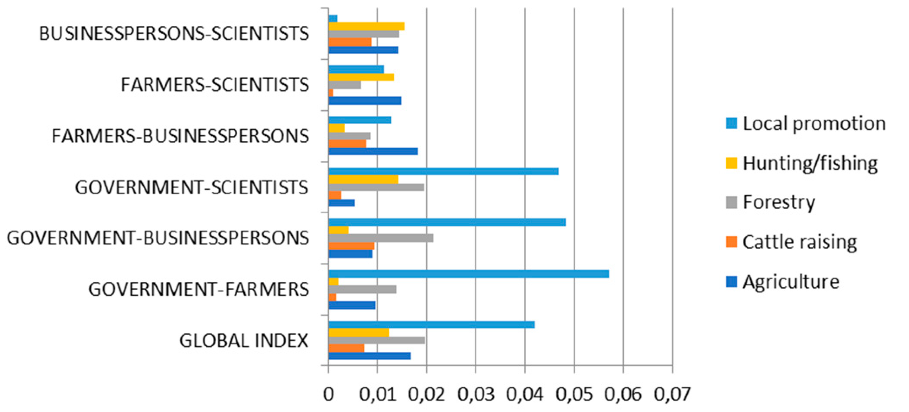
The ranking of development objectives also changed when the interests of landowners were considered. They prioritized forestry development, closely followed by the promotion of local products in second position and hunting and fishing in third position. However, the institutional ranking prioritized agriculture and cattle raising and left local promotion in the last position, which obtained the highest level of conflict. The joint ranking improved the position of local promotion from fifth to fourth place.
Rural land-use planning can be problematic if the interests of the local communities are not taken into account when managing such problems. However, in both cases, after incorporating the interests of landowners into the collective ranking, conservation and development objectives showed a similar assessment, which might help to reduce the level of conflict. On the other hand, the objectives relative to land use and governance showed similar priorities. It has been determined that the priority objective relative to land use was education, which obtained a similar ranking in every group. Governance objectives turned out to be the lowest priority; however, there is a high degree of consensus on prioritizing the participation of all the stakeholders in the area.
During the fieldwork phase, we were able to verify that the farmers and businesspersons were very interested in the conservation of natural resources, that is, the inhabitants of these regions who depend on the exploitation of natural resources. This may be due to the fact that if these resources were exhausted, their source of sustenance would, too, run out. On the other hand, the concept of “conservation” is seen by landowners as a source of restrictions upon the use of resources, but above all, as restrictions upon their ability to decide on land matters. The sophistication of the governance in protected spaces often hinders communication between institutional and local stakeholders, whose participation is confined to mere consulting processes without executive capacity, something that does not truly integrate their interests into spatial planning. In fact, 100% of the local stakeholders interviewed described themselves as “non-decision maker” in their own land. As Trillo-Santamaría and Paül [
60] emphasize, “the opinions, values, and feelings of the local population regarding a protected rural area must be a constant reason to take action”. It is possible that the failure to revitalize disadvantaged rural areas and to prevent the depopulation caused by certain conservation policies, proposed in good faith, may have its origin in the lack of effective and real integration of local communities in territorial planning. A first step towards the success of these integrative policies that seek to ensure the long-term coexistence of rural development and the conservation of the natural environment may lie in a strong commitment on the part of the authorities and institutions to involve the people who live in these areas in the planning of the territory.
In general, the greatest discrepancies were found between the government and the farmer group and between the government and the businesspersons group. This situation can derive in a series of conflicts that impede the good governance of this territory on the part of the local community and thus, hinder efficient sustainable management. Additionally, it would be advisable to establish channels that facilitate communication and, if necessary, initiate negotiation processes. At the same time, there are no discrepancies when it comes down to the preferences of local stakeholders, i.e., between entrepreneurs and farmers. Such robust agreement is critical in order to maintain the viability of rural populations, resulting in a strengthening of the local economy and the environment. McManus et al. [
61] observed that the quality of the local environment and the strong sense of belonging to the territory are fundamental factors in contributing to the cohesion of the local community and improving its resilience. In fact, several studies agree on the consolidation of the land in rural areas, through actual property rights and a sense of belonging, as the best tool for sustainability in European rural areas [
62].
The third hypothesis is thus discarded, since all the issues of the decision-making process did not arise a conflict after incorporating the interests of non-institutional stakeholders. Discrepancies have only been identified in the management objectives associated with use and development. It would be advisable to engage in negotiation processes with the groups of stakeholders that presented the highest levels of conflict in order to avoid an aggravation of the disagreements and a possible blockade in future decision-making processes.
Democracy is the only feasible form of government today. The challenge is to perfect it and restrict the democratic deficit [
63] by strengthening the relations between all individuals in a given space and ensuring their representation in decision-making processes. These ties can be strengthened by means of participatory processes that allow all the stakeholders to participate in the planning of rural protected areas, so as to generate structures of incentives versus structures of restrictions. Such structures of incentives would facilitate the coexistence of individuals, improve the structure of governance, and encourage the local inhabitants to take care of their land.
6. Conclusions
The method proposed in this paper has been useful to prioritize the management objectives of a protected rural area with a complex structure of governance and to incorporate in a simple way the preferences of the different stakeholders involved in said space. In the Iberian Plateau reserve, conservation and development objectives have proven to be the most important for all stakeholders.
The application of the method in a trans-boundary protected area has revealed important differences in the management when incorporating the priorities of the local stakeholders, such as landowners and local entrepreneurs, directly involved in the rural area. Particularly, the conservation of fauna and flora is considered a priority by decision-makers, whereas from the point of view of the local community, the priority is the conservation of water and fauna. The main conflicts are associated with issues related to the conservation of fauna and flora and the main discrepancies are those between the government and local entrepreneurs. The development objective that presented the greatest conflict between the government and the farmers was the promotion of local products. In addition, the study was able to observe the existence of strong associationism with no conflict between local groups, formed by farmers and businesspersons.
The proposed methodology could be of interest for application in other transboundary rural areas with the aim of simply integrating the interests of all the stakeholders involved in a protected rural location. On the other hand, the results presented in this study about the Iberian Plateau could be useful to the authorities and institutions that currently coordinate this area. First, to guide the planning process from the first stages. Second, to define channels of communication with the stakeholder groups that show the greatest level of conflict. Third, to open lines of negotiation aimed at reaching the maximum consensus on the priorities of the area’s management objectives and ensuring the sustainability of its planning.
The main limitations of this study were related with the lack of historic data about the application of participative multi-criteria methods in transboundary rural areas. It could be interesting to address new studies to the development of other easy-application participative methods, understandable for the local people that it allows the identification of consensual land management policies in protected rural spaces.


 ,
, 


