Article

Needs Assessment in Land Administration: The Potential of the Nominal Group Technique

1
Public Governance Institute, KU Leuven, Parkstraat 45 bus 3609, 3000 Leuven, Belgium
2
Faculty of Governance and Global Affairs, Leiden University, Wijnhaven Building, Turfmarkt 99, 2511 DP The Hague, The Netherlands
*
Author to whom correspondence should be addressed.
Submission received: 11 June 2018 / Revised: 5 July 2018 / Accepted: 17 July 2018 / Published: 20 July 2018

Abstract

:
This paper introduces the Nominal Group Technique (NGT) for conducting needs assessments in land administration projects. Understanding the local context of what citizens, communities and organisations need remains a complex challenge yet fundamental to the success of land administration projects. To date, key methods of understanding and identifying local needs have been qualitative in nature with various strengths and limitations. For land administration, it is also important for empirical methods to attend to power imbalances amongst participants that are a hallmark and driver of land tenure security. Although NGT has hardly been used in the domain of land administration, based on our experience of employing the method in a research project in East Africa, we argue that it presents a valuable addition to needs assessment strategies. We provide a broad outline of the method before providing a detailed description of how we employed the method. We discuss the opportunities and challenges that NGT offers, arguing that it is a time and resource efficient way of engaging communities in a participatory and equitable process which facilitates the co-production of valid and reliable knowledge on needs, and consensus on how these needs should be prioritised.

1. Introduction

The link between secure land rights, physical development, wealth creation and social justice is increasingly emphasised by global, regional and national agendas to the point that land administration systems (LAS) are now considered as critical public good infrastructures [1] and the focus of billions of dollars of foreign development aid [2]. However, this approach to funding has resulted in a tendency towards short-term approaches that favours the selection of technologies in response to project-based objectives over ensuring that users’ needs are appropriately evaluated and addressed [3,4]. Such projects have also been criticised for its lack of community engagement and needs assessment [5,6].
This is affirmed by academic literature on the challenges of recognising the characteristics of the political economy related to land tenure and land administration (such as colonial land redistribution practices, post-colonial land governance, neoliberal policies, subjugation of customary land tenure practices, gender, etc.) and accommodating these complexities within investigations [7,8,9,10,11,12]. This also bears out in a review of the World Bank’s land administration projects which found that “land issues are complex and the effectiveness of land reform interventions depends, in part, on their responsiveness to the specific local context” ([2], p.18).
In response, new approaches and frameworks have been developed—such as the Land Governance Assessment Framework (although this is not directly about needs assessment). These have tended to be applied at the national or sub-national level, a generalised approach where too often, local nuances that manifest as distinct land politics and land tenure arrangements become diminished [13]. More recent initiatives like the Social Tenure Domain Model (STDM) [14], the fit-for-purpose approach to building land administration systems [15], and the ideology of ‘responsible’ land administration [16] all seek to renew emphasis on a people- and communities-oriented approach to recording land tenure information. But how might this be achieved operationally by practitioners and researchers in the field? This question becomes more pertinent when we consider that in many countries around the world, a dearth of land professionals is leading to the growing use of para-professionals in the field.
The aim of this paper is to introduce the Nominal Group Technique (NGT) to researchers and practitioners in land administration. NGT was originally developed as tool for social psychological research and program planning in health [17]. It has since come to be considered as an effective and efficient group-based decision-making approach because it is easy to adopt, applicable to a variety of contexts, able to be incorporated within larger programs of work, delivers a high degree of participant satisfaction, and delivers robust outcomes which in turn appears to foster a stronger commitment by participants to act on the problem post-process [18,19,20,21]. Despite acknowledged benefits as an empirical participatory methodology, NGT has hardly been used in land administration research. Instead, understanding needs in land administration research has tended to use phenomena-based case studies [22] and other qualitative methods such as ethnographic research and action research (also known as action-oriented research) where interviews and focus group discussions dominate (e.g., see [23,24]) We acknowledge the potential of these techniques to yield similar outcomes in small group situations. However, such techniques often do not enable democratic prioritisation of ideas, which given the well-known issues of corruption in land that is borne out of elitism and patrimonialism (e.g., one of our case countries, Kenya, provides a solid example), this aspect seems particularly important to emphasise in data collection methods. In addition, the qualitative nature of data collected is sometimes difficult to present to decision makers in a way that is simple, comprehensible and representative. More generally, qualitative methods also tend to be time-consuming (e.g., in transcribing) and rely on specialised skillsets in interviewing, analysing, interpreting and validating the outcomes [25]. Alternatively, methods like multi-criteria decision analysis, often used in environmental research, can provide a more easily reportable dataset but these are often focused on evaluating different alternatives relevant to a specific goal [26]. This might not be suitable in more open-ended needs assessments especially if sets of alternatives are not readily apparent. There are also longstanding difficulties in collecting data in groups including distinguishing between the opinions of individuals’ versus the group, dependency on group dynamics, biased social judgements, measuring strength of consensus amongst participants, difficulty in interpreting the data, moderator or researcher bias and limitations in generalising [27,28,29]. Needs assessment methods must therefore be able to attend to such power imbalances that exist within a group data collection situation [30], but which also is a hallmark and inherent driver of land tenure security which can be translated into mapping and land administration interventions [31,32].
Answering these broad methodological questions and critiquing the benefits of qualitative versus quantitative methods lie outside the scope of this paper. This paper aims to describe our experiences using NGT in a land administration context and based on this, we argue that the method holds promise as a potential empirical method for land administration practitioners and researchers. We first broadly introduce NGT, providing an overview of the method, its protocol and its perceived advantages and disadvantages as a group-based data collection method. We will then present its application in the field, concluding with a discussion of the benefits and challenges in using the method in the domain of land administration.

2. The Nominal Group Technique (NGT)

Based on behavioural science principles, the Nominal Group Technique (NGT) is a highly structured process developed by Delbecq and Van de Ven [33] to facilitate both the elicitation of individual ideas pertaining to a problem as well as a group consensus. It also seeks to unravel the extent of the consensus within a group in a manner that aims to be comparably more equitable and time-efficient than other methods [34,35]. It is used to support the identification and prioritisation of problems and/or solutions amongst groups of stakeholders (also able to cater to different group sizes) by facilitating equal participation.
NGT has been used extensively in health, education and organisational research but applications in other fields have been becoming more common in recent years as the method becomes more well-known. These include fields such as environmental management (e.g., [36,37]), market research [20], information systems design and development [38]. Most applications of NGT have tended to focus on problem identification, solution development and establishment of priorities (in response to a topic) [39]. It is considered to be most useful when an identified problem requires a group’s ideas and evaluation [21]. As such, it has gained recognition as a method for stakeholder needs assessment [40,41].

2.1. NGT Process

Each NGT session comprises between five to nine participants with relatively homogenous characteristics (although larger groups have been used, e.g., in studies by Lloyd-Jones, Fowell and Bligh [42] and Twible [43]). Central to the data collection is the nominal question, which needs to be phrased simply, clearly and objectively such that minimal explanation of the question by the moderator and minimal interpretation of question by participants is required [44]. These can be:
  • Standalone questions, for example, “What measures should be taken to provide an anaesthetic service in areas which consistently fail to attract applicants for consultant posts?” ([44], p. 813).
  • Several simple questions, for example, “In what ways can the course be strengthened?” and “What are the strengths of the course?” ([45], p. 9).
  • A longer series of questions [35].
Typically, only one to two nominal questions are posed to the group per session as each question can take up to 2 h to complete. The general protocol for conducting an NGT session is described in detail in Table 1 and involves five main steps. This protocol is repeated for each question presented to the group. A moderator is present to lead the group through the process but should not interfere or influence the production of content.

2.2. Advantages and Disadvantages of NGT

For the researcher, NGT is considered to offer a number of advantages over other group decision-making processes. For example, quantitative approaches such as rank-based, satisfaction-based or choice-based analysis, while effective in eliciting preferences, often do not consider aspects like strength of preference or lend themselves to more sensitive analysis; qualitative methods such as focus groups and the Delphi method on the other hand can reveal rich data about choices and preferences but can be resource intensive and liable to embedding response bias if the moderator is not sufficiently skilled [49].
Comparably, NGT has proven to be resource efficient—with not much preparation required before hand and not requiring the researcher to be particularly skilled at moderating or interviewing. It is also time-efficient (requiring around two hours to complete the process for each nominal question posed if group size of five to nine participants are adhered to) given the high degree of task completion [39]. It specifically harnesses participants’ specific knowledge and experience to provide deep and meaningful results relative to the topic of interest [20] and does not require the researcher to be completely sensitive to the social and cultural contexts and perspectives of participants [50]. At the conclusion of the process for each nominal question, the researcher has effectively, an analysed outcome and processed set of data that does not require further interpretation. However, if further data analysis is required, this is generally considered to be fairly straightforward [50]. In addition, results have been shown to have strong reliability and validity compared to focus groups as a group-based data collection method [19,51]. For participants, NGT also offers a range of benefits. It provides a forum that facilitates their opinions and perspectives being voiced as well as an opportunity to honestly appraise a topic without repercussion through anonymous voting [46]. The iterative nature of eliciting input also overcomes problems of group dynamics in decision-making [34]. Studies have also shown that the process of decision-making and consensus development around priority setting leaves participants with a sense of accomplishment [52] and the coproduction of knowledge increases their ownership of the research [35].
Nonetheless, NGT has also drawn its share of criticisms. The highly structured process could come across as being too mechanical for participants, especially in less formal settings, resulting in difficulties in establishing a sense of cooperation and collaboration amongst participants [42]. Researchers who also conduct NGT sessions in larger groups may also find this more difficult to apply the approach effectively, impacting the time and resource efficiency of the method [42]. With multiple groups, data analysis can also become time-consuming [39]. Although there is considerable agreement across the literature on how to conduct an NGT session, a perceived disadvantage is also increasing modifications to the NGT protocol. Hugé & Mukherjee [36] noted that currently, there appeared to be increasing variation in how NGT is applied with no attempt to develop a typology of variants. Examples of modified NGT in the literature include modifications to the nature of participants (mixed instead of ensuring homogeneity), introducing other tools for rank ordering and to conduct multiple nominal groups in a study for comparing outcomes [48]. Other variations include conducting NGT verbally, using assistants when participants have low literacy [37], or enhancing the rank ordering process, for example, by using the analytic hierarchy process [53].
In this instance, the eventual selection of NGT as the main data collection strategy was motivated by several factors. First, the overall research project sought to deliver a generalised needs assessment predicated on multi-sectoral and multi-level data collection. Secondly, although the project had initially thought to apply methods like surveys and multi-criteria analysis, exploratory field visits soon revealed practical challenges that led to a revision of the research strategy to use qualitative strategies instead. These challenges included limited resources at local government levels, which meant that surveys were not entirely feasible. Methods also had to be relatively brief as local government offices were often understaffed and it was challenging gaining commitment to participate in the research. Thirdly, the initial visits also indicated that the project did not have sufficient insight into defining those options (either in terms of technologies or land information needs) required to perform a multi-criteria analysis. Fourthly, it became clear that in some of the target countries, there were levels of distrust between stakeholder segments and this issue had to be responded to sensitively. Fifth and finally, at least six different stakeholder classes were identified and conducting individual or even focus groups would require extensive data processing which would have been difficult to deliver considering the need to align with the project’s other technical work package development timelines.

3. NGT Application in Land Administration

3.1. The Decision-Making Context: Needs Assessment for Developing Alternative Land Tools

Responding to the global challenge of mapping millions of undocumented land rights to provide tenure security, the ‘its4land’ project aims to develop a suite of innovative geospatial tools to support land tenure recordation in East Africa, specifically in Ethiopia, Kenya and Rwanda. The first phase of the project focuses on contextualisation, that is, understanding and identifying the needs of stakeholders, that is, those information requirements and transaction processes necessary to support their individual or organisational aims with respect to security of tenure, aligning with broad concepts of needs assessments [40].
The objective of the needs assessment was to identify land tenure information needs in response to the challenge of sustainable urbanisation to understand how the four geospatial technologies that the research project was developing could meet these needs. All three case countries—Ethiopia, Kenya and Rwanda—were experiencing rapid urbanisation with effects being acutely felt by those communities in peri-urban areas, pastoral communities and those in secondary cities respectively. All three countries were at various levels of maturity in terms of their land administration system and quality of land tenure information:
  • Ethiopia: land tenure records have been produced incrementally through first and second level (which added a spatial component) certification programs funded by donors. This has targeted rural households but have also touched on urban areas and communal land. This has been a success story of affordable and rapid registration in a developing country context [54], yet there are still gaps in land tenure information and tenure security remains a significant challenge [55]. The nature of the Ethiopian federation, where progress in land administration is very much state-driven, means that there are varying levels of progress across the country.
  • Kenya: the 2010 Kenyan constitution guaranteed all Kenyans equal access to land and implementing this in land administration practices is now the responsibility of the 47 county governments. A particularly complex issue for Kenya is the registration of communal tenure, only recently acknowledged as a legal tenure type, estimated to account for two-thirds of land in Kenya (i.e., untitled) and supports about 10 million people and 70% of the livestock population [56]. Registration of communal land is a priority as it is often subject to urban sprawl and human-wildlife conflict. Kenya’s cadastral data suffers from significant issues including inaccurate boundary information, incomplete coverage and a high incidence of fraud.
  • Rwanda: major land reform in Rwanda was achieved through legal and policy reform and a large-scale, donor-funded Land Tenure Regularisation Program (LTRP) that removed customary forms of tenure and introduced individualised land rights. Using a systematic and participatory approach, the LTR demarcated and registered over 10 million parcels of land, providing the country with (almost) complete cadastral coverage. It also succeeded in vastly improving women’s rights to land [56] with more than 90% of land titles now including the name of a woman [57]. Nonetheless, the success of the program has raised new challenges as greater awareness of the value of land in land-scarce Rwanda has fuelled an increase in land disputes, especially within families and over parcels less than one hectare in size [58,59]. In addition, it remains uncertain to what extent the land administration system established by the LTRP is sustainable [59].

3.2. Data Collection

Ten workshops were held across the three countries with purposively sampled participants deemed to be experts in the topic. Validity in the NGT method is accounted for by recruiting participants who are considered able to provide expert opinions on the topic being investigated [60] and participants were nominated by the research project’s African partners. Groups ranged between five to nine people, which falls within NGT grouping recommendations as a small group consensus method. Workshops were conducted at local and national levels with between two to four questions were posed, depending on the length of the workshop (half days versus full days). At each workshop, one nominal question was posed: “In your experience, for (town/city/country name) to implement sustainable urbanisation policies, what land tenure and land-related information is still needed?”. The data presented in this paper relates to this question.
The nominal question was purposely left to be as broad as possible as the data serves as input into the development of four quite different technologies. In addition, land tenure security can be impacted by a range of land-related information and not just information regarding rights. In such data collection methods, it is inevitable that implicit bias is present and participants could subjectively interpret the question posed. In this instance, responding to recognition that being responsive to local context is paramount in successful land administration interventions, subjective understanding and interpretation was actually deemed to be desirable. However, participants were given parameters to enable consistency in structuring responses (such as being specific when raising aspects of data quality and accuracy) and group discussions provided opportunities for moderators to question and provoke reflection around perceived implicit biases.
In the first workshop, data was collected using post-it notes placed on the wall. This had practical challenges (e.g., coming off the wall, having to re-cord the data, etc.); therefore in subsequent workshops, participants recorded their thoughts privately on provided pen and paper and as input was voiced aloud, this was noted and numbered on an excel spreadsheet projected on the wall or a large screen (where available). The use of a spreadsheet was not only more efficient, it was a more effective format for facilitating participation as participants found it difficult to see the post-it notes, as well as handle them manually for grouping. We also worked from the premise that all ideas started off with an equal weight. Hard copy voting sheets were provided to participants, who voted individually (and anonymously) and provided this to the moderator to tally. The process of tallying the scores was not conducted publicly but the distribution of scores and the voting outcomes were projected onscreen for participants to view. The voting sheets were retained as research data.

3.3. Data Analysis

3.3.1. Individual Workshop Datasets

The workshops yielded rich qualitative data. For example, the number of needs raised in response to the nominal question ranged from 14 to 45. Each workshop’s outcomes were finalised at its conclusion, yielding a table of land information needs responding to the nominal question and priorities as determined by the voting process. This was presented to stakeholders. For the purposes of expediency, participants were only shown the final tally and not the distribution of votes across participants (even though this is not identifiable). This produced the initial qualitative and quantitative outcomes of the workshops. An example is shown in Table 2 (round 1) and Table 3 (round 2). From the final voting outcome in Table 3, it is evident that there are some clear priorities in terms of land tenure and/or land information needs amongst the group, followed mainly by items tied in terms of voting score tally.
The data derived from the workshops can, in effect, stand on their own. They provide not only an indication of the extent of group consensus on the final prioritised needs but there is a record of individual perspectives and priorities as well. To further analyse the data, in post-workshop analysis, we followed McMillan et al.’s [48] approach to improve the quantitative analysis of the data, calculating:
  • strength of consensus of the group pertaining to the importance of each item (i.e., sum of all votes per item, otherwise shown as ‘tally’ in Table 2 and Table 3).
  • popularity of the idea (i.e., voting frequency for each item) amongst participants.
  • relative importance of each item within that dataset, where relative importance is calculated by the equation:
    ( score   achieved   for   item   ÷   maximum   points   for   the   group   ( i . e . , participant   number   ×   15   points )   ×   100 % )
    (which simply reflects how much weight (total votes gained) a particular land information need carried as a percentage of the total possible votes given the number of participants in that group).
  • rank ordering of priority of the items; if there is a draw, the higher rank is accorded to the item with a higher voting frequency.
Using this method, the processed outcome of the data in Table 3 is presented in Table 4 with new rank ordering of priority shown in bold (after taking frequency of vote into consideration). This provided a quantitative approach to delineating those land information needs considered to be the most important (i.e., enabling identification of top five ranked items).

3.3.2. Synthesising Multiple Individual Datasets

Up to this point, analysis of the NGT data pertaining to individual workshops is relatively straightforward. However, if the researcher intends to synthesise the outcomes to report on outcomes at a higher level (as it was in our case aggregating outcomes at the country level and comparing outcomes between countries and across stakeholder groups), it becomes necessary to use the qualitative data as the basis for analysis.
The qualitative data was content analysed by the research team to identify commonalities and differences of land information needs as a way to understand the overarching aim of the research project as to how the various technologies being developed might help address these needs. To do so, a three-level coding framework was developed by the research team to ensure consistency of the coding across the multiple datasets. It mainly employed first and second cycle coding strategies as outlined by Saldaña [61]. An initial inductive coding of the data using a structural coding approach organised the data into land information needs that corresponded to the functionalities of the proposed tools, that is, a first level classification of the data into the categories of data inputs and data use and management.
Following this, a second cycle of coding applying a focused coding approach further classified the data based on conceptual similarities in land information needs. This produced greater definition of six themes of land information needs as shown in Figure 1. Thereafter, axial coding was used as a supplementary method to define the categories under each them and explore how these might relate to each other. Of interest here was how common a theme was, that is, how often a relevant code under a theme occurred in the data [62] and the metric used to quantify this for comparative purposes was frequency of code occurrences—an adaptation of a large sample analytical method for NGT-based studies [63].
  • All raw textual data was subsequently re-coded in the RQDA software environment using the coding framework (RQDA is an open source R package for qualitative data analysis—see http://rqda.r-forge.r-project.org/). Refinements were made to codes along the way to support abstraction, comparison, dimensionalisation, refutation and integration [64]. While data gathered through the workshops aimed to be as unambiguous as possible, this was not always the case and sometimes had to be further disambiguated during the coding process. For this reason as well, incorporating the number of votes in the analysis would have been problematic. For example, as shown in Figure 2, the phrase, “Subject information (e.g., name, gender, address of owner if not the subject, etc.” was separated into two codes that reflect different types of information: ‘socio-economic attribute’ to capture data like name, gender and other owner and ‘other ownership evidence’ reflects other types of data to support clarity of ownership, in this instance the address of the owner if he/she does not live at the property.
  • Analysis of the frequency of the codes was performed within RQDA. This sought to understand how often these needs were mentioned across the different stakeholder segments. To represent this, the number of occurrences of a code was used as an indicative metric for relative importance of that need. Therefore, the relative importance of the need or theme of land information need across the entire cohort of stakeholders (i.e., how often this code occurred across the corpus of data) was calculated as:
    ( Total   no .   of   code   occurrences   for   a   specific   dimension Total   no .   of   code   occurrences   recorded   for   the   whole   theme )   × 100 %
Cross-country analysis of the codes was undertaken by processing the outcomes from RQDA in Microsoft Excel.
To contextualise the analytical steps described above, the processed data from NGT workshops conducted in Rwanda is shown in Table 5 below. The column on the left describes the major themes and their subcategories; the numbers indicate the frequency which the code occurred in the dataset for each thematic category per stakeholder group.
Table 5 indicates that the needs identified by Rwandan stakeholders were fairly consistently experienced or recognised across stakeholder groups. Importantly, this consistency suggests that the data collected through the NGT method is reliable [60]. A clear majority of the codes were related to the need for non-cadastral data, followed by needs in cadastral data and data management. Minor needs were coded to be related to stakeholder engagement processes and data analysis functions.

4. Discussion

In response to the growing recognition that effective land administration projects must be attentive to localised needs and that the nature of land-related decision making is inherently fraught, this paper aimed to introduce the Nominal Group Technique (NGT) as a potential addition to the methodological toolkit for land administration researchers and practitioners. Our experience of using NGT in a research project based in East Africa to collect land information needs of stakeholders at multiple levels provided the basis for discussing the applicability of the method, its opportunities and challenges.

4.1. Data Collection and Participation

We found that the iterative nature of the process worked well to provide all participants with, at least, an opportunity to voice their opinions. In some groups, dominant participants tended to want to speak all the time, or convince others to agree with what they were saying—at which point we as moderators intervened. In larger groups, we found that the time it took to input and tally the votes often took slightly longer than the time participants needed to ponder and record their priorities. This contributed to a loss in momentum in conducting the workshop; nonetheless, most discussions were spirited and being able to quantify opinions in terms of numbers provided an advantageous focal point in terms of understanding degree of agreement or divergence over the prioritisation of land information needs. This also facilitated the groups’ ability in reaching consensus. Consensus is important here for democratic prioritisation of land information needs as a homogenous group but the differences in opinions relative to priorities is equally captured, which enables further research to be undertaken if needed into underlying drivers and motivations.
Our experience reinforces the literature which finds that smaller groups are more effective in terms of participation and maintaining a good momentum in the group, especially in the round-robin aspect of soliciting input. In our experience, it was also more likely in the larger groups for participants to say that their ideas had been covered by the group, reducing their participation. We also attempted to pose more than one nominal question in the earlier workshops but found that participants were fatigued after the first question, demonstrated by the slower pace and increased prompting by us as moderators.

4.2. Data Analysis and Outcomes

The data produced from the workshops was rich. It not only revealed differences between stakeholders at different levels but also between countries. Admittedly, the analysis of these similarities and differences can be alluded to by the quantitative aspects of the NGT outcomes but an interpretive analysis is likely to be more conducive to generating insights. Most participants were gratified at being able to see the opinions of their group as a collective and were satisfied at being able to see their effort consolidate into a reportable outcome; most took photographs of the final slides as a record of their work to report back to their organisations. Validity was accounted for through the use of experts as recommended and the high degree of consistency in outcomes across datasets indicate the data was reliable. Initially however, we had overlooked the distribution of scores across needs per participant and had to re-do the analysis. In this research, a definite advantage of using the NGT was the minimal interpretation required of participants’ qualitative data pertaining to individual workshops (especially when we sought to emphasise the need to provide specific needs) and the fact that we had a final dataset for that group at the conclusion of the workshop which did not need further processing. This advantage should not be underestimated if data collection is conducted on a larger scale. As researchers who travelled constantly during fieldwork, the portability of the research data and the fact that the datasets were easily, safely and securely archived was also beneficial.
We found that the data analysis requires more time, effort and skill than indicated in the literature on NGT particularly as we sought to synthesise and compare findings from multiple groups and across countries. The quantitative analysis was relatively simple as we could only do this for individual workshop outcomes; however, analysis of the qualitative data required experience with content analysis and in this case, coding and interpretation, as well as introducing the potential for researcher bias. To note, these are not necessarily skills taught in land administration programs, which tend to be based in science or engineering schools. We also found that as the data became synthesised for higher-level analysis, it loses the absolute impact that the quantitative data provides the research outcomes for individual group datasets. In our case, the use of the frequency of code occurrences as a proxy for indicating relative importance of land information needs was also, admittedly, a blunt instrument.

4.3. Ease of Execution

For the most part, our use of NGT adhered with the prescribed approach and followed the main steps to generate small group consensus on land information needs and priorities. We kept our groups consistent with the recommended size (between five to nine participants) and maintained homogenous groups (recruiting participants according to their sectors, that is, government, non-government, industry, etc.) for each workshop except for one workshop in Rwanda, where poor response rates forced us to combine a workshop with participants from the private sector and academia. Although we used a projected spreadsheet as the means of displaying data, we believe this still aligned with the principles of the NGT protocol. Our obvious point of difference was in conducting multiple NGT groups which aimed to construct a local-to-national comparison, a national perspective and consequently, a regional perspective and comparison. We also acknowledge that our experience was not tested in difficult field conditions and we did not use this method with community groups nor in situations where literacy might be an issue.
Nonetheless, our experience reinforces the major benefits of NGT as an empirical instrument. We found it to be highly efficient in terms of time, costs and preparations, with most responses to the nominal question being received, prioritised and agreed upon within the timeframe of 1.5 to 2 h. We found the initial use of post-it notes cumbersome and it was also more difficult to keep an accurate record of the ideas generated, leading to the switch to a spreadsheet. The structure of the workshop also appeared to be easy to understand although at some of the more local levels, we received feedback from participants that this was the first time they had been involved in a workshop where they had to provide input. Any questions participants had on the procedure were easily clarified once the process commenced. After the first workshop, it became evident that the nominal question needed to be clearer, for example, there was a tendency to conflate needs with challenges. To overcome this, subsequent workshops encouraged participants to provide very specific needs and provided examples.

4.4. Overall Recommendations

Our experience of using NGT for needs assessment and our recommended solutions, is summarised in Table 6.
On balance, we argue that NGT is a beneficial and productive addition to the land administration methodological toolkit, especially to support local needs assessment. In comparison with other group interviews that the authors have conducted in land administration research, the structure of the NGT does indeed offer an effective method in terms of enabling participation, knowledge production and knowledge ownership and limiting researcher bias–all of which could be perceived to align with the ideals of fit-for-purpose land administration and responsible land administration. NGT is also simple to conduct and cheap; however, in more rural areas, it might be more difficult to get communities to commit to a sufficient length of time. For example, local government stakeholders in Kenya could not afford to spend more than half a day out of the office, which restricted the group to only one nominal question. The simplicity of the method and our experience of using a spreadsheet, also suggests that the method is easily scalable and could be adopted and used widely by a range of stakeholders with minimal training.
The challenge in using the method is in the analysis and in attempting to construct a larger dataset made of datasets from multiple NGT groups. The quantitative analysis is relatively simple and could be set up as a template in a spreadsheet; analysis of the qualitative data however, will require someone with greater skill and experience in appropriate methods. The fact that there still remains no standard method to synthesising multiple NGT datasets could also be a hurdle to scaling the method for broader implementation. Future research could consider how the quantitative aspects of the individual groups could be aggregated or accommodated at a meta-level analysis. The overall advantages and disadvantages of NGT as a method are outlined in Table 7.

5. Conclusions

Understanding the local context of what citizens, communities and organisations need from land administration systems remains a complex challenge, yet fundamental to the success of land administration projects. To date, key methods of understanding and identifying local needs have been interviews, focus groups and action research. Based on our experience of employing the Nominal Group Technique (NGT) in a research project in East Africa, we argue that NGT, as a small group consensus method, presents a valuable contribution to the land administration methodological toolkit, especially if used in combination with other methods, for identifying and prioritising local needs. NGT is a participatory way of enabling a group to co-produce knowledge on their needs and how these should be prioritised. Its highly structured approach offers a mitigating strategy to seeking input on land-related issues in a group setting, where inherent land-related politics and power imbalances can become further exacerbated by group dynamic issues. However, we acknowledge that our argument is limited by the low application rate of NGT in land administration and our findings would benefit from further instances of use. Conversely, this low incidence of use also signifies the potential for NGT to be used more widely in land administration to enable the collection and construction of stakeholders’ needs and priorities in a way that preserves the integrity and diversity of their local contexts.

Author Contributions

Conceptualisation, S.H.; V.P.; B.B. and J.C.; Methodology, S.H.; V.P.; B.B.; Formal Analysis, S.H.; V.P.; B.B. and J.C.; Investigation, S.H.; Writing—Original Draft Preparation, S.H.; V.P.; B.B.; Writing—Review & Editing, S.H.; V.P.; B.B. and J.C.; Project Administration, S.H.; Funding Acquisition, J.C.

Funding

This research was funded by the European Commission Horizon 2020 Framework Program grant number 687828.

Conflicts of Interest

The authors declare no conflict of interest.

References

  1. Bennett, R.; Tambuwala, N.; Rajabifard, A.; Wallace, J.; Williamson, I. On Recognizing Land Administration as Critical, Public Good Infrastructure. Land Use Policy 2013, 30, 84–93. [Google Scholar] [CrossRef]
  2. Independent Evaluation Group. Lessons from Land Administration Projects: A Review of Project Performance Assessments; Working Paper; Independent Evaluation Group: Washington, DC, USA, 2016. [Google Scholar]
  3. Magis, M.; Zevenbergen, J. Towards Sustainable Land Administration Systems: Designing for Long-Term Value Creation. In FIG Congress 2014, 16–21 June 2014; International Federation of Surveyors: Kuala Lumpur, Malaysia, 2014. [Google Scholar]
  4. Bennett, R.M.; Alemie, B.K. Fit-for-Purpose Land Administration: Lessons from Urban and Rural Ethiopia. Surv. Rev. 2016, 48, 11–20. [Google Scholar] [CrossRef]
  5. Bruce, J. Simple Solutions to Complex Problems: Land Formalisation as a “Silver Bullet”. In Fair Land Governance: How to Legalise Land Rights in Rural Development; Otto, J.M., Hoekema, A.J., Eds.; Leiden University Press: Leiden, The Netherlands, 2012; pp. 31–56. [Google Scholar]
  6. Fernandes, E.; Smolka, M.O. Land Regularization and Upgrading Programs Revisited. Land Lines 2004, 16, 12–16. [Google Scholar]
  7. Boone, C. Land Tenure Regimes and State Structure in Rural Africa: Implications for Forms of Resistance to Large-Scale Land Acquisitions by Outsiders. J. Contemp. Afr. Stud. 2015, 33, 171–190. [Google Scholar] [CrossRef] [Green Version]
  8. Davies, S. The Political Economy of Land Tenure in Ethiopia; University of St Andrews: St Andrews, Scotland, 2008. [Google Scholar]
  9. Fay, D. Land Tenure, Land Use, and Land Reform at Dwesa–Cwebe, South Africa: Local Transformations and the Limits of the State. World Dev. 2009, 37, 1424–1433. [Google Scholar] [CrossRef]
  10. Lund, C. Legitimacy, Land & Democracy in Niger. Rev. Afr. Polit. Econ. 1997, 24, 99–112. [Google Scholar]
  11. Lund, C.; Boone, C. Introduction: Land Politics in Africa—Constituting Authority over Territory, Property and Persons. Africa 2013, 83, 1–13. [Google Scholar] [CrossRef]
  12. Ossome, L. Can the Law Secure Women’s Rights to Land in Africa? Revisiting Tensions between Culture and Land Commercialization. Fem. Econ. 2014, 20, 155–177. [Google Scholar] [CrossRef]
  13. Alemie, B.K.; Bennett, R.M.; Zevenbergen, J. A Socio-Spatial Methodology for Evaluating Urban Land Governance: The Case of Informal Settlements. J. Spat. Sci. 2015, 60, 289–309. [Google Scholar] [CrossRef]
  14. Augustinus, C. Social Tenure Domain Model: What It Can Mean for the Land Industry and for the Poor. In Proceedings of the FIG Congress, Sydney, Australia, 11–16 April 2010. [Google Scholar]
  15. Enemark, S.; Bell, K.C.; Lemmen, C.; McLaren, R. Fit-For-Purpose Land Administration; FIG/World Bank Publication: Copenhagen, Denmark, 2014. [Google Scholar]
  16. De Vries, W.T.; Bennett, R.M.; Zevenbergen, J. Toward Responsible Land Administration. In Advances in Responsible Land Administration; CRC Press: Boca Raton, FL, USA, 2015; pp. 3–14. [Google Scholar]
  17. Delbecq, A.L.; Van de Ven, A.H.; Gustafson, D.H. Group Techniques for Program Planning: A Guide to Nominal Group and Delphi Processes; Scott, Foresman: Glenview, IL, USA, 1975. [Google Scholar]
  18. Bartunek, J.M.; Murninghan, J.K. The Nominal Group Technique: Expanding the Basic Procedure and Underlying Assumptions. Group Organ. Stud. 1984, 9, 417–432. [Google Scholar] [CrossRef]
  19. Langford, B.E.; Schoenfeld, G.; Izzo, G. Nominal Grouping Sessions vs. Focus Groups. Qual. Mark. Res. Int. J. 2002, 5, 58–70. [Google Scholar] [CrossRef]
  20. Lloyd, S. Applying the Nominal Group Technique to Specify the Domain of a Construct. Qual. Mark. Res. Int. J. 2011, 14, 105–121. [Google Scholar] [CrossRef]
  21. Sink, D.S. Using the Nominal Group Technique Effectively. Natl. Prod. Rev. 1983, 2, 173–184. [Google Scholar] [CrossRef]
  22. Çağdaş, V.; Stubkjær, E. Doctoral Research on Cadastral Development. Land Use Policy 2009, 26, 869–889. [Google Scholar] [CrossRef] [Green Version]
  23. Daley, E.; Lanz, K.; Grabham, N.; Munkhtuvshin, B.; Narangerel, Y.; Driscoll, Z.; Lkhamdulam, N.; Grabham, J.; Suvd, B. Gender, Land and Mining in Mongolia; Mokoro Ltd.: Oxford, UK, 2018. [Google Scholar]
  24. Duban, E. Tajikistan: Country Gender Assessment; Asian Development Bank: Manila, Philippines, 2016. [Google Scholar]
  25. Creswell, J.W. 30 Essential Skills for the Qualitative Researcher; SAGE Publications, Inc.: Thousand Oaks, CA, USA, 2016. [Google Scholar]
  26. Esmail, B.A.; Geneletti, D. Multi-Criteria Decision Analysis for Nature Conservation: A Review of 20 Years of Applications. Methods Ecol. Evol. 2018, 9, 42–53. [Google Scholar] [CrossRef]
  27. Sim, J. Collecting and Analysing Qualitative Data: Issues Raised by the Focus Group. J. Adv. Nurs. 1998, 28, 345–352. [Google Scholar] [CrossRef] [PubMed]
  28. Stewart, D.W.; Shamdasani, P.N. Focus Groups: Theory and Practice, 3rd ed.; SAGE Publications Inc.: Thousand Oaks, CA, USA, 2015. [Google Scholar]
  29. Toner, J. Small Is Not Too Small: Reflections Concerning the Validity of Very Small Focus Groups (VSFGs). Qual. Soc. Work 2009, 8, 179–192. [Google Scholar] [CrossRef]
  30. Stewart, D.; Shamdasani, P.; Rook, D. Group Dynamics and Focus Group Research. In Applied Social Research Methods: Focus Groups; Stewart, D.W., Shamdasani, P.N., Rook, D.W., Eds.; SAGE Publications, Ltd.: Thousand Oaks, CA, USA, 2007; pp. 19–36. [Google Scholar]
  31. Moody, R. Mapping Power: Geographical Information Systems, Agenda-Setting and Policy Design; Erasmus University: Rotterdam, The Netherlands, 2010. [Google Scholar]
  32. De Vries, W.T. A Review of the Political Nature of ICT in G2G Integration: Based on 3 Cases from the GeoICT Domain. In dg.o’08: Proceedings of the 2008 International Conference on Digital Government Research; Digital Government Society of North America: Los Angeles, CA, USA, 2008; pp. 124–131. [Google Scholar]
  33. Delbecq, A.L.; Van de Ven, A.H. A Group Process Model for Problem Identification and Program Planning. J. Appl. Behav. Sci. 1971, 7, 466–492. [Google Scholar] [CrossRef]
  34. Hutchings, H.A.; Rapport, F.L.; Wright, S.; Doel, M.A. Obtaining Consensus from Mixed Groups: An Adapted Nominal Group Technique. Br. J. Med. Med. Res. 2013, 3, 491–502. [Google Scholar] [CrossRef]
  35. Harvey, N.; Holmes, C.A. Nominal Group Technique: An Effective Method for Obtaining Group Consensus. Int. J. Nurs. Pract. 2012, 18, 188–194. [Google Scholar] [CrossRef] [PubMed]
  36. Hugé, J.; Mukherjee, N. The Nominal Group Technique in Ecology and Conservation: Application and Challenges. Methods Ecol. Evol. 2018, 9, 33–41. [Google Scholar] [CrossRef]
  37. Maynard, L.; Jacobson, S.K. Stakeholder Participation in Wildlife Management: Adapting the Nominal Group Technique in Developing Countries for Participants with Low Literacy. Hum. Dimens. Wildl. 2017, 22, 71–82. [Google Scholar] [CrossRef]
  38. Spencer, D.M. Facilitating Public Participation in Tourism Planning on American Indian Reservations: A Case Study Involving the Nominal Group Technique. Tour. Manag. 2010, 31, 684–690. [Google Scholar] [CrossRef]
  39. Potter, M.; Gordon, S.; Hamer, P. The Nominal Group Technique: A Useful Consensus Methodology in Physiotherapy Research. N. Z. J. Physiother. 2004, 32, 126–130. [Google Scholar]
  40. Witkin, B.R.; Altschuld, J.W. Planning and Conducting Needs Assessments: A Practical Guide; SAGE Publications Inc.: Thousand Oaks, CA, USA, 1995. [Google Scholar]
  41. WBI Evaluation Group. Nominal Group Technique. World Bank Needs Assessment Knowledge Base; The World Bank: Washington, DC, USA, 2007. [Google Scholar]
  42. Lloyd-Jones, G.; Fowell, S.; Bligh, J.G. The Use of the Nominal Group Technique as an Evaluative Tool in Medical Undergraduate Education. Med. Educ. 1999, 33, 8–13. [Google Scholar] [CrossRef] [PubMed]
  43. Twible, R.L. Consumer Participation in Planning Health Promotion Programmes: A Case Study Using the Nominal Group Technique. Aust. Occup. Ther. J. 1992, 39, 13–18. [Google Scholar] [CrossRef]
  44. Horton, J.N. Nominal Group Technique. Anaesthesia 1980, 35, 811–814. [Google Scholar] [CrossRef] [PubMed]
  45. Gallagher, M.; Hares, T.; Spencer, J.; Bradshaw, C.; Webb, I. The Nominal Group Technique: A Research Tool for General Practice? Fam. Pract. 1993, 10, 76–81. [Google Scholar] [CrossRef] [PubMed]
  46. Boddy, C. The Nominal Group Technique: An Aid to Brainstorming Ideas in Research. Qual. Mark. Res. Int. J. 2012, 15, 6–18. [Google Scholar] [CrossRef]
  47. Delp, P.; Thesen, A.; Motiwalla, J.; Seshardi, N. Nominal Group Technique. In Systems Tools for Project Planning; International Development Institute: Bloomington, IN, USA, 1977; pp. 14–17. [Google Scholar]
  48. McMillan, S.S.; Kelly, F.; Sav, A.; Kendall, E.; King, M.A.; Whitty, J.A.; Wheeler, A.J. Using the Nominal Group Technique: How to Analyse across Multiple Groups. Heal. Serv. Outcomes Res. Methodol. 2014, 14, 92–108. [Google Scholar] [CrossRef]
  49. Ryan, M.; Scott, D.A.; Reeves, C.; Bate, A.; van Teijlingen, E.R.; Russell, E.M.; Napper, M.; Robb, C.M. Eliciting Public Preferences for Healthcare: A Systematic Review of Techniques. Health Technol. Assess. 2001, 5, 1–186. [Google Scholar] [CrossRef] [PubMed]
  50. Van der Laenen, F. Not Just Another Focus Group: Making the Case for the Nominal Group Technique in Criminology. Crime Sci. 2015, 4, 5. [Google Scholar] [CrossRef] [Green Version]
  51. Langford, B. Nominal Grouping Sessions. Mark. Res. 1994, 6, 16–21. [Google Scholar]
  52. Gresham, J.N. Expressed Satisfaction with the Nominal Group Technique among Change Agents; A Summary Report of Research; Departmental Information Bulletin 86-1 [Microform] Jon N. Gresham; Distributed by ERIC Clearinghouse: Washington, DC, USA, 1986. [Google Scholar]
  53. Parthasarathy, S.; Sharma, S. Determining ERP Customization Choices Using Nominal Group Technique and Analytical Hierarchy Process. Comput. Ind. 2014, 65, 1009–1017. [Google Scholar] [CrossRef]
  54. Deininger, K.; Ali, D.A.; Holden, S.; Zevenbergen, J. Rural Land Certification in Ethiopia: Process, Initial Impact, and Implications for Other African Countries. World Dev. 2008, 36, 1786–1812. [Google Scholar] [CrossRef]
  55. Daley, E.; Dore-Weeks, R.; Umuhoza, C. Ahead of the Game: Land Tenure Reform in Rwanda and the Process of Securing Women’s Land Rights. J. East. Afr. Stud. 2010, 4, 131–152. [Google Scholar] [CrossRef]
  56. Njagi, T. Communal Land Good for Pastoralists in Kenya. The Standa, 25 May 2016. [Google Scholar]
  57. DAI. Rwanda—Support for Land Tenure Regularisation. Available online: https://www.dai.com/our-work/projects/rwanda-support-land-tenure-regularisation (accessed on 1 September 2017).
  58. Karuhanga, J. NGO Adds Spark to Address Land Disputes—The New Times | Rwanda. The New Time, 5 July 2013. [Google Scholar]
  59. Gillingham, P.; Buckle, F. Rwanda Land Tenure Regularisation Case Study; Department for International Development: London, UK, 2014. [Google Scholar]
  60. Cantrill, J.A.; Sibbald, B.; Buetow, S. The Delphi and Nominal Group Techniques in Health Services Research The Delphi Technique. Int. J. Pharm. Pract. 1996, 6, 67–74. [Google Scholar] [CrossRef]
  61. Saldaña, J. The Coding Manual for Qualitative Researchers, 3rd ed.; SAGE Publications: Los Angeles, CA, USA, 2016. [Google Scholar]
  62. Thomas, D.R. A General Inductive Approach for Analyzing Qualitative Evaluation Data. Am. J. Eval. 2006, 27, 237–246. [Google Scholar] [CrossRef]
  63. McMillan, S.S.; King, M.; Tully, M.P. How to Use the Nominal Group and Delphi Techniques. Int. J. Clin. Pharm. 2016, 2016, 655. [Google Scholar] [CrossRef] [PubMed]
  64. Spiggle, S. Analysis and Interpretation of Qualitative Data in Consumer Research. J. Consum. Res. 1994, 21, 491–503. [Google Scholar] [CrossRef]
Figure 1. Three-level coding framework for land information needs.
Land 07 00087 g001
Figure 2. Coding example.
Land 07 00087 g002
Table 1. Main steps in executing the Nominal Group Technique (NGT) (adapted from [17,20,37,45,46,47,48]).
StepDescriptionDuration
1Silent individual idea generation in response to the presented nominal question.
Participants write ideas in brief phrases or statements on sticky notes (or similar recording material) and work silently and independently.
Output: individual content
10–20 min
2aRound-robin collection of ideas; ideas are numbered, recorded and made visible to the whole group.
Participants present their ideas one at a time, which are displayed publicly to the group (e.g., on a board). Participants can generate more ideas during this process in response to those presented. The step concludes when no new ideas surface.
Output: unprocessed group content.
20–40 min
2bClarification of ideas and grouping of non-unique ideas.
Discussion of each idea in turn for the purpose of clarification; redundancy in content is reduced/removed as per group decision. The output is a final list of distinct ideas.
Output: finalised group content
20–40 min
3Preliminary vote.
Each participant is asked to select five items most important to them. Participants then proceed to rank these items in terms of priority/importance to the individual respondent, e.g., scoring them from 1 (lowest priority) to 5 (highest priority). Collection of scores can be provided anonymously (to the moderator), or publicly (e.g., by reading out loud or public recording). The moderator proceeds to sum up the scores for each idea.
Output: Group scores for each idea to represent relative importance of idea.
10 min
4Discussion of preliminary vote.
The moderator leads a discussion on the scores to provide focus on the most important components and on clarification of content and/or priorities.
20–40 min
5aFinal vote on priorities.
Same process as step 4.
10 min
5bListing and agreement on prioritised items.
Results from Step 6 are listed publicly to provide a permanent record of the group’s decision.
10–15 min
Table 2. Example of NGT workshop outcome in the its4land project (five participants, first round voting).
Land Information NeedsP1P2P3P4P5Tally
High accuracy satellite/aerial imagery2444115
Existing development at parcel level5 5 212
Utility supply data 31 59
Current land use information4 37
3D cadastral data15 6
Convert existing web-based system to open source due to cost but need technical/security considerations 5 5
Make RRR info available and accessible to community 44
Match land parcel to administrative boundary3 3
Information captured at certain freq. to detect urban expansion 3 3
Monitor operation of utilities and projects 3 3
Topographic data 2 2
Underground services 2 2
Climatic data 1 1
Existing land development information for next Master Plan 1 1
Table 3. Example of NGT workshop outcome in the project (five participants, second round voting).
Land Information NeedsP1P2P3P4P5Tally
High accuracy satellite/aerial imagery52 5214
To know what spatial data is available and held by who 114511
Current land use information 347
3D cadastral data4 2 6
Utility supply data14 5
Convert existing web-based system to open source due to cost but need technical/security considerations 5 5
Match land parcel to administrative boundary 5 5
Monitor operation of utilities and projects 41 5
Integration of utility supply data (network location) 235
Existing development at parcel level 3 3
Climatic data3 3
Existing land development info for next Master Plan 3 3
Topographic data2 2
Make RRR information available and accessible to community 11
Table 4. Example of post-processed NGT data.
Land Information NeedsP1P2P3P4P5Strength of ConsensusFreqPriorityRel. Importance
High accuracy satellite/aerial imagery52 52140.8#118.7
To know what spatial data is available and held by who 1145110.8#214.7
Current land use information 3470.4#39.3
3D cadastral data4 2 60.4#48.0
Utility supply data14 50.6#56.7
Monitor operation of utilities and projects 41 50.4#66.7
Integration of utility supply data (network location) 2350.4#66.7
Convert existing web-based system to open source due to cost but need technical/security considerations 5 50.2#76.7
Match land parcel to administrative boundary 5 50.2#76.7
Existing development at parcel level 3 30.2#84.0
Climatic data3 30.2#84.0
Existing land development info for next Master Plan 3 30.2#84.0
Topographic data2 20.2#92.7
Make RRR information available and accessible to community 110.2#101.3
Table 5. Example of processed coded data for all workshop datasets from Rwanda.
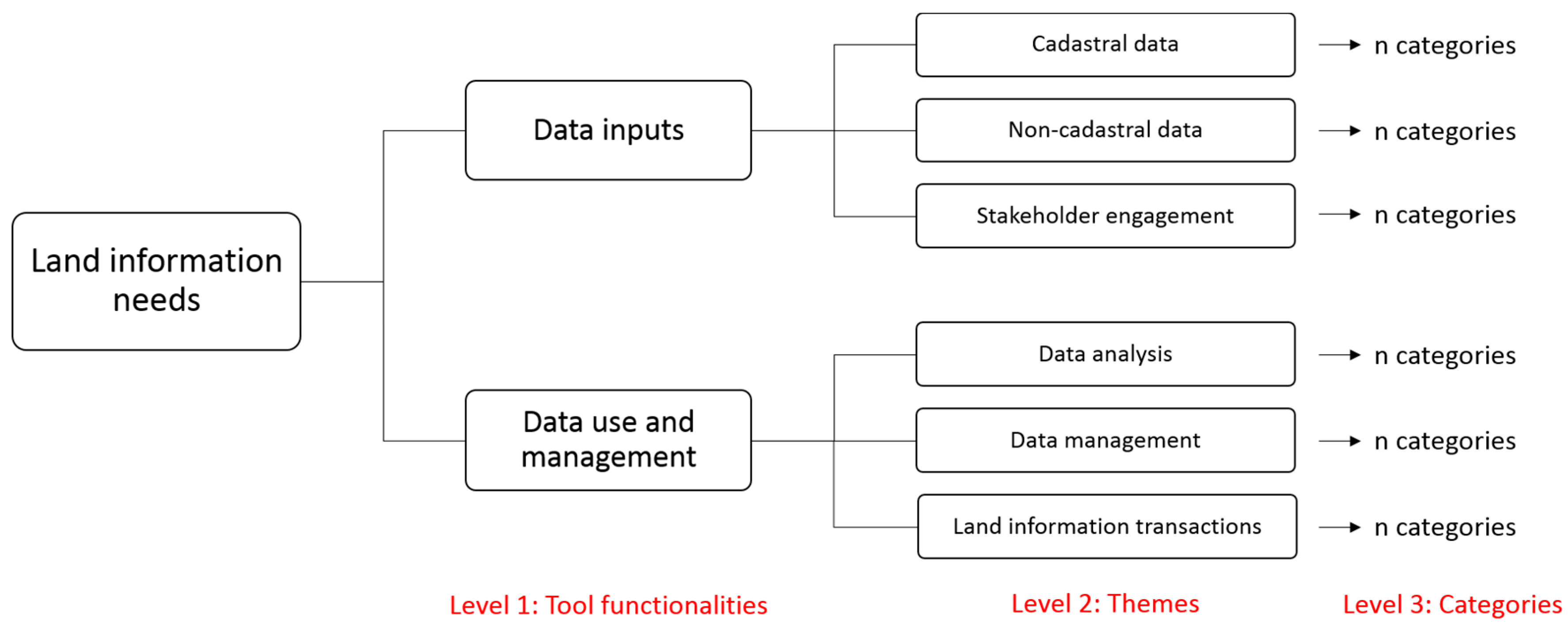
Land Information Needs: Themes and CategoriesNational GovtNational Non-GovtDistrict GovtRelative Importance *
Theme 1: Non-cadastral data54536.8%
Infrastructure2125
Land use1113
Development plans 112
Land use zone 1 1
Geology 11
Topographic data1 1
Climate1 1
Theme 2: Cadastral data43428.9%
Accurate data2114
Spatial attributes1 23
Other ownership evidence 112
Property attributes1 1
Socio-economic attributes 1 1
Theme 3: Data management53123.7%
Data accessibility 1214
Data maintenance11 2
Data ownership/availability2 2
Open source1 1
Mobile tools 11
Theme 4: Stakeholder engagement 115.3%
Consultation 112
Theme 5: Data analysis2 5.3%
Data integration2 2
* Relative importance for each dimension is calculated as the total number of code occurrences for the specific dimension as a percentage of the total number of codes recorded under the themes (n = 38).
Table 6. Overview of challenge of using NGT as a method for needs assessment in the its4land project and potential solutions.
NGT StepsNGT Challenges Experienced in ‘its4land’Potential Solutions
Silent individual idea generation in response to the presented nominal question.Inconsistent interpretation of nominal question by participantsTest nominal question with relevant stakeholders prior to workshops
Round-robin collection of ideas; clarification of ideas and grouping of non-unique ideasPaper-based recording of ideas (e.g., on post-it notes) made it cumbersome to group and clarify ideasUse a spreadsheet (if electricity and a suitable surface for projection is available)
Preliminary votePaper-based tallying of scores took quite a whileSet up spreadsheet with summing function beforehand (if electricity and a suitable surface for projection is available)
Discussion of preliminary voteNA
Final vote, listing and agreementNA
Quantitative data analysisDifficulty in comparing data quantitatively between groupsUsed qualitative data as the basis for analysis
Qualitative data analysisLoses absolute impact of quantitative outcomes around extent of consensus within the groupPreserved only in qualitative analysis. Used content analysis and frequency of code occurrences as a proxy for indicating relative importance of needs
Table 7. Overview of using NGT as a method for needs assessment in land administration.
Methodological Advantages for Land AdministratorsMethodological Disadvantages for Land Administrators
Data collectionTargets local needs and enables understanding of extent of consensus around these
  • Participatory and co-productive way of generating knowledge
  • Enables but does not guarantee, equal participation
  • Does not require much material resources
  • Relatively time efficient if groups are kept small
  • If conducted with the use of spreadsheets, research data is portable and secure
  • Simple and scalable approach
  • May not necessarily overcome group pressure to provide socially acceptable responses
  • Can be a tiring process for participants not used to providing high level of input
  • Preserving small groups may mean the need for an increased number of workshops
  • May not be able to conduct more than one nominal question per session without a substantial break
Data analysis
  • Minimal interpretation of qualitative data by researcher (at individual workshop level)
  • Simple and straightforward quantitative analysis
  • Provides a processed outcome at the conclusion of workshop
  • Difficult to synthesise and/or compare across groups—no standard method available
  • If content analysis is used to support synthesis/comparison, the absolute qualities of the quantitative data becomes lost
  • If qualitative analysis is used, researcher bias can be introduced

