1. Introduction
Urbanisation, changing population demographics, advances in technology and other major global trends are affecting every individual and organisation around the world. At the same time, public agencies are calling for a more collaborative and participative relationship with stakeholders, e.g., [
1]. Also in the field of land administration, there are calls for more integrated and user-driven land administration systems (LAS) [
2]. To date, however, most research on LAS has followed a provider-driven view, focusing on technical and legal issues such as cadastral domain models and three-dimensional property formation [
3,
4].
Traditionally, land administration organisations were created to record information about property ownership, rights and boundaries, and other attributes of real properties. This information is valuable to many parties: land and property markets require that owners can be identified with certainty, while in agriculture, forestry, urban planning, and infrastructure management, for instance, it is essential to know who owns the land on which activities are taking place [
5]. It is commonly acknowledged that LAS development has been heavily provider-driven. However, it has also been suggested that stakeholder views should be consulted in order to better understand the role that land administration can play in supporting sustainable development, e.g., [
6,
7]. With some of the recent developments such as rise of platform economies and shared processes between stakeholders within an ecosystem, there is a greater need than ever to discuss how user groups perceive their future needs for cadastral information.
Land administration is built around cadastres and land registers, or taken together, cadastral systems. It is often more meaningful to talk about cadastral systems than cadastres, as these systems describe the interaction between the identification of land parcels, the registration of land rights, the valuation and taxation of land and property, and the present and possible future uses of land [
2,
5,
8]. In the specific context of LAS, the relatively young concept of land management paradigm [
2] should not be overlooked either. Simply put, this paradigm emphasizes the role of land policies, land information and LAS in responding to sustainable development goals. The overall aim of land management is often stated as to manage land and land resources in a coherent manner. Modern land administration theory observes that “each country delivers its land policy goals by using a variety of techniques and tools to manage land and resources” [
7]. Land administration, then, is the use of these management techniques and tools in a specific jurisdiction. It has also been noted that land administration is “not an end, but a means to an end” [
9]. In other words, the implementation of land policy using land management tools should always be geared to benefit society.
United Nations Economic Commission for Europe’s (UNECE) land administration guidelines [
10] suggest that a first step in introducing a new LAS is the determination of user needs. In this article we set out to examine how to further develop LAS and how to more effectively respond to the growing gap between current and future user needs in a country that already has in place a well-developed LAS, i.e., Finland. There is a surprising scarcity of research into the uses and users of cadastral data. Most work so far has focused on technical issues such as the visualisation requirements of three-dimensional (3D) cadastral systems [
11] or the functional requirements of land information systems [
12]. Further, Todorovski and Lemmen [
13] have studied user requirements as an initial step for strategic development of cadastral services. In this study, we do not focus on the functional requirements of the Finnish land information system but rather on its content. In addition, we take a future-oriented view and discuss the needs and expectations of users in the years ahead.
From a user’s perspective, one key concept is the land information service provided by land administration [
5]. Land information service and land information system are both used to describe the subset of geographic information systems concerning data related to land records. The Finnish land information service (FLIS), which is the focus of our study here, is a service that provides (cadastral) data for both internal and external users.
We have two aims in this article. First, we want to identify the current user groups and uses of FLIS. Second, our aim is to identify the future needs, challenges, and expectations related to cadastral information. The user groups interviewed for our study comprise a diverse range of land administration functions, which should help us to gain a broad view on the subject. Ultimately, our aim and interest is to explore the potential future uses of cadastral and land information. In an earlier work on this subject, Steudler and Rajabifard [
14] point out that “a spatially enabled society will demand accurate and timely information about land”. Our own study aims to go one step further by soliciting the views of user groups about their future land information needs.
The remainder of our article is structured as follows. First, we build a theoretical framework for the study by examining the previous literature on multipurpose LAS against current trends that are bound to shape the future of land administration and surveying. Second, we describe our research design and methods. This section includes a classification of current user groups and uses of cadastral information in Finland. The third section examines different user groups’ anticipated needs and expectations related to cadastral information. We then move on to discuss the broader significance of the results and their impacts on future land administration systems. Finally, we close with some concluding remarks. Although the article is a case study on Finnish experiences, it provides useful insights for other countries with developed land administration systems.
2. Background
In this section we review two separate but complementary branches of literature: multipurpose land administration and cadastre foresight. The first is aimed at increasing our understanding of how property interests are seen and defined today, which is central to gaining a broader view of the uses of cadastral information. The second strand of literature, then, addresses the most relevant trends that are bound to shape the future of land administration systems. We also note that a large branch of literature, e.g., [
15,
16], has focused on how representations of people to land related information should be structured and organised in databases. However, given the focus of our study, we do not review these studies within this paper.
2.1. Emergence of Multipurpose LAS
Management of property interests is an established practice in many parts of the world. One of the best-known theoretical frameworks in the field of land administration is the “relationship between man and land”, see e.g., [
17], where rights are seen as property interests in terms of the owner or benefiting party and the owner’s land or resource. In this framework, the role of LAS can be summed up in terms of questions such as “Who is the owner” or “Where is the land”. During the past couple decades, this view has been challenged with an extended framework that builds on the dual nature of property interests, and that identifies both benefited and burdened parties [
7,
18,
19,
20]. The central feature of this revised framework is thus that rather than just rights, property interests refer to rights, restrictions, and responsibilities (RRRs). Williamson et al. [
7] argue that this new model better serves the needs of modern government that is concerned with sustainable land uses.
In developed countries, restrictions and responsibilities related to land and/or land resources are rapidly proliferating. Environmental protection, building standards, planning regulations, and infrastructure provision are just a few examples of land uses that are subject to increasing regulation. The common denominator in all these examples is the aim of controlling citizens’ behavior in relation to land. Enemark et al. [
2] state that changes in regulation theory present a problem for register keepers, as land administration infrastructure is often designed to manage property as a rights-based institution. Notably, there has been a marked lack of theoretical, legal, and institutional frameworks that build on the concept of property interest or RRRs [
18]. Overall, the land administration literature [
2,
6,
21] has highlighted three specific issues that may hinder the goal of sustainable land use on this front: (1) poor design of property interests, (2) poor management of property interests, and (3) lack of property interests where they are needed to control human actions.
In recent years, some progress has been made in the conceptualisation of property interests. Bennett et al. [
18] proposed a property object framework to help land administrations better understand different RRRs. They concluded that although the number of RRRs is constantly increasing, a categorisation of property objects according to five attributes (objective, action regulated, spatial extent, duration, and people impacted) can help to identify which interests are important to record. Bennett et al. concluded that only a small fraction of the total number of RRRs can be seen as “valuable enough” to be registered. Overall, they argue, “the property object is more flexible than the legal concept of a right because it is inclusive of all interests: it does not focus solely on ownership”. It is on this basis that they decide to address the lack of theoretical frameworks designed to support RRR management.
Kalantari et al. [
20] partially address the same issue by proposing a cadastral data model that is based on modern land administration theory. They argue that the physical parcel-based data model should be replaced by a spatially referenced data model that is based on the legal property object. This, they maintain, would facilitate the incorporation of a wide range of RRRs into a LAS.
It has also been pointed out that new property interests are increasingly mapped and managed outside LAS and cadastral systems [
19]. This may give rise to several problems, including delays in decision-making and inefficient administration. The solution suggested by Bennett et al. [
19] is an eight-step land administration toolbox for the creation and administration of RRRs. They stress that these tools are applicable to all land-related RRRs. In line with modern land administration theory, land policies underpin all other land administration activities in this framework. Legislation, flexible tenures, institutions, spatial data infrastructures, and capacity building are presented as complementary components that are essential for good land administration [
19].
So what can we learn from this framework? The goal of developing a holistic and systematic approach to the management of new (as well as “old”) land interests is of course, ambitious to say the least. The framework is obviously useful only if a shared understanding is first achieved for the integrated management of RRRs. Also, as the authors themselves point out, the toolbox concept is constantly evolving and should be adjusted to reflect the development of technologies and administrative practices.
Despite the growing body of literature on universally ideal land administration practices, there is still no clear answer to the question as to what elements should be included in a LAS. There is a fairly broad consensus that every society should design its systems and select the appropriate elements according to its own needs and stakeholder expectations. Another common statement about country differences is that LASs have evolved under different legislative and cultural environments (e.g., [
8]). Enemark et al. [
2] point out, however, that the constraints of local history are diminishing under the new era of unified visions that address global drivers such as globalisation and technology development. Indeed, it would seem that a more holistic and global outlook is gaining popularity among land administration experts.
2.2. Future Directions for Land Administration and Cadastral Systems
One viewpoint is that the changes that have taken place in LAS are driven by the evolution of people-to-land relationships [
22]. Williamson et al. [
7] describe three other dimensions of LAS dynamism: evolving information and communications technology (ICT) and globalisation, the dynamic nature of information within LAS, and changes in the use of information. Our focus in this article is on the latter dimension, i.e., changes in information use. In order to tackle this issue it is necessary to have at least some understanding of the operating environment and its projected development.
Active exploration of future directions is a relatively established tradition in the field of land administration and surveying. The International Federation of Surveyors (FIG) has published several reports that envision the future of cadastral systems [
21,
23]. National mapping agencies and land registers have also shown a growing interest in building country-specific strategies to develop their own cadastral systems [
24,
25]. Although the scope and time horizon of these publications vary from case to case, they all seek to explore the possible directions in which cadastral systems might evolve in the future. Preparing for the (un)expected changes in the operating environment is clearly considered important both for national and international organisations and their strategy work.
Some commentators [
22,
26,
27] have sought to anticipate future trends in development by examining an array of “global drivers of change” in the context of cadastral systems. Most of these studies are based on the common notion that global drivers are changing the way that humankind relates to land, which in turn should lead to considerations about the actuality of cadastral systems. The analysis of future trends is thus one possible starting point for re-engineering future land administration systems.
A review of the scarce literature on cadastre foresight [
22,
23,
26,
27,
28] highlights a few drivers over others. On a global scale, urbanisation, globalisation, sustainable development, and advances in information technology have been singled out as the most dominant drivers for cadastral systems [
22,
23]. All these trends are bound to influence government land administration policies, models, and infrastructures. Urbanisation, for instance, is leading to intensified land use in urban areas, which from a cadastral point of view will increase the need for three-dimensional land information and the ability to manage more complex property interests. Moving from a global to a local, Finnish perspective, the expected forces of change become more technology-oriented [
26]. This is hardly surprising, as future possibilities and challenges are perceived differently in countries where land tenure remains outside formal governance arrangements. In these countries, greater emphasis is given to humanitarian needs such as food security and clean water provision, rather than technological advances.
Trend studies and analyses are obviously time-dependent, and to some extent bound to a specific geographical area. Basic land administration functions, however, vary less over time and space. The land administration literature identifies four main land administration functions: land tenure (managing rights in land), land value (valuation and taxation of land and properties), land use (planning and control of land use and land resources), and land development (implementing utilities, infrastructure and construction planning) [
2]. Together, these functions ensure the proper management of RRRs. The key question is whether LAS providers need to modify their current infrastructures with the changes that are bound to happen in the operating environment in the decades ahead. Williamson and Ting [
22] argue that it is necessary to consider three related perspectives when implementing a change in land administration. The first is to acknowledge the global drivers of change, as described above. The second is to weigh the impact of these drivers on the design of LAS and its cadastral component. The third perspective, then, is the implementation phase, where the focus is on technical and administrative tools that support the trends and development.
It is important not to overlook the anticipated impacts of the global drivers described by Krigsholm et al. [
26]. It is projected that the emergence of new business ecosystems will create shared processes and new forms of collaboration in land administration. This in turn will require greater knowledge about stakeholders and user groups, particularly about how they perceive the future of their own industry and the need for cadastral information. In the literature on multipurpose LAS, interoperability and the growth of interests in land are identified as the major obstacles to development [
20]. This, in itself, can be read as an imperative to better understand the changes in the use of cadastral information.
3. Study Design
3.1. Methods of Data Collection
In this study, our focus was to examine the fourth dimension of LAS dynamism–changes in information use—in the Finnish context. To this end, we designed a two-stage research approach. In the first stage, we identified and defined user groups that regularly use FLIS. Then, we proceeded to examine these groups in more detail in order to better understand their roles as users by conducting short, 10–30 min telephone interviews with one or more representatives of each group.
In the second stage, we conducted semi-structured interviews with prominent user groups, focusing on future needs and expectations related to cadastral information. These interviews lasted 40–60 min and were carried out in December 2017–February 2018. Semi-structured interviews provide a flexible enough method for our purpose, since we aim towards understanding diverse perspectives and perceptions on changing uses of cadastral information. By definition, this interviewing technique offers a focused structure for the discussion, but also enables a further exploration of the research topic [
29]. Each interviewee was presented with the same questions in order to steer the discussion in the intended direction. First, we asked the interviewees to say how the content of FLIS corresponds to their organisation’s needs in order to achieve a deeper understanding of the current state. Next, we asked them to identify the changes that they thought were shaping their respective industries, followed by a discussion of the possible impact of these changes on cadastral information. The interviews were recorded and the researcher took notes that were later complemented based on the records. Thematic analysis [
30] was used to identify key categories that summarised the interview data. We present the findings for the second stage in the fourth section below.
3.2. Case Finland: User Groups and Their Use of Cadastral Information
In this section, we describe the current range of users and applications that FLIS serves, and thus address our first research aim. As mentioned earlier, FLIS is the main deliverable of the Finnish cadastral system. The FLIS is divided into two parts: the cadastral part contains basic information on cadastral units, including their identification number, size, and location, as well as commons, information on land use planning and restrictions on building, and a cadastral map. In addition, easements and other use rights are available in the cadastral part. The land register part includes titles, mortgages, and other personal rights concerning real properties [
31]. The establishment, content, and maintenance, as well as the handover and use of FLIS information content is regulated by law.
From a maintenance point of view, this means that the National Land Survey (NLS) has a legal responsibility to ensure all data provided through the system is up-to-date. The Act on the Land Information System and Related Information service (2002/453) [
32] also provides detailed provisions for the handover and use of FLIS data. The basic information concerning private property is available for the owner of the property without a fee. However, extracts from the registers are subject to a charge. For private companies, the NLS offers service through FLIS in REST/WFS formats for a charge. For governmental agencies, these services are free. It is the responsibility of NLS to monitor that all information use follows the provisions of law.
Identifying the current and potential future users of land information services is nevertheless difficult as new uses are continuing to emerge and old ones disappearing on a regular basis. Todorovski and Lemmen [
13] make a distinction between external and internal cadastral data users. In this study we chose to focus on external users only, which meant that land surveyors working for the government, for instance, were excluded. We started by dividing external users into two groups: authoritative and non-authoritative users. Further, we identified a total of 19 user groups of FLIS and assessed their “importance” based on so-called key user group status (
Table 1). The final list was compiled in consultation with NLS experts who worked closely with FLIS users.
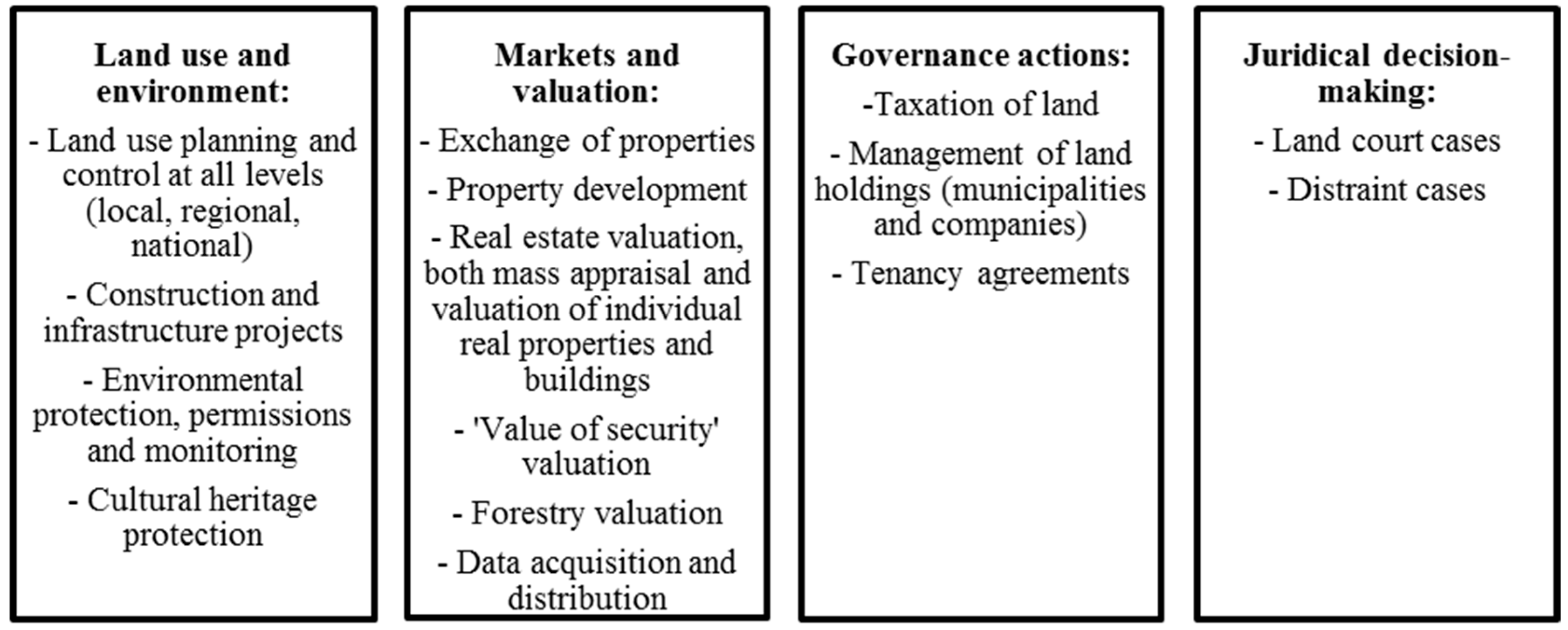
Next, we contacted all identified user groups and asked them to define (1) the purpose for which they used FLIS content, (2) their methods of content use and the significance of FLIS content in their own work. We used this information for two purposes. First, we further categorised the purposes of data use under four themes (
Figure 1). To this end, we took into account the fact that often the aim of (multipurpose) LAS is to support sustainable development in its four dimensions: environmental, economic, governance, and social. These dimensions should ideally be reflected in the purposes of use. The recognised themes of FLIS usage are (1) land use and environment, (2) markets and valuation, (3) governance actions, and (4) juridical decision-making.
Figure 1 shows some examples of more specific uses for each dimension. Second, we also used this information to recruit interviewees for the semi-structured interviews.
Furthermore, we collected some basic information on how user groups searched and extracted the information that they thought was relevant to themselves. Most user groups said they used an online portal to which they had purchased a limited number of access permits from NLS. Tax Administration, the Population Register Centre, and some other organisations additionally received some data via automatic transfers. Data on all established as well as expired real property units, for instance, was obtained via this route.
It may well be difficult for users to articulate, let alone quantify the direct benefits of cadastral information. Traditionally, the main function of the cadastral system has been to manage land rights in order to support security of tenure and effective trading. The answers we received suggest that this so-called land market function is very much predominant in current FLIS use, too. Many user groups stressed that they needed reliable information on who owned a given real property or held rights of use. In the banking sector, for instance, it is impossible to verify the value of security without documentation of registration of title and easements. The infrastructure and energy sector provides another example of the significance of ownership and other property rights. Often such projects are aimed at minimising losses for landowners (e.g., land acquisition, changes to the landscape). In order to find the optimal and technically most feasible solution, landowners are encouraged to share their opinions during the preliminary phase of planning—but this goal cannot be achieved without reliable information of current real estate division and property right holders.
4. Findings: Relevant Changes from the FLIS User’s Point of View and Their Implications for LAS
Based on our findings, we identified six broader society-level changes that users thought had a major impact on their uses of cadastral data. Our analysis was specifically aimed at identifying definite and probable changes that were foreseeable for the user groups at time of the interviews. We also sought to establish the possible implications of identified changes to LAS. Our findings are summarised in
Table 2. Direct excerpts from interviewees’ responses are given in italics. In order to cover all the uses described in the previous section, our second-stage interviews were conducted with representatives of the following user groups: the Population Register Centre, the banking sector, construction and infrastructure companies, Regional State Administrative Agency, municipalities, real estate consultancies, and the Tax Administration.
Streamlining the environmental permit procedure is expected to have a major impact on the provision of environmental services. An interviewee representing the Regional State Administrative Agency said that “the focus will shift from the processing of environmental permits to monitoring (protected) areas”. This is also going to impact the need for cadastral information as the current environmental permit process requires that landowners and other concerned parties are informed. This means that the main deliverables of FLIS in which the Regional State Administrative Agency is currently interested relate to the ownership of real properties in the area in question. Monitoring is less demanding in terms of the notification procedure, and the obligation to inform is less extensive. In the future, therefore, it is possible that the Regional State Administrative Agency may have a reduced need for cadastral information.
Integration of public services was another change recognised and mentioned by an interviewee from the Regional State Administrative Agency. Over the next few years, all government functions related to the environment and land use will be concentrated under one agency, which presumably will lead to job restructuring and streamlining. This means that civil servants will probably find themselves handling cases even from the other side of the country. This means it will be crucial to have access to high-quality aerial photo material. Historical information from the area, again in the form of aerial photos, would also be beneficial. In the case of environmental permits for the peat extraction industry, for instance, it is useful for the official handling the permit application to see when production has initially started. In the case of the integration of public services, then, the LAS implication is an increasing demand for temporal cadastral information and especially aerial photo material.
3D land use planning is one application of 3D technologies that have developed rapidly in recent years. For planning purposes, 3D representations make the original two-dimensional drawings easier to visualize. The specific use of cadastral information depends on the level of planning (detailed plan, master plan, regional plan), but the principal use is for the purpose of informing landowners and other concerned parties. In some instances, it is also important to be able to locate usufructs and easements on the drawings. A natural implication here is that the planner would like to have access to a graphical 3D representation of land register and cadastre data as well.
Tightening banking regulations in the Euro area, according to an interviewee representing the banking sector, are a clear and predictable change factor. In essence, this means tighter solvency requirements for banks. As the core business of commercial banks is to lend money to individuals who often use their flats or properties as collateral, it is crucial to have accurate and reliable information about deductible objects/values of security. Banks will therefore require up-to-date and reliable information from FLIS to help them determine the collateral competence of real properties. Also, for purposes of collateral appraisal in general, banks will increasingly require a higher level of integration among public data registers. Banks currently collect information from several sources (e.g., FLIS, apartment register, forestry societies) to manage and appraise security values with adequate precision. The linkage of tightening banking regulations with real estate appraisal naturally means that real estate consultancies and other operators that provide appraisal services must also meet the new requirements. It is expected that the data needs of this user group will evolve closely in line with the needs of the banking sector.
Digital services were identified as an industry-shaping force by several authoritative and non-authoritative user groups. For authoritative user groups, the growth of digital services appears in the form of e-government and the provision of online public services to citizens. As an interviewee representing the Tax Administration said, “… our aim is to dispense with paper mail to our customers and to provide high-quality electronic services. Another goal is to achieve a high level of automation”. For non-authoritative user groups, the continuing expansion of digital services similarly means the provision of online services and increasing the level of automation in service processes. When environmental permit applications are submitted via an online portal, for instance, it is important to be able to link relevant information from other sources, including FLIS, to the application. The e-application should also self-update automatically so that when processing begins, all information is correct and up-to-date. Further, for the Tax Administration, the lack of up-to-date planning information is an obvious hindrance for effective real property taxation and digital service provision.
Increasing data transmission between public data agencies was another change recognised by authoritative user groups. It is important for the tax authorities, apartment register authorities, and land administration authorities, for example, to work closely together on issues around real property taxation. This co-operation includes the transmission of data from one agency to another. One of the biggest problems in data exchange stems from differences in terminology and basic units, which makes it particularly challenging to allocate data to the appropriate units. Another point raised in several interviews was the importance of following and benchmarking the efforts of other authorities to develop their data production. Some made the comment that they did not want to be in the forefront themselves, but preferred to follow the lead of others in developing news processes.
Overall, we found that the six themes identified in this study were in line with previously recognised forces of change for the operational environment of cadastral systems: development of ICT technology, urbanisation, globalisation, to mention a few. In the
Table 2 column ‘Implications to LAS’ we raised some examples on how the user groups perceive implications of these themes to LAS. In general most of the implications seem rather small and detailed but with a closer examination they propose many alterations to the current system. We continue this discussion in next section.
5. Discussion: Land Administration Response to Future Needs and Expectations
Cadastral information is certainly not going to diminish in importance in the future. Core user groups of Finnish LAS expect to continue to need information for instance about the registration of title to a property. The challenge for cadastral data provider lies in how this information can be provided reliably, accurately and in real time. It is clear from our results that users of cadastral information in Finland are genuinely and deeply concerned about these kind of issues. Our finding is consistent with the ongoing transition towards a data-driven society: it is estimated that over the next few years, we will be generating more data than in the entire history of humankind [
33]. Most, if not all industries and processes will become increasingly data-dependent, and it is imperative that land administration agencies are in the position to respond to these changes.
Land and property information is customarily seen as spatial information: by definition, the cadastre provides geographically referenced information about units of land. Now, growing importance is being attached to capturing the dynamic nature or the fourth (time) dimension of land information [
34]. In addition to theory and data model building, some work has been done to elaborate practical implications. In Germany, for example, the current view seems to be that time-related cadastral information is mainly required for purposes of urban, environmental, and cultural heritage monitoring, as well as for spatial planning [
35].
Our findings stress that the temporal aspect is more important to certain user groups than others. Tax decisions, for instance, are made once a year, which means there is less pressure and demand on the time dimension of cadastral data. For the tax authorities, the priority is to have access to accurate information for a specific fixed date. On the other hand, parties involved in planning and valuation processes as well as in environmental monitoring indicated that they would benefit from the change information. Interestingly, we found that one of the main drivers of the need for temporal land and property information might be the integration of public services, in other words, economic rationalisation. Although our study highlights the relevance of this issue to public environmental services, it is reasonable to expect that other industries will experience similar pressures in the years ahead.
Expectations regarding the accuracy and dynamism of information are putting great pressure on the development of the land information system. For many industries, public data agencies, and private enterprises, it is also increasingly important to be able to combine cadastral information with other data sources. This means that users also expect to receive cadastral information in a more customised format. But is it the duty of a public servant to tailor information according to the user’s specific requirements? To be able to answer this question the first challenge for the land administration authority is to define its own role: is it a service provider or something else?
Related to the above, Larsson [
36] highlighted the need for constructive action to co-ordinate land information systems, pointing out that governments must define their functions and responsibilities for certain types of information, and specify how the exchange of information is organized among different government actors. Co-ordination has thus been a long-standing concern in the land administration literature. Our study adds a further dimension to this discussion by demonstrating that even actors outside government emphasize questions related to the exchange of information. The core fundamental questions, however, remain the same—despite the rapid advances seen in ICT and related technologies, we are still looking for the same improvements as two or three decades ago.
In recent years there has been a steady growth of interest in using 3D technologies and information to improve the management of land and property [
37]. There has been some discussion about the main beneficiaries of 3D cadastral information, albeit more in the context of developing and lower-income countries [
38]. Griffith-Charles and Sutherland [
38] present that positive impacts of 3D for businesses could come from more accurate measurements on all relevant dimensions or improved visualisation. More recently, a public value perspective of 3D geoinformation has been explored by Ho et al. [
39], with a conclusion that “a clear obvious need for 3D geoinformation that responds to a specific societal challenge” is still missing. In our study, larger municipalities, the apartment register authority, and construction and infrastructure companies in particular identified 3D cadastral information as an important data asset of the future. The apartment register authority, however, commented that they will only consider the utility of 3D representation for their own purposes once the land administration authority has made the transition. In our study, we were not interested to examine the benefits of 3D cadastral information, and we also excluded many other important aspects such as the increasingly complex structures of high-rise buildings and the difficulty of registering them.
One of the established goals of LAS is to support e-governance [
7]. The silo or sector-by-sector approach is a well-recognised problem for e-government [
40]. The UN report [
40] also points out that policy makers need “a holistic vision to sustainable development that emphasises synergies among various sectors and approaches that will help advance economic sustainability and social equity”. According to our findings, user groups of FLIS and especially other public agencies are well aware of this problem. Addressing the silo problem of Finnish e-government is beyond the scope of this study. We can, however, state that users of cadastral information pay attention to issues such as the interoperability of government services and would prefer to see a more coherent system of public data functions. As data exchange and sharing is bound to increase in the future, interoperability and data exchange—or rather the lack of them—are expected to become more serious issues for LAS providers.
Given our concern in this study with several different actors with different and sometimes even competing interests, one may well ask whether these conflicting views distort the analysis and the conclusions drawn from the analysis. The main goal of our study was to establish the relevance of cadastral information from a user group perspective. We did not give more weight to any single user group over others. Furthermore, the implications that we observed were complementary rather than contradictory. It is also noteworthy that our aim was to generate information that supports the development of the system (LAS) rather than the development of surveying and/or cadastral services. The latter has been covered among others by Heo [
12], and Todorovski and Lemmen [
13], who focus more closely on identifying user requirements—a critical step in service and product development. A comparison of our setting with these studies highlights the fact that both these topics require reaching towards the end users of cadastral information, but in our study we were more interested in broader changes and their implications for the use of cadastral information.
Will land administration systems be able to provide what user groups require in the future? This is the central question we have addressed in this paper. To sum up our findings, we observe that from the user point of view that the future land administration system should be at least: (1) dynamic and responsive, (2) interoperable (easily accessible by other technologies and applications), and (3) coordinated with other public data registers. The first and second observations are more technical in nature and have in fact been widely discussed in the land administration literature. The third observation is more policy-oriented and calls for further actions outside the limited scope of land administration. Although it is important to understand the function and wider role of cadastral information, the only way to achieve better outcomes on the level of society is via better coordination between public data agencies.
6. Conclusions
Land administration systems have long served in the role of recording transactions, but in today’s society, that role has expanded and is continuing to expand. Our findings showed that although it is possible to see other dimensions of cadastral data use in Finland, the land market component is clearly the predominant factor for user groups. Ownership and property rights not only secure investments and transactions, but also support taxation, environmental protection, and other public functions. User groups believe that this kind of information will remain important for their own work in the years ahead. However, it is evident that compared with some other countries that have German-style cadastral systems, FLIS in Finland has a rather narrow content. In Sweden, for instance, the country’s comprehensive real property register includes several sub-registers such as an address register, building register, and plan register. None of these are integrated into the Finnish cadastral system, the origin of FLIS content.
It is imperative for all organisations, including national land administration agencies, to keep up with the pace of change in the operating environment. Furthermore, a shift from an administrator to a user point of view can open up valuable insights into future expectations regarding land and cadastral information. This should be kept in mind, especially when considering the long-term strategic development of national land administration systems. In spite of the apparent need for more and more in-depth information about user perceptions, there is still a scarcity of literature around this topic. In this paper, we have addressed this gap by exploring the user point of view in the context of the Finnish land administration system. Our findings suggest that user groups increasingly expect cadastral information to be easily accessible and up-to-date, as well as compatible with data from other sources.
Based on the brief glimpse that we have gained here into user viewpoints, it is apparent that more research is needed into the ways in which the administrative side can respond to these emerging expectations. Some of the anticipated changes could even be interpreted as future requirements, or from a different angle as inputs that can be used as part of business and ICT strategies. Data standardisation models and legislation, for example, should be redesigned to be adaptive enough to face the future needs and expectations of different groups of cadastral information users. Moreover, if LAS administrators want to maintain their relevance, it is important that they continue to communicate with current and potential user groups. After all, it is not possible to properly understand the evolution of a (land administration) system exclusively from a top-down, register authority’s viewpoint.
There are a few limitations in our study that should be kept in mind with regard to the applicability and reliability of our findings. First, only a subset of user groups was included in our thematic interviews where we discussed future needs and expectations. This obviously excludes some potentially interesting and important viewpoints on the topic, and makes our findings partial and susceptible to bias. Second, our empirical data comes from one country only, and that country has a high-quality and reliable LAS in place (see e.g., [
41]). Even though the land administration literature has shown a tendency towards more universal guidelines in determining the key ingredients of LAS, it is important not to neglect the country-specific details, starting with the definition of cadastral system and cadastral information. In Finland, information on buildings and land values are maintained by other authorities, which is not the case in some other countries. Third, it is important to note that our study explored only one source of LAS dynamism, i.e., changes in the use of information.
Although we designed our research with care, we have only scratched the surface of potential emerging uses of cadastral information. It seems far too simplistic to suggest that cadastral data use will remain static in the future. Although it is possible to argue that the changes will be subtle and even slow as many parties that use cadastral information are under strict regulatory control, we are living in a world today where disruptive changes can reach even more conservative sectors.


