Article

Impact of Soil Depth and Topography on the Effectiveness of Conservation Practices on Discharge and Soil Loss in the Ethiopian Highlands

by
Adugnaw T. Akale
1,
Dessalegn C. Dagnew
2,
Mulugeta A. Belete
1,
Seifu A. Tilahun
1,
Wolde Mekuria
3 and
Tammo S. Steenhuis
1,4,*
1
Faculty of Civil and Water Resources Engineering, Bahir Dar Institute of Technology, Bahir Dar University, P.O. Box 26, Bahir Dar, Ethiopia
2
Institute of Disaster Risk Management and Food Security Studies, Bahir Dar University, P.O. Box 5501 Bahir Dar, Ethiopia
3
International Water Management Institute (IWMI), East Africa and the Nile Basin Sub-Regional Office, P.O. Box 5689, Addis Ababa, Ethiopia
4
Department of Biological and Environmental Engineering, Cornell University, Ithaca, NY 14853, USA
*
Author to whom correspondence should be addressed.
Submission received: 12 September 2017 / Revised: 29 October 2017 / Accepted: 31 October 2017 / Published: 3 November 2017

Abstract

:
Restoration of degraded landscapes through the implementation of soil and water conservation practices is considered a viable option to increase agricultural production by enhancing ecosystems. However, in the humid Ethiopian highlands, little information is available on the impact of conservation practices despite wide scale implementation. The objective of this research was to document the effect of conservation practices on discharge and sediment concentration and load in watersheds that have different soil depths and topography. Precipitation, discharge, and sediment concentration were measured from 2010 to 2012 in two watersheds in close proximity and located in the Lake Tana basin, Ethiopia: Tikur-Wuha and Guale watersheds. The Tikur-Wuha watershed has deep soils and a gentle slope stream channel. The Guale watershed has shallow soils and a steep slope stream channel. In early 2011, the local community installed upland conservation measures consisting of stone and soil bunds, waterways, cutoff drains, infiltration furrows, gully rehabilitation, and enclosures. The results show that conservation practices marginally decreased direct runoff in both watersheds and increased base flow in the Tikur-Wuha watershed. Average sediment concentration decreased by 81% in Tikur-Wuha and 45% in Guale. The practices intended to increase infiltration were most effective in the Tikur-Wuha watershed because the deep soil could store the infiltrated water and release it over a longer period of time after the rainy season than the steeper Guale watershed with shallow soils.

Graphical Abstract

1. Introduction

Soil erosion is a serious global environmental problem and constrains food production for the increasing world population [1]. Erosion is a natural process that is enhanced by human activities. It causes the loss of agricultural productivity and a decline of water quality [2,3,4]. It is estimated that about 10 million ha of cropland is lost in the world due to soil erosion every year [5] and is often a common occurrence in the Mediterranean and China [6,7]. Erosion rates vary throughout the world: In the hilly areas of the northern Mediterranean region, along the Atlantic coastline and stretching from France to Greece, the annual sediment losses are in the order of 1.5 Mg ha−1 y−1 [8]. USDA estimates that the average erosion rate in 2010 was 6.7 Mg ha−1 y−1 overall cropland in the United States, while the average erosion rate for pastureland was 0.4 Mg ha−1 y−1 [9]. The total sediment load of the Yellow River in China is 1.6 billion Mg y−1 or 20 Mg ha−1 y−1 [7].
Severe erosion is also a problem in the Ethiopian highlands, where nearly 1.5 to 2 billion ton y−1 soil loss is reported [10,11,12]. The Blue Nile River alone transports over 130 Tg y−1 (million tons) of sediment per year (or 7 Mg ha−1 y−1) [13]. Fifty-eight percent of the Chemoga watershed, a part of the Blue Nile basin in Ethiopia, lost more than 80 Mg ha−1 y−1 of soil [14]. About 39% of the Blue Nile basin area contributed more than 30 Mg ha−1 y−1 of soils [15]. Based on the findings of [16], upland soil losses in the Lake Tana basin of the Blue Nile were 30 Mg ha−1 y−1 on average, most of which was deposited on the plains around Lake Tana. Similarly, in the Koga watershed of the Lake Tana basin, 45% of the watershed is vulnerable to soil erosion [17]. Sheet erosion from the Gilgel Gibe catchment area, in southeastern Ethiopia, is estimated to be about 45 Tg y−1 [18].
Most of the factors contributing to high soil erosion rates and land degradation are human induced [15,19]. To meet the increasing demand for food and fuel by the rapidly growing population, the land has been deforested and the subsequent loss of organic matter has led to a lower soil aggregate strength and finer soils. As a result, sediment concentrations have increased in the runoff water, greatly increasing the natural rate of hardpan formation. The hardpan is a typical characteristic of degraded soils [20,21]. While the hardpan affects the watershed hydrology by restricting the downward water movement, the surface soil remains highly permeable and has infiltration rates greater than the prevailing rainfall intensity. Thus, surface runoff in the degraded watershed mainly occurs when the soil is saturated by either a perched water table above the hardpan or by regional high ground water in the valley bottoms [16,21].
To mitigate the effects of land degradation, local communities and international donors have been implementing conservation practices since the 1980s [22]. Starting in 2010, the Ethiopian government intensified its effort to improve agricultural production by forcing farmers to install soil and water conservation practices for two months per year [23]. Annually, more than 15 million farmers contribute free labor [24].
In addition to government-led programs, conservation programs were implemented with foreign donor money. One of these programs is the Tana Beles Integrated Water Resources Development Project (abbreviated as Tana Beles Project) funded by the World Bank, which improved 80 watersheds in the Lake Tana basin in collaboration with the community. Our study was carried out in two of these watersheds.
The effect of conservation practices on the hydrological response of runoff and sediment in the Lake Tana basin is not well studied. The studies that have been carried out in the Lake Tana basin focused on modeling the sediment load, lake level fluctuation and water balance, and runoff volumes and identifying the erosion hot spot areas, analyzing runoff processes through conceptual hydrological modeling, and hydrological and suspended sediment modeling [3,16,25,26,27]. Studies outside the Lake Tana basin found that infiltration furrows decreased direct runoff and sediment load but not sediment concentrations in the first three years of observation when gullies were present [23,28,29]. Another study 200 km south of Lake Tana [30] found that the long-term impact of conservation practices was minimal. None of these studies related the effectiveness of the conservation practices to watershed characteristics. The latter is important for prioritizing watersheds for the implementation of conservation measures. The objective of the study is, therefore, to examine the effects of watershed characteristics on the sediment and runoff reduction rate after soil and water conservation implementation. The two agricultural watersheds, Tikur-Wuha and Guale, were chosen from 80 watersheds rehabilitated by the Tana Beles Project, where in the same year (2011), soil and water conservation practices were installed by the communities and discharge, sediment, and rainfall data was available before and after implementation. In addition, these two watersheds were in close proximity and had the same soil type but were different in soil depth and topography.

2. Materials and Methods

2.1. Description of the Study Area

Both Tikur-Wuha (38°05′25″–38°06′45″ E–W; 11°48′22″–11°49′26″ N–S) and Guale (38°08′19″–38°09′19″ E–W, 11°45′18″–11°46′41″ N–S) watersheds are located in the headwaters of the Ribb watershed (Figure 1). The Tikur-Wuha watershed is 500 ha (Figure 1c,e) and the Guale watershed is 190 ha (Figure 1d,f). Slightly more than half is cropland (Table 1). The Ribb is one of the main tributaries of Lake Tana, which is the beginning of the Blue Nile. The climate can be characterized as humid monsoonal. The warmest month is April with an average temperature of 16.5 °C in January and the coldest is 13.3 °C in July. The annual average rainfall is around 1600 mm y−1 with the major portion falling in the rainy phase from May to September.
The soils are of volcanic origin and classified as Chromic Luvisols [31]. A soil depth map was developed for the two watersheds based on the soil pits excavated for the three slope positions by the Tana Beles Project. The slope at the soil pit location was determined from a digital elevation map. Soil depth was assigned to the slope categories and soil depth maps were created using ARC GIS. Based on observation from soil pits, the Guale watershed depth has a shallower soil depth than the Tikur-Wuha watershed (Figure 1e,f). In the Guale watershed, 20% of the soil is less than 15 cm, 41% has a depth of 15 cm, and only 39% of the soil is 25 cm deep (Figure 1e). In the Tikur-Wuha watershed, soils are much deeper with 12% of the soils being less than 25 cm deep and the remaining area soils being 55 or 90 cm deep (Figure 1f). Gullies occupied slightly less than 1% (or 4.2 ha) of the Tikur-Wuha watershed and just above 1% (or 2.4 ha) in the Guale watershed (Table 1). They were 3 m deep on average and were primarily found in the valley bottom areas that become saturated during the rainy phase.
A 30 m × 30 m digital elevation map made by the Shuttle Radar Topography Mission (SRTM) was available for both watersheds. The elevation of Guale watershed ranges from 2685 to 2859 m and Tikur-Wuha watershed from 2870 to 3298 m (Figure 1c,d). Regarding the channel slope, the Guale watershed channel slope (11%) is steeper than the Tikur-Wuha watershed (5%). The profile curvature (defined as the curvature of the surface in the direction of steep slope with respect to the vertical plan of flow line) of both watersheds is shown in Figure S1. A large portion of the Guale watershed has a negative profile curvature (Figure S1a), whereas in the Tikur-Wuha watershed, a large portion has a positive profile curvature (Figure S1b). This means that the Tikur-Wuha watershed is concave with decreasing slopes towards the outlet (Figure S2a). Soil will be deposited in the center of the watershed forming deep soils that can store water (Figure 1f). On the other hand, the Guale watershed has a convex slope with increasing slopes towards the outlet (Figure S2b). Erosion is therefore dominating sedimentation resulting in shallow soils with very little water storage (Figure 1e).
The two watersheds had a similar land cover with slightly more than half represented by cropland. Wheat, barley, and potato are mainly grown. Approximately a quarter is in forest shrub and woodland, 10% is bare, and 10% is grassland (Table 1). The main differences between the two watersheds are the slope and depth of soils (Figure 1e,f, Table 1). This is also the reason that the grazing land is larger in the Tikur-Wuha watershed where, due to the flatter slope, a larger portion of the bottom area is saturated and is thus too wet for crops and is used for grazing instead.
In 2011 and 2012, soil and water conservation practices were installed in the two watersheds by watershed committees under the auspices of the Tana Beles Project (Table 2). The village watershed committee for each watershed, consisting of six female and six male members, was established in 2010 with the responsibility of facilitating implementation of soil and water conservation from planning to actual implementation. Members of the committee were first trained in SWC design and construction by the Tana Beles Project, and then, in close consultation with the community, made a tentative watershed conservation plan with preference for the installation of soil and water conservation practices aimed at increasing dry season baseflow and reducing the sediment load from the upper catchment.
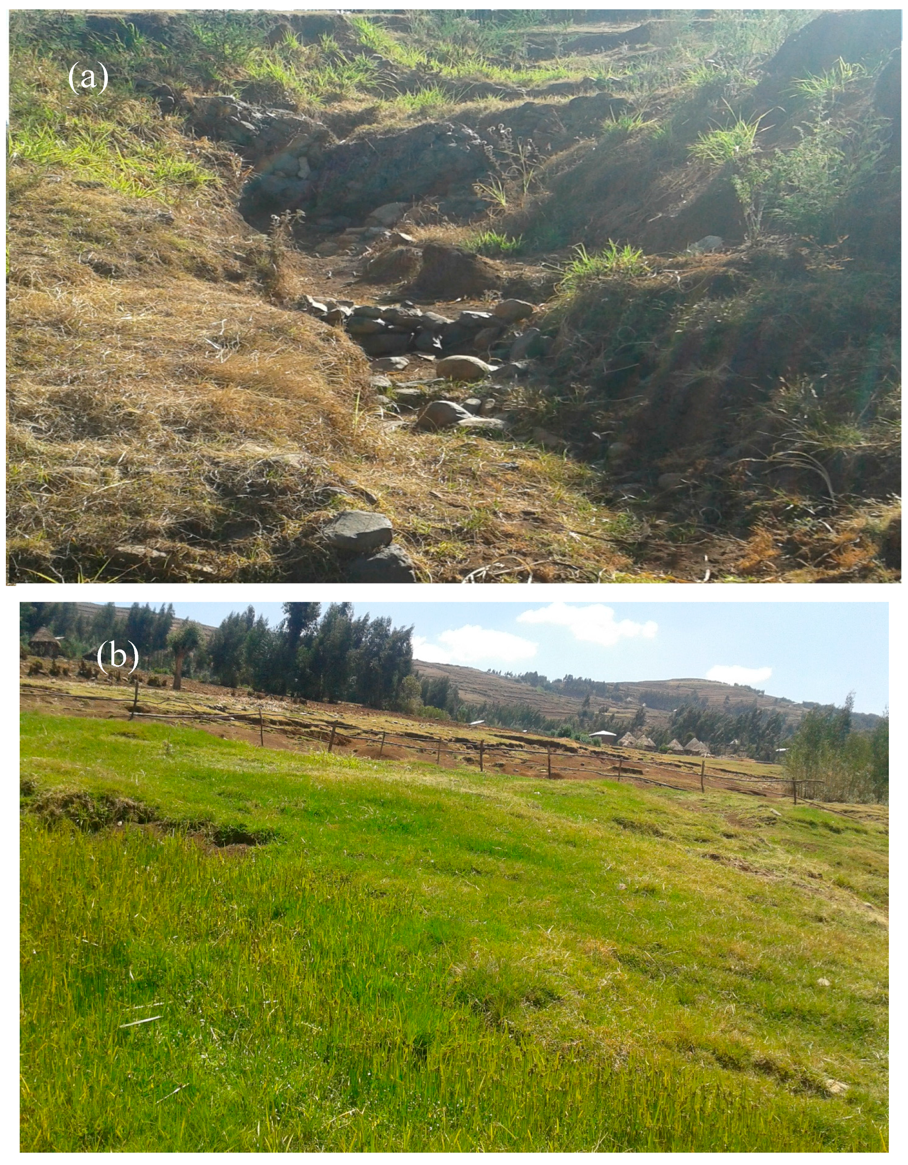
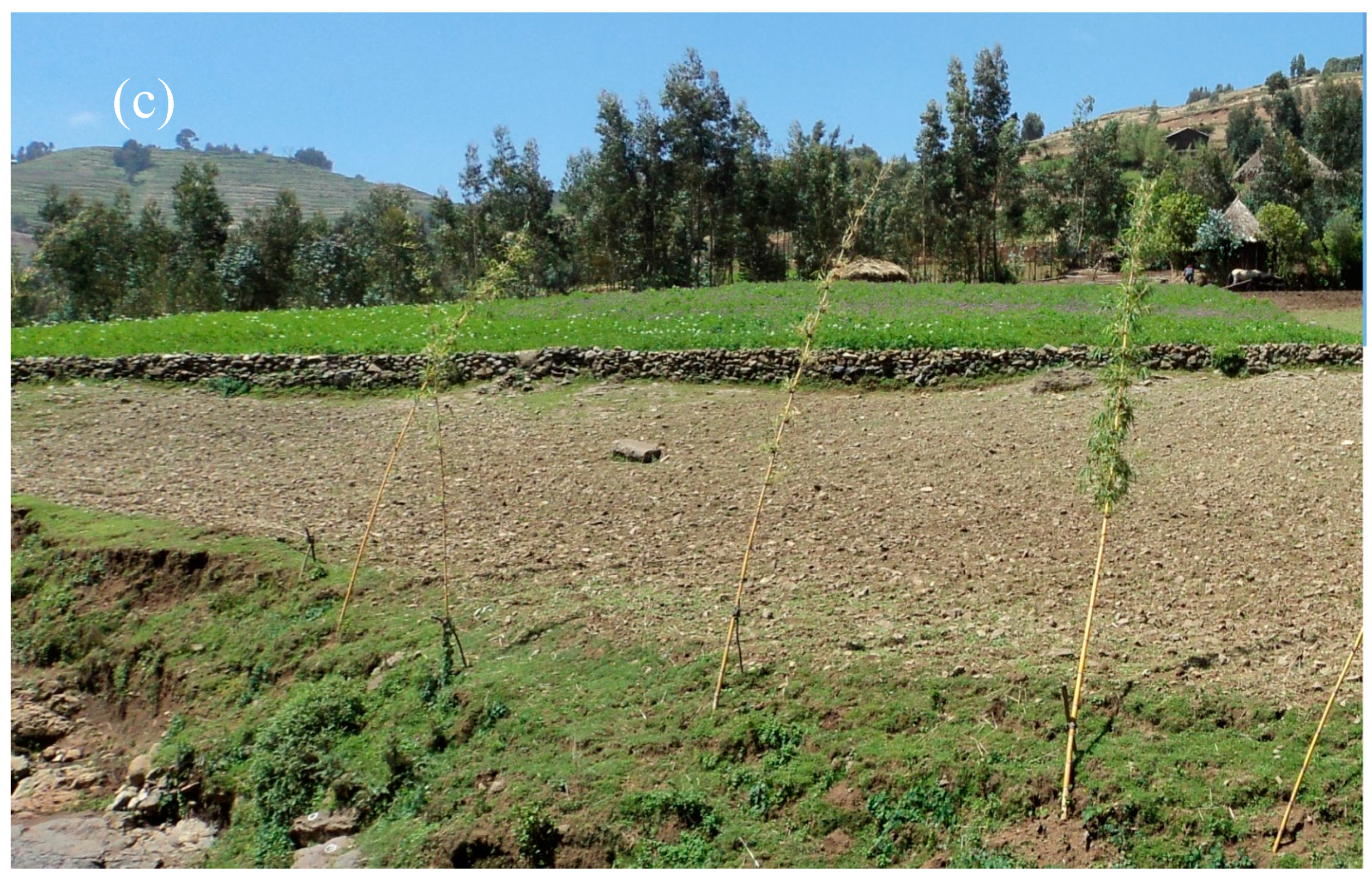
The community watershed development program proposed the construction of site specific conservation techniques that included 50–60 cm deep infiltration furrows with soil bunds downhill (some of which were faced with stones) and stone buds with stones gathered from the surrounding area, waterways, cut off drains, gully rehabilitation with gabions and check dams, hillside terracing, micro basins, and planting of fodder and woodlots on communal lands (Figure 2a–c, Table 2). In the two years, 23% of the Guale watershed and 18% of the Tikur-Wuha watershed was treated with conservation practices (Table 2).
The infiltration furrows with bunds were built along the contour across the sloping lands to decrease runoff by reducing or stopping the overland flow and increasing the infiltration of rainwater into the soil in the furrows. Note that due to erosion and filling up of the furrows, most of these practices are only effective for approximately five years [30]. Enclosures are areas closed for free grazing and cultivation, commonly found on degraded marginal lands not suitable for crop cultivation and in valley bottoms where gullies are being formed. Natural vegetation is regenerating, erosion is reduced, and the soils are stabilized on the enclosures. Check dams reduce the effective slope of the channel, thereby reducing the velocity of flowing water, allowing sediment to settle and reducing channel erosion. Check dams require maintenance to be effective [32,33].

2.2. Data Collection

Precipitation, discharge, and sediment concentration were measured during the 2010–2012 period.
Precipitation: Beginning in 2010, the daily precipitation was measured with manual rain gauges located near the outlet of each watershed by the Tana Beles Project. The daily precipitation was measured from the beginning of 2010 to the end of 2012 using manual rain gauges at the outlet of the two watersheds. Data collectors measured the rainfall twice a day and several times during a rain storm. The data collectors recorded the depth of the water inside the graduated cylinder in mm. For both watersheds, the depth and duration of each rainfall event were recorded.
Discharge: River gauges were established at the outlet of both watersheds in 2010. The daily stream flow depth was recorded twice a day during base flow and every 30 min during storm events. The measurements were taken manually. A stage-discharge rating curve was developed. The flow depth was measured with a staff gauge. Manual measurements of flow depth and velocity started when the water in the stream became turbid. Both water depth and surface water velocity (V, m s−1) at the outlet of the two watersheds were recorded at 30-min intervals until the water became less turbid. The surface velocity was determined with a float that was released at 5 to 10 m upstream from the outlet of the watersheds, which was then divided by the time taken to reach the staff gauges. The velocity distribution was not uniform in the stream [34]. The mean velocity in the stream was obtained by multiplying the surface velocity by two-thirds for the fast-flowing streams in mountainous areas [34]. The discharge was determined by multiplying the mean velocity by the cross-sectional area of the stream [35].
Sediment concentration: This was measured manually twice a day during the base flow and at 30-min intervals during a storm event. Samples were collected in 1 L plastic bottles. At the end of each month, the bottles were transported to the lab. Sediment concentrations were determined by adding 5–25 mL of Al2SO4 coagulant to the 1 L sample in the graduated beakers and left to settle overnight. Samples were decanted and placed in an oven for 24 h to determine the oven dry weight.

2.3. Data Analysis

Monthly and annual runoff coefficients were calculated as the ratio of runoff depth and precipitation over the respective periods. Sediment load was calculated as the sum of the products of the sediment concentration and discharge over the period between the mid-points of subsequent sampling events.
A flow duration curve was constructed from the daily stream flow of each watershed by sorting the daily discharge for the 2010–2012 period from the largest to the smallest values, and assigning each discharge value a rank (r), starting with 1 for largest values and N for the lowest values. Then, the exceeding probability was calculated using the Weibull plotting routine [36].
P = ( r N + 1 ) × 100
where P is the percentage of time that the flow is equaled or exceeded, N is the total number of daily flow in the 2010–2012 period, and r is the rank assigned to each daily streamflow value.

3. Results

3.1. Precipitation

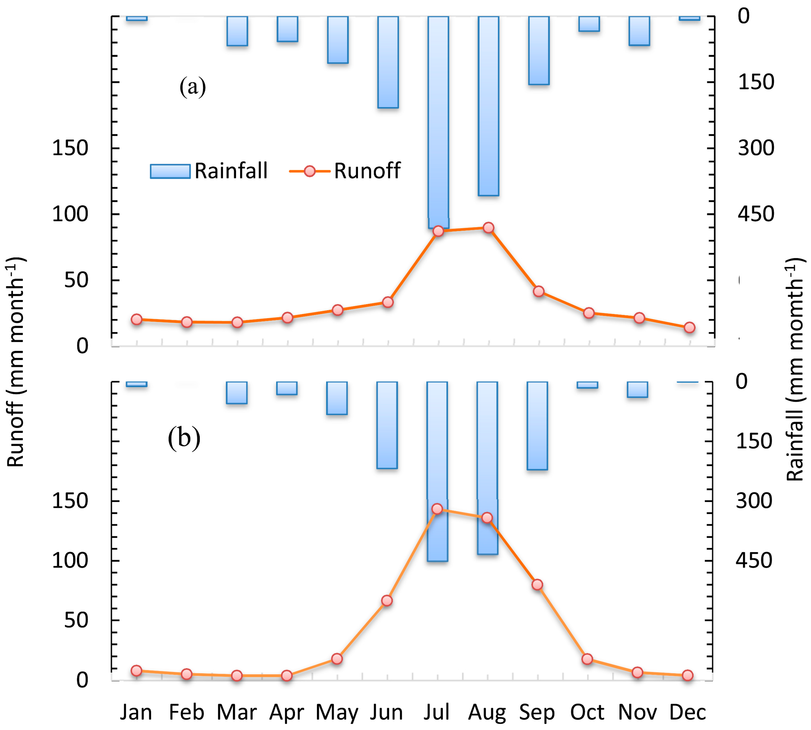
The precipitation for the two watersheds was similar (Figure 3). In the Tikur-Wuha watershed, the average annual precipitation over the three-year period was 1602 mm y−1 and ranged from 1676 mm y−1 in 2011 to 1552 mm y−1 in 2012 (Table S1). In the Guale watershed, the mean annual precipitation in 2010–2012 was 1561 mm y−1 and ranged from 1682 mm y−1 in 2011 to 1470 mm y−1 in 2012 (Figure 3, Table S2). Eighty-five percent of the annual precipitation was concentrated in the period of May–September (Tables S1 and S2).
As shown by the average monthly rainfall distribution in both watersheds (Figure 3), the months from October to December constitute the dry season; the wet season extends from June to September, with a heavy rainfall concentration in July and August. Rain also occurs in January, March, April, and May, with a peak in March, but it is a very small amount. The driest season is February. During the dry season between October and December, the stream flow of the watershed is only base flow [37]. In the Tikur-Wuha watershed, base flow from October to December increased after conservation practices were installed.

3.2. Discharge

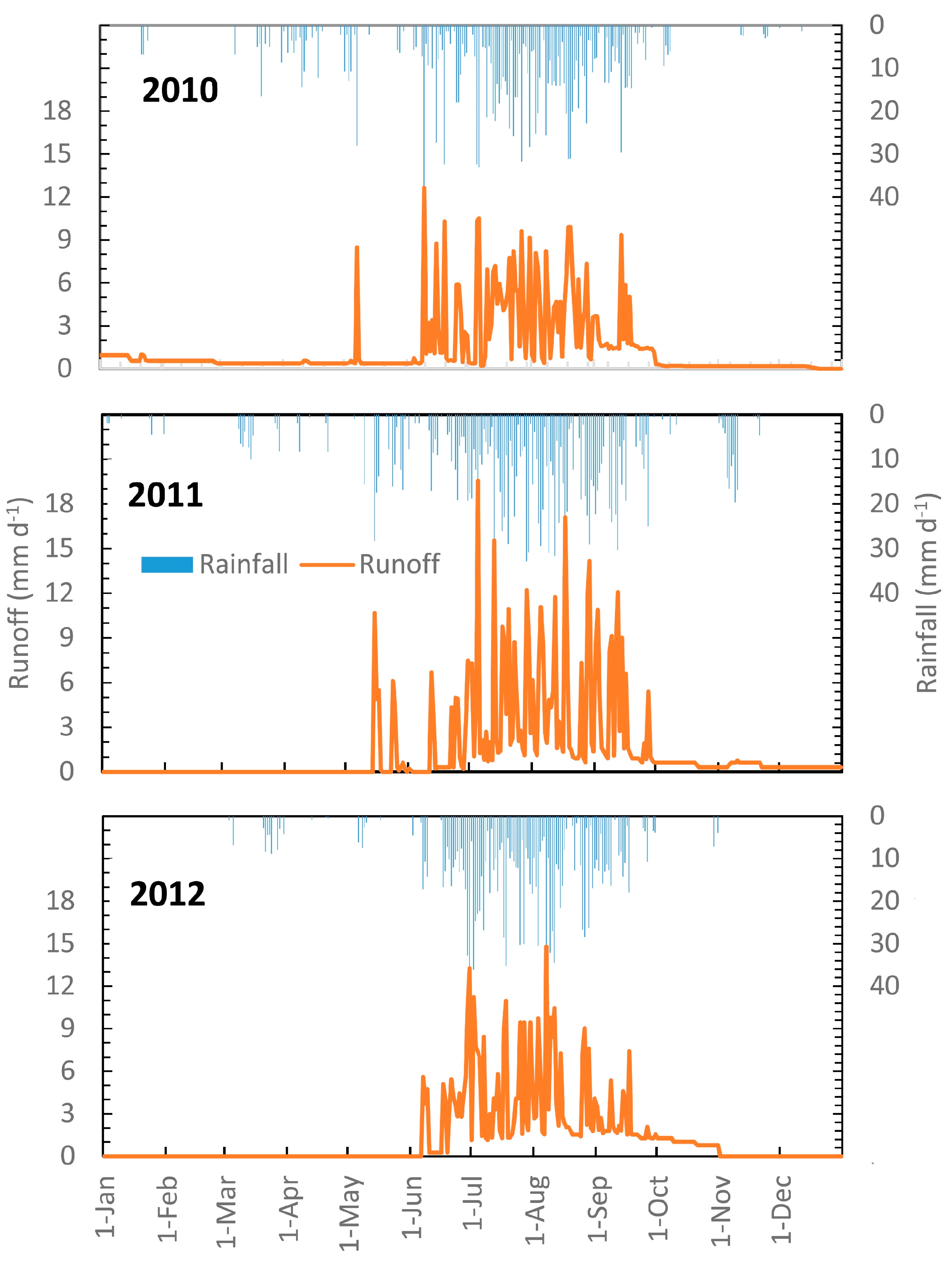
The daily (Figure 4 and Figure 5) and monthly discharge (Figure 3) follow the typical pattern in the northern Ethiopian highlands with the greatest discharge in the two wettest months of July and August. The mean annual runoff depth for 2010–2012 in Tikur-Wuha was 419 mm y−1 and 493 mm y−1 in the Guale watershed. Thus, the steep Guale watershed with shallow soils had 76 mm y−1 more discharge with an average rainfall that was 50 mm y−1 less than the Tikur-Wuha watershed with deep soils and gentle slopes (Tables S1 and S2). The greater discharge in the shallower watershed agrees with saturation excess runoff theory, where the portion of saturated soil increases for a given storm with decreasing soil depth. This results in more direct runoff generated, shortening the residence time in the watershed and consequently leading to less evapotranspiration from the rainwater [38,39].
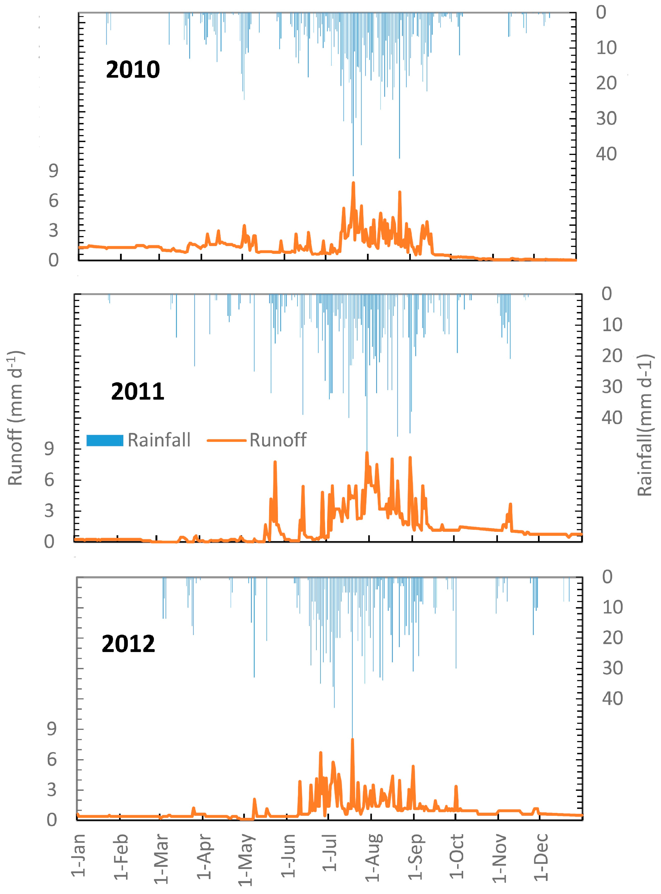
As expected, during the rain monsoon phase from May to September, a similar difference in discharge was found (Table 3). The average discharge of the Guale watershed compared to the Tikur-Wuha watershed was 165 mm y−1 greater with 88 mm more precipitation. In addition, runoff in the Guale watershed started in the beginning of the rain phase, while in the Tikur-Wuha, the runoff responses was towards the middle and end of the rainy periods (Figure 3, Figure 4 and Figure 5) since it took longer to bring the soil to field capacity and flow to start. Moreover, the deep soil in the Tikur-Wuha watershed had more water stored at the end of the rain phase than the Guale watershed. The stored water was released after the rains ended and hence the Tikur-Wuha had more baseflow from October to December than the Guale watershed (Figure 4 and Figure 5). Finally, the flow stopped earlier in the Guale watershed because the water flowed faster down the hill due to the steeper slope. Consequently, the retention time was shorter (Figure 4 and Figure 5). Despite the shorter retention time should be related to more baseflow initially in the Guale watershed, it was still less than the Tikur-Wuha watershed because of the smaller amount of water stored in the Guale wathershed.
The discharge during the rain phase in the Tikur-Wuha watershed increased in 2011 despite the installation of the conservation practices because the increased rainfall had a greater effect (Table 3 and Table S1). The discharge decreased slightly in 2012 compared to 2010 (Table 3 and Table S1). In the Guale watershed, the runoff volume during the rainy phase increased in 2011 and 2012 due to the greater rainfall amounts after soil and water conservation implementation (Table 3 and Table S2). Despite a greater portion of the Guale watershed being treated with conservation measures (Table 2), the baseflow hardly changed due to these practices (Figure 5).

3.2.1. Runoff Coefficients

To compare the discharge between the two watersheds independent of the amount of rainfall, runoff coefficients (e.g., the ratio of runoff to rainfall) were calculated for the rain season (May–September). We found that the annual runoff coefficients of the Tikur-Wuha watershed ranged from 23% to 18% and the Guale watershed ranged from 31% to 33% (Table 3). This is due to the difference in soil depth in the two watersheds as described further in the discussion section. The Tikur-Wuha watershed runoff coefficient increased by 10% in 2011 due to an increased rainfall amount; as compared with 2010, it decreased by 14% in 2012 (Table 3). In the Guale watershed, the runoff coefficient increased in 2011 and then decreased in 2012, but to a much smaller degree (Table 3). Thus, conservation measures increased infiltration when the rainfall amounts were similar (2010 vs. 2012) in the Tikur-Wuha watershed. The implementation of soil and water conservation practices had a relatively small effect compared with the increase in precipitation.

3.2.2. Flow Duration Curve

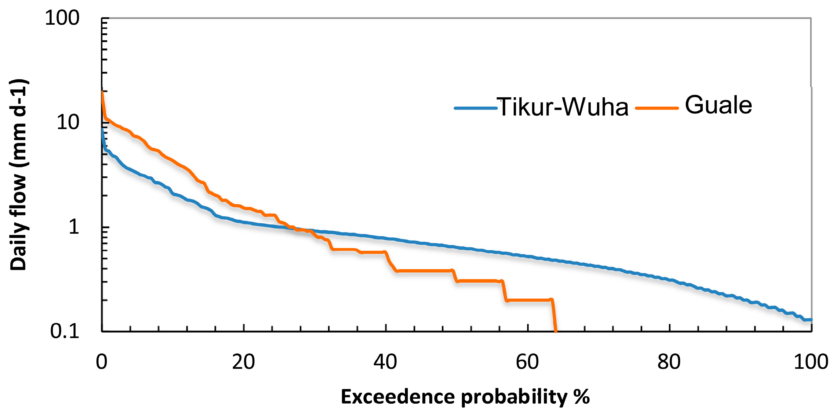
The annual flow duration curves for the 2010–2012 period clearly indicated the different runoff patterns between the two watersheds (Figure 6). The shape of the flow duration curve is determined by the hydrological and geological characteristics of the drainage area and can be used to compare the watersheds with each other [40].
The Tikur-Wuha watershed, with deep soils and gentle channel slopes, exhibited flow during the entire period, while the low flows in the Guale watershed ceased. High flows in the Guale watershed were greater than in the Tikur-Wuha watershed, while the low flows were less. This stark contrast in discharge was related to soil depth and slope. The greater the slope, the greater the velocity of the subsurface moving water and the faster the flow stopped. Additionally, the shallow soil depth meant that less water could be stored in the watershed resulting in greater saturated areas and consequently more surface runoff, as discussed in more detail in the Discussion.

3.3. Sediment

3.3.1. Sediment Concentrations

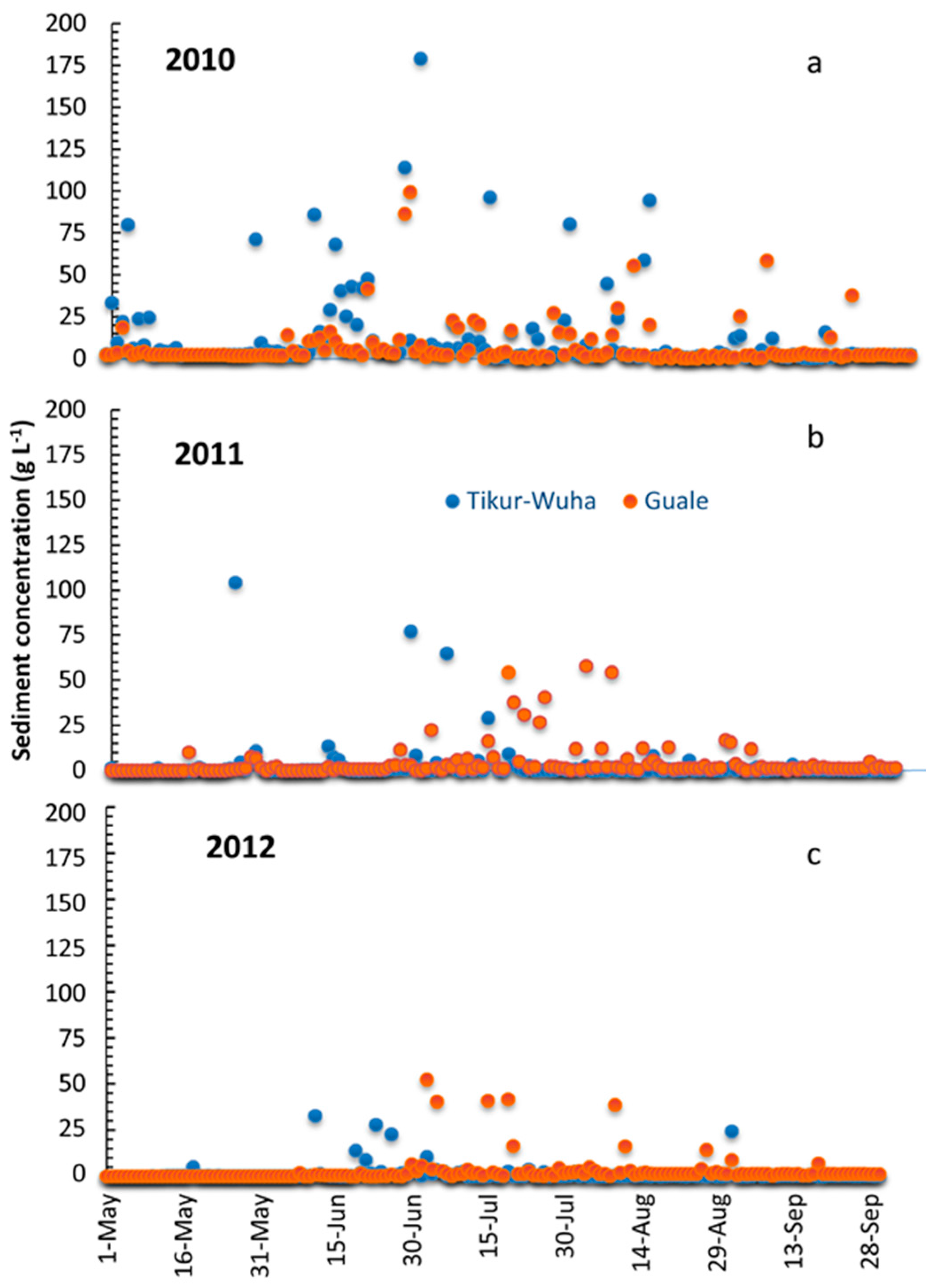
In both watersheds, sediment concentrations were generally greater at the beginning of the rainy phase (May and June) and decreased toward the end of the wet season (August and September) (Figure 6). This was especially distinct before the implementation of the soil and water conservation practices (Figure 7a) and in 2011 during a large storm in the Tikur-Wuha watershed (Figure 7b).

3.3.2. Sediment Yield

After soil and water conservation implementation, there was a reduction of sediment load in both watersheds. However, the magnitude of reduction was quite different between the two watersheds. Before the implementation of soil and water conservation, the sediment load of the Tikur-Wuha watershed was higher than the Guale watershed. However, after implementation, the result reversed (Table 4). As expected from the sediment concentration and discharge results, the greatest reduction in sediment yield during the implementation of the soil and water conservation practice was found in the Tikur-Wuha watershed, where sediment yield decreased by 58% in 2011 and by 84% in 2012. In the Guale watershed, the sediment yield decreased by 6% in 2011 and 45% in 2012 (Table 4).

4. Discussion

We will first discuss the impact of soil and water conservation on hydrology and then explain the differences in hydrological responses in the two watersheds.

4.1. Overall Impact of Soil and Water Conservation on Hydrological Response of Watersheds

The implementation of conservation measures (infiltration furrows, waterways, cutoff drains, hillside terracing, and micro basins), together with the treatment of gullies and enclosures (Figure 2a–c, Table 2) in the two watersheds, had the greatest positive impact on reducing sediment transport from the watersheds. Although the conservation measures might have reduced the discharge during the rain phase slightly, the amount of rainfall was clearly more important in determining the total amount of discharge (Table 3, Tables S1 and S2). Other studies have shown that upland conservation practices decreased direct runoff in Ethiopia [18,22,41] and elsewhere in the world [42,43]. The effect on discharge of the soil and conservation practices at the outlet in the Guale watershed was minimal, while in the Tikur-Wuha watershed, which could store the additional amount of infiltrated water, the direct runoff was decreased for comparable amounts of annual rainfall (Table 3, Tables S1 and S2).
After the rain stopped in September, the baseflow in the Tikur-Wuha watershed (Figure 3) was increased due to both the implementation of the conservation practices and because of greater amounts of rains (Figure 4 and Figure S1). In 2011, when soil and water conservation practices were implemented, and the greatest amount of rain fell (Table 3), the baseflow was the greatest (Figure 4b). In 2010 and 2012, when the precipitation was comparable during the rain phase (Table 3), the baseflow in the dry phase after September was greater in 2012 after the implementation of practices than for 2010 (Figure 4a,c). In the Guale watershed, with the shallow soil and steep gradient, the effect of the conservation measures and amount of rainfall on the baseflow, if any was exhibited, was much less significant (Figure 5 and Figure S1).
Unlike other watersheds in the highlands, the decrease in peak sediment concentration (Figure 7) was not very distinct with the progression of the rain phase [22,23]. In most watersheds, sediment concentrations are elevated in the beginning of the rain phase after the soils are plowed and rills form [22,23,28,44,45,46,47]. Once the rills have formed, sediment concentrations decrease. When gullies are present downstream, any decrease in sediment is negated by unconsolidated sediments of the slipping banks that can easily be picked up by the flowing water in the gullies [48,49]. Under these circumstances, the peak sediment concentrations remain elevated throughout the rain phase, as seen in the Tikur-Wuha and the Guale watersheds, especially in 2010 before gully rehabilitation practices were in place (Figure 7a).
Sediment concentrations and loads decreased greatly in both watersheds after the implementation of conservation measures (Figure 7b,c). In the Debre Mawi watershed [22,28,48,49], in cases where gullies were not treated, we found that the sediment concentration at the outlet did not decrease after the installation of upland conservation practices because the unconsolidated soil in the gullies added the sediment back into the water that was taken out by the upland practices. Here, gullies were treated (Table 2) and sediment concentration decreased because gullies are the major sources of sediment [50,51,52].

4.2. Effect of Topography and Soil Depth on Effectiveness of Soil and Water Conservation Works

4.2.1. Discharge

The runoff coefficient in the Tikur-Wuha watershed was much smaller than in the Guale watershed (Table 4). To discuss the differences in discharge and runoff coefficients between the two watersheds, we note that prior experimental studies have found that the main runoff generation mechanism in the (sub) humid Ethiopian highlands is saturation excess runoff [15,20,22,24,45,46,47,48]. Saturated excess overland flow occurs at locations either where the soils become saturated above an impeding layer or where the regional groundwater reaches the surface. In addition, since the soil types of the watersheds are similar (both Chromic-Luvisols) and consequently have the same infiltration capacity, the observed differences in direct runoff (Table 3) cannot be explained by the infiltration excess runoff mechanism. Based on this, we can conclude that the runoff coefficients and discharge are less for the deeper soils in the Tikur-Wuha watershed than for the Guale watershed, where soils are shallower (Figure 1e,f). The deeper soils could store more of the rain water before the soil was saturated. Consequently, in the Guale watershed, the saturated areas formed earlier after the beginning of the rain phase and resulted in both an earlier start of and more direct runoff than in the Tikur-Wuha watershed (Figure 4 and Figure 5, Table 3).
The flow duration curve in Figure 6 confirms the above findings. The curve, with a steep slope for the Guale watershed, indicates the highly variable stream flow with flows that are largely from direct runoff; whereas a curve with a flat slope for the Tikur-Wuha watershed shows that baseflow is also substantial (Figure 6). The flat slope at the lower end in the Tikur-Wuha watershed indicates a large amount of water storage [53]. However, a steep slope at the lower end in the Guale watershed indicates a negligible amount [53]. This confirms, again, that watershed storage affected by both slope and depth of soil plays an important role in the hydrological characteristics of these watersheds.
Finally, our findings agree with [38,54] in that soil depth is highly significant in controlling the portion of flow, i.e., direct runoff and base flow. As the depth of soil increases, interflow and base flow increase. However, as the soil depth decreases, direct runoff increases in regions with saturation excess overland flow, such as in the Ethiopian highlands. For the same reason, the baseflow was not affected in the Guale watershed by the conservation practices because the watershed was at its maximum storage throughout the rain phase. Any additional infiltration by conservation practices could not be stored. In contrast, the storage in the Tikur-Wuha watershed was not restricted and additional infiltration water could be held and released during the dry phase, thereby increasing baseflow.

4.2.2. Sediment Loss

The peak sediment concentrations in the Tikur-Wuha watershed were greater than in the Guale watershed before soil and water conservation implementation (Figure 7a), while this was nearly reversed after implementation (Figure 7b,c). Despite its relatively flatter slope near the outlet and expected deposition of sediment, the sediment concentrations in the Tikur-Wuha watershed were greater before implementation in 2010 because peak discharge volumes were greater due to its larger size (Table 1).
The sediment load reduction of 71% in 2012 was greater in the Tikur-Wuha watershed with a smaller portion of the watershed being treated than the 23% of the Guale watershed (Table 2 and Table 4). Although there was a relatively small reduction in runoff, the greatest effect was the reduction in sediment concentration. The sediment concentrations decreased in 2011 and 2012 in both watersheds because of the gully rehabilitation and enclosures, but were likely more effective in the moderately sloping Tikur-Wuha watershed (Figure 7).
The lesson learned from the comparison of these two watersheds, as well as from other watersheds such as the Debre-Mawi watershed, is that gully treatment should be incorporated into conservation programs in the Ethiopian highlands to increase its effectiveness. The results also show that conservation programs are generally more effective in watersheds with deeper soil depths and with gentle slopes than in watersheds with shallow soils (with limited storage) and steep slopes.

5. Conclusions

The implementation of soil and water conservation practices as part of the Tana Beles Integrated Watershed Management Project in the watersheds has reduced sediment concentration and sediment load, and marginally reduced runoff volumes, thereby contributing to the reduction in sediment transported in the upper Blue Nile basin. Soil depth and slope position of the watershed influenced the effectiveness of the integrated watershed management practices. The Tikur-Wuha watershed, which has deep soil and a gentle channel slope, has shown a greater reduction in sediment load and runoff than the Guale watershed, which has shallow soil and a steeper slope. Further studies are needed to confirm the findings.

Supplementary Materials

The following are available online at www.mdpi.com/2073-445X/6/4/78/s1, Table S1: Monthly rainfall and runoff depth (mm/month) of the Tikur-Wuha watershed (2010–2012), Table S2: Monthly rainfall and runoff depth (mm/month) of the Guale watershed (2010–2012).

Acknowledgments

Data for this research work was obtained from the Tana-Beles Integrated Water Resources Development Project. We would like to thank the project team for their time and unwavering support for data compilation, the Borlaug LEAP, and Partnerships for Enhanced Engagement in Research (PEER) of the National Academies of Sciences, Engineering, Medicine of the USA for their financial support, and the first author for the fellowship and research support. We would like to thank Peggy Stevens for her help in improving the English.

Author Contributions

A.T.A., S.A.T., W.M., M.A.B. and T.S.S. conceived and designed the experiments; A.T.A. performed the experiments; A.T.A. and D.C.D. analyzed the data; W.M. contributed reagents/materials/analysis tools; A.T.A. and T.S.S. wrote the paper with aid of S.A.T., D.C.D., W.M. and M.A.B.

Conflicts of Interest

The authors declare no conflict of interest. The sponsors had no role in the design of the study, in the collection, analyses, or interpretation of data in the writing of the manuscript, nor in the decision to publish the results.

References

  1. Lieskovský, J.; Kenderessy, P. Modeling the effect of vegetation cover and different tillage practices on soil erosion in vineyards: A case study en Vráble (Slovakia) using WATER/SEDEM. Land Degrad. Dev. 2014, 25, 288–296. [Google Scholar] [CrossRef]
  2. Kim, J.; Choi, J.; Choi, C.; Park, S. Impacts of changes in climate and land use/land cover under IPCC RCP scenarios on stream flow in the Hoeya River Basin, Korea. Sci. Total Environ. 2013, 452, 181–195. [Google Scholar] [CrossRef] [PubMed]
  3. Setegn, S.G.; Srinivasan, R.; Dargahi, B.; Melesse, A.M. Spatial delineation of soil erosion vulnerability in the Lake Tana Basin, Ethiopia. Hydrol. Process. 2009, 23, 3738–3750. [Google Scholar] [CrossRef]
  4. Kassie, M.; Pender, J.; Yesuf, M.; Kohlin, G.; Bluffstone, R.; Mulugeta, E. Estimating returns to soil conservation adoption in the northern Ethiopian highlands. Agric. Econ. 2008, 38, 213–232. [Google Scholar] [CrossRef]
  5. Pimentel, D.; Burgess, M. Soil erosion threatens food production. Agriculture 2013, 3, 443–463. [Google Scholar] [CrossRef]
  6. Huang, M.; Gallichand, J.; Zhang, P. Runoff and sediment responses to conservation practices: Loess Plateau of China. J. Am. Water Resour. Assoc. 2003, 39, 1197–1207. [Google Scholar] [CrossRef]
  7. García-Ruiz, J.M.; Nadal-Romero, E.; Lana-Renault, N.; Beguería, S. Erosion in Mediterranean landscapes: Changes and future challenges. Geomorphology 2013, 198, 20–36. [Google Scholar] [CrossRef] [Green Version]
  8. Kosmas, C.; Danalatos, N.; Cammeraat, L.H.; Chabart, M.; Diamantopoulos, J.; Farand, R.; Gutierrez, L.; Jacob, A.; Marques, H.; Martinez-Fernandez, J.; et al. The effect of land use on runoff and soil erosion rates under Mediterranean conditions. Catena 1997, 29, 45–59. [Google Scholar] [CrossRef]
  9. United States Department of Agriculture-Natural Resources Conservation Services (USDA-NRCS). Summary Report 2010 National Resources Inventory; Iowa State University Statistical Laboratory: Ames, IA, USA, 2013; p. 163.
  10. Constable, M.; Belshaw, D. The Ethiopian highlands reclamation study: Major findings and recommendations. In Towards a Food and Nutrition Strategy for Ethiopia: Proceedings of the National Workshop on Food Strategies for Ethiopia; ONCCP (Office of the National Committee for Central Planning): Addis Ababa, Ethiopia, 1986; pp. 8–12. [Google Scholar]
  11. Hurni, H.; Tato, K. (Eds.) Erosion, Conservation, and Small-Scale Farming; Geographical Bernensia: Bern, Switzerland, 1992. [Google Scholar]
  12. Tamene, L.; Vlek, P.L. Soil erosion studies in northern Ethiopia. In Land Use Soil Resources; Springer: Dordrecht, The Netherlands, 2008; pp. 73–100. [Google Scholar]
  13. Kidane, D.; Alemu, B. The effect of upstream land use practices on soil erosion and sedimentation in the Upper Blue Nile Basin, Ethiopia. Res. J. Agric. Environ. Manag. 2015, 4, 55–68. [Google Scholar]
  14. Bewket, W.; Teferi, E. Assessment of soil erosion hazard and prioritization for treatment at the watershed level: Case study in the Chemoga watershed, Blue Nile basin, Ethiopia. Land Degrad. Dev. 2009, 20, 609–622. [Google Scholar] [CrossRef]
  15. Haregeweyn, N.; Tsunekawa, A.; Poesen, J.; Tsubo, M.; Meshesha, D.T.; Fenta, A.A.; Nyssen, J.; Adgo, E. Comprehensive assessment of soil erosion risk for better land use planning in river basins: Case study of the Upper Blue Nile River. Sci. Total Environ. 2017, 574, 95–108. [Google Scholar] [CrossRef] [PubMed]
  16. Zimale, F.A.; Moges, M.A.; Alemu, M.L.; Ayana, E.K.; Ayana, E.K.; Demissie, S.S.; Tilahun, S.A.; Steenhuis, T.S. Budgeting suspended sediment fluxes in tropical monsoonal watersheds with limited data: The Lake Tana basin. J. Hydrol. Hydromech. 2017, in press. [Google Scholar]
  17. Assefa, T.T.; Jha, M.K.; Tilahun, S.A.; Yetbarek, E.; Adem, A.A.; Wale, A. Identification of erosion hotspot area using GIS and MCE technique for Koga watershed in the upper blue Nile Basin, Ethiopia. Am. J. Environ. Sci. 2015, 11, 245. [Google Scholar] [CrossRef]
  18. Devi, R.; Tesfahune, E.; Legesse, W.; Deboch, B.; Beyene, A. Assessment of siltation and nutrient enrichment of Gilgel Gibe dam, Southwest Ethiopia. Bioresour. Technol. 2008, 99, 975–979. [Google Scholar] [CrossRef] [PubMed]
  19. Nyssen, J.; Poesen, J.; Moeyersons, J.; Haile, M.; Deckers, J. Dynamics of soil erosion rates and controlling factors in the Northern Ethiopian Highlands–towards a sediment budget. Earth Surf. Process. Landf. 2008, 33, 695–711. [Google Scholar] [CrossRef] [Green Version]
  20. Tebebu, T.Y.; Bayabil, H.K.; Stoof, C.R.; Giri, S.K.; Gessess, A.A.; Tilahun, S.A.; Steenhuis, T.S. Characterization of degraded soils in the humid Ethiopian highlands. Land Degrad. Dev. 2016. [Google Scholar] [CrossRef]
  21. Tebebu, T.Y.; Steenhuis, T.S.; Dagnew, D.C.; Guzman, C.D.; Bayabil, H.K.; Zegeye, A.D.; Collick, A.S.; Langan, S.; McAllister, C.; Langendoen, E.J.; et al. Improving efficacy of landscape interventions in the (sub) humid Ethiopian highlands by improved understanding of runoff processes. Front. Earth Sci. 2015, 3, 49. [Google Scholar] [CrossRef]
  22. Osman, M.; Sauerborn, P. Soil and water conservation in Ethiopia. J. Soils Sediments 2001, 1, 117–123. [Google Scholar] [CrossRef]
  23. Dagnew, D.C.; Guzman, C.D.; Zegeye, A.D.; Tebebu, T.Y.; Getaneh, M.; Abate, S.; Zimale, F.A.; Ayana, E.K.; Tilahun, S.A.; Steenhuis, T.S. The impact of conservation practices on runoff and soil loss in the sub-humid Ethiopian Highlands: The Debre Mawi watershed. J. Hydrol. Hydromech. 2015, 63, 210–219. [Google Scholar] [CrossRef]
  24. Ministry of Finance and Economic Development (MOFED). Growth and Transformation Plan of Ethiopia (GTP), 2010/2011–2014/15 of the Federal Democratic Republic of Ethiopia (FDRE); MOFED: Addis Ababa, Ethiopia, 2010.
  25. Easton, Z.M.; Fuka, D.R.; White, E.D.; Collick, A.S.; Biruk Ashagre, B.; McCartney, M.; Awulachew, S.B.; Ahmed, A.A.; Steenhuis, T.S. A multi-basin SWAT model analysis of runoff and sedimentation in the Blue Nile, Ethiopia, Hydrol. Earth Syst. Sci. 2010, 14, 1827–1841. [Google Scholar] [CrossRef]
  26. Kebede, S.; Travi, Y.; Alemayehu, T.; Marc, V. Water balance of Lake Tana and its sensitivity to fluctuations in rainfall, Blue Nile basin, Ethiopia. J. Hydrol. 2006, 316, 233–247. [Google Scholar] [CrossRef]
  27. Dessie, M.; Verhoest, N.E.C.; Pauwels, V.R.N.; Admasu, T.; Poesen, J.; Adgo, E.; Deckers, J.; Nyssen, J. Analyzing runoff processes through conceptual hydrological modeling in the Upper Blue Nile basin, Ethiopia. Hydrol. Earth Syst. Sci. Dis. 2014, 11, 5287–5325. [Google Scholar] [CrossRef]
  28. Dagnew, D.C.; Guzman, C.D.; Zegeye, A.D.; Akal, A.T.; Moges, M.A.; Tebebu, T.Y.; Mekuria, W.; Ayana, E.K.; Tilahun, S.A.; Steenhuis, T.S. Sediment loss patterns in the sub-humid Ethiopian Highlands. Land Degrad. Dev. 2017, 28, 1795–1805. [Google Scholar] [CrossRef]
  29. Dagnew, D.C.; Guzman, C.D.; Akale, A.T.; Tebebu, T.Y.; Zegeye, A.D.; Mekuria, W.; Tilahun, S.A.; Steenhuis, T.S. Effects of land use on catchment runoff and soil loss in the sub-humid Ethiopian highlands. Ecohydrol. Hydrobiol. 2017. [Google Scholar] [CrossRef]
  30. Guzman, C.D.; Zimale, F.A.; Tebebu, T.Y.; Bayabil, H.K.; Tilahun, S.A.; Yitaferu, B.; Rientjes, T.H.M.; Steenhuis, T.S. Modeling discharge and sediment concentrations after landscape interventions in a humid monsoon climate: The Anjeni watershed in the highlands of Ethiopia. Hydrol. Process. 2017, 31, 1239–1257. [Google Scholar] [CrossRef]
  31. Amhara Design and Supervision Works Enterprise (ADSWE). Soil Map of Amhara Region, Land Use and Administration Work Process; Amhara Design and Supervision Works Enterprise (ADSWE): Bahir Dar, Ethiopia, 2012. [Google Scholar]
  32. Ayele, G.K.; Gessess, A.A.; Addisie, M.B.; Tilahun, S.A.; Tebebu, T.Y.; Tenessa, D.B.; Langendoen, E.J.; Nicholson, C.F.; Steenhuis, T.S. A biophysical and economic assessment of a community-based rehabilitated gully in the Ethiopian Highlands. Land Degrad. Dev. 2016, 270–280. [Google Scholar] [CrossRef]
  33. Addisie, M.B.; Ayele, G.K.; Gessess, A.A.; Tilahun, S.A.; Zegeye, A.D.; Moges, M.M.; Schmitter, P.; Langendoen, E.J.; Steenhuis, T.S. Gully head retreat in the sub-humid Ethiopian Highlands: The Ene-Chilala catchment. Land Degrad. Dev. 2017, 1579–1588. [Google Scholar] [CrossRef]
  34. Chanson, H. Hydraulics of Open Channel Flow; Butterworth-Heinemann: Oxford, UK, 2004. [Google Scholar]
  35. Tilahun, S.A. Observations and Modeling of Erosion from Spatially and Temporally Distributed Sources in the (Semi) Humid Ethiopian Highlands. Ph.D. Dissertation, Cornell University, Ithaca, NY, USA, 2012. [Google Scholar]
  36. Sugiyama, H.; Vudhivanich, V.; Whitaker, A.C.; Lorsirirat, K. stochastic flow duration curves for evaluation of flow regimes in rivers. J. Am. Water Resour. Assoc. 2003, 39, 47–58. [Google Scholar] [CrossRef]
  37. Bewket, W.; Sterk, G. Dynamics in land cover and its effect on stream flow in the Chemoga watershed, Blue Nile basin, Ethiopia. Hydrol. Process. 2005, 19, 445–458. [Google Scholar] [CrossRef]
  38. Steenhuis, T.S.; Hrncir, M.; Poteau, D.A.; Luna, E.J.R.; Tilahun, S.A.; Caballero, L.A.; Guzman, C.D.; Stoof, C.R.; Sanda, M.; Yitaferu, B.; et al. Saturated excess runoff pedo transfer function for vegetated watersheds. Vadose Zone J. 2013, 4. [Google Scholar] [CrossRef]
  39. Ferreira, C.S.S.; Walsh, R.P.D.; Steenhuis, T.S.; Ferreira, A.J.D. Effect of peri-urban development and lithology on streamflow in a Mediterranean catchment. Land Degrad. Dev. 2017, in press. [Google Scholar] [CrossRef]
  40. Searcy, J.K. Flow-Duration Curves; US Government Printing Office: Washington, DC, USA, 1959.
  41. Nyssen, J.; Clymans, W.; Poesen, J.; Vandecasteele, I.; De Baets, S.; Haregeweyn, N.; Naudts, J.; Hadera, A.; Moeyersons, J.; Haile, M.; et al. How soil conservation affects the catchment sediment budget–a comprehensive study in the north Ethiopian highlands. Earth Surf. Process. Landf. 2009, 34, 1216–1233. [Google Scholar] [CrossRef]
  42. Valentin, C.; Agus, F.; Alamban, R.; Boosaner, A.; Bricquet, J.P.; Chaplot, V.; De Guzman, T.; De Rouw, A.; Janeau, J.L.; Orange, D.; et al. Runoff and sediment losses from 27 upland catchments in Southeast Asia: Impact of rapid land use changes and conservation practices. Agric. Ecosyst. Environ. 2008, 128, 225–238. [Google Scholar] [CrossRef]
  43. Valentin, C.; Boonsaner, A.; Janeau, J.L.; Jouquet, P.; Henry Des Tureaux, T.; Huon, S.; Latsachack, K.; Le Troquer, Y.; Maeght, J.L.; Orange, D.; et al. Lessons from long-term monitoring of soil erosion in three Southeast Asian agricultural catchments undergoing rapid land-use changes. In Hydrology in A Changing World: Environmental and Human Dimensions; Daniell, T.M., Van Lanen, H.A.J., Demuth, S., Laaha, G., Servat, E., Mahé, G., Boyer, J.-F., Paturel, J.-E., Dezetter, A., Ruelland, D., Eds.; IAHS Publication: Wallingford, UK, 2014; pp. 303–308. [Google Scholar]
  44. Guzman, C.D.; Tilahun, S.A.; Zegeye, A.D.; Steenhuis, T.S. Suspended sediment concentration-discharge relationships in the sub-humid Ethiopian highlands. Hydrol. Earth Syst. Sci. 2013, 17, 1067–1077. [Google Scholar] [CrossRef]
  45. Vanmaercke, M.; Zenebe, A.; Poesen, J.; Nyssen, J.; Vertstraeten, G.; Deckers, J. Sediment dynamics and the role of flash floods in sediment export from medium-sized catchments: A case study from the semi-arid tropical highlands in Northern Ethiopia. J. Soil Sediment 2010, 10, 611–627. [Google Scholar] [CrossRef] [Green Version]
  46. Awulachew, S.B.; McCartney, M.; Steenhuis, T.S.; Ahmed, A.A. A Review of Hydrology, Sediment and Water Resource Use in the Blue Nile Basin; IWMI Working Paper; International Water Management Institute: Colombo, Sri Lanka, 2008; Volume 131, p. 87. [Google Scholar]
  47. Bayabil, H.K.; Yitaferu, B.; Steenhuis, T.S. Shift from transport limited to supply limited sediment concentrations with the progression of monsoon rains in the Upper Blue Nile Basin. Earth Surf. Process. Landf. 2017. [Google Scholar] [CrossRef]
  48. Zegeye, A.D.; Langendoen, E.J.; Stoof, C.R.; Tilahun, S.A.; Dagnew, D.C.; Zimale, F.A.; Guzman, C.D.; Yitaferu, B.; Steenhuis, T.S. Morphological dynamics of gully systems in the sub-humid Ethiopian Highlands: The Debre Mawi watershed. Soil 2016, 2, 443–458. [Google Scholar] [CrossRef]
  49. Zegeye, A.D.; Steenhuis, T.S.; Mekuria, W.; Dagnew, D.C.; Addisse, M.B.; Tilahun, S.A.; Kasse, T.A. Effect of gully head cut treatment on sediment load and gully expansion in the sub humid Ethiopian Highlands. Environ. Ecol. Res. 2017, 5, 138–144. [Google Scholar] [CrossRef]
  50. Tebebu, T.Y.; Abiy, A.Z.; Zegeye, A.D.; Dahlke, H.E.; Easton, Z.M.; Tilahun, S.A.; Collick, A.S.; Kidnau, S.; Moges, S.; Dadgar, F.; et al. Surface and subsurface flow effects on permanent gully formation and upland erosion near Lake Tana in the northern highlands of Ethiopia. Hydrol. Earth Syst. Sci. 2010, 14, 2207–2217. [Google Scholar] [CrossRef]
  51. Tamene, L.; Vlek, P.L.G. Assessing the potential of changing land use for reducing soil erosion and sediment yield of catchments: A case study in the highlands of northern Ethiopia. Soil Use Manag. 2007, 23, 82–91. [Google Scholar] [CrossRef]
  52. Nyssen, J.; Poesen, J.; Gebremichael, D.; Vancampenhout, K.; D’aes, M.; Yihdego, G.; Govers, G.; Leirs, H.; Moeyersons, J.; Naudts, J.; et al. Interdisciplinary on-site evaluation of stone bunds to control soil erosion on cropland in Northern Ethiopia. Soil Tillage Res. 2007, 94, 151–163. [Google Scholar] [CrossRef]
  53. Yadav, M.; Wagener, T.; Gupta, H. Regionalization of constraints on expected watershed response behavior for improved predictions in ungauged basins. Adv. Water Resour. 2007, 30, 1756–1774. [Google Scholar] [CrossRef]
  54. Montanari, L.; Sivapalan, M.; Montanari, A. Investigation of dominant hydrological processes in a tropical catchment in a monsoonal climate via the downward approach. Hydrol. Earth Syst. Sci. 2006, 10, 769–782. [Google Scholar] [CrossRef]
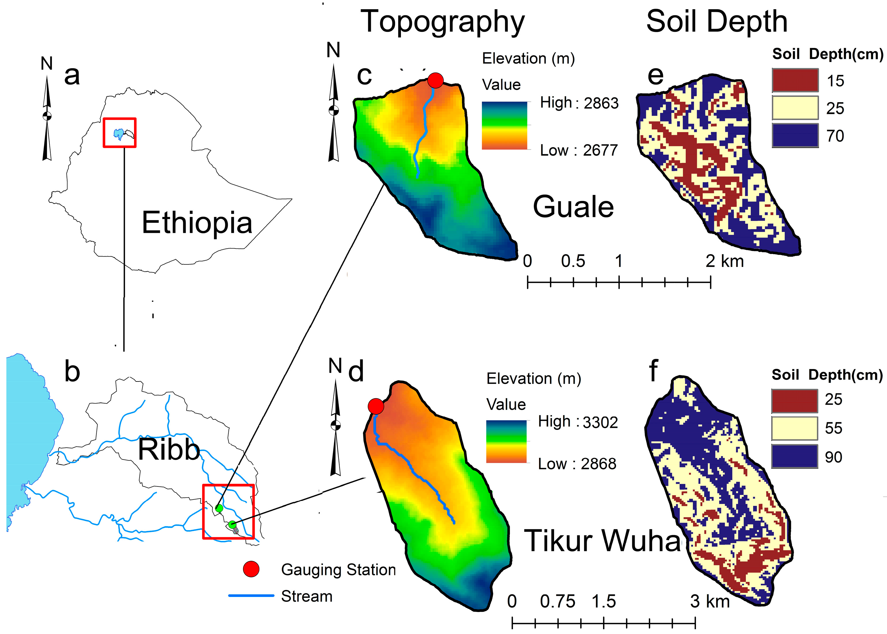
Figure 1. Location, topography, and soil depth of the Guale and Tikur-Wuha watersheds. (a) Ethiopia; (b) Ribb watershed and the Gumara River below and Lake Tana at the left; (c) topography of the Guale watershed; (d) topography of the Tikur-Wuha watershed; (e) soils depth distribution of the Guale watershed; and (f) soil depth of the Tikur-Wuha watershed.
Land 06 00078 g001
Figure 2. Typical soil and water conservation practices in the watersheds (Guale and Tikur-Wuha): (a) enclosed areas; (b) treated gully; and (c) stone faced bund.
Land 06 00078 g002aLand 06 00078 g002b
Figure 3. Mean monthly precipitation and discharge from 2010 to 2012: (a) Tikur-Wuha; and (b) Guale watershed.
Land 06 00078 g003
Figure 4. Daily rainfall and runoff of Tikur-Wuha watershed in 2010, 2011, and 2012.
Land 06 00078 g004
Figure 5. Daily rainfall and runoff of Guale watershed in 2010, 2011, and 2012.
Land 06 00078 g005
Figure 6. Flow Duration Curve of the Tikur-Wuha and Guale watersheds.
Land 06 00078 g006
Figure 7. Daily sediment concentration during the rainy phase in (a) 2010; (b) 2011; and (c) 2012 in the Tikur-Wuha and Guale watersheds.
Land 06 00078 g007
Table 1. Characteristics of the Tikur-Wuha and Guale watersheds.
Watershed CharacteristicsWatersheds
Tikur-WuhaGuale
Stream slope (%)511
Soil typeChromic LuvisolsChromic Luvisols
Land use/cover (%)
Crop land (%)5360
Forest, shrub & bush (%)2521
Bare land (%)137
Grazing land (%)812
Settlement area (%)0.20.4
Elevation range (m)2868–33032677–2863
Gully area (ha)4.22.4
Major crops were grownWheat, barley, potatoWheat, barley, potato
Source: Baseline survey report of the Tana Beles project (unpublished data).
Table 2. Soil and water conservation measures implemented in the Tikur-Wuha and Guale watersheds (2011–2012).
Soil and Water Conservation TypeTikur-Wuha WatershedGuale Watershed
2011201220112012
Fodder and woodlots (ha)0.38.52.40
Gully rehabilitation (m2)210010011000
SWCPs on agricultural lands (ha)4014.838.13.7
Degraded land treatment (ha) 29
Treated area (ha, (% of total area))40 (8%)52.3 (10%)40.6 (21.4%)3.7 (2%)
Table 3. Runoff depth during rainy period phase (May–September) precipitation in mm month−1 and runoff coefficient (RC) for the Tikur-Wuha and Guale watersheds from 2010 to 2012.
Tikur-Wuha Watershed
201020112012
RunoffRainfallRCRunoffRainfallRCRunoffRainfallRC
May411150.36251270.2013770.17
June331510.22221930.11462800.16
July794610.171105000.22734870.15
August814350.191254580.27643300.19
September391680.23511650.31341320.26
Total27313300.2133314430.2323013060.18
Guale Watershed
May20830.2433.31450.230390.00
June752320.3240.21520.26852700.31
July1354260.32153.44450.341424840.29
August1264090.311464490.331374460.31
September671940.35106.92850.38661860.35
Total42313440.31479.814760.3343014250.30
Table 4. Monthly and annual sediment yield (Mg ha−1 y−1) of the Tikur-Wuha and Guale watersheds from 2010 to 2012.
MonthTikur-Wuha WatershedGuale Watershed
201020112012201020112012
January1.00.00.00.90.00.0
Febuary1.30.00.00.30.00.0
March1.40.10.10.30.00.0
April4.60.10.00.30.00.0
May7.18.40.10.70.60.0
June12.24.55.017.50.61.3
July12.16.51.413.023.517.6
August9.91.11.410.118.56.7
September1.30.40.16.22.61.2
October0.20.10.20.10.20.4
November0.10.10.00.10.20.0
December0.00.10.00.00.20.0
Total51.121.58.349.446.427.2
Difference −58%−84% −6%−45%